Publisher’s version / Version de l'éditeur:
Vous avez des questions? Nous pouvons vous aider. Pour communiquer directement avec un auteur, consultez la première page de la revue dans laquelle son article a été publié afin de trouver ses coordonnées. Si vous n’arrivez pas à les repérer, communiquez avec nous à [email protected].
Questions? Contact the NRC Publications Archive team at
[email protected]. If you wish to email the authors directly, please see the first page of the publication for their contact information.
https://publications-cnrc.canada.ca/fra/droits
L’accès à ce site Web et l’utilisation de son contenu sont assujettis aux conditions présentées dans le site LISEZ CES CONDITIONS ATTENTIVEMENT AVANT D’UTILISER CE SITE WEB.
Technical Translation (National Research Council of Canada), 1964
READ THESE TERMS AND CONDITIONS CAREFULLY BEFORE USING THIS WEBSITE. https://nrc-publications.canada.ca/eng/copyright
NRC Publications Archive Record / Notice des Archives des publications du CNRC :
https://nrc-publications.canada.ca/eng/view/object/?id=06bfdf55-95be-4339-921c-08018c560489 https://publications-cnrc.canada.ca/fra/voir/objet/?id=06bfdf55-95be-4339-921c-08018c560489
NRC Publications Archive
Archives des publications du CNRC
For the publisher’s version, please access the DOI link below./ Pour consulter la version de l’éditeur, utilisez le lien DOI ci-dessous.
https://doi.org/10.4224/20386691
Access and use of this website and the material on it are subject to the Terms and Conditions set forth at
Cryogenic physico-geological phenomena in permafrost regions
Kachurin, S. P.; National Research Council of Canada. Division of Building
Research
PREFACE
This translation is the sixth arranged by the Permafrost
Subcommittee of the Associate Committee on Soil and Snow Mechanics
of the National Research Council of the Russian permafrost
publi-cation, "Principles of Geocryo10gy"
The first translation in this group was of Chapter VI entitled
"Heat and Noisture Transfer in Freezing and
tィ。キゥョセSoils" by G.A.
Martynov (TT-1065).
The second was of Chapter IV
General
Mechan-isms of the Formation and Development of Permafrost" by P.F. Shvetsov
(TT-1117).
The third was Chapter VII "Geographical Distribution of
Seasonally Frozen Ground and Permafrost" by I.Ya. Baranov (TT-1121).
The fourth was Chapter IX "Ground
セsオ「ウオイヲ。」・IIce" by P.S. Shumskii
(TT-1130) and the fifth Chapter X 'Groundwater in permafrost Areas"
by V.M. Ponomarev and N.I. To1stikhin (TT-1138).
This translation
of Chapter XI by S.P. Kachurin reviews the physical conditions
necessary for the formation of the surface features associated with
deep seasonal freezing and permafrost.
This is followed by a
dis-cussion of each of the types of features encountered in permafrost
regions.
The chapter concludes with a classification of the features
according to form and origin.
The Division is grateful to the Geological Survey of Canada in
arranging for the translation of this chapter in response to the
request of the ,Permafrost Subcommittee.
The translation was done by
Mr.
C. de Leuchtenberg, Translation Bureau, Department of the
Secretary of State and edited by R.J.E. Brown, Division of BUilding
Research, National Research Council.
Ottawa
November
1964
R.F. Legget
Director
NATIONAL RESEARCH COUNCIL OF CANADA Technical Translation 1157
Title: Cryogenic physico-geological phenomena in permafrost regions
(Kriogennye fiziko-geologicheskie yavleniya v raionakh s mnogoletnemerzlymi porodami)
Author: S.P. Kachurin
Reference: Principles of geocryology (permafrost stUdies), Part I, General
geogryology, Chapter XI. Academy of Sciences of the U.S.S.R.
Moscow 1959. p.365-398
(Osnovy geokriologii (merzlotovedeniya), Chasti pervaya, Obshchaya
ァ・ッォイゥッャッセゥケ。L Glava XI. Akademiya Nauk SSSR. Moskva 1959. s .365-398)
Translator: C. de Leuchtenberg, Translation Bureau, Department of the
CRYOGENIC PHYSICO-GEOLOGICAL PHENOMENA IN PERHAFROST REGIONS
Physical Conditions for Development of Geocryological Phenomena
The name "geocryological phycLco-igeo Logf.caI phenomena" applies to the specific cryogenic structures and textures of frozen ground, and to the diverse forms of micro- and macrorelief related to the processes of freezing and thaw-ing of the ground, as well as the accumulation and meltthaw-ing of ground ice.
m
this chapter, the cryogenic processes and phenomena and the physicalconditions of their development are examined mainly in the
geologico-geographi-cal aspect; physigeologico-geographi-cal processes in freezing, frozen and エィ。キゥョセ strata have been
examined at length in Chapters V, VI and IX.
The manifestation of cryogenic processes and phenomena is confined on the globe to regions of transitory frozen, seasonally frozen and perennially frozen ground (Fig. 22, chap. VII).
Frozen ground interacts with the components of the geographical environ-ment in its upper layer; the heat and mass exchange with the outer environenviron-ment occurs here and causes seasonal freezing and thawing, seasonal temperature
variations, water migration, accumulation and melting of ice, physico-mechanical and all other processes, reSUlting in geocryological phenomena.
The freezing of ground and the water in it. The freeZing of moist ground
.
is accompanied by various phenomena depending on the condition of the freeZing
of ground water. The latter may freeze: (a) without any visible migration
(pellicular water, hygroscopic water), (b) with free migration in soils such as pebble beds, gravel, coarse sand, etc. (gravitation water) and (c) under hydro-static and hydrodynamic pressure.
The freezing of water (or nIDisture) in the ground differs from that of
water in open vessels or water bodies. Free fresh water freezes at O°C, but
water in the ground freezes within a certain range of temperatures, depending
on its mineralization and the state of dispersion of the ground. Therefore,
frozen ground always contains a certain amount of unfrozen water which affects the physical properties of this ground and influences the course of the pro-cesses developing in it (Chapter V).
The property of water to expand upon crystallization and to contract at the transition from the solid into the liquid phase is extremely important. Owing to this property, pressures and stresses, which play an important role in
cryogenic processes, arise in freezing ground. It is essential also that the
-4-depending on the temperature, and the coefficient of volumetric expansion
reaches 10.50 - 16.33. The change in the volume of water, ice and mineral mass
under various temperatures leads to the development of certain peculiar
phenomena in freezing and frozen soil (fracturing, heaving, etc.).
Fluctua-tions in the temperature of frozen ground, accompanied by corresponding
changes of the liquid phase, influence the values of its resistance to compres-sion and shear.
The regelation, recurrent freezing and thawing of moist ground, is
extremely important in connection with cryogeology and geography. Regelation
weakens the cohesive forces between the soil particles and reduces the compres-sive and shear resistance of the ground, which can become poorly bonded or even
qUick when thawed. An example of the latter is the thixotropic quicksands in
the Far East although they are coarse grained, often containing large quanti-ties of gravel, pebbles and sand.
Ground ice occurs as lenses, partings and layers in the overburden and
horizons containing water when freezing takes place. This ice is formed on the
lower surface of the freezing layer of ground as well as in fractures. The
quantity of ice and the thickness of its layers depend on the composition of the freezing ground, the duration of freezing, the temperature gradient in the
freezing layer and other physical conditions. |セ・ョ a water flow freezes under
pressure, the accumulation of injected ground ice of considerable thickness becomes possible, e.g. in hydrolaccoliths (Chapter IX).
The migration of water (moisture), salt solutions and mineral (soil) masses under the influence of the freezing of the ground is no less important. The migration of water in combination with its freezing in porous moist soil is
the fundamental process producing the cryogenic structures and textures in them. Water migrates in thawing and freezing soils under the influence of temperature gradients, moisture, pressure, electrical forces, etc. (Chapter V).
I.A. Tyutyunov has detected in porous, freezing-soils a rather intensive
migration of dissolved salts. They regularly migrate in soils corresponding to
changes in the flow of moisture downwards or upwards depending on the season of
the year. Salts, and the water holding them, migrate in the already frozen
soil when the thermodynamic eqUilibrium is disturbed by the temperature fluctuations.
The melting of ice in the ground and the development of settlement and
hollows in the thawing ground. Ice in frozen ground is interesting from two
points of view. First, as a rock-forming mineral and second, as a reserve of
moisture accumulated in the solid phase. The classification of ground ice and
processes of its formation are described in detail in Chapter IX; here we shall examine the processes connected with its melting.
-5-The most important aspect of the process of ice melting in the ground is the transition from the solid phase of water into the liquid phase. This tran-sition begins in the capillaries and pores and then spreads consecutively into the larger pores, individual lenses, partings and larger ice masses.
As a result of the melting of the ice and thawing of the mineral matter, structural and textural changes take place.
The thawfng of frozen ground containing ice causes the above-mentioned weakening of the cohesive forces, a considerable reduction in the bearing capacity of the ground and subsidence under its own weight. In general, this subsidence corresponds to the quantity of the melted ice; this is of great significance in the de ve Lopmerrt of some geocryological phenomena, especially thermolcarst.
The formation of frost clefts. Water in the liquid phase attains on cool-ing its greatest density at a エ・ョセ・イ。エオイ・ of +4°C and on further lowering of its temperature it begins to expand until it crystallizes as ice; with a con-tinued lowering of the temperature the volwne of the ice decreases. Therefore when moist, porous soil freezes, its volume at first increases until most of the water in it freezes, and with further cooling of the now frozen ground, the volume begins to decrease.
The uneven changes of volume that come about with the uneven cooling of frozen ground generates in the latter disruptive stresses and the formation of a system of frost clefts (Dostovalov, 1952). The laws for the formation of these clefts were described in Chapter V.
The lowest moisture content in soil in which frost clefts wiil form on freeZing, as established by many investigators, is that moisture content which is close to the lower Atterberg liquid limit, or almost identical to the value which is close to the maximum of molecular moisture capacity after Lebedev
(Lebedev, 1930; Fedosov, 1940; etc.).
Cooled air and surface or atmospheric water upon entering the clefts fill them and freeze there as ice veins and layers. Thus, in regions with a cool climate and under natural conditions, frost clefts play an important part in the formation of ice structures in the upper layers of moist freeZing soils.
Nivation. Nivation is the process of weathering or disintegration of ground where snow patches (firn) persist throughout the summer; it occurs in arctic and sub-arctic regions and in high mountains of countries with temperate and warm climates.
I.P. Tolmachev (1899) was the first investigator to pay attention to this process and he correctly evaluated its geomorphological role in shaping the relief. This process received its name later in works of the geologist F. Matthes, 1900 (according to N.A. Solntsev, 1949).
-6-Nivation has been studied by many investigators, the majority of them
being Soviet geologists and geographers (I.P. Tolmachev, N.A. SOlntsev, G.D.
Rikhter, G.K.· Tushinskii, etc.). At the present time the development of this
process and its influence on the ground and relief have been more or less made clear.
A snow patch lying motionless on the セイッオョ、 contributes to its
disintegra-tion, during which the following processes take place: (a) frost-weathering of the ground;
(b) displacement of weathered material by small water currents flowing from the snow patch;
(c) formation of a gradually increasing depression at the place of a snow patch (nivation hollow).
At places where nivation hollows are located, the weathered material is
usually saturated with water. The period of light spring and fall frosts, when
the temperature fluctuates around OOC, is the time when events occur such as the fracturing of the material, freeZing of water in fractures, pushing apart
of the nlineral particles and gradual mechanical breakdown. At the same time it
is assumed that coarse-grained multi-mineral ground will break down more rapid-ly than fine-grained monomineralic.
When a nivation hollow thaws, new sections of ground lose protection against the influence of changes in temperature, become soaked with water and
are SUbjected to regelation. Water formed at the edge of a nivation hollow
wets the surface of the exposed ground continually and contributes to the
sliding of the wetted material. Small water currents are very important
because they erode small channels along which fines are carried away and in the cool period of the day cold air penetrates far into the nivation hollow
towards its centre (Boch,
1946).
The destructive work of a nivation hollow proceeds also in warm July and June days when most of the melt water is formed.
The intensity of nivation is different in solid and in friable ground: solid ground (monolithic crystalline) is most subject to disintegration when
the エ・セー・イ。エオイ・ passes through ODC; the disintegration of friable ground is
greatest when the air temperature is high and much water is formed (Solntsev,
1949).
Nivation produces firn or nivation silt (aleurite). Cryogeno-geological Formations
It seemS impossible to take all the variations of physico-geographical manifestation of cryogenic process in the permafrost region into account; more-over they are far from being adequately studied.
-7-A brief sketch of the most widespread cryogeno-geological and geographical
エッイョセエゥッョウ is given below.
Rock streams and other formations on the ground surface. Accumulations on
the surface and on mountain slopes of pieces and fragments of various dimen-sions, sometimes building up gigantic rock streams of shaped stone, lumps and fragments, are quite characteristic of countries with severe climatic
condi-tions, especially in regions with perennially frozen ground. These rock streams
are sometimes itermixed with fines derived from the disintegration of the same
parent bedrock (Fig.
83).
The formation and accumulation of clastic material is most intensive in
mountains. The greater the mountain elevation (absolute and relative) the
sharper the manifestation of denudation*; in it the physical and chemical weathering of the ground, with all the related processes, takes the leading role.
On the flat elements of mountain relief and on mountain slopes the result of these processes is the accumulation of a coarsely fragmented material, while
the finer particles are washed away by atmospheric precipitation. As the upper
parts of the slopes are denuded they are repeatedly exposed to disintegration. Recurrent freeZing, heaVing, thaWing and subsidence assist the ejection (freezing out) of rock fragments and their accumulation on the surface; this sometimes leads to the formation of peculiar "stone seas" (Hamberg 1915;
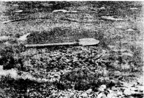
Belokrylov, 1931, etc.). The same fate befalls piles, posts, etc. (Fig.
84).
Monolithically frozen ground. Structures, textures and formation of this
ground is described in detail in Chapter IX.
A.M. Pchelintsev (1953), who did a special study of frost** or cryogenic
structure, classified perennially frozen ground according to structure 8S
follows:
(1) ground with fused structure; (2) ground with foliated structure;
(3) ground with conglomerate-breccia structure.
Every structural type of frozen ground corresponds to the special condi-tions of its formation.
Fused frost structure is characterized by a uniform distribution of ice which is invisible to the eye; the soil is not differentiated into aggregates
or layers with an alternation of mineral and ice inclusions. This structure
*
Up to the permanent snowline.**
What A.M. Pchelintsev terms "frost structure" is called "frost texture" or"cryogenic texture" by most investigators, i.e. the structure of frozen ground formed during freezing.
-8-indicates that either the moisture in the ground was insignificant before
freezing, or that the ground had good filtration アオ。ャゥエゥ・セN In these cases,
moisture in the ground is bound firmly to the soil particles and is not segre-gated into layers during freezing.
Foliated frost structure displays a differentiation of the mineral mass
and ice inclusions more or less visible to the eye. It indicates that during
freezing the soil was either saturated with water or water was drawn in from outside; at the same time the heat flow was normal to the planes of the mineral
and ice layers. Often the ground is intersected by vertical or diagonal ice
veins (along fractures). A thinner foliation indicates more rapid freezing of
the soil in coarsely foliated soil; the latter can arise with prolonged freezing
and when the freezing plane remains constant for a long time. In the opinion
of A.M. Pchelintsev, the foliated structure is most often inherent in soil of aqueous origin (clays, clay loams and sandy loams). According to P.A. sィキョウォゥセ
this is segregated ice (Chapter IX).
Conglomerate-breccia frost structure is a typical aggregate structure; it occurs when individual soil particles of diverse sizes (from rom to several cm)
are cemented by ice. According to A.M. Pchelintsev, this structure indicates
first that at the time of freezing the soil had a high moisture content in the form of gravitational water, and second that this Boil underwent repeated
freeZing and thaWing, the result of which was the differentiation of the mater-ial; but it is possible too that the soil had an aggregated structure before freezing and was filled with water on freezing which cemented the mineral aggregates.
Monolithically frozen soils are characteristic of the whole permafrost region, although frozen soils do not occur as a continuous layer; but they
extend over large areas. The continuity of frozen soils in space is disrupted
by tectonic processes, rock outcrops, river beds, lake basins and frost ヲゥウウセ
which crack the soil to varying depths below the surface. I t was mentioned
above that the ice content of the soil decreases to a minimum at a depth of 14 - 15 m, less often 20 m, and the ice content visible to the eye disappears entirely.
The ice distribution matches the temperature regime of the permafrost. According to F.G. Bakulin's (1958) conclusion, the ice content of dispersed perennially frozen ground, all other conditions being equal, is proportional
to the severity of permafrost conditions. Probably this phenomenon interacts
more complexly with the surrounding environement than the expressed law, but this problem has not yet been studied in detail.
Ice conglomerates, hydrolaccoliths, naleds. The main difference of ice
-9-often of a considerable thickness and extent, cementing the mineral aggregates of rocks into a monolithic mass; the ice content of conglomerates amounts to 50% or more of the volume of frozen ground (Koloskov, 1946).
An important Genetic condition determining the occurrence of a given type of monolithically frozen ground is the freezing of gravitational or moving water in the freezing zone and of water that is under hydrostatic pressure or under the action of forces that assist their migration. The duration and rate .of freezing are undoubtedly important and the thickness and size of the ice
lenses or layers which are formed depend on them. vlhen the action of cold upon the freezing soils is long and uniform, thicker lenses will be formed in them, whereas when the freezing is rapid and the change of temperature frequent, then thin layers of ice of lesser extent will be formed (Chapter IX). Other condi-tions for forming ice masses occur in areas comprised of coarse clastic materi-al, including coarse rubble, gravel, etc., accumulating in tectonically frac-tured rock zones or as sedimentary material, for example, at the foot of mountain slopes. The latter are very often the loci for the formation of ice conglomerates and naleds of subsurface as well as surface origin (Baranov, 1940; Sumgin et al., 1940). Outflows of ground-water springs occur most often at this type of locality, and laccoliths, naleds and other ice formations are
\
connected with them.
The ice conglomerates sometimes occur through the action of solifluction in mountainous areas of the permafrost region. Under the action of solifluc-tion, sedimentary material and water-saturated fines in it are carried down the slope, accwnulated there and converted by freezing to the typical ice conglom-erate (Fig. 85).
Ice-cemented gravels and sands of alluvial origin belong to the same category of ice-containing soils. Before freezing they were saturated fluvial deposits that froze later. In a series of cases, ice-cemented sands are a component of poorly sorted detritus.
Injected fine-grained loose soil into coarser soil. Under favourable conditions fine-grained slurry penetrates layers of more porous and coarse-grained soils. This phenomenon confirms, to a still greater degree, the,
migration of moisture in frozen and freezing ground. This migration is season-al, i.e. in winter it is directed upwards and in Surrilller downwards, in connec-tion with the posiconnec-tion of cooler layers (Fig.
86).
This is shown in the works of I.A. Tyutyunov (1951).To explain the development of a convex peat hummock with a frozen core in the tundra between the Kara and ObI Rivers, V.N. Sukachev proposed in 1911 the influence of winter (seasonal) freezing as the fundamental cause. D.A.
-10-in particular peat hunuuocka , fully accepts Sukachev's explanation, and adds,
that instead of a head of water under high pressure, as observed in the Far East (after K. Nikiforov, 1912), the hwnmocks in Western Siberia increase under
the slow action of freezing water. M.I. Surngin (1929) who developed the theory
of swelling with hummock formation, regards as fundamental the three causes of
hummock formation: (1) the existence of supersaturated ground above the
perma-frost, often in a quick state; (2) the influence of strain upon ground water
and slurry; and (3) their displacement from loci with high strain to those with
lesser strain, and the formation of hummocks there.
In later years the migration of mineral particles and moisture from one
point to another under the influence of freezing processes has been confirmed again in the works of A.I. Popov (19531) in Western Siberia, and of F.G.
Bakulin (1958) at Vorkuta. An interesting fact is the dewatering of the
deeper-lying horizons; ice layers are formed in the upper, more cooled ground layers
from moisture derived from the deeper horizons (Fig.
87).
According to F.G. Bakulinls observations, "dirty ice" is formed in the uppermost horizon of the permafrost mass under condttions of severe climate, and this ice is the result of water migration together with silty particles
during the freezing of the ground. Rapid water migration is required for the
formation of this type of ice and this is characteristic of the rapid freezing
of the upper layers of frozen ground. With a slow migration of freezing water,
pure ice, free of mineral admixtures, is formed.
Microscopic analysis of ice contaminated with mineral particles made by P.A. Shumskii (1952) has shown that ice crystals, while forming, entrap large rock particles but all fines are pushed away into the space between the
crystals.
Naleds and outpourings of soil masses on to the surface during the
freezing of soil and friable rock. Naleds are ice formations, forming in
winter from water flowing out on to the surface of the soil or ice when the ground and water bodies freeze through.
The cause of water flowing on to the surface can result from the emergence of ground water under pressure (springs) and the squeezing of ground water along fractures under the influence of hydrostatic and hydrodynamic pressures when the seasonally and perennially frozen layers of ground freeze together, as well as when swamps, creeks, rivers, etc., freeze.
It is possible to divide the naled formations, into three types depending on their origin:
(1) river naleds;
(2) ground water or surface naleds;
-11-Gigantic naleds or taryns should be separated as a special type
(Shvetsov and Sedov, 1941).
Naleds are a seasonal (winter) phenomenon. Only the largest of them,
including the taryns persist for more than one year.
The following empirical formula is proposed for calculating the volume of
naled water (Sumgin et al. 1940).
v
=
Q . セ . K+
A,where V セ volume of naled ice in m3
; Q - yield of the spring in m3 / h r ;
セ - time in hours from the beginning of naled development to the moment
of observation;
K
=
1.1 - the coefficient of water expansion at its conversion into ice;A - with the + or - sign, indicates the increase or decrease of a naled during its development time (including that due to snowfall, con-densation and runoff).
To simplify the determination of the yield of water, the calculation can be
V
made by the formula Q
=
セ.
K and A can be disregarded.The areas with naled ice developed on them are often confined to zones of tectonic disturbances - breaks, fractures, and the outflow to the surface of
deep ground water is confined to them. Taryns have a very important
signifi-cance in this respect, indicating outflows of ground water, and ッセエ・ョ
subperma-frost 'water in the majority of cases (Shvetsov and Sedov, 1941). Some gigantic
naleds have huge dimensions, e.g. the Kyra-Nekhoransk - 26 sq km and the Morna
100 sq km.
Very wet soil of varying mechanical 」ッョセッウゥエゥッョL but with a prevalence of
silty and clayey particles, pour out on to the ground surface in certain cases
when freezing, e.g. when frost clefts arise in this ground. The outpouring of
slurry occurs sometimes because of man's activity; the outflow of quicksand-like masses occurs often during thawing rather than freezing of the previously frozen ground in the bearing media of structures (under foundations, etc.) or when excavations are made in corresponding areas.
The disturbance of the soil and other horizons during freezing. The
processes, that occur in the freezing ground layers, very often disturb the soil and underlying horizons by displacing them relative to their original
position. The most typical results of these processes are the spot-medallion
heaving hummocks, small thermokarst subsidences, "boiling kettlesll
, etc.
The disturbance of the soil and underlying horizons is expressed
-12-fractures, uplifts (\'lal'ping) or subsidences relative to their initial position, and in other cases by contraction, expansion or spreading (creeping) combined with horizontal displacement of the soil and underlying layers, i.e. oy changes in structure and texture of the material comprising those layers. Often the entire soil layer and the underlying horizons are partly or completely destroy-ed in an area and are replacdestroy-ed by quicksand-type ntaterial from other horizons, of differing composition and structure (see Fig.
86).
All these processes are connected with seasonal freezing and thawing of the upper layers of the earth's crust. Frost clefts in the frozen layer have simultaneously great significance because they disturb the original continuity of the soil horizons. The development of these strains in the soil and rock along both sides of a cleft provides the Lmpu Lae for rock displacement, the up-lifting or subsidence of individual blocks and the release of stresses in the soil and at the ウ。ュセ time a change in its structure.
The disturbance of soil horizons comes about not only through the forma-tion of frost clefts; this disturbance is assisted by other phenomena such as soil heaving, solifluction, freezing, etc. Figure
88
shows the case of a sharp extrusion through the action of freezing to a height of25
cm above the ground surface of a rock block and the soil and sod layer covering it. Often the com-bined effort of several processes leads to deformation of the ground surface and the sharp disruption of the soil horizon and underlying layers.The disruption of soil and underlying layers by frost-cryogenic effects is described and discussed in the works of many native investigators (Sukachev,
1911;
Dranitsyn,1914;
Nikiforov,1912;
Sumgin,1927
and1937;
Kachurin,1939;
Moskvitin,1948;
and others). Data on these processes are available also in works of foreign investigators: B. H8gbom HQYQlセIL A. Porsild(1938),
J. Dulik(1956),
A. Washburn(1956),
and others. They produced イイセョケ names - involution, cryoturbation, congelifluction, etc. In recent years a very great significance has been ascribed to these processes in western Europe in connection with inves-tigations of the periglacial zone of ancient glaciations (Poland).Nival and solifluction formations. The development of nivation and
solifluction in countries with cold climate is the cause of specific formations. The development of nivation is greatly influenced by the relief, absolute and relative elevation, dissection, exposure to insolation and prevailing winds. Nivation occurs more often on slopes facing north than on any other slopes. The direction of prevailing winds contributes to a redistribution of the main masses of snow and the alteration of some of its properties (density, grain size, etc.).
According to N.A. So Lnt.aevts definition
(1949),
a "be Lt of n Lva t.Lon"-13-separates the rer;ion of glaciation (the ac curnuLat Lon and movement of glaciers), which is located to the north, or at a hir;her altitude than this belt, from the
region of erosion, which is located to the south, or at a lower altitude. The
zone of nivation displays features transitional between glacial and erosion
features. The largest nwnber of cirques and hanging glaciers is located near
the snow line in the mountains (Ural, Altai and others)j they can be considered as n<1ves of many years accumulation (Ka l.csnfk ,
1939;
Solntsev,1949
j Tushinskii,1949).
The processes of nivation are related directly to them.With respect to cryology, nivation is a factor influencing the regime and
, ,
development of cryogenic events because of the very mass of neve, and because of the moisture which, during the surrrrner, continually wets the surface layers
of soil near a neve and the slope below it. Nivation is often linked with
solifluction.
Solifluction is intensified under the influence of moisture that originates
through nivation or in SOlne other way. More often, however, solifluction
de-velops without the action of nivation. Solifluction originates often in areas
located considerably below the snow line, often where conditions for the
development of nivation do not exist, for example in the taiga where conditions for the re-blowing of snow do not exist.
Under the influence of solifluction a peculiar loose material is created which got the name "solifluction material" (Moskvitin,
1948).
Its chief and most typical component is silty material, supersaturated with waterj it contains as an admixture, depending on local geological conditions, coarser, fragmented material and organic remnants such as shreds of soil, peat or parts of variousplants, and in the frozen state, layers of ice. This material is similar to
talus but differs from it by a sharper display of cryogenic processes and the presence of a frost structure which may not exist in ordinary talus.
Solifluction participates in many cryogenic phenomena and processes as an
accompanying element - in heaving*, thermokarst formation, etc. The chief role
of solifluction is transportation, but in many cases specific formations come into existence through the action of solifluction in the form of variously
shaped micro- and macrorelief features (see below). On talus slopes
solifluc-tion contributed to the accumulasolifluc-tion of infiltrated-soliflucsolifluc-tion type of ice
(Kachurin,
1939).
All investigators have recorded an increase of solifluctiontowards the north and -towards higher altitudes, and a decrease towards the south.
In the most northerly regions solifluction is one of the leading processes
in reshaping the relief, and especially in the planation of mountains; it is a
-1):-power-f'uI and continuously actLng factor In levelling the relief and redistribu-ting the weathcr-cd mate r Lal s ,
Solifluction has a Lca d lrig role in the accunruLat.Lon and redistribution of useful placer m.tnei-aLs . Thus the identification of the component s of solifluc-tion help in the search for placers (Boch and Krasnov,
1951).
Pores, voids and other hollo\'ls in the groillld. Besides fractures, pores, closed VOlOS and other ho l Lows 0 L' various dimensions are often formed under: the
influence of frost and cryogenic conditions in the upper layers of the earth's crust.
The uBin cause of their origin is the action of external factors of
compression during the cooling and change of state of water. Because of these factors, the continuity of freezing and thawing soils is disrupted, and some sections of them are dewatered as water オセカ・ウ to other sections or wet soil masses are dewatered during their displacement (Bakulin,
1953;
Shumskii et al.1953) .
At the same time another very characteristic phenomenon is observed which is connected with the formation of hollows in frozen ground - they are the so-called "caves", "pockets" and similar formations, often filled \'1ith loose material which entered them as a slurry from other horizons.
As indicated by many investigators, hollows filled in this way are wide-spread both in the pennafrost region and in the region of seasonal freezing.
In the opinion of J. Dylik, A. 1. Noskvi tin and others, "caves", "pockets" and "kettles of boiling" all formed in loose soil during the period of glaciation on the Eurasian continent and give today very weighty proof, amid·other signs, of ancient cooling of vast territories in the European and Asian sections of that continent.
Cryogenic-Geomorphological Formations
Various エセセ・ウ of heaving. Heaving of freezing and frozen soils is one of the most universal processes in regions \'Ii th seasonally frozen and perennially frozen ground, as mentioned in the foregoing parts of this chapter. It depends on many physico-geographical conditions but the most important factors are the degree of cooling and the quantity of water in the groillld.
Depending on the character of the processes, the following fOrIas of heaving are distinguished: ィキッッセ」ォウ of heaving - seasonal and perennial, naled hUE@ocks - river and groillld naleds, fr?st mounds on roads, airfields, etc. and the general deformation of the earth surface.
Both general and local conditions and processes are inherent in all of the above-named types of heaving.
-15-HUllUuocks of heavinGs are of various types dcpend Ing on conditions of
their development. The largest hummocks occur in the permafrost region.
H.1. Swngin
(1937),
while explaining the theory of heaving of frozen soil,scrutinized two basic types of hummocks of heaving: hurrunocks that originate
without the influx of moisture from outside to the place of hummock development,
and hummocks formed "lith the influx of water from outside. According to the
theory of heaving, hummocks of various dimensions and other characteristics occur in both cases.
The theory of heaving in its present interpretation is presented in Chapter V and IX.
The majority of investigators believes that the development of such
hunIDlocks occurs in the following sequence: with the freezing of the soil
layer from above, the moist horizon lying beneath the freezing soil layer begins to undergo hydrostatic stress; because of this the frozen layer begins to bulge, and ruptures "lill occur along weaker sections; then a certain
quan-tity of water or slurry flows out of the ruptures to the surface. The surface
of the hummocks is always covered by sod, often with a peaty layer. Some
investigators believe that under undisturbed natural conditions, hummocks of
heaving are not formed in areas devoid of vegetation cover. On sod-covered
areas these such hummocks sometimes occur in large quantity (Lukashev,
1936;
Kushev,
1939;
Mordvinov,1940;
Sumgin et al.1940;
Porsild,1938;
etc.).The frozen crust of the hummock is not always ruptured; in the absence of a rupture an ice layer (vaUlt) is formed beneath the frozen layer of the
hummock, and below the ice layer, water remains liqUid under ーイ・ウセオイ・ for a
long time (sometimes through the year). K.O. Nikiforov
(1912)
states that inthe case of a hWmllock growing because of an influx of water, after the fractur-ing of that hurfUllock and outpourfractur-ing of a certain quantity of water and the
release of stresses, a new congelation of the fractures will occur, and that hummock will reSUDle its growth at the expense of the renewed pressure inside
its unfrozen core. After that a new ice layer is formed inside the hummock.
The described sequence of events is characteristic of hunrrnocks of
seasonal heaving. This applies also to the 、・カ・ャッーョセョエ of perennial hummocks
of heaving, the difference being that the ground-water pr'essure in the peren-nial hurmnocks is much greater than in the seasonal hummocks.
Hurrmlocks of heaving with ice cores acqUired the name of hydrolaccoliths in the literature, as proposed by A.V. L'vov, and later by N.l. Tolstikhin
(1932)
analagous to the typical laccoliths of magmatic rocks. The largestlaccoliths, reaching a height of
40
In and more, have been described for manynorthern regions of Asia and North America. In Central Yakutia they are known
under the Yakut name of bulgunnyakh and in North America as pingos; hydro-laccoliths are also known in Transbaikalia, Western Siberia, the European
-16-U.S.S.R. (Fig. 89) and the northern Urals (Andreev, 1938; Tolstikhin, 1941; Solov'ev, 1952; Porsild, 1938; etc.).
The development of Lar-ge hwrunocky formations is connected \'lith definite
morphological conditions of the areas where these formations exist. Hummocks
of this type are located in low-lying areas, often in flat closed lake depres-sions or swampy depresdepres-sions: the "alas" of Central Yakutia and the "laidy" of the Primor'e and other lowland areas are examples.
It is assumed that the development of bulgunnyakhs begins with the drying up of lake basins.
In the southern section of the permafrost region hummocks-hydrolaccoliths
commonly come into being at the outflows of ground water or springs (Baranov, 1940) .
Large hummocky peat bogs are a special variety of hummocks of heaving according to a series of investigators and particularly the later
investiga-tions of A.I. Popov (19531 ) in the northern part of Western Siberia and I.Ya.
Baranov (1951) on Kola Peninsula, and others.
A.I. Popov states that the formation of large hummocks on peat bogs is connected with the freezing of peat-moss sections; during this process a
uniform distribution of ice throughout the depth of the peat and in the
under-\
lying clayey, silty and similar soils occurs. The ice ヲッセョ。エゥッョウ are uniformly
distributed in the mass of frozen soil as a lattice in which horizontal ice layers combine with vertical ice veins.
Other points of view exist on the genesis of peat hwnmocks. According to
the ones most often found in the literature, the recent hummocks on peat bogs are remnants of a formerly single frozen peat layer, swollen a little during freezing of the water in it, but later dissected by frost cracks; this was followed by the destruction of the walls of the cracks, subsidence of the peat
along those cracks and the formation of the hummocks. The most persistent
defender of this theory of hummock ヲッイイイセエゥッョ on peat bogs is N.I. P'yavchenko
(1955). His opinion was disclaimed by I.Ya. Baranov (1951) and A.I. Popov
(1953,) as insufficiently founded.
Large hummocky peat bogs have their greatest development in the western part of the permafrost region of the U.S.S.R., in the northern part of the
European U.S.S.R. and in Western Siberia. At the same time the most typical
area of distribution, as indicated by all investigators of these areas (Govorukhin, 1947; Gorodkov, 1928; and others), is the extensive land area which gravitates to the forest-tundra subzone and especially to the northern border of the taiga, and commonly coincides with the southern border of the
permafrost region. In this zone frozen ground is confined almost exclusively
to the peat hummocks of heaving. In the eastern part of Siberia large hurrwocky
-17-Frost mounds on roads, airfields, etc. occur mostly through the seasonal
heaving of supersaturated soils. By this term it is understood that a local
raising of the soil occurs (from a few centimetres to 1 - 1.5 metres), begin-ning at the start of the winter, reaching its maximum development in midwinter
and disappearing in summer. They occur on roads, airfields and other areas of
communication under the influence of water expanding on freezing, whLch pene-trated under the road bed (or under any other structure), and they weaken the
carrying capacity of the pavement. Soil heaving in winter occurs almost
every-where, depending on the moisture content, soil composition and other conditions.
N.I. Sumgin called this phenomenon (1929) universal soil deformation; it is
very common on roads.
HWlilllock tombs (hwnmock mounds) are considered by some investigators as
evidence of heaving (Kushev, 1939; Mordvinov, 1940). This name is applied to
hummocks that resemble graves, but are of a larger dimension (from 0.5 - 2.0 m in height and up to 2.5 - 10 m in diameter); they are comprised of fine-grained soils and often occur in great nunmers, dotting an area either scantily or
abundantly. On older hwrunock mounds in the taiga, large trees may grow but
their stems are usually either bent or slanted in any direction, and on the whoLe resemble the so-called "drunken forest". Hummocks of this type are con-fined to flat areas, often in river valleys.
Several very diverse theories have been offered to explain the origin of
hummock mounds. Briefly, the major ones can be formulated as follows:
(1) Hwrunocks are developed under the influence of water expansion and hydrostatic pressure on freezing (heaving) of saturated soils (Kushev, 1939 and others).
(2) Hwmnocks are formed through washout of the surface and erosion of thawed soils on gentle slopes (Tumel', 1935).
(3) Hummocky formations are the results of the subsidence along fractures in thawing soil, which delineate the hwrunocky polygons, i.e. thermokarst
element (Baranov, 1940; Kachurin, 1953).
At the present time there is no unanimous opinion on the genesis of hwnmock tombs.
Thus, an examination of the various cryogenic-geomorphological formations connected with the processes of heaving that occur through the freezing of moist soils and underlying ground rocks has produced a great variety of forms, the occurrence and variety of which greatly depend on local
cryogenic-geological and other conditions. UndoUbtedly, heaving has a great significance
on cryogenic-geomorphological formations in areas where frozen ground occurs, and consequently on man's economic activity.
-Hl-Polygonal forwations on the earth's surface. A large quantity of
polYGonal or structural formations (Polyr;onboden, Structurboden)* occur on the earth's surface in areas where seasonally and perennially frozen ground is widespread, e.g. in the vast territory of the east and north of our country, as well as in other countries and on high mountains in the south.
All of these formations are basically microformations occurring most frequently as flat or slightly bulging round, multiangular or irregularly shaped polygons; some of them are bordered either by sod, small rock ridges, fragments or sharply expressed fractures, as well as fractures flanked by ridges running parallel to them.
The dimensions of the smaller forms vary from several centimetres to 1
-3 m; the largest of them reach 25 - 40 m.
The most typical polygonal formations or groups of formations are the
f'o Ll.ow.Lngt
(1) loam and stone polygons, stone networks, rings, stripes, etc. (Fig. 90, 91).
(2) fracture-polygonal formations, flat polygons, flat-hummocky, round-hummocky and other formations;
(3) polygonal-ridge formations (tetragonal) (Fig. 92, 93).
All the multiform polygonal formations can be divided according to their genetic and morphological features into two basic types and several sub-types of formations:
(1) structural formations, characterized by a peculiar structure and distribution of material;
(2) fracture formations with more or less homogeneous material.
A.L. Washburn expressed the same idea in his classification of polygonal
structures in North America (1956). In it the degree of sorting or non-sorting
of material is chosen as the basic ヲ・。エオイセ for relating the structure forms to
one of the classes. Accordingly he categorized the surface formations as
fol-lows: stone ridges, stone networks, polygons of frost-fracturing, polygons of
desiccation, steps and stripes. The external outlines of each form is used as
an additional feature.
All investigators of these formations agree that the following factors are
most important for their development: (1) severe climatic and soil temperature
conditions under the influence of which fractures and various cryogenic
*
The terms widely used in the ャゥエ・イ。エオイ・セ which are adapted from foreignlan-guages - (polygonal or structural soils), are unfortunate, because .soils do not participate in them; it is more appropriate to call them polygonal and structural formations or forms of the earth's surface.
II. Fracture formations
1. Substratum of uniform, well sorted, fine-grained material, of consider-able thickness, fairly moist.
2. Bedrock occurs either at depth, or is of no influence.
-19-processes are developing; (2) the presence of fines (fine sand, silt and clay fractions); (3) high moisture content whLch as a rule exceeds the maximwn molecular moisture capacity; (1q the presence of a t'later-resistant substance
(this is often frozen sround).
The genesis of all the above-enumerated types of formations has basically the same causes; the principal ones are:
(a) the freezing and thawing of moist fine-grained soils and associated phenomena (compression, expansion of wate r and mineral masses);
(b) rock fracturing due to sharp changes in エ・ョセ・イ。エオイ・ gradient in the freezing layer or moisture gradient in the thawing layer;
(c) dynamic and static stresses (forces) within a body of freezing ground delimited by fractures (visible and invisible); these stresses originate in winter during the freezing of the fines and in sunillier through the swelling of colloids.
Polygonal formations of .any shape occur depending on local conditions (topographical position, etc.), soil type, degree of moistening, etc.; some-times diverse shapes occur side by side in the same area.
The general conditions required for the creation of all types of polygonal formations are the following: flat, smooth surfaces, level or slightly sloping, severe climateic and soil t.emper-a tur-e conditions, supersaturation of soils in the seasonally and perennially freezing and thawing layer.
To illustrate and compare the influence of the various conditions required for the development of the above-named formations, the fundamental factors in-fluencing the development of polygonal formations are shown in the following listing.
I. Structural formations 1. Substratum of mixed, unsorted
material, usually of insignificant thickness.
2. Bedrock occurs near the ground surface; bedrock (weathered) is the source for replenishing the fine- and coarse-grained materials of the thawing and freezing layer.
3.
The action of forces during the3.
The action of forces during the period of freezing and thawing is period of freezing and thawing iscentrifugal. centripetal.
Characteristic of the structural forms are: the heterogeneous soil compo-sition, dynamic processes in the freezing layer, displacement of the coarse material from the lower layers up to the surface and a certain displacement of it on the surface; characteristic of the fracture polygons are: uniformity of grain size, the absence of dynamics (except contraction on cooling and
desiccation and cxj.ano ton on ィ」。G、Nャャイセ DlHJ ヲセQA」ャャゥョ」[IL and the cha r-pnesu of the fractures dcLtncat.Lnr; t.ho polYC:orw.
Individual LnvcstLga t.or-s indicate for Cl s er-Les of areas certain dcv LatLone from the above listinG, but these devintions refer mostly to details of devel-opment and in essence do not chan[r,c the Lcneral trend of develdevel-opment sho\'m on this listing. B.N. Dostovalov
(1952),
A.I. Popov(1952),
N.S. Sheveleva(1952)
and other investigntors consider the fractures to be the chief factor in form-ing all polygonal structures, and all other factors are subordinate. According to the observations of P.F. Shvetsov(1953)
in the north of the Yana-nldigirka region, the cnrly fnll period of soil freezing is the most important one for the creation of spot-nredallions, since because this is the time when fractures begin to be filled with ice.The development of clay loam spots on the soil surface in the Khibina tundra, as described by E.N. Ivanova 2nd N.A. Koposova
(1937)
is often caused by the mechanical expulsion to the surface of soil parts in the form of lIice s t a Lks11 due to the severe climatic conditions. As indicated earlier, 1.Ya.Baranov
(1950)
and I.A. Tyutyunov(1953)
have reported on this phenomenon with eood erounds for the Vorlcuta area.Polygons wade of c lay loam are known in the Lowl and areas of the North and in the high rnountains of Europe, Asia and other countries. Vast networks of polygons "lith all their morphological features are located, according to K.K. Ivlarkov, in the East Pamir Iilountains at altitudes of
4700 - 5000
m,The polygonal-ridge (tetragonal, orthogonal) formations (not shown in Fig.
94)
are set aside as a special category of polygonal phenomena. They differ from the above-described polygonal forms by their much lar£;er dimensions(25
m and more in dinmeter), as Vie11 as by the ir origin (Gusev,1938;
S. V.Obruchev,
1938;
Gorodlcov,1950;
Popov,1952;
Dostovalov,1952;
Leffing\'lell,1919;
and others).The r;rid structure (in plan) is the most typical feature of polygonal-ridge formntions (Fig.
92).
Besides, every polygon is bordered by a ridge of peaty mincral material0.5 - 1.0
m in height. Depressions run between the ridges of adjacent polygons, making on the vrho Le a tetragonal or polygonal net-Vlork of ditches joining each other at right anglcs; beneath these ditches lies a ne twor-k of vlcdr;e-shaped ice veins (Chapter IX). A longitudinal fracture is visible at the ditch bottom and sometimes such a fracture disappears beneath the surface of the ice vein. The ridges along the ditches originate through the lateral thrust of soil because of growing ice veins. Each polygon limited by ridges , ditches between them, and fractures at the bottom of the ditches, is either a flat or slightly concave depression, whLch often contains stagnan t wat er-.
-21-At the present time these forms are beinG shaped in the extreme North.
Dur-Ing the Quaternary period they wer-e developed in more southern regions
(e.g. Central Yakutia), as well as on flood plains of river valleys and lakes, which underwent later a stage of uplift and happened to be at the present time
on the surface of hieh second and third star;e terraces. Formations of this
type are widespread in other areas of the country, particularly on the vast plains of the northern Yana-Lena- Indigirlca-Kolyma terri tory, and where the
thickest masses of ground ice are associated with them (Chapter IX, Fig.
73).
The flat hununocky and rotmd hwnrnocky formations belong to a number of widespread forms of hummocky relief in the region of seasonally and perennially frozen ground and these forms must be examined now.
Flat hwmnocky formations described in most detail are those developed in the North of the European U.S.S.R. and Western Siberia (Baranov, 1951;
Gorodkov, 1928; and others). Having studied them N.I. P'yavchenko (1955) came
to the conclusion that the majority of the large hwrullocky formations on the peat bogs of the North are renmants of frozen peat bogs in the stage of
destruction. He presents a developnlent sequence for this type of hwnrnocky
re-lief and in it he assigns the main significance to the forces of denudation
(Fig.
94).
After giving the characteristics of the hwmnocky relief on peatbogs of the Kola Peninsula, I.Ya. Baranov (1951) criticizes the scheme and argwl1ents of N.I. P'yavchenko and offers in turn another scheme for the devel-opment of this relief; in it he assigns the main significance to the
frost-heaving of peat and soil, and secondary importance to all other factors. The
development of flat hwmnocky formations in the peat bogs as described by I.Ya.
Baranov apparently corresponds better to the natural phenomenon. L1 the
opinion of A.I. Popov the hW@locky formations in the peat bogs of Western Siberia arose initially through heaving; later the relief was complicated by
frost clefts and t.he rmokar-st phenomena. A.I. Popov also rejects scheme of
N.I. P'yavchenko.
Z.F. Ruoff gives in his wor-k (1951) interesting facts on nummocks on a
flat hwrunocky bog in the vicinity of Vorkuta. The analysis of pollen taken
from the peat layer on the hummocks and from a low erseya (a tortuous swampy canal between peaty hwnmocks) allows the author to disae;ree with the assumed denudation of peat deposits "because the upper parts of the pollen diagrams for
the erseya and the hummock" are almost identical. Thus the available facts
dispell the possibility of hwrunock formation (and the inter-hwrunock depressions) through denudation.
v!ith regard to the round hummocky formations, called "bar-dzhar-akhs "; which
are especially abtmdant where ice-vein systelns exist, most investigators have
-22-relief is due to the thawing of a tetragonal system of ice veins; at the same
time the r-emnant.s of frozen peat and soil are 13radually converted into flat or
round hununocky formations, (Saks, 195:3; Tikhomirov, 1948; and others) (Fig. 95).
Nivation and solifluction relief forms. Each of these processes has its
own typical relief formations. The forms of nival origin are: nival
depres-sions, corries, cirques, troughs (the last two forms, but of larger dimendepres-sions, come about through the action of glaciers), asymmetric slopes of ravines, creek and river valleys, abrasion-nival scarps of water basin shores and, in certain cases, small nival terraces and other relief elements.
Larger or smaller forms come into being depending on the quantity of snow
preserved through the summer (Fig. 96). vlhen snow accwnulates in large masses
the initially insignificant nival depressions can grow to large sizes and become either cirques, if they are located on upland slopes, or troughs, if their location coincides at first with a river valley, color saddle in the mountains.
Nival relief forms develop on ground of diverse mechanical and petrographic
composition. The accunlulation of snow and its protracted preservation during
the ウオョセ・イ season play and important part in this development. As a rule, snow persists for a longer time on slopes facing north, and hence affects the ground
there for a longer period. As a result, these slopes are more intensively
weathered and forms of nival origin are more numerous there than on slopes facing south.
Forms of solifluction origin are the different shaped small ridges, stripes, creep-tongues; and various upland, solifluction and other pseudo terraces. A type of microform called "swamp solifluction" sometimes occurs on wet swamps in the North (Anderson, 1906; Makerov, 1913; S.V. Obruchev, 1938; Kachurin, 1939; Boch and Krasnov, 1951; and others).
In the simple forms - stripes, ridges, creep-tongues, etc. - the
solifluc-tion acts as a transporting agent, 1.e. these forms originate directly from the flowing masses of water-saturated eluvium and detritus on the slopes of the
basic relief. It is expedient to designate these forms of microrelief as
typical flow formations.
In other more complex cases the solifluction is nO longer a simple flow
of supersaturated masses; in these cases, frost heaving, moisture migration, formation of ice lenses, displacement of qUicksand-type masses, displacement of
stones through heaving and other processes are inVOlved. A suitable term for
relief forms that originate through these processes is flow structural. The
main types are various pseudo terraces: altiplanation terraces, solifluction
Several diverse and :::;cncral hypothe:Jcs are offered by Hussian and
f'or-c Lgn authors for cxp La Lnf.ng thc 13onc3i3 of altiplanation and solifluction
terraces (Boch and Kra3nov,
1951;
S.V. Obruchev,1937).
Without listing allof them, it must be mentioned that there apparently exist in nature no less than two types of flOH-structural formations formed with the assistance of
solifluction but of a somewhat; different origin; these can be termed
altiplan-ation terraces and the others, solifluction terraces.
Each of these types has a peculiar structure but at the same time a nunfucr of features and conditions of development are conmlon to all of them. These include:
(1)
their development on mountain slopes in the presence of frozen groundin regions of severe climate;
(2) the independence of their origin from the petrographic composition
or resistance to weathering of the ground;
(3) solifluction takes part in their development;
(4) despite the external similarity, any connection in their development with processes that lead to the formation of typical terraces (river, lake, marine in the geomorphological sense) is completely absent.
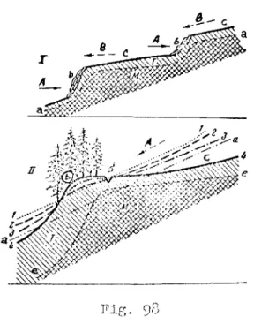
The distinction between altiplanation and solifluction terraces becomes very clear from the examination of schematic profiles of both types of terraces
(Fig. 98).
In the one case, namely, for typical altiplanation terraces, as learned
from scheme (I), in Fig. 98, the terrace scarp gradually recedes upwards
through the denudation of the bedrock; the denudation material does not remain
on it, and no plant can establish there. New sections of the rock are
continu-ously being SUbjected to destruction at the scarp foot under the influence of frost wea ther-ang assisted by constant wet t.Lng \'lith wat.e r that seeps down from above; at the same time as the denudation material is shifted dowmlard by
solifluction. In the end a small terrace with a scarp and platform is created.
In the other case of typical solifluction terraces (scheme II), the scarp
of the terrace is irrunobile; the scarp grows at the expense of material
carried downward by solifluction from the higher land and increases in height. The immobility of such a scrap is evidenced by well established trees and
bushes (in the taiga); they would not grow if their root systems were disturbed
by movement of the scarp. when several terraces are formed simultaneously on
one slope, the lower terrace develops at the expense of the upper. This last
feature is typical for both types of terraces.
Altiplanation and solifluction terraces are widespread on upland slopes
throughout the entire permafrost region. At the same time it becomes clear
-2-'1-the country und of higl1er mountains in -2-'1-the sou-2-'1-thern part (in -2-'1-the bald tundra zone), and typica 1 solifluction terraces in the mor-e southern parts and the Lowe r slopes of the mountains (in the taiga zone), i. e. their formation r-equ.li-es less severe frost climatic conditions than the former terraces.
The role of solifluction is not linlited by the described phenomen and formations. In the Far North, e.g. along the arctic coast of Eurasia, soli-fluction is the prevailing process which shapes and reworks the mountain relief. Under these conditions solifluction leads almost everywhere to the planation of an area (Fig.
99).
Solifluction formations are current phenomena underpresent conditions of the nOl'th and east of our country, and also influenced the relief under past climatic conditions. These types of formations were identified in a series of areas in the region of Eurasian glaciation*, but they are covered by younger deposits. They have today a palaeogeographic significance which aids in
identifying the cryogenic regime of past geological periods.
Thermokarst or subsidence and cave-in relief forms. Thermokarst** or thermal karst, i.e. subsidence and cave-in formations on the earth's surface, arising through the thawing of ground ice, is one of the most widespread relief-forming phenomena in the permafrost region.
Thermokarst comes about under the influence of changes in the heat circulation in the upper layers of the earth which cause melting of the ice contained in" the frozen layers, resulting in subsequent subsidence of the upper thawed layers.
Therrnokarst is a specific phenomenon in the region of permafrost and ice occurrences, and it cannot develop outside that region. In this way it differs from all other subsidence and cave-in phenomena on the earth's surface, includ-ing karst. A certain distant similarity exists between karst and thermokarst relief forms - funnels, pits, sinkholes, IIsaucersll, kettleholes, etc., but there are great differences too, e.g. thawed lakes, thermoterraces and other forms are not natural to karst.
Thermokarst as a natural phenomenon occurs where the ground contains ice. The main condition on which thermokarst development depends is the
presence of ground (fossil) ice in the upper ground layers; the main cause of this phenomenon is the change in the heat regime of the ground which leads to ice melting (Kachurin,
1956).
*
In the periglacial zone.**
The term IIthermokarst ll was introduced into the Soviet literature by M.M.-25-Hhen one of these conditions is missinc;, thermokarst cannot develop. The
subsequent dc ve Loprucrrt of t.ncr-mokar-st f'or-mc depend on the f'o Lfowf.ng conditions: the composition and structure of the surrounding ground, the structural and textural features of the ice, the presence or absence of any sort of vegetation
cover, etc. Human activity is of particular importance.
All types of ground ice can serve and do serve upon melting as the cause
of the development of therrnokar-st forms. The largest thermokarst forms come
about through the melting of thick vein ice.
Taking into account the foremost shape-forming factors and conditions that assist them, it is possible to divide all subsidence, thermokarst forma-tions into the follmdng t.wo principal categories:
(I) thermokarst proper;
(2) thermokarst of mixed origin.
The presence of ground ice in quantity in frozen ground is of prime
importance to both categories of thermokarst (Fig. 100-101). One type or
another of fossil ice (vein, infiltrated solifluction, buried, migration, etc.)
is of great significance in the first category. In the second category the
type of fossil ice has no particular significance, but at the same time other physical geographic conditions become important because they cause variations
in the subsidence type of formation, namely, ground subsidence, when it is wetted after thawing (e.g. loess), suffosion (subsurface loss of fine
mater-ials), karst process, etc. Because of this factor, forms of the second
category carry double names: cryogenic-suffosion, cryogenic-karst, etc.
(Kachurin, 1953).
Besides the forms with clear indications of subsidence origin, a large number of other forms exist in which subsidence is somewhat obscured (e.g.
thermoterraces, thermoabrasion etc.), or in which the melting of ice marking
the beginning of the thermokarst process, brings about a complete change in the area (e. g. "disappearing islands").
Thermokarst, like all phenomena in the permafrost region, is subordinated
to a certain degree to the cryogenic-geographical zonation. sッョセキィ。エ different
thermokarst formations are developed in the northern and southern zones, corresponding to the difference in the prevailing ground ice types and other conditions.
Besides the forms of contemporaneous origin, the different zones of the permafrost region retain subsidence forms of ancient origin, and many of them
can be regarded as relics. Forms of relic thermokarst exist also outside the
permafrost region. These include the subsidence formations which originated
through the melting of buried ice masses of the ancient continental glaciation (Gerasimov and Markov, 1939); according to many investigators, they include
-26-funnels and sinkholes in the region of the Putorana Mountains (Mikhailov, 1947; Saks, 1953), and in the northwest of the European U.S.S.R., on the Kola
Peninsula, in Karelia, in the regions of Leningrad, Vologda and other areas, which were covered by ancient glaciation and where detached ice イセウウ・ウ were buried beneath moraines.
The study of エィ・イュッォ。イセエ assists in the solving of questions of practical significance, for example, in the construction of bUildings, roads, etc. The role of thermokarst is most perceptible in all cases of construction, especially when buildings emit heat, in areas of massive ground ice. In these areas the role of thermokarst is very important in agriculture.
The chief measures for preventing the harmful effects of thermokarst development are based on the principle of the least disturbance of the natural
thermal conditions on the site of a future bUilding as well as on the best possible drainage on those sites by removing surplus surface water.
Erosional relief forms in permafrost regions. In these regions erosion proceeds somewhat differently than in regions wher-e there is no permafrost. At the same time, the opinion widely accepted in the geographical literature that lateral erosion prevails over depth erosion in these regions is completely erroneous; it is claimed that the cause of this is the weakening of erosion of the frozen ground in the beds of water courses. But in reality a layer of thawed ground always exists at the bottom of any water course, and the effect of erosion upon this layer does not differ in any way from its effect outside the permafrost region. At the same time the opinion that lateral erosion is very important is quite correct; in this case the main erosional forms are recesses, overhangs, caves, intra-soil channels, -etc. The main cause of their development is the combined action of thawing and erosion. The erosion pro-cesses in permafrost, leading to the formation of any form of concave relief, have been studied comparatively little as yet, and more detailed studies are required.
Forms of naled origin. These cryogenic-geomorphological formations in the permafrost region are of some significance.
Naleds which form annually at the same place (e.g. spring outlet) to a great degree affect the underlying soil; they affect buildings even more if they are erected without taking naleds into account, The surface of naleds is usually eneven, often hummocky (Fig. 102), but besides hummocky naleds there are some of other types caused by the relief at the sites of their development
(Fig. 103).
The size of naleds and naled hummocks varies from a few metres to many tens and hundreds of metres in diameter, and from a fraction of a metre to .

![[PDF] Utilisation de PowerPoint ressource de formation complet | Cours informatique](data:image/gif;base64,R0lGODlhAQABAIAAAP///wAAACH5BAEAAAAALAAAAAABAAEAAAICRAEAOw==)