Journal de la Société Chimique de Mauritanie
Journal of the Mauritanian Chemical Society
Evaluation of groundwater chemistry and its suitability for the irrigation purpose in
semi-arid region: a case study of Ain Oussera plain, Algeria
F. Bouteldjaoui
1, M. Bessenasse
1,2, M. Boughalem
3, I. Mokeddeme
4, F. Aitnouh
5, M. Achak
6,
L. Oualkacha
7, A. Kettab
11Ecole Nationale Polytechnique (ENP), Laboratoire de Recherche Sciences de l'Eau (LRS-EAU/ENP)
10, Av. HacenBadi, BP 182 El-Harrach-Alger, Algérie theldjaoui@yahoo.fr; kettab@yahoo.fr
2Université Saad Dahlab, Soumaa, Blida, 09000, Blida, Algérie,bessenasse@yahoo.fr 3 Univ Ain Temouchent, BP 284 - 46000 Ain Temouchent, Algeria,
4 Faculté des Sciences et Technologies, dpt d’Hydraulique, PB 417, Université TAHRI MOHAMED, Béchar Algérie. 5 Centre National d’Etudes et de Recherches sur l’Eau et l’Energie, Université Cadi Ayyad Marrakech, Maroc
faitnouh@yahoo.fr
6 Université Chouaib Doukkali, Ecole Nationale des Sciences Appliquées, El Jadida, Maroc 7 Faculté des Sciences et Techniques de Mohammedia, B.P.146, Mohammedia, Maroc
Infos Abstract - Résumé
Received: 30 June 2018 Accepted: 15 August 2018 Keywords - Mots clés Irrigation, Hydrochemistry, Salinization, Semi-arid irrigation, hydrochimie, salinisation, semi-aride.
Corresponding authors emails theldjaoui@yahoo.fr
kettab@yahoo.fr
The area of study, Ain Oussera, is located in the semi-arid high plains of the Saharian Atlas (at about 200 km south of Algiers) with an area of about 3,790 km2. Groundwater is investigated in this study from the Albian aquifer, which is
considered a major source for drinking and irrigation water. Suitability study of groundwater for irrigation was conducted in the study area. The hydrochemical facies of groundwater was mostly Ca-Mg-Cl-SO4 type. Sodium permeability ratio
(SAR), sodium carbonate (RSC), sodium percentage (Na%), permeability index (PI), magnesium hazard and Kelly's Index. The US salinity diagram shows that 74% of the groundwater samples fall into C3-S1 and C4-S2 categories for irrigation, which need adequate drainage to overcome salinity problems for irrigational purposes. The permeability index indicates that 89 % of the groundwater samples are good for irrigation uses in the study area.
Dans la plaine d'Ain Oussera, caractérisée par un climat semi-aride et une forte évapotranspiration le recours à l’irrigation pour la majorité des cultures est inévitable. Le développement de l’irrigation s’accompagne, dans la majorité des situations, par l’apparition de processus de salinisation, de sodisation ou d’alcalinisation des sols à des degrés divers. L’objectif de ce travail est d’évaluer la qualité de ces eaux souterraines utilisées dans l’irrigation et les risques éventuels de la dégradation des sols de la plaine d'Ain Oussera. L’analyse physico -chimique des eaux de 27 forages utilisés pour l’irrigation a montré que la majorité des points d’eau de la zone étude sont caractérisés par la dominance d’un faciès chlorurée et sulfatée calcique et magnésienne (Ca-Mg-Cl-SO4). L’étude de
la qualité des eaux pour l’irrigation montre que la majorité des points d’eau étudiés (74%) se répartissent dans les classent dans les classes suivantes : C3-S1, C4-S2. Le diagramme de Wilcox montre que les points se répartissent comme suit : La classe excellente : cette classe représente 6% des échantillons d’eau analysée. La classe bonne : la majorité des points d’eau (56%) appartenant à cette classe. La classe médiocre : cette classe englobe 9% des points d’eau. La classe mauvaise : cette classe regroupe 29% des points d’eau de la zone d’étude.
2 Bouteldjaoui et al., Proceedings of JIC2017: J. Maurit. Chem. Soc., 01 (2018) 1-7
1. INTRODUCTION
Ground water is a significant source for drinking water supply and irrigation of agricultural land in many parts of Algeria, especially in semiarid and arid regions [1]. In these regions, groundwater salinization results from physical and chemical processes of the groundwater and leads to deterioration in water quality and reduction of usable groundwater [2]. The quality of water used for irrigation is essential for crop yield and the maintenance of soil productivity. The poor water quality affects crop yield as well as the physical condition of soil [3]. Salinity problems lead to loss of soil fertility and crop yield productivity [4]. The present study was carried out with the objective to evaluate the groundwater suitability for irrigation purposes using the sodium adsorption ratio (SAR), sodium percentage (%Na), residual sodium carbonate (RSC), the Kelly’s ratio (KR), the permeability index (PI), and magnesium hazard (MH) [5].
2. DESCRIPTION OF THE STUDY AREA 2.1. General setting
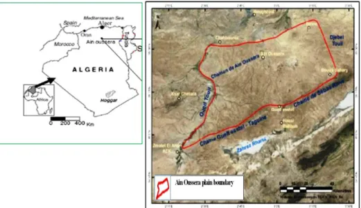
The Ain Oussera plain (Fig. 1) is located in the central part of northern Algeria between longitudes 2° 15' and 3° 45' E and latitudes 35° and 35° 40' N, and covers approximately an area of 3795 km2 [6]. The plain has a semi-arid climate type characterized with dry and hot summer and wet and cool winter season. The mean annual rainfall recorded at Ain Oussera meteorological station (from 1914 to 2011) 231 mm with a mean temperature of 17.1 ° C [7-8]. The annual mean potential evapotranspiration is 936.50 mm, which exceeds the annual rainfall [9]. Groundwater from the sandstone aquifer represents an important source for drinking water, agricultural and industrial purposes due to the scarcity of surface water [6].
2.2. Geology and Hydrogeology
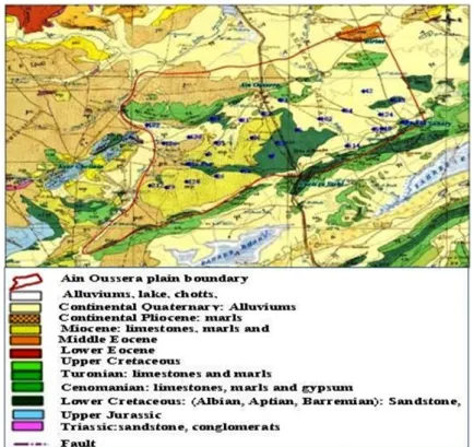
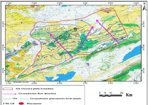
The geology of the studied area is investigated by several authors (Caritini 1970; Ayad 1983) [6, 10]. Most of the studied sites belong to the Cretaceous (Figure 2 and 3) and form a series of anticlines, the principal anticline axe passes by Boucedraia. The Cretaceous is mainly composed of fine clay sandstones, sandy limestones and coarse sandstone, sandy limestones, oolitic limestones and gritty formations, gritty sediments; limestone intercalations with dolomitic and marly limestones, and marls and gypsiferous clays. The Plio-Quaternary and the Quaternary outcrops occupy a large part of the Ain Oussera plain, they are considered by current and recent alluvial deposits: conglomerates, gravels, silts, crust, calcareous, etc. Groundwater investigated in the present study is from the Albian formations, which is known locally as the Ain Oussera sandstone formation. From a hydrogeological point of view, the Albian sandstones formations constitute the most extensive aquifer in the Saharian Atlas band. The average thickness of the Albian sandstone aquifer is about 200 m in the major part of the plain [11]. Pumping tests indicate that the transmissivity in the upper part of the aquif er varie s between 10-3 and 10-5 m2/s-1, and hydraulic conductivity ranges from 10-2 to10-6 ms-1 [6, 11].The groundwater flow is generally towards the north, the sandstone aquifer receives a direct alimentation from the southern limit (cretaceous formation of Gueltstel and Sebaa Rouss) (Figure 4).
3. MATERIALS AND METHODS
3.1. Sample collection an analytical techniques
A total of 27 groundwater samples (Figure 2) were collected from private and public wells for chemical analyses pH, temperature, and electrical conductivity of each water sample were measured in the field. The cation and anion concentrations in groundwater samples were determined in the Laboratory of the "Agence Nationale des Ressources Hydrauliques (ANRH)" in Algiers. Groundwater suitability for irrigation was assessed using electrical conductivity and sodium percentage (Na%), the US Salinity Laboratory’s diagram, sodium adsorption ratios (SAR), residual sodium carbonate (RSC), permeability index (PI), Kelly’s Index (KI) and magnesium hazard (MH).
3.2. Water quality irrigation indices 3.2.1. Sodium adsorption ratio (SAR)
The sodium adsorption ratio is commonly used to assess irrigation water suitability. It determines the degree to which sodium will be adsorbed by the soil. Sodicity indices were calculated using sodium adsorption ratios (SAR), computed using Eq. (1) [12].
The Na +, Ca2+ and Mg2+ concentrations are expressed in meq/L.
3.2.2. Sodium percentage (Na%)
The Na% is calculated using the formula (Eq. (2)) given below, where the concentrations are in meq/L
The Wilcox (1955) diagram uses sodium percentage and electrical conductivity to classify groundwater, which can be divided into five divisions (excellent to good, good to permissible, permissible to doubtful, doubtful to unsuitable, and unsuitable) [12].
3.2.3 Residual sodium carbonate (RSC)
RSC is also an important parameter to determine the suitability of groundwater for irrigation and is calculated using Eq. (3) [13]:
) ( / ) ( 2 2 2 1 Mg Ca Na SAR ) ( ) ( * ) ( 100 2 2 2 K Na Mg Ca k Na Na
4 Bouteldjaoui et al., Proceedings of JIC2017: J. Maurit. Chem. Soc., 01 (2018) 1-7
where all the concentrations are expressed in meq/L.
3.2.4. Permeability index (PI)
Doneen (1964) classified irrigation water based on the permeability index (PI) [14]. PI is defined as (Eq. (4)):
3.2.5. Kelly’s index
Kelly’s index (KI), calculated by using Eq. (5) is also used to classify irrigation ground water. Groundwater samples with KI < 1 are suitable for irrigation, while those >1 are considered unsuitable [15]. KI can be written as:
Ca2 2
(3) -3 3 CO HCO Mg l meq RSC( / )
(4) 2 2 100 3 K Na Mg Ca HCO Na PIFigure 3. Synthetic geological cross section of the Ain Oussera region (Ayad 1983)
Figure 5. Piper diagram for hydrogeochemical facies
where all the ions are expressed in meq/L.
3.2.6. Magnesium hazard (MH)
Szabolcs and Darab (1964) proposed magnesium hazard (MH) or magnesium ratio (MR) value for irrigation water as expressed by Eq. (6) [16]:
where all the ions are expressed in meq/L.
4. RESULTATS AND DISCUSSION 4.1. Hydrochemical facies
The concentrations of major ionic constituents (% meq/l) of groundwater samples were plotted in Piper trilinear diagram (Piper, 1944) to determine the water type (Figure 5) [17]. The diamond-shaped Piper
(5) 2 2 Mg Ca Na KI
100 (6) 2 2 Mg Ca Mg MH (b)Figure 6. a USSL salinity, and b Wilcox diagrams for the classification of irrigation water
6 Bouteldjaoui et al., Proceedings of JIC2017: J. Maurit. Chem. Soc., 01 (2018) 1-7
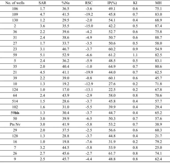
No. of wells SAR %Na RSC IP(%) KI MH
106 1.7 36.5 -3.6 49.1 0.6 75.1 109 4.7 41.5 -19.2 45.8 0.7 83.0 130 1.2 29.5 -2.0 54.1 0.4 68.9 2 3.6 35.5 -15.0 42.2 0.5 87.4 36 2.2 39.6 -4.2 52.7 0.6 75.8 31 2.4 38.6 -4.9 50.7 0.6 88.7 27 1.7 33.7 -3.5 50.6 0.5 58.0 23 3.1 46.7 -3.7 60.2 0.9 54.9 59 5.1 52.9 -6.6 61.2 1.1 82.5 5 2.4 36.2 -5.9 48.5 0.5 83.1 35 2.0 40.4 -1.0 64.9 0.7 80.6 21 4.5 41.1 -19.9 44.0 0.7 62.5 39 2.2 39.0 -0.8 60.1 0.6 45.7 10 1.3 19.2 -12.9 27.6 0.2 71.8 124 1.0 17.0 -13.1 22.5 0.2 67.8 64 2.4 43.9 -2.9 58.0 0.8 70.6 514 1.5 28.6 -3.7 45.8 0.4 57.7 102 1.6 31.0 -5.5 39.9 0.4 29.4 59bis 1.3 30.4 -3.7 44.7 0.4 65.2 50 3.0 39.9 -6.5 50.3 0.7 57.6 Pts Nv 3.0 41.9 -5.8 53.2 0.7 38.9 29 2.0 37.5 -2.5 56.6 0.6 60.3 128 1.3 28.8 -3.7 44.8 0.4 21.7 16 1.0 19.8 -7.6 31.9 0.2 79.2 7 3.2 44.5 -5.8 53.9 0.8 25.0 26 2.7 45.6 -2.7 61.7 0.8 74.1 9 2.5 45.7 -4.4 48.8 0.8 62.4
Table 1. Irrigation water water quality parameters of the groundwater samples
diagram field can be further classified into (1) Ca2+-Mg2+-Cl--SO
42- (2)Na+-K+-Cl--SO42- (3) Na+-K+-HCO3 -and (4) Ca2+-Mg2+-HCO
3-. The data represented in this diagram show that groundwater samples are classified into Ca-Mg-Cl-SO4 water type. The Ca-Mg-Cl-SO4 facies represents the groundwater type where reverse ion exchange is dominant.
4.2. Irrigation water quality
4.2.1. Sodium absorption ratio (SAR). The analytical data plotted on the US Salinity diagram (Figure 6
(a)) illustrates that most of the ground water samples fall in the field of C3S1 (66.7%) and C2S1(14.8%) and, indicating medium to high salinity and low sodium water, which can be used for irrigation on almost all types of soil with little danger of exchangeable sodium [18].
4.2.2. Percent sodium ion (% Na+). Wilcox diagram is widely utilized for evaluating the suitability of
water for irrigation using percent sodium and specific conductance (Figure 6(b)). The results indicated that 63% of the samples were in good to permissible category, 11% of samples falling in doubtful to unsuitable and 26% were falling in unsuitable for irrigation purposes [12].
4.2.3. Permeability index (PI). PI ranges 21.70 – 76.4% in the groundwater samples of the study area
(Table 1). According to the criterion, water can be classified as Class I, II and III. Classes I and II are categorized as good for irrigation with 75% or more maximum permeability. Class III water is unsuitable with 25% maximum permeability [14, 19]. In this study, 89% of groundwater samples fall in Class II.
4.2.4. Residual sodium carbonate (RSC). RSC is an important irrigation suitability parameter. The water
is considered safe if RSC values are <1.25 meq/L. RSC values between 1.25 and 2.5 meq/L indicate that water is of marginal quality. If RSC exceeds the value of 2.5 meq/L, the water is not appropriate for irrigation [13]. In the present study, groundwater samples show RSC values ranging from -21.6 and 0.1. According to RSC classification all the samples are good for the irrigation use (Table 1) [20].
4.2.5. Magnesium hazard (MH). If MH < 50 then it is considered as safe and if greater than >50 then it is
unsafe for irrigation use [15]. MH computed for the study area range from 21.7% to 88.7% (Table 1). In the analyzed water
4.2.5 Kelly's Ratio Index (KR). Groundwater samples with KI < 1 are suitable for irrigation, while those
>1 are considered unsuitable [21]. In the present study, KI values varied between 0.1 to 1 (Table 1). According to this KI classification, 96% of the samples are suitable for irrigation (KI < 1).
5. CONCLUSIONS
This paper describes the groundwater quality assessment carried out for Ain Oussera plain, Algeria. The suitability of groundwater for irrigation was evaluated based on the irrigation quality parameters like SAR, %Na, RSC, MH, KI and permeability index. Piper’s diagram showed that all of the hydrochemical facies in the area fall in the field of Ca-Mg-Cl-SO4 water type. According to USSL and Wilcox diagrams, most of the ground water samples were good to permissible for irrigation purposes. Furthermore, the value of RSC was negative at all sampling sites, indicating that there was no complete precipitation of calcium and magnesium. High salinity, %Na, RSC, and Mg hazard values at some locations seem to have limited the use of groundwater for agricultural activities.
REFERENCES
[1] A. Kettab, R. Mitiche, N. Bennaçar, Revue des sciences de l'eau., 21 (2008), 247-256. [2] A. Kettab, Desalination. Water Treatment., 136 (2001), 25-33
[3] R.S. Ayers, D.W. Westcot, FAO Irrigation and Drain., 1, 29 (1985), 1-109.
[4] P. Kumar, A. Kumar, C.K. Singh, C. Saraswat, R. Avtar, A. L. Ramanathan, S. Herath. Expo Health., 8 (2016), 19-30 [5] S.N. Sethy, T.H. Syed, A. Kumar, D.Sinha, Environ Earth Sci, 75 (2016), 232
[6] A. Ayad, DHG, rapport n°84. (1983), 18p
[7] F. Bouteldjaoui, A. Kettab, M. Bessenasse, Journal of Recent Technology and Engineering (IJRTE)., 5 (2016), 4-11 [8] F.Bouteldjaoui, A.Kettab, M. Bessenasse, Algerian J. Env. Sc. Technology, 2:1 (2017), 64-69
[9] F. Bouteldjaoui, M. Bessenasse, A. Gendouz, Revue Nature & Technologie, 7 (2012),109-116 [10] C. Caritini, Bull, 40, (1970), Tome I, 236p and Tome II. 305p. Algeria
[11] N. Mebrouk, B. Blavoux, A. Issaadi, V. Marc, Journal of Environmental Hydrology, 15 (2007),1-20 [12] L.V. Wilcox, U.S. Geological Department Agriculture Arc. 969, (1955), 19
[13] F.M. Eaton, Soil Sci, 69 (1950), 123-134.
[14] L.D. Doneen, Water Science and Engineering 4001, Department of Water Sciences and Engineering, University of California (1964)
[15] S.K. Sundaray, B.B Nayak, D. Bhatta, Environ Monit Assess, 55 (2009), 227-243
[16] I. Szabolcs, C.Darab, Proceeding of 8th International Congress of ISSS, Trans, vol. II (1964), 803-812. [17] A.M. Piper, Trans Am Geophys Union, 25(1944), 914-928
[18] L. A. Richards, Handbook 60, USDA, Washington D.C, 1954
[19] M. Ben Alaya, S. Saidi,. Zemni, F. Zargouni, Environ Earth Sci, 71 (2014), 3387-3421
[20] V.K. Singh, D.S. Sarswat, A. Bikundia, D. Mohan, Environ. Monit. Assess. 184 (2012), 4473–4488. [21] W.P. Kelly, Proceedings of the ASCF66, (1940), 607