HAL Id: hal-01909885
https://hal.archives-ouvertes.fr/hal-01909885
Submitted on 17 Dec 2018
HAL is a multi-disciplinary open access archive for the deposit and dissemination of sci-entific research documents, whether they are pub-lished or not. The documents may come from teaching and research institutions in France or abroad, or from public or private research centers.
L’archive ouverte pluridisciplinaire HAL, est destinée au dépôt et à la diffusion de documents scientifiques de niveau recherche, publiés ou non, émanant des établissements d’enseignement et de recherche français ou étrangers, des laboratoires publics ou privés.
Phytolith assemblages as a promising tool for
reconstructing Mediterranean Holocene vegetation
Claire Delhon, Anne Alexandre, Jean-François Berger, Stephanie Thiebault,
Jacques-Léopold Brochier, Jean-Dominique Meunier
To cite this version:
Claire Delhon, Anne Alexandre, Jean-François Berger, Stephanie Thiebault, Jacques-Léopold Brochier, et al.. Phytolith assemblages as a promising tool for reconstructing Mediterranean Holocene vegetation. Quaternary Research, Elsevier, 2003, 59 (1), pp.48-60. �hal-01909885�
Phytolith assemblages as a promising tool for reconstructing
Mediterranean Holocene vegetation
Claire Delhon,
a,* Anne Alexandre,
bJean-Franc¸ois Berger,
cSte´phanie Thie´bault,
aJacques-Le´opold Brochier,
dand Jean-Dominique Meunier
baArScAn, Maison de l’Arche´ologie et de l’Ethnologie, 21 Alle´e de l’Universite´, F92023 Nanterre Cedex, France bCEREGE-CNRS, Europoˆle Me´diterrane´en de l’Arbois, B.P.80, F13545 Aix-en-Provence Cedex 04, France
cCRA-CNRS, 250 Rue Albert Einstein, Sophia Antipolis, F06560 Valbonne, France dC.A.P. Valence, UMR 5594 du CNRS, 4 place des Ormeaux, F26000 Valence, France
Received 28 January 2002
Abstract
The reliability of phytolith assemblage analysis for characterizing Mediterranean vegetation is investigated in this study. Phytolith assemblages are extracted from modern and buried Holocene soils from the middle Rhoˆne valley (France). The relation between modern phytolith assemblages and the surrounding vegetation, as well as between fossil assemblages and contemporaneous vegetation, already reconstructed through other proxies, is discussed. We demonstrate that the main northwestern Mediterranean biomes are well distinguished by soil phytolith assemblage analysis. In particular, the density of pine and nonconiferous trees (densities expressed relatively to the grass cover) and the overall degree of opening of the vegetation appear well recorded by three phytolith indexes. North Mediterranean vegetation changes during the Holocene period, mainly tree line shifts, pine wood development and deforestation are poorly documented, due to the scarcity of proxy-preserving sites. Phytolith assemblage analysis of soils, buried soils, and sediments appears to be a promising technique to fill this gap.
© 2003 Elsevier Science (USA). All rights reserved.
Keywords: Phytolith; Pine; Paleoenvironment; Mediterranean area; Holocene, Buried soils
Introduction
The Mediterranean area is a transitional bioclimatic zone between temperate and tropical zones or between humid and arid zones. It is characterized by a staged vegetation (Ozenda, 1964) adapted to summer drought and cool win-ters. The Rhoˆne valley is located on the French northern side of the Mediterranean basin, below the northern limit of the Mediterranean climatic zone, and at the boundaries of the Medio-European and Alpine climatic influences. This location makes the Rhoˆne valley vegetation highly reactive to climatic changes and anthropic pressure. Moreover, a lot of archeological sites have recently been found in the Rhoˆne valley, during excavations preparing the construction of the
new “TGV-Me´diterrane´e” fast railway line, providing new environmental and archeological data.
The main vegetation changes in the northwestern Med-iterranean area during the Holocene period, have been re-gionally traced through pollen and charcoal studies (De Beaulieu, 1977; Triat-Laval, 1978; Jalut, 1974; Vernet and Thie´bault, 1987; Quezel, 1999). However, usual paleobo-tanical tools reach their limits in these sites.
The occurrence of pine in the Mediterranean vegetation is a marker of natural and anthropic stress. Pinus sylvestris is a species often considered as characteristic of mountain stage (Rameau et al., 1994), but its occurrence in southern areas (Tricastin, south Droˆme) shows that edaphic factors are probably as determinant as climatic factors in its distri-bution. In case of weak human pressure, the pine timberline goes down when the climate gets cooler and when soils deteriorate. This colonizing species is a heliophyte and a
* Corresponding author.
E-mail address: [email protected] (C. Delhon).
R
Available online at www.sciencedirect.com
Quaternary Research 59 (2003) 48 – 60 www.elsevier.com/locate/yqres
0033-5894/03/$ – see front matter © 2003 Elsevier Science (USA). All rights reserved. PII: S 0 0 3 3 - 5 8 9 4 ( 0 2 ) 0 0 0 1 3 - 3
pyrophyte, its spread being favored by fire, whether of natural or human origin (Pons and Thinon, 1987; Trabaud, 1989). As pine scatters great quantities of pollen, its varia-tions in pollen spectra have often only regional scale sig-nificance and local variations under punctual pressure are not distinguished. Retracing more precisely the history of pine in this area would mean retracing fire history, in which both climate and human action have a great part to play (Barbero et al., 1990; Bradshaw, 1993; Berger and Thie´-bault, 2002).
Pollen-preserving sites are scarce, especially for recent Holocene times (Argant, 1990; Argant in Berger, 1996). Since they only trace woody plants, charcoal records show limitation in detecting forest/grassland shifts in response to human or natural stresses. Moreover, charcoal fragments from archeological sites allow a determination of collected fuel species, but they give no information about the spatial distribution of the various vegetal associations.
These limitations argue for the use of phytolith blage analysis as a complementary proxy. Phytolith assem-blages, which are well preserved in oxidizing environments such as soils and buried soils, provide information on grass subfamilies (Twiss, 1992) and tree cover density (Alexan-dre et al., 1997, 1999; Barboni et al., 1999). Phytolith assemblage analysis has been used to trace with accuracy Holocene grassland dynamics and forest– grassland shifts in America, tropical Africa, and Asia (Kurman, 1985; Piperno, 1988; Tsutsuki et al., 1993; Inoue and Sase, 1996; Fredlund and Tieszen, 1997a,b; Alexandre et al., 1997, 1999; Barboni et al., 1999). Moreover, some studies have shown that pine species produce distinctive leaf phytoliths (Klein and Geis, 1978). At last, phytolith density (2.3), size (2–50 m for morphotypes with taxonomic value), and deposition pat-terns (they simply fall on the ground without any anemo-phile or enthomoanemo-phile transport) would argue in favor of distance transportation shorter than that for pollen.
Except for preliminary studies showing that phytoliths are well-represented in alluvial and colluvial deposits as well as in buried soils of the Rhoˆne valley (Alexandre and Meunier, 1997; Delhon, 1998; Verdin et al., 2001), phyto-lith assemblage analysis has never been applied to the north-ern Mediterranean area.
Before attempting a reconstruction of vegetation changes, it is essential to investigate first the reliability of modern phytolith assemblages for the recording of vegeta-tion sources. This preliminary study, even if dealing with a reduced number of samples, is the first step toward large paleoenvironmental phytolith-based reconstruction in the French Mediterranean area. Phytolith assemblages are ex-tracted from modern soils and buried Holocene soils from the middle Rhoˆne valley. The relationship between modern phytolith assemblages and the surrounding vegetation, or fossil phytolith assemblages and the contemporaneous re-gional vegetation, already reconstructed through other prox-ies, is discussed.
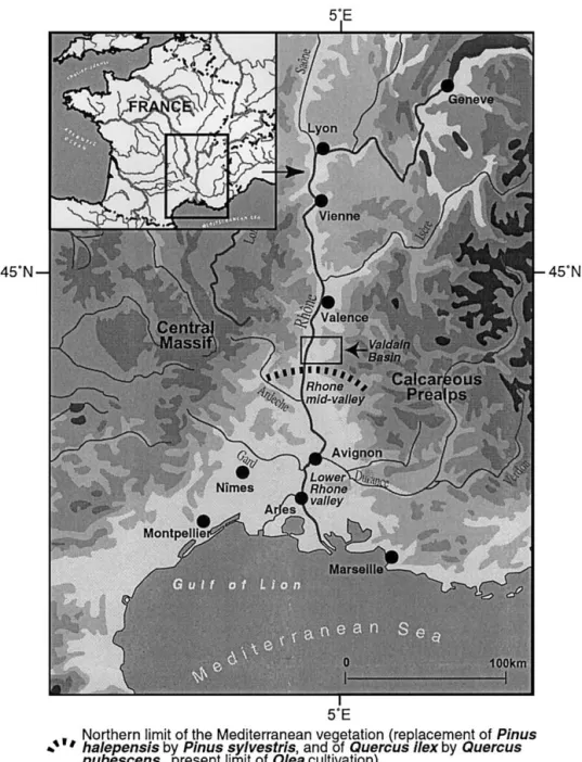
1. The middle Rhoˆne valley and the Valdaine basin
The middle Rhoˆne valley (Fig. 1) is located in southeast-ern France, between the Alps and the Massif Central. The average annual rainfall ranges from 800 to 1200 mm. Pre-cipitation is concentrated mainly over spring and autumn, while summer is affected by typical Mediterranean dryness. While the pluvio-nival river Rhoˆne flows continuously, its tributaries dry out in summer.
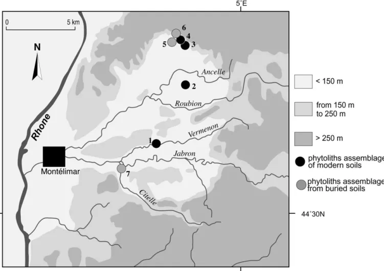
The basins of the Roubion and Jabron rivers together form the Valdaine basin (Fig. 2), mainly composed of Qua-ternary alluvial formations in the center, of marls in the foothills, and of limestone and sandstone on the periphery (Berger, 1996).
Because of three climatic influences (Mediterranean, Medio-European and Alpine), of microclimatic conditions related to various topographies (plains, slopes, hills and terraces), and of strong and ancient human pressure, the middle Rhoˆne valley landscape shows a mosaic of vegeta-tion typical for the supra-Mediterranean stage (Ozenda, 1964, 1994). Forests are oak coppices, dominated by
Quer-cus pubescens and pine woods (Pinus sylvestris). They
usually contain an undergrowth of trees and grasses. Pine woods are the pioneer formations after fire in the area, when oak groves settle only secondly (Pons and Thinon, 1987; Trabaud, 1989). The grasslands result mainly from grazing on the slopes. They consist of grasses belonging to the Festucoideae subfamily of Poaceae and of grazing-resistant dicotyledons. Riverbanks are covered by dense but small riparian formations dominated by Alnus and Fraxinus in the plains and Populus on the foothills.
2. Material and methods
2.1. Modern samples and local vegetation
As a selective dissolution of phytoliths occurs in litter and soil, reference classification must be based on modern phytolith assemblages from soil humic horizons. Therefore, five soil samples were collected from five spots located under main supra-Mediterranean vegetation formations (Fig. 2).
Sample 1 comes from a sandy-loam alluvial soil (mollic fluvisol according to the American “Soil Taxonomy,” Soil Survey Staff, 1975) located on the bank of the Vermenon river. This soil developed under a riparian forest dominated by Alnus and Fraxinus, with mainly Festucoideae grasses. This forest has been in place since the beginning of the 20th century which is the last period of deep incisions of river-beds in the area.
Sample 2 comes from a loamy-clay brown to red calcic soil (luvic calcisol) located on a gravely Wurmian terrace of the Roubion river. This soil developed under a bicentennial oak grove (Quercus pubescens) with a clear grassy under-growth layer (Festucoideae).
Sample 3 comes from a calcareous colluvial soil (rendzic leptosol) developed on recently stabilized Bad Lands on the marly south-orientated slopes of the Roynac hill. This soil developed under a grassland (mainly Festucoideae grasses), with scattered pines (Pinus sylvestris), that is not currently grazed. This soil should be younger than 100 years as photo-graphs from the beginning of the 20th century show that rills widely marked the slopes, preventing soil development.
Sample 4 comes from a clay regosoil (calcaric regosol) located on the marly south-orientated slopes of the Roynac hill. This soil developed under a pine wood (P. sylvestris) including some juniper (Juniperus communis) and a dense undergrowth grass layer (Festucoideae).
Sample 5 comes from a loamy and deep alluvial soil (eu-tritic fluvisol) located in the very low alluvial plain at the confluence of the Rhoˆne and one of its tributaries, the Aygues river. This soil developed under a reed (Phragmites communis) and grass cover (Festucoideae) around a drainage ditch. As the last sediment deposition occurred during the 19th century, soil and herbaceous vegetation cannot be older than 150 years.
2.2. Fossil samples and contemporaneous regional vegetation
Six fossil samples are studied. They come from dated levels of pedosedimentary sequences of three different sites.
Fig. 1. Location of the middle Rhoˆne valley: the Valdaine Basin and the North limit of the Mediterranean vegetation according to Ozenda (1994). 50 C. Delhon et al. / Quaternary Research 59 (2003) 48 – 60
The levels formed during Holocene vegetation and morpho-climatic regional phases that are well documented (e.g., Triat-Laval, 1978; Vernet and Thie´bault, 1987; Thie´bault, 1988; Leveau and Provansal, 1993; Berger, 1996).
Sample 6 comes from a buried soil collected at Roy-nac-le-Serre (Fig. 2), on the northern slope of the Valdaine basin. It developed ca. 5685 14C yr B.P. (Table 1), during
the Neolithic period of the area (around 6500 to 3800 yr B.P.). This period is characterized by the development of agro-pastoral practices that have since contributed to the extension of the opening of Atlantic oak forests.
Samples 7a and 7b come from a black buried soil and an alluvial deposit located at Roynac-les-Roches (Fig. 2). They postdate an early Holocene layer (9845⫾ 90 14C yr B.P/
Fig. 2. The Valdaine Basin. Location of the main sampling sites: (1) river forest of Vermenon River at “les feuilles” site, (2) “Andran” forest on gravely Wu¨rmian terrace, (3, 4) south slope of marly hills of Roynac, (5) prehistoric settlement of Roynac-le-Serre, (6) prehistoric settlement of Roynac-les-Roches, and (7) prehistoric settlement of Espeluche-Lalo.
Table 1
Radiocarbon dates cited in the text
Site Reference Structure Phase Material dated Matrix/context 14C yr B.P. cal yr B.C.:
2 sigmas
Lalo AA 32644 St. 8 17 Pit sediment 6220⫾ 60 5320–4990
AA32639 St.73 10 Pit sediment 6420⫾ 65 5490–5260
AA 24897 42 9b Charcoal layer Channel silt 6705⫾ 60 5720–5480 ETH 14840 Drilling 6b Charcoal layer Alluvial palaeosoil 6930⫾ 70 5990–5660 AA 24898 64b 5 Isolated charcoal Alluvial palaeosoil 7535⫾ 65 6470–6230 Roynac-les-Roches ETH15401 C5, 2,2 Ensemble 26 Charcoal layer Alluvial silt 9785⫾ 80 9500–8605 ETH1502 C25, d2 Ensemble 26 Charcoal layer Alluvial silt 9845⫾ 90 9710–8735 Roynac-le-Serre ARC 1443 St.A, soil S9 Phase I2b Charcoal cluster (hearth) Alluvial silt 5685⫾ 100 4775–4360
9785⫾ 8014C yr B.P, Table 1). They are related to the end of charcoal zonation phase 1 (from 11,000 to 8000 yr B.P., Heinz and Thie´bault, 1998), characterized by the dominance of P. sylvestris and Juniperus and to the end of Preboreal pollen subdivision (from 10,300 to 8900 yr B.P., Triat-Laval, 1978), characterized by the dominance of pine pol-len. Moreover, pine microcharcoal has been identified in sample 7b (Thie´bault, unpublished data). This pine-domi-nant open vegetation could be linked to cool and dry cli-matic conditions (Heinz and Thie´bault, 1998). Pedological studies show a concentration of microcharcoal and second-ary carbonate precipitation in these samples, which indi-cates a repetition of fire events and high evapotranspiration values (J.-L. Brochier, unpublished data). Epipalaeolithic and Mesolithic lithic items are associated with these pe-dosedimentary formations.
Samples 8a and 8b were collected in the low alluvial plain of the Citelle river, in the southern part of the Valdaine basin, at Espeluche-Lalo (Fig. 2). Sample 8a comes from a clayey-silted buried soil on the bank of a paleochannel. It is located between two sedimentary levels: the lower dated to 6705⫾ 6014C yr B.P. (Table 1), and the upper is attributed to an early neolithic settlement (6220 ⫾ 60 14C yr B.P., Table 1). The studied part of this sequence was abruptly buried by sediments, due to slope instability ca. 600014C yr B.P. (after 6930⫾ 7014C yr B.P. and between 6420⫾ 65 and 6220⫾ 6014C yr B.P., Table 1). Microcharcoal frag-ments extracted from this sample were dicotyledons and belong mainly to Quercus sp. (Delhon, 1998). Sample 8b comes from a rubified buried soil developed on late glacial silts deposed on the Wurmian terrace of the Citelle river. It developed contemporaneously with a black buried soil dated to 7535 ⫾ 65 14C yr B.P. (Table 1). Microcharcoal fragments found in this sample have been identified mainly as monocotyledons and oak (Delhon, 1998). Sample 8c comes from an alluvial level without pedological features, on the bank of the Citelle river. Multiplicity of its possible vegetation sources will be taken into account when discuss-ing its phytolith assemblage. These three samples are attrib-uted to the pollen Atlantic subdivision (from ca. 8000 to 5000 yr B.P.) and to the charcoal zonation phase 2 (from ca. 8000 to 6000 yr B.P.), both characterized by a dominance of deciduous oak forest (Triat-Laval, 1978; Vernet and Thie´-bault, 1987; Heinz and Thie´Thie´-bault, 1998). These charcoal and pollen zonations point out the main vegetation trends, but the dominance of deciduous forests does not exclude the persistance of open or less densly wooded areas.
2.3. Methods
About 10 g of dry material was analyzed. Phytoliths were extracted from the 2- to 50-m fraction after calcium car-bonate removal using HCl, organic matter oxidation using H2O2, particle size fractionation, and densimetric separation
in a ZnBr2 solution with a density of 2.35 (Kelly, 1990;
Fredlund and Tieszen, 1994). Phytoliths were mounted on
microscope slides in glycerol, which allows a three-dimen-sional observation. For each assemblage, more than 200 phytoliths of diameter greater than 5m were counted, at 500⫻ magnification.
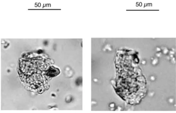
Phytoliths were classified into nine morphotypes previ-ously described (Twiss, 1992; Alexandre et al., 1997; Bar-boni et al., 1999; Runge, 1999): elongate, fan-shaped, point-shaped, rectangle-and-rondel, cross-and-dumbbell, smooth-spherical, rough-smooth-spherical, cork-cell like, and silicified vessel. A tenth morphotype was observed. Since it has not been previously described, we named it “spherical-with-sockets” (Fig. 3).
According to Twiss taxonomic classification of grass phytoliths (Twiss et al., 1969; Twiss, 1992), which was later improved by Mulholland (1992), elongate, point-shaped, and fan-shaped morphotypes are produced by the whole Poaceae family. Rectangle and rondel morphotypes are pro-duced in great amount by the Festucoideae subfamily, while cross-and-dumbbell morphotypes are produced mainly by the Panicoideae subfamily. The main exceptions to this pattern, in the Mediterranean area, is the production by
Stipa (Festucoideae) and Arundo donax (Arundinoideae, an
introduced humid soils tall grass) of a small amount of cross-and-dumbbell morphotypes.
The rough-spherical morphotype is produced in dicoty-ledon wood (Geis, 1973; Bozarth, 1992; Scurfield et al., 1974; Laroche, 1976; Piperno, 1988). Some studies called it “circular rugose” (Piperno, 1988; Alexandre et al., 1997, 1999; Barboni et al., 1999), others “rough sphere” or “rough-spherical” (Kealhofer and Penny, 1998; Runge, 1999). In order to emphasize its three dimensional-shape, we opt for the latter nomenclature. Previous studies have shown that the ratio D/P equals to dicotyledon rough- and smooth-spherical morphotypes (D) versus Poaceae morpho-types (P) in a phytolith assemblage was a reliable proxy for the tree cover density in intertropical areas (Alexandre et al., 1997, 1999; Barboni et al., 1999). Nevertheless, the dicot-yledon tissue from which smooth-spherical phytoliths orig-inate is still unknown. Silicified vessels are produced by
Fig. 3. Microphotographs of modern (left) and fossil (right) spherical-with-sockets pine morphotype. Bar is 50m.
dicotyledons (Piperno, 1988) but are scarcely found in soil assemblages (Alexandre et al., 1997). This is the reason why this morphotype is not taken into account when calculating D/P ratio. The cork-cell-like morphotype is not used here for ecological interpretation as it is produced by numerous families (Ellis, 1979; Alexandre et al., 1997; Barboni et al., 1999). The unclassified group is composed of phytoliths showing no identifiable shape.
3. Results
Both modern and fossil phytolith assemblages show a significant proportion of unclassified phytoliths (from 16.5 to 53.2% of the phytolith sum). Classified morphotypes are similar in modern and fossil samples (except silicified ves-sels found in only one fossil assemblage, 7b) and are ex-pressed (Table 2 and Fig. 4) as percentages of the sum of classified phytoliths. Confidence intervals have been calcu-lated for each percentage. They can be broad (due to the great quantity of unclassified phytoliths in some assem-blages), showing that low percentages must be cautiously discussed. A common point to all assemblages is the strong dominance of rectangle-and-rondel morphotypes, mainly produced by the Festucoideae subfamily, among the grass phytoliths with subfamily significance, while the cross-and-dumbbell morphotypes never surpass 2.3% of the classified phytoliths, which is not an amount significantly different from zero.
3.1. Phytolith assemblages from modern samples (Table 2, Fig. 4)
The grassland phytoliths assemblage is characterized by the absence of dicotyledon phytoliths (rough- and smooth-spherical) and the strong dominance of grass morphotypes (93%). Among the latter, the only subfamily significance is borne by the rectangle-and-rondel morphotypes. The spher-ical-with-sockets morphotype accounts for 6.3%.
The pine-wood phytolith assemblage shows the highest amount of spherical-with-sockets morphotype (20%) among modern assemblages. Grass phytoliths are again abundant (78%), while dicotyledon phytoliths, represented by the rough-spherical morphotype, do not exceed 1% (not signif-icantly different of 0). This assemblage gives a D/P ratio of 0.01.
The oak grove phytoliths assemblage presents a high amount of dicotyledon phytoliths: 13.8%, consisting of 12.5 and 1.4% of rough- and smooth-spherical morphotypes, respectively. However, grass phytoliths are still abundant (85.7%). This assemblage gives a D/P ratio of 0.16. Even if the cross-and-dumbbell morphotype reaches its maximum value in this assemblage, its occurrence remains nonsignif-icant with regard to the confidence interval. No spherical-with-sockets phytoliths were counted in this assemblage.
The riparian-forest phytolith assemblage presents a
pro-portion of dicotyledon phytoliths that is even higher than the previous assemblage (14.5%), and the rough-spherical mor-photype is better represented (8.3%) than the smooth-spher-ical morphotype (6.2%). Grass phytoliths are still abundant (78.2%). The D/P ratio reaches 0.19. The spherical-with-sockets morphotype does not reach 1%.
As for the grassland assemblage, the phytolith assem-blage from the reed formation is characterized by a strong dominance of grass phytoliths (97%). Some cross-and-dumbbell morphotypes are represented, but not in statisti-cally representative amounts (1.5%). Dicotyledon phytoliths (here smooth-spherical morphotype) reach only 2.5%. Thus, this assemblage shows a D/P ratio of 0.03 only. The spher-ical-with-sockets morphotype is not represented.
3.2. Phytolith assemblages from archeological samples
The phytolith assemblages of samples 7a and 7b were produced and deposited contemporaneously with the end of postglacial pine dominance. Both samples are characterized by the two highest proportions of the spherical-with-sockets morphotype (29.8 and 25.9%, respectively). Grass phyto-liths account for 59.5 and 52.8%, respectively, and their spherical dicotyledon phytoliths for 1.37 and 0. However, sample 7b is the only one showing a significant proportion of dicotyledon silicified vessels (7.5%).
The phytolith assemblage of sample 6 was deposited during a period of expansion of agro-pastoral practices, whose effects on the vegetal landscape are still under dis-cussion (Beeching et al., 2000). Grass phytoliths are numer-ous (87%); dicotyledon phytoliths account for 5%, equally divided among rough- and smooth-spherical morphotypes. All the grass phytoliths with subfamily significance come from the Festucoideae subfamily. No spherical-with-sockets phytoliths have been encountered.
Phytolith assemblages 8a, 8b, and 8c were deposited during the Atlantic period of oak forest development. As-semblages 8a and 8b show the two highest D/P ratios: 0.29 and 0.44, respectively. Dicotyledon phytoliths account for 21.47 and 28.48%, respectively, including both rough- and smooth-spherical morphotypes. Grass phytoliths represent 72.8 and 65.2%, respectively, and are dominated by rectan-gles-and-rondels. Cross-and-dumbbells morphotypes can be due either to the presence of Stipa (Festucoidae) or of some Panicoidae (e.g., Setaria sp.). The spherical-with-sockets morphotype is absent from assemblage 8a and accounts for 3.5% in assemblage 8b.
Assemblage 8c is extracted from an alluvial layer. The difference of this assemblage compared to 8a and 8b as-semblages lies in a far lower D/P ratio (0,10). Dicotyledon phytoliths account for 8.3%, including smooth-spherical (2.9%) and rough-spherical (5.4%) morphotypes. Grass phytoliths account for 84.3%. The spherical-with-sockets morphotype represents 3.9%.
Table 2
Abundance of the different phytolith morphotypes in modern and fossil assemblages Hypothesis on
taxonomic significance:
Non used Pinaceae Dicots Poaceae Ratios
Morphotypes: Unclassifieda Cork-cells
like phytolithsb Silicified vesselsb Spherical with socketsb Smooth sphericalb Rough sphericalb Elongate, point and fan-shapedb Rectangle and rondelb Cross and dumbbellb D/Pc Pi/Pd T/Pe ⫽ (D ⫹ Pi)/P Modern samples Riparian forest 1 35 6.2 0 0.5 6.2 8.3 19.7 58.6 0 0.19 0 0.19 Oak grove 2 16.5 0 0 0 12.4 1.4 45.6 37.8 2.3 0.16 0 0.16 Grassland 3 41.1 0.5 0 6.3 0 0 14.9 78.4 0 0 0.07 0.07 Pine wood 4 35.6 1 0 20 1 0 5.4 72.7 0 0.01 0.26 0.27 Reed formation 5 36.7 0.5 0 0 2.5 0 20 75.5 1.5 0.03 0 0.03 Fossil samples Roynac-le-Serre (grassland expansion) 6 80 8 0 0 2.5 2.5 71 16 0 0.06 0 0.06 Roynac-les-Roches (pine forest expansion)
7a 27.4 5.2 0 29.8 0 1.4 42.1 17.4 0 0.02 0.50 0.52
7b 53.2 13.9 7.5 25.9 0 0 45.3 7.5 0 0 0.49 0.49
Espeluche-Lalo (oak wood expansion)
8a 46.5 4.7 0 0 5 16.4 34.6 38.3 0 0.29 0 0.29
8b 41.7 2 0 3.5 25.9 3 29.3 35.3 0.5 0.44 0.05 0.50
8c 37 3.4 0 3.9 2.9 5.4 16.7 67.7 0 0.10 0.05 0.15
aIn percentage of the phytolith sum (all the phytoliths observed are taken into account).
bIn percentage of the classified phytolith sum (only significant morphotypes are taken into account). cRatio of Dicotyledon versus Poaceae phytoliths: D/P
dRatio of Pinaceae versus Poaceae phytoliths Pi/P eRatio of Tree versus Poaceae phytoliths: T/P
54 C. Delhon et al. / Quaternary Research 59 (2003) 48 – 60
4. Discussion
4.1. Toward a new phytolith index tracing broad-leaved tree cover density for the northwest Mediterranean area
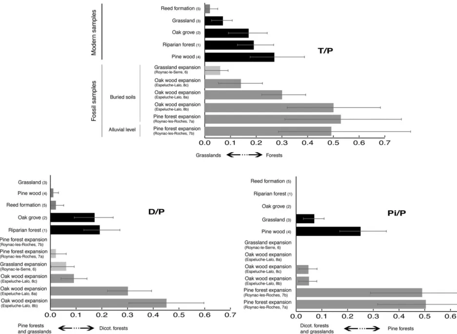
The D/P ratio equal to dicotyledon rough- and smooth-spherical morphotypes (D) versus Poaceae morphotypes (P) proved to be a reliable proxy of the tree cover density in tropical areas (Alexandre et al., 1997, 1999; Barboni et al., 1999).
In the present case, where gymnosperms can be well represented, investigation of relationships between D/P ra-tios and vegetation sources demonstrate that this phytolith index is a proxy of the broad-leaved tree cover density. Two types of assemblages can be distinguished by their D/P ratio (Table 1 and Fig. 5): The first shows D/P ratios higher than 0.1. It includes modern assemblages 1 and 2 collected under dicotyledon forests and fossil assemblages 8a and 8b con-temporaneous with oak forest development. Thus, high D/P ratios accurately record high broad-leaved tree cover den-sity.
The second group shows D/P ratios far lower than 0.1. It includes modern assemblage 3 produced by grassland, mod-ern assemblage 4 produced by pine wood, modmod-ern assem-blage 5 related to reed formations, fossil assemassem-blage 6 related to the Neolithic period, and fossil assemblage 7a related to the pine forest expansion phase. Low D/P ratios accurately trace a low representation of dicotyledon trees. Four assemblages among the five showing low D/P ratios contain statistically nonreliable proportions of dicotyledon phytoliths, which prevent more precise comparisons be-tween them. Fossil assemblage 8c, recovered from an allu-vial level contemporaneous with the oak forest develop-ment, shows a D/P ratio of 0.10. Because it has not been extracted from a buried soil, this assemblage is discussed below.
The D/P value of 0.1, used here as a lower limit to distinguish dicotyledon forest records from other records, is far lower than the previously published values of 7.0, 0.6, and 1.5, respectively, related to a semi-evergreen forest in Congo (Alexandre et al., 1997), a riparian forest in Ethiopia (Barboni et al., 1999), and a transition zone between a tree savana and a mesophytic forest in Brazil (Alexandre et al., 1999). Tropical broad-leaved forests are denser than Med-iterranean forests and the D/P ratio appears accurate enough to express this difference.
4.2. Toward a new phytolith index of pine cover density for the northwest Mediterranean area
Phytolith assemblages deposited under modern pine woods and during the Holocene pine expansion
(assem-blages 7a and 7b) are characterized by a high representation of the spherical-with-sockets morphotype, while this mor-photype is absent or scarcely represented in other assem-blages. The following discussion assesses the reliability of this morphotype for tracing pine cover.
Pine phytoliths have already been observed, in situ, in needles (Klein and Geis, 1978; Bartoli, 1981). However, observation scales varied and the spherical-with-sockets morphotype could not be surely recognized from published pictures. Our investigation of gymnosperm needle phyto-liths from the CEPAM-CNRS (Sophia Antipolis, France) reference collection showed that a Pinaceae, Picea abies, produces phytoliths presenting a spherical shape and bear-ing a special honeycombed ornamentation, similar to the spherical-with-sockets morphotype present in our modern and fossil assemblages (Fig. 3). Picea abies is not repre-sented in the area, but pine is a close relative. However, redundancy is inherent to phytolith production and there is no evidence that gymnosperms other than Pinaceae may not produce the same spherical-with-sockets morphotype. In the northwest Mediterranean area, pine (especially P. sylvestris for the supra-Mediterranean stage) and juniper (J.
commu-nis) have dominated the gymnosperm population since the
beginning of Holocene. We investigated needles of J.
com-munis, but no typical phytoliths were found. Since past and
modern formations dominated by pine produce high pro-portions of the spherical-with-sockets morphotype, we con-clude that this morphotype reveals the presence of pine in Holocene past and modern vegetation of the northwest Mediterranean area.
The Pi/P ratio of Pinaceae spherical-with-sockets phyto-liths (Pi) versus Poaceae phytophyto-liths (P) reaches values higher than 0.26 for assemblages produced by modern pine woods and during the Holocene pine expansion phase, while it does not reach 0.1 for the other assemblages. Thus, the Pi/P ratio appears to be a new and reliable proxy of pine cover density for Holocene vegetation reconstruction in the Rhoˆne valley.
In order to apply this new pine proxy to other areas, further investigations of phytolith production of various pine species and other gymnosperms are needed. This can be achieved by analyzing phytolith assemblages from soils of various modern gymnosperm formations.
4.3. Toward a new phytolith index tracing tree cover density for the north-west Mediterranean area
The northwestern Mediterranean area has experienced phases of forest opening since the beginning of Holocene, due either to climatic conditions or to human pressure, as shown by charcoal analysis (Vernet and Thie´bault, 1987; Heinz and Thie´bault, 1998). However, charcoal analysis is
Fig. 4. Phytolith percentage diagram of modern (black bars) and fossil (grey bars) Rhoˆne valley samples (with 95% confidence intervals:⫾ 1.96 兹共poqo兲
represented with dark grey bars).
Fig. 5. Graphic representation of T/P (Tree phytoliths versus Poaceae phytoliths) and of its two components, D/P (Dicotyledon phytoliths versus Poaceae phytoliths) and Pi/P (Pinaceae phytoliths versus Poaceae phytoliths) ratios, showing the boundaries between forests and grasslands, between pine forests and other formations, and between dicotyledon forests and other formations. Modern samples are represented with black bars and fossil samples with grey bars; in these two pools of samples, the ratios calculated from nonsignificant percentages are represented with lighter bars (T/P, sample 6 and reed formation; D/P, samples 6, 7a, pine wood, and reed
formation) 57 Delhon et al. / Quaternary Research 59 (2003) 48 – 60
unsuitable for detecting grass cover. Quantifying the degree of opening of the vegetation cover appears possible, using a new phytolith index, T/P, corresponding to the ratio of characteristic tree phytoliths, including angiosperm and gymnosperm species (T), versus Poaceae phytoliths (P): T/P
⫽ D/P ⫹ Pi/P.
Among our assemblages two groups are distinguished (Table 1, Fig. 5). Assemblages produced by forests show a T/P ratio higher than 0.15 (pine wood (4), 0.27; oak grove (2), 0.16; riparian forest (1), 0.19; Preboreal pine expansion (7a and 7b), 0.52 and 0.49; Atlantic oak wood expansion (8a and 8b), 0.29 and 0.50), while assemblages produced by grasslands show a T/P ratio lower than 0.1 (grassland (3), 0.07; reed formation (5), 0.03; local forest regression (6), 0.06). The vegetation density variations appear well-mir-rored by this T/P ratio. Even if more modern and fossil samples must be processed in order to validate the boundary values proposed here for each ratio, this demonstrates that the T/P phytolith index can be used as a quantitative proxy of the opening of the northwestern Mediterranean vegeta-tion.
All of the three indexes proposed here have shown ac-curacy in describing Mediterranean vegetation, but further studies are still needed in order to increase the number of assemblages analyzed and to decrease confidence intervals.
4.4. Space scale representation of phytolith assemblages from buried soils and alluvial deposit
The Pi/P, D/P, and T/P ratios from the five modern phytolith assemblages studied here reflect the pine repre-sentation, the broad-leaved tree reprerepre-sentation, and the opening degree of the top vegetation formations. Each re-lated vegetation patch is not older than 200 years and does not extend over large areas. Thus, the five phytolith assem-blages, extracted from soil humic horizons, record with accuracy the modern local vegetation. This result corrobo-rates the local representativeness of phytolith assemblages from soils, as already suggested by Bartoli and Guillet (1977).
Charcoal and pollen records from distant sites (Triat-Laval, 1978; Planchais, 1985; Vernet and Thie´bault, 1987; Heinz and Thie´bault, 1998) show that the Mediterranean vegetation has always had a mosaic pattern, even if a strong increase in heterogeneity, due to agro-pastoral practices, is recorded from around 600014C yr B.P. (Vernet et al., 1987). Phytolith assemblages from buried soils from similar or close (about 10 m) locations and dated to the same regional vegetation phase 7a and 7b and 8a and 8b give close phy-tolith indexes, in agreement with regional vegetation trends (pine forest development and oak forest development, re-spectively). However, assemblage 7b also shows a high amount of silicified vessels produced by dicotyledons that were never found in other assemblages. This can be ex-plained by a local vegetation feature, as the local presence of dicotyledons within the regional pine formations.
Assem-blage 7b comes from an alluvial level, and the vegetation heterogeneity is thus better recorded in this assemblage than in soil samples. Assemblages 6 and 8, both dated to the Atlantic period, record a grassland settlement and a broad-leaved forest, respectively. While assemblages 8a and 8b have been collected in the very low Citelle River alluvial plain, assemblage 6 comes from the slopes of the Roynac hill. The topographic heterogeneity may explain the heter-ogeneity of the vegetation’s responses to natural fires and anthropic stress. This shows that phytolith assemblage anal-ysis is accurate for reconstructing local variations of the vegetation, due either to local unstability of the ecosystem or to local pressure (especially human), inside the regional pattern given by pollen and charcoal studies.
Assemblage 8c, also contemporaneous with the Atlantic oak forest development, shows a middle D/P ratio and significant amounts of pine and grass phytoliths. Since it is recovered from an alluvial level, it includes phytoliths orig-inating from all the different patches of vegetation covering the Citelle basin at this time. Oak forest, scattered pine stands remaining from the previous phase or developed after fire, and opening areas linked to human disturbance could cohabit on the slopes, while the riverbanks would have been covered by riparian formations.
These results suggest that fossil phytolith assemblages extracted from buried soils record the vegetation features at a local scale, while phytolith assemblages from sedimentary layers are likely to reflect the regional mosaic of vegetation.
Conclusion
Phytolith assemblage analysis is applied to a north Med-iterranean environment. Although the number of processed samples is low, our results show that phytolith assemblage analysis is accurate for tracing local vegetation features otherwise unrecognizable by other proxies. Unlike pollen, phytolith assemblages are well preserved in soils and buried soils and give a local scale record. Unlike charcoal, phyto-lith assemblages give quantitative information on the degree of opening of the recorded vegetation. Phytolith assemblage analysis is consequently complementary to pollen and char-coal studies.
Three phytolith indexes have been displayed as accurate tracers of the Rhoˆne valley vegetation features. D/P ratio, corresponding to the ratio of dicotyledon spherical morpho-types (D) versus Poaceae phytoliths (P), traces broad-leaved tree cover density. Pi/P ratio corresponding to the ratio of pine spherical with sockets morphotype (Pi) versus Poaceae phytoliths (P), records pine cover density. T/P ratio, which is the sum of Pi/P and D/P ratios, records the overall tree (T) cover density or opening degree of the vegetation. The use of these three ratios in fossil phytolith sequences would greatly improve reconstruction of pine timberline shifts, oak forest development, and spatial and temporal variations of
the forest’s opening in the northwestern Mediterranean re-gion.
The main changes of the northwest Mediterranean veg-etation during the Holocene period were due to climatic stress and human disturbance. Distinguishing their respec-tive influence during the late Prehistory is still one of the main challenges for Mediterranean paleoenvironmental re-search. These first results show that phytolith assemblage analysis is a promising tool in this field.
However, in order to extend these results to other Med-iterranean areas, correlation between values of soil phytolith indexes and both floristic and physiognomic data of the various vegetation sources are required.
Acknowledgments
This study was done at CEREGE, Aix-en-Provence (France), in the framework of C. Delhon’s DEA. It was supported by the French new “TGV-Me´diterrane´e” fast rail-way and by the French program “Pale´oenvironnement, e´vo-lution des hominide´s—Hydrosyste´mes continentaux, pale´o-environnements et anthropisation dans le bassin-versant me´diterrane´en du Rhoˆne depuis le Tardiglaciaire” (J.F. Berger and M. Provansal, dir.). We thank T. Odiot (S.R.A. Languedoc, coordinator of the archeological excavations on the TGV-Lines), V. Bel (AFAN Me´diterrane´e), and the archeologists who excavated the archeological sites on the TGV line (mainly A. Beeching and J. Vital (CAP Valence/ CNRS) for the present paper). We also express a special thanks to P. Verdin (CEPAM-CNRS, Sophia Antipolis, France) for providing reference slides. We are also grateful to P. Anderson and M. Brooks for correcting the manu-script.
References
Alexandre, A., Meunier, J.D., 1997. Apports des travaux arche´ologiques du TGV-Me´diterrane´e en valle´e du Rhone a` l’histoire des paysages et du climat, des temps glaciaires a` nos jours. L’Analyse Phytolithique. CEREGE internal report.
Alexandre, A., Meunier, J.D., Le´zine, A.M., Vincens, A., Schartz, D., 1997. Phytoliths: indicators of grasslands dynamics during the late Holocene in intertropical Africa. Paleogeography Paleoclimatology Paleoecology 136, 213–229.
Alexandre, A., Meunier, J.-D., Mariotti, A., Soubies, F., 1999. Late Ho-locene phytoliths and carbon-isotope record from a latosol at Salitre, south-central Brazil. Quaternary Research 51 (2), 187–194.
Argant, J., 1981. Climat et environnement au Quaternaire dans le bassin du Rhone d’apre`s les donne´es palynologiques. Document du Laboratoire de Ge´ologie de Lyon 111.
Barbero, M., Loizel, R., Quezel, P., 1990. Me´diterrane´e: Les incendies et l’e´volution des foreˆts. La Recherche 22, 1154.
Barboni, D., Bonnefille, R., Alexandre, A., Meunier, J.D., 1999. Phytoliths as paleoenvironemental indicator at the Middle Awash hominid site, Ethiopia. Paleogeography, Paleoclimatology, Paleoecology 152, 87– 100.
Bartoli, F., 1981. Le cycle bioge´ochimique du silicium sur roche acide. Application a` deux syste`mes forestiers tempe´re´s (Vosges). Thesis, Universite´ Nancy I, France.
Bartoli, F., Guillet, B., 1977. Etude compare´e des diagrammes phyto-lithiques et polliniques d’un podzol des Vosges gre´seuses. Comptes Rendus de l’Acade´mie des Sciences de Paris 284D, 353–356. Beeching A., Berger, J.F., Brochier, J.L., Ferber, F., Helmer, D., Sidi
Maamar, H., 1977. Chasse´ens: agriculteurs ou e´leveurs, se´dentaires ou nomades? Quels types de milieux, d’e´conomies, de socie`te`s? Actes des 3e`mesrencontres me´ridionales de pre´histoire re´cente, Toulouse 1998.
Berger, J.F., 1977. Le cadre pale´oge´ographique des occupations du bassin du valdainais (Droˆme) a` l’Holoce`ne. Thesis, Universite´ Paris I, France. Berger, J.-F., Thiebault, S., 2002. The study and significance of charcoal as an indication of ancient fire: an application to the middle Rhoˆne valley (France), in: Thie´bault, S. (Ed.), Charcoal analysis: Methodological Approaches, Palaeoecological Results and Wood Uses. Proceedings of the Second Meeting of Anthracology, Paris, September 2000, Archaeo-press, 25– 41.
Bozarth, S.R., 1992. Classification of opal phytoliths formed in selected dicotyledons native to the great plains, in: Rapp, G., Mulholland, S.C. (Eds.), Phytolith Systematics: Emerging Issues, Plenum Press, New York, pp. 193–214.
Bradshaw, R., 1993. Forest response to Holocene climatic change: equi-librium or non-equiequi-librium, in: Chamber, F.M. (Ed.), Climatic Change and Human Impact on the Landscape, Chapman and Hall, London, pp. 57– 65.
De Beaulieu, J.L., 1977. Contribution pollenanalytique a` l’histoire Tardi-glaciaire et Holoce`ne de la ve´ge´tation des Alpes me´ridionnales fran-c¸aises. Thesis, Universite´ d’Aix-Marseille III, France.
Delhon, C., 1998. “Identification et interpre´tation de corte`ges phytolithai-res et anthracologiques a` partir de se´quences pe´dose´dimentaiphytolithai-res de milieux fluviaux en moyenne valle´e du Rhoˆne (Holoce`ne)-Apport a` la connaissance de l’anthropisation du milieu.” DEA, Universite´ de Franche-Comte´, France.
Ellis, R.P., 1979. A procedure for standardising comparative leaf anatomy in the Poaceae. II: The epidermis as seen in surface view. Bothalia 12 (4), 641– 671.
Fredlund, G., Tieszen, L.T., 1994. Modern phytolith assemblages from the North American Great Plains. Journal of Biogeography 21, 321–335. Fredlund, G., Tieszen, L., 1997a. Calibrating grass phytoliths assemblages in climatic terms: application to late Pleistocene assemblages from Kansas and Nebraska. Palaeogeography, Palaeoclimatology, Palaeo-ecology 136, 199 –211.
Fredlund, G., Tieszen, L., 1997b. Phytolith and carbon evidence for late Quaternary vegetation and climate change in the southern Black Hills, South Dakota. Quaternary Research 47, 206 –217.
Geis, J.W., 1973. Biogenic silica in selected species of deciduous angio-sperms. Soil Science 116 (2), 113–119.
Heinz, C., Thie´bault, S., 1998. Characterization and palaeoecological sig-nificance of archaeological charcoal assemblages during late and post-glacial phases in southern France. Quaternary Research 50, 56 – 68. Inoue, K., Sase, T., 1996. Paleoenvironmental history of post-Toya ash
tephric deposits and paleosols at Iwate volcano, Japan, using eolian dust content and phytolith composition. Quaternary International 34-36, 206 –217.
Jalut, G., 1974. “Evolution de la ve´ge´tation et variations climatiques durant les quinze derniers mille´naires dans l’extre´mite´ orientales des Pyre´ne´es.” Thesis, Universite´ de Toulouse, France.
Kealhofer, L., Penny, D., 1998. Fourteen thousand years of environmental change in northeast Thailand. Review of Palaeobotany and Palynology 103, 83–93.
Kelly, E.F., 1990. “Method for extracting opal phytoliths from soils and plant material.” Internal Doc., Dep. Agronomy, Colorado state univer-sity, Fort Collins.
Klein, R.L., Geis, J.W., 1978. Biogenic silica in the Pinaceae. Soil Science 123 (3), 145–156.
Kurman, M.H., 1985. An opal phytoliths and palynomorph study of extant and fossil soils in Kansas (USA). Palaeogeography, Palaeoclimatology, Palaeoecology 49, 217–235.
Laroche, J., 1976. La silice et les plantes supe´rieures. Revue de Cytologie et de Biologie Ve´ge´tale 40, 15– 45.
Leveau, P., and Provansal, M., 1993. “Arche´ologie et Environnement: de la Sainte Victoire aux Alpilles.” Publications Universite´ de Provence. Mulholland, S.C., 1992. A morphological classification of grass silica bodies, in: Rapp, G., Mulholland, S.C. (Eds.), Phytolith Systematics. Emerging Issues, Plenum Press, New York, pp. 129 –147.
Ozenda, P., 1964. “Bioge´ographie ve´ge´tale.” Douin, Paris.
Ozenda, P., 1994. “Ve´ge´tation du continent europe´en.” Delachaux et Ni-estle´, Paris.
Piperno, D.R., 1988. Phytolith Analysis. An Archaeological and Geolog-ical Perspective. Academic Press, New York.
Planchais, N., 1985. Analyses polliniques du remplissage holoce`ne de la lagune de Cnet (plaine du Roussillon, Pyre´ne´es orientales), in: De Beau-lieu, J.L., Pons, A. (Eds.), Palaeohydrological Changes in the Temperate Zone in the Last 15000 Years, Ecologia Mediterranea XI (1), 117–127. Pons, A., Thinon, M., 1987. The role of fire from palaeoecological data.
Ecologia Mediterranea XIII (4), 3–11.
Quezel, P., 1999. Les grandes structures de ve´ge´tation en re´gion Me´diter-rane´enne: facteurs de´terminants dans leur mise en place post-glaciaire. Geobios 32 (1), 19 –32.
Rameau, J.C., Mansion, D., Dume´, G., 1994. Flore Forestie`ere Franc¸aise, guide e´cologique illustre´. Tome 1: Plaines et Collines. Institut pour le de´veloppement forestier, Paris.
Runge, F., 1999. The opal phytolith inventory of soils in Central Africa. Quantities, shapes, classification and spectra. Review of Palaeobotany and Palynology 107, 23–53.
Scurfield, G., Anderson, C.A., Segnit, E.R., 1974. Silica in woody stems. Australian Journal of Botany 22, 211–229.
Soil Survey Staff, 1975. “Soil Taxonomy.” U.S. Dept. Agric. Hb. 436, Washington D.C.
Thie´bault, S., 1988. “L’homme et le milieu ve´ge´tal: analyses anthra-cologiques de six gisements des Pre´alpes au Tardi- et au Postglaciaire.” Documents de l’Arche´ologie Franc¸aise 15.
Trabaud, L., 1989. “Les feux de foreˆt-me´canismes, comportements et environnement.” Francese´lection.
Triat-Laval, H., 1978. “Contribution pollenanalytique a` l’histoire Tardi-glaciaire et postTardi-glaciaire de la ve´ge´tation de la basse valle´e du Rhone.” Thesis, Universite´ d’Aix-Marseille III, France.
Tsutsuki, K., Kondo, R., Shiraishi, H., Kuwatsuka, S., Ohnohara Wetland Research group, 1993. Composition of lignin-degradation products, lipids, and opal phytoliths in a peat profile accumulated since 32000 years B.P. in central Japan. Soil Science Plant Nutrition 39 (3), 463– 474.
Twiss, P.C., 1992. Predicted world distribution of C3 and C4 grass phy-toliths, in: Rapp, G., Mulholland, S.C. (Eds.), Phytolith Systematics. Emerging Issues, Plenum Press, New York, pp. 113–128.
Twiss, P.C., Suess, E., Smith, R.M., 1969. Morphological classification of grass phytoliths. Soil Science Society of America Proceedings 33, 109 –115.
Verdin, P, Berger, J.F., Lopez-Saez, J.A., 2001. Contribution of phytolith analysis to the understanding of historical agrosystems in the Rhoˆne mid-valley (Southern France), in: Meunier, J.D., Colin, F. (Eds.), Phy-toliths: Applications in Earth Sciences and Human History, A.A. Balkema Publishers, pp. 155–172.
Vernet, J.L., Thie´bault, S., 1987. An approach to northwestern Mediterra-nean recent prehistoric vegetation and ecologic implications. Journal of Biogeography 14, 117–127.
Vernet, J.L., Thie´bault, S., Heinz, C., 1987. Nouvelles donne´es sur la ve´ge´tation pre´historique postglacaire me´diterrane´enne d’apre´s l’analyse anthracologique. Actes du colloque international “Premie`res communaute´s paysannes en Me´diterrane´e occidentale,” Montpellier 1983, CNRS, 87–94.