Climate's watermark in the geometry of stream networks
The MIT Faculty has made this article openly available.
Please share
how this access benefits you. Your story matters.
Citation
Seybold, Hansjörg et al. “Climate’s Watermark in the Geometry
of Stream Networks.” Geophysical Research Letters 44, 5 (March
2017): 2272–2280 © 2017 American Geophysical Union
As Published
http://dx.doi.org/10.1002/2016GL072089
Publisher
American Geophysical Union (AGU)
Version
Final published version
Citable link
http://hdl.handle.net/1721.1/119825
Terms of Use
Article is made available in accordance with the publisher's
policy and may be subject to US copyright law. Please refer to the
publisher's site for terms of use.
Climate’s watermark in the geometry of stream networks
Hansjörg Seybold1,2 , Daniel H. Rothman1 , and James W. Kirchner2,3
1Lorenz Center, Department of Earth, Atmospheric, and Planetary Sciences, Massachusetts Institute of Technology,
Cambridge, Massachusetts, USA,2Department of Environmental Systems Sciences, ETH Zurich, Zurich, Switzerland,3Swiss
Federal Research Institute WSL, Birmensdorf, Switzerland
Abstract
Branching stream networks are a ubiquitous feature of the Earth’s surface, but the processes that shape them, and their dependence on the climate in which they grow, remain poorly understood. Research has mainly focused on climatic controls of channel incision rates, while the climatic influence on planform geometry has often been overlooked. Here we analyze nearly one million digitally mapped river junctions throughout the contiguous United States and show that branching angles vary systematically with climatic aridity. In arid landscapes, which are thought to be dominated by surface runoff erosion, junction angles average roughly 45∘ in the driest places. Branching angles are systematically wider in humid regions, averaging roughly 72∘, which is the theoretically predicted angle for network growth in a diffusive field such as groundwater seepage. The correlation of mean junction angle with aridity is stronger than with topographic gradient, downstream concavity, or other geometric factors that have been proposed as controls of junction angles. Thus, it may be possible to identify channelization processes from stream network geometry in relict landscapes, such as those on Mars.1. Introduction
The branching river networks that cover most of Earth’s landscapes are a visually striking fingerprint of the processes that shape them [Rodríguez-Iturbe and Rinaldo, 2001; Kirkby and Chorley, 1967; Montgomery and
Dietrich, 1992; Perron et al., 2012], and similar branching networks on Mars [Mars Channel Working Group, 1983]
and Titan [Tomasko et al., 2005] may likewise hold clues to the evolution of these planetary bodies. However, the linkages between the structure of these networks and the processes that shape them remain poorly understood [Montgomery and Dietrich, 1992; Perron et al., 2012]. Understanding how climate regulates land-scape evolution should yield insight into erosional mechanisms [Molnar, 2004; Riebe et al., 2004; Ferrier et al., 2013] and clues to paleoclimate, including on other planets [Pieri, 1980]. Although controls on vertical inci-sion rates are relatively well characterized [Whipple, 2004; Riebe et al., 2004; Zaprowski et al., 2005; Ferrier et al., 2012, 2013], observational data for characterizing controls on the planform geometry of river networks have been relatively scarce [Zanardo et al., 2014].
Understanding how climate affects the spatial pattern (and not just the vertical rate) of landscape evolution requires both (1) understanding how different erosion mechanisms depend on climate and (2) defining the geometric fingerprints associated with each process. Headward growth of river networks has been attributed to two distinct erosional processes: channel incision by overland flow [Horton, 1932, 1945] and the extension of the valley head by diffusive processes such as groundwater seepage [Dunne, 1969]. Overland flow occurs when rainfall exceeds infiltration capacity (or falls on saturated ground) and then follows the path of steepest descent downslope. More than seventy years ago, Horton [1945] proposed that surface erosion results from shear stresses induced by “almost imperceptible” sheet flows that accumulate beyond a critical distance from drainage divides. Channel incision by flows that follow the topographic slope is the dominant mechanism of landscape dissection in modern landscape evolution models [Tucker and Bras, 1998; Whipple and Tucker, 1999; Dietrich et al., 2003]. It is also thought to be the dominant process of channelization in arid landscapes, where flash floods are relatively common, hillslopes are unvegetated, and infiltration capacity is relatively limited [Molnar, 2004; Molnar et al., 2006]. However, half century ago, Kirkby and Chorley [1967] and Dunne [1969] questioned the applicability of the overland flow model in humid environments where soils are thicker [Pelletier and Rasmussen, 2009] and infiltration capacities are high. These landscapes are more likely to be shaped by groundwater seepage [Dunne, 1969] or other diffusive processes.
RESEARCH LETTER
10.1002/2016GL072089
Key Points:
• Mean branching angles of stream networks vary systematically with climatic aridity
• Branching angles in arid and humid landscapes average roughly 45 and 72∘, respectively
• Branching angles correlate more strongly with aridity than with geometric factors like topographic gradient or downstream concavity
Supporting Information: • Data Set S1 • Figure S1 • Figure S2 • Figure S3 • Figure S4 • Supporting Information S1 Correspondence to: H. Seybold, hseybold@ethz.ch Citation:
Seybold, H., D. H. Rothman, and J. W. Kirchner (2017), Climate’s watermark in the geom-etry of stream networks,
Geophys. Res. Lett., 44, 2272–2280,
doi:10.1002/2016GL072089.
Received 24 NOV 2016 Accepted 14 FEB 2017
Accepted article online 18 FEB 2017 Published online 4 MAR 2017
©2017. American Geophysical Union. All Rights Reserved.
Geophysical Research Letters
10.1002/2016GL072089
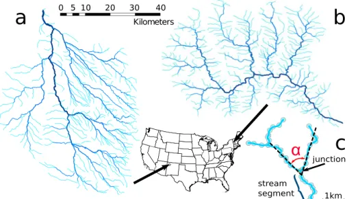
Figure 1. Illustrative examples of drainage networks in (a) arid and (b) humid climates. Planform view of a network on the arid Colorado Plateau in northwestern Arizona (precipitation = 239 mm/yr, potential evapotranspiration = 607 mm/yr), with mean branching angle𝛼 ≈ 47∘ ±2∘(Figure 1a). A network in humid central Vermont (precipitation = 1047 mm/yr, potential evapotranspiration = 513 mm/yr), with𝛼 ≈ 74∘ ±2∘(Figure 1b). (c) The measurement of the branching angle. Each channel segment (blue) between two junctions, or between a channel head and the next junction downstream, is represented by a series of points (light blue). For each junction we calculate the orientation of the orthogonal regression lines (black dashed lines) for the two upstream segments. The angle between the regression lines for the two tributaries defines their branching angle𝛼.
Figure 1 shows drainage networks in two contrasting erosional environments. The network shown in Figure 1a lies in the arid Colorado Plateau in northwestern New Mexico, whereas the network shown in Figure 1b comes from the more humid landscape of central Vermont. One visually obvious difference between the two net-works is that the Vermont netnet-works appear to have distinctly wider junction angles. This visual impression is borne out by measurements (as described below) that reveal that the Vermont network’s mean branching angle is ∼74∘ ± 2∘(mean ±1𝜎 standard error), in contrast to the Colorado Plateau network’s mean branching angle of 47∘ ± 2∘. The networks in Figure 1 suggest that junction angles may be a useful diagnostic tool for characterizing the planform geometry of river networks and in particular that junction angles may vary sys-tematically with climate, potentially reflecting the relative dominance of different erosional processes under different climatic conditions.
2. Analysis
2.1. Data Sources, Drainage Networks, and Junction Angles
To explore whether the geometry of drainage networks generally responds to climatic controls as suggested by Figure 1, we analyzed stream junctions throughout the contiguous United States, as mapped in the NHDPlus Version 2 data set [McKay et al., 2014]. This data set provides the centerline locations and connectiv-ity of river segments spanning the continental U.S. at a resolution of approximately 30 m. Channel slope is also provided for most of the segments. The NHDPlus data set is an enhanced version of the medium-resolution National Hydrography Dataset (NHD), which does not depict channel networks’ smallest tributaries [Benstead
and Leigh, 2012; Fritz et al., 2013]. Thus, our analysis excludes many junctions between small streams but
instead focuses on streams that can be reliably mapped and that have the strongest imprint on the landscape. Our analysis is also necessarily restricted, for reasons of data availability, to the contiguous United States. Digital maps of global stream networks are available but only at much coarser (∼1 km) resolution and thus could only resolve much larger rivers. NHDPlus is the best publicly available channel network data set that cov-ers a large area and, importantly for our purposes, spans a wide range of climatic regimes. Of the nearly one million stream junctions in the data set, roughly 6% can be attributed to distributary junctions (e.g., in deltas), rejoining braided streams, artificial side channels, or canals. We excluded these, leaving 934,207 junctions for analysis.
Figure 2. Mean (a) branching angles and (b) aridity in the contiguous United States, spatially averaged over Hydrologic Unit Code-6 basins of the National Hydrographic data set [McKay et al., 2014]. Mean branching angles become systematically wider as climates become more humid throughout the contiguous United States. (c) Mean branching angle as a function of the aridity index ( = P∕PET, ratio of precipitationPand potential evapotranspiration PET) for all stream junctions (median branching angles obey nearly the same relationship; see Figure S4). Blue and yellow symbols represent the wettest ( ≥ 2) and driest ( ≤ 0.2) extremes of the aridity index. Error bars indicate standard errors, where they are larger than the plotting symbols. (d) The distribution of stream branching angles in the arid tail of the aridity range ( ≤ 0.2). (e) The distribution of stream branching angles in the humid tail of the aridity range ( ≥ 2). Frequency indicates counts normalized by sample size. The dashed line marks the theoretical prediction (72∘) for growth in a (diffusive) groundwater field.
To obtain the branching angles at each junction, we first mapped the NHDPlus stream networks on a con-formal (i.e., angle-preserving) projection for the contiguous United States (Lambert concon-formal cone 102004). From the connectivity attributes in the NHDPlus data set, we identified the stream segments that meet at each junction in the network. Each tributary segment is defined by a series of (x, y) pairs of coordinates connected in the downstream direction. Using these points, we calculated the average orientation of each tributary stream (between each junction, or channel head, and the next junction downstream) by fitting a straight line using orthogonal regression [Samuelson, 1942; Rayner, 1985]. The average orientation of each stream seg-ment is given by the direction of its regression line, which is independent of the actual segseg-ment length. The angle between the fitted lines for each pair of upstream tributaries defines their branching angle, as shown in Figure 1c. This approach measures the angle between the mean directions of the two tributary valleys, rather than the local angle at which the two channels join (which is presumably a less durable feature of the land-scape and more affected by fluctuations like meandering, which strongly depend on the local flow geometry). We also calculated the mean slope at each junction as the average of the NHDPlus slope attribute values of the two tributary stream segments. Finally, we averaged all the junction angles in each HUC6 (Hydrologic Unit Code-6) drainage basin. These basins average 17,000 km2in size and usually contain several thousand
junc-tions. Figure 2a shows a map of these basin-wide averages. Although the standard deviation of the branching angle distribution in each basin is around 25∘, the standard error of the mean branching angle is usually smaller than 2∘. A clear trend emerges: branching angles in the humid eastern U.S. tend to be wider than those in the arid western U.S., with notable exceptions in the humid Pacific Northwest. This spatial pattern suggests that mean junction angles may be correlated with the climatic aridity-humidity continuum.
2.2. Branching Angles and Aridity
To explore the relationship between junction angles and climate, we quantified the climatic conditions at each stream junction using the UN Environment Program’s aridity index = P∕PET [Middleton and Thomas
(Eds.), 1997], where P and PET are the precipitation rate and potential evapotranspiration rate, respectively.
Larger values of are thus associated with more humid climates while smaller values characterize more arid landscapes. We computed at 4 km resolution using precipitation and temperature data from PRISM aver-aged over the period 1900–2012 [PRISM Climate Group, 2012]. Although this 112 year record is short compared to the time scales of river network evolution, we would expect the relative pattern of aridity to persist even as
Geophysical Research Letters
10.1002/2016GL072089
the average climate changes, such that relatively arid sites remain relatively arid, barring large-scale reorga-nization of atmospheric circulation [Riebe et al., 2004]. Thus, we would expect that the overall relative pattern of aridity obtained from the 112 year instrumental record should be representative of longer periods of time, even if the absolute aridity values may differ.
Figure 2b shows values of averaged over the same hydrologic basins that were used to compute mean branching angles in Figure 2a. Comparing the two maps, one immediately sees that wider branching angles tend to occur in more humid regions and that the narrowest average branching angles are found in the dri-est parts of the southwdri-est. We quantified the relationship between aridity and branching angle by delimiting 23 bins on a logarithmic scale of and computing the mean angle of all stream junctions in each bin. The resulting correlation function, which gives the mean angle as a function of the logarithm of the aridity index, is shown in Figure 2c, where the mean angle approaches roughly 72∘ under the most humid conditions (high values of). The most arid regions, by contrast, are characterized by mean junction angles of 45–50∘. Between these two end-member extremes, junction angles increase systematically along the climatic contin-uum from = 0.2 to = 2.0 (i.e., log10 between −0.7 and +0.3). For any given value of , individual
junction angles exhibit considerable variability. Figures 2d and 2e show the distributions of individual junc-tion angles for the arid ( ≤ 0.2) and humid ( ≥ 2) end-members, where the mean values are 47∘ ± 1∘ and 72∘ ± 1∘, respectively, and the standard deviation is approximately 35∘ in each case. Consequently, individual stream junctions’ branching angles only weakly reflect the aridity of the landscape. The unambiguous corre-lation shown in Figure 2c emerges through “big data” aggregation of many junction angle measurements, averaging over measurement and mapping errors, geological heterogeneity, and natural perturbations dur-ing network evolution. Aggregatdur-ing junction angles over large landscape units allows the identification of relationships that would not be revealed from small-sample case studies. For the same reason, however, these relationships should not be interpreted as describing individual junctions or local groups of junctions.
2.3. Signatures of Climate and the Impact of Slope
Erosional signatures of climate are more likely to be expressed in junctions between low-order streams, whereas higher-order junctions are more likely to have been reshaped through time by in-stream flow pro-cesses [Howard, 1971; Pieri, 1984] or catchment reorganization [Willett et al., 2014; Shelef and Hilley, 2014]. As with any branching network, the lowest-order streams comprise most of the junctions in our data set and thus dominate the overall statistics.
To test how branching geometry varies with network hierarchy, we separately analyzed the angle-aridity rela-tion for stream bifurcarela-tions of different Horton-Strahler orders in our network, as shown in Figure 3a. We define a junction of order n as one that is formed where two tributaries of order n join, thus creating a stream of order
n+1 in the downstream direction. For simplicity this definition neglects side branches where lower order
trib-utaries join higher-order streams (because this creates many different combinations of orders), although such side branches comprise a substantial fraction of the complete data set shown in Figure 2c. As Figure 3a shows, all orders exhibit increases in branching angle with increasing aridity index (that is, with increasing climatic humidity) independent of side branches of lower order entering major streams. One might expect the rela-tionship between branching angles and aridity to become weaker for higher-order junctions due to channel migration and catchment reorganization during the evolution of the network [Willett et al., 2014; Shelef and
Hilley, 2014]. Furthermore, with increasing stream order and flow discharge, in-stream fluvial processes may
become increasingly important in shaping the branching structure. Several theories for the branching angles of river junctions have been suggested, such as the geometric model [Howard, 1971; Pieri, 1984], the mini-mum work model [Howard, 1971, 1990; Serres and Roy, 1990], or the momentum balance model [Mosley, 1976]. These models are based on geometric factors such as longitudinal profile concavity or slope and water dis-charge and aim to predict the local angles at which two river segments should meet rather than the branching angle of the two upstream tributary valleys (supporting information).
The tendency of higher-order streams to branch at wider angles suggests not only a possible effect of drainage reorganization but also a dependence on topographic gradients. Lower order channels are typically located in the headwaters of the stream network and thus are typically steeper than higher-order, lower gradient channels, as shown in Figure 3b. Therefore, the narrowing of junction angles at lower orders may partly reflect a narrowing of junction angles with increasing channel gradients (Figures 3a and 3c).
One would expect flows (including subsurface flows) in steeper landscapes to be oriented more strongly along the downslope gradient vector of the surrounding terrain. Thus, all else equal, we would expect steeper
Figure 3. (a) Relationships between mean branching angle and aridity for junctions of different Horton-Strahler orders. (b) For each order, the mean channel gradient decreases by typically a factor of 2. (c) Decreases in mean branching angles with increasing channel gradient (here calculated as the mean of the gradients of each junction’s two tributaries), for humid ( ≥ 2), intermediate (0.2 < < 2), and arid ( ≤ 0.2) climates. (d) Increases in mean branching angles with increasing humidity, for shallow (s≤ 0.003), intermediate (0.003 < s < 0.03), and steep (s≥ 0.03) channel gradients. Error bars show standard errors, where they are larger than the plotting symbols.
streams to have narrower branching angles, reflecting the greater slope-parallel component of the gravita-tional forces acting on the flow. As Figure 3c shows, branching angles are indeed systematically narrower in steeper stream networks, narrowing on average by 10∘ for each factor-of-10 increase in tributary gradi-ents. However, regardless of gradient, mean junction angles still become systematically wider with increasing humidity (Figure 3d).
Figure 4. Mean branching angle for each HUC 6 basin in the contiguous United States is more strongly correlated (a) with mean climatic aridity than (b) with mean channel gradient or (c) with stream network concavity.
Geophysical Research Letters
10.1002/2016GL072089
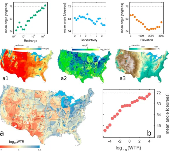
Figure 5. Relationships between mean junction angles and the water table ratio and its three main components. The water table ratio (WTR), calculated following Gleeson et al. [2011], describes the degree to which groundwater aquifers are connected to the surface (high WTR, blue) or disconnected from it (low WTR, red). (a) Maps of WTR and its three main components: annual recharge [Wolock and McCabe, 1999], aquifer hydraulic conductivity [Gleeson et al., 2014], and surface elevation [Survey, 2014], along with plots of mean junction angles as functions of these three components. (b) Systematic increase in mean junction angle with increasing WTR. Error bars show standard errors, where they are larger than the plotting symbols.
For similar slopes our analysis reveals a roughly 20∘ shift in mean junction angle between arid and humid end-member landscapes (Figures 3c and 3d). This shift, which persists over the entire range in slope, could potentially arise from the dominance of different channel-forming processes in the wet and dry end-member regimes [Horton, 1945; Montgomery and Dietrich, 1992; Kirkby and Chorley, 1967; Dunne, 1969, 1978, 1990;
Molnar, 2004; Molnar et al., 2006]. The histograms in Figures 3c and 3d show that the tails of the aridity and
slope distributions represent only a small fraction of stream junctions in the data set. Nonetheless, their abso-lute numbers are considerable, given the nearly one million junctions in the data set, and they are important for defining the end-member extremes.
Several simulation models for drainage basin evolution suggest that branching angles are largely controlled by channel slope or by stream network concavity, which is defined by the exponent𝜃 in the slope-area relation
S = kA𝜃[Howard, 1994; Sun et al., 1994; Sólyom and Tucker, 2007]. To test these hypotheses we calculated the mean slopes and concavity exponent𝜃 for all HUC-6 basins in the contiguous United States and compared their correlations with branching angles to that of aridity. Figure 4 shows that the correlation of aridity with mean branching angles is much stronger than that of mean channel slope or concavity, which have been proposed as major controls on stream network geometry.
2.4. Water Table Ratio and Branching Angles
A further clue suggesting a mechanistic linkage between climate, channelization processes, and junction angles arises from the analysis of the water table ratio [Haitjema and Mitchell-Bruker, 2005; Gleeson et al., 2011]. The water table ratio (WTR) is a dimensionless number describing how closely a groundwater aquifer is coupled to surface processes [Haitjema and Mitchell-Bruker, 2005]. The water table ratio is a combination of groundwater recharge R, hydraulic conductivity𝜅, and surface elevation d [Gleeson et al., 2011], as shown in Figure 5 for the continental United States.
As Figure 5a shows, mean junction angles increase more or less systematically with recharge but do not show a clear relationship with either conductivity or elevation. However, when these three measures are combined to form the WTR, they exhibit a strong and systematic relationship with mean junction angles (Figure 5b). Wider junction angles are found where the WTR predicts a strong coupling between surface and subsurface flows, and in locations with the largest WTRs, mean junction angles approach 72∘, the theoretically expected value for networks formed by groundwater-driven erosion [Devauchelle et al., 2012]. Conversely, landscapes with decoupled aquifers (i.e., small WTRs) show much smaller mean branching angles.
3. Discussion
The continental U.S., like any land mass, does not present a perfect natural experiment; all combinations of aridity and landscape characteristics are not equally probable. Thus, for example, much of the landscape char-acterized by 0.1 < log10 < 0 lies in the Great Plains, between the Mississippi and the Rocky Mountains, where a broad regional gradient from west to east creates many parallel drainages and thus contributes to the narrowing of the junction angles. This may account for the anomalously low mean branching angle in the corresponding log10 bin in Figure 2. More generally, the intermountain West is both steep and arid, and
thus one might question whether the narrow mean junction angles that characterize this landscape are due to its climate or its topography. The answer is that both factors matter, but as Figures 3c and 3d show, there is a clear trend toward wider junction angles with increasing humidity, even when controlled for differences in topographic gradient.
The general trend toward wider junction angles in more humid landscapes can be hypothesized to reflect a shift in relative dominance among channel-forming geomorphic processes along climate gradients. Infiltra-tion of precipitaInfiltra-tion into the ground, and thus the potential for diffusive geomorphic transport processes, such as groundwater flows, is more prevalent in humid landscapes than in arid ones [Kirkby and Chorley, 1967; Dunne, 1969]. Conversely, arid and semiarid landscapes are more likely to be shaped by erosion due to surface runoff, because greater aridity is associated with decoupled groundwater aquifers, more episodic precipitation [Molnar, 2004; Molnar et al., 2006], and sparser vegetation, which is less effective in inhibiting surface erosion. As surface erosion is more likely to be oriented along the topographic gradient, we would expect junction angles to generally be narrower where surface runoff is more common. This expectation is borne out by Figures 2a–2e, which show a general trend toward narrower junction angles in more arid cli-mates and wider junction angles in more humid clicli-mates. The same trend is observed not only across all junctions as a whole (Figure 2) but also for individual orders and specific ranges of topographic gradients (Figures 3c and 3d).
The hypothesis that branching angles generally reflect the relative dominance of the underlying channeliza-tion processes is supported by recent theoretical studies which show that network growth in groundwater fields should favor a particular angle—2𝜋∕5 or 72∘ —at which valley heads branch [Devauchelle et al., 2012;
Petroff et al., 2013]. This result requires only that valley heads advance in the direction that captures a
diffusive flux, such as groundwater flow. However, it is unclear how strictly this theoretical result should be applied to the long time scales of river basin evolution and to the large spatial scales examined in our study.
For branching angles shaped by surface and near-surface flows, one would expect these flows to be more focused in a slope-parallel direction; thus, the prevailing topographic gradient would tend to give nearby flows more similar orientations and thus narrower junction angles. Consistent with this hypothesis, the mean branching angles in our data set are considerably smaller in arid landscapes which are expected to be shaped by overland flow and increase toward the theoretically expected value of 72∘ in the most humid landscapes (and at low gradients and low stream orders), as shown in Figures 2 and 3.
Geophysical Research Letters
10.1002/2016GL072089
These observations suggest that the trend toward wider mean branching angles in more humid landscapes may result from an increased relative importance of diffusive processes close to the channel heads. The analy-sis of the water table ratio (Figure 5) additionally supports this interpretation. With increasing order the mean junction angle shifts to larger values, suggesting an increased influence of drainage reorganization shaped by in-stream flow processes [Howard, 1971, 1990].
The systematic variation of branching angle with climate and erosional mechanisms may provide a basis for reconstructing ancient climates and identifying erosional mechanisms from relict landscapes, including those on Mars. Globally, about two thirds of the water flowing into rivers is thought to be derived from subsurface flows [Dirmeyer et al., 2006; Oki and Kanae, 2006]. Our analysis suggests that the relative dominance of subsur-face flows, or any other mechanism of diffusive network growth, may leave a characteristic geometric imprint in the branching geometry of stream networks. Thus, our results suggest that climate has a significant impact on stream junction angles, leaving a characteristic watermark on much of the Earth’s surface environment.
References
Benstead, J. P., and D. S. Leigh (2012), An expanded role for river networks, Nat. Geosci., 5(10), 678–679.
Devauchelle, O., A. P. Petroff, H. F. Seybold, and D. H. Rothman (2012), Ramification of stream networks, Proc. Natl. Acad. Sci. U.S.A., 109(51), 20,832–20,836.
Dietrich, W. E., D. G. Bellugi, L. S. Sklar, J. D. Stock, A. M. Heimsath, and J. J. Roering (2003), Geomorphic transport laws for predicting landscape form and dynamics, in Prediction in Geomorphology, edited by P. R. Wilcock and R. M. Iverson, pp. 103–132, AGU, Washington, D. C.
Dirmeyer, P. A., X. Gao, M. Zhao, Z. Guo, T. Oki, and N. Hanasaki (2006), GSWP-2: Multimodel analysis and implications for our perception of the land surface, Bull. Am. Meteorol. Soc., 87(10), 1381–1397.
Dunne, T. (1969), Runoff production in a humid area, PhD thesis, Johns Hopkins Univ., Baltimore, Md.also published as U.S. Department of Agriculture Report ARS, 4–160, 1970.
Dunne, T. (1978), Field studies of hillslope flow processes, in Hillslope Hydrology, edited by M. J. Kirkby, pp. 227–293, Wiley, Chichester, U. K. Dunne, T. (1990), Hydrology, mechanics, and geomorphic implications of erosion by subsurface flow, in Groundwater Geomorphology:
The Role of Subsurface Water in Earth-Surface Processes and Landforms, Geol. Soc. Am. Spec. Pap., vol. 252, edited by C. G. Higgins
and D. R. Coates, pp. 1–28, Geol. Soc. of Am., Boulder, Colo.
Ferrier, K. L., J. W. Kirchner, and R. C. Finkel (2012), Weak influences of climate and mineral supply rates on chemical erosion rates: Measurements along two altitudinal transects in the Idaho Batholith, J. Geophys. Res., 117, F02026, doi:10.1029/2011JF002231. Ferrier, K. L., K. L. Huppert, and J. T. Perron (2013), Climatic control of bedrock river incision, Nature, 496(7444), 206–209.
Fritz, K. M., E. Hagenbuch, E. D’Amico, M. Reif, P. J. Wigington, S. G. Leibowitz, R. L. Comeleo, J. L. Ebersole, and T. Nadeau (2013), Comparing the extent and permanence of headwater streams from two field surveys to values from hydrographic databases and maps, J. Am. Water
Resour. Assoc., 49(4), 867–882.
Gleeson, T., L. Smith, N. Moosdorf, J. Hartmann, H. H. Dürr, A. H. Manning, L. van Beek, and A. M. Jellinek (2011), Mapping permeability over the surface of the Earth, Geophys. Res. Lett., 38, L02401, doi:10.1029/2010GL045565.
Gleeson, T., N. Moosdorf, J. Hartmann, and L. P. H. van Beek (2014), A glimpse beneath Earth’s surface: Global hydrogeology maps (GLHYMPS) of permeability and porosity, Geophys. Res. Lett., 41, 3891–3898, doi:10.1002/2014GL059856.
Haitjema, H. M., and S. Mitchell-Bruker (2005), Are water tables a subdued replica of the topography?, Ground Water, 43(6), 781–786. Horton, R. E. (1932), Drainage-basin characteristics, Eos Trans. AGU, 13(1), 350–361.
Horton, R. E. (1945), Erosional development of streams and their drainage basins: Hydrophysical approach to quantitative morphology,
Geol. Soc. Am. Bull., 56, 275–370.
Howard, A. D. (1971), Optimal angles of stream junction: Geometric, stability to capture, and minimum power criteria, Water Resour. Res.,
7(4), 863–873.
Howard, A. D. (1990), Theoretical model of optimal drainage networks, Water Resour. Res., 26, 2107–2117. Howard, A. D. (1994), A detachment-limited model of drainage basin evolution, Water Resour. Res., 30, 2261–2285. Kirkby, M. J., and R. J. Chorley (1967), Thoroughflow, overland flow and erosion, Bull. Int. Assoc. Sci. Hydrol., 12(3), 5–21. Lubowe, J. K. (1964), Stream junction angles in the dendritic drainage pattern, Am. J. Sci., 262(3), 325–339.
Mars Channel Working Group (1983), Channels and valleys on Mars, Geol. Soc. Am. Bull., 94(9), 1035–1054. McKay, L., T. Bondelid, T. Dewald, A. Rea, R. Moore, and J. Johnston (2014), NHDPlus version 2: User guide.
[Available at http://www.horizon-systems.com/NHDPlus/.]
Middleton, N., and D. Thomas (Eds.) (1997), World Atlas of Desertification, 2nd ed., Arnold Hodder Headline, PLC, London.
Molnar, P. (2004), Late Cenozoic increase in accumulation rates of terrestrial sediment: How might climate change have affected erosion rates?, Annu. Rev. Earth Planet. Sci., 32, 67–89.
Molnar, P., R. S. Anderson, G. Kier, and J. Rose (2006), Relationships among probability distributions of stream discharges in floods, climate, bed load transport, and river incision, J. Geophys. Res., 111, F02001, doi:10.1029/2005JF000310.
Montgomery, D. R., and W. E. Dietrich (1992), Channel initiation and the problem of landscape scale, Science, 255(5046), 826–830. Mosley, P. A. (1976), An experimental study of channel confluences, J. Geol., 84(5), 535–562.
Oki, T., and S. Kanae (2006), Global hydrological cycles and world water resources, Science, 313(5790), 1068–1072.
Pelletier, J. D., and C. Rasmussen (2009), Quantifying the climatic and tectonic controls on hillslope steepness and erosion rate, Lithosphere,
1(2), 73–80.
Perron, J. T., P. W. Richardson, K. L. Ferrier, and M. Lapôtre (2012), The root of branching river networks, Nature, 492(7427), 100–103. Petroff, A. P., O. Devauchelle, H. Seybold, and D. H. Rothman (2013), Bifurcation dynamics of natural drainage networks, Philos. Trans. R. Soc.
A, 371(2004), 20120365.
Pieri, D. C. (1980), Martian valleys—Morphology, distribution, age, and origin, Science, 210(4472), 895–897. Pieri, D. C. (1984), Junction angles in drainage networks, J. Geophys. Res., 89(B8), 6878–6884.
PRISM Climate Group (2012), Oregon State University. [Available at http://prism.oregonstate.edu.]
Rayner, J. M. V. (1985), Linear relations in biomechanics: The statistics of scaling functions, J. Zool., Lond. (A), 206, 415–439.
Acknowledgments
H.J.S. and D.H.R. designed the research, formulated the aridity-angle hypothesis, and analyzed data. J.W.K. analyzed data. All authors contributed to the writing of the manuscript. H.J.S. thanks Daniel Sheehan from MIT’s GIS lab for technical support handling the GIS data. This material is partly based upon work supported by the U.S. Department of Energy, Office of Science, Office of Basic Energy Sci-ences, Chemical SciSci-ences, GeosciSci-ences, and Biosciences Division under award FG02-99ER15004. This analysis is based on publically available data which can be downloaded from PRISM (http://prism.oregonstate.edu) or NHDPlus (http://www.
horizon-systems.com/NHDPlus/). A table with branching angle,x,y
coordinates of each junction, and the aridity value attributed to this junction is provided as supporting information.
Riebe, C. S., J. W. Kirchner, and R. C. Finkel (2004), Erosional and climatic effects on long-term chemical weathering rates in granitic landscapes spanning diverse climate regimes, Earth Planet. Sci. Lett., 224(3), 547–562.
Rodríguez-Iturbe, I., and A. Rinaldo (2001), Fractal River Basins: Chance and Self-Organization, Cambridge Univ. Press, Cambridge, U. K. Roy, A. G. (1983), Optimal angular geometry models of river branching, Geog. Anal., 15(2), 87–96.
Samuelson, P. A. (1942), A note on alternative regressions, Econometrica, 10(1), 80–83.
Serres, B., and A. G. Roy (1990), Flow direction and branching geometry at junctions in dendritic river networks, Prof. Geogr., 42(2), 194–201. Shelef, E., and G. E. Hilley (2014), Symmetry, randomness, and process in the structure of branched channel networks, Geophys. Res. Lett., 41,
3485–3493, doi:10.1002/2014GL059816.
Sólyom, P. B., and G. E. Tucker (2007), The importance of the catchment area-length relationship in governing non-steady state hydrology, optimal junction angles and drainage network pattern, Geomorphology, 88(1), 84–108.
Sun, T., P. Meakin, and T. Jøssang (1994), The topography of optimal drainage basins, Water Resour. Res., 30(9), 2599–2610. Survey, U. G. (2014), National elevation dataset. [Available at http://ned.usgs.gov/.]
Tomasko, M. G., et al. (2005), Rain, winds and haze during the Huygens probe’s descent to Titan’s surface, Nature, 438(7069), 765–778. Tucker, G. E., and R. L. Bras (1998), Hillslope processes, drainage density, and landscape morphology, Water Resour. Res., 34(10), 2751–2764. Whipple, K. X. (2004), Bedrock rivers and the geomorphology of active orogens, Annu. Rev. Earth Planet. Sci., 32, 151–185.
Whipple, K. X., and G. E. Tucker (1999), Dynamics of the stream-power river incision model: Implications for height limits of mountain ranges, landscape response timescales, and research needs, J. Geophys. Res., 104(B8), 17,661–17,674.
Willett, S. D., S. W. McCoy, J. T. Perron, L. Goren, and C. Chen (2014), Dynamic reorganization of river basins, Science, 343(6175), 1248765, doi:10.1126/science.1248765.
Wolock, D. M., and G. J. McCabe (1999), Explaining spatial variability in mean annual runoff in the conterminous United States, Clim. Res.,
11(2), 149–159.
Zanardo, S., I. Zaliapin, and E. Foufoula-Georgiou (2014), Are American rivers Tokunaga self-similar? New results on fluvial network topology and its climatic dependence, J. Geophys. Res. Earth Surf., 118, 166–183, doi:10.1029/2012JF002392.
Zaprowski, B., F. J. Pazzaglia, and E. B. Evenson (2005), Climatic influences on profile concavity and river incision, J. Geophys. Res., 110, F03004, doi:10.1029/2004JF000138.
![Figure 2. Mean (a) branching angles and (b) aridity in the contiguous United States, spatially averaged over Hydrologic Unit Code-6 basins of the National Hydrographic data set [McKay et al., 2014]](https://thumb-eu.123doks.com/thumbv2/123doknet/14332167.498335/4.918.134.786.138.459/figure-branching-contiguous-spatially-averaged-hydrologic-national-hydrographic.webp)

![[PDF] Interface graphique java : dessin guide de formation avec exemples | Cours java](data:image/gif;base64,R0lGODlhAQABAIAAAP///wAAACH5BAEAAAAALAAAAAABAAEAAAICRAEAOw==)