Publisher’s version / Version de l'éditeur:
Journal of Glaciology, 3, 22, pp. 133-141, 1957-10-01
READ THESE TERMS AND CONDITIONS CAREFULLY BEFORE USING THIS WEBSITE. https://nrc-publications.canada.ca/eng/copyright
Vous avez des questions? Nous pouvons vous aider. Pour communiquer directement avec un auteur, consultez la
première page de la revue dans laquelle son article a été publié afin de trouver ses coordonnées. Si vous n’arrivez pas à les repérer, communiquez avec nous à [email protected].
Questions? Contact the NRC Publications Archive team at
[email protected]. If you wish to email the authors directly, please see the first page of the publication for their contact information.
NRC Publications Archive
Archives des publications du CNRC
This publication could be one of several versions: author’s original, accepted manuscript or the publisher’s version. / La version de cette publication peut être l’une des suivantes : la version prépublication de l’auteur, la version acceptée du manuscrit ou la version de l’éditeur.
Access and use of this website and the material on it are subject to the Terms and Conditions set forth at
Observations on breakup in the Mackenzie River and its Delta in 1954
Brown, R. J. E.
https://publications-cnrc.canada.ca/fra/droits
L’accès à ce site Web et l’utilisation de son contenu sont assujettis aux conditions présentées dans le site LISEZ CES CONDITIONS ATTENTIVEMENT AVANT D’UTILISER CE SITE WEB.
NRC Publications Record / Notice d'Archives des publications de CNRC:
https://nrc-publications.canada.ca/eng/view/object/?id=79a1f06f-1912-4d23-8026-9073306af44b https://publications-cnrc.canada.ca/fra/voir/objet/?id=79a1f06f-1912-4d23-8026-9073306af44bSer
TH1
N21r2
no.
45
c.2
BEPGNATIONAL
RESEARCH
COUNCIL
C A N A D A
BUILDING RESEARCH
r=]
<
NAYIONAL R E S E A R C H COUNCILI
--..
OBSERVATIONS ON
BREAK
-
UP
IN THE MACKENZIE RIVER
N R C 4 4 6 1
AND ITS DELTA IN
1954
BY R. J. E BROWN R E P R I N T E D F R O M J O U R N A L O F G L A C I O L O G Y V O L . 3 . N O . 22. O C T O B E R 1 9 5 7 . P. 133 . 141 R E S E A R C H P A P E R N O . 4 5 O F T H E
DIVISION O F BUILDING RESEARCH
OTTAWA
OCTOBER 1957
This p u b l i c a t i o n
i s
being d i s t r i b u t e d
by
t h e Division of Building Research of t h e National
Research Council a s
a c o n t r i b u t i o n towards b e t t e r
b u i l d i n g i n Canada.
It should not be reproduced
i n whole o r i n p a r t , without permission o f t h e o r i -
g i n a l publisher,
The Division would be glad t o
be
of a s s i s t a n c e i n o b t a i n i n g such permission,
Fublications of t h e Division of Building
Research may be obtained by mailing t h e a p p r o p r i a t e
remittance,
( a Dank, Express, o r Post Office Money
Order o r a cheque made payable a t p a r i n Ottawa,
t o t h e Receiver General of Canada, c r e d i t National
Research Council) t o t h e N a t i o r a l Research Council,
Ottawa.
Stamps a r e not acceptable.
A
coupon system has been frrtroduced
t o
make payments f o r publicat ions r e l a t i v e l y simple.
Coupons a r e a v a i l a b l e i n denominations of
5,
25,
and
cents,
and may
be
obtained
by
making a r e -
mittance a s i n d i c a t e d above.
These coupons may be
used f o r t h e purchase of
a l l National Research
Council p u b l i c a t i o n s i n c l u d i n g s p e c i f i c a t i o n s o f
t h e Canadian Government S p e c i f i c a t i o n s Board,
A ~ A L Y
ZED
Reprinted front Journal of Glaciology, Vol. 3, N o . 22, Octobei. 1957, pages 13L?-141 O B S E R V A T I O N S O N B R E A K - U P I N T H E M A C I C E N Z I E R I V E R
I33
O B S E R V A T I O N S O N B R E A K - U P I N T H E M A C K E N Z I E
R I V E R A N D I T S D E L T A I N 1 9 5 4 *
(Research Officer, Permafrost Section, Division of Building Research, National Research Council of Canada)
ABSTRACT. Winter conditions on the Mackenzie River a n d Delta in North-west Canada are discussed. Daily observations during the break-up period of the Mackenzie River for 19 jq are recorded, as well as a general record of the break-up of ice in the delta and detailed observations of the break-up in one of the main channels.
RrisuhrP. L'article concerne les conditions climatologiques d'hiver au Nord-Ouest d u Canada dans la region d u Aeuve Mackenzie et d e son delta. On y relate les observations journalieres effectuCes pendant la periode d e degel d u Mackenzie en 1954, on y dCcrit Cgalement dans les grandes lignes la dlbicle d u delta et on y rapporte quelques observations dCtaillCzs s u r le dlgel de l'un des principaux chenaux.
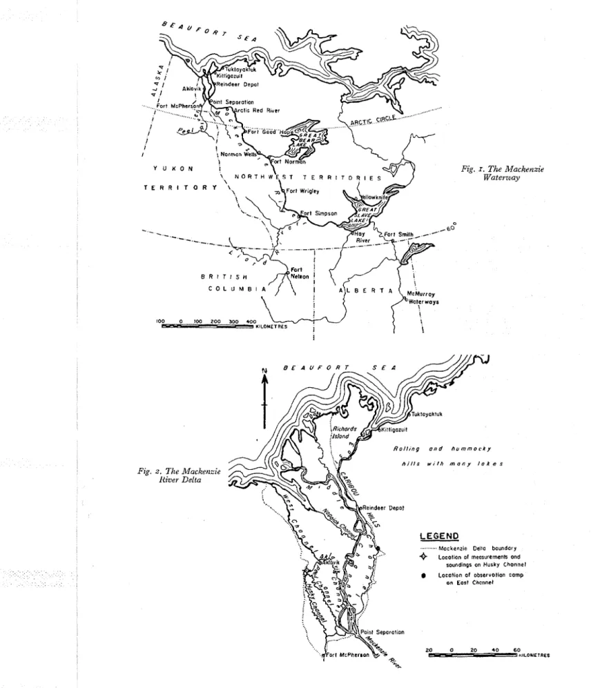
T h e Mackenzie River system ranks as one of the eight great river systems of the world (Fig. I ,
p. 135). On the North American continent it is exceeded in length and drainage area only by the WIississippi River'. T h e total area of its basin is approximately 1,760,000 km.2 or somewhat more than one-fifth of the area of Canada including some of the largest freshwater lakes in the world. Although over 2550 km. in length from Waterways, Alberta, to the Arctic Coast, the entire water- way is navigable except for a series of rapids on the Slave River between Fort Fitzgerald and Fort Smith.
T h e Mackenzie Delta is a maze of meandering channels and small stagnant lakes covering an area of more than 13,000 km.2 (Fig. 2, p. 135). T h e delta begins near Point Separation, where the river divides into three main channels: the Middle Channel averaging 2.4 km. in width ; the East Channel, approximately 150 m. wide down to Reindeer Depot and then widening to over 0.8 km. ; and the Peel Channel with an average width of approximately 150 m. which becomes the West Channel with an average approximate width of 0-8 km. Between these main channels are thousands of interconnecting streams varying in width from IOO m. to only a few metres.
T h e river and its delta are icebound nearly eight months of the year. During this period, all supplies for river settlements must be brought in by aircraft.
Freeze-up and break-up each last approximately six weeks and are important periods especially to those in the delta where there are no landing strips and the only communication is by float- and ski-equipped aircraft. During these transition periods, therefore, settlements in the delta are completely isolated.
T h e break-up period lasts from the first melting of the snow on the ice to the clearing of ice in the river and delta. T h e significant period for aircraft is when the ice is unsafe for ski-equipped aircraft and there is not sufficient open water for float-equipped aircraft to operate. T h e time the main body of river ice first breaks is sometimes given as the time of break-up although often it is still quite solid and may remain several days before moving downstream.
Ja7izra~y Air Temperatures 071 the River
T h e Mackenzie waterway extends through 16' of latitude, and therefore there is a marked gradation in the temperatureregime from south to north'.
* T h i s paper is a contribution from the Division of Building Research. National Research Council of Canada and is published with the approval of the Director.
I 3 4
J O U R N A L O F G L A C I O L O G YThe mean January daily temperature grades from -23" C. at Waterways to -29" C. at Fort Norman. In the vicinity of Fort Good Hope it is approximately -32" C. ; and in the delta, approxi- mately -29" C. From Waterways to Norman Wells, the mean January daily minimum temperature ranges from -29" C. to -34" C. The gradation in mean January daily maximum temperature ranges from -18" C. at Waterways to -23" C. at Fort Simpson. From Fort Simpson to the A~ctic Coast it is fairly constant at approximately -24" C.
Winter Air Temperatures in the Delta
The delta, 320 km. north of the Arctic Circle, receives no sunlight from the end of November until the middle of January.
The maximum air temperature recorded at Aklavik remained below oO C. from 13 October 1953 to z May 1954 except for two short periods at the end of March when it rose to 1.7" C. and 2.8" C. (Fig. 3, p. 137). Several very cold days occurred at the beginning of January 1954 with a low of -50" C. recorded on 5 January. Throughout the winter the average mean daily temperature was approximately -25" C.
Conditions in the Delta Channek;
By the end of the winter, ice in the channels is generally more than I m. thick, overlain by snow varying in depth from a few centimetres to several metres. The ice is strong enough to sup- port snowmobiles and other vehicles although areas of thin ice sometimes occur at the junctions of channels.
The following data, taken 15 April 1954 on the Husky Channel 3 km. upstream from its junction with the Peel Channel (Fig. z), might be considered typical for the channels in the delta ;
23 cm. of snow covered the ice in the middle of the channel (snow cover consisted of 2.5 cm. of powder snow over 20.5 cm. of crystallized ice particles) ; ice in the channel had attained its maxi- mum thickness, approximately 1-22 m. ; the water, at its lowest level, measured 5-54 m. near the
middle of the channel and was clear, with no evidence of current.
The break-up begins at the source and progresses northward downstream. The ice near the mouth, which moves out last, forms a barrier and causes severe ice jams and floods.
Break-up starts at Great Slave Lake and progresses slowly, usually reaching each settlement at about the same time each year. I n 1954 break-up occurred a week later than usual because air temperatures were below average during April and May. T h e Liard River, which empties into the Mackenzie River at Fort Simpson, usually breaks before the Mackenzie. T h e Mackenzie, between Great Slave Lake and Fort Simpson, breaks and clears of ice several weeks before the ice in Great Slave Lake.
I n 1954 observations on the break-up of the Mackenzie River were taken in connexion with an extensive survey of the whole delta for the relocation of the northern settlement of Aklavik. Detailed knowledge of the break-up of the river was needed in connexion with the design of the necessary transportation facilities at the proposed new site for Aklavik.
Daily observations of break-up were made by the Royal Canadian Corps of Signals in the settlements on the Mackenzie River (Table I). Wireless reports from the signal stations recorded the following observations :
Fig. z. The Mackenzie River Delta
Fig.
0
.60
I . Waterzuay Tlze Macketzzie
R o l l i n g a n d h u m m o c k y h i l l s w i t h m a n y l o k e s
LEGEND
.. . . .. . Mockenzie Della boundary
4 Locotion of rneosurernenh ond soundings on Husky Chonnel Locotion of observotion comp
on Eost Channel
JOURNAL OF GLACIOLOGY
Station Latitude of Approxirrrate Date
Station of Break-up
Liard River (near mouth) May 14
Fort Simpson 62" May 19
Fort Wrigley 63' May 20
Fort Norman 65° May 21
Bear River (near mouth) May 28
Norman Wells 6 j" May 24
Fort Good Hope 66" 30' May 22
Arctic Red River 67O 30' June I
Fort McPherson 67' 30' May 25
Aklavik 69: June 5
East Channel (observation post) 69 May 29
19 1?112y
Fort Simpson. Liard River broke 14 May and is almost free of ice. Mackenzie River, upstream, unbroken.
Fort Wrigley. Ice rose 1.5 m. and is still rising. Water running free on both sides.
Fort Norman. Shore leads on both sides 30 m. wide, with water rising at normal rate, but main body solid. Break-up 5 or 6 days behind normal.
ATorman Wells. Ice holding but becoming soggy on top.
20 May
Fort Wrigley. Main ice body broke and moved 180 m. Water level has risen 2.4 m. and small ice pans are moving in the shore leads.
F o ~ t No~man. Water level rising 2.5 cm./hr.
21 May
Fort Wj.igley. Small pans moving in the shore leads. Water level dropped 2; cm. in afternoon.
Fovt Norman. Main ice body broke in morning with water level slightly above normal. Ice moved for a few hours, then stopped. Bear River still solid.
22 il4ay
F o ~ t W~igley. Main ice body moved 135 m. at 22.00 hr.
Fort Novman. Water level rising slowly. Large opening in ice at mouth of Bear River but ice solid in that river.
Fort Good Hope. Ice body broke in afternoon and moved I mile.
Arctic Red River. Water level rising slowly. Fort 1VIcPherson. Water level high but current slow. 23 '?lay
Fort Norman. Ice moved for first time since 21 May and water level began rising again.
Normall Wells. Main ice body broke at 07.35 hr.
Fort Wrigley. Main ice body broken u p into quickly moving pans. Norman Wells. Main ice body breaking into quickly moving pans. 25 May
Fort McPherson. Main ice body broke at 21.00 hr. and jammed at 22.30 hr. Water level rising
N rn
$ 3 3 3
$
a x $ ;
" Q aZ *
k g"
b q s
k % $ P%
,+ y ? H O-
O C Dz
F;
..,
E. D 32 2 "
$ . R 9
2
- 0 tJg
a
s.
2.
g B g $
rn 0 rtc z E . 5
' r O r': E E& ? "
ZJ
5 . 3
ZJ
g"9T
g -$ 3 ~ 5 -
PI-.
rt2 %
8 2
~ 3 . &-:2
5 2 4
8 z . E ' r r n E.3
6. +!$
P 8
9 G;
i;'z
E os Y i3- H E I G H T ( M E T R E S ) W2
0:
0k
0 0 W-
N W e UI 0 ) (I)-
-
-
N A I R T E M P E R A T U R E S ( D E G R E E S C E N T I G R A D E )1 3 ~ J O U R N A L O F G L A C I O L O G Y 28 May
Fort Norman. Few ice pans remain. River now open for navigation. Water level has dropped 25 cm. since 27 May.
Norman Wells. River clear of ice except for pieces breaking off the shore.
Arctic Red River. No change in ice conditions since 27 May. Water level rising 2.5 cm./hr. 29 May
Fort Norman. Mackenzie River clear of ice. River ice body broke during night. 30 May
Fort Good Hope. Ice pans running fast. Ice jammed 30 m. high at mouth of Ramparts.
I June
Arctic Red River. Main ice body broke at 13.00 hr.
2 j%ne
Arctic Red Rizer. River almost clear of ice.
By z June, the ice had cleared from the Mackenzie River although ice pans were coming in from many tributaries.
BREAK-UP
IN THE DELTA OF THE MACKENZIE RIVERThe first evidence of break-up is the melting of snow on the ice near the shore. This begins early in May when the air temperature rises above oO C. during the day. Melting snow from the mountains causes the river to rise in flood and as the water level rises, the ice in the channels is bowed up in the centre and held at the sides by the anchor ice. As the water continues to rise it breaks through in places, submerging the anchor ice which still holds firm under the water. Eventually the anchor ice breaks under increasing pressure and floats to the surface in the form of small pans. These are carried downstream in the shore leads leaving a continuous band of ice in the centres of the channels (Fig. 5, p. 141).
Toward the end of May, the main body of ice in the channels breaks into large pans (Fig. 6, p. 141). As the snow melts, the solid transparent ice changes to candle or honeycomb ice composed of long crystals oriented normal to the surface. Spaces between crystals are usually filled with water and the ice appears dark.
As the water level rises and the current increases, the ice cakes are ground against one another and the shore. Sharp bends in the channels cause jams and the ice may pile up for several kilo- metres. Just below Point Separation, several large islands hinder ice movements down the Middle and East Channels. In 1954, ice was funnelled into the Peel Channel and the west side of the delta several days before it moved into the Middle and East Channels. Jams often pile up on shore to a height of several metres, occasionally damaging trapper's cabins and pushing over small trees.
The water level reaches its peak at this time and then begins to recede. Within a few days the main body of ice, now broken and candled, moves downstream.
The end of the ice is marked by an accumulation of driftwood and other debris which has been picked up by the flood water. Eventually it is either stranded on the banks of channels or carried out to the open sea. Cakes of ice, covered with silt and stranded on shore, have been seen in July. Early in June 1954, random observations were made by helicopter over various parts of the delta. During this period the water level reached the highest mark and the main ice bodies in the channels broke up and moved downstream.
O B S E R V A T I O N S O N B R E A K - U P I N T H E M A C K E N Z I E R I V E R
I39
z June
Low islands in the Middle Channel submerged and heavy ice running; channel jammed with pans at mouth of Aklavik Channel. Aklavik Channel open 8 km. down from its junction with the Middle Channel but ice not moving below this.
On Peel Channel, ice solid at Alkavik but broken up-stream above mouth of Husky Channel. Broken ice and driftwood formed jam at mouth of Phillip's Channel. Indian village at mouth of Peel Channel surrounded by water.
Ice on East Channel at junction with Middle Channel jammed solidly; ice had risen to . top of bank, 6 m. above winter low water level ; here highest flood level since 1938 reached at midnight I June.
3 Jz~ne
Ice jammed in Middle Channel at Point Separation. Aklavik Channel plugged with broken cakes of ice near junction with Middle Channel (Fig. 7, p. 141).
On Peel Channel at Aklavik large pans moving in shore lead ; Government dock under water; current about 8 krn./hr. Up-stream heavy ice running at many points and some pans going into tributary channels. At Indian village, water level dropped nearly I m. although
further down-stream, rises in water level up to 15 cm. reported in a period of 6 hr. I n contrast to west side of delta, ice in East Channel and tributaries had not moved since I June.
4 Jane
Ice conditions same as 3 June in Middle and Aklavik Channels. River ice broken but holding fast with occasional open stretches.
On Peel Channel, heavy ice at mouth of Husky Channel; up-stream channel relatively clear. Main ice body still solid at Aklavik and down-stream. Heavy concentration in East Channel below junction with Middle Channel.
5 J~ine
Ice in Middle Channel moving rapidly as more pans arriving from Mackenzie River. Ice pans moving rapidly in Aklavik Channel and water level dropping. At midnight,
5
June, broken ice pans at Aklavik moved and by afternoon channel clear for 16 km. down-stream (Fig. 8, P. 141).West Channel and Napoiak Channel beginning to break up and clear of ice.
7 June
At midnight water level at maximum of 5.64 m. above winter low level in East Channel at new site of Aklavik, 96 km. by water down-stream from junction of East and Middle Channels. By g June, delta channels were clear of ice except for a few small pans. Ice in the lakes was melting quickly and by the third week of June the lakes were practically free of ice.
During the Aklavik Relocation Survey, the author established a camp on the east bank of the East Channel to observe break-up (Fig. 2). For a distance of about 60 m. the shore protrudes
slightly into the channel, forming a partial obstruction to the moving ice. O n 23 April 1954, a benchmark was erected here from which the winter low water level and subsequent flood water levels were read from 29 May to 1 1 June. Ice conditions and water level were recorded at least
I 4 O J O U R N A L O F G L A C I O L O G Y
By 29 May, the anchor ice connecting the main ice body to the banks had broken up leaving continuous shore leads about 6 m. wide on both sides of the channel. T h e main body of the ice had candled at the edges and short cracks extended into it. Day by day more cracks appeared in the main ice body and the snow on the surface slowly melted. Gradually the main body broke into large pans and the whole mass shifted back and forth from one bank to the other. T h e ice was mostly jammed u p against the west shore of the East Channel leaving an open lead up to 30 m. wide along the east bank. Periodically, pans up to I O O m. in length and small strings of ice drifted
down-stream in the shore leads (Fig. g, p. 141).
T h e main ice body first moved on I June for a distance of 180 m. From then until S June, when
the ice finally moved out, the main body advanced about 0.8 km. down-stream. During this time the water rose at the rate of about 25 cm. per day and reached the peak of 5.64 m. above the winter low level on S June.
On 5 June, the channel was plugged with ice from bank to bank. Ice blocks were pushed up on shore to a height of 2-1 m. at the up-stream end of the protruding bank and some soil was gouged
out of the bank. T h e remainder of this beach was not affected by the moving ice.
On g June, four days after the Peel Channel cleared at Aklavik, the main ice body, now broken into pans, began to move and by the end of the day the channel was clear except for an occasional small pan and floating driftwood (Fig. 10, p. 141).
CONCLUSION
T h e data presented do not necessarily pertain to average break-up conditions. Systematic observations over a period of years at many points would be necessary to establish the yearly trend of break-up 3. I t is known that break-up was abnormally late in 1954, perhaps because of the belon- average cold weather in -April and early May. -4bnormally high temperatures in late May and early June, however, may have accelerated the break-up because the river and delta channels were cleared of ice at almost the normal time.
134s. receiaed 20 S e p t e m b e r I 956
R E F E R E N C E S
I. Camsell, C., atrd Wyatt, M . T h c Maclrenzie River Basin. (Rcv~sed edition.) Geolo,"ical Szr~oe~l, Departnzrnt of iLIll~es, Menzoir 108, 1921.
2. Thomas, M. I<. Cliinatological atlas of Car~ada. (Meteorological Division, Department of Transport, and Division of Buildinc Research, National Research Council.) Ottawa, 1 9 5 3 . N R C No. 3151.
3. ~ i l l i a r n s , J . R. Observations of freeze-up and break-up of the ~ u k o n River at Beaver, Alaska. rournnl of Glaciolog.i',
Vol. 2, No. 17, 19j5, p. 488-95.
Fig. 5 (top lefi). Looking ~zorth-east over West Channel north of A k l a v i k on 4 June 1954. Anchor ice has broken and jloated down-stream leaving continuozis band of ice i n centres of channels.
Fig. 6 (top riglzt). Looking east over junction of TVest Channel and first large cltatznel north of A k l a v i k on 4 21rne 19 jq. M a i n ice body has broken into lar,ne pans
Fig. 7 (centre left). Middle CI2annel on 4 June 19 j4. Tlze ice has brokeii into snzallpans andfortt~ed a ten~porary jntn Fig. S (centre riglzt). Aerial viezu of Aklavik on Peel CIzannel on j June I954. Small pans and other debris mark end
of ice. Water Itas reached Itiglzest level
Fig. 9 (bottonz left). Observation canzp on East Channel a t -13.05 hr., 3 June I954. Largepmtsfrom celztre bodyJill shore lead. About 2 5 per cent of snow cover has ntelted 08 ice surface
Fig. 10 (botton~ right). Observation camp on East Chartnel a t 18.1j Izr., g June 1954. Main ice body broken into