Publisher’s version / Version de l'éditeur:
Journal of Glaciology, 4, 35, pp. 569-573, 1963-08-01
READ THESE TERMS AND CONDITIONS CAREFULLY BEFORE USING THIS WEBSITE.
https://nrc-publications.canada.ca/eng/copyright
Vous avez des questions? Nous pouvons vous aider. Pour communiquer directement avec un auteur, consultez la première page de la revue dans laquelle son article a été publié afin de trouver ses coordonnées. Si vous n’arrivez pas à les repérer, communiquez avec nous à [email protected].
Questions? Contact the NRC Publications Archive team at
[email protected]. If you wish to email the authors directly, please see the first page of the publication for their contact information.
NRC Publications Archive
Archives des publications du CNRC
This publication could be one of several versions: author’s original, accepted manuscript or the publisher’s version. / La version de cette publication peut être l’une des suivantes : la version prépublication de l’auteur, la version acceptée du manuscrit ou la version de l’éditeur.
Access and use of this website and the material on it are subject to the Terms and Conditions set forth at
An unusual ice formation on the Ottawa River
Gold, L. W.; Williams, G. P.
https://publications-cnrc.canada.ca/fra/droits
L’accès à ce site Web et l’utilisation de son contenu sont assujettis aux conditions présentées dans le site LISEZ CES CONDITIONS ATTENTIVEMENT AVANT D’UTILISER CE SITE WEB.
NRC Publications Record / Notice d'Archives des publications de CNRC:
https://nrc-publications.canada.ca/eng/view/object/?id=a8b05ac2-b014-44a6-8336-1d42de618d9a
https://publications-cnrc.canada.ca/fra/voir/objet/?id=a8b05ac2-b014-44a6-8336-1d42de618d9a
Sor
THJ-N21t2
n o . 1 5 9
e . 2
BI,DE
t1a''/
y
Nertorunl Resenncn
CouNclr-CANADA
D I V I S I O N O F B U I L D I N G R E S E A R C H
AN UNUSUAL
ICE FORMATION
ON THE OTTAWA
RIVER
BY
Lw. GoLD
AND
G.
p. wtLLtAMS ANAtyzfiD
R E F R I N T E D F R O M
JOURNAL OF GLACIOLOGY, vot_ 4, NO. 35, JUNE t963. F.569 - 573
T E C H N I C A L F A P E R N O . I 5 9 O F T H E D I V I S I O N O F B U I L D I N G R E S E A R C H
OTTAWA
A U G U S T 1 9 6 3
N R q 7 2 3 3 P R I C E I O C E N T S-1/- q/,///
#w'
"][-HIS publicacion is being distributed by the Division
X of Building Research of the National Research
Coun-cil as a contribution towards better building in Canada.
It should not be reproduced in whole or in part, without
permission of the original publisher. The Division would
be glad to be of assistance
in obtaining such permission.
Publications of the Division of Building Research
may be obtained by mailing the appropriate remittance,
(a Bank, Express, or Post Office Money Order or a cheque
made payable at par in Ottawa, to the Receiver General
of Canada, credit National Research Council) to the
Publications Section, Division of Building Research,
National Research Council, Ottawa. Stamps are not
acceptable.
A coupon system has been introduced to make
pay-ments for publications relatively simple. Coupons are
available in denominations of 5, 25, and 50 cents, and
may be obtained by making a remittance as indicated
above. These coupons may be used for the purchase of all
National Research Council publications including
specifi-cations of the Canadian Government Specifispecifi-cations
Board.
A N U N U S U A L I C E F O R M A T I O N O N T H E O T T A W A R I V E R
82 L. W. Goro and G. P. Wrr,r-ranrs
(Snow and Ice Section, Division of Building Research, National Research Council,
Ottawa, Canada)
ABsrRAcr. An unusual humped formalion of flo-ating ice, about ro m. high, roo m. wide and r,eoo m. long, was observed on the Ottawa River, Canada. SomJcharacteristics of thiJformation are desc.ibid. The cause of the hmps_was found to be frazil ice deposited in a trench about gtl m. wide, go m. deep and
I,2oo m. long. The frazilice was formed in rapids up-stream from the humps.
Risull6. IJne formation bombie inhabituelle de glace flottante d'environ ro mdtres de haut, roo mdtres de.large et I 2oo mdtres de long a 6td observie sur lJrividre Ottawa, Canada. On ddcrit quelques caracttr-istiques de cette formation, On attribue les bombements ) du sorbet (mdlange laiteux de gllce et d;ear) diposC dans
]rne fosse, d'environ go mdtres de-large, go mdtres de proiondeuiet r 2oo mdties de long. 1-i, sorbet a Ctd fiormd dans des rapidel en amont des 6ombements.
ZusaurrtnNrassuxc. Eine,in ungewdhniich_er Weise_bucklige Bildulg schwimmenden Eises ro m dick, loo m breit und tzoo m lang, wurde im Ottawa Fluss, Cinada, be-obachtet. EiniEe charakteristische Eigerheiten -dleser Bildung werden beschrieben. Die Ursache der Buckel wurde d.arin gJfunden, Ju.r-.. .i.tt um Wassereis handelt, das,in einem -etlva-g-o m breiten, go m tiefen und rzoo m langJn Graben abgelagert worden ist. Das Wassereis bildete sich in Wasserfzillen stiomaufwarts von den B".t.f,..
IN February 1962, the formation of unusually large humps in the ice cover of the Ottawa
River was brought to the attention of the Snow and Ice Section of the Division of Building Research, National Research Council. The humps developed about 6 km. below the town of Hawkesbury at a site about half-way between Montreal and Ottawa.
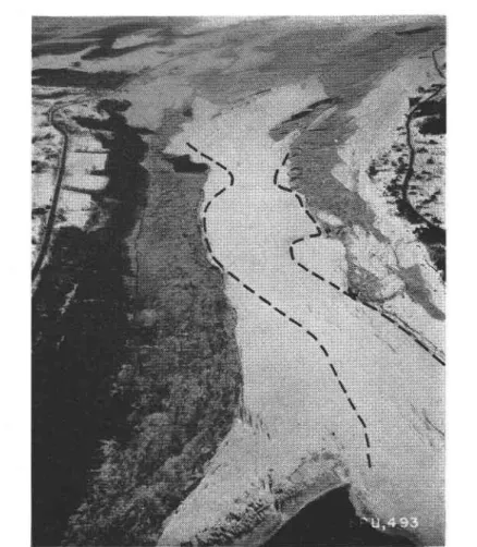
The disturbed area of the ice cover was about r,2oo m. in length arld. at a site where the river narrowed from about 55o m. to a little under 3oo m. Within this area were two very large.hum_ps between 45o and 6oo m. long and about r50 m. wide (Fig. r). In the photograph, the river flows from the top to the bottom. Figure r shows to a limited extent the widening of the river above and below the site of the humps.
Each hump rose gradually to a height beiween ro and 12 m. above the water surface. This can be seen in Figure z where part of the down-stream hump is shown in profile. The up-stream hump can be seen in the background.
At the top of the humps were several large longitudinal cracks (Fig. r), up to a metre in width. Although the cracks were usually snow-filled, at some places the upper part of the humps was exposed in profile as shown in Figure 3. It could then be seen that thi surface of the humps consisted of a layer of clear river ice some 25 cm. thick overlain with snow. Beneath the clear ice was a porous ice deposit which had a density of about one-third that of normal ice. The cause of the formation of the humps presented an interesting problem to unravel. Up-stream from the humps, extending for a distance of almost 6 km., iJ a turbulent section of river known as the Long Sault Rapids. In this section the water flow is so rapid that during winter no ice cover develops but rather the ice formed is carried in suspension as an agglomer-ate of needles and plagglomer-ates known in Canada as frazil ice. It would appear that this frizlt ice is carried down-stream and deposited at the under-surface of the ice cover. This would require that the river slow down considerably in the narrow section where the humps a.e located, indicating that the water must be quite deep. That an ice cover some 25 .*. fhick formed at this site is further evidence that the water speed must be low, because it is known that ice covers will not form readily on water flowing at speeds in excess of about o.5 m./sec.
Two trips were made to the site of the humps during the winter of 196r-162. At the time of the first visit, there was an almost vertical rock face about 9 m. high ot th. north side of the river at theshore edge. The upper part of the face can be seen in Figure 3. The top of the humps was about level with the top of the rock face. At the time of the second visit the water levil had risen about g m. due partly to spring run-off and partly to the closing of a new dam
s69
574 T O U R N A L O F G L A C I O L O G Y
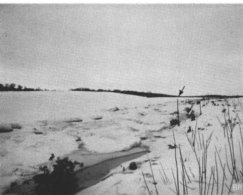
down-stream. Only about o.5 m. of the top of the rock face was above water. The ice humps had risen as well showing that they were floating. The shape of the humps could now be seen clearly against the background of trees on the opposite side of the river. The space between the shore and the hump edge was filled r,t'ith ice pans and water was visible at some locations. This, as well as the edge of the rock face, can be seen in Figure z.
Since the ice humps float, the amount of ice beneath the surface must be about nine times that above. This indicates that the maximum depth of the water must be at least 90 m. Hydrographic maps of the river showed only that the depth was greater than rB m. This was the maximum depih recorded bv parties surveying the river for hydrological and navigational purposes.
Fig. t. Aerial uiew of ice humps at Greece's Point takenJrom an altitude of about 6oo m. Greece's Point and the highua-y are seen on lhe right. The dathed lines otrlline the humped region
After the ice had melted in the spring, arrangements were made to measure the water depth. IJnfortunately, the echo-sounding equipment available had a range of only r5o ft.
(+S *.). The observations with the echo sounder were supplemented therefore by measure-ments made with a sounding line.
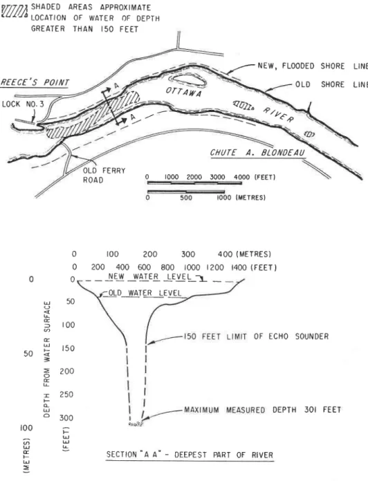
Three cross-sections were obtained with the echo sounder, one near each end of the site and one at the centre. A run was made as well in the longitudinal direction. Figure 4 shows
I'-ig' z. The ice humps photographedfrom the north shore oif the Ottawa Riaer. Ice pans and uater can be seen between the rock .face al the shore and the edge of the ice humps, The arrow locates the up-stream hump
Fig. 3. An exposure of the upper part of one of the humps b1 a longitudinal crack. Note the z5 cm. of clear riuer ice underlain blt porous xce
5 7 2 J O U R N A L O F G L A C T O L O G Y
the approximate location o1'the 45 m. contour line and the cross-section at location ae. 'Iwcr soundings with the line near location AA gave depths of 79. 5 and 9 r . 5 m. These observations showed that there is a trench about I,2oo m. long, go m. wide with walls about 75 m. high at
'-: '- NEW'
aaJz
FLOODED 0 1 0 S H O R E S H O R E L I N E LIN E,,,,e
t >
orrA il/i
!'"o)
0 0 0 u 5 0 I E f I U U E U5 0 5
r r u
=
= 2 n o o E T 250 F c U o ? n n 100 .-U @ u U L t F t!7 7 1 7 2 t r s n a D E D
A R E A s
a p p R o x t M A T E
tutua 1g6g11oN oF WATER oF DEPTH G R E A T E R T H A N I 5 0 F E E T 6REECE,S POIilT L o c K N 0 . 3
J
\--CHUTE A. OLOIlOEAU O L D F E R R Y R O A D 0 1000 2000 3000 4000 (FEET) I O O O (M E I R E S } r 0 0 2 0 0 3 0 0 4 0 0 ( M E r R E s ) 200 400 600 800 t000 t200 t400 (FEETI O F E C H O S O U N D E R D E P T H 3 0 I F E E l S E C I I O N ' ' A A ' ' - D E E P E S T P A R T O F R I V E RFig. 4. Map and crpss-section of ice hump location
the site where the ice humps formed. They show also that the rock face observed on the north shore of the river on the first visit was the edge of the trench.
_ _ NEJ _ rvArER !EJ!L-L _ _
A trench of this size was indeed an interesting discovery and of considerable geological significance. Consultation of geological maps showed that it is located in a limestone and dolomite formation of early Ordovician age. Back from the river a short distance, the lime-stone is overlaid with a shale formation. There is a fault running in a north-easterly direction on the south side of the river that intersects the river at the up-stream end of the trench. Pot-holes are present in the rocks some 6 m, above the present water level, indicating a much higher water level and very rapid flow at some earlier date. The bottom of the trench is about 45 m. below the present sea-level. Although the speed of the river is reduced considerably at this site, the trench has not filled by sedimentatron.
The observations showed that the humps are formed by the deposition of frazll ice in the more slowly moving water in the trench. The frazil ice is manufactured up-stream in the rapids. The size of the humps and the trench is a dramatic illustration of the great quantities of ice that can be produced in fast flowing water in even the more temperate regions of Canada, and an indication of the difficulties that can plague hydro-electric installations exposed to such conditions.
The humps are a familiar and recurring feature of this section of the river. An early explorer, Chevalier de Troyes, noted their presence in his 'Journal of an expedition to Hudson Bay" in 1686 (Troyes, r9r8). IJnfortunately, the humps will probably never form again, at least within the period of industrializedrnan, because in the I'all of r96r the Carillon Dam was completed. This dam, located about g km. down-stream from the site, was closed in the spring of r96z. The increase in the water depth observed on the second visit to the site was a consequence of this. When the water depths were measured, the water level was about I,o'5 m. above the previous normal. The depths at the two sites sounded were therefore about 69.5 and 8r.5 m. when the humps formed.
In the future, the control level of the river at the site of the humps will be about rz m. above the previous normal. The water level at the Long Sault Rapids will probably be raised to the extent that the velocity of the water will be reduced sufficiently to allow an ice cover to form. This will remove the source of frazil ice.
It is unfortunate that just at the time when attention was drawn to this unique natural phenomenon, it should fall victim to progress before an adequate record of its features could be obtained.
AcxNowr,nocEMENTS
The authors are greatly indebted to Miss H. Lambart, Greece's Point, for informing them of the ice hump and for being their guide during visits to the site. They also wish to express their appreciation to the Photographic Section of the Division of Mechanical Engineering, National Research Council, for the air photographs, and to the Hydraulics Section of the same Division for its assistance in measuring the water depth.
This paper is a contribution of the Division of Building Research, National Research Council, and is published with the approval of the Director of the Division.
MS, receiaed tz October rq6z
R E F E R E N C E 'I'royes,,Cheualier
P. d9. rgt9. Journal fu I'expidition duCheaalier de Tro-yes d la Baie d'Hudson, en t686, iditd et annoti par l'Abbd laanhoe Caron. Beauceville, La Compagnie de I'Eclaireur.