UNIVERSITE DU QUEBEC
A
MONTREALPROGRAMME DE MAiTRISE EN BIOLOGIE EXTENTIONNE
A
L'UNIVERSITE DU QUEBEC EN ABITIBI-TEMISCAMINGUEHISTORIQUE DES FEUX AU NORD DU TEMISCAMINGUE, QUEBEC
MEMO IRE PRESENTE
COIVIME EXIGENCE PARTIELLE DE LA MAiTRISE EN BIOLOGIE
PAR
DANIEL JAMES GRENIER
Mise en garde
La bibliothèque du Cégep de l’Témiscamingue et de l’Université du Québec en Abitibi-Témiscamingue a obtenu l’autorisation de l’auteur de ce document afin de diffuser, dans un but non lucratif, une copie de son œuvre dans Depositum, site d’archives numériques, gratuit et accessible à tous.
L’auteur conserve néanmoins ses droits de propriété intellectuelle, dont son droit d’auteur, sur cette œuvre. Il est donc interdit de reproduire ou de publier en totalité ou en partie ce document sans l’autorisation de l’auteur.
REMERCIEMENTS
Je voudrais en premier lieu remercier mes directeurs, Yves Bergeron et Dan Kneeshaw, de m'avoir fourni cette experience unique d'apprentissage. J'aimerais egalement les remercier pour leur patience, leur perspective continuellement positive et aussi d'avoir su insuffle ou partage avec moi leur passion pour l'ecologie forestiere. De plus, j'aimerais exprimer rna gratitude au Dr Sylvie Gauthier pour avoir genereusement partage son temps et ses idees, ainsi qu'endure mes questions et mes courriels tout au long de ce pro jet.
Je remercie I'Universite du Quebec en Abitibi-Temiscamingue pour son soutien financier au cour·s de mes etudes, ainsi que Monique Fay pour le temps et !'assistance qu'elle m'a apporte sur des questions academiques et personnelles.
J'exprime toute rna gratitude au Dr Drew Barton pour avoir elargi rna perspective, de m'avoir fourni !'inspiration et d'avoir toujours cru en mes capacites. Sans son soutien continu, tout ceci n'aurait pas ete possible pour moi. J'aimerais egalement montrer rna gratitude
a
Ia communaute scientifique de I'Universite du Mainea
Farmington (UMF) pour son support continue! au cours de me!s activites academiques poste-UMF. Je remercie le Dr Sylvie Charron pour son optimisme et son encouragement, ainsi que pour avoir ouvert le monde francophonea
mes oreilles,a
mes yeux eta
mon coour.La realisation de ce travail n'aurait pas ete possible sans l'aide technique de nombreuse!s personnes. Je remercie, en particulier mes aides de terrain Judy Dore Ht Jamie Owens, ainsi qu'Herve Bescond, Martin
iii
Simard, Annie Belleau, Daniel Lesieur et Dominic Cyr pour leur support technique. J'aimerais exprimer toute ma reconnaissance
a
mes amis (es) et collegues qui ont ecoute mes idees, ont contribuea
leur formulation, ont participea
Ia correction de mon f ran<;ais ou qui ont seulement p artage un sourire, en particulier Martin "Undercover Brother" Simard, Fateh "nik mouk" Sadi, Mark Purdon, Annie Belleau, Krassimir "Jack Daniels" Naydenov, Herve "Big Bucks" Bescond, Marie-Claude "super lasagne" Bujold, Claude Bouchard, Miscou et MariH-Helene Longpre.Finalement, je tien:s
a
remercier mes parents, Don et Dee, pour leur amour et leur soutien inconditionnel; ce memoire n'aurait pu etre realise sans cela.A
mes autres etres chers, Jacque, Pat et Noah, mon frere Mark, mon "life-line" Renee, Paul, Steph, Cam, et Anissa, je les remercie de m'avoir ecoute, de leur attention et de ne jamais avoir doute de moi.TABLE DES MATII~RES
LISTE DES FIGURES... ... ... ... vi
LISTE DES TABLEAUX... ... ... . vii
RESUME... ... ... ... viii
INTRODUCTION GENERALE.. .. . . .. . .. . .. . .. . . .. . .. . . .. . . .. . ... . ... 1
0.1. Problematique generale et objectif.. .. . .. . .. . . .. . .. . .. . .. . . 1
0.2. Les controles ;3 l'echelle spatiotemporelle et les objectifs secondaires.. .. . .. . . .. . . .. . .. . .. . .. . .. . .. . . .. . .. . .. . .. . .. . .. . .. . .... 1
CHAPTER I FIRE FREQUENCY AT THE NORTHERN LIMIT OF THE TEMPERATE FOREST OF SOUTHWESTERN QUEBEC, CANADA 1 . Abstract.. . . 7
2. Resume.. ... ... 8
3. Introduction... ... ... 9
4. Study Area... 11
5. Methods... ... ... 13
5.1 Fire history reconstruction... ... 13
5.2 Sample collection and analysis... 14
5.3 Fire frequency estimation... 15
6. Results ... .. ... ... ... ... 18
6.1 Forest age distribution... ... 18
v
7. Discussion... .... ... 19
7.1 Factors controlling fire frequency... ... 19
7.2 Natural fire cycle for the northern temperate forest... 22
7.3 Implications for sustainable forest management.... ... 22
8. Acknowledgememts... .. . .. . ... .. . .. . .. . .... .. .. . .. . .. . .. . .. .... ... .... 23
9. References... ... 24
CONCLUSION GENERALE.. .. . .. . .. . .. . .. . .. . .. . .. . . .. . .. . . .. . .. . ... . . .. 38
STRATEGIES D'AMENAGEMENT FORESTIER... .. . .. . .. . .. . .. ... .. . . .. 41
Figure 1. Figure 2. Figure 3. Figure 4. Figure 5. Figure 6. Figure 7.
LISTE DES FIGURES
Modelisation d'une approche ecosystemique de gestion du territoire. Le but de cette etude est de
Page
s'assurer les connaissances de Niveau 1... 5 Location of the study site found in the Temiscamingue region of southwestern Quebec, Canada... 31 Diameter-age relationship (y
=
0.2733 x + 9.265, ~=
0.671, n=
409) for yellow birch used in age estimation of field measured individuals... 32 Forest age distribution identified for the study area ... . 33 Forest age distribution found for the study site considering land use patterns . . . 34 Cumulative time since fire distributions usinglogarithmic scale comparing: (1) global distribution, (2) relief, (3 ) superficial deposits, (4) mean distance to firebreak, (Ei) land use patterns (north vs. south), and
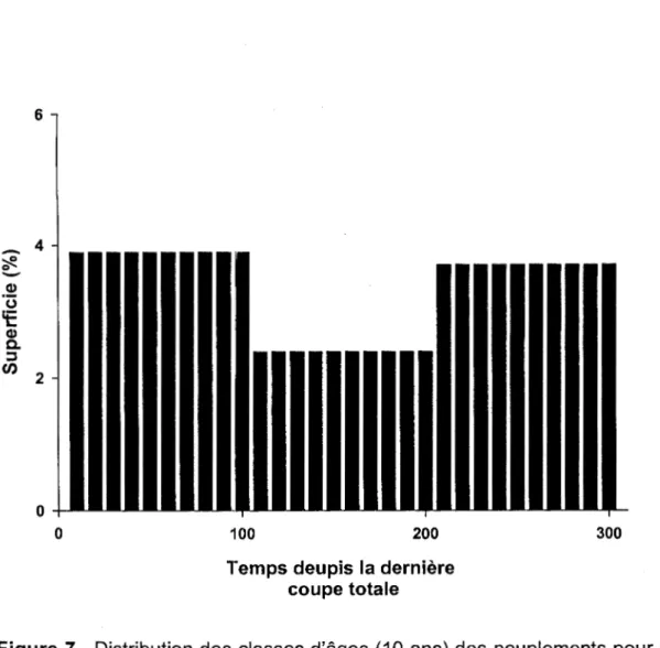
(6) land use patterns (west vs. east)... 35 Distribution des classes d' ages ( 1 0 ans) des peuplements pour un cycle de perturbation de 200 ans et un agH maximal d'exploitation de 100 ans. L'importance relative placee sur Ia troisieme cohorte resulte de Ia composition basee sur toutes les fon§ts plus que 2:00 annees vieilles et ces plus que 300
Table 1.
Table 2.
LISTE DES TABLEAUX
Survival analyses and Lagrange probability results validating spatial and temporal influences while testing
Page
if the hazard of burning was constant with time... 36 Fire cycle estimates for different localizations and different time periods for Temiscamingue, Quebec... 37
RESUME
L'historique des feux a ete reconstruit pour une superficie de 2500 km2
a
!'interface de Ia foret boreale et de Ia foret feuillue septentrionale du sud-ouest du Quebec. L'objectif primaire de ce projet etait de recolter les donnees debase necessairesa
I a description d u regime de feux n aturels, dans un contexte de remplacement des peuplements apres incendies severes pour Ia region du Temiscamingue. Cette description du regime des feux constitue egalement l'etape initiale pour le developpement d'un scenario d'amenagement forestier base sur le regime des perturbations naturelles pour cette meme region. Les buts secondaires etaient d'evaluer les effets de differentes echelles spatio-temporelles sur Ia frequence des feux, en determinant le role des fa cteurs explicatifs aux echelles locale, paysagere et regionale. Un dispositif d'echantillonnage aleatoire, utilisant Ia dendrochronologie conjointement avec les archives gouvernementales et les photos aeriennes, a ete utilise pour decrire le cycle de feu dans le contexte du modele exponentiel negatif. Les elements physiographiques ne presentent pas localement d'influence sur Ia frequence des feux. Cependant, les patrons d'utilisation des terres associesa
Ia colonisation affectent significativement Ia frequence des feuxa
l'echelle du paysage. Un changement tempore! dans Ia frequence des feux a ete aussi detecte et co"incide avec Ia periode de colonisation Euro-canadienne, ainsi qu'avec des annees de secheresse extreme pour le site d'etude. De plus, une periode sans feu a ete recemment identifiee et associeea
Ia suppression du feu et aux changements climatiques. Les cycles estimes (-190a
300 ans) pour Ia section sud-est du site d'eltude seraient representatifs des cycles naturels duea
une moins grande influence humaine. Les longs cycles de feu observes sont responsables d'unH proportion elevee de forets anciennes dont Ia dynamique est surtout contr61ee par des perturbations secondaires (trouees, epidemies d'insectes). Par consequent, un regime d'amenagement forestier equiennea
rotation courte qui serait inspire du regime des feux esta
remettre en question pour ce secteur. Des pratiques sylvicoles plus diversifiees s'inspiranta
Ia fois d'une frequence faible des feux et surtout de Ia presence des perturbations secondaires serait plus en accord avec une approche d'amenagement s'inspirant des perturbations naturelles.INTRODUCTION GENERALE
0.1. ProbiE~matique generale et objectif
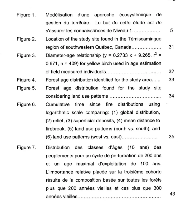
Mon travail de maitrise s'integre dans un plus grand projet, en collaboration avec Tembec, groupes des produits forestiers, dont l'objectif final est de developper et de mettre en place au Temiscamingue une strategie de gestion du territoire basee sur les patrons historiques des perturbations naturelles . Ce processus tient compte du maintien de Ia composition, de Ia structure, et des fonctions des peuplements. Cette approche de gestion ecosystemique a ete suggeree afin de faciliter Ia conservation de Ia biodiversite et des processus ecologiques essentiels pour lesquels les especes endemiques se sont adaptees au cours du temps (Hunter 1999; Bergeron et al 2001 ).
La premiere etape de ce processus qui constitue le but de cette etude, est de decrire le regime naturel des feux de foret
a
Ia marge nordique de Ia foret feuillue septentrionale (Figure 1 ). Bien que plusieurs etudes aient ete realisees sur les feux dans Ia zone boreale adjacente, les donnees de ce type sont inexistantes pour ceUe zone de transition entre Ia foret feuillue et Ia foret boreale (mais voir Heinselman 1973; Lorimer 1977; Wein & Moore 1979). Par consequent, ce projElt aideraa
Ia comprehension du role des incendies de foret dans cette ecotone entre deux grandes zones de vegetation.0.2. Les controles
;a
l'echelle spatio-temporelle, et les objectifssecondaires
Selon les influences locales et regionales, les patrons observes dans les regimes de feux se produisent
a
des echelles spatio-temporelles differentes. (Brown et al 2001; Barton et al 2001; Heyerdahl et al 2001; Turner & Rom me 1994 ). II a ete demontre que les caracteristiques2
physiographiques et le type de vegetation peuvent avoir un effet important et une interaction sur les feux
a
de petites echelles spatiales et sur de courtes echelles temporelles. Ces elements affectent Ia distribution, !'occurrence, Ia propagation et Ia severite des feux. Les zones escarpees, !'elevation et I' orientation de Ia p ente (i.e. I' exposition) produisent des variations dans le microclimat, ce qui determinent des gradients ecologiques. Les types de vegetation e t I es associations v arient I e I ong de gradients d 'humidite e t de substances nutritives, ainsi que d'autres facteurs. Ainsi, !'ensemble de taus ces facteurs determine le type, Ia distribution et Ia quantite de combustible, ce qui finalement determine les patrons locaux de feu. Les variations climatiques annuelles sont egalement ressenties le long des pentes en raison de !'elevation, ce qui affecte l'humidite du combustible et !'ignition du feua
une echelle saisonniere.Ces contr61es locaux peuvent etre neanmoins dissimules
a
l'echelle du paysage eta
l'echelle regionale par les changements climatiques et par !'influence humaine qu i ant pour resultat de synchroniser le feu sur une grande echelle ou le su pprimer sur de grandes etendues et sur de longues periodes de temps (Flannigan et al 2000; Kitzberger et al 1997; Johnson &Wowchuck 1993; Swetnam & Betancourt 1998; Clark 1990; Bessie &
Johnson 1995). Dans les etudes realisees en foret boreale, les chercheurs ont trouve une reduction dans Ia frequence de feux qui correspond au rechauffement suivant Ia fin du "Petit Age Glaciaire" (- 1850 AD) (Engelmark et al 1994; Bergeron & Archambault 1993; Bergeron 1991; Weir et al 1999;
Lesieur et al 2002). Ce1te diminution dans l'activite du feu a ete attribuee
a
une frequence reduite de periode de secheresse suivant le "Petit Age Glaciaire". Dans !'ouest des Etats-Unis, Ia suppression des patrons de feux historiques a ete observee avec les changements dans !'usage du territoire, ce qui corresponda
Ia colonisation Euro-americaine (Swetnam 1993;3
Swetnam & Baisan 1996; Brown et al 2001 ). De plus, !'introduction du betail co"incide avec Ia cessation des feux de surface.
Comme second objectif de !'etude nous voulions determiner !'importance des facteurs spatio-temporels sur Ia frequence de feux et de determiner leur influence
a
des echelles locales, paysageres et regionales. Pour Ia region d'etude situee dans Ia region du Temiscamingue, nous avons examine les influences dHs patrons d'usage du territoire, le relief, Ia distance moyenne aux coupe-feux et les depots de surface, afin de determiner si Ia frequence de feux etait spatialement constantea
l'echelle locale. Considerant Ia topographie variee et plus complexe pour Ia region du Temiscamingue comparativementa
celle observee dans Ia zone boreale adjacente, nous avons pose comme hypothese que ces elements physiographiques a uraient des relations s ignificatives a vee I a frequence de feux. Puisque Ia concentration humaine est plus elevee dans Ia section nord-ouest du site d'etude, nous avons teste !'impact anthropogenique sur le cycle de feux et son effeta
Ia mesoechelle, et aussi pose !'hypothese que cette influence serait plus grande pres des concentrations humaines.La comparaison d1e Ia distribution des peuplements forestiers avant et apres 1890 de meme qu'avant et apres 1850 ont aussi ete exploree et les changements temporels possibles dans Ia frequence des feux et leurs impacts
a
l'echelle du paysage et regionale ont ete identifies. L'annee 1890 a ete choisie puisqu'elle corresponda
Ia colonisation du nord-ouest du site d'etude. Nous avons pose !'hypothese que des cycles de feux plus courts seraient observes apres 1890, puisque que !'impact humain aurait pu avoir une plus grande influencea
l'echelle du paysage. La fin de Ia periode du "Petit Age Glaciaire", qu i dans Ia foret boreale correspond aux annees 1850,4
a ete etudiee car le c:hangement de climat observe
a
cette epoque corresponda
Ia modification de Ia frequence de feuxa
grande echelle.---
---
_____ _______... ~
/
'
/ Outils d'amemagement \
Niveau 3: Objectift---\ ecosystemique (coffre d'outils )
Ultime ,, sylvicoles) pour Ia foret mixte / '
···---···--
'·,...____ ____ ____
f ___ ____ ....
---/
F---·
··· ·j··---·---···\-~~
___ ____ ___ ______________ L_____________________ \ \. Modelisation des scenarios '
/
, pYivicoles altematifs afin de \
~ibler les methodes les plus '\,
Niveau 2:
I
lapproprieesa
tester sur lelndicateurs de
1 · terrain
planification et _
i
-·-;rr-~~;::----de suivi pour --- · / / ! ---~
l'amenagement 1 / 1 ' ,
ecosystemiq/ue
~Re::~b~i;~~-,- lr~di~~~~~~.;;:f~O~d~
forestieres et les differentes echelles 1
erturbations naturelles _ _ _ j
I
\
I
\
II
'\
///
'\.
///,--~~n~miq:.
de la-;,o,;;;:l \ 1/f-D~;:,~~
nalucelle de• .] \\\\, / forestierer
peuplements / L. ... - . --- ---···----· ·-- Jf ., ... _________ \ I I ' , " / ____ ... ---···---r--- -- ~---··· ···--- - - - -- --- --·----·---/ ''""
,---/L---~,.._---/1 '-.. I / I '-..,'-..._ I 'I
/
1 '-.., Connaissance deConnaissance des _ _ ,Interactions entre ,.. __________
j
l'effet des ,regimes de feu
i
les perturbations : epidemies, de Ia !l
'
TBE et des trouees:--- -- - --- - - -- ... J ---.--- --~ --- ---~
~---~-~~~~-~-~-~onnai~~-~~-~-~--~-~-~~-~~----····-1
Figure 1. Modelisation d'une approche ecosystemique de gestion du territoire. Le but de cette etude est de s'assurer les connaissances de Niveau 1 sur le regime des feux.
CHAPITRE 1
FIRE FREQUENCY AT THE NORTHERN LIMIT OF THE TEMPERATE FOREST OF SOUTHWESTERN QUEBEC, CANADA
GRENIER, Daniel J., BERGERON, Yves, KNEESHAW, Daniel D. & GAUTHIER, Sylvie
L 'article a ete soumis
a
dE~S fins de revision le 1 novembre 2002a
Ia Revue1. ABSTRACT
Fire history was reconstructed for a 2500 km2 area at the interface between the boreal coniferous and northern hardwood forests of southwestern Quebec. The fire cycle was described using a random sampling strategy which included dendrochronological techniques in conjunction with provincial and national government archival data. R esults showed that topography and superficial deposits did not have a spatial effect on fire frequency at the local scale. Human land use patterns associated with colonization in the northwestern section of the study area, however, were detected to spatially influemce fire frequency by altering regionally controlled fire regimes at the landscape scale. Temporal variations in fire frequency were also observed with results suggesting fire patterns in the remote past followed a regional climatic signal that was interrupted by human settlement around 1890, in concurrence with an extreme dry period in the early 1900's. A fire-free period observed in recent times (2000-1949) is potentially related to fire suppression and cl.imate change. In this context, the exact fire cycle was difficult to set, but should be similar to the cycles identified for the most distant epochs in the southwestern part of the territory. In the context of forest management based on natural disturbance patterns, even-aged management under short rotations should be questioned as fire cycle estimations for this northHrn transitional zone imply the use of more complex harvest systems.
2. RESUME
L'historique des feux a ete reconstruit pour une superficie de 2500 km2
a
!'interface entre Ia foret boreale et Ia foret feuillue septentrionale du sud-ouest du Quebec. Le cycle des feux a ete decrit avec un dispositif d'echantillonnage aleatoire utilisant Ia dendrochronologie conjointement avec les archives des gouvernements provincial et federal. Les resultats ont montre que Ia topographie et les depots superficiels n'ont pas eu d'effet sur Ia frequence des feuxa
l'echelle locale. Cependant, les patrons d'utilisation des terres associesa
Ia colonisation dans Ia section nord-ouest du territoire d'etude influencent Ia frequence des feux en alteranta
l'echelle du paysage le regime des feux controle regionalement. Des variations temporelles dans Ia frequence des feux ont aussi ete observees, suggerant que dans un passe lointain le feu suivait un signal climatique regional qui a ete interrompu par Ia colonisation v ers 1 890 en concordance a vee des periodes de s echeresses extremes au debut des annees 1900. Une periode sans feu a ete observee dans les dernieres annees (1949-2000), potentiellement reliee aux changements climatique8 eta
Ia suppression active des feux. Dans ce contexte, un cycle des feux exact a ete difficilea
determiner. Nous estimons que le cycle naturel dHvrait s'approcher des cycles identifies pour les epoques les plus lointaines dans Ia partie sud-ouest du territoire. Dans un contexte d'amenagement forestier base sur le regime des perturbations naturelles, l'amenagement equienne sur de courtes rotations est remis en question. Des systemes de recolte plus complexes integrant le regime des perturbations secondaire8 sont suggeres.3. INTRODUCTION
Fire is a key process shaping forested ecosystems throughout Canada (Weber & Stocks 1998; Payette 1992; Heinselman 1981 ). These systems and their components (i.e. communities, individual species, and processes)
are affected and have adapted to interaction with fire over time (Weber &
Stocks 1998). However, fire exhibits variability in severity, size, and time between events at all spatial scales (Bergeron et al 2001; Whelan 1995; Payette 1 992; Flannigan & Van Wagner 1991 ). Fire can vary from a light surface burn affecting only understory vegetation to an intense stand replacing crown event. The area burned may be over an entire region, or on a more local scale distu rbing only single stands. Some areas may burn frequently while others do not experience any fire for thousands of years. It is the interaction and variation of the above elements that influence and characterize the fire regime on the regional, landscape, and local scales.
Regional scale climate patterns synchronize fire occurrence across large areas (Flannigan et al 2000; Kitzberger et al 1997; Swetnam & Baisan 1996; Johnson & Wowchuck 1993; Swetnam & Betncourt 1990). A classic example is found in the southwestern United States where interannual variation in moisture ava ilability has been observed to control and time region wide fire patterns (Swetnam & Betancourt 1990). Work in the con iferous forests of the southern Canadian Rockies has shown average fire frequency in terms of inter-fire interval spacing to be extraordinarily uniform (Johnson &
Wowchuck 1993) with synoptic-scale weather mechanisms functioning as controls. A difference in annual a rea burned between large and small fire years was related to differences in fuel moisture caused by mid-tropospheric anomalies in the Northern Hemisphere. However, shifts in regional climate may alter natural fire patterns, which may become the means for major
10
ecosystem alteration (Stocks 1993). A reduction in fire frequency attributed to large-scale climate chan9e following the end of the "Little Ice Age" has been identified in many different parts of the boreal forest (- 1850 AD; Johnson et al 1990; Johnson & Larsen 1991; Bergeron 1991; Bergeron & Archambault 1993; Engelmark et al 1994; Weir et al 1999; Lesieur et a/ 2002). Furthermore, a decrease in fire frequency in much of eastern Canada has been predicted by Flann i~J an et al (1998) under a 2 X C02 scenario.
Small-scale deviations from regional fire regimes have been attributed to variations in microclimate and fuel load controlled by local site factors (Barton et al 2001; Brown et al 2001; Heyerdahl et al 2001; Turner & Romme 1994 ). Steep grades in elevation, changes in aspect, and other physiographic features have been shown to promote spatial changes in fire regimes by influencing fu el moisture, humid ity, and interaction with the wind, thereby affecting the probability of fire (Whelan 1995; Rowe & Scotter 1973). At the landscape scale, f1eatu res such as lakes, streams, wetlands, and moist slopes have a I so been found to function as natural firebreaks affecting fire behavior and distribution (Larsen 1997; Bergeron 1991; Romme & Knight 1981; Heinselman 1973).
Humans have strongly influenced fire regimes at all scales. Colonization has created improved access to once remote areas providing an increased potential for fi re ignitions (Weber & Stocks 1998). In fact, national statistics have shown that human induced fires make up the majority of the ignition sources in Canada (Anonymous 2002). Conversely, improved access to these remote locations provides a greater chance for earlier fire detection and active suppression (Weber & Stocks 1998). Suppression activities have
11
generally been shown to affect fire regimes by lengthening the fire cycle (Everett et al 2000; Barrett et al 1991; Tande 1979). These measures introduced to southern Cluebec in the 1920's were, however, considered ineffective until the early 1970's (Bergeron 1991; Lefort et al 2002).
Fire history and behavior in boreal forests have received much attention in the past two decades, which has culminated in the most recent years into natural disturbance dynamic based forest management strategies (Bergeron & Harvey 199l ; Bergeron et al 1999; Bergeron et al 2002). This approach allows for the maintenance of stand composition, structure, and functions similar to those~ occurring naturally, which has been suggested to aid in the maintenance of biodiversity and vital ecological processes to which endemic species have adapted through time (Hunter 1999; Bergeron et al 2002). In contrast, little is known concerning the role of fire at the interface of the boreal and northern temperate forests. In order to improve our knowledge and comprehension on the function fire has in this relatively unstudied area, we worked within this transition zone. Our objectives were to reconstruct and to describe the fire history in the context of stand replacing events at the northern margin of the northern temperate forest of southwestern Quebec. Spatial and temporal influences were assessed to identify their impact on the fire cycle at the local, landscape, and regional scale.
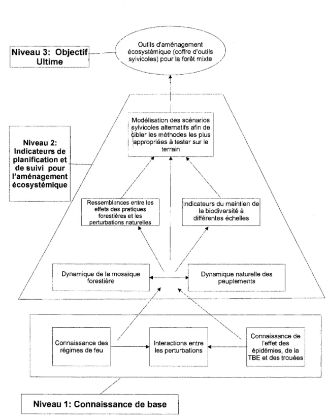
4. STUDY AREA
The study site is located within the Temiscamingue region of southwestern Quebec, Canada bordering eastern Ontario along the Ottawa River (-4JD30'N - 79°00'\N; Figure 2). The region is found within the Northern Temperate Zone located just below and adjacent to the boreal forests of
12
southwestern Quebec (Saucier et al 1 998). The surface area oft he study area measures approximately 2500 km2• Average altitude is about 350
meters, with moderate relief composed of hills and depressions with intermediate slopes throughout. Rock escarpments exist in the western portion of the region. Surface deposits are composed mainly of glacial till and lacustrine deposits; 20% of the surface area is made up of water bodies (Robitaille & Saucier 1998). Average annual temperature is 2.5°C to 5.0°C, and average precipitation measures 800 to 900 mm per year, 25% falling as snow.
The study area !lies within the western Balsam Fir-Yellow Birch Bioclimatic Domain (Saucier et al 1998), which is of a mixed forest type dominated by balsam fir (Abies balamea) and yellow birch (Betula
alleghaniensis), accompanied by white spruce (Picea g/auca), sugar maple
(Acer saccharum), red maple (A. rubrum), and white birch (B. papyrifera).
Fire-associated species such as red (Pinus resinosa), white (P. strobus), and jack pine (P. banksiana) are present on xeric sites (Grondin 1996).
Long-term human influence on the landscape through widespread forestry activities and extensive agricultural land use is known for the northern and western portions of the study area (Vincent 1995). The towns of Bearn, Ville Marie, Belleterre, Angiliers, Laverlochere, and Latulipe are found along the western edges of the territory (Figure 2). Road networks are laid out primarily along the northern and western margins.
13
5. METHODS
5.1 Fire history reconstruction
To obtain preliminary information on the past fire history of the study area, we used aerial photographs from the Canadian National Air Photo Library dating from 1930, 1940, and 1950 along with detailed archival information dating from '1945 to 1998 from the Ministere des Ressources Naturelles du Quebec (MRNQ) on stand history, composition, fire years, areas burned, and site conditions. These data were entered into a Geographic Information System (ArcNiew, version 3.1) to create an initial time-since-fire map (Figure 2). This map shows the fire dates for the last 111 years, and stand distribution since time of last fire not accounting for other disturbance types such as insect outbreaks and windthrow.
A grid system composed of 114 polygons ( -22 km2 per polygon) was overlaid on the study area (Figure 2) to facilitate a stratified random sampling design. Fire dates were used from the archival data set for those polygons that fell within the boundaries of the burns on the initial time-since-fire map (42% of the study site). Polygons positioned outside of the mapped burn areas were visited for de~ndrochronological sampling in order to date stands (Heinselman 1973; Dansereau & Bergeron 1993; Bergeron et al 2001 ). For areas outside the archival data set, sample sites were chosen using an existing permanent and temporary plot system established for commercial forest inventory purposes by the MRNQ (Anonymous 2000a; Anonymous 2000b ). A sampling transect made up of two neighboring permanent or temporary plots (-500m transect) was randomly selected within each polygon out of the more than 500 plots (-1 00 permanent and -500 temporary) in the MRNQ system on the study area. For the 21 polygons without archival data
14
and that did not contain a permanent or temporary plot, a location was randomly selected considering accessibility. A 500 meter transect was then established for sampling purposes with sampling points positioned at 150 and
450 meters.
5.2 Sample collection and analysis
At each visited site, increment cores or cross-sections were taken from five to ten trees (Kipfumueller & Baker 1998). A species hierarchy was considered when selecting individuals for sampling corresponding to sensitivity to post-fire recruitment. Selection rank (from first choice to I ast) was as follows: 1, P. banksiana Uack pine); 2, B. papyrifera (white birch)/8.
alleghaniensis (yellow birch); 3, Populus tremuloides (trembling aspen); 4, P.
mariana (black spruce); Ei, P. glauca (white spruce). Increment core samples
were extracted from the base of the trunk (as low as possible) with attempts made to core through the pith (Phipps 1986). Since heartrot was prevalent in yellow birch trees, diameter at breast height (DBH
=
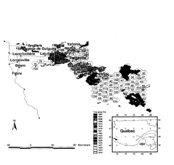
1.4 m) was recorded for future attempts in age estimation. Cross-sections from fire-scarred dead snags were also taken where available (Arno & Sneck 1977). Core samples were mounted, sanded, and aged by the direct counting of the annual rings on the cores using a dissecting microscope (Phipps 1986). For cores that missed the pith, pith locators were used to estimate the number of missing years from ring curvature and growth rate (Applequist 1958). Cross-sections were prepared similarly with rings counted on two axes (Arno & Sneck 1977).A diameter-age regression curve was created for yellow birch using information gathered from the MNRQ permanent plot database (Figure 3). The derived diameter-age relationship was then used to estimate the ages of field-measured yellow birch individuals (Lorimer 1980).
15
Finally, master ring chronologies were assembled from the live samples for the purpose of dating the cross-sections of the dead snags. Crossdating was performed using identified diagnostic rings (i.e. narrow, light, and frost rings) and by measuring annual-ring widths using a Velmex measuring system to the nearest 0.01 mm for comparison with the computer program COFECHA (Yamaguchi 1991; Holmes 1999).
An estimate of time-since-last-fire (TSLF) for sampled polygons was determined when at least three individuals along a transect had an establishment date within a range of 1 0 years for jack pine and 20 years for all other species (Lesieur et al 2002). When samples did not allow for determination of the TSLF event, the polygon was characterized by the age of the oldest individual sampled along the transect (Johnson & Gutsell 1994; Bergeron & Dubuc 1989, Lesieur et al 2002). Data of this sort was considered a minimum estimate of TSLF with the date regarded as censored in further analyses (Lesieur et al 2002). Land use patterns, superficial deposit by class (glacial & fluvio-!~lacia l ), relief (plain - slope from 0-3%, difference in height from 0-30 m/km; hill- slope from 3-5%, difference in height from 30-60 m/km; Robitaille & Saucier 1998), and mean distance to firebreak were determined for each transect. The latter is the mean of the distances to firebreaks (lake, river, stream, and bog) measured a long each of the eight cardinal directions on 1 :50 000-scale topographic maps (Lesieur et al 2002).
5.3
Fire frequency estimationTSLF estimates were pooled and put into decadal age classes with the cumulative percentage plotted on a logarithmic scale. Initial investigative
16
observations (by eye) were carefully made for changes in slope, which would indicate mixed distributions, suggesting spatial or temporal changes in the fire frequency (Johnson & Guts ell 1994 ). We examined, by class, the influences of land use patterns, relief, mean distance to firebreaks, and surface deposits to determine if the fire cycle was spatially constant. Since concentrations in human settlement and la nd use patterns were observed in the northern and western sections of the study area, we tested if human influence resulting from colonization, leggin~~. agricultural activities, or fire suppression spatially affected the fire frequency (Heyerdahl et al 2001; Lesieur et al 2002; Weir et al 1999; Lefort et al 200:2). To this end, the territory was equally divided in half (North vs. South, and then West vs. East). The influence of relief on the fire cycle was tested given that this factor is also thought to have an important effect on fire regimes at tlhe local and landscape levels (Heyerdahl et al 2001; Turner & Romme 1994; Hemstrom & Franklin 1982). Firebreaks may also affect fire spread (Larsen 1997); accordingly, we tested its potential impact on the cycle by assessing the influence of mean distance to break on the fire cycle. In addition, the influence of superficial deposits was also examined.
Potential temporal changes in the fire cycle were also investigated by examining stand age distributions before versus after 1890. This time point was chosen because it corresponds with the colonization of the northwestern portion of the study ama (-1880-1900: Laverlochere, Lorrainville, Bearn, Fugerville, -1930: Belleterre; Vincent 1995). The times before and after 1850 were a I so explored as a potential d istributional break point since this date in the bordering southern boreal forest of Quebec is the end of the period known as the "Little Ice Age" (Bergeron & Archambault 1993).
One hundred and fourteen TSLF observations and the above mentioned spatial and temporal covariates were individually fit using the
17
exponential model in the PROC LIFEREG procedure of SAS (SAS Institute Inc. 1990), which provides a standard maximum-likelihood estimate (MLE) for each covariate or classes of a covariate (Allison 1995). A chi-square test evaluated whether the survival estimates of the different covariate or classes of a covariate were significantly different. In addition, survival models using the temporal and spatial covariates individually found to statistically have an influence on fire frequency were explored in conjunction to identify their relative importance. For each survival model, a Lagrange multiplier chi-square test was performed to see if each hazard function was constant over time. This is a one degree-of-freedom test for the null hypothesis that the scale term in the negative exponential model equals one. Fire cycles were estimated by locating the mean age of the survival distributions. Sixty-three percent of a II fire initiated units are younger than the sample mean with a negative exponential age distribution (Van Wager 1978). The PROC LIFEREG procedure also allowed for the censoring of data while estimating the fire cycle by using standard right censoring procedures observed in maximum-likelihood methods (see Allison 1995). Thirty-seven percent of the data was categorized as censored in this study.
Post hoc likelihood-ratio tests were also performed to evaluate model
goodness-of-fit. Results showed that the weibull model did not provide a better fit than that obtained with the negative exponential model in all cases except when analyzing temporal influences and temporal and spatial influences combined. It is possible that the natural fire regime was altered on the study site to the point where the negative exponential model may not provide the best fit for the data. However, considering the coarse scale resolution obtained with our sampling strategy, the testing of more complex
18
non-linear models is questioned. Consequently, the negative exponential model was felt to provide adequate fire cycle estimations.
6. RESULTS
6.1 Forest age distributiion
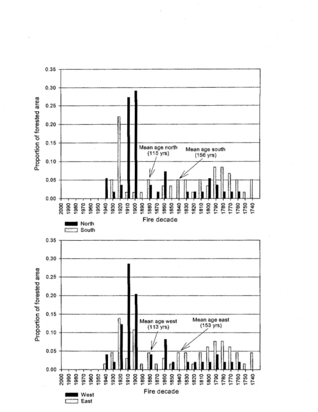
Mean stand age (± SO) was 136 ± 60 years and approximately 52% of the forest was older than 100 years (Figure 4 ). The proportion of recruitment per decade appeared relatively constant and stable (- 3 to 4% per decade) from the mid 1700's until 1900, at which point recruitment tripled for the next three decades (early 1900's). From the 1950's to the present, no large-scale fire events were observed (< 5000 hectares burned for the entire study site from 1950 to 2000). Fon9st stands were generally younger in the north and west, areas more subject to human effects, than in the south and east (Figure 5). Mean ages (± SO) WE3re 115
±
47 years for the north, 156±
65 years for the south, 113±
57 years for the west, and 153±
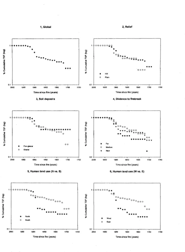
62 years for the east.6.2 Cumulative TSF distribution & survival analyses
Globally, the cumulative time-since-fire distribution was found to fit a negative exponential model with an estimated fire cycle of 136 years (Tables 1 & 2). The period from 2000 to 1949 was left out of the analysis since no large-scale fire events were observed during th is time. The fire frequency was not statistically influenced by relief, soil deposits, or distance to fire breaks (Table 1, Figure Ei). Survival analysis, however, did detect significant differences in fire cycles attributed to human land use patterns (dividing territory into north vs. south, west vs. east; Table 1, Figure 6), with shorter fire
19
cycle estimates observed in the northern and western sections of the study site than in the southern and eastern portions (Table 2).
Significant temporal influences were also detected for before versus after 1890 (Table 1 ). Again, we observed no large fires from 2000 to 1949; however, the fire cycle was much shorter in the period directly after colonization (1948-1890) when compared to the period before this event (Table 2). Statistically di'fferent fire cycles were also seen before and after 1850 (Table 1 ). The fire cycle for the period before the end of the Little Ice Age (- 1850) was found to be longer than the period directly after, while no large fires occurred from 1949 to the present (Table 2).
When including both time period and human land use in the survival analysis model, both factors proved to be statistically significant, although p-values suggested time period to have greater importance (Table 1 ). The estimated cycles, when including both land use pattern and time period in the model did not vary largely from those observed while testing each factor individually {Table 2).
7. DISCUSSION
7.1 Factors controlling fire frequency
Though globally our data fit the negative exponential model, age structure results and survival analyses suggest that spatiotemporal factors, nonetheless, play an important part in the fire regime. Topographically complex landscapes, fire breaks, and other site-specific environments hinder fire spread and promote local and landscape level deviations from regional
20
fire patterns (Barton et al 2001; Brown et al 2001; Heyerdahl et al 2001; Larsen 1997; Brown & Sieg 1996; Bergeron 1991 ). However, no differences in fire cycles at the local scale owing to relief, distance to water bodies, and surface deposits were detected in this study site. Even though topographic elements in T emiscamin!gue are generally considered to be variable and irregular when compared to the more homogeneous landscape found in the adjoining boreal zone (Saucier et al 1998; Robitaille & Saucier 1998), these features do not appear to have functioned as obstacles to fire spread as reported for other studies. Certain superficial soil deposits, such as fluvial-glacio types, may also influence in fire intensity. However, it seems that changes in soil types across the study area were also not sufficiently diverse to create significant spatial differences in fire frequency. We also acknowledge, however, that the lack of observed local effects may be attributed to the samplin~l design. The size of the hexagonal grid sampling system (114 units, - 22 km2 per hexagon) only allowed for the reconstruction of large stand replacing events, excluding small and/or less lethal fires, which may be more connected to abiotic factors.
Humans have exerted profound effects on fire regimes, and our results suggest that the Tem isc:amingue region of Quebec is not an exception. Colonization and its atssociated logging and agriculture activities in conjunction with the known extreme dry period in the early 1900's in Quebec (see Lesieur 2000, Lefort: et al 2002) appear to have contributed to spatially mixed fire frequencies with shorter fire cycles in the more developed areas of the north and west. The observed temporal shift in fire frequency to a shorter cycle directly after 1890, moreover, provides further support as to the impact of Euro-American settlement on the fire regime. Other studies have identified
21
an increase in the area burned during the post-settlement period owing to the many fires ignited by human activities (Hemstrom & Franklin 1982; Cwynar 1977). Webber & Stocks (1998) also suggest that an increase in fire ignitions is provided by greater access to the landscape through the settlement process.
Numerous studies tlave shown regional climatic signals to synchronize the timing of fire occurrence across large areas (Flannigan et al 2000; Swetnam & Betancourt 1998; Johnson & Wowchuck 1993; Wotton &
Flannigan 1993; Swetnam & Betancourt 1990). Throughout the boreal forest, researchers have independently shown a decrease in fire frequency associated with a general trend of warming and increased precipitation since the end of the Little Ice Ane (Bergeron et al 2001; Lesieur et al 2002; Weir et al 1999; Larsen 1997; Engelmark et al 1994; Bergeron 1991 ). We have, however, identified shorter fire cycles after 1850 in Temiscamingue. This known regional signal may have been masked at the meso-scale of this study by increased fire activity associated with the colonization process and the relatively short extreme dry period in the early 1900's in Quebec. The fire-free period identified from 2 000 to 1 950 c auld be partially attributed to the warming trend and reduction in droughts observed after the Little Ice Age in Quebec, though active suppression measures may also have played a role. Water bomber planes were introduced around 1970 in Quebec and are considered to have had significant success in fire suppression in the southern part of the province (Bergeron 1991; Lefort et al 2002). Nonetheless, considering the observed relationship of climate with fire, it is possible that the post Little Ice Age period actually produced an increase rather than a decrease in fire frequency in the Temiscamingue region. Results from a fire and climate study by Clark (1988) in the Great Lakes area of the United
22
States suggest at least a 25% increase in fire frequency for the 201h century
considering the warm, dry, climate observed at the end of the Little Ice Age and the absence of fire suppression. Modeling results from Flannigan & Van Wagner (1991) under a 2 X C02 scenario in Canada have suggested an
increase in fire frequency with a potential increase in Seasonal Severity
Rating greater than 40% nationally. Results from this study also showed a similar increase in area burned throughout Canada.
7.2 Natural fire cycle for the northern temperate forest
Given the above mentioned spatiotemporal influences, the precise estimate of a natural fire cycle is difficult to set; however, the notably longer fire cycles detected in the south and east seem to result from fewer anthropogenic influences, and thus most likely better represent the natural cycles for this transition zone. The complex nature of this transitional area sometimes affected by fire and sometime by other disturbances types consequently becomes apparent given a range in fire cycle estimations roughly between 190 and 315 years. Because of the presence of large tracts of old growth forest, patch (i.e. insect perturbation and windthrow) and gap dynamics (i.e. small scale single tree and small group mortality) are also important. It is possible that the presence of multiple disturbance types at the northern margin of the northern temperate forest might explain the particularly high d iversity oft ree sp13cies observed at different scales in the I andscape when compared with the lower diversity levels observed in the adjacent boreal zone.
23
Fire is an important phenomenon setting the mosaic structure even in this southern transition zone between northern hardwoods and boreal coniferous forests. However, if management objectives are to be based on natural disturbance patterns in this area, our results call into question the use of large scale even-aged management systems on short rotations and suggest more diversified silvicultural practices. By the superimposition of the effects of secondary disturbance (i.e. effects of insect outbreaks and other gap-type dynamics) onto the mosaic created by large fires, natural stand dynamics may be emulated to a greater extent, advancing aims towards the maintenance of biodiversity and natural ecological processes.
8. ACKNOWLEDGEMENTS
We greatly appreciate funding for this project provided by the TEMBEC Corporation, as well as the NSERC research grant awarded to Dr. Yves Bergeron. Scholarship endowment was graciously provided by the Universite du Quebec en Abitibi T emiscamingue and the Chaire industrielle en amenagement forestier durable, UQAT-UQAM. Additionally, we are thankful for the competent field assistance of Judy Dore, Jamie Owens, Mark Purdon, and Fateh Sadhi. We also show appreciation to Herve Bescond, Martin Simard, Annie Belleau, Daniel Lesieur, and Dominic Cyr for their invaluable technical support throughout this work.
9. REFERENCES
Allison P.O. 1995. Survival analysis using the SAS system: a practical guide. SAS Institute Inc. Cary, NC. pp. 292.
Anonymous. 2000a. Norrnes d'inventaire forestier: les placettes-echantillons permanents. Ministere des Ressources naturelles du Quebec, Direction des invEmtaires forestiers, Foret Quebec. pp. 201.
Anonymous. 2000b. Norrn es d'inventaire forestier: les placettes-echantillons temporaires - peuplements de 7m et plus de hauteur. Ministere des Ressources naturelles du Quebec, Direction des inventaires forestiers, Foret Quebec. pp. 201.
Anonymous. 2002. Compendium of Canadian forestry statistics: Section 3, forest fires. Canadian Council of Forest Ministers. © 2002. Available from http://nfdp .c:cfm .org/frames2_e.htm [updated 19 June 2002; cited 20 September 2002].
Applequist, M.B. 1958. A simple pith locator for use with off-center increment cores . Journal of Forestry 56: 141.
Arno, S. F. & Sneck, K. M. 1977. A method for determining fire history in coniferous forest of the mountain west. USDA For. Serv. Gen. Tech . Rep. INT-42.
Barrett, S. W., Arno, S.F & Key, C.H. 1991. Fire regimes of western larch-lodgepole pine forest in Glacier National Park, Montana. Can. J. For. Res. 21: 1711-17'20.
Barton, A.M., Swetnam, T.W. & Baisan, C.H. 2001. Fire and Arizona pine dynamics: local and regional factors in a fire-prone madrean gallery forest. Landscape Ecology 16: 351-369.
Bergeron, Y. 1991. The influence of island and mainland lakeshore landscape on boreal forest fire regimes . Ecology 72 : 198-1992.
25
Bergeron, Y. & Archambault, S. 1993. Decreasing frequency of forest fires in the southern boreal zone of Quebec and its relation to global warming since the end of the 'Little Ice Age'. Holocene 3: 255-259. Bergeron, Y. & Dubuc, M. 1989. Succession in the southern part of the
Canadian boreal forest. Vegetatio 79: 51-63.
Bergeron, Y. & Harvey, 13. 1997. Basing silviculture on natural ecosystem dynamics: an approach applied to the southern boreal mixedwood forest of Quebec. For. Ecol. Manage. 92: 235-242.
Bergeron, Y., A. Leduc, B. Harvey, & S. Gauthier. 2002. Natural fire regime: a guide for sustainable management of the boreal forest. Silva Fennica 36 :81-95.
Bergeron, Y., Gauthier, S., Kafka, V., Lefort, P., & Lesieur, D. 2001. Natural fire frequency for the eastern Canadian boreal forest: Consequences for sustainable forestry. Can. J. For. Res. 31:1-8.
Bergeron, Y., Richard, P.J.H ., Carcailler, C., Gauthier, S., Flannigan, M., &
Prairie, Y. 1999. Variability in fire frequency and forest composition in Canada's Southeastern boreal forest: A challenge for sustainable forest management. Conserv. Ecol. [serial online], 12. Article 6. on line http://www .consecol.org/vol2/iss2/art6.
Brown, P.M., Kaye, M.W ., Huckaby, L.S., & Baisan, C.H. 2001. Fire history along environmental gradients in the Sacramento Mountains, New Mexico: influences of local patterns and regional processes. Ecoscience. 8: 115-126.
Brown, P.M. & Seig, C.H . 1996. Fire history in interior ponderosa pine forests of the Black Hills, South Dakota, U.S.A. International Journal of Wildland Fire 6: H7-105.
Clark, J. 1988. Effect of climate change on fire regimes in northwestern Minnesota. Natu re 334: 233-235.
26
Cwynar, L.C. 1977. The recent fire history of Barron Township, Algonquin Park. Can. J. Bot. 55: 1524-1538.
Dansereau, P. R. & Bergeron, Y. 1993. Fire history in the southern boreal forest of northwestern Quebec. Can. J. For. Res. 23: 25-32.
Engelmark, 0., Kullman, L., & Bergeron, Y. 1994. Fire and age structure of Scots pine and Norway spruce in northern Sweden during the past 700 years. New Phytol. 126: 163-168.
Everett, R.L., Schellhaas , R., Keenum, D., Spurbeck, D. & Ohlson, P. 2000. Fire history in the ponderosa pine/Douglas-fir forests on the east slopes of the Washington Cascades. Forest Ecology and Management 129: 207-225.
Flannigan, M.D., Bergeron, Y., Engelmark, 0. & Wotton, B.M. 1998. Future wildfire in circumboreal forests in relation to global warming. Journal of Vegetation Science 9: 469-476.
Flannigan, M.D., Stocks, B.J . & Wotton, B.M. 2000. Climate change and forest fires. The Science of the Total Environment 262: 221-229. Flannigan, M. D. & Van VVagner, C. E .. 1991. Climate change and wildfire in
Canada. Can. J. For. Res. 21: 66-72.
Grondin, P. 1996. Ecolog ie Forestiere. In Manuel de Foresterie. Les Presses de I'Universite Laval, Quebec. pp. 135-285.
Heinselman, M.L. 1973. Fire in the virgin forest of the Boundary Waters Canoe Area, Minnesota. Quaternary Research 3: 329-382.
Heinselman, M.L. 1981. Fire and succession in the conifer forests of North America. In Forest Succession: Concepts and Applications. Edited by D.C. West, H.H . Shugart, and D.B. Botkin. Springer-Verlag, New York. pp 374-40Ei.
Hemstrom, M.A. & Franklin, J.F. 1982. Fire and other disturbances of the forests in Mount Rainier National Park. Quat. Res.18: 32-51.
27
Heyerdahl, E.K., L.B. Brubaker, & J.K. Agee. 2001. Spatial controls of historical fire regimes: a m ultiscale example from the interior west, USA., Ecology 82: 660-678.
Holmes, R.L. 1999. Dendrochronology program library and the dendroecology program library. Laboratory of Tree-Ring Research, University of Arizona, Tucson, Arizona.
Hunter, M.L. Jr. (Ed.). 1999. Maintaining Biodiversity in Forest Ecosystems. Cambridge University Press, Cambridge, UK, pp. 698.
Johnson, E.A., Fryer, G.l. & Heathcott, M.J. 1990. The influence of man and climate on frequency of fire in the interior wet belt forest, British Columbia. Journal of Ecology 78: 403-412.
Johnson, E.A. & Gutsell, S.L. 1994. Fire frequency, models, methods and interpretation. Adv. Ecol. Res. 25: 239-287.
Johnson, E.A. & Larsen, C.P.S. 1991. Climatically induced change in fire frequency in the southern Canadian Rockies. Ecology 72: 194-201. Johnson, E.A. & Wowchuck, D.R. 1993. Wildfire in the southern Canadian
Rocky Mountains and their relationship to mid-tropospheric anomalies. Can.
,J.
For. Res. 23: 1213-1222.Kipfmueller, K.F., & Bakm, W.L. 1998. A comparison of three techniques to date stand-replacing fires in lodgepole pine forests. Forest Ecology and Management 104: 171-177.
Kitzberger, T., Veblen, T.T., & Villalba, R. 1997. Climate influences on fire regime along a rain forest-to-xeric woodland gradient in northern Patagonia, Argentina. J. Biogeography 24: 34-47.
Larsen, C.P.S. 1997. Spatial and temporal variations in boreal forest fire frequency in northern Alberta. J. Biog. 24: 663-673.
Lefort, P., Gauthier, S., & Bergeron, Y. 2003. The influence of fire weather and land use on the fire regime of the Lake Abitibi area, eastern Canada. Forest Science. (In-press).
28
Lesieur, D. 2000. Reconstruction historique des feux et de Ia dynamique forestiere dans le secteur du Reservoir Gouin, Quebec. Memoire de Maitrise, Departernent de Biologie, Universite du Quebec
a
Montreal, Montreal.Lesieur, D., Gauthier, S., & Bergeron, Y. 2002. Fire frequency and vegetation dynamics for the south-central boreal forest of Quebec, Canada. Can. J. For. Res. 32: 1996-2009.
Lorimer, C. G. 1980. Age structure and disturbance history of a southern Appalachian virgin forest. Ecology 61: 1169-1184.
Payette, S. 1992. Fire as a controlling process in the North American boreal forest. In Shugart, H.H., R. Leemans, & G.B. Bonan (eds), A Systems Analysis of the Global Boreal Forest, Cambridge University Press, New York. pp. 145-169.
Phipps, R.L., 1986. Collecting, preparing, crossdating and measuring tree increment cores. U.S. Geological Survey Water-Resources Investigations Rep. 85-4148. Lakewood, CO. pp. 5-35.
Robitaille, A. & Saucier, J.P. 1998. Paysages Regionaux du Quebec Meridional. Les Publications du Quebec, Sainte-Foy, Quebec, pp. 213.
Remme, W.H. & Knight,. D.H. 1981. Fire frequency and subalpine forest succession along a topographic gradient in Wyoming. Ecology 62: 319-326.
Rowe, J. S. & Scatter, G. W. 1973. Fire in the boreal forest. Quaternary Research 3:444-464.
SAS Institute Inc 1990. SAS/STAT user's guide, version 6. 4th ed. SAS Institute Inc, Cary, N.C.
Saucier, J.P., Bergeron, J.F., Grondin, P., & Robitaille, A. 1998. Les regions ecologiques du Cluebec meridional (36
version): un des elements du systeme hierarchique de classification ecologique du territoire mis au
29
point par le ministere des Ressources naturelle du Quebec. Supplement de I'A.ubelle, pp. 12.
Stocks, B. J. 1993. Global warming and forest fires in Canada. Forestry Chronicle 69: 290-293.
Swetnam, T.W. & Baisan , C.H . 1996. Historical fire regime patterns in the Southwestern United States since AD 1700. In Second La Mesa Fire Symposium, pp. 11-32. Edited by C.D. A.llen. Proceedings of the Symposium, Los Alamos, NM, March 29-31, 1994. USDA. Forest Service General Report RM-GTR-286.
Swetnam, T.W. & Betancourt, J.L. 1990. Fire-southern oscillation relations in the southwestern United States. Science 249: 1017-1020.
Swetnam, T.W. & Betancourt, J.L. 1998. Mesoscale disturbance and ecological response to decadal climatic variability in the American Southwest. Journal of Climate 11: 3128-3147.
Tande, G.F. 1979. Fire history and vegetation pattern of coniferous forests in Jasper National Park, Alberta. Can. J. Bot. 57: 1912-1931.
Turner, M.G. & Romme , W.H. 1994. Landscape dynamics in crown fire ecosystems. Landscape Ecol. 9: 59-77.
Van Wagner, C.E. 1978. Age class distribution and the forest fire cycle. Can. J. For. Res. 8: 220-227.
Vincent, 0. 1995. Histoim de I'A.bitibi-Temiscamingue. lnstitut Quebecois de recherche sur Ia culture. Quebec (QC). pp. 759.
Weber, M.G. & Stocks, B.J. 1998. Forest fires and sustainability in the boreal forest of Canada. Ambia 27: 545-550.
Weir, J.M.H., Johnson, E.A., & Myanishi, K. 1999. Fire frequency and spatial age mosaic of the mixedwood boreal forest of Saskatchewan. In Proceedings of the sustainable management network conference. Science and practice: Sustaining the boreal forest. Edited by T.S. Veeman, D.W. Smith, B.G. Purdy, F.J. Salkie, and G.A.. Larkin.
30
Sustainable Forest Management Network, Edmonton, Alta. pp. 81-86.
Whelan, R.J. 1995. The Ecology of Fire. Cambridge University Press, Cambridge, Great Britain. pp. 346.
Wotton, 8. M . & M . D. Flannigan. 1 993. Length of fire season in changing climate. Forestry Chronicle 69: 187-192.
Yamaguchi, O.K. 1991. A simple method for cross-dating increment cores from living trees. Can.
J.
For. Res. 21:414-416.40 0 40 80 Kilometers ~~~~~~~--~
Time Iince fire -1890 -1QOI 0 1908 CJ 1909 £:l!l1913 -1915 I.TiiliTIJ1918 - 1 921 CJ 1922 l!!llilJ1924 -1925 -1926 llli!il 11130 CJ 1937 01939 c:::l1940 CJ 1948 -78 -75 -n ..ag .as
Figure 2. The location of the study site found in the Temiscamingue region of southwestern Quebec, Canada. An initial time-since-fire map was created for the most recent fires oft he I ast 1 11 years. A hexagonal grid system was overlaid to aid in the sampling design.
300
•
250•
200-
(/) .... >.-
Q) 150 C) <( 100 50 0 0 100 200 300 400 500 600 700 800Diameter at breast height (mm)
Figure 3. Diameter-age relationship (y
=
0.2733 x + 9.265, ~=
0.671, n=
"TT (C r::::
..,
(1) ~ 11 0 .., CD en...
!ll co CD 0.. c;;·...
::i. 0'" c...
5" ::Ia:
CD ::I...
=+; (5" 0..0
..,
...
::T CD en...
c 0.. '< !ll..,
CD !ll 2000 1990 1980 1970 1960 1950 1940 i930 1920 1910 1900 1890,
:::;· 1880 CD 0. 1870 CD 1860 (") ~ 1850 CD 1840 1830 1820 1810 1800 1790 1780 1770 1760 1750 1740 0 0 0 I-
~
-0 0 N ~-Proportion of forested area
0 ~
-0 0 0> I 0 0 co ~~
t;;:s:: Ol<D '<m ~::l 0 ... 0 II
0 ... N ~ 0 ... ... ~ 0>0.35 0.30 ro ~ 0.25 ro '0 2 Vl 0.20 ~ .E 0 c: 0.15
0 Mean age north
't (115 yrs) 0 0. 0.10
e
a.. 0.05 0.00 0 0 0 0 0 0 0 0 0 0 0 0 0 0 0 0 0 0 0 0 0 0 0 0 0 0 0 0 0> <10 1'- CD Ll) '<t"'
"'
~ 0 0> co ... co l() ~"' "'
~ 0 0> <10 1'- C!>Lll'<t 0 0> 0> 0> 0> 0> 0> 0> 0> 0> 0> <10 co co co co <10 <10 <10 <10 ~ 1'- ~~~~"'
~ ~,.... ,..-,.... ~ ~ - North Fire decade c::::::J South 0.35 0.30 ro ~ 0.25 co '0 2 Vl 0.20 ~ .E-
0 c: 0.150 Mean age east
t 0 (153 yrs) 0. 0.10
e
a.. 0.05 0.00 0 0 0 0 ~ C> 0 0 0 0 0 g o o o o o 0 ~~8::6 0 0 0 0 0 8 en cor-.. U') '<t"'"'
;;; ::6 <Xl~S;:8:2~"'
<101'- C!>Lll'<t m men O> 0> 0>0> <10 (X) co co ... 1'-1'-1'-1'-1'-"'
,.... ,.... ,.... ,..- ,.. ~ ~ ~ ~ ,.... ,.... ,.... ,.... ,.... ,.... ,.... ,.... ,.... ,.... ~ ~ ~ ~ ~ - W e s t Fire decade c::::J EastFigure 5. Forest age distribution found for the study site considering land use patterns (North vs. South & West vs. East).
1, Global 1 • • • • • • • •
··· .... ....
• • • 0 .1 -!----~--~--~---~--~-~ 2000 1000 1860 HIOO 1150Time since fire (year.)
3, Soli deposits 1 oooo ooe~. o• 0 0eoo ••iooee••••••• 0 00 0 00 1700 0.1 -!----~--~--~---~--~-~ 2000 1960 1900 1850 1800 1760
Time since fire (ye ara)
5, Human land use ( ~I vs. S)
1 OOOOOOOoee "'"" South 0oo eOoo 0
.
.
. .
oo oo 0 0 0 0 0 0 0... ...
1700 0 .1 +---~--..----~---~--~-~ 2000....
1900 1860 1800 1750 1700Time since fire (yeurs)
1 ooo ooo g~ Hill
. .
0 2, Relief 0 0 •o•• oo O o g~~ •••• 0 0 0 0 0.1 -1----~--~--~--~--~--2000 Hl50 1SIOO 1850 1800 1760 1700Time since fire (years)
4, Distance to firebreak , •••••·e~.,. '" o M~lum Now ~i .,. oooo • 0 . . . 0 0 0 0 •• ...
....
.,.. ~a~o ... 00...
.,..,. ... 0.1 +---~--~--~--~--~---< :rooo 1Q50 1900 1850 1800Time since fire (years)
6, Human land use (W vs. E)
1 OOOOOOo e o e
.... .
0. ...
1750 00...
1700 0.1 +---~--~--~--~---~-~ 2000 1050 1000 1850 1000 1750 1700Time since fire (years)
Figure 6. Cumulative tirne since fire distributions using logarithmic scale comparing: (1) global distribution, (2) relief, (3) superficial deposits, (4) mean distance to firebreak, (5) land use patterns (north vs. south), and (6) land use patterns (west vs. east).
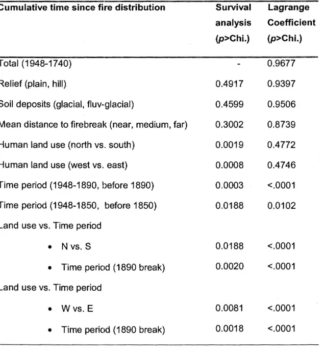
Table 1. Survival analyses and Lagrange probability results validating spatial and temporal influences while testing if the hazard of burning was constant with time.
Cumulative time since fire distribution Survival Lagrange
analysis Coefficient
(p>Chi.) (p>Chi.)
Total (1948-1740) 0.9677
Relief (plain, hill) 0.4917 0.9397
Soil deposits (glacial, fluv-glacial) 0.4599 0.9506 Mean distance to firebreak (near, medium, far) 0.3002 0.8739 Human land use (north vs . south) 0.0019 0.4772
Human land use (west vs. east) 0.0008 0.4746
Time period (1948-1890, before 1890) 0.0003 <.0001 Time period (1948-1850, before 1850) 0.0188 0.0102 Land use vs. Time period
•
N vs. S 0.0188 <.0001•
Time period (1890 break) 0.0020 <.0001 Land use vs. Time period•
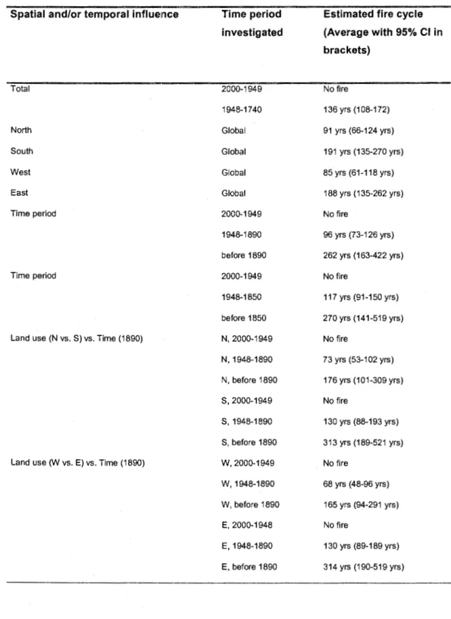
Wvs. E 0.0081 <.0001Table 2. Fire cycle estimates for different localizations and different time periods for TemiscaminguH, Quebec.
Spatial and/or temporal influernce
Total North South West East Time period Time period
Land use (N vs. S) vs. Time (1890)
Land use (W vs . E) vs. Time (1890)
Time period investigated 2000-1949 1948-1740 Global Global Global Global 2000-1949 1948-1890 before 1890 2000-1949 1948-1850 before 1850 N, 2000-1949 N, 1948-1890 N, before 1890 S, 2000-1949 S, 1948-1890 S, before 1890 W, 2000-1949 W, 1948-1890 W , before 1890 E, 2000-1948 E, 1948-1890 E, before 1890
Estimated fire cycle (Average with 95% Cl in brackets) No fire 136 yrs (108-172) 91 yrs (66-124 yrs) 191 yrs (135-270 yrs) 85 yrs (61 -118 yrs) 188 yrs (135-262 yrs) No fire 96 yrs (73-126 yrs) 262 yrs (163-422 yrs) No fire 117 yrs (91-150 yrs) 270 yrs (141-519 yrs) No fire 73 yrs (53-102 yrs) 176 yrs (101-309 yrs) No fire 130 yrs (88-193 yrs) 313 yrs (189-521 yrs) No fire 68 yrs (48-96 yrs) 165 yrs (94-291 yrs) No fire 130 yrs (89-189 yrs) 314 yrs (190-519 yrs)