Publisher’s version / Version de l'éditeur:
Vous avez des questions? Nous pouvons vous aider. Pour communiquer directement avec un auteur, consultez la première page de la revue dans laquelle son article a été publié afin de trouver ses coordonnées. Si vous n’arrivez pas à les repérer, communiquez avec nous à [email protected].
Questions? Contact the NRC Publications Archive team at
[email protected]. If you wish to email the authors directly, please see the first page of the publication for their contact information.
https://publications-cnrc.canada.ca/fra/droits
L’accès à ce site Web et l’utilisation de son contenu sont assujettis aux conditions présentées dans le site LISEZ CES CONDITIONS ATTENTIVEMENT AVANT D’UTILISER CE SITE WEB.
Technical Report (National Research Council of Canada. Ocean, Coastal and
River Engineering), 2018-04-30
READ THESE TERMS AND CONDITIONS CAREFULLY BEFORE USING THIS WEBSITE. https://nrc-publications.canada.ca/eng/copyright
NRC Publications Archive Record / Notice des Archives des publications du CNRC :
https://nrc-publications.canada.ca/eng/view/object/?id=46ba2a4c-b74f-4ca0-9562-fd56bb870a46 https://publications-cnrc.canada.ca/fra/voir/objet/?id=46ba2a4c-b74f-4ca0-9562-fd56bb870a46
Archives des publications du CNRC
For the publisher’s version, please access the DOI link below./ Pour consulter la version de l’éditeur, utilisez le lien DOI ci-dessous.
https://doi.org/10.4224/40000402
Access and use of this website and the material on it are subject to the Terms and Conditions set forth at
The Canadian winter road infrastructure and climate change
adaptation: prospective solutions through R&D
OCRE-TR-2018-004
Unclassified
The Canadian winter road infrastructure
and climate change adaptation:
Prospective solutions through R&D
Technical ReportOCRE-TR-2018-004
Paul Dominique Barrette
1200 Montreal Rd, Ottawa, ON K1A 0R6
April 30, 2018
Canada Canada
Ocean, Coastal and River Génie océanique, côtier et fluvial Engineering
The Canadian winter road infrastructure and
climate change adaptation: Prospective solutions through R&D
Technical Report
UNCLASSIFIED
OCRE-TR-2018-004
Prepared for:
Crown-Indigenous Relations and Northern Affairs (CIRNA)
Prepared by:
The National Research Council of Canada (NRC)
National Research Council Conseil national de recherches
Canada Canada
Ocean, Coastal and River Génie océanique, côtier et fluvial Engineering
The Canadian winter road infrastructure and
climate change adaptation: Prospective solutions through R&D
Technical Report
OCRE-TR-2018-004
Paul D. Barrette
[Frontispiece: Breakthrough of a snow plow on January 2011 in Northern Ontario [1]. Ice failure is attributed to a weaker ice cover.]
Executive Summary
In Canada, the cumulative length of the entire winter road network is estimated at 10,000 km. These are roads that are usable only in the winter – they run over land and across frozen water bodies (lakes, rivers and sea ice along coastlines and in bays). A large part of the challenge in managing that infrastructure stems from the extensive knowledge base that must be mobilized in order to gain a sufficient understanding of these roads. Unlike in the case of all-weather roads, nature provides winter roads with the foundation – frozen land and water surfaces –which needs to be trafficable and able to support the vehicles’ weight. These surfaces are particularly sensitive to climate change. Socio-economic factors of northern communities – low density, isolated populations, distance to other infrastructures (hospitals, schools) and cold winter temperatures – need to be carefully considered, as they are not typical of southern locations.
Winter roads are, in general, managed either by local communities, provincial/territorial governments or the industrial sector (e.g. mines, energy). In all cases, they need to be well planned and regulated. They tie in with other transportation infrastructures, such as all-weather roads, rail and air strips. New platforms – airships and hovercrafts – are being evaluated. Climate change may exacerbate issues that have traditionally affected over-land winter road operations, such as muskeg and permafrost. The main challenge for over-ice segments is the ice bearing capacity, either due to delays in achieving target ice thickness, or warmer ice. A large number of adaptation measures have been developed over the years, which can be applied at the planning, construction and maintenance stages, and for traffic management and access to ramps. These may be seen as a ‘band-aid’ approach – effective in many cases but insufficient to address the infrastructure as a whole and in the long term. For that purpose, increasing our basic
knowledge base is required, which is done through research and development (R&D).
R&D is a process involving targeted investigations using standardized procedures, and meant to provide answers the specific questions on which information is lacking (‘knowledge gaps’). They are typically conducted by research institutions and universities. R&D’s ultimate outcome is new information, which may then feed into guidelines, standards and working practices.
Avenues of investigation proposed in this report include a means to characterize winter roads in a more systematic fashion, namely with a field tool incorporating a ground penetrating radar and other instruments. Documenting the roads in that fashion should be combined with all available data on goods and people transportation, i.e. physical information combined with all operational and logistical data (e.g. opening and closure dates, nature of goods transported) in an interactive database. It is therefore a promising and potent tool for capacity and multimodal planning. The outcome would be made available to stakeholders, namely operators, users and analysts in transportation logistics. Another prospective R&D investigation avenue is to address the integrity of floating ice segments. Several outstanding questions regarding the bearing capacity and deformational behavior of floating ice roads should be addressed. Topics that need to be
investigated include: ice cover strength, how long a vehicle can be parked on the ice, how fast can a vehicle travel on the ice, how cracking patterns affect ice integrity, and what are the known procedures, techniques and technologies available to reinforce an ice cover. Answers to these questions would contribute to a safer usage of over-ice segments. These segments are very climate-sensitive, and a common weak link in an operation, causing delayed road opening at the beginning of the season, early closure at the end, and temporary closure mid-season. Also, the
consequences of breakthroughs can be significant – poorly designed or managed over-ice segments are a particular threat to life safety.
Drawing on these considerations, three recommendations are made: 1) The implementation of a system to gather data on road description and usage; 2) addressing the knowledge gaps outlined in this report; and 3) working toward nationally-consistent, more comprehensive winter road
Table of Contents
Table of Figures ... v
Table of Tables ... vii
1
Introduction ... 1
1.1 Objectives... 1
1.2 Methodology ... 2
2
The winter road infrastructure ... 3
2.1 Three governing elements ... 3
2.1.1 Nature ... 3
2.1.2 Society ... 3
2.1.3 Science and Engineering ... 5
2.2 Winter roads – A brief overview ... 5
2.2.1 Road opening and closure ... 6
2.2.2 Types of winter roads ... 8
2.2.3 Planning the road ... 10
2.2.4 Physical characterization of a winter road ... 10
2.2.5 Winter road management ... 11
2.2.6 Regulations and permitting ... 12
2.2.7 Multimodal transportation ... 14
2.2.8 Prospective new platforms ... 14
3
Challenges with the winter road infrastructure ... 18
3.1 Climate change ... 18 3.2 Over-land segments ... 19 3.2.1 Muskeg ... 19 3.2.2 Permafrost ... 20 3.3 Over-ice segments ... 21
4
Adaptation measures ... 25
4.1 Planning, construction and maintenance ... 25
4.2 Traffic management ... 26
4.3 Access to ramps ... 26
4.4 Summary ... 26
5
Increasing our knowledge base ... 27
5.1 The concept of ‘new knowledge’ ... 27
5.2 The concept of ‘R&D’ ... 27
5.3 Prospective R&D to improve winter road safety and effectiveness ... 27
5.3.1 Road characterization and usage... 27
5.3.2 Addressing the integrity of the floating ice segments ... 30
6
Discussion and recommendations ... 42
6.1 Documenting the Canadian winter road infrastructure ... 42
6.2 Filling in outstanding knowledge gaps in ice bearing capacity ... 43
6.3 Moving toward guidelines consistency ... 43
7
Conclusion ... 45
9
References ... 47
APPENDIX A
– Consultation outcome ... A1
APPENDIX B
– Gold’s formula ... B1
APPENDIX C
– Ice deformation ... C1
APPENDIX D
– Wave Patterns ... D1
APPENDIX E
– Summary of proposed investigations ... E1
Table of Figures
Figure 1: The winter road infrastructure is at a crossroad between three basic,
independent elements. See text for explanations. ... 4
Figure 2: Factors affecting winter road safety can be similar to those from other road
types
– this example is from Manitoba, and appears to be related to drinking and driving.
... 4
Figure 3: Simplified diagrams of an over-land (left) and over-ice (right) segments of a
winter road. ... 6
Figure 4: Ice cover thickening may be conducted using a pump to flood the ice (left) [19]
or implementing a spray ice system (right). ... 7
Figure 5: Snow cat plowing machine are preparing the large TCWR winter road operation
for opening (February 2018). ... 7
Figure 6: Historical closure dates of the Tuktoyaktuk-Inuvik winter road, showing a slight
progression toward an earlier closure [24]. Note that this road has recently been replaced
with an all-weather road. ... 8
Figure 7: The Hudson-Oka operation, owned by the Léger brothers
– it is one of the three
ice bridges crossing the Ottawa River between Ottawa and Montreal. ... 12
Figure 8: An airship designed by Lockheed Martin Corp., which is being considered to
supply mining operations in Northern Quebec. Approximate length is 100 m, 20-ton
capacity and cruising speed of 115 km/h. ... 15
Figure 9: Cost analysis of traditional ground transportation (winter roads and trucks)
compared to airships. Each
‘step’ in the ‘Airships’ trace corresponds to the addition of a
new unit to the fleet. ... 16
Figure 10: Top) The type of Hovercraft Agnico Eagle would like to use for some of their
activities in the NWT. Bottom) Hovercraft concept adapted for the needs to the Tibbitt to
Contwoyto winter road in the NWT [29]. ... 17
Figure 11: Mean temperature increase in the winter [Source: Ouranos Consortium in 40].
... 19
Figure 12: A piece of machinery that went through muskeg in Northern Manitoba. ... 20
Figure 13: Extent of permafrost in Canada (Source: The Canadian Encyclopedia). ... 21
Figure 14: Temperature, ice and operational data from the Yellowknife area [43] - Top) A
decreasing trend in FDD from 1943-2013. Middle) Measured ice thickness from
1959-2013. Bottom) Operating days vs FDD from 1994-2012. June 30 is considered the end of
the winter at these high latitudes. ... 22
Figure 15: Snowfall accumulation in the Yellowknife area from 1943-2012 [43]. ... 23
Figure 16: Breakthrough of a fuel tanker in the NWT. ... 23
Figure 17: Two other examples of ice breakthroughs from the NWT: Top) Crane lifting
an excavator that went through the ice near Kam Lake in the winter of 2017-2018.
Bottom) Snow Cat near Davidson Lake. ... 24
Figure 18: On-ice segment of the Inuvik-Tuktoyaktuk winter road in the NWT (April 18,
2012)
– a by-pass was set up to go around a breakthrough [Photo by A. Barker]. Note that
this road was replaced with an all-weather road, which officially opened in November
2017. ... 26
Figure 19: Left) The SmartQAMUTIK with its on-board ice thickness-measuring device.
Upper right) A GPR on a sleigh behind a vehicle [from 38]. Lower right) Example of a
GPR output [from 55]. ... 29
Figure 20: A block of ice showing clear ice (bottom of the ice block) and white ice (top
of the ice block), the latter with internal layering. ... 32
Figure 21: Recommendations from 14 sources, assuming a total ice thickness of 40 cm
made of clear ice and natural white ice in equal proportion and of questionable quality
[14]. Note the lack of agreement. ... 33
Figure 22: Several vehicles parked on the ice for fishing activities. ... 34
Figure 23: Schematic representation of a large vehicle traveling on a floating ice cover.
Top) Wave pattern below critical speed. Bottom) Wave pattern above critical speed.
Modified after Mesher et al. [19]. ... 35
Figure 24: Top) The TanDEM-X satellites that detected wave patterns in the ice.
Bottom) The wave pattern ahead and behind a vehicle (red dot) moving in the direction of
the yellow arrow. The black lines are the output of the theoretical modeling [77]. ... 36
Figure 25: Crack network inside an ice cover (boot for scale). The crack surfaces are
generally vertical, albeit with various orientations. ... 37
Figure 26: Two sources of cracking. Top) An overnight decrease in air temperature, for
instance from -5
oC to -20
oC as shown here, will induce a tensional regime in the upper
part of the ice cover, and result in cracking. Bottom) Repetitive loading from vehicles,
here as part of field testing (instrumentation in the orange huts) [74], will also induce
cracking. ... 38
Figure 27: Top) Example of an ice cover reinforcement with wooden logs [81].
Middle) The red dotted line is a geomembrane able to sustain additional load.
Table of Tables
Table 1: Types of winter roads [modified after 7]. ... 9
Table 2: Differences in winter road management structures. ... 11
Table 3: Investigation avenues proposed in this report. ... 28
Table 4: Example of a load table from an Ontario guidelines [56]. Note guidance toward
a proper value for the
‘A’ coefficient. ... 31
1
Introduction
In Canada, there are approximately 10,000 km of winter roads1. These are roads that are usable
only in the winter – they run over land and across frozen water bodies (lakes, rivers and sea ice along coastlines and in bays). They range in length from a few hundred meters to 100’s of kilometers, and are managed either by local communities, provincial/territorial governments or the industrial sector (mines and energy). Winter road users rely on them for their yearly supply of fuel, construction material and other bulk commodities that are too expensive for air
transportation. Winter roads are also used extensively for leisure activities such as ice fishing, snowmobiling and participation in sporting events (e.g. hockey tournaments, Dene hand games). Warmer winters cause winter roads to close, leaving communities stranded or mining operations running out of supplies – airlifting is very expensive [2-4]. According to McDonald [5], “[f]lying supplies to the mines costs four to eight times more per pound than transporting them by road.” Climate change is thought to increase the frequency and extent of warm winters. As such, it affects the safety and effectiveness of this infrastructure and reduces its yearly operational lifespan. A reduction in the number of freezing-degree days (FDD)2 is the most recognized
concern. Both over-land and over-ice segments are affected. Contractors and engineering
consultants have a wealth of knowledge and experience, and resort to various corrective measures to address the issues causing these closures. In parallel, as argued in the present report, there is a need for new Research and Development (‘R&D’) to improve our basic understanding of ice mechanics and hydraulics, which can be undertaken by research institutions such as the National Research Council and universities. The outcome of that R&D can then be used for input into manuals, standards and other such guidelines in the planning, design and usage of winter roads.
1.1 Objectives
The key objectives of this report are to provide:
A summary of the Canadian winter road infrastructure as a whole, and various related aspects, namely construction, management and regulations.
A brief definition/clarification of several notable concepts brought up by NRC during past discussions with INAC.
A summary of the challenges that this infrastructure is currently facing in the context of climate change.
An assessment of R&D investigation avenues that could be explored in moving forward with improving the effectiveness and safety of the winter road network.
A focus will be placed on segments over floating ice, for the following reasons: They are very climate-sensitive.
They are common weak links in an operation, causing later road opening at the beginning of the season, early closure at the end, and temporary closure mid-season.
The consequences of breakthroughs can be significant – poorly designed or managed over-ice segments are a particular threat to life safety.
1 This is a rough approximation which may be seen as an upper limit – about 8000 km are officially
recognized, plus an estimated 2000 km of industrial and community-based operations and sea ice roads.
2 This is the average number of degrees below freezing point summed over the total number of days in a
given time period. For instance, if the average air temperature on day 1, 2 and 3 was -5oC, -8oC and -12oC,
This report is written mostly from a science and engineering perspective (as opposed to sociological or economic). But this is done at a high level – the more technical material is confined to appendices – with abundant referencing where appropriate, in case the reader wishes to learn more about any particular topic.
1.2 Methodology
This report is the outcome of a desktop study. The information enclosed is based on NRC’s knowledge base in the properties, mechanics and hydraulics of river and lake ice, as well as soil mechanics and permafrost engineering. It also draws on the NRC’s publication archives, the Federal Science Library, an in-house ice engineering documentation center, as well as Internet search results.
No information is 100% reliable. Even technical papers and reports, including this one, are affected to some extent by author biases, pre-conceived ideas and oversights. Articles published in scientific and engineering journals are normally peer-reviewed, i.e. submitted manuscripts are critically assessed by third-party experts. Conference proceedings papers and reports are not usually peer-reviewed, or they are but less stringently – they may have been reviewed internally (within the author’s organization). Information found on the Internet varies significantly in quality and reliability. Newscasts by reputable organizations (e.g. CBC) are deemed trustworthy.
2 The winter road infrastructure
In this section, some background information is provided on a number of aspects related with winter roads, namely the nature of the infrastructure, what these roads are, how they are planned and built, an outline of the regulations, and how these roads relate with other transportation platforms.
2.1 Three governing elements
To better understand the challenges associated with winter roads, it helps to be aware of what is involved to make that infrastructure successful. In Figure 1, it is depicted conceptually as being at a junction between three basic, independent elements: Nature, Society, and Science &
Engineering.
2.1.1 Nature
Nature includes weather (temperature, wind and precipitations), foundation (soil, rock,
permafrost, etc.), hydrological processes, geography and fauna and flora. Natural reserves are an example of an infrastructure – this infrastructure is mostly concerned with Nature. Winter roads are much more dependent on that element than are all-weather roads (i.e. city streets and highways, gravel and paved country roads). This is explained below.
2.1.1.1 Foundations
Foundations are what lie below the road. Unlike for all-weather roads, the foundations for winter roads are not engineered – operators use what nature provides them with. The surface can be modified (e.g. surface flooding) and freezing can be promoted (e.g. by packing the snow), but there is no other control on ground type (rock, soil, etc.). Depth of frozen ground and ice
thickness are mainly of function of air temperature. However, a well thought-out route will allow terrain optimization, for instance, by avoiding south-facing slopes (more prone to melting due to sun rays),m lake areas where nearby streams are known to affect the ice thickness, or muskeg.
2.1.1.2 Topography and surface conditions
Motor vehicles have a wide radius of curvature, low clearance and limited traction. As a result, they require a wide right-of-way, shallow grades and relatively smooth surfaces. In fact, all-weather road designs are based on such limitations. For example, a considerable amount of funding is provided to reduce grades, notably through the extensive usage of heavy machinery, excavation tools and dynamite. Smooth surfaces are produced (i.e. pot holes are objectionable), such as asphalt, concrete and graded gravel. For winter roads, frozen ice covers do provide a flat and smooth surface, but this type of support for over-land segments is generally not available.
2.1.1.3 Air temperature
This is a decisive factor, since it controls extent and timing of freezing conditions.
2.1.1.4 Snowfall
Because of the limited amount of clearance, motor vehicles are vulnerable to any snow accumulation. While cities and highways benefit from highly effective winter maintenance equipment, that is not the case for winter roads, many of which are at remote locations and may not have the same level of financial and logistical support.
2.1.2 Society
This is an intricate and complex mixture of many tangibles and intangibles, e.g. economics, community living, access to health care, employment, public/private services. Schools are an
example of an infrastructure that is mostly concerned with that element. Parameters of interest in that case include population density, location, demographics, public access, governance, religious affiliation and security. Some of these factors come into play for winter roads as they do for all-weather roads.
Figure 1: The winter road infrastructure is at a crossroad between three basic, independent elements. See text for explanations.
Figure 2: Factors affecting winter road safety can be similar to those from other road types – this example is from Manitoba3, and appears to be related to drinking and
driving.
An example of a societal challenge is shown in Figure 2 – see also information contained in IBI Group [6]. Furthermore, an activity increase in the North is related with the development of new
3
resources (e.g. in the mining sector), community expansion and the opening of the northern seaway during part of the year. In Northern Ontario, for instance, the indigenous communities have strong population growth rates [6]. From that perspective, unless solutions to climate change effects can be found, winter road operators will have to do more with less in a foreseeable future.
2.1.3 Science and Engineering
For the purpose of this report, we will define science as knowledge of the behavior and physics of materials (solid, liquid, gas); engineering includes new operational methods, procedures and tools. Infrastructures that strictly involves the Science & Engineering element are rare – examples include astronomical observatories and particle colliders. Both study nature, but their design, conception, usage and maintenance is mostly independent of it. They are also mostly independent of society – parameters such as those that matter for schools (as listed earlier) are not a significant factor.
For winter roads, Science and Engineering is the knowledge required to plan, build, maintain and manage an operation. This is a function of budgetary constraints, and contributes significantly to the difference between an operation that is safe and effective and one that is less so. An
understanding of the winter road infrastructure has to draw from several areas of expertise, including:
Geotechnical engineering Ice hydraulics
Mechanical engineering Environmental sciences
Climate studies and physics of the atmosphere
Compared to all-weather roads and to other infrastructures, winter roads are not well understood. The reason for this is debatable. One important contributing factor could be the fact that, as mentioned above, a winter road is primarily nature’s creation. Unlike in the case of all-weather roads, it is nature, not humans, that provides winter roads with foundations – frozen land and water surfaces – that need to be trafficable. Another contributing factor is the number of studies done on winter roads, which is a small fraction of the number of those done on other
infrastructures.
2.2 Winter roads
– A brief overview
A winter road typically consists of segments that run over land and on floating ice surfaces (Figure 3). Each type comes with its own challenges in terms of planning, construction and safety. The over-land segments are underlain by soil that is frozen to a given depth, referred to as the ‘sub-grade’, itself underlain by bedrock, or permafrost at higher latitudes. The sub-grade can be overlain by snow or artificially-produced ice, used as a supporting surface and as a protection to the underlying vegetation. That ice may be produced with water tankers or from water pulled out directly from a nearby pond or lake. To increase thickness, water can be used to flood ice chips, to help increase ice buildup. The required thickness of that ice/snow layer depends on vehicle weight, weight distribution and frequency of passages.
Figure 3: Simplified diagrams of an over-land (left) and over-ice (right) segments of a winter road.
Segments running on floating ice take advantage of that material, which is naturally-available and leaves no environmental footprints upon melting in the spring. An ice cover is able to support a load because of the ice cover’s buoyancy and its resistance to flexure.
What controls the yearly operational lifespan, i.e. the parameters involved in road opening and closure, need to be carefully addressed, especially the weak links. For additional information, the reader is referred to Proskin et al. [7], itself based on Adam [8] and other guidelines [9-13]. Systematic comparisons between some of these guidelines are also available [6, 7, 14, 15].
2.2.1 Road opening and closure
Road opening is usually a function of the time required to grow a safe ice thickness, which itself depends on the maximum expected weight (e.g. some roads are meant to carry tractor trailers, other to only handle light vehicles). For over-ice segments, this is often achieved in two steps: The first step is removing the snow layer from the ice, so as to accelerate ice growth
[snow acts as an insulator – e.g. 16, 17]. This is done with light vehicles, once a safe thickness for these vehicles is achieved. Note that for over-land segments, the snow is left in place, so as to preserve a high albedo4 - it is compacted, thereby also reducing its
insulating effects, which accelerates ground freezing.
The second step is flooding the surface with water, or using spray ice, to artificially increase the thickness to the required target level (Figure 4).
Understandably, an optimum number of FDD at the beginning of the winter will favor an earlier opening – a well-explained example is provided by Hori et al. [18] for the James Bay Winter Road in Northern Ontario.
4 Albedo in this context is the amount of sunlight reflected by the ice/snow. If the ice/snow surface becomes
dirty, for instance when it incorporates sand, it absorbs the sunlight, which accelerates melting because of stored heat.
Figure 4: Ice cover thickening may be conducted using a pump to flood the ice (left) [19] or implementing a spray ice system (right)5.
Figure 5 shows snow cat vehicles leading the way to a February 8 opening in 2018 of the Tibbitt to Contwoyto Winter Road (TCWR). That is the road supplying the diamond mining industry in the NWT [20-23]. That road is also used extensively by the local communities for their own purposes.
Official road closure is when an operation ceases its activities. This varies from year to year – an example is shown in Figure 6. Road closure can be due to the deterioration of the over-land segments and its transition to the over-ice segments, for example, where the road is darkened by the soil. Because of the lower albedo, sun rays are absorbed, contributing to the increased melting. Softening of the over-ice surfaces can also be a factor, as it eventually impedes trafficability. Temporary road closure may also happen during the season, when a weak link becomes unusable and a diversion is not possible. Each winter road operation is different and there can be a number of factors contributing to a late opening, mid-season or end-of-season closure. Some operators may close their road because there is no longer a use for it.
Figure 5: Snow cat plowing machine are preparing the large TCWR winter road operation for opening (February 2018).6
5 http://www.cbc.ca/news/canada/north/yukon-river-ice-bridge-spray-suspended-1.4500692 6 http://www.cbc.ca/news/canada/north/tibbitt-road-opens-2018-1.4515200?cmp=rss
Figure 6: Historical closure dates of the Tuktoyaktuk-Inuvik winter road, showing a slight progression toward an earlier closure [24]. Note that this road has recently been
replaced with an all-weather road.
2.2.2 Types of winter roads
Table 1 provides an example of a classification for winter roads [7]. It should be pointed out, however, that the terminology used by winter road stakeholders is not uniform. For instance, ‘ice road’ and ‘ice bridge’ are often used to designate a winter road segment on floating ice [e.g. 8]. The information in the following section is from Proskin et al. [7].
2.2.2.1 Compacted snow road (C1)
This is natural snow that has been compacted enough to allow trafficability – it is the least expensive road. Compaction is done in various ways, notably with rollers and steel frame drags. They have limitations in terms of loads (less than 40 tons) and frequency (less than
1000 passages). In the years where snow fall is lower than usual, additional snow may be hauled from nearby locations. C1 roads are vulnerable to warm temperature and exposure to sunlight.
2.2.2.2 Over-land ice-capped snow road (C2)
C2 roads involve surface flooding and allow for the passage of heavier vehicles than C1 roads. The reason is that an icy surface is stronger and more resistant to wear than a snow surface. In places, the sub-grade can be directly overlain with that ice layer (i.e. without a snow layer). However, adding water to the compacted snow complicates the logistics – water tankers or trucks have to be involved and nearby sources of water have to be available. The operators may require permission from environmental authorities to use that water. Lower traction on C2 roads has to be taken into account in road planning, for instance when considering grades and vehicle
Table 1: Types of winter roads [modified after 7].
Terrain Road type Category Description Over-land Compacted snow
roads
C1 Road surface composed of compacted natural snow Ice-capped snow
roads
C2 Compacted natural snow that is ice capped using water Aggregate ice roads C3 Building ice surfaces by flooding
with water or harvesting and flooding ice chips (aggregate) Over-ice Floating ice road C4 Roads that follow floating ice
covers on lakes or rivers Grounded ice road C5 Roads that follow ice covers
grounded on a lake or river bottom
2.2.2.3 Over-land aggregate ice roads (C3)
Over-land aggregate ice roads will accommodate the highest vehicle weights and passage
frequency, and are suitable to uneven terrains. An additional step in building them is the recourse to ice chips that are flooded with water. The road builder makes use of tractors equipped with rippers. The ice is hauled and dumped at the location (as would be done with gravel for an all-weather road). The ice chip surface is then packed and saturated with water. This accelerates the rate of sub-grade thickening where it is required. C3 roads do not need a snow layer. Logistically, they are even more involved than C2 because they rely on the availability of water and ice, and may require permission from environmental authorities to access both.
2.2.2.4 Floating ice road (C4)
Frozen water surfaces are clearly a very practical medium for surface transportation. They are flat, require minimum maintenance and may run in a straight line (as opposed to over-land segments, which have to take into account topography and vegetation). The limiting factor is climate, mainly the air temperature (the number freezing-degree days – FDD) and amount of snow fall, since these factors are controlling the rate of ice growth. Human intervention can help increase that rate, i.e. by removing the snow cover, and thickening by flooding or spraying water over the ice surface. The consequences of a breakthrough in C4 roads remain a concern for winter road operators. Risk mitigation measures include adequate traffic management, ice thickness and quality.
2.2.2.5 Grounded ice road (C5)
Grounded ice roads lie directly on the river or lake bed, typically near the shorelines. The ice can be fastened to the bottom. Alternatively, at shoals (i.e. in shallow lake areas), and where the ice cover has been thickened to a sufficient extent by surface flooding, the ice can sink down and end up resting on the lake’s bottom. C5 roads are generally capable of supporting higher loads than C4 roads.
2.2.3 Planning the road
The following also draws from Proskin et al. [7].
2.2.3.1 Defining road requirements
These requirements are as follows:
Schedule and operating windows: What are the target road opening and closure dates. Traffic type and volume: What kind of vehicles (weight, size, axel load distribution) and
how many passages are expected.
Road right-of-way: This is the road width – requirements vary with road type, number of lanes, location, type of work involved (servicing communities, mines, seismic
program,…).
Environmental and regulatory requirements: See section 2.2.6.
2.2.3.2 Developing route options
Over-land options: This takes into account topography, water and snow requirements and the nature of the terrain (e.g. dry mineral soil is desirable; muskeg is not – see section 3.2.1).
Over-ice options: Parameters to be considered are currents (if any), availability of
portages and bathymetry, and water influx from nearby streams. Shallow areas and shoals can be objectionable, for instance, to address issues related with vehicle speed (see section 5.3.2.3).
2.2.3.3 Weather parameters
Temperature and snow fall for over-land segments: Historical records of freezing-degree days and snow fall are critical parameters - Proskin et al. [7] mention 300oC-days as a
minimum for ground freezing, and 5-10 cm of snow to support traffic.
Ice conditions: Similarly, historical ice thickness data should be consulted, along with freeze-up dates and ice cover disintegration/break-up dates.
Climate change: A handle on warming trends is also helpful to try to anticipate the expected number of FDD.
2.2.4 Physical characterization of a winter road
The physical nature of a winter road is highly variable. For overland segments, the parameters of interest include the following:
Foundation – soil, solid rock, gravel, muskeg, icy surface, permafrost.
Routing characterization – width, itinerary, radius of turns, grade, cross slope, slope direction, vegetation (e.g. shade vs no shade), creeks, obstacles (e.g. boulders, large trees).
For over-ice segments:
Foundation – Floating or grounded ice, length of segment. Hydrological – River versus lake, currents.
Ice thickness – This can be done by regular measurements or on continuous mode (profiling).
Ice cover – Lake ice versus columnar-grained ice, white ice versus blue ice7, pressure
ridges, cracks.
Routing characterization – Width, radius of turn, angle with shoreline. For the winter road as a whole:
Length – Over-land versus over-ice.
Structural bridges – Number, size, type, capacity.
Snow coverage – Thickness and extent (including bare segments).
Usage – One-way versus two-way, nature of traffic, cargo vs people transportation. Type of vehicles – Weight, clearance, turning radius.
Logistics – Weight stations, meteorological instrumentation, rest stations, gas pumps. These parameters are useful for the purpose of road planning and usage. Not all operations collect that information – means of obtaining it will be discussed later.
2.2.5 Winter road management
Winter road management structures in Canada fall roughly into three main categories (Table 2). The following is a brief description of each, based on the author’s consultation with a large number of stakeholders. This is a preliminary assessment; it is mostly qualitative – a systematic analysis with supporting data has yet to be compiled.
2.2.5.1 Provincial/Territorial
These roads are built and maintained by the government (namely Ontario, Manitoba, Saskatchewan, NWT), with support from engineering consultants. They generally abide by standard procedures for the construction, maintenance procedures and quality assurance, including monitoring of vehicle weights and ice thickness (for C4 and C5 segments).
Table 2: Differences in winter road management structures. Province or
Territory
Local communities Industrial sector
Level of funding Medium to high Low to medium Medium to high
Users Community members,
supply commercial vehicles Community members, supply vehicles Commercial vehicles
Main road types C1 to C5 C1, C4 C1 to C5
Yearly operational lifespan
As long as possible As long as possible Enough loads to supply required material
Main vehicle types All types of vehicles Automobiles, light
trucks and snowmobiles
Trucks of all sizes, from pickups to tractor trailers.
Main distribution(*) NWT, Manitoba,
Saskatchewan
Ontario, Quebec, Newfoundland and Labrador
Country-wide
Figure 7: The Hudson-Oka operation, owned by the Léger brothers – it is one of the three ice bridges crossing the Ottawa River between Ottawa and Montreal.
2.2.5.2 Local communities
These roads service community needs: access to work, school, health care, air strips, fishing and hunting grounds, leisure activities. Included are privately-owned ice bridges, an example of which is shown in Figure 7. Operations run by local communities may not be as consistent as those managed by governments and the industrial sector in terms of construction and maintenance procedures, rules-of-the-road and safety monitoring. Also, communities may or may not have the required funding or resources to fix or accommodate critical problems causing road closure.
2.2.5.3 Industrial sector
These roads, which include heavy duty industrial operations, are independently funded by the private sector, notably mining and hydro power companies. They are typically, though not always, for industrial usage, i.e. up to very heavy loads (40+ tonnes), for which in-depth analysis of load distribution (e.g. for axle spacing) and ice bearing capacity (on C4 and C5 road segments) is often conducted by specialized engineering and geophysical firms.
According to [7, p. 91], “Industrial winter roads will have more stringent requirements due to higher traffic loads and volumes, and have a higher level of monitoring and control that better assesses and meets risk management objectives”.
2.2.6 Regulations and permitting
As stated in Proskin et al. [7, p. 99], “[v]arious national, provincial, and territorial regulations apply to the construction, operation, and monitoring of a winter road, [many of which were] developed to mitigate negative environmental impacts on land and water”. Land use permits, issued by the federal government, include requirements, such as minimum snow cover, frost depth and the maximum amount of water that can be extracted from lakes and streams. For instance, Fisheries and Oceans Canada is concerned with developments affecting freshwater habitats. Examples of provincial and territorial requirements may include timber permits and water licenses.
For road usage in Ontario, the regulations of Ontario Highway Traffic Act apply – they are enforced by the Ontario Provincial Police [6]. There are currently no requirements for work permits when constructing a winter road. But for realignment, information (routing, mapping, archeological sites) is to be provided to the Ontario Ministry of Natural Resources and Forestry. Work permits are also required for new water crossings. Issuing of these permits is done in consultation with the local communities. Also, “[u]nder the Far North Act, 2010, most
development in the Far North of Ontario, including all-weather transportation infrastructure, is prohibited from proceeding in advance of a jointly approved community based land use plan for the area, unless an order is made to except or exempt an individual project. Where a community based land use plan is in effect, development must be consistent with the direction contained in the approved plan.” [6, p. 26]
Depending on the jurisdiction, factors that can be an issue for over-ice segments include [7]: Excessive sediment deposition related with the existence of a winter road. Means of protection include mitigation of soil erosion by ensuring stream banks have a shallow slope.
The presence of an ice bridge crossing a river, which may impede or modify the flow of water below it.
The extent to which fish habitats may be affected by the ice road.
For over-land segments, again depending on the jurisdiction, factors to be considered include: The volume of water needed for an ice-capped C2 or C3 road – a given threshold
(e.g. 10%) and a minimum water depth (e.g. 1.5 m) may be stipulated. Terrain stability – a dry, frost-stable soil is preferred.
Grades – the steeper the terrain, the more soil erosion. Higher grades promote soil erosion.
Permafrost (where it occurs), which is sensitive and should be used with caution.
The ground should be frozen to a minimum depth with a minimum snow cover thickness (to protect the vegetation).
Machinery should be used in a way that will not damage the terrain, for instance, by keeping bulldozer blades off the ground.
Snow windrows should not be continuous – they should have gaps, so as to allow the passage of wildlife (while also allowing meltwater to drain better in the spring). Issues to address for road closure include:
Removal of equipment and debris.
Ice bridge dismantling, so as to allow the river to flow freely when its cover begins to break-up in the spring.
A proper abandonment plan.
In Manitoba, as stated in Government of Manitoba [25, p. 33], “[a]n Environment Act Proposal Form must be filed before any construction is started on any new roads”. In that document [25], anyone involved in an accident during transportation of a contaminant is referred to the Federal Transportation of Dangerous Goods Act, and to the Manitoba Environment and Safety and Health. Included in the definition of ‘contaminant’ are:
Spills, leaks or fires involving chemicals such as pesticides or fertilizers. Radioactive material.
In Saskatchewan, “[a]n Environmental Assessment Approval must be obtained before any construction is started on any new overland road locations” [10, p. 33]. Anyone involved in an accident during transportation of a contaminant is referred to the Federal Transportation of Dangerous Goods Act. All environmental accidents are to be reported to the Spill Control Center. Contaminants are defined the same way as in Manitoba.
The above provide an idea of what may need to be considered, depending on the nature and location of the winter road operation.
2.2.7 Multimodal transportation
Multimodal transportation refers to the ability for people and goods to circulate across various transportation platforms – air, rail, road and marine8. In Canada, the winter road infrastructure is
part of that network. For instance, amongst its currently proposed objectives, Ontario’s Northern Ontario Multimodal Transportation Strategy (NOMTS)9 includes improving access to and by
remote communities and by northern industries, enhancing linkages to Southern Ontario and improving the safety of the network.
Multimodal transportation plays a key role in winter road planning and usage, as there are connections between these roads, all-weather roads, air strips and railways. Also, alternatives (typically, air strips) are critical to northern communities when a winter road becomes inoperative, for instance, to plan important supplies to be flown in. The transition between moving in and out of the winter road operational window also affects planning. Furthermore, the availability of alternative platforms needs to be considered in the medium to long term planning of a winter road network. Airships to supply northern communities, discussed further down, would be an additional transportation mode.
For an overall Canadian perspective on multimodal transportation, the reader is referred to [26].
2.2.8 Prospective new platforms
2.2.8.1 Airships
Airships (Figure 8), also called dirigible, have been in existence for about 150 years10. This
aircraft is essentially a self-propelled balloon filled with a gas whose density is lower than that of air – historically, this gas has been either hydrogen, later replaced by the helium which is non-flammable. Airships have been used by the German and British military during World War I, then for passenger transport until the 1930’s. Although they have been since superseded by fixed-wing aircrafts and helicopters for air transportation, soft shell helium-filled airships (known as
‘blimps’) are still being used for scientific and military purposes; they are also a well-known marketing tool. Airships are often designated as being ‘hybrid’, alluding to their dual lifting capacity – that is provided 1) by the lower density gas and 2) by the aerodynamic lift of an airplane. 8 https://northernontariommts.files.wordpress.com/2017/07/draft-northern-ontario-multimodal-transportation-strategy-executive-summary1.pdf 9https://nomts.ca/discussion-paper/#C1A 10 https://www.britannica.com/technology/airship
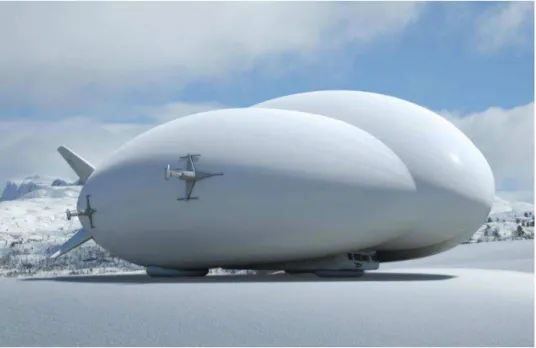
Figure 8: An airship designed by Lockheed Martin Corp., which is being considered to supply mining operations in Northern Quebec.11 Approximate length is 100 m, 20-ton
capacity and cruising speed of 115 km/h.12
There is currently a resurgence of interest for this platform. The viability of cargo and passenger airships as an alternative or complementary transportation platform to supply northern
communities has been investigated, notably in Northern Quebec13, Eastern Manitoba and
North-West Ontario [27] and between Churchill and Rankin Inlet14. Although winter roads are still
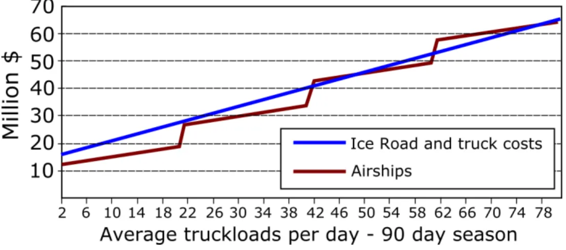
considered the most cost-effective option, this may not be the case for large tonnages (Figure 9).15
In that analysis, applied to a prospective connection between Rankin Inlet and Churchill, the cost for the initial build and yearly builds are $25M and $12M, respectively. Truck rates are 2.5 times that of those for all-weather roads – they are assumed to be $0.32 per tonne-kilometer, assuming an empty return. The yearly fixed cost per proposed airship is $8.3M, with about $3M to build a hangar. Cost per trip is assumed to be about $8k.
Combining airships with winter roads is also deemed a promising alternative [27]. According to Hori and Gough [28], Airbus Industries currently has a 40-tonne capacity prototype, with a $40M price tag per unit (compared to $75M for a A318)16.
11 http://business.financialpost.com/transportation/no-roads-no-problem-how-blimps-could-help-northern-quebecs-miners-overcome-their-infrastructure-woes 12 http://www.cbc.ca/news/canada/north/lockheed-martin-airships-1.3524549 13 http://business.financialpost.com/transportation/no-roads-no-problem-how-blimps-could-help-northern-quebecs-miners-overcome-their-infrastructure-woes 14 https://www.winnipegfreepress.com/opinion/analysis/ice-roads-airships-could-work-together-204044251.html 15 Ibid. 16 https://www.cnbc.com/2016/07/07/giant-blimp-like-airships-are-making-a-comeback.html
Figure 9: Cost analysis of traditional ground transportation (winter roads and trucks) compared to airships.17Each ‘step’ in the ‘Airships’ trace corresponds to the addition of
a new unit to the fleet.
The advantage of being able to airlift several tons of material to remote locations is certainly appealing. To the author’s knowledge, that concept has not yet materialized. It would have to be thoroughly proof tested before implementation, and would likely be used initially by the industry, given the high costs that are likely to be associated with this new northern platform.
2.2.8.2 Hovercrafts
McCartan and Kent [29] discuss an industrial design for a hovercraft meant to replace the trucks currently used to supply the diamond mine industry in the NWT (Figure 10). The rationale behind it was climate change and the challenges to come regarding such an important supply route – i.e. the sustainability of the Tibbit-to-Contwoyto winter road was considered in jeopardy. Several advantages in favor of hovercrafts were outlined [29]:
These vehicles would operate year-long because they are capable of traveling over land, water and ice.
For winter operation, the ice conditions, so critical for the trucks and other ground transportation vehicles with wheels, would be circumvented.
Hovercrafts would require minimum additional infrastructure, and would be allowed to load/unload cargo with the currently existing facility (Figure 10).
The hovercraft’s cargo capacity would be up to 54 tonnes, significantly more than the average truck payload (32 tonnes for the Tibbit-to-Contwoyto operation).
Hovercraft speed would be allowed to move at a higher speed than trucks, which has to do with their weight distribution on the ice cover.
It was estimated that, because of the cost savings for not having to build the current winter road every year, the cost of the proposed hovercraft would be recovered over a few years. Also, the year-round operation would reduce the number of hovercraft units to meet the demand for the required supplies.
17
Figure 10: Top) The type of Hovercraft Agnico Eagle would like to use for some of their activities in the NWT18. Bottom) Hovercraft concept adapted for the needs to the Tibbitt
to Contwoyto winter road in the NWT [29].
Note that the hovercrafts are currently used as ice breakers elsewhere [e.g. 30], for instance, to manage ice covers in the St. Lawrence River. Evidently, that would not be the purpose of those discussed here, which would be designed not to induce ice failure.
3 Challenges with the winter road infrastructure
The winter road infrastructure, like any other infrastructure in Canada, faces its own challenges. Each operation is distinct – plan and usage optimization should be envisaged on a case-by-case basis. To provide the reader with a perspective of what that means, Appendix A includes the outcome of a consultation by NRC with winter road operators in Northern Ontario, who provided information on the various issues that needed to be addressed. The reader is also referred to IBI Group [6] for an instructive compilation on this topic.
In this report, we will be delimiting our attention to general trends, including those brought about by climate change.
3.1 Climate change
Climate change is the consequence of global warming, which refers to the progressive rise in temperature of the Earth’s atmosphere documented over the last number of decades. At the planetary scale, this temperature rise is very small (a few degrees). But it has important
repercussions on the complex dynamics of the atmosphere and can have a significant impact on local weather patterns, including an increase or decrease, depending on geographical location, of the average air temperature. A large number of climatic models have been generated in an attempt to capture these temperature trends. Figure 11 is an example – it shows a rise in temperature over most of Canada in the winter.
There is an extensive amount of literature on climate change and impact on the winter road infrastructure. Following are some recent examples:
How it affects transportation, infrastructures and First Nations lifestyle in the Arctic [31, 32].
How it affects winter road operations [33-36].
How it affects the mining industry in Northern Canada [3, 22, 37, 38]. A projection of operational lifespan in the future [28].
The establishment of statistical links between FDD and winter roads opening dates [18]. Historical trends and how ice bridges on the St. Lawrence can be used as an index of
winter severity [39].
Risk to communities, e.g. ability to resupply and difficulty to plan because of unpredictable seasons conditions [1].
Two factors are associated with an increase in temperature:
Safety concerns: Delays in achieving target ice thickness will increase the likelihood of having users access the ice earlier than they should, because they are eager to use the ice and do not exercise due caution at that critical time of the year. This results in
breakthroughs.
Operational aspects: Issues that normally affect winter road operations (e.g. ground thawing, large snow falls, softening of the ice surface) on an occasional basis will recur more frequently because of climate change.
Figure 11: Mean temperature increase in the winter [Source: Ouranos Consortium in 40].
3.2 Over-land segments
Over-land segments have factors and issues that need to be properly managed by the road operator. The impact of climate change is mainly related with air temperature – a reduction in FDD would delay ground freezing. In the following, we will address two aspects of over-land segments that have traditionally been an issue with winter roads, which may be exacerbated by climate change.
3.2.1 Muskeg
Muskeg, an Algonquian word meaning ‘grassy bog’19, is also known as peatland. It is mostly a
mixture of organic material that is either alive (e.g. moss) or decomposing in an anaerobic environment (low oxygen). Its water table – the ground water upper surface – is near the surface and is therefore exposed to freezing in the winter. Its ability to sustain a vertical load depends on its composition – to avoid failure, one needs to ensure freezing depth is sufficient for the planned loads. In places, muskeg can be affected by water circulation. Moreover, because of extensive bacterial activity, whereby anaerobic conditions promote fermentation, muskeg is a methane-generating environment [41]. This gas is poorly soluble in water, and may contribute to the increase of ice porosity in the muskeg and a corresponding decrease in strength. Initial ice growth in muskeg is more sensitive to mild winters. Overall, the behavior of muskeg is mechanically unlike mineral soil. Winter road routing over this terrain requires careful consideration to avoid breakthroughs (Figure 12).
Figure 12: A piece of machinery that went through muskeg in Northern Manitoba.20
3.2.2 Permafrost
Permafrost, which is often associated with muskeg, is mostly found north of 60 deg. latitude (Figure 13), where population density is the lowest. However, it is very sensitive to disturbance and weather patterns, and is also affected by climate change [42]. Permafrost can be several hundred years old. It is divided into two layers: 1) an active layer that undergoes yearly freeze-thaw cycles; 2) a permanently frozen layer, extending several hundred meters in the colder regions, to a few meters where it is warmer. Permafrost is classified according to its distribution in terms of surface area it occupies at any given location:
Continuous (> 80%) Discontinuous (30-80%) Sporadic (<30%)
Even where it is discontinuous or sporadic, given this terrain’s sensitivity, it is a significant factor in winter road management.
Because winter roads are not used in the summer, they do not face the same engineering challenges of all-weather roads, which have to contend with a thawing active layer. In other words, the active layer below a winter road is always frozen, thereby protecting the permanent layer below. Nonetheless, in these areas, it is recommended to [7]:
Avoid ground known to be rich in ice. Avoid peat deposits and muskeg.
Plan the route so it runs over coarse grained soils, such as moraines and outwash areas. In areas of discontinuous permafrost, consider routing over south-facing slopes, which
may be devoid of permafrost.
Figure 13: Extent of permafrost in Canada (Source: The Canadian Encyclopedia21).
3.3 Over-ice segments
Over-ice segments correspond to winter road C4 type (Table 1). In wooded sectors, these roads may be more exposed to the sun compared to over-land segments, since the latter may be sloping toward the north or benefit from the shade from evergreen vegetation. They may also be affected by the wind and, in places, water currents. The foundation – frozen water – is thin relative to the water column below it. A significant difference between over-land and over-ice winter road segments is related with risks of breakthroughs and their consequences. These breakthroughs are recurring events – they may or may not result in a loss of life and equipment.
The effect of a reduction in the number of freezing-degree days may be observed at locations where there is sufficient climate and winter road operational data. An example is provided in Figure 14. It shows a gradual reduction in FDDs, its consequence on ice thickness and the number of operating days in the Yellowknife area [43]. Snow data are also presented in that source (Figure 15) – the reader will recall that, because of its insulation properties, snow also has an impact on ice growth.
From a road construction and maintenance perspective, early snow removal “represents the greatest risk of a possible breakthrough” [7]. Breakthroughs happen for a number of other reasons – Figure 16 and Figure 17 are examples. Since the mechanical strength and elastic behavior of an ice cover is influenced by air temperature and solar radiation [e.g. 44, 45], higher risks are also associated with road usage late in its operational time window.
From the perspective of ice road users, some statistics have been made available [46]. This source reported a total of 442 cold water immersion deaths in Canada from 1991 to 2000, involving falls through the ice. Of those, 55% were from snowmobiling, 11% other motorized vehicles, and 34% were tied with non-motorized activities. Breakthroughs can happen even on a well-regulated winter road and professional drivers [47]. In a number of cases, the information is not available22.
21 https://www.thecanadianencyclopedia.ca/en/article/permafrost/
22The author came across a case where information on a winter road operation was not released because of
Figure 14: Temperature, ice and operational data from the Yellowknife area [43] - Top) A decreasing trend in FDD from 1943-2013. Middle) Measured ice thickness from 1959-2013. Bottom) Operating days vs FDD from 1994-2012. June 30 is considered the end of
the winter at these high latitudes.
Figure 15: Snowfall accumulation in the Yellowknife area from 1943-2012 [43].
Figure 16: Breakthrough of a fuel tanker in the NWT.23
23http://www.cbc.ca/news/canada/north/truck-plunges-deline-ice-road-1.3477869. See also,
Figure 17: Two other examples of ice breakthroughs from the NWT: Top) Crane lifting an excavator that went through the ice near Kam Lake in the winter of 2017-2018.24
Bottom) Snow Cat near Davidson Lake.25
24 http://www.cbc.ca/news/canada/north/sewage-cleanup-kam-lake-fall-through-ice-1.4506144?cmp=rss 25 http://www.cbc.ca/news/canada/north/snowcat-breaks-through-ice-yellowknife-1.4518407
4 Adaptation measures
Adaptation measures are means of dealing with issues that adversely affect the effectiveness of a winter road operation – see Golden et al. [1] for a discussion on climate change ‘adaptation' concepts and how they differ from 'mitigation'26. Adaptation measures can be reactive – i.e. dealt
with as part of a maintenance and traffic management strategies, or they can be anticipatory – i.e. planned in advance [48]. Various sources of information discuss adaptation measures [3, 6, 15, 38, 49, 50].
4.1 Planning, construction and maintenance
Following is a non-comprehensive listing of adaptation measures – as can be seen, most apply to over-ice segments.
Extending the power grid to remote communities, so as to reduce their reliance on diesel fuel.
Laying structural bridges or permanent culverts at river and creek crossings when these become choke points.
Building all-weather road segments to replace problematic areas.
Planning route selection over the ice carefully – the shortest option may not be the best, because bathymetry has to be factored in.
Re-locating an over-ice segment to the land.
Building and maintaining multiple routes, in case one becomes unusable, or allowing contingency room for a by-pass, as required (Figure 18).
Conducting stress analyses to estimate ice bearing capacity under static or dynamic loads. Including improved standard operating procedures on ice that are embedded in contracts. Improving means of monitoring the ice thickness, notably by optimizing ground
penetrating radar technology, temperature and strength.
Limiting the size of windrows (snow banks on each side of the over-ice segment), which can cause a longitudinal crack to form in the center of the road.
Periodic monitoring of the ice surface, notably to detect wet cracks27.
Maintaining a minimum width for the road so as to allow the traffic to make its way around flooded areas.
Relying on spray ice at some locations where this method is better than surface flooding to help maintain or increase ice thickness.
Using snow on the ice surface to maintain a high albedo – that stored in snow banks can be used for that purpose, or from snow cache constructed and maintained for that purpose. Achieving a high albedo can also be achieved by laying out on the road surface, at
vulnerable locations, a light-colored artificial material (mats). Preventing the accumulation of dirt.
Covering the ice with a sufficiently thick layer of saw dust to insulate it against warm air temperatures.
Widening road corners to improve sightlines and increase safety.
26 In essence, mitigation and adaptation address the cause and the consequences, respectively, of climate
change. From Golden et al. [1], “[c]limate change mitigation is the reduction, prevention, and removal of greenhouse gases from the atmosphere, whereas adaptation is planning and preparing for climate change impacts to lessen the impact or capitalize on the opportunities” (p. 411).
27‘Wet cracks’ refer to cracks that allow water to seep up onto the ice surface. They indicate the crack has
reached the bottom surface of the ice (it spans the full thickness), thereby affecting ice cover integrity. ‘Dry cracks’ are those that do not penetrate the full thickness.
4.2 Traffic management
Using the road at night, while the ice is stronger. Restricting day time use of roads.
Enforcing speed limits. Driver awareness campaigns.
Allowing one lane to be faster for empty loads. Improving the overall traffic control.
Proper monitoring of vehicle weight.
Figure 18:On-ice segment of the Inuvik-Tuktoyaktuk winter road in the NWT (April 18, 2012) – a by-pass was set up to go around a breakthrough [Photo by A. Barker]. Note that
this road was replaced with an all-weather road, which officially opened in November 2017.
4.3 Access to ramps
The access to and from the ice cover (ramps) can be a weak link. Means of mitigating this include:
Considering north to east facing slopes for these ramps, which are not as exposed to the sun.
Maintaining a thick snow layer over the ramp throughout the winter, so that the bare ground does not become exposed.
Preventing exposure of that surface to the sun by covering it with a mat or other materials.
4.4 Summary
Adaptation measures may or may not apply to a given winter operation – it is a case-by-case scenario. None are the Holy Grail. But if any single one works, it can help improve the road’s effectiveness considerably. Many measures need to be implemented under the guidance of an experience operator or engineering consultants. These may be seen as a ‘band-aid’ approach – effective in many cases but insufficient to address the infrastructure as a whole.


![Figure 4: Ice cover thickening may be conducted using a pump to flood the ice (left) [19]](https://thumb-eu.123doks.com/thumbv2/123doknet/14045361.459543/20.918.145.791.107.328/figure-ice-cover-thickening-conducted-using-pump-flood.webp)
![Figure 6: Historical closure dates of the Tuktoyaktuk-Inuvik winter road, showing a slight progression toward an earlier closure [24]](https://thumb-eu.123doks.com/thumbv2/123doknet/14045361.459543/21.918.171.752.140.487/figure-historical-closure-tuktoyaktuk-inuvik-showing-progression-earlier.webp)
![Table 1: Types of winter roads [modified after 7].](https://thumb-eu.123doks.com/thumbv2/123doknet/14045361.459543/22.918.142.772.138.522/table-types-winter-roads-modified.webp)


![Figure 11: Mean temperature increase in the winter [Source: Ouranos Consortium in 40]](https://thumb-eu.123doks.com/thumbv2/123doknet/14045361.459543/32.918.227.698.103.490/figure-mean-temperature-increase-winter-source-ouranos-consortium.webp)
