HAL Id: hal-02047310
https://hal.archives-ouvertes.fr/hal-02047310
Submitted on 24 Feb 2019
HAL is a multi-disciplinary open access
archive for the deposit and dissemination of
sci-entific research documents, whether they are
pub-lished or not. The documents may come from
teaching and research institutions in France or
abroad, or from public or private research centers.
L’archive ouverte pluridisciplinaire HAL, est
destinée au dépôt et à la diffusion de documents
scientifiques de niveau recherche, publiés ou non,
émanant des établissements d’enseignement et de
recherche français ou étrangers, des laboratoires
publics ou privés.
in Argentina on the basis of field, mineralogical,
textural, and geochemical analyses
Thea Vogt, Norbert Clauer, Isabelle Techer
To cite this version:
Thea Vogt, Norbert Clauer, Isabelle Techer. The glaciogenic origin of the Pleistocene calcareous dust
in Argentina on the basis of field, mineralogical, textural, and geochemical analyses. Quaternary
Research, Elsevier, 2019, 91 (1), pp.218-233. �10.1017/qua.2018.74�. �hal-02047310�
Thea Vogta*, Norbert Clauerb, Isabelle Techerc
a
Friedrichstrasse 3, D-77694 Kehl, Germany
bInstitut de Physique du Globe de Strasbourg, Université de Strasbourg, F-67084 Strasbourg, France c
Equipe Associée 7352 CHROME, Université de Nimes, F 30021 Nimes, France (RECEIVEDJanuary 10, 2018; ACCEPTEDJune 12, 2018)
Abstract
Calcareous dust occurs in Argentina as layers and pockets closely associated with Pleistocene deposits and periglacial features from southernmost Patagonia to at least the Mendoza Precordillera and has been traditionally interpreted as a soil horizon resulting from postdepositional pedogenesis during interglacials. Detailedfield and microscopic observations and sedimentological and geochemical analyses of more than 100 samples collected from lower to upper Pleistocene deposits between 51°S and 33°S and from near sea level to 2800 m asl allow us to interpret the dust as synchronous with the host sediment. All observations and analyses lead us to conclude that: (1) the cryogenic morphology and the chemical signatures of the calcite component show that the dust is glaciogenic, (2) the dust was carried by southeasterly Antarctic winds, and (3) it was deposited over most of southern and central Argentina. Field observations, geomorphic evidence, and radiocarbon dates suggest that the dust was deposited during several Pleistocene glacial episodes.
Keywords:Calcareous dust; Cryogenic calcite; Pleistocene; Palaeoenvironments; Argentina
INTRODUCTION
Calcareous dust in close association with Pleistocene deposits occurs in Argentina from southern Patagonia to the Mendoza Precordillera, either mixed with the matrix or as fine layers, pockets, and infillings of thermal contraction wedges. Corte (1968), Corte and Beltramone (1984), Galloway (1985), and Grosso and Corte (1989) described periglacial features and the calcium carbonate (CaCO3) associated with them but did not
question its origin. Abraham de Vasquez and Garleff (1985), del Valle and Beltramone (1987), Buschiazzo et al. (1987), Bouza et al. (2007), Bockheim et al. (2009), and Ribolini et al. (2014) considered these calcareous accumulations as soil hor-izons linked to warm interglacial periods. The relationship between the periglacial features in the host material and the occurrence of CaCO3was never addressed.
New information about the origin of these calcareous materials results from detailed observation of many outcrops ascribed to the lower to upper Pleistocene in Patagonia, the western Pampa, and the Paramillo de Uspallata in the
Mendoza Pre-Cordillera at elevations from near sea level up to 2800 m asl, and from the samples of both the host material and the calcareous silt collected there. Microscopic and sedimentologic observations were carried out on more than 100 samples, and geochemical analyses were made for 24 of them (Techer et al., 2014). The strontium isotopic data and the distribution patterns of the rare-earth elements (REEs) clearly indicate a similar glaciogenic origin for the dust col-lected all over Argentina. Some of the most demonstrative exposures studied and the results of the laboratory analyses of samples collected there are detailed here.
As a preliminary statement, we note that leaching does not result in a loose micrite, and a loose calcareous material mixed with thefine matrix or in thin layers and pockets is not typical of pedogenic horizons. For instance, the CaCO3at all
sites examined is independent from the surface soil and appears at various depths between carbonate-free layers, which excludes deposition from local percolating solutions. Also, the dust is intimately associated with the cryogenic deformations as cryoturbations or thermal contraction wedges, which makes postsedimentary penetration and crystallisation difficult to justify in a material strongly com-pressed and having undergone cryosuction. A supplementary
*Corresponding author at: Friedrichstrasse 3, D-77694 Kehl, Germany. E-mail address: thea.vogt@gmail.com (T. Vogt).
fact is that, whatever the depth of the calcareous layers, colonies of calcified saprophyte fungal hyphae and sporae forming felts occur within. This means that calcitisation took place while the fungus was alive or immediately after its death before decay, as shown by Klappa (1979). While fungi are found in soils at various depths, they only sporulate in the uppermost millimetres, indicating a subaerial environment. Therefore, the calcareous dust in which they lived must have fallen at the ground surface. This evidence supports the hypothesis that this calcareous silt is not pedogenic, but related to a dust fall over the region. Two questions arise from these observations: Where did the dust come from? How and when was it deposited? Recollection, comparison, and discussion of all available arguments about the alternative pedogenic or glaciogenic nature of the calcareous dust spread over most Argentina therefore appear justified and timely.
FIELD OBSERVATIONS
Four sites from those already described in Vogt (1992), Vogt and del Valle (1994), Vogt and Corte (1996), Vogt and Lar-qué (1998), Vogt et al. (2010), and Techer et al. (2014) were chosen: Pampa del Castillo and Puerto Madryn in eastern Patagonia, Carapacha Chica in the western Pampa, and Paramillo de Uspallata in the Mendoza Precordillera (Fig. 1). They show that, despite the differences in latitude, elevation, age, and geologic and geomorphic context, the
calcareous dust and its deposition mode appear to be the same everywhere.
Eastern Patagonia
This nearly 300-km-wide coastal belt forms a landscape of terraced Pleistocene gravel that incises a basement of Tertiary continental and marine sediments. At leastfive terraces descend gently in steps oriented southwest to northeast from 750 to 590 m asl at the Pampa del Castillo to 125 to 90 m at Puerto Madryn (42°45′S) 400 km away. All are covered by a 10- to 105-m-thick alluvial mantle called “Rodados patagónicos,” “Tehuelche,” or “Patagonian shingle” (Windhausen, 1924; Sylwan, 2001; Martínez and Kutschker, 2011) consisting of well-worn gravel of acid volcanic pebbles. Decimetre-sized cobbles with typical glacial parallel-piped shapes are visible in the well-layered and channeled, seldom cross-bedded, deposits with nofine-grained lenses and settling channels, the fine matrix being entrapped in the gravel. The sedimentary features suggest strong and regularflows, like those of a glacial discharge, car-rying a voluminous load of coarse material over long distances (Urien et al., 1993; Ponce et al., 2011). The alluvial gravel is capped until about 400 km inland by calcretes 20 to 60 cm thick. They consist of calcite with the same mineralogical and geo-chemical characteristics as those of the underlying calcareous dust. They are soft, except for their hard upper portion (20–25 cm), and appear centimetrically bedded, each layer showing its own network of desiccation cracks, thus intraformational. Decimetric cryoturbation folds involving several layers at once are visible, which evidently formed when the material was still plastic. The general features suggest an active layer above per-mafrost (Vogt and del Valle, 1994).
Pampa del Castillo
The entire surface of the Pampa del Castillo has been exten-sively disrupted in the last decades by oil exploration and extraction, so that the exposure here described has been destroyed. Therefore, we rely in this presentation on observa-tions we made before the oil companies moved in. A gravel pit revealed at least 3 m of“Rodados” undisturbed at the bottom, but affected in the upper 2 m by thermal contraction wedges filled with gravel and fine matrix mixed with 30% to 60% loose calcite and silica concretions. The gravel appeared strongly compressed between the wedges, and some cobbles were coated by opal. The deposit was capped by a 30- to 50-cm-thick calcrete consisting of 40% to 80% CaCO3. Del Valle and
Beltramone (1987) described three profiles in this area but did not mention the wedges. (Figs 1, site 1, and 2)
Puerto Madryn
The lowest alluvial level of Puerto Madryn slopes by 0.16 %, heading to a base level of −150 m that corresponds to the lowest sea stand during the last glacial maximum (LGM). The bedrock consists of Miocene sandstone. A loose sandy layer is spread across the whole terrace. An outcrop by the roadside exposes a 2-m-deep and 0.5- to 0.6-m-wide thermal
Figure 1. Map of Argentina with the location of Mendoza (M), Buenos Aires (BA), Bahia Blanca (BB), Puerto Madryn (PM), Comodoro Rivadavia (CR), and Rio Gallegos (RG). The white arrows and numbers indicate the sites studied: Pampa del Castillo (1), Puerto Madryn (2), Carapacha Chica (3), Paramillo de Uspallata (4). The dotted line delimits the emerged continental shelf during the glaciations.
contraction wedge (Corte and Beltramone, 1984). Filled with vertically arranged pebbles, sand and calcareous dust, it dis-rupts the bedrock (Figs. 1, site 2, and 3a).
Nearby, a gravel pit studied by del Valle and Beltramone (1987), Vogt (1992), Vogt and del Valle (1994), and Vogt and Larqué (1998) shows“Rodados” more than 3 m thick. The deposit is clearly stratified and contains thin white lenses of clay and silica concretions. Cryogenic folds and com-pressionfigures disturb the layering. Several generations of thermal contraction wedges, 2− 3 m apart and each buried by gravel beds, occur, allfilled with gravel, sand, silica concre-tions, and calcareous dust that is strictly associated with the cryogenic deformations, whereas it is absent in the undisturbed layers at the bottom of the section. The CaCO3content increases
downwards from 28% to 48% in the wedges, associated with the<2 µm clay-size fraction that increases from 18% to 40%, which is typical of permafrost conditions (Corte, 1962, 1963). A continuous calcareous duricrust with 57% to 73% CaCO3
tops the sequence (Figs. 1, site 2, and 3b).
Carapacha Chica exposure in the western Pampa
The western part of the Pampa extends between 40°S and 35°S and from 63°W to 65°W in the eastern foreland of the Andes chain. It represents the southernmost extension of the Brazilian craton and is composed of metamorphic and intrusive rocks (granites, diorites) together with Paleozoic and Permo-Triassic sediments. Following the uplift of the Andes chain, this region was shaped in a pediment that is gently inclined eastwards. During the late Miocene, from 11 to 5.3 Ma BP, the pediment was blanketed by siltites, a sandy silt slightly cemented by silica, free of carbonate, with a loess-like structure and containing globular or elongated siliceous concretions. Pleistocene basaltsflowed across the upstream portion of the pediment; hence it is called the Basaltic Meseta. Terraced sandy alluvium capped by siliceous duricrusts covers the whole pla-teau (Vogt et al., 2010). Calcareous dust is present in thefluvial deposits and over the basaltflows.
The Sierra Carapacha Chica is a basement outcrop of hard Permian arkosic sandstones located at the southwestern margin
of the plateau (37°31.683′S, 66°24.550′W). At the bottom of the north-facing slope, a 3- to 3.5-m-high outcrop exposes a gelifluction accumulation of shattered rock. The basal portion is free of CaCO3and is overlain by layers slightly indurated by a
fine matrix containing 20% to 25% CaCO3between
carbonate-free layers. A siliceous duricrust tops the sequence (Figs. 1, site 3, and 4).
Paramillo de Uspallata
The Paramillo de Uspallata (32°00′S, 69°00′W) is a high plateau between 3200 and 2700 m asl in the Mendoza Pre-cordillera that possibly represents the eastern portion of the early Miocene planation surface uplifted to 6000 m in the Frontal Cordillera (Ramos and Cortes, 1993). The bedrock consists of upper Keuper sediments, mostly schists inter-bedded with rhyolites and sandstones, and upstanding dacite dykes. No evidence of glaciers older than the middle Pleistocene has been reported on the eastern side of the Andes further north of Patagonia. Between 33°S and 36°S, where the chain is the highest, the oldest glaciation (“Uspallata glaciation”) is ascribed to the early middle Pleistocene (Espizua and Bigazzi, 1998; Espizua, 2004), which means
Figure 2.An exposure in the Pampa del Castillo terrace (45°07′S, 68°04′W), but no longer exists due to human modification. The calcareous dust is mixed with the gravels. A series of contraction wedges are visible. The spade indicates the scale.
Figure 3.Two exposures in the Puerto Madryn level (42°44.750′ S, 65°15.950′W). (a) A 2-m-deep thermal contraction wedge breaks up and folds the Miocene sandstone (studied by Corte and Beltramone [1984]). It isfilled with alluvial gravel from above and calcareous dust. (b) View of a>3-m-high gravel pit that exposes a series of thermal contraction wedges that disturb the alluvial deposit. Near the bottom, a gypsum crust (“g”) is related to a postglacial water table;“c” is the calcrete.
that no glacier existed at the Paramillo de Uspallata during the early Pleistocene.
Periglacial processes reshaped the surface during the Pleistocene glaciations to a cryopediment 3 by 12 km wide covered by a thick gelifluction deposit spread on a smooth surface and incised by sporadic gullies. The upper portion of the deposit is visible over several hundred metres in banks about 2 m high on the road from Villavicencio to Uspallata (“ruta de los Caracoles”). Beside some poorly sorted boulders up to 50 cm in length, dacite clasts 1–20 cm across are mixed with a matrix of finely disaggregated dacitic brown-ochre sand. Devoid of CaCO3, the bottom is overlain by the same
materials, made whitish by the presence of calcareous dust. A layer of small cryoclasts in an ochre-coloured, carbonate-free sandy matrix mixed with reddish clay forms an intermediate layer. Coarse gravel and boulders with a carbonate-rich matrix in an upper layer suggest some runoff. Fine gravel in a greyish-brown matrix and a sandy, silty, and
humic surface soil cap the sequence. The whole profile dis-plays cryoturbation features such as folds and extrusions and particle sorting with the finest fraction increasing down-wards. The CaCO3content can be as much as 55%, and
cal-citic pendants at the lower face of gravels showing congelation features are frequent (Vogt and Corte, 1996). The cryopediment contains the largest amounts of calcareous dust, but calcareous silt and calcitic pendants also occur in a nearby rock glacier by the road at 1800–1100 m asl, and the same kind of gravels are sparse all along the slope following the deep incision that leads to the valley bottom several hundred metres further down (Figs. 1, site 4, and 5).
CALCAREOUS DUST
Wherever collected, the calcareous dust consists of a loose material that crumbles easily even when consolidated. Its proportion in the host sediment is variable but never less than 10% by volume and can amount to 70% in some pockets. It consists offine-grained calcite (2 to 5 µm, micrite).
Microscopic characteristics
Owing to the size of its particles, thisfine material is best observed by scanning electron microscopy (SEM). The cal-cite appears as very well preserved, loose rhombohedral and scalenohedral idiomorphic crystals. Traces of dissolution only appear in the vicinity of fungal colonies. Recrystallisa-tions with typical congelation features (Vogt, 1990; Vogt and Corte, 1996) occur in the gelifluction deposits. Round frosted and nail-scratched quartz grains typical of wind activity are mixed with the dust. Grains of sodium chloride and gypsum, clearly of allochtonous origin relative to the local bedrock, are also present. Littoral glossy ovoid quartz grains and ooids occur in the samples from eastern Patagonia. The quantity and homogeneity of the material all over Argentina is remarkable, whatever the nature of the bedrock, host sedi-ment, and surrounding slopes (Figs. 6–9).
Figure 4.The Carapacha Chica exposure (37°31.683′S, 66°24.550′W). The gelifluction deposit consists of shattered siliceous sandstone mixed with scarce matrix. The clasts are angular and heterometric. The white material (“c”) is CaCO3. The deposit is capped by a
duricrust (“d”). The hollows are bird nests in the soft calcareous accumulation below the duricrust. The spade at the bottom gives the scale.
Figure 5. An exposure by the Ruta de los Caracoles, at the Paramillo de Uspallata: two carbonate-rich layers in the gelifluction deposit affected by folds, underlined by the black and the white dashes. The hammer in the middle gives the scale.
Origin of the calcite
Limestone outcrops occur all along the Andean chain, and the waters of rivers and lakes contain some CaCO3but massive
precipitation of calcite is currently not observed, and if it occurs it is never powdery. The solubility of CaCO3increases
when the temperature decreases, and therefore the colder the water, the higher the concentration of CO2; close to 0°C the
content of CaCO3can reach 299 mg/L (Ek and Pissart, 1965).
Calcium concentration in glacial water is also high relative to other cations (Anderson et al., 1997). Calcite represents up to 20% of the glacial rockflour, even if the parent rocks contain very little CaCO3 (Bukowska-Jania, 2007). When glacial
rivers once discharged from subglacial environments meet subzero air temperatures, calcite precipitates by freezing as loose micrite with crystalline rhombohedral or scalenohedral shapes (Fairchild et al., 1996; Clark and Lauriol, 1992; Zák et al., 2004). A glacial origin in a cold environment may therefore be assumed for this powdery calcite.
To verify this hypothesis, strontium, carbon, and oxygen isotopic analyses, as well as REE distribution patterns were determined on 24 samples collected from Rio Gallegos (51°30′ S) to Paramillo de Uspallata (≈32°S). The ∂13C values obtained range from−1.9 to −7.2‰ (VPDB) and match with previously published values of Argentinean calcareous dust (Mercer, 1983; del Valle and Beltramone, 1987; Zech et al., 2011), which
confirms a continental, but not necessarily a pedogenic origin. Del Valle and Beltramone (1987), for instance, reported∂13C between−3.7‰ and −8.7‰, clearly outside those of pedogenic carbonates, which usually range between −8‰ and −12‰ (e.g., Salomons and Mook, 1976). Margaritz et al. (1981) also published∂13C values of pedogenic calcite of paleosols from about 22 to 1.7 ka BP in Israel, showing that except for the∂13C of the oldest calcite at−2.6‰ (±1.9), the other 11 published values range from−7.7‰ (±0.4) to −11.7‰ (±1.3), which is, again, clearly outside the range reported by Techer et al. (2014). Later, Cerling and Quade (1993) showed that the ∂13C of pedogenic calcite correlates with the contents of C3and C4in
each soil ecosystem. In fact, the∂13C values from a compilation of C3and C4plants ranged from about−20‰ to −33‰ for the
former and from about −9‰ to −17‰ for the latter, sig-nificantly off the values from −1.9‰ to −7.2‰ obtained for the calcareous dust studied here. In turn, the carbon isotopic com-position of pedogenic carbonates does not simply result from that of the minerals from which they precipitated (Salomons and Mook, 1976), as crystallisation temperature and isotopic com-position of the interacting solution also impact the carbonate ∂13C. This latter relationship between pore water moving
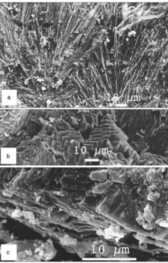
Figure 6.Scanning electron microscopy photographs showing the calcite within the calcareous dust: Calcite crystals with scalenohedral shape from (a) the Paramillo de Uspallata and (b) the Carapacha Chica exposure, with incipient cryogenic crystallization in the centre. The shape of the calcite is the same in all studied sites.
Figure 7.Cryogenic lamellar crystals: (a) dendritic assemblage of needles growing from calcitic dust; (b) the lamellar crystals assemble together to form needles; (c) detail of the lamellar crystals.
through a soil and crystallising calcite was confirmed by the identical87Sr/86Sr ratios for both (Thellier and Clauer, 1989). In fact, each pedogenic calcite yields the specific isotopic signature of soil solutions that integrate all soluble elements before pre-cipitating the authigenic calcite. This can in no way be the case for the calcareous dust studied here, as most Argentine deposits hosting carbonate dust do not reflect homogeneous conditions. Also, there is a clear gap between the∂13C data obtained for the calcareous dust and the values that characterize pedogenic calcite.
An alternative interpretation has to be provided, which has never been done in all earlier publications referred to previously. For instance, C3and C4plants almost contemporaneous with the
LGM, such as those found in Australia, did not necessarily release∂13C that was taken up by soil carbonate resulting in a pedogenic signature (Quade et al., 1995). In fact, it has not yet
been proved that such C3and C4plants were contemporaneous
with the calcite dust of Argentina. Furthermore, no solid argu-ment has been given until now about the transfer of invariable ∂13C from plants to authigenic calcite. In summary, there is no
reason to doubt that the ∂13C values from −1.9‰ to −7.2‰ (VPDB) refer to a glacial origin for the carbonates analyzed (Techer et al., 2014), unless sustainable contradictory arguments that are still missing are provided.
The narrow range of the 87Sr/86Sr ratio from 0.706463± 0.000008 to 0.707477 ± 0.000006 (2σ) reported for the carbonate dust (Techer et al., 2014) represents another essential argument against a pedogenic origin. Indeed, it has been known for a long time that there is no way to correlate a constant87Sr/86Sr ratio with a pedogenic process. The deposits described earlier are derived from varied bedrock sources, from basic volcanic rocks and acidic plutons to marine sediments of ages from the Paleozoic to the Triassic, that have a wide spectrum of mineral composition over the area of interest. The constitutive minerals of such
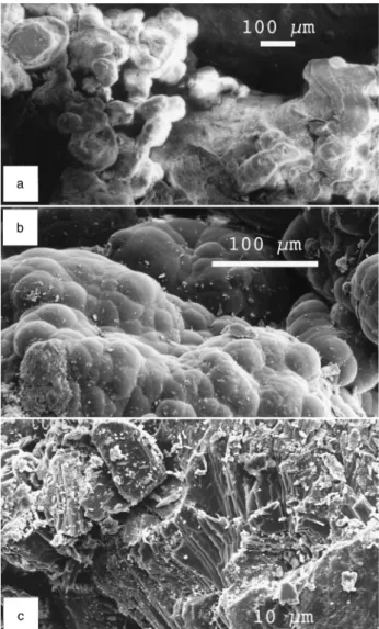
Figure 8.Scanning electron microscopy photographs showing the colonization of the calcareous dust by fungi: (a) and (b) calcitized fungal hyphae; (c) a cluster of calcitized sporae.
Figure 9.Scanning electron microscopy photographs showing (a) a cluster of ooids cemented by calcite; (b) neoformed opal; (c) gypsum platelets, a cryogenic structure also observed in Antarctica (Vogt and Corte, 1996).
sediments are variably affected by weathering, and they release strontium with variable87Sr/86Sr ratios that definitely cannot fit within the homogeneous overall 87Sr/86Sr ratio obtained for the observed calcite. Of all the arguments against a glaciogenic origin of the calcareous dust, this is probably the most difficult one to deny, ignore, or discard. Ultimately, no valid argument could explain homogeneous 87Sr/86Sr generated from sediments derived from such varied bedrock over such a wide area as is considered here.
Last but not least, the REEs of the carbonate dust yield constant patterns with, importantly, a specific negative cerium anomaly (Techer et al., 2014). Again, the homogeneity of a geochemical signal for the carbonate dust all across Argentina, together with its negative cerium anomaly, is a supplementary determining argument. Indeed, continental calcite from any kind of soil does not yield the negative cerium anomaly that is rather representative of minerals crystallising in contact with seawater. In turn, both the87Sr/86Sr ratio and the negative cer-ium anomaly require crystallisation in a large, homogeneous reservoir with seawater supply during periodically similar epi-sodes and not in continental soils affected by pedogenic weathering that are necessarily heterogeneous.
There should always be more data than those available to consolidate a demonstration, but here the combination of the
14
C ages that will be discussed later, the combined ∂13C values, the87Sr/86Sr ratios, and the REE distribution patterns point consistently to the same origin for the calcareous dust.
Age of the calcareous dust
The calcareous dust was observed in all deposits ascribed to the Pleistocene by geologic and geomorphological evidences. Paramillo de Uspallata is the oldest Pleistocene formation in the Mendoza Precordillera, according to Harrington (1941). As it is at a higher elevation than the middle and late Pleistocene features at about 2000–1500 m
asl, and as the bottom of the nearest valley is at about 2000 m asl, this formation could be of lower Pleistocene age. Sylwan (2001) ascribed the alluvial cover of the Pampa del Castillo, the oldest and highest terrace in littoral Patagonia, to the Great Patagonian glaciation (GPG; 1.17 to 1.02 Ma). The alluvium covering the plateau and its surroundings in the western Pampa contains basalt debris and is therefore of Pleistocene age. Geomorphological considerations place it between the lower and the middle Pleistocene (Vogt et al., 2010).
Using14C dating, Corte and Beltramone (1984) estimated the age of the CaCO3collected at about 1 m below the surface
in the Puerto Madryn level to be 27.2± 0.3 ka BP in the outer parts of the wedge and 22.7± 0.5 ka BP in the central part. These ages correspond to the LGM. Additional 14C ages reported by del Valle and Beltramone (1987) in the nearby exposure are within the same time range: 36.5± 2.5 ka BP at about 2 m below the surface and 24.3± 0.95 ka BP at about 1 m below the surface. These ages agree with the estimates of Mercer (1983) and Zech et al. (2011). Farther southwest in Patagonia, Bockheim and Douglass (2006) obtained
239U–230Th ages of 224, 209, and 24 ka for carbonate rinds
that they did not describe, which correspond to glacial periods.
Corte (1968) described succinctly an exposure about 12 km to the south of Rio Gallegos (≈51°30′S), along the road to Punta Arenas at 20 m asl. Gravel appears well layered at the bottom, whereas it is strongly disturbed between 120 and 60 cm below the surface by thermal contraction wedges filled with sand, 50 to 60 cm deep and about 1.5 m apart. The gravel between the wedges is strongly compressed, forming involutions. A line of ventifacts, perhaps a lag pavement, occurs between the contraction wedges and the sandy surface layer. Whereas the gravel at the bottom and the sand in the wedges are devoid of CaCO3, two layers containing
calcar-eous dust are visible in the cryoturbated gravel between the
Figure 10.Wind circulation over Argentina. (a) The present-day circulation in a surestada situation: the black arrows indicate the polar wind, the white arrows represent the tropical wind. (b) The proposed wind circulation during the glacial times, according to the situation of polar ice and polar front as described by several authors.
wedges. Corte provided us with two samples from those two layers for chemical analyses. CaCO3 content amounts to
20%, the calcite is the same loose micrite as described else-where, and many round aeolian-shaped grains are present in the coarse (>600 μm) sand fraction. The wedges and sand infilling are evidently younger than the underlying gravel and calcareous dust, but no 14C ages are available. Despite a closer proximity to Antarctica, the periglacial features are far less conspicuous than those in Puerto Madryn. A cold epi-sode (Antarctic cold reversal) occurred between 14.8 and 12.6 ka BP at 50°S (Moreno et al., 2009; Murray et al., 2012), with freezing temperatures all year round to the south of this latitude (Marsh and Ditlevsen, 1997). Heusser (1989) and Rabassa et al. (2005) also dated a last glacial occurrence at about 11 ka BP in the Beagle Channel near Ushuaia. The sand wedges andfillings at Rio Gallegos could then belong to this late cold episode.
Once more, it appears that the dust originated under glacial conditions. The next question is: Does it correspond to the climatic and edaphic environment of the glacial times in Argentina?
CENTRAL AND SOUTHERN ARGENTINA
DURING THE GLACIAL EPISODES
The Andes Mountain chain and Antarctica are the two major features controlling the climate of southern and central Argentina. When the upper Miocene (≈11 to 5.3 Ma) gla-ciations of Antarctica caused an expansion of the ice sheet with a resulting global fall of the sea level (Flower and Kennett, 1994), the climate of southern Argentina became colder and drier. A major glaciation affected southern South America at some time between 7 and 4.6 Ma (Mercer and Sutter, 1982). Clapperton (1993b) and Rabassa et al. (2005) reported at least eight glacial episodes during the middle and upper Pliocene, and the GPG between 1.17 and 1.02 Ma was followed by 14 to 16 cold events until the LGM, which occurred from about 26.5 to 19 ka BP. The LGM began ear-lier in the southern Andes, about 39 ka according to Zech et al. (2011), which is consistent with the earlier estimation of Mercer and Laugénie (1973).
The Antarctic ice growth covered the southern portion of the Atlantic Ocean and resulted in a 100–50 m drop in sea level below the present-day level. During the LGM, the Antarctic grounded ice reached the shelf edge (Anderson et al., 2002; Graham et al., 2010; Ingólfsson, 2004; Cofaigh et al., 2014), while the Antarctic sea ice expanded to 60–48°S (present position 70–60°S), doubling its surface area and reducing the surface area of the southern Atlantic Ocean (Crosta et al., 1998; Crosta, 2009; Guilderson et al., 2000; Violante et al., 2014). Currently at 50–53°S, the Austral polar front shifted about 5–6° northwards (Paskoff, 1967; Caviedes and Paskoff, 1975; Clapperton, 1994), towards 51°S (Garcia et al., 2012), even to 45°S (MARGO, 2009), with a correlated 4–6°C cooling of the ocean surface (Gersonde et al., 2005; Kaiser et al., 2005) and a 5–8°C drop near Argentina (Hulton et al., 2002; Kull et al., 2003). In fact, little is known about the
temperatures on the South American continent. For instance, Pérez-Alberti et al. (2005) estimated the thermal depression at 11°C and even 13°C during the LGM in Tierra del Fuego. Alternatively, Kohfeld and Harrison (2001) considered that atmospheric models have underestimated the magnitude of cooling and drying of much of the land surface during the LGM.
Cold temperatures, extension of glaciated areas, and a decreased ocean surface all restricted evaporation with a concomitant estimated decrease in precipitation of 50% in Antarctica (Jouzel et al., 1989). The fall in sea level exposed the continental shelf and widened the continental surface area. The Argentinean shoreline shifted several hundred kilometres eastwards (640 km to the south of Santa Cruz according to Ponce et al. [2011]), increasing in turn the continentality of the climate. In any case, the fall in sea level caused the water tables to drop, which intensified the ambient aridity. Central and southern Argentina were cold deserts (Iriondo and Kröhling, 1995), much drier than the present-day cold deserts, as evaporation was lower and the air was drier.
The presently submerged eastern continental shelf was a vast plain on which rivers much larger than those of today were fed by more extensive glaciers (Cavallotto et al., 2011) and deposited gravel extensively. It is known from sub-marine exploration that the continental shelf containsfluvial valleys, braided river networks, blowouts, lagoons, and deltas, in addition to loess and glaciofluvial materials interlayered with and capped by calcretes (Clapperton, 1993a; Urien et al., 1993; Violante et al., 2007, 2014). The emerged marine platforms were described as marginal deserts (Ochsenius, 1985). The ice-free regions suffered a harsh cold climate, and permafrost formed near sea level in southernmost South America (Benn and Clapperton, 2000). Therefore, it is almost certain that rivers fed by glacial out-wash at the outlet from the Andes deposited calcite-rich sediment on the alluvial plains and wide barren surfaces that emerged as sea level fell. The submarine landscape of the Argentinean shelf was similar to current periglacial deltaic plains such those of the Yukon or Lena Rivers, where river and marine waters mix.
PEDOGENIC INTERPRETATION OF THE
CALCAREOUS DUST: A DISCUSSION
The authors who suggested that the calcareous deposits resulted from leaching and concentration of the CaCO3in soil
horizons that they called BCa, K, or petrocalcic also assumed
that this process took place during the warm and wet inter-glacial periods. This interpretation calls for several remarks. First, the homogeneous characteristics, especially the constant87Sr/86Sr of the calcite studied, could not be gener-ated by pedogenesis, as pedogenic evolution depends strongly on the bedrock. The studied samples were collected on a wide area extending from 51°S (Rio Gallegos) to 32°S (Paramillo de Uspallata) and from near sea level up to 2800 m asl, with a variety of bedrocks comprising Palaeozoic granite
calcite is intimately mixed with the host materials and is often impure, containing iron oxides, for instance. Pedogenic leaching and associated recrystallisation do not produce loose crystals, but often produce heterogeneous concretions or nodules of various sizes. Andfinally, it is difficult to consider that solutions could percolate easily through sediments strongly compressed by thermal contraction.
Second, the authors seem to have disregarded not only the fact that the calcareous dust is closely linked with cryogenic features, but also that the features they consider as indicative of pedogenesis, such as coatings, pendants, and concretions, can be produced by freezing as well.
For instance, Cailleux (1965, 1967, 1968) described cryogenic deposits of calcium carbonate, silica, and iron oxides within Würmian formations from Europe and the permafrost of Alaska, Yakutia, and Antarctica. Adolphe (1966, 1972) obtained calcitic pendants on a limestone gravel by experimental congelation; interestingly, the calcite crystals were rooted in the cortex, which was decarbonated. In natural conditions, Vogt (1977) reported identical features on the gravels of a Würmian terrace in southern France. Further SEM examination revealed the peculiar micro-morphology of the cryogenic calcite crystals, far different from pedogenic (vadose) pendants (Vogt, 1989). Later, Vogt and Corte (1996) described calcitic pendants and fringes in the permafrost of Antarctica, the Mendoza Pre-Cordillera, and southern Siberia.
As for silica, in addition to the cryogenic siliceous crusts reported by Cailleux (1965) in Antarctica and Siberia, Hallet (1975) described subglacial calcium carbonate and silica deposits coating the bedrock. In the terrace near Puerto Madryn studied here, opal coatings occur on volcanic grav-els. SEM and energy-dispersive spectrometer analyses showed that silica derived from the inner gravel, which was hollowed; the same was observed for magnesium, iron oxide, and aluminium (Vogt, 1990). The explanation for both cryogenic calcitic pendants and opal coatings and con-comitant impoverishment of the gravel are explained by the strength of the cryogenic suction: 1.2 MPa (≈10 atm)/ − 1°C at−10°C = 10.2 MPa (≈100 atm).
Concerning the silica concretions, which are ubiquitous in glacial age deposits in Patagonia, they result from a different process. Smectite, the dominant clay mineral in these deposits, loses its aluminium, the fate of which in permafrost conditions remains to be investigated. The impoverished
glaciations until the present (e.g., Mercer, 1968; Iriondo and Garcia, 1993; Andres et al., 2003; Glasser et al., 2004; Bor-romei et al., 2007; Haberzettl et al., 2007; Aniya, 2013). In summary, the climate was dominantly dry with polar winds reaching Amazonia (Kronberg and Benchimol, 1992; Ser-vant et al., 1993; Carneiro Filho et al., 2002). A mantle of sand was spread over Argentina during the late glaciation and early Holocene (Carignano and Cioccale, 2005), which is confirmed by luminescence dating of dune fields in San Luis Province (≈33°S) (Tripaldi and Forman, 2007, 2016). The lower portion of this aeolian formation has been dated at 11– 8 ka BP in Buenos Aires Province (Tonni et al., 1999). This sand cover is 50–100 cm thick and occasionally thicker, forming sheets and dunes in Patagonia and the western Pampa, but no radiometric or luminescence dating is avail-able for those areas. According to Tonni et al. (1999), the climate was dry and cool during the early Holocene (11–8 ka BP). Paez et al. (1999) considered the environmental condi-tions to be extremely arid, with precipitation lower than 200 mm before ca. 11 ka BP and effective moisture increas-ing between ca. 11 ka BP and ca. 10 ka BP, probably related to an increase in precipitation to about 200 mm under cold conditions. The edaphic moisture was lower than today dur-ing the late Pleistocene and the early and middle Holocene (Pendall et al., 2001), and most of the Holocene (12 to 0.8 ka) was characterised by drier than present conditions, according to Tripaldi et al. (2016).
Dry climate means that there is little movement of water through the soil and little leaching of solutes. Bouza et al. (1993), for instance, described a centimetre-thick surficial crust formed by raindrop impact with redeposition by rain-wash on top of an upper zone of laminated sand containing silt and clay with large empty vesicles, and a dense lower zone with fewer and smaller air vesicles. Vesicular soil hor-izons reduce infiltration (Turk and Graham, 2011) from 3- to 100-fold decline (Young et al., 2004), so this structure indi-cates lateral rather than vertical transport. The 14C age of 5440± 160 yr BP for the calcareous dust in the early Holo-cene sand cover (del Valle and Beltramone, 1987) confirms that no recrystallisation occurred during the late millennia (from 5440± 160 yr BP to the present). Wetter and milder phases are only recorded in eastern and northern Pampa and in northern Argentina, where the climate is driven by a northeastern atmospheric circulation. The geographic situa-tion was identical during the previous interglaciasitua-tions, and it
can be assumed that the climatic conditions were not so different.
Finally, the great proportion of CaCO3 in the deposits
presumes a massive mobilisation and crystallisation of cal-cite, and its good preservation, which is difficult to consider in warm and wet environments. This good preservation of calcite is better explained during glacial periods, when atmospheric CO2decreased drastically (Jouzel et al., 1989;
Kotlyakov et al., 1991; Caillon et al., 2003) with a lower effect on carbonate recrystallisation. Andfinally, such a loose material resisted all climatic changes during the whole of the Pleistocene, confirming the persistence of an arid environ-ment. The lack of dust deposits in the eastern and northern Pampas and in northern Argentina, where the climate is warmer and wetter, then becomes understandable. If calcar-eous dust was also deposited in those regions, which is likely, it could have been weathered and leached away under wetter and warmer local conditions, as was the case during the interglacial episodes elsewhere, and still is the case according to the literature (Sayago, 1995; Sayago et al., 2001; Zinck and Sayago, 1999, 2001).
GLACIOGENIC AND AEOLIAN
EXPLANATION
In summary, the calcareous dust is intimately associated with the periglacial deformations of the host material. Locally, calcite may be recrystallised as cryogenic fringes. Radio-carbon dating of the younger deposits places them within the LGM. Microscopic and chemical analyses show that the calcite characteristics are homogeneous in all occurrences and that it was deposited at the ground surface, as proved by fungal colonisation.
All evidence points to the following succession: (1) increased solubilisation of CaCO3 under cold conditions
leading to a carbonated glacial outwash; (2) CaCO3
crystal-lisation under cold temperatures as idiomorphic micrite crystals; and (3) remobilisation of calcite as dust across the region.
How did the calcareous dust form?
The huge volume of calcareous dust could form only on a wide continental area allowing crystallisation of large amounts of homogeneous carbonates, an area necessarily located near the ocean, as interactions with seawater are assumed from REE distribution spectra. The Argentinean shelf is one of the largest submarine platforms in the world, stretching from 35°S to 55°S, over 170 to 850 km, and cov-ering about 1 million square kilometres. Its depth is 110 to 165 m with a smooth eastward slope (Violante, 2001), so the shelf emerged as an immense littoral plain when the sea level dropped by 100 to 150 m during glacial maxima (Rabassa et al., 2005; Ponce et al., 2011). Walter et al. (2000) showed that the Argentinean shelf was an important source for wind-transported silt during the glacial periods, while Basile et al. (1997) reported87Sr/86Sr ratios for sediments of this
Argentinean continental shelf to be within the values of the glaciogenic calcareous dust of the same area (Techer et al., 2014). The climate cooled slowly, more effectively on the continent than on the wide ocean, allowing mountain glaciers to extend more rapidly than sea level fell. The glaciofluvial discharge containing calcium (and strontium) was deposited over the alluvial plains on aflat, frozen, and muddy surface and under shallow water in lagoons. During the glacial episodes, the CaCO3transported to theseflat estuarine areas
by the rivers was dissolved due to water temperature and pH changes. Calcium concentrated again afterwards and crystallised into new authigenic, chemically homogeneous calcite in an environment that had slightly varied strontium isotopic ratios depending on the ratio of fresh/seawater during crystallisation.
Role of wind
However, these facts do not explain the natural dispersion of the calcareous dust across all geomorphic surfaces of Argentina. For instance, glacial outwash could not flow across the geomorphic levels of the western Pampa and Paramillo de Uspallata, because there were no glaciers upstream and obviously no glaciogenic calcite. How chemi-cally homogeneous calcite could have been dispersed over more than 20° in latitude even up to the mountain chains at 2800 m asl has to be explained. Wind seems not only a plausible carrier of the material, but also the only reasonable explanation for such a wide horizontal and vertical spread.
Arguments to strengthen an aeolian hypothesis come from microscopic analysis, which reveals that the material contains wind-transported littoral grains and allochtonous minerals associated with the calcareous silt. Yet deflation requires wide surfaces made offine-grained materials devoid of vegetation: presently, most aeolian dust comes from desert regions. Several authors invoked an aeolian supply for the calcareous silt in the exposures they observed in Argentina, for example, Buschiazzo et al. (1987) in the western Pampa and Bockheim et al. (2009) and Ribolini et al. (2014) in the southernmost Patagonia, with-out proposing a possible source area. Ribolini et al. (2014) suggested southwesterly winds, yet the westerlies reaching Patagonia come from the southern Pacific Ocean and, according to Blisniuk et al. (2005), deposition in the eastern foreland of the southern Patagonian Andes had essentially ceased by≈14 Ma as the result of a rain shadow caused by the Miocene surface uplift. The only periods of extensive desert areas in Argentina occurred during glaciations.
Currently, the belt of westerly winds extends over the Southern Hemisphere from about 40°S almost to Antarctica. Oriented orthogonally to these winds, the Andes create an orographic barrier, with heavy precipitation on the western Chilean side and a marked drought on the eastern side with a föhn effect. Two powerful winds blow over southern and central Argentina: the cold and dry pampero from the southwest and the surestada from the southeast, carrying cold and wet polar air. The surestada sometimes reaches the Amazonian basin, but once on the continent it is stopped by
point of the mountain chain, and its already limited influence on the eastern side vanished. The distance between polar and tropical belts narrowed, thereby steepening the pole-to-equator temperature gradient and, consequently, the wind strength (Petit et al., 1999; Compagnucci, 2011; Crouvi et al., 2010). Southeasterly winds were reinforced (Latrubesse and Ramonell, 1994; Shi et al., 2000; Stuut et al., 2002; Kim et al., 2003). The littoral quartz grains and ooïds found together with the calcareous dust in the LGM terrace of Puerto Madryn, when the shore was more than 200 km to the east, suggest strong winds (Fig. 10). The deflation of the calcareous dust and its transport over thousands of kilometres on the continent by strong and dry winds sweeping over the desertic plains covered by glaciofluvial deposits fits this context well. Under long-lasting cryogenic conditions, rock debris suffers comminution to the 50–10 µm silt grain size (Konishchev, 1982). Quartz is the most fragile because its microfissures are about 1–10 µm apart and can be reduced to the limiting size of solid particles, about 1µm (Schwamborn et al., 2012). This grain size is well adapted for wind deflation and explains the fineness of the glacial dust observed in Argentina and also collected in the Antarctic ice. Petit et al. (1999), Legrand et al. (1988), Jouzel et al. (1989), Kotlyakov et al. (1991), Fischer et al. (2007), and Reader et al. (2012) evaluated the amount of dust in the atmosphere during the cold periods to be at least 15 times more than the amount seen now, because the wind was so much stronger. Delmonte et al. (2007) estimated that dustfluxes during the last five inter-glacials were reduced 10- to 25-fold compared with dust fluxes occurring during glacial periods.
The geographic source of the dust contained in the Antarctic ice has been often assumed as derived from southern South America (Basile et al., 1997; Delmonte, 2003; Delmonte et al., 2004, 2011; Fischer et al., 2007; Li et al., 2008). According to Ackert (2009), most of the dust in the Antarctic ice cores came from the glacial outwash of Patagonia. Sugden et al. (2009), Albani et al. (2010, 2011), and McCulloch et al. (2000) also considered South America to be the main source for the dust during the LGM, because of the extension of glaciogenic dust sources on active outwash plains, as well as a likely more efficient transport to West Antarctica. Delmas and Petit (1994), Kaiser and Lamy (2010), and Weber et al. (2012) emphasised the role of the emerged shelf. Li et al. (2010) considered that the extension of the dust source caused by the lower sea level was two to three times greater than that due to the reduction of
1995; Clapperton et al., 1997; Moon, 2008). These lakes were frozen during winter and melted in summer. There were not enough barren surfaces to supply dust towards Antarctica, and it is difficult to identify the wind circulations that would have been responsible for the transfer.
CONCLUSIONS
Field observations as well as laboratory analyses prove that the calcareous dust associated with Pleistocene periglacial features of central and southern Argentina is of glacial origin, transported by and precipitated from river waters over the alluvial plains to the emerged continental shelf, where it recrystallised and was deflated and dispersed by winds during the cold episodes. The observations detailed herein provide also information about the environment during the glacial periods. The role of reinforced Antarctic southeasterly winds, for instance, was minimised in previous publications, whereas it has been asserted in the southeastern Atlantic (Kim et al., 2003). Alternatively, the calcareous concentrations in soils of central and northern Argentina could have resulted from secondary precipitation of CaCO3 after weathering
under warmer and wetter postglacial conditions.
ACKNOWLEDGMENTS
One of us, T. Vogt, did thefieldwork with A. Corte and H. Vogt, both of whom have since passed away. We remember the animated dis-cussions in thefield and the outcomes that we report here. We also acknowledge thefield organisation and cooperation of the teams of CENPAT in Puerto Madryn and the University of La Pampa in Santa Rosa. And we are grateful to the senior editor and to the two reviewers whose remarks and suggestions helped to improve our text.
REFERENCES
Abraham de Vazquez, E.M., Garleff, K., 1985. Fossil periglacial phenomena in the central and southern part of the Piemont of Mendoza Province, Argentina. Zentralblatt Geologie Paläonto-logie, Teil I: Allgemeine,Angewandte, Regionale und Historische Geologie 1, 1709–1719.
Ackert, R.P. Jr., 2009. Palaeoclimate: Patagonian dust machine. Nature Geoscience 2, 244–245.
Adolphe, J.P., 1966. Etude de quelques cristallisations provoquées par gel expérimental. Cahiers Géologiques 79–80, 911–917.
Adolphe, J.P., 1972. Obtention d’encroûtements carbonatés par gel expérimental. Comptes-Rendus de l’Académie des Sciences de Paris 274, 1139–1142.
Albani, S., Mahowald, N., Delmonte, B., Maggi, V., 2010. Changes in mineral dust transport and deposition to Antarctica between the Last Glacial Maximum and current climates: modelling concen-tration, size and provenance. Geophysical Research Abstracts 12, EGU2010-4680, 2010, EGU General Assembly Vienna 2-7 May, 2010.
Albani, S., Mahowald, N., Delmonte, B., Maggi, V., Winckler, G., 2011. Comparing modeled and observed changes in mineral dust transport and deposition to Antarctica between the Last Glacial Maximum and current climates. Climate Dynamics 38, 1731–1755.
Anderson, J.B., Shipp, S.S., Lowe, A.L., Wellner, J.S., Mosola, A. B., 2002. The Antarctic Ice Sheet during the Last Glacial Maximum and its subsequent retreat history: a review. Quatern-ary Science Reviews 21, 49–70.
Anderson, S.P., Drever, J.I., Humphrey, N.F., 1997. Chemical weathering in glacial environments. Geology 25, 399–402. Andres, M.S., Bernasconi, S.M., McKenzie, J.A., Roht, U., 2003.
Southern Ocean deglacial record supports global Younger Dryas. Earth and Planetary Science Letters 216, 515–524.
Aniya, M., 2013. Holocene glaciations of Hielo Patagónico (Patagonia Icefield), South America: a brief review. Geochemical Journal 47, 97–105.
Baker, P.A., Seltzer, G.O., Fritz, S.C., Dunbar, R.B., Grove, M.J., Tapia, P.M., Cross, S.L., Rowe, H.D., Broda, J.P., 2001. The history of South American tropical precipitation for the past 25,000 years. Science 291, 640–643.
Basile, I., Grousset, F.E., Revel, M., Petit, J.R., Biscaye, P.E., Barkov, N., 1997. Patagonian origin of glacial dust deposited in East Antarctica (Vostok and Dome C) during glacial stages 2, 4 and 6. Earth and Planetary Science Letters 146, 573– 589.
Benn, D.I., Clapperton, C.M., 2000. Glacial sediment–landform associations and paleoclimate during the Last Glaciation, Strait of Magellan, Chile. Quaternary Research 54, 513–523.
Berner, R.A., 1968. Calcium carbonate concretions formed by decomposition of organic matter. Science 159, 195–197. Blisniuk, P.M., Stern, L.A., Chamberlain, C.P., Idleman, B., Zeitler,
P.K., 2005. Climatic and ecologic changes during Miocene surface uplift in the Southern Patagonian Andes. Earth and Planetary Science Letters 230, 125–142.
Bockheim, J., Coronato, A., Rabassa, J., Ercolano, B, Ponce, J., 2009. Relict sand wedges in southern Patagonia and their stratigraphic and paleo-environmental significance. Quaternary Science Reviews 28, 1188–1199.
Bockheim, J., Douglass, D.C., 2006. Origin and significance of calcium carbonate in soils of southwestern Patagonia. Geoderma 136, 751–762.
Borromei, A.Z., Coronato, A., Quattrocchio, M., Rabassa, J., Grill, S., Roig, C., 2007. Late Pleistocene–Holocene environments in Valle Carbajal, Tierra del Fuego, Argentina. Journal of South America Earth Sciences 23, 321–335.
Bouza, P.J., del Valle, H.F., Imbellone, P.A., 1993. Micromorpho-logical, physical, and chemical characteristics of soil crust types of the central Patagonia region, Argentina. Arid Soil Research and Rehabilitation 7, 355–368.
Bouza, P.J., Simón, M., Aguilar, J., del Valle, H., Rostagno, M., 2007. Fibrous-clay mineral formation and soil evolution in Aridisols of northeastern Patagonia, Argentina. Geoderma 139, 38–50.
Bukowska-Jania, E., 2007. The role of glacier system in migration of calcium carbonate on Svalbard. Polish Polar Research 28, 137–155.
Buschiazzo, D.E., Martínez, H.M., Peinemann, N., 1987. Con-diciones paleoclimáticas deducidas de indicatores pedológicos y geomorfológicos en la región pampeana central (Argentina). Zentralblatt für Geologie und Paläontologie 1, 875–883. Cailleux, A., 1965. Quaternary secondary chemical deposition
in France. Geological Society of America Special Paper 84, 125–138.
Cailleux, A., 1967. Actions du vent et du froid entre le Yukon et Anchorage, Alaska. Geografiska Annaler 49, 145–154. Cailleux, A., 1968. Periglacial of McMurdo Strait (Antarctica).
Biuletyn Peryglacjalny 17, 57–90.
Caillon, N., Severinghaus, P., Jouzel, J., Barnola, J.-M., Kang, J., Lipenkov, V.Y., 2003. Timing of atmospheric CO2 and
Antarctic temperature changes across Termination III. Science 299, 1728–1731.
Carneiro Filho, A., Schwartz, D., Tatumi, S.H., Rosique, T., 2002. Amazonian paleodunes provide evidence for drier climate phases during the Late Pleistocence–Holocene. Quaternary Research 58, 205–209.
Cavallotto, J.L., Violante, R.A, Hernández-Molina, F.J., 2011. Geological aspects and evolution of the Patagonian continental margin. In: Palaeogeography and Palaeoclimatology of Patago-nia: Implications for Biodiversity. Special issue, Biological Journal of the Linnean Society 103, 346–362.
Caviedes, C.N., Paskoff, R., 1975. Quaternary glaciations in the Andes of north-central Chile. Journal of Glaciology 14, 155–170. Cerling, T.E., Quade, J., 1993. Stable carbon and oxygen isotopes in soil carbonates. In: Swart, P.K., Lohmann, K.C., Mckenzie, J., Savin, S. (Eds.), Climate Change in Continental Isotopic Records. Geophysical Monograph Series 78. Wiley, New York, pp. 217–231.
Clapperton, C.M., 1993aNature of environmental changes in South America at the Last Glacial Maximum. Palaeogeography, Palaeoclimatology, Palaeoecology 101, 189–208.
Clapperton, C.M., 1993bQuaternary Geology and Geomorphology of South America. Elsevier, Amsterdam.
Clapperton, C.M., 1994. The quaternary glaciation of Chile: a review. Revista Chilena de Historia Natural 67, 369–383. Clapperton, C.M., Clayton, J.D., Benn, D.I., Marden, C.J., Argollo,
J., 1997. Late Quaternary glacier advances and palaeolake highstands in the Bolivian Altiplano. Quaternary International 38–39, 49–59.
Clark, I.D., Lauriol, B., 1992. Kinetic enrichment of stable isotopes in cryogenic calcites. Chemical Geology 102, 217–228. Clayton, J.D, Clapperton, C.M., 1995. The last glacial cycle and
paleolake synchrony in the southern Bolivian Altiplano: Cerro Azanaques case study. Bulletin de l’Institut Français d’Etudes Andines 24, 563–571.
Cofaigh, Ó.C., Davies, B.J., Livingstone, S.J., Smith, J.A., Johnson, J.S., Hocking, E.P., Hogdson, D.A., et al., 2014. Reconstruction of ice-sheet changes in the Antarctic Peninsula since the Last Glacial Maximum. In: Bentley, M.J., Ó Cofaigh, C., Anderson, J. B. (Eds.), Reconstruction of Antarctic Ice Sheet Deglaciation (RAISED). Special issue, Quaternary Science Reviews 100, 87–110.
Compagnucci, R.H., 2011. Atmospheric circulation over Patagonia from the Jurassic to present: a review through proxy data and climatic modelling scenarios. Biological Journal of the Linnean Society 103, 229–249.
proceedings of a meeting held in Mendoza 1984, 66–72. Crosta, X., 2009. Antarctic sea ice history, Late Quaternary. In:
Gornitz, V. (Ed.), Encyclopedia of Paleoclimatology and Ancient Environments. Springer, Berlin, pp. 21–23.
Crosta, X., Pichon, J.-J., Burckle, L.H., 1998. Application of modern analog technique to marine Antarctic diatoms: recon-struction of maximum sea-ice extent at the Last Glacial Maximum. Paleoceanography 13, 284–297.
Crouvi, O., Enzel, Y., Amit, R., Gillespie, A., 2010. Intensive winds during glacial periods increased sand dune activity and loess deposition. American Geophysical Union Fall Meeting, San Francisco 13-17 December 2010, abstract #PP13A -1490. Delmas, R.J., Petit, J.R., 1994. Present Antarctic aerosol
composi-tion: a memory of Ice-Age atmospheric dust? Geophysical Research Letters 21, 879–882.
Delmonte, B., 2003. Quaternary variations and origin of continental dust in East Antarctica. Tesi Scienze Università Siena. tel. archives-ouvertes.fr/tel-00701343.
Delmonte, B., Andersson, P.S., Baroni, C., Petit, J.R., Hansson, M., Albani, S., Maggi, V., Frezzotti., M., 2011. Mineral dust in East Antarctica: Assessing the contribution from remote and local dust sources from the last glacial maximum to present-day. XVIII INQUA Bern 21-27 July 2011, Mineral Dust: a product and agent of Quaternary climate change, Abstract 783.
Delmonte, B., Andersson, P.S., Schöberg, H., Hansson, M., Petit, J.-R., Delmas, R., Gaiero, D.M., Maggi, V., Frezzotti, M., 2010. Geographic provenance of aeolian dust in East Antarctica during Pleistocene glaciations: preliminary results from Talos Dome and comparison with East Antarctic and new Andean ice core data. Quaternary Science Reviews 29, 256–264.
Delmonte, B., Basile-Doelsch, I., Petit, J.-R., Maggi, V., Revel-Rolland, M., Michard, A., Jagoutz, E., Grousset, F., 2004. Comparing the Epica and Vostok dust records during the last 220,000 years: stratigraphical correlation and provenance in glacial periods. Earth-Science Reviews 66, 63–87.
Delmonte, B., Petit, J.R., Basile-Doelsch, I., Jagoutz, E., Maggi, V., 2007. 6. Late Quaternary interglacials in East Antarctica from ice-core dust records. In: Sirocko, F., Claussen, M., Litt, T., Sanchez-Goñi, M.F. (Eds.), The Climate of Past Inter-glacials. Developments in Quaternary Science 7. Elsevier, Amsterdam, pp. 53–73.
del Valle, H., Beltramone, C., 1987. Morfología de la accumula-ciones calcáreas en algunos paleosuelos de Patagónia Oriental (Chubut). Ciencia del Suelo 5, 77–87.
Ek, C., Pissart, A., 1965. Dépôt de carbonate de calcium par congélation et teneur en bicarbonate des eaux résiduelles. Comptes-Rendus Académie des Sciences de Paris 260, 929. Espizua, L.E., 2004. Pleistocene glaciations in the Mendoza Andes,
Argentina. In: Ehlers, J., Gibbard, P.L. (Eds.), Quaternary
in dust emission, transport and regional sea ice coverage using the deep EPICA ice cores from the Atlantic and Indian Ocean sector of Antarctica. Earth and Planetary Science Letters 260, 340–354. Flower, B.P., Kennett, J., 1994. The middle Miocene climatic transition: East Antarctc ice sheet development, deep ocean circulation and global carbon cycling. Palaeogeography, Palaeo-climatology, Palaeoecology 108, 537–555.
Gaiero, D., Depetris, P., Probst, J.L., Bidart, S., Lelyter, L., 2004. The signature of river- and wind-borne materials exported from Patagonia to the southern latitudes: a view from REEs and implications for paleoclimatic interpretations. Earth and Plane-tary Science Letters 219/3-4, 357–376. https://doi.org/10.1016/ S0012-821X(03)00686-1
Gaiero, D., 2007. Dust provenance in Antarctic ice during glacial periods: from where in southern South America? Geophysical Research Letters, 34. http://dx.doi.org/10.1029/2007GL030520. Gaiero, D.M., Brunet, F., Probst, J.L., Depetris, P.J., 2007. A
uniform isotopic and chemical signature of dust exported from Patagonia: rock sources and occurrence in southern environ-ments. Chemical Geology 238, 107–120.
Galloway, J.P., 1985. Fossil ice-wedges in Patagonia and their palaeoclimatic significance. Zeitschrift für Geomorphology 29, 389–396.
Garcia, J.L., Kaplan, M., Hall, B.L., Schaefer, J.M., Vega, R., Schwartz, R., Finkel, R.C., 2012. Glacier expansion in southern Patagonia throughout the Antarctic Cold Reversal. Geology 40, 859–862.
Gersonde, R., Crosta, X., Abelmann, A., Armand, L., 2005. Sea-surface temperature and sea ice distribution of the Southern Ocean at the EPILOG Last Glacial Maximum—a circum-Antarctic view based on siliceous microfossil records. Quatern-ary Science Reviews 24, 869–896.
Glasser, N.F., Harrison, S., Winchester, V., Aniya, M., 2004. Late Pleistocene and Holocene palaeoclimate and glacierfluctuations in Patagonia. Global and Planetary Change 43, 79–101. Graham, A.G.C., Larter, R.D., Gohl, K., Dowdeswell, J.A.,
Hillenbrand, C.-D., Smith, J.A., Evans, J., Kuhn, G., Deen, T., 2010. Flow and retreat of the Late Quaternary Pine Island-Thwaites palaeo-ice stream, West Antarctica. Journal of Geo-physical Research 115, F03025.
Grosso, S.A., Corte, A.E., 1989. Pleistocene ice wedge casts at 34°S eastern Andes piedmont, South-West of South America. Geo-grafiska Annaler A 71, 125–137.
Guilderson, T., Burckle, L., Hemming, S., Peltier, W.R., 2000. Late Pleistocene sea level variations derived from the Argentine Shelf. Geochemistry Geophysics Geosystems, 1. http://dx.doi.org/ 10.1029/2000GC000098.
Haberzettl, T., Corbella, H., Fey, M., Janssen, S., Lücke, A., Mayr, C., Ohlendorf, C., Schäbitz, F., Schleser, G.-H., Wille, M., Wulf,
S., Zolitschka, B., 2007. Lateglacial and Holocene wet–dry cycles in southern Patagonia: chronology, sedimentology and geochem-istry of a lacustrine record from Laguna Potrok Aike, Argentina. The Holocene 17, 297–310.
Hallet, B., 1975. Subglacial silica deposits. Nature 254, 682–683. Harrington, H.J., 1941. Investigaciones geologicas en las Sierras de
Villavicencio y Mal Pais. Provincia de Mendoza. Boletin Direccion de Minas y Geologia 49. Buenos Aires, 54 p. Heusser, C.J., 1989. Late Quaternary vegetation and climate of
southern Tierra del Fuego. Quaternary Research 31, 396–406. Hulton, N.R.J., Purves, R.S., McCulloch, R.D., Sugden, D.E.,
Bentley, M.J., 2002. The Last Glacial Maximum and deglaciation in southern South America. Quaternary Science Reviews 21, 233–241.
Ingólfsson, O., 2004. Quaternary glacial and climate history of Antarctica. In:: Ehlers, J., Gibard, P.L. (Eds.), Quaternary Glaciations—Extent and Chronology. Part 3. Elsevier, Amster-dam, pp. 3–43.
Inskeep, W.P., Bloom, P.R., 1986. Kinetics of calcite precipitation in the presence of water soluble organic ligands. Soil Science Society of America 50, 1167–1172.
Iriondo, M.H., Garcia, N.O., 1993. Climatic variation in the Argentine plains during the last 18,000 years. Palaeogeography, Palaeoclimatology, Palaeoecology 101, 209–220.
Iriondo, M.H., Kröhling, D.M., 1995. El sistema eólico pampeano. Comunicaciones Museo Provincial Ciencias Naturales “Floren-tino Ameghino” (N.S.), Santa Fé 5/1, 45pp.
Jouzel, J., Barkov, N.I., Barnola, J.M., Genthon, C., Korotkevitch, Y.S., Kotlyakov, V.M., Legrand, M., et al., 1989. Global change over the last climatic cycle from the Vostok ice core record (Antarctica). Quaternary International 2, 15–24.
Kaiser, J., Lamy, F., Hebbeln, D., 2005. A 70-kyr sea surface temperature record off southern Chile (Ocean Drilling Program Site 1233). Paleoceanography 20, PA4009.
Kaiser, J., Lamy, F., 2010. Links between Patagonian ice sheet fluctuations and Antarctic dust variability during the last glacial period (MIS 4-2). Quaternary Science Reviews 29, 1464–1471 https://doi.org/10.1016/j.quascirev.2010.03.005
Kim, J.-H., Schneider, R.R., Mulitza, S., Müller, P.J., 2003. Reconstruction of SE trade-wind intensity based on sea-surface temperature gradients in the Southeast Atlantic over the last 25 kyr. Geophysical Research Letters 30, 2144.
Klappa, C.F., 1979. Calcified filaments in Quaternary calcretes: organo-mineral interactions in the subaerial vadose environment. Journal of Sedimentary Petrology 49, 955–968.
Kohfeld, K.E., Harrison, S.P., 2001. DIRTMAP: the geological record of dust. Earth Science Review 5/1-34, 81-114. doi: 10.1016/S0012-8252(01)00042-3.
Konishchev, V.N., 1982. Characteristics of cryogenic weathering in the permafrost zone of the European USSR. Arctic and Alpine Research 14, 261–265.
Kotlyakov, V.M., Nikolayev, V.I., Korotkevich, Y.S., Petrov, V.N., Barkov, N.I., Lipenkov, V.Y., Lorius, C., et al., 1991. Global changes over the last climatic cycle from Antarctic ice core records. In: Glaciers-Oceans-Atmosphere Interactions (Proceed-ings of the International Symposium held at St. Petersburg, September 1990). IAHS Publication 208. International Associa-tion of Hydrological Sciences, Wallingfor, U.K., pp. 15–27. Kronberg, B.I., Benchimol, R.E., 1992. Geochemistry and
geochro-nology of surficial Acre basin sediments (western Amazonia): key information for climate reconstruction. Acta Amazonica 22, 51–69.
Kull, C., Hänni, F., Grosjean, M., Veit, H., 2003. Evidence of an LGM cooling in NW-Argentina (22°S) derived from a glacier climate model. Quaternary International 108, 3–11.
Latrubesse, E.M., Ramonell, C.G., 1994. A climatic model for southwestern Amazonia in Last Glacial times. Quaternary International 21, 163–169.
Lebron, I., Suarez, D., 1996. Calcite nucleation and precipitation kinetics as affected by dissolved organic matter at 25°C and pH> 7.5. Geochimica et Cosmochimica Acta 60, 2765–2776. Legrand, M.R., Lorius, C., Barkov, N.I., Petrov, V.N., 1988. Vostok
(Antarctica) ice core: atmospheric chemistry changes over the last climatic cycle (160,000 years). Atmospheric Environment 22, 317–331.
Li, F., Ramaswamy, V., Ginoux, P., Broccoli, A.J., Delworth, T., Zeng, F., 2010. Toward understanding the dust deposition in Antarctica during the Last Glacial Maximum: Sensitivity studies on plausible causes. Journal of Geophysical Research 115, 1–14 https://doi.org/10.1029/2010JD014791
Li, F., Ginoux, P., Ramaswamy, V., 2008. Distribution, transport, and deposition of mineral dust in the Southern Ocean and Antarctica: contribution of major sources. Journal of Geophysical Research 113, D10207.
Liu, W., Lu, J., Leung, L.R., Xie, S.P., Liu, Z., Zhu, J., 2015. The de-correlation of westerly winds and westerly-wind stress over the Southern Ocean during the Last Glacial Maximum. Climate Dynamics 45, 3157–3168.
Magaritz, M., Kaufman, A., Yaalon, D.H., 1981. Calcium carbonate nodules in soils: 18O/16O and 13C/12C ratios and14C contents. Geoderma 5, 157–172.
MARGO Project Members. 2009. Constraints on the magnitude and patterns of ocean cooling at the Last Glacial Maximum. Nature Geoscience Letters 2, 127–132.
Mark, B.G., Seltzer, G., Rodbell, D.T., 2004. Late Quaternary glaciations of Ecuador, Peru and Bolivia. In: Ehlers, J., Gibard, P.L. (Eds.), Quaternary Glaciations—Extent and Chronology. Part 3. Elsevier, Amsterdam, pp. 151–163.
Markgraf, V., 1993. Paleoenvironments and paleoclimates in Tierra del Fuego and southermost Patagonia, South America. Palaeo-geography, Palaeoclimatology, Palaeoecology 102, 53–68. Marsh, N.D., Ditlevsen, P.D., 1997. Observation of atmospheric and
climate dynamics from a high resolution ice core record of a passive tracer over the last glaciation. Journal of Geophysical Research 102, 11219–11224.
Martínez, O.A., Kutschker, A., 2011. The“Rodados Patagónicos” (Patagonian shingle formation) of eastern Patagonia: environmental conditions of gravel sedimentation. In: Palaeogeography and Palaeoclimatology of Patagonia: Implications for Biodiversity. Special issue, Biological Journal of the Linnean Society103, 336–345. McCulloch, R.D., Bentley, M.J., Purves, R.S., Hulton, N.R.J., Sugden, D.E., Clapperton, C.M., 2000. Climatic inferences from glacial and palaeoecological evidence at the last glacial termina-tion, southern South America. Journal of Quaternary Science 15, 409–417.
Mercer, J.H., 1968. Variations of some Patagonian glaciers since the Late–Glacial. American Journal of Science 266, 91–109. Mercer, J.H., 1983. Cenozoic glaciation in the Southern Hemisphere.
Annual Review of Earth and Planetary Science 11, 99–132. Mercer, J.H., Laugénie, C.A., 1973. Glacier in Chile ended a major
readvance about 36,000 years ago: some global comparisons. Science 182, 1117–1119.
Mercer, J.H., Sutter, F., 1982. Late Miocene-Earliest Pliocene glaciation in Southern Argentina. Implications for global
ice-Patagonia. Geology 40, 631–634.
Ochsenius, C., 1985. Pleniglacial desertization, large-animal mass extinction and Pleistocene–Holocene boundary in South Amer-ica. Revista de Geografia Norte Grande 12, 35–47.
Paez, M.M., Prieto, A.R., Mancini, M.V., 1999. Fossil pollen from Los Toldos locality: a record of the Late-glacial transition in the Extra-Andean Patagonia. Quaternary International 53–54, 69–75.
Paskoff, R., 1967. Los cambios climaticos Plio-Cuaternarios en la franja costera de Chile semiarido. Boletin de la Asociacion de Geografos de Chile 1, 11–13.
Pendall, E., Markgraf, V., White, J.W.C., Dreier, M., 2001. Multiproxy record of Late Pleistocene-Holocene climate changes from a peat bog in Patagonia. Quaternary Research 55, 168–178. Pérez-Alberti, A., Valcárcel-Diaz, M., Carrera-Gómez, P., Coronato, A., Rabassa, J., 2005. Late Pleistocene ice-wedge casts from Tierra del Fuego, Argentina. In: Second European Conference on Permafrost, Potsdam, Germany, June 12–16, 2005, abstracts 19–20.
Petit, J.R., Jouzel, J., Raynaud, D., Barkov, N.I., Barnola, J.M., Basile, I., Bender, M., et al., 1999. Climate and atmospheric history of the past 420,000 years from the Vostok ice core, Antarctica. Nature 399, 429–436.
Ponce, J.F., Rabassa, J., Coronato, A., Borromei, A.M., 2011. Palaeogeographical evolution of the Atlantic coast of Pampa and Patagonia from the last glacial maximum to the Middle Holocene. In: Palaeogeography and Palaeoclimatology of Patagonia: Implications for Biodiversity. Special issue, Biological Journal of the Linnaean Society 103, 363–379.
Quade, J., Chivas, A.R., McCulloch, M.T., 1995. Strontium and carbon isotope tracers and the origins of soil carbonate in South Australia and Victoria. Palaeogeography, Palaeoclimatology, Palaeoecology 113, 103–117.
Rabassa, J., Coronato, A., Salemme, M., 2005. Chronology of the Late Cenozoic Patagonian glaciations and their correlation with biostratigraphic units of the Pampean region (Argentina). Journal of South America Earth Sciences 20, 81–103.
Ramos, V.A., Cortes, J.M., 1993. Time constraints of the Andean deformation along the Central Andes of Argentina and Chile (32°–33°S Latitude). In: Second ISAG, Oxford, U.K., September 21–23, 1993, pp. 233–236.
Reader, I.M.C., Fung, I., McFarlane, N., 2012. The mineral dust aerosol cycle during the Last Glacial Maximum. Journal of Geophysical Research: Atmospheres 104, 9381–9398.
Ribolini, A., Bini, M., Consoloni, I., Isola, I., Pappalardo, M., Zanchetta, G., Fucks, E., Panzeri, L., Martini, M., Terrasi, F., 2014. Late-Pleistocene wedge structures along the Patagonian coast (Argentina): chronological constraints and palaeo-environmental implications. Geografiska Annaler A 96, 161–176.
–1911. Servant, M., Maley, J., Turcq, B., Absy, M.-L., Brenac, P., Ledru, M.-P., 1993. Tropical forest changes during the late quaternary in African and South American lowlands. Global and Planetary Change 7(1–3), 25–40.
Shi, N., Dupont, L.M., Beug, H.-J., Schneider, R., 2000. Southeast trade wind variations during the last 135 kyr: evidence from pollen spectra in eastern South Atlantic sediments. Earth and Planetary Science Letters 187, 311–321.
Stuut, J.-B.W., Hebbeln, D., 2007. Antarctic timing of climate in the South-American subtropics. Geophysical Research Abstracts 9, 10369.
Stuut, J.-B.W., Lamy, F., 2004. Climate variability at the southern boundaries of the Namib (southwestern Africa) and Atacama (northern Chile) coastal deserts during the last 120,000 yr. Quaternary Research 62, 301–309.
Stuut, J.-B.W., Prins, M.A., Schneider, R.R., Weltje, G.J., Jansen, J. H.F., Postma, G., 2002. A 300-kyr record of aridity and wind strength in southwestern Africa: inferences from grain-size distributions of sediments on Walvis Ridge, SE Atlantic. Marine Geology 180, 221–233.
Sugden, D.E., McCulloch, R.D., Bory, A.J.-M., Hei, A.S., 2009. Influence of Patagonian glaciers on Antarctic dust deposition during the last glacial period. Nature Geoscience 2, 281–285. Sylwan, C.A., 2001. Geology of the Golfo San Jorge Basin,
Argentina. Journal of Iberian Geology 27, 123–157.
Techer, I., Clauer, N., Vogt, T., 2014. Origin of calcareous dust in Argentinean Pleistocene periglacial deposits traced by Sr, C and O isotopic compositions, and REE distribution. Chemical Geology 380, 119–132.
Thellier, C., Clauer, N., 1989. Strontium isotope evidence for soil-solution interactions during evaporation experiments. Chemical Geology, Isotope Geoscience Section 73, 299–306.
Toggweiler, J.R., Russell, J.L., Carson, S.R., 2006. Shifted Westerlies, atmospheric CO2, and climate change during the
ice ages. Paleoceanography 21, PA2005.
Tonni, E.P., Cione, A.L., Figini, A.J., 1999. Predominance of arid climates indicated by mammals in the pampas of Argentina during the Late Pleistocene and Holocene. Palaeogeography, Palaeoclimatology, Palaeoecology 147, 257–281.
Tripaldi, A., Forman, S.L., 2007. Geomorphology and chronology of Late Quaternary dunefields of western Argentina. Palaeogeo-graphy, Palaeoclimatology, Palaeoecology 251, 300–320. Tripaldi, A., Forman, S.L., 2016. Eolian depositional phases during
the past 50 ka and inferred climate variability for the Pampean Sand Sea, western Pampas, Argentina. Quaternary Science Reviews1 39, 77–93.
Turk, J.K., Graham, R.C., 2011. Distribution and properties of vesicular horizons in the western United States. Soil Science Society of America Journal 75, 1449–1461.
![Figure 3. Two exposures in the Puerto Madryn level (42°44.750 ′ S, 65°15.950′W). (a) A 2-m-deep thermal contraction wedge breaks up and folds the Miocene sandstone (studied by Corte and Beltramone [1984])](https://thumb-eu.123doks.com/thumbv2/123doknet/14798388.604934/4.890.476.822.90.523/figure-exposures-puerto-madryn-contraction-miocene-sandstone-beltramone.webp)