Publisher’s version / Version de l'éditeur:
Vous avez des questions? Nous pouvons vous aider. Pour communiquer directement avec un auteur, consultez la première page de la revue dans laquelle son article a été publié afin de trouver ses coordonnées. Si vous n’arrivez pas à les repérer, communiquez avec nous à [email protected].
Questions? Contact the NRC Publications Archive team at
[email protected]. If you wish to email the authors directly, please see the first page of the publication for their contact information.
https://publications-cnrc.canada.ca/fra/droits
L’accès à ce site Web et l’utilisation de son contenu sont assujettis aux conditions présentées dans le site
LISEZ CES CONDITIONS ATTENTIVEMENT AVANT D’UTILISER CE SITE WEB.
Technical Translation (National Research Council of Canada); no. NRC-TT-2006, 1981
READ THESE TERMS AND CONDITIONS CAREFULLY BEFORE USING THIS WEBSITE.
https://nrc-publications.canada.ca/eng/copyright
NRC Publications Archive Record / Notice des Archives des publications du CNRC :
https://nrc-publications.canada.ca/eng/view/object/?id=95ebc631-0f6a-4bcd-8503-c73f0b30dcc6 https://publications-cnrc.canada.ca/fra/voir/objet/?id=95ebc631-0f6a-4bcd-8503-c73f0b30dcc6
NRC Publications Archive
Archives des publications du CNRC
For the publisher’s version, please access the DOI link below./ Pour consulter la version de l’éditeur, utilisez le lien DOI ci-dessous.
https://doi.org/10.4224/20386584
Access and use of this website and the material on it are subject to the Terms and Conditions set forth at
Permafrost
PERt1AFROST
TECHN ICAl TRANSLATION
TRADUCTION TECHNIQUE
2006
Institut canadien de
1Iinformation
scientifique et technique
Ottawa, Canada
K1A OS2
Research Institute of Glaciology,
Cryopedology and Desert Research,
Academia Sinica, lanchou. China,
1975
Canada Institute for Scientific
and Technical Information
"
•
PREFACE
The People's Republic of China has about 22 per cent of its territory underlain by permafrost, making i t third
in area after Canada and the Soviet Union. Like the
other countries of the northern circumpolar region, China is confronted by engineering problems in coping with perma-frost during development of its northern and mountainous
areas. Since 1975 when the first contact was made with
Chinese permafrost workers, the Division of Building Research has endeavoured to keep abreast of Chinese developments in this field through the literature and by continuing these contacts.
This book is the first known ァ・ョ・セ。ャ text on permafrost
in China describing both scientific and engineering aspects in this country.
The Division is most grateful and wishes to express its sincere thanks to the Secretary of State Department who translated the book and to Dr. R.J.E. Brown of the
Division of Building Research who checked the translation.
Ottawa
February 1981
C.B. Crawford, Director.
PREFACE
CHAPTER ONE
Permafrost Phenomena
5 5
I. Permafrost Phenomena Associated with Freezing 6
A. Pingos 6
B. Icings 10
C. Rock Streams in Cold Regions 12
D. The Effect of Frost Heaving on Buildings 13
II. Permafrost Phenomena Associated with Thawing 14
A. Thaw Flow 15
B. Solifluction 16
C. Thaw Settlement
- Compression Settlement
- Gradual Settlement Over the Years - Sudden Settlement
17
18 18
19
III. Commonly Observed Types of Frost Damage
in Buildings and Engineering Works 20
A. Water Entering Heated Buildings 20
B. Bar-Shaped Foundations and Inward
Curving of Outer Walls of Buildings 21
C. Frost Boils 21
IV. Stopping up of Drainage Pipes and Water Pipes 22
CHAPTER TWO 25
The Distribution and the Formation of Frozen Ground 25
1. The Distribution of Frozen Ground in China
2. The Formation of Perennially Frozen Ground
25 30
3. The Relationship between Frozen Ground and the Local Conditions
A. Ground and Water
(a) Unfrozen Water
(b) Supercooling of groundwater
(c) Change of heat properties after
the ground is frozen
B. Vegetation C. Topography D. Snow Cover E. Rivers, Lakes F. Groundwater G. Human Activities
4. Groundwater in the Permafrost Region
A. Water Above the Permafrost
(Suprapermafrost Water)
B. Water Within the Permafrost
(Intrapermafrost Water)
C. Water Below the Permafrost
(Subpermafrost Water)
CHAPTER THREE
Effects of Permafrost on Buildings
I. Damage to Construction Works by Frost Heaving
A. Water Migration and Frost Heaving
1. Soil Condition 2. Water Condition 3. Temperature Condition B. Freezing Potential 1. Temperature 2. Water Content
3. Grain Particle Components
4. Length of External Action
5. Properties of the Foundation
Materials
C. Frost Heaving Potential
34 36 37 45 48 60 63 68 70 71 72 74 75 76 76 78 78 78 79 81 82 85 87 88 89 90 90 91 92
..
III. Thermal Process in the Foundation Soil
A. Heated Construction Works
B. Unheated Buildings
107 108 111
IV. The Load Carrying Potential of Foundation
Soils in Frozen Ground
A. Using the Construction Experience of
Nearby Regions
B. Based on the Data obtained from Field
Experiments
C. To Determine by Rules
D. To Compute by Theoretical Equations
1. Plastic Load pa
2. Ultimate Limit Load
112 113 113 113 114 114 116 CHAPTER FOUR 122
Prevention and Solution of Frost Damaqe
to Buildings 122
I. Proper Site (Route) Selection and Permafrost
Engineering Geological Exploration 123
II. Proper Selection of Construction Principles 126
135 136 128 129 131 132
B. Drainage and Water Confining Layer
C. Elevation of Foundation Base
D. Logical Selection of Foundation Depth
E. Use of Frost Resistant Types of
Foundations
F. Insulation and Chemical Measures
III. Prevention and Solution of Frost Heaving 128
A. Replacement of Base and Lateral
Foundation Soils
MMMMMMMMMMMMMMMMMMMMMMMMMMMMMMMMセM⦅ .._.
IV. Prevention and Solution of Thaw Settlement
A. Replacement of Foundation Soil
B. Insulation
C. Discharge of Accumulated Water
D. Construction Season
E. Foundation Laying Depth
137 137 138 140 141 141
---,
I
I iV. Methods of Prevention and Solution to
Frost Damage Commonly Used in Structures 143
A. Concave Deformation of Buildings 143
B. Damage in Roadbeds by Icings and Pingos 144
C. Ice Filling of Conduits 144
D. Sliding Collapse of Cut Slopes 145
Tables 1 to 25
Figures and plates 1 to 70
..
CHAPTER ONE
PERMAFROST PHENOMENA
In general, any type of ground which is at a temperature below OOC and contains ice is referred to as frozen ground. Ground which freezes in the winter and completely thaws in the summer is said to be seasonally frozen; that which freezes in the winter and does not thaw for one or two years is referred to as biennially fr0zen; and ground which remains in a frozen state for three or more years is called perennially frozen, or permafrost.
Since the surface layer in permafrost regions thaws in the summer and refreezes in the winter, it consists of
season-ally frozen ground. This active surface layer can be further
subdivided into two types depending upon its relationship to
the underlying permafrost: 1) seasonally frozen layer - a
layer which thaws in the summer 「セエL on refreezing in the
キゥョエセイL does not come into contact with the permafrost table, because the soil beneath it is in a thawed state, or for some
other reason; or 2) seasonally thawed layer - a layer which
thaws in the summer but has complete contact with the under-lying permafrost when it refreezes in the winter (Fig. 1).
Permafrost makes up approximately 26% of the total land area in the world.
The freezing and thawing of groundwater in permafrost regions gives rise to a series of strange and highly unique
phenomena. These so-called permafrost phenomena pose a
serious threat to the stability and safety of buildings and other structures in these areas.
- 6
-I. Permafrost Phenomena Associated With Freezing
A. Pingos
In permafrost areas sudden spouts of water sometimes appear spontaneously over large tracts of frozen ground and are then
followed by spontaneous explosions. The eruption of these
so-called "water volcanoes" has been witnessed on occasion. At the
northern foot of a mountain in the Tanglha Range there were
elliptical mounds, about 1 m high and 2 - 3 m in diameter, which
had radiating fissures at their summits. One year, on a day in
August, a column of water about 2 cm in diameter suddenly shot out from the summit of one of these mounds, reaching a height of
about 1 m. Then, 4 or 5 minutes later, the mound suddenly exploded
with a thunderous clap, clumps of frozen soil and rock being
thrown in all directions. Some of these clumps were as much as
half a metre in diameter, and pieces of rock 10 cm across were
blown 7 m into the air and 70 m away. After the explosion large
volumes of water poured out of the remainder of the mound along
with numerous air bubbles. Several hours passed before this
activity began to subside, revealing a pit that had been formed
where the mound had exploded. This pit was not very large. In
the next few days, at distances ranging from 7 to 32 m from this pit, three more of these "water volcanoes" erupted one after the
other, presenting a magnificent spectacle. These "water volcanoes"
are unique types of pingos, referred to simply as explosive
p i.nqo s .
Pingos generally are thrust up in the coldest months
(Jan.-Feb.) of the year. The ordinary type of pingo completely
dis-appears in the summer thaw and is thus called a seasonal pingo. It is formed when the ground freezes downward in the winter, compressing the space available for groundwater* and putting it
* Translator's note: Literally, "shrinking the excess water
cross section.1I This apparently refers to a reduction in
the total pore volume.
under pressure. During the freezing process, moreover, pore
water migrates to the freezing planel), thus forming
segre-gated ice. It is well known that volume increases as water
turns into ice; this transformation, in other words, produces
considerable lifting force. As the freezing extends downward
through the ground, the lifting force of the ice layer and the hydrostatic pressure of the confined water increase, until their combined force exceeds the strength of the overlying
layer of soil. At this point the ground surface will heave,
forming a pingo.
Figure 2 gives a schematic diagram of a pingo that was
formed in the northeast.** This pingo was 26 m long, 12 m
wide and 2.7 m high, and had a fissured summit. Underneath
the green surface layer of moss and lichen was a black peaty layer, and below this was a sparkling layer of ice which
formed an arched shell. At the bottom of the cavity formed
by this arch, crystal clear water flowed very, very slowly, and the glitter of the ice and water was so dazzling that it
seemed to come from some mythical キッイセ、N
This kind of seasonal pingo can be found throughout many types of land in permafrost regions - river floodland, marsh-land, benchmarsh-land, slow mountain slopes and piedmont belts. Outwardly pingos are elliptical and mound shaped, and on the surface horizontal and vertical intersecting cracks appear. They range in diameter from a few metres to several dozen metres and in height from several dozen centimetres to two
or three metres. Finally, they can be found solitary or
clustered in groups. When the pingo arises under a stand
of trees, the trees directly on top of the pingo will "stagger like drunkards", forming a so-called "drunken forest".
1) **
For a discussion of this phenomenon, see Chap. 2, Sec. 3.
Translator's note: Usually refers to the area formerly
8
-When the air temperature rises quickly in the thawing season, the upper frozen part of the pingo will thaw rapidly
and lose its strength. When, concurrent with this, the internal
stresses become sufficiently large, the pingo may spout forth water and become explosive as described above.
On the Tibetan plateau there also can be seen a perennial type of pingo which is formed by a supply of water originating
below the permafrost 1ayer.* These pingos far exceed seasonal
pingos in scale; not only are they larger, but, as the name
implies, they last throughout the year. The perennial pingo
shown in Plate 1 occurs at the mouth of a channel opening onto an alluvial fan at a gap in the Kunlun mountains**; abruptly rising some 20 m above the surrounding plain, this pingo is
40 - 50 m long and more than 20 m wide. Covering its surface
is a layer of clayey soil about 1.2 m thick, below which is an
arch- or dome-shaped layer of pure ice. This dome of ice forms
a cavity within which water flows throughout the year. After
this pingo was artificially exploded open, smaller pingos, along with icings***, were observed to form every year at its centre (Plate 2) .
A type of spring pingo also can be formed under the
influence of human activities. In a certain area in the
north-east one year in April, during the thawing season, a railway
roadbed began to steadily expand and rise up. By the middle
of May it had risen 1.2 m in some places, leaving the two tracks
* Translator's note: The footnote which appears at this point
in the original text merely explains a Chinese term for Chinese readers.
** Translator's note: An inference; literally, "at Kunlun
mountain gap-flood fan-apron-channe1 セッオエィBN
*** Translator's note: Literally, "ice vertebra". From
subsequent uses of the term this would appear to mean icings and not ice wedges.
at different heights, the difference ranging from 70 to
100 rom. Ground heaving such as this can be dangerous to
railways and to other vehicular traffic. Digging down
through the section which had risen, investigators found
segregated ice 1 m below the surface of the roadbed. Water
flowed out when the depth of excavation reached 1.35 m. Two
minutes later there was a sudden thunderclap-like noise, and a column of water about 0.7 m in diameter spurted up, to a
height of about 0.6 or 0.7 m above the ground surface. This
column promptly began to sputter, giving a fireworks-like display, and water rushed turbulently out of the excavated
hole and flooded the surrounding area (Plate 3). At the
same time a roadbed in the vicinity of this heave suddenly
sank. A half hour later the water column fell, and after
an hour the ground had more or less returned to its previous
level, the mound sinking back 1.2 m. The railroad tracks,
meanwhile, had dropped down 710 rom.
The formation of this type of spring icing is related to
the construction of railroad ・ュ「。ョォュ・ョセSN Generally speaking,
embankments act to maintain the エセセー・イ。エオイ・ of the underlying
ground, thus serving to reduce the depth of thaw in the spring. Moreover, the loads and vibrations repeatedly conveyed by
passing trains act to compress the underlying soil, thus
impeding the drainage of suprapermafrost water. In the
winter the ground surface begins to freeze, and this process subjects the suprapermafrost water to increasing pressure as
the frost extends downward. Because of the strength of the
overlying ground, which has already frozen, the hydrostatic
pressure of the confined water cannot force the ground upward. However, when the surface thaws the following spring, the
strength of the upper layer of ground diminishes to the point where the pressure exerted by the trapped water becomes
10
-icing (Fig. 3). Excavation of the upper layer of this feature
created a weak spot in the case discussed, allowing the con-fined water to break through and rush out, leading to the deformation of the roadbed.
B. Icings
In permafrost areas one can sometimes see, even from very great distances, an immaculate, dazzling body of ice occupying a riverbed, floodland, benchland, the borderland around a
pied-mont alluvial fan, or an intermountainous depression. Such a
body of ice is called an icing.
Icings differ in size and in shape. Some are only 1 - 2 m
in diameter, while others can be as much as 1 - 2 km. Some are
ellipitical and mound-shaped, while others are elongated and
shaped like a bugle or trumpet (Plates 4 and 5). Sometimes
icings occur alone, other times in groups.
Icings can be classified into two basic types according to the source of supply of their water - i.e., river icings or
spring icings. In the winter, after the upper layer of a river
freezes, the water underneath has less space to flow and is
consequently subjected to increasing pressure. As the upper
frozen layer becomes thicker, the hydrostatic pressure below rises, eventually reaching the point where the water breaks
through a weak area of the ice and overflows. Freezing of the
overflowing water creates a river icing. River icings usually
are distributed on floodlands and riverbeds. Spring icings
are formed in a similar manner when groundwater under pressure
overflows and subsequently freezes. Most spring icings occur
on the land bordering piedmont alluvial fans, on the base.of mountain slopes, in depressions, etc.
The vast majority of icings last only one year. They
develop mainly from January to April each year, ceasing to grow
sometime around the last week of April. At this time cracks and
which then gradually comes to pieces, completely disappear-ing around August or September.
A point worth noticing here is that the majority of
icings which occur along railways or near other engineering or construction works, arise only after the work has been
undertaken. This is because, in many cases, the engineering
or construction work disturbs the channels through which groundwater moves, and proper measures are not taken to
ensure adequate drainage of the area. For example, when
soil is excavated to build up a roadbed, it sometimes
happens that the digging will destroy vadose passages, with the result that groundwater will flow out over the soil
surface near the excavation. This water freezes with the
coming of winter to form an icing, and as new water comes out of the ground and freezes the body of ice expands, gradually spreading over the road surface in some cases
and creating a hazard. Moreover, if the flow of groundwater
is blocked by the cutting of a railroad subgrade, the water
may flow up and freeze to the tracks エィセュウ・ャカ・ウL sometimes
even submerging them under ice.
!cings pose a grave danger to all types of structures. Sometimes the growth of an icing will cause a railroad bed to rise several centimetres, or even on occasion two to three metres; this can seriously disrupt communications. A section of the railroad passing through the Great Khingan Range runs just below a gently sloping hill luxuriantly
covered with tall, water-logged grass. Below the railway
tracks on the other side is a river. After the ground
surface freezes in winter, the water which ordinarily would be flowing freely on the surface passes underground (enroute to the river), only to be obstructed in the vicinity of the
railway tracks. The trapped water then builds up pressure.
When the hydrostatic pressure reaches a certain point, the water suddenly :)ursts through the overlying frozen soil and
12
-shoots out over the surface, sometimes reaching a height of as
much as 2 m. The fissure resulting from the water's breakthrough
will gradually freeze over as the air temperature falls and as the hydrostatic pressure of the remaining water diminishes.
After more time passes, however, the hydrostatic pressure of the water beneath the frozen surface will again increase and there
will eventually be another sudden eruption. This cycle repeats
itself throughout the winter, with large volumes of groundwater
being shot up to the frozen surface. This water itself freezes
to form icings, which spread over the surrounding area. One
such icing covered as much as 500 m of track. Icings can rise
anywhere from 20 to 200 mm in one 24-hour period. In just one
winter a low embankment originally 0.5 m high became completely covered with ice.
C. Rock Streams in Cold Regions
When people describe their encounters with bitterly cold conditions, they often ,use the expression "ice as cutting as a
knife, frost as cutting as a sword". In fact, however, ice and
frost are even "sharper" than knives and swords, since they are able to split hard rock and reduce it to fragments.
Everyone knows that exposed bedrock is composed of
different minerals. Because different minerals have different
coefficients of expansion, they expand and contract at different
rates as the temperature rises or falls. This process produces
unequal internal stresses within a body of rock, leading to
fractures. After water from rain and snow seeps into these
fractures and subsequently freezes, a tremendous expansive force is generated owing to the expansion of volume that accompanies
freezing. An expansive force of such magnitude is sufficient
to enlarge the fractures in any rock, no matter how hard, and this enlargement in turn permits even larger volumes of water
to run in. Repeated cycles of freezing and expanding force
the fractures in the rock to lengthen and widen more and more,
eventually splitting the rock into large numbers of
frag-ments. The detritus produced by this weathering process in
cold regions is transported by gravity and flowing water, and ends up accumulating in different landforms at different
locations. A field of detritus appearing on a mountain top
is called a "rock sea" (or felsenmeer) (Plate 7); one
appear-ing on a mountain slope or in a mountain furrow is called a "rock stream" or "stone river", provided that it has the
elongated shape of a stream or river (Plate 8); one appearing at the base of a mountain or at the mouth of a channel is called a "rock waste cone" if it is fan- or cone-shaped.
When a mass of rock fragments moves down a mountain
slope, construction and engineering works are often seriously
endangered. In the Great Khingan Range there is a weathered
mountain about 100 m high, 200 m wide, and having a 30 - 400
slope covered with trees, moss and lichen. This mountain
was judged to be stable, so construction of a railway was
approved and earth was excavated in the area. However, the
assumption that the mountain was stable turned out to be erroneous, as an entire felsenmeer at its summit came sliding down during the construction work, necessitating
a change in the course of the railway. Thus, when projects
are still in the planning stage, sufficient heed must be given to the possible instability of rocks on mountains in cold
regions.
D. The Effect of Frost Heaving on Buildings
When water contained in foundation soil freezes it
expands in volume. When this happens and the total load of
a building is insufficient to counteract the expansive force
generated by the freezing of (the ice in) the foundation soil,
the base of the building will then be pushed upward. The
consequent unequal elevation of the base at the various sides of the building may then cause cracks to appear, or may even make the structure tilt or topple over.
14
-In permafrost regions and in a number of other areas in our country which experience relatively deep penetration of seasonal frost, quite a few buildings are damaged every winter - because, first of all, they were built on sites which expand markedly when freezing sets in, and secondly, because effective countermeasures
were not taken at the outset. The expansion of the ground
under-neath acts on the base of a building in an unequal manner, causing deformation - walls develop cracks, doors and windows go askew or lean out from the walls, brick or stone steps are raised up, and
so on. Plate 9 shows the state of a building in one of these areas
which was damaged by frost heaving of this sort. This force is the
main cause of winter damage to houses and other buildings in areas with relatively deep seasonal freezing.
Frost heaving of railway roadbeds usually occurs when a shallow cut has been made in fine grained soil or when the embankment is low and built on grassy, water-logged marshland. These types of soil generally are sandy or clayey and they
frequently have a high moisture content. When this moisture
freezes the railroad tracks are very easily elevated to different heights, disrupting rail traffic.
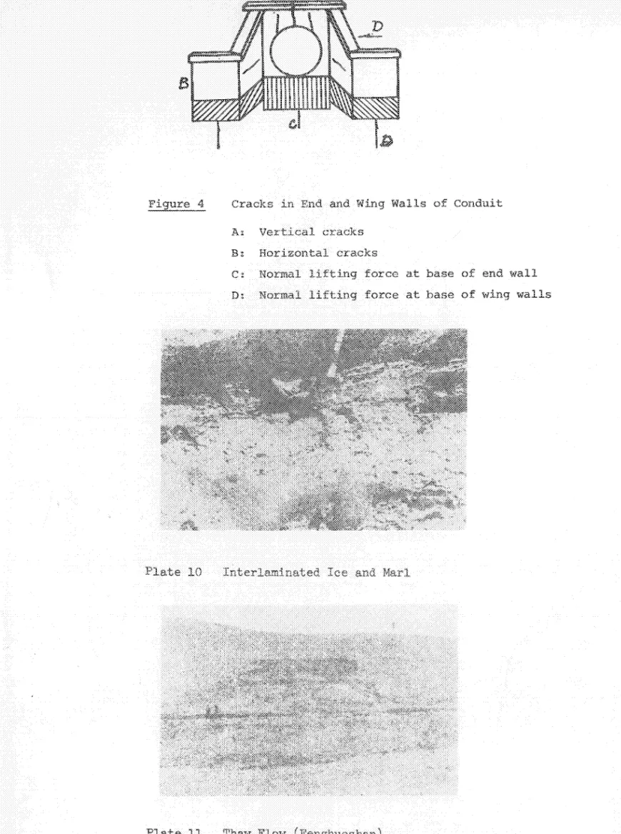
As for the construction of bridges and pipelines in perma-frost regions, it should be mentioned that wooden bridges are
quite susceptible to damage by frost heaving; in fact this can
be regarded as the primary type of frost damage to wooden bridges. Drainage pipes in these areas frequently become disjointed and
jagged, and the end and wing walls are pushed outward and are cracked as a result of the freezing and expanding of the
founda-tion soil. Figure 4 shows the cracks in the end and wing walls
·of a conduit in one of these areas.
II. Permafrost Phenomena Associated with Thawing
In regions characterized by clayey soil, which has a
relatively high water content, the upper portion of the perma-frost generally contains a thick layer of ice, either formed purely of ice or consisting of ice admixed with detritus and
lumps of soil. The thickness of this layer of ground ice
varies widely, from 20 or 30 cm to 4 - 5 m. The upper part of
this ice layer comes into contact with the seasonally thawed layer, while the lower part merges with the permafrost table. The ice generally is distributed either in a lens or in a layered form (Plate 10), and its extent is often suggested
by the overall surface relief. Because this sort of thick
ice layer is not far beneath the ground surface, it can
very easily melt under the influence of natural or artificial
factors. Melting of this ground ice can produce thaw flow*,
solifluction and thaw settlement** among other phenomena
characteristic of permafrost regions. These are all extremely
dangerous for engineering and construction works.
A. Thaw Flow
On the slope of Fenghuoshan, a mountain on the Tibetan plateau, workers once excavated dirt and left a single small
pit. In just a few months time this pit had changed into a
large furrow several dozen metres long. After three years
this furrow had grown even longer and wider, and had extended all the way to the mountain top, leaving the mountain "utterly
ragged and broken down", as the saying goes. The old proverb
"the hole of an ant can destroy a mighty dike" must indeed be
true. This kind of phenomenon is known as thaw flow. How is
it produced?
* Translator's note: Literally, "thaw-slip-collapse".
- 16
-After the excavation was finished, subsoil ice was left
exposed along the walls of the small pit. This ice melted when
the thawing season arrived, causing the upper soil and grass cover to lose its support and collapse under its own weight. This material fell down the slope (of the pit), covering the layer of ice which had lain exposed but at the same time newly
exposing the subsoil ice in the area just above the pit. The
cycle then repeated itself, producing a new collapse, new exposure and so on, extending upwards until a more general
collapse resulted (Plate 11). Since these thaw flow slides
occur step-by-step, a terraced type of surface is often left
behind. Moreover, the collapsing proceeds mainly from bottom
to top, with only slight lateral development, and this means that the debris strewn down the slope has a tongue- or winnow-shaped outline.
When a retrogressive thaw flow slide of this sort occurs on a slope having a relatively thick layer of ground ice, it may well be attributable to the effect of human activities
(e.g., engineering work or excavation of soil). Or it may be
the result of natural causes (e.g. fluvial erosion of the
slope). Muddy material from the thaw slide often will flow
down and cover the surface of a road, block culverts,
acceler-ate the softening and subsidence of a roadbed, etc. Thaw flow
thus frequently affects communications.
B. Solifluction
The structure of fine grained soil on gentle slopes is
destroyed by freezing and thawing action. As this type of
ground thaws, moreover, the water that is released is unable -to infiltrate downwards owing to the underlying layer of frozen
ground. As a consequence the surface soil on such slopes
becomes saturated and can turn to sludge, which, under the influence of gravity, will slide over the frozen layer and
work its way down the slope. This phenomenon is called
Two types of solifluction can be distinguished, one involving the surface layer and the other, deeper layers. Surface solifluction occurs in the upper portion of the
thawed layer. It is widely distributed, but occurs on a
comparatively small scale. Finally, this type of flow is
relatively fast. Deep-layer solifluction, meanwhile,
usually occurs on gentle slopes «100 ) which do not drain
well. A layer of underground ice or permafrost serves as
a slip plane. Flows of this type can be several hundred
metres long and several dozen metres wide, and they can
give the soil surface a staircase-like appearance. Flow
in these cases is slow and not easily observed.
The dangers posed by solifluction do not arise as
quickly as those associated with icings or pingos, nor are
they as serious. Although solifluction does not pose an
immediate threat, it can destroy buildings and other
con-struction works with the passage of time. For example,
solifluction on a mountain in one area, working slowly but irresistibly over a three-year period, pushed railroad tracks 18 m down the slope.
C. Thaw Settlement
The depth of seasonal thaw increases when the temper-ature of the surface soil is raised as a result of natural
(e.g. warm weather) or artificial (e.g. cutting trees,
burning wood to heat houses, etc.) factors. This downward
extension of thawing means that the ground ice or permafrost partially melts, causing the overlying soil to settle because
of its own weight or because of external loads. Such a
phenomenon is called thaw settlement.
Thaw settlement that occurs under natural conditions often will be manifested as a hollow, a lake basin bog, a staircase-like relief, etc.
18
-Human activities very often are the cause of thaw
settle-ment. In permafrost regions almost every construction project
railroads, roads, buildings, bridges, pipes, etc. - can give
rise to such settlement when proper countermeasures are not taken, and this negligence can lead to deformation or destruction of the
completed structures. Experience has shown that settlement caused
by melting of ground ice is a major threat to all types of con-struction works in permafrost areas.
A so-called thaw basin (Fig. 5) usually develops under
heated houses or other buildings. As the soil within this basin
thaws it will subside and be compressed, under its own weight as well as the weight of the building above, and this subsidence
frequently leaves the foundation uneven. When the unevenness
passes a certain point the building will be affected, eaves twisting every which way, doors and windows going askew, walls
being cracked, etc. In severe cases the building itself will
tilt and may eventually topple over and become totally unusable. In permafrost regions the main cause of damage to railway
roadbeds is thaw settlement. Three types of settlement can be
distinguished:
Compression Settlement
Mainly occurs in marchland or areas of tall grass where water accumulates.
Because tall grass, peat and so on are readily compressed, the weight of embankments and the vibrations and loads of pass-ing vehicular traffic will eventually make the soil more compact,
leading to subsidence of the roadbed. This subsidence may amount
to as much as 45 - 70% of the thickness of the entire peat layer
·This type of settlement often stabilizes during the construction period, or after a year or two of operation of the completed road, etc.
Gradual Settlement Over the Years
This type of settlement occurs in areas with underground ice.
Removal of the grass cover or peat layer during con-struction, or the accumulation of water on top of a completed road embankment and its subsequent infiltration downward, can cause ground ice to slowly but steadily thaw, and this in turn can cause the roadbed to gradually subside year by year.
For example, in one area water accumulating on an embankment
1.8 m high caused ground ice to melt, and this thawing led to an average annual decline of 500 - 600 rom in the embank-ment, the amount of subsidence reaching 1000 rom in rainy
years. Subsidence of this type makes road maintenance work
very troublesome.
Sudden Settlement
Sometimes roads are built over clayey, ice-rich soil. When this ice melts the soil reaches a supersaturated state,
and i t may almost entirely lose its bearing capacity. In
addition, when the depth of thaw is unequal on the two sides of the embankment, a slanting, frozen slip plane is
formed beneath the roadbed. Under these conditions the
vibrations and loads resulting from passing traffic may force the supersaturated clayey soil to be squeezed out along' the frozen slip plane, so that a sudden slump will occur in an embankment that had been gradually subsiding
during a warm period. Sudden settlement often will cause
vehicles to lose the road and have accidents.
In the Great Khingan Range subsidence of embankments is due in the majority of cases to melting of a thick layer
of ground ice. There can be no question that thaw
settle-ment is a major cause of damage to railroads in permafrost regions.
Generally the buttresses of bridges are buried fairly
deep; furthermore, they are cold structures. Settlement,
therefore, seldom affects the span of a bridge. However,
when piping is laid in the northeast, where ground ice abounds, the permafrost table may drop if the ground is
- 20
-excavated improperly. Melting of the ground ice can then cause
the pipes to subside. Because the foundations supporting the
ends of pipes are buried relatively deep, the ends will sink less
than the middle section. This results in pipes sagging in the
middle (Fig. 6) and leaking from the bottom.
Water pipes can become disjointed because of unequal
sub-sidence, or may even be cracked apart. Thus settlement can
damage them in much the same way as frost heaving. The difference
is that one occurs in regions characterized by ground ice and the other in areas with fine grained soil having a relatively large water content.
III. Commonly Observed Types of Frost Damage in Buildings
and Engineering Works
A. Water Entering Heated Buildings
Heated buildings maintain above zero (oC) temperatures
year-round so that some of the ground underneath them remains in
a thawed state year-round, too. This thawed ground is shaped
like a basin (Fig. 7). When groundwater is present in the soil
above the frozen layer, it is able to flow freely in the summer;
however, once winter comes, the ground surface all around the building freezes up, and this compresses and confines the water
in the soil. At this time only the ground beneath the building
is still in a thawed state and is relatively pervious. The
hydrostatic pressure of the groundwater increases as the frost extends downwards, and eventually the point arrives when the pressure exerted by the confined water exceeds the resistance of
the building's foundation soil. At this point water will burst
through the floor of the building and flood the rooms, leaving those in the building no choice but to dig a hole or pit indoors to hold the water, day and night scooping it up in pails or
buckets and taking it outdoors. In some cases as much as 48
buckets of water will need to be removed each day, and this is a great inconvenience.
セセ
I
I
B. Bar-Shaped Foundations and Inward Curving of Outer Walls of Buildings
In winter, when the ground surrounding a building freezes up, pressure will be exerted horizontally against the
build-ing's foundation soil, pushing it inwards. Since the soil
beneath the building will still be in a thawed state, its strength will be far less than the inward pressure of the
freezing and expanding soil surrounding it. As a result
the foundation soil will be pushed inwards from all sides when its strength is no longer sufficient to resist those
pressures. This type of deformation of the foundation
inevitably leads to concave bending of the outer walls of the building above.
C. Frost Boils
Frost boils can occur in seasonally frozen regions for
a variety of reasons. One major cause is the wintertime
accumulation of water in fine grained soil under roads
(i.e. the migration of water up toward the frozen surface).
This water turns to ice. During the winter the road surface,
freezing and expanding slightly, will frequently develop
cracks, but this in itself will not affect traffic. However,
when spring arrives and the roadbed begins to thaw, the accumulated ice also melts and, owing to the inferior drainage capacity of fine grained soil, the roadbed will reach a saturated or supersaturated condition and Its
bearing capacity will be sharply diminished. At this point
the weight from the repeated passing of vehicles will cause
the road surface to change. If light vehicles are on the
road the pavement will simply become soft, restricting the speed of traffic, but heavier vehicles will cause the soil beneath the road to be pushed out onto the surface,
cover-ing the road with mud. Vehicles can become mired in the
- 22
-Frost boils similar to the types described above can occur on roads in permafrost regions, too. They can be due to the
causes cited above or to other factors. Take, for instance, a
road passing through a region with abundant ground ice. If for
some reason the depth of thaw increases one year, the ground under the road may become saturated with water when the ice melts, and the repeated pressure exerted by traffic on the road can cause a deep frost boil to form.
IV. Stopping up of Drainage Pipes and Water Pipes
A drainage pipe often will become blocked with ice when it is conveying spring water from a slope above it, particularly if the flow is slight. Under these conditions the onset of
winter will mean that water which has not yet discharged from
the pipe will freeze inside it. This layer of ice will gradually
become thicker, eventually stopping up the drainage pipe.
More-over, since water expands in volume when it freezes, drainage pipes stopped up with ice are frequently cracked open.
The temperature of groundwater is very low in permafrost
regions. Water flowing through a water pipe in winter constantly
loses heat to the cold pipe wall. When the temperature of the
water falis below
aOc,
the pipe will become lined with ice. Ifthe ice on the pipe wall grows thicker it may obstruct the flow of water, eventually stopping up the water pipe altogether and possibly cracking it open. The result, of course, is an inter-ruption of water supply.
All of the various permafrost or frozen ground phenomena outlined above pose threats to engineering and construction
works, but, (as Chairman Mao has written), "Under certain
conditions, good results can be obtained from bad things, and
bad things can also be obtained" from good things." In their
struggles against all these kinds of frost セセイョ。ァ・ over many
years, the broad masses of workers, peasants and soldiers have gained considerable experience in turning these misfortunes to advantage.
For example, icings and pingos are indeed dangerous to
buildings and engineering works. Nevertheless, they can
serve as excellent indications of where supplies of water may be found in frozen ground regions characterized by a dearth of water sources. Pingos and icings are very easy to spot in winter, and below these i t is usually possible
to find groundwater. When warmer weather arrives frost
mounds and icings disappear, but their activities leave
behind traces of their presence. After a mound disappears,
for instance, a "druken forest" created by it does not
disappear. Sparsely spaced, dwarfishly small or even
withered plants can indicate that an area was covered with a sheet of ice; some icings, furthermore, leave white
mark-ings on the bark of trees, etc. All of these signs can be
put to use to help find water. Pingos, which do not disappear
even in warm weather, can serve as reliable indicators of
water sources. In March, 1958, an icing was discovered in a
certain area in the Great Khingan Range. Trees were found
caught in a layer of ice 3 - 4 m thick, and no vegetation at
all was growing in a belt 50 - 10C m wide and about 200 m
long. From this icing i t was discovered that spring water
was rising to the ground surface along a fissure. As much
as 650 tons of spring water per day was found to issue from
this crack, even in dry periods. This water was of a very
high quality, suitable for drinking or for industrial use. Also in the Great Khingan Range a pingo formed by artesian
water was discovered near a town. This mound was 90 cm
high and had water issuing from its fissured summit,
spurt-ing about 10 cm into the air. Investigation revealed that
over 400 tons of water per day issued from this source. This high-quality, soft water has already become a major supply source for this town.
In addition, the considerable strength of frozen ground
can be utilized to build roads on marshland. The low
セ 24
-refrigerators within the soil itself, and low-temperature
laboratories can also be built in this way. The
imperme-ability or poor permeimperme-ability of frozen ground can be used to construct darns or intercepting drains in the winter. The excellent bonding properties resulting from the freez-ing of groundwater can be utilized to establish wells in
areas of shifting sand. The strength produced by the
freezing of a building's foundation to underlying frozen ground can be utilized to support the weight of buildings;
building foundations, furthermore, can be placed right in
the permafrost layer itself and the strength produced by the freezing of a building's foundation to permafrost can be used to combat the effects of the heaving pressure
within the seasonally frozen layer. In short, there is
really no reason to fear permafrost. So long as we
thoroughly understand the laws governing its behaviour, we can control i t and prevent the damage i t would other-wise cause; and we can even turn i t to advantage.
CHAPTER TWO THE DISTRIBUTION AND FORMATION OF FROZEN GROUND
1. The Distribution of Frozen Ground in China
Before introducing the distribution of frozen ground in China, we will mention the two parameters that
deter-mine the distribution of frozen ground: the temperature
and the thickness of the frozen ground layer.
As we all know, the temperature of the atmosphere
within a year varies from month to month. Similarly, the
temperature of a frozen ground layer above a certain depth
also varies from month to month. We now define the yearly
ground temperature differential as half the range of change
of the ground temperature within a year. In Figure 8, Al
and A
2 represent the depth where the respective yearly
ground temperature differentials are Zl and Z2. The yearly
ground temperature differential is greatest in value at the ground surface, and decreases as the depth increases, until at a certain depth its value becomes zero.
The depth at which the annual ground temperature fluctuation is zero is termed the depth of zero annual
amplitude. (Depth h
2 where b is in the figure.) One can
safely say that the ground temperature below this depth
does not vary within the year. In the Greater Khingan
Mountain region, the depth of zero annual amplitude is usually between 15 and 20 m, while in the Chinghai-Tibet plateau it is usually between 10 and 15 m.
The value of the ground temperature at the depth of
zero annual amplitude is called the 。vセl。ァ・ annual ground
temperature; t • t is negative in the region of
ep ep
perennially frozen ground. The lower the value of t ,
- 26
-the greater -the thickness of -the perennially frozen ground,
and an increase of t e p indicates degradation of the perennially
frozen ground while a decrease indicates aggradation. The value
of tep is positive in non-permafrost regions.
In a permafrost region, there is a depth below the ground surface where the highest value of the ground temperature is
zero. (This is shown in the figure as depth h
l at point a.)
The ground above that depth thaws in the summer and freezes in
the winter, hence is a seasonally thawed layer. The ground
below that depth remains frozen all year round, hence is
perennially frozen. Therefore we term this depth as the bottom
of the seasonally thawed layer or the upper limit of the
peren-nially frozen ground. The depth h
l is then the thickness of
the seasonally thawed layer, or the depth of the upper limit of the perennially frozen ground.
The value of the ground temperature in the lower part of the permafrost layer is zero degrees (for example, at depth
h3 at point c). This depth is called the iョセセイ limit of the
perennially frozen ground, above which lS the permafrost and
below which is thawed ground.
The distance between the upper limit and the lower limit of the perennially frozen ground is its thickness (as H in the figure) .
In the permafrost region there may be areas without frozen
ground. The latter is called the thawed region and i t consists
of two types: one in which the thawed ground starts from the
ground surface and goes right through the whole frozen ground layer, this is called the thoroughly thawed region; and the other is thawed ground but does not penetrate the frozen layer, such that there is frozen ground below the thawed ground, this
is called the nonthoroughly thawed layer. Usually a thoroughly
nCqr hot springs and under big heated buildings, while
nonthoroughly thawed regions are セッイュ・、 under beds of
small rivers, some beaches along the rivers, and under ordinary sized heated buildings.
In China, perennially frozen ground is distributed in the northeastern part, north of the Greater Khingan
Mountain and north of the Lesser Khingan Mountain, in the Chinghai-Tibet Plateau, as well as in the western high mountains such as Tienshan, Altai Mountain region (see
Figure 9). The total area of permafrost in China is about
18.5 to 19 million square kilometres, about 19 to 20% of
her territory. The distribution of the perennially frozen
ground is governed by latitude horizontally, and by altitude vertically.
The highest latitude of permafrost in China is in the
northeastern region. Here the winter is 8 months long while
the summer is very short, with the presence of dense forests. All these contribute to advantageous conditions for the
existence of permafrost. From the northern part of this
region southwards, the distribution of permafrost changes
from continuous to island type distribution. In the very
northern part of the Greater Khingan Mountain, apart from the Ergune River, the Heilungkiang and the beds of their
branches, some of the river beaches, and the exposing
regions of hot springs (these are thawed regions), the
basic distribution of permafrost is continuous. Further
south we have the southeastern tip of the permafrost of the Europe-Asia Mainland, this is a transition region between perennially frozen ground and non-perennially frozen ground where the occurrences of permafrost are scattered among the thawed regions like islands; thus it
MMセMMMMMM⦅NセMMMMセMMMMMMMMMMMMセMMMMMMM MMMMMMMMMセセ]]]]]]]MBMLLᄋ⦅ᄋ]セセセセMMi
- 28
-of these permafrost areas are found under tatao* grass or the bog muck stratum in marsh land area, while a smaller number occur in the lowland moors in the furrow valleys not in the
direction of the sun. The latter type bears the
character-istics that their surface area is usually not too big, has high ground temF8ratures, small thickness and is usually
unstable. Further south we have the seasonally frozen layer
that has not gone completely through the thaw stage found in marsh land or bog muck developed regions or residual of the
regressed perennially frozen ground. This type of frozen
ground is usually buried more deeply below the earth surface and is not in contact with the seasonally frozen ground. Table I lists the thickness and temperature of permafrost in
some regions of northeastern China. It can be seen from
Table 1 that the thickness of the frozen ground decreases from the northern region to the southern region while the average annual ground temperature increases in the same direction.
In the mid-latitude areas of the world, apart from present day glaciers or the scattered permafrost islands
found at, the summits of high mountains where it is snowbound
all year round, there is generally no perennially frozen
ground of any significance. However, in the western part of
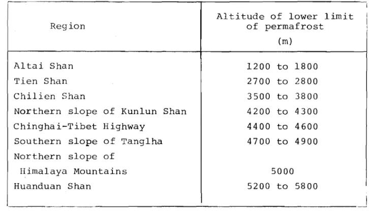
China, not only is there permafrost coexisting with glaciers and perennial snow accumulation (such as the perennially frozen ground at Tienshan, Chilien Shan, and Altai Shan), there are also large areas of continuous permafrost on the Chinghai-Tibet Plateau between the Himalaya Mountains and
Kunlun Mountains. Why are there large areas of perennially
* Translator's note: Phonetic translation only.
frozen ground at mid-latitude on the Chinghai-Tibet Plateau? This is because the general altitude of the Chinghai-Tibet Plateau is 4,000 m above sea level or more; hence the
temperature here is much lower than other mid-latitude
areas. The frozen period of the ground surface in this
region is as long as seven to eight months (from September
of each year to April or May of the following year). Even
in the warm season, there is temporary freezing of the
ground surface at night. An example is in the Kunlun
Mountains (approximately 4,700 m elevation), we have observed that even in the warmest month of July, the
highest temperature in the day is l7.6oC, while the lowest
temperature at night is only -SoC. Thus, apart from the
fact that there are thawed regions in the exposed zone of hot springs and beneath the large rivers, on the plateau the permafrost occurs in large areas and is continuous.
On the other hand, although Golmud is not quite 100 km
north of the Kunlun Mountains, since its altitude is only
2,800 m, there is no perennially frozen ground. It can
therefore be deduced that the existence of the permafrost on the plateau is governed mainly by the local altitude. Thus, the perennially frozen ground has a definite vertical distribution.
The lower limit of the distribution of permafrost can now be defined as the line that joins the altitudes where
the perennially frozen ground first appears. Table 2 lists
the values of the lower limit of permafrost in the western
part of China. It can be seen from Table 2 that, as the
latitude decreases, the lower limit of permafrost increases. This demonstrates that the distribution of permafrost on a
plateau, besides being governed by altitude, is also affected
by the latitude of its location. Corresponding to this is
30
-the average annual ground temperature decreases; hence -the
thickness of the permafrost increases (see Table 3). In the
Chinghai-Tibet Plateau, there is usually a decrease of lOC in the average annual ground temperature of the frozen layer as
the altitude increases by 100 to 150 m. A similar decrease of
lOC in the average annual ground temperature is observed as
one goes northward 100 to 200 km. The decrease in the average
annual ground temperature is accompanied by a corresponding increase in the thickness of the frozen ground.
The area of distribution of seasonally frozen ground far
exceeds that of perennially frozen ground. Of these the
region of distribution of the seasonally thawed layers is the
same as that of the perennially frozen ground. Apart from
being distributed in discontinuous permafrost areas and the thawed areas of permafrost regions, these seasonally frozen layers occur widely where there is no permafrost.
In the practical aspects of engineering, the depth of the foundations of buildings for industriRl 0r domestic
pur-poses is generally greater than 0.5 m. セィオウ basing ourselves
on practical engineering requirements, we have drawn isopleths
of thickness of 0.5 m for the seasonally frozen layer on the
diagram of the distribution of frozen ground. It may be seen
from this diagram that, in the temperature zone of China, the depth of the seasonally frozen layer is usually greater than
0.5
m.
2. The Formation of Perennially Frozen Ground
On the earth's surface there are complex processes of heat exchange, namely; radiation, convection and conduction.
The earth's surface absorbs the sun's セ_、ゥ。エゥッョ and at
the same time it continues to impart heat energy to the
atmosphere through radiation. The atmosphere, in turn,
imparts part of its absorbed heat energy back to the earth's surface through radiation.
Apart from exchange through radiation, there are also heat adjustments between the ground surface and the atmos-phere in the vertical direction via heat expended by
evaporation from the ground, the latent heat of condensation associated with the release of moisture from the atmosphere, as well as turbulent currents which exchange heat in the
vertical direction. Simultaneously there is a strong
exchange of heat in the horizontal direction through the atmospheric circulating currents and the ocean currents.
In addition to the above, there is also heat flow from the interior of the earth to the ground surface via the method of conduction.
Although the heat exchange processes at the ground surface are very complex, the net result is either heat absorption or heat loss at the ground surface.
During the cold half of the year, the ground surface
gives off heat so that the ground gradually cools. Generally
speaking, when the ground temperature decreases to below zero, the water in the ground freezes and the ground becomes
frozen ground. If, at that particular location, the amount
of heat absorbed by the ground surface within a year is greater than the amount of heat dissipated, then in the warm half of the year the frozen ground formed during the cold half of the year will thaw completely so that
season-ally frozen ground results. On the other hand, if at that
location the amount of heat absorbed in a year is less than the amount of heat dissipated, then the frozen ground formed during the cold half of the year will not thaw
com-pletely but leaves a residual part. If, over a long period
of time, the condition under which the yearly dissipated heat is greater than the amount of heat absorbed is
maintained, then, as the years go by, a permafrost layer of considerable thickness will be formed.
セセセMMMMMMMMM
--- 32
-Generally speaking, most of the permafrost is formed
after deposition and is frozen from the top downwards. This
type of frozen ground is termed epigenetic frozen ground. However, in the regions of accumulation, such as alluvial plains, developing deltas and diluvial fans, dried up lakes and marsh lands, occasionally one may find freezing in the deposition process, and hence the freezing of the permafrost
from lower regions upwards. This type of permafrost is
called syngenetic. Glacier ice buried in drift is the same
as syngenetic ice. In the middle of a solifluction area at
Fenghuo Shan on the Chinghai-Tibet Plateau, there was observed a rise in the permafrost table due to mud flows, resulting in an increase in the thickness of the frozen ground from the
lower part upwards. In the natural environment one often
observes a mixed frozen ground layer consisting of isogenetic
frozen layer and syngenetic frozen layer. An example of this
is that of the lower layer of the perennially frozen ground
being isogenetic while the upper layer is syngenetic. This
condition is called a multigenetic frozen layer.
Because there has been little research done on the for-mation of permafrost in China, at the present i t is still
difficult to determine its origin. However, based on the
existing information, it is possible to make a general analysis
on the origin of permafrost in China. Existing data indicate
that the thickest permafrost in China may reach 100 to 200 m. "Three feet of ice cannot be formed in just one cold day", as
a Chinese saying goes. It is therefore evident that such thick
frozen ground cannot be the product of one or several years; its formation must date back to many, many years ago.
It is known that there were several large scale glacier
movements during the Quaternary. During the glacial age the
climate was cold. Very thick layers of frozen ground were
formed at the edge of the land with glacial movement, provided there were suitable geological and geographical conditions.
It is now understood that there were glacier movements on the Chinghai-Tibet Plateau and in the Greater Khingan
Mountain in the Quaternary. Thus, very thick frozen ground
layers were already formed at that time. Starting from
roughly 17,000 years before now, earth's weather became
warmer and the glaciers withdrew. The time span from then
until the present is termed the postglacial period. The
change of the weather during the postglacial period is
shown in Figure 10. The figure illustrates that, about
five thousand years ago, there was a high temperature
period. During that period the frozen ground in the
Chinghai-Tibet Plateau and in the northeastern part of
China either partially or completely thawed. About 2,500
to 3,000 years ago, the weather again became cold and wet and continued for a period of about 2,000 years (The Little
Ice Age). At this time, the residual frozen ground from
the thawing at the high temperature period continued to thicken and is preserved to this day.
During the past one hundred years, there was a
tendency for the climate of the world to become warmer, thus causing some regression of the perennially frozen ground in
certain areas. One example is the southern boundary of the
perennially frozen ground in northeastern China. Due to the
warming of the climate, the ground ice melted under natural conditions, thus bringing about the creation of thaw lakes,
thaw settlements, etc. The southern boundary of permafrost
also moved northward; some of the permafrost at the southern boundary disappeared naturally over a period of several
years or decades. All this demonstrates that many
perma-frost areas in northeastern China degraded because of the change towards a warmer climate.
- 34
-We should be aware of the fact, however, that the peren-nially frozen ground is not the product of just one factor;
the climate. One example is in the Chinghai-Tibet Plateau;
there are numerous thaw basins related to the melting of the ground ice, while on the other hand, we see examples of the increase in thickness of the permafrost in mud flow
accumula-tions. Another example is in the northeastern part of China;
under identical climatic conditions, there is permafrost in some areas but not in others, or in some other instances
permafrost exists beside areas with no permafrost. All this
means that the existence of the permafrost is not caused by
only one factor. The climate is also related to other factors
such as geology and geography. Perennially frozen ground is
therefore a product of the combined factors of climate, geology and geography.
3. The Relationship between Frozen Ground and
the Local Conditions
There is a very close relationship between the dissipa-tion or absorpdissipa-tion of heat by the ground and the change in
weather .. Thus, the change in climate is a very important
factor governing the formation and development of frozen
ground. Moreover, the factors of radiation, aerial
circula-tion, geology and geography (latitude, altitude, distribution of land and water, ocean currents, landform, etc.), are
interrelated, one factor influencing the other and together they control the change in climate.
Radiation from the sun is the fundamental motive force
behind the change in climate. The aerial circulation accounts
for the difference of climate at various locations. The
geological and geographical factors, however, may modify the effects of the radiation factor and the forms of the aerial
circulation. Thus, the geological and geographical factors
The distribution of radiation energy from the sun is mainly determined by latitude, while the aerial circulation
is mainly caused by the difference of heat energy from the
sun at different latitudes. Thus, latitude is the most
important of the geological and geographical factors to
affect the climate. Thus, the climatic regions are drawn
according to latitude. The effect of altitude on climate
is even more pronounced than the effect of latitude; therefore in the high mountain regions one may sometimes observe a range of vegetations over a range of altitude, varying from dense, thick tropical forests at the bottom of the mountain to land covered with glaciers, without as much as a stalk of grass for its vegetation at the mountain
summit. However, the higher the altitude, the smaller the
ground surface area; this decreases the effect of altitude
on climate. The distribution of land and water also has a
very significant effect on the temperature differentials. It follows that besides the possibility of dividing the
globe into climatic regions, it is 。ャセオ possible to
subdivide each climatic region ゥョセッ continental climatic
regions and oceanic climatic regions.
The geological, geographical factors over a vast region (latitude, altitude, distribution of land and sea, etc.) are the important factors to influence the climate.
Regionally geological and geographical factors (medium
size landforms, large areas of vegetations, etc.) may, within the bounds of the same climatic region, produce
small climatic differences to form the so-called regional climate, while the regional geological and geographical factors (small landforms, characteristics of vegetations, special features of the land surface, and snow coverage, etc.) may influence the atmosphere from the ground surface to two metres above it, to form the so-called microclimate.
- 36
-Since the geological and geographical factors are important factors influencing the climate, and at the same time they also control the heat conduction process of the ground, it follows that they are important factors in
deter-mining the forma+ion and development of frozen ground. This
is why we say that frozen ground is the joint product of the climatic, geological and geographical factors.
We have already seen from the distribution of frozen ground in China that its distribution temperature and
thick-ness, mainly follow the rules of latitude and altitude. In
a region of fixed latitude and altitude, formation and type of frozen ground are determined by the regional geological and geographical conditions.
In the following sections the effect of geological and geographical conditions on the distribution of permafrost and its temperature and thickness are discussed.
A. Ground and Water
The effect of latitude and altitude may be combined as
the effect of temperature. Temperature is the external
con-dition for the formation of frozen ground, while the internal conditions for the formation of frozen ground are the nature
of the ground and its water content. In his article "On
contradiction", Chairman Mao discussed the metaphysical world
outlook, "They search in an over-simplied way outside a thing
for the causes of its development, and they deny the theory of materialist dialectics which holds that development arises
·from the contradictions inside a thing. Consequently they
can explain neither the qualitative diversity of things, nor the phenomenon of one quality changing into another."
•
*Thus if we want to discuss the existence of the thousands of facies of the frozen ground within the same region, we have first to study the internal causes, namely; ground and water .
Frozen ground differs from other types of ground in
that it is "frozen". This "frozen" condition is caused by
the freezing of the water within the ground. Thus the
freezing of the groundwater constitutes the special feature of the frozen ground, and this freezing has characteristics
different from the freezing of ordinary water. We have to
understand these characteristics before we can have the correct interpretation on the many complex facies of the
frozen ground. These characteristics are: the existence
of unfrozen water within the frozen ground, supercooling of the groundwater, the change of heat properties after freezing, and the movement of the water, etc.
(a) Unfrozen water
Although the ground is "frozen", there still exists some unfrozen water, which remains in a liquid state under conditions of negative temperature and certain
pressure. Why is the unfrozen water not frozen at
negative temperatures? The answer to the above question
is the effect of the interaction of ground and water at negative temperatures.
First, let us examine the structure and nature of a
water molecule. The chemical representation of a water
molecule is H20, meaning that it is made up of two
*Translator's note: All appropriate translations of the
quotations of Chairman Mao are taken from the "Selected works of Mao Tse-Tung", published by the Foreign Language Press, 1965.
- 38
-hydrogen atoms and one oxygen atom. The nuclei of these three
atoms make up an isosceles triangle, with an apex angle of 1050
(see Figure ll). The oxygen nucleus occupies the apex of this
triangle while the two hydrogen nuclei occupy the ends of the
base of the triangle. The electrons they carry (eight for the
oxygen nucleus and two each for the hydrogen atoms) are
rearranged in a new manner when the water molecule is formed, and each moves in its neighbourhood according to some fixed
rules. Since the oxygen nucleus differs from the hydrogen
nuclei, in particular the number of electrical charges carried
by the nuclei is different, it follows that the interactions
between the electrons and various nuclei are different. The
net result is that the electron has a much higher probability of spending its time closer to the oxygen nucleus than to
a hydrogen nucleus. Thus, the distribution of an electron in
a water molecule does not follow an even pattern, but spends more time at the oxygen end of the molecule and less time at
the hydrogen end of the molecule. Although the electrical
charge of the water molecule as a whole is neutral, the oxygen end of the molecule appears negatively charged while the
hydrogen end of the molecule appears positively charged. This
type of molecule with positive charge at one end of the molecule and negative charge at the other end of the molecule is called a dipolar molecule.
Let us now examine the ground particles. The surface of
the ground particles are made up of free radicals or ions. These free radicals or ions bear electrostatic attracting forces; thus, an electrostatic attracting force field is
formed in the region of the ground particle surface. The
water molecule, being a dipolar body, is therefore attracted
by the electrostatic attracting force. Thus, when water is
in contact with the ground particle, it will interact with