HAL Id: hal-02553833
https://hal.archives-ouvertes.fr/hal-02553833
Submitted on 24 Apr 2020HAL is a multi-disciplinary open access archive for the deposit and dissemination of sci-entific research documents, whether they are pub-lished or not. The documents may come from teaching and research institutions in France or abroad, or from public or private research centers.
L’archive ouverte pluridisciplinaire HAL, est destinée au dépôt et à la diffusion de documents scientifiques de niveau recherche, publiés ou non, émanant des établissements d’enseignement et de recherche français ou étrangers, des laboratoires publics ou privés.
Reliability of virtual reality for user experience in
spatial cognition: an exploratory approach
Anaëlle Hily, Christel Jacob, Laurent Dupont, Giovanny Arbelaez, Jérôme
Dinet, Mauricio Camargo
To cite this version:
Anaëlle Hily, Christel Jacob, Laurent Dupont, Giovanny Arbelaez, Jérôme Dinet, et al.. Reliability of virtual reality for user experience in spatial cognition: an exploratory approach. ConVRgence (VRIC) Virtual Reality International Conference 2020, Laval Virtual, Apr 2020, Laval, France. pp.68-80. �hal-02553833�
1
Reliability of virtual reality for user experience in
spatial cognition: an exploratory approach.
Anaëlle Hily
1,2,3, Christel Jacob
2,4, Laurent Dupont
1, Giovanny Arbelaez
1, Jérôme
Dinet
2, Mauricio Camargo
1.
1 Université de Lorraine, ERPI, EA 3767, F-54000 Nancy, France 2 Université de Lorraine, 2LPN, EA 7489, F-54000 Nancy, France 3 TEA (Tech Ergo Appliquées), F-54500 Vandœuvre-lès-Nancy, France
4 Centre Hospitalier Régional Universitaire, CMRR, F-54511 Vandœuvre-lès-Nancy, France
Corresponding author: Anaëlle Hily, [email protected]
Keywords: Virtual simulation – Spatial cognition – User eXperience – Protocol design – Physiological measurements
Abstract
Immersive virtual reality technologies have proven multiple experimental benefits for the study of spatial cognition in large-scale environments, such as a high control over variables and safe travels. However, in navigation tasks, the user orients himself thanks to an integrated, unconscious and complex mechanism combining the use of locomotion and cognition. The constraints linked to the use of a motor interface and a virtual environment for navigation raise questions about the possible generalization of the data collected in these digital experiments. Our long-term objective is to evaluate the reliability of virtual reality to assess the user experience in the specific dimension of spatial cognition. However, user experience in virtual reality is complex to evaluate, and navigation tasks are often evaluated with isolated subjective data.
In this paper, we describe the design of a comparative study dedicated to spatial cognition and involving a multidisciplinary approach (neurosciences, psychology, and engineering). We present the development of a protocol suited for virtual and real environments, combining the collection of subjective and objective data (behavioral, biomechanical and physiological measurements), then the modelling of a virtual environment dedicated to spatial cognition is described. To finish, the constraints met during an experimental test and the feedback of the participants are presented.
1. INTRODUCTION
Immersive virtual reality technologies is a very dynamic field, where innovation follows a very high pace of renewal (Anthes, García Hernandez, Wiedemann, & Kranzlmüller, 2016). One of the areas where the development of new immersive virtual technologies has given new impetus is the study of spatial cognition in large-scale environments, including navigation. Navigation combines both a locomotor dimension, i.e. a coordinated movement in the surrounding environment, and a cognitive component (including orientation, planning and decision-making, necessary to reach a destination) (Montello, 2005). Its study in Virtual Environments (VE) allows different experimental benefits, such as a high control over variables, safe travels and the possibility to access various environments. However, the design of these experimental materials is complex and rely on the good understanding of the human’s cognitive behavior in order to create an adapted model and interface. Moreover, questions remain about the user experience in these virtual experiences, notably about the possible generalization of these results in the real environment, also known as the ecological
Draft's Authors
ref: Anaëlle Hily, Chritel Jacob, Laurent Dupont, Giovanny Arbelaez Garces, Jérôme Dinet, Mauricio Camargo. Reliability of virtual reality for user experience in spatial cognition: an exploratory approach. ConVRgence (VRIC) Virtual Reality International Conference, Laval Virtual, Apr 2020, Laval, France. pp.68-80, <DOI: 10.20870/IJVR.2020..3316>
or external validity: does the simulation of a displacement in a VE have a similar impact on spatial cognition as the one caused by a displacement in a real environment?
The evaluation of the user experience can be done by collecting subjective and objective data (cognitive, behavioral, biomechanical and physiological). Most studies have used isolated data. Our goal is to combine these methods in order to make a more in-depth evaluation of the user experience, in order to assess the reliability of virtual environments in the field of spatial cognition. However, this methodology is a real challenge, which requires a multidisciplinary approach. Indeed, we believe that studying the issues raised by immersive technologies development with the expertise of both neuroscience and engineering fields could lead to a better understanding of the user experience and a more efficient and adapted design of virtual reality technologies.
In this paper, we present the design of a comparative and descriptive cross-sectional study, including the development of a protocol suited for virtual and real environments, and the modelling of a virtual environment dedicated to spatial cognition. We also present the first conclusions of an experimental pre-test, realized to identify possible technical constraints, and the future works considered.
2. RELATED WORKS
This section will focus on describing the main methods for evaluating the user experience in the context of navigation, adapted to both the real and virtual environment.
The evaluation of the user experience can be done by collecting subjective data, most of the time by using self-report questionnaires. This type of questionnaire can be useful to get specific information on the user after the experiment to understand how the person felt while performing, or before the experiment, such as a competency self-evaluation. One of the first scale is the "Santa Barbara Sense-of-Direction Scale” (Hegarty, Richardson, Montello, Lovelace, & Subbiah, 2002). Validity studies have shown that this scale is correlated with tasks evaluating navigation, based on a spatial strategy. "The Familiarity and Spatial Cognitive Style Scale" (Piccardi, Risetti, & Nori, 2011) takes into account the spatial cognitive style (route type or spatial type) and familiarity with the environment, internal factors that would influence the sense of direction. The “Wayfinding Questionnaire” (van der Ham, Kant, Postma, & Visser-Meily, 2013a) has the advantage of integrating 3 dimensions (with its own score) concerning spatial navigation capacities, distance estimation and a psychological measure of spatial anxiety.
To be independent from the user’s subjective interpretation and evaluate his behavior objectively, it is also possible to use physiological sensors, to measure muscle activity, heart rate or electrodermal activity for example (Kroes, Dunsmoor, Mackey, McClay, & Phelps, 2017; Meehan, Razzaque, Insko, Whitton, & Brooks, 2005). The use of objective indicators is essential to study phenomena that are not always conscious, as is the case in spatial cognition. However, the use of sensors also adds constraints to the experimentation field, because of their implementation, the possible discomfort they can cause to the participant, and the difficulty there may be in interpreting the data. Navigation based experiments are particularly demanding because the device must not be too invasive as to not distract or hinder the user’s gestures, and it should provide the clearest possible measure despite the risk of artefacts linked to the movements.
Biomechanical measurements such as eye tracker are also widely used in the field of navigation, and particularly in wayfinding tasks. Wayfinding refers to the ability to go to a given destination, in a new or complex environment. It is similar to a spatial problem-solving task and strongly mobilizes information search strategies in order to be able to plan and then execute the route. Although all of the senses can be mobilized, sighted individuals are essentially based on visual cues. The selection of visual cues in the environment, or selective attention, can be guided endogenously (involving a top-down process) or exogenously (bottom-up process). Studying the visual sense has several advantages, because it collects spatial information at a much
greater distance and at a higher resolution than the other senses, and because humans actively direct their visual sense (unlike, for example, the vestibular sense or hearing) (Kiefer, Giannopulos, Raubal, & Duchowski, 2017). In addition, the use of eyetracker is a particularly interesting tool for studying the strategies used to select this information.
Cognitive measurements are used to assess spatial memory. Tasks are generally distinguished according to the type of spatial knowledge they assess: the most basic, landmarks knowledge, can be evaluated via a task of recognizing or evoking landmarks present in the environment. Route knowledge is classically evaluated by a task of route-learning, where the subject must reproduce a route, learned either by direct navigation in the environment, or via a medium such as a map or a GPS, or even by a task of classifying the landmarks in chronological order of the route. Finally, survey knowledge, the most elaborate, is based on a cognitive map type representation, comprising the metric relationships between the landmarks, in a coordinate space. This knowledge is assessed by tasks such as locating landmarks on an environmental map, by map drawing, by pointing tasks, or even by estimating distance.
Distance perception is a much-debated topic in literature. In a real environment, the different mechanisms involved in an accurate distance perception are not yet fully understood, which of course complicates the design of an ecologically valid virtual environment. Indeed, egocentric distances tend to be underestimated to 74% of the modeled distances in virtual environment (Renner, Velichkovsky, & Helmert, 2013). In a review of the literature, Montello (1997) suggested that knowledge of the route distance can be based on three sources of information: the number of environmental landmarks, the duration of the route and the effort produced by displacement. Van Asselen, Fritschy, & Postma (2006) suggested that effort can be divided into physical and cognitive efforts, i.e. the requirement in terms of attentional and memory resources. Distance estimation is also influenced by the learning mode of the route (incident versus intentional). Thus, these authors (van Asselen et al., 2006) showed that participants who intentionally learned the route overestimated the walking distance, while the incident group underestimated it, suggesting that acquiring knowledge of the survey is effortful. These factors are thus to be taken into consideration for comparative studies of navigation in real and virtual environment.
Depth perception is known to rely on pictorial and nonpictorial cues. Pictorial cues are found on a static scene, where we use information of relative position to estimate the distance between an object and us. For example, if an object hides another then we will assume it is closer to us. If two similar objects are different in size, we will assume the biggest one is the closest, etc… (Cutting & Vishton, 1995) Consequently, increasing the number of nonpictorial cue and creating a well-furnished, complex virtual environment has shown positive impact (Kenyon, Sandin, Smith, Pawlicki, & Defanti, 2007). A common and homogeneous ground surface has also been identified as a key element to improve distance perception, the texture-gradient information being used as a depth cue (He, Wu, Ooi, Yarbrough, & Wu, 2004; Wu, Ooi, & He, 2004). Nonpictorial cues rely on the oculomotor system of the individual and its adaptation to motion. It includes for example convergence and accommodation, but also binocular disparity, which led to the development of stereoscopic presentation of virtual environments.
The study of navigation requires interaction with the VE, allowing or giving the illusion to the individual to move. However, its realistic implementation is also one of the most difficult tasks in the development of virtual reality (Steinicke, Visell, Campos, & Lécuyer, 2013). The best locomotion interface highlighted in literature involve translational and rotational body-based information, meaning the user needs the proprioceptive information generated while walking and turning or looking around, just as in a natural displacement. The use of an omnidirectional treadmill to address the need for natural walking in large-scale environment is also becoming more widespread (Ruddle, Volkova, & Bülthoff, 2011).
Regarding the VE itself, visual realism has been shown to improve spatial cognition (Meijer, Geudeke, & van den Broek, 2009).
Evaluating the user experience in a global manner thus pushes us to take into account a set of factors, at the same time physiological, psychological, cognitive and biomechanical, in order to be able to evaluate the
validity of a virtual environment in the study of spatial cognition. The previous review shows that given the complexity and diversity of the parameters to be taken into account, comprehensive methodologies need to be further developed. As a consequence, the objective of this exploratory research is to develop an experimental protocol aimed at assessing the impact of the environment media (real situation versus virtual one) on navigation performance, the navigation strategies to reach a determined destination, the spatial memory of the environment, the emotions (physiological reaction to surprising events), and the gap between subjective and objective evaluation.
3. METHODOLOGY
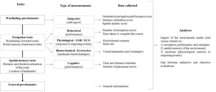
Our protocol proposes the combination of different tasks and type of measurements explored in the previous overview (figure 1).
Figure 1: Experimental protocol summary
GSR = galvanic skin response; ECG = electrocardiogram
3.1.
Tasks and Procedure
The navigation task was designed covering a path on two floors of the building of two French engineering schools. A similar environment was developed in virtual reality, which we will detail later. The protocol described below is designed in order to compare directly spatial cognition between the real and virtual setting without any knowledge transfer.
3.1.1. Subjective assessment: Wayfinding Questionnaire
First, participants were asked to fill a spatial orientation questionnaire (van der Ham, Kant, Postma, & Visser-Meily, 2013) before the beginning of the navigation task. This questionnaire evaluates navigation capacity, distance estimation and spatial anxiety. Results will be used in order to apprehend the gap between the objective and subjective data collected, and possibly anticipate it.
3.1.2. Navigation tasks: wayfinding and route learning
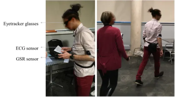
After answering the questionnaire and equipping the different sensors (see figure 2), participants were informed of the instructions: to go from the ground floor of the school to the underground parking lot of the school and bring back directly a lost set of keys located at a numbered parking space. The first part of the travel
is a wayfinding task, requiring the user to search for navigational aids in the environment such as signs, and make multiple decisions. The second part, on the way back from picking up the keys, focuses on the evaluation of spatial memory (backward route).
Figure 2: Sensor equipment
On the left, participant equipped with the three sensors (ECG sensor is worn under clothing directly on the skin). On the right, the participant moves with the bag containing the receiver case behind his back, an experimenter follows him during the navigation task. ECG = Electrocardiogram; GSR = Galvanic skin response
3.1.3. Spatial memory tasks
The participants were asked to estimate the duration of their travel and the distance they covered. Then, they had to reposition encountered landmarks of the ground floor on a map.
3.1.4. General questionnaire
Demographic information was collected such as age, sex, number of years of study.
3.2.
Measures
We collected both objective and subjective data. 3.2.1. Subjective (self-report navigation skills)
In order to assess the subjective skills of spatial navigation and distance estimation, as well as spatial anxiety, the participants completed the Wayfinding Questionnaire (van der Ham, Kant, Postma, & Visser-Meily, 2013). This scale has 22 items to rate on a Lickert scale from 1 to 7, giving a total score for each of the 3 dimensions assessed.
3.2.2. Behavioral (navigation performances)
To evaluate the navigation performances, we chose to analyze the number of orientation errors and the time taken to complete the route during the wayfinding task (forward) and the route learning (backward). 3.2.3. Physiological (GSR / ECG)
To measure emotional reactions we chose to collect physiological data using an electrocardiogram and a Galvanic skin response sensor.
The study of heart rate and its variability is used as an indicator of psychological stress. The heart rate variability is dependent on the autonomic nervous system and activation of the parasympathetic of sympathetic system. The last one is responsible for the stress-related physiological response by preparing the body to respond with action, thereby causing an increase in heart rate and a decrease in the heart rate variability. Physical and cognitive activity can naturally affect heart rate (Fallahi, Motamedzade, Heidarimoghadam, Soltanian, & Miyake, 2016). In this experiment, the participant is required to move around and use stairs to change floor, which can cause unwanted artefact of physical exercise. Therefore, we decided to consider heart rate only for the first part of the experiment, where the participant go from the ground floor of the school to the parking lot. The physical exercise being limited to walking and going down the stairs (Appelhans & Luecken, 2006; Azam, Ritvo, Fashler, & Katz, 2018; Kim, Cheon, Bai, Hwan Lee, & Koo, 2018; Rieger, Stoll, Kreuzfeld, Behrens, & Weippert, 2014).
The electrodermal activity, or galvanic skin response, is also used to measure an individual’s physiological response. In the literature a link is often made with the individual’s emotional state (Armougum, Orriols, Gaston-Bellegarde, Marle, & Piolino, 2019; Nourbakhsh, Wang, Chen, & Calvo, 2012). The electrodermal activity is based on the skin conductance variations, which are caused by the activation of sweat glands located on the palmar or plantar surfaces (Sequeira, Hot, Silvert, & Delplanque, 2009). As it is a direct reflection of the sympathetic system activity, this response can be the result of various causes (physical stress, emotional state, mental load, etc.) It is therefore difficult to associate this measure with a specific psychological or emotional state (Dawson, Schell, & Filion, 2000). In our protocol, we use the electrodermal activity sensor in order to evaluate the physiological reaction of the individual confronted to specific visual or auditory events, in the real situation and the modeling. Within the framework of a virtual environment, many parameters are controlled, which limits interpretation biases.
Moreover, concerning both the analysis of the ECG and GSR measurements, we are interested in observing the physiological reaction to a very precise and timed event. Therefore, we are looking for a sudden variation following the trigger of said event, and not the general evolution of a mean, which limits the risk of interpretive bias due to artifacts or uncontrolled parameters.
3.2.4. Biomechanical (landmark-based strategies)
In order to apprehend the navigation strategies of the individual an oculometric measurement is carried out with eyetracker glasses to identify the various landmarks used by the participant during the navigation task in the building. The objective is to compare the observation and landmark finding patterns in both real and virtual situations.
The same data will be collected in the real environment and its digital equivalent. We used T-sens sensors to collect the electrodermal activity and the heart rate. People navigating in the real environment wore Pupil Labs eyetracker glasses, whereas participants exploring the virtual environment wore a HTC Vive Pro EYE head mounted display (HMD) equipped with a built-in eyetracker system.
3.2.5. Cognitive (spatial memory)
We asked the participants to estimate the duration of their travel and the distance they covered. Then, they had to reposition encountered landmarks of the ground floor on a map.
The survey knowledge or the "cognitive map" is assessed through two tasks: an assessment of the distance of the backward route, (in meters), i.e. between the moment the subject takes the keys to the starting point and an estimate of its duration (in seconds). This distance was compared to the actual distance and duration.
To assess whether the subjective assessment of distance estimate was predictive of actual performance, the score of the questionnaire was compared to the objective estimate of the actual distance of the route.
Finally, the subject is asked, from a map, to replace 7 landmarks present in the hall in the right place. A score out of 7 was calculated.
4. IMMERSIVE ENVIRONMENT DESIGN
To investigate these questions, we designed a VE similar to one of the building of the engineering school used as experimental field (figure 3). To focus on the key elements essential to navigation and spatial perception, we used the design method developed by P. Fuchs, G. Moreau and J-M. Burkhardt (2006) (Richir, Fuchs, Lourdeaux, Millet, Buche & Querrec, 2015). They distinguish three levels of immersion and interaction: the functional, cognitive, and sensorimotor levels. The functional level states what we will ask the user to do in the future environment. The cognitive level clarifies the behavior schemes the user will have to use in order to realize these tasks. Finally, the sensorimotor level specifies the interface and technological devices needed.
4.1. Functional level
The design should allow users to travel and orient themselves naturally. It should display the underground parking lot and the ground floor of the school in a realistic manner and show the same visual landmarks, in order for the user to be able to create a mental map of the environment while navigating. The user should be able to read the different indicative signs to find his way and reach the given objective. Interactions should also be possible with elements hindering exploration, such as doors to open. The design should allow the user to assist to different surprising events and react to it.
This suggest:
• The possibility to travel in all direction of the immersive environment: change direction, retrace one’s steps, or take the stairs to another floor.
• To have a global vision of the environment: being able to read close signs or see landmarks from afar. • To watch an event and associate the sound with the visual effect.
• To manipulate door handles in rotation to open a door or to push it open.
4.2. Cognitive level
To answer the different tasks asked from the user in the previous level, he will have to use behavioral schemes linked to:
• Movement and navigation in a space • Global observation of an environment
• Sound and visual observation toward a determined direction • Gripping and spatial handling of a handle or a door.
To design our environment we used Unity game engine, which already parameters the physics between the objects of an environment (pictorial cues) and the sound localization, important for noticing and observing an event which takes place at a specific location. Several items (cars, chairs, coffee machine, plants…) were placed in the environment in order to display a rich cues environment, and particular attention has been paid to the different textures. They were developed using the software Blender to look as close as possible to the real surfaces of the building.
We did not make any changes to modify the parameters influencing the nonpictorial cues. They are linked to the hardware used, which will be specified later in this paper.
4.3. Sensory-motor level
The major point in the design of the interface is how the user will move in the environment.
In our case, the VE is too big to consider a free walk (it would require a very large empty hall, which we do not have) and the need to use stairs to change floor was a constraint. The use of an omnidirectional treadmill was not an option since we do not have this kind of technology in the laboratory yet.
To keep part of the proprioceptive information we chose to let the user rotate freely in the environment in order to change direction or look around. This was made possible thanks to the HMD built-in tracking system. For this pilot study, translational movements were controlled via the controller’s joystick. To use the stairs and change floor we chose to teleport the user as he approaches the steps. We know that setups with a linear speed of translation can cause a feeling of dizziness, therefore we were extremely cautious towards the participants during the experiment (McCauley & Sharkey, 1992).
The interactions with objects of the environment are performed with the controller. The user has to reach for the object and trigger a button to cause the action.
In our final environment, the user needs to manage a motor interface to move in the virtual building and interact with different objects. Learning how to use the controller and interact with the environment can take time and might complicate the beginning of the experiment, notably for users who are not familiar with the use of immersive virtual reality technologies. In order to lower the attention needed to use the interface and limit a possible additional cognitive load, we designed a learning phase involving a simple environment, displayed just before entering the main environment of the school building. In this first contact with the virtual world, the user can become familiar with each interaction necessary later in the experiment: how to open doors, to pick up an object, how to navigate in the environment and how to teleport up or down the stairs. The next step of the experiment is only started when the participant feels ready.
Concerning the hardware dedicated to the display of the VE, each participant will wear a Vive Pro Eye head mounted display with a Dual OLED 3.5” diagonal screen and a resolution of 1440x1600 pixels per eye (2880x1600 pixels combined). This device offers a field of view of 110° and a refresh rate of 90Hz. It is also equipped with an audio headset. The environment is rendered on an Intel Core i7-7700HQ processor computer, with a GeForce GTX 1070 graphics card and 16Gbytes of RAM.
Figure 3: real environment and its modeling
The ground floor of the school (a) and the underground parking lot (b), with the real environment on the left and the modeling on the right. On the left the eyetracker measure is pictured with a green circle (the green mark is also present in the VE but less visible)
5. PRELIMINARY RESULTS
A real condition experimental test was realized in order to identify the possible technical constraints and identify areas for improvement of user experience assessment in a mixed approach comparing reality and VE. We proposed this study to a group of 21 participants (10 females; 11 males; mean age: 24.3, min18-max31). After giving their written consent, they were assigned in two groups: the real environment (RE) group, or the virtual environment (VE) group. In the RE group the user wore eyetracker glasses, which was not compatible with the wear of corrective glasses. Therefore, all participants wearing corrective glasses were automatically included in the VE group. Those wearing corrective lenses or without correction were randomly assigned. 13 participants were included in the RE group and 8 in the VE group. It took eight hours to perform these experiments with 2 researchers and 1 engineer to accompany the passage of the participants for each situation VE and RE.
First results revealed frequent data loss in RE group, on both the ECG and the eyetracker measurements. During the experiment, the receiver of the ECG and the one used to record the oculometric data were placed on different location depending on the participants, in order for them to feel comfortable with the sensors and the cables. Our hypothesis concerning the ECG loss is that when the receiver was placed in a back pocket, the body caused too big an obstacle to collect the signal of the ECG sensor, placed on the chest. Considering the eyetracker issues, the fact that the participants were dynamic and walking during the experiment caused the cable to disconnect multiple times. In order to resolve these issues, the ECG receiver was upgraded and we plan to equip future participants with an adapted bag to place the receivers at the same location during the experiment, to favor an ergonomic setup and a better signal reception. A 3D printed part is being designed to secure the eyetracker cable to the socket. Future tests will validate the implementation of these solutions.
During the feedback sessions, participants expressed a discomfort concerning the sensors they wore. At the beginning of the experiment, while equipping the sensors, the experimenter notified them not to touch them or move them once they were in place. Participants told us that this instruction led them to be very focused on this particular point during the experiment and worried about doing something wrong. It may have impeded their movements and distracted them.
Considering the VE group, no technical constraints linked to the ECG, GSR or eyetracker acquisition were met. We observed that participants sometimes had difficulties to navigate in the environment. However, everyone agreed that the learning task in which one could try the interface and test the different interactions was enough to feel prepared for the navigating task. Those who may have felt difficulties perceived the virtual experience as anxiety inducing, and said that they felt pressured by the modelling because everything felt too close to them. We assume that this could be linked to a poor understanding of how the controller works. Some participants had issues pressing the button correctly in order to move in the environment, which may lead to a feeling of not being in control of the distance between them and the environment. This might be resolved by training the participants on the controller prior to wearing the HMD, so that they can properly see the controller while using it before beginning the learning phase.
On the opposite, certain participants reported that they felt the virtual environment was very safe because they knew nothing could happen to them. All participants agreed that the sound environment felt too empty and that moving with the joystick resulted in a feeling of dizziness. These feedbacks will be used to improve the virtual environment for future use.
6. CONCLUSION AND FUTURE WORKS
In this paper, we present the design of an original experimental protocol, based on the combined collection and analysis of subjective and objective data (behavioral, biomechanical and physiological measurements), to
evaluate the reliability of virtual reality to perform experiments involving spatial cognition of potential users. We also present the design of the VE and the results of a first experimental test involving students.
First results showed technical constraints due to the movement of the participants during this navigation task, and improvements have been identified for the VE. We plan to improve the sensor robustness and ergonomics, and implement the modelling according to the feedback of the participants in order to plan a second measurement campaign on a larger scale under better conditions.
The use of a joystick to control the translation in the environment is an important limitation of this pilot study. In future works we would like to explore the possibilities of the redirected walking technique, which seems promising to answer the physical constraints we met in the design of this protocol (Langbehn, Lubos, & Steinicke, 2018; Langbehn & Steinicke, 2018).
This study shows further comparison between RE and VE is improved by a multidisciplinary approach to user experience. The use of physiological data is reliable to have an objective evaluation of the user’s behavior and its interpretation should help determine for what kind of application we can use VE effectively. The understanding of complex cognitive mechanism such as spatial cognition requires a holistic approach in the type of data collected during the experimentation and the underlying technological means, as well as in the expertise of the analyses. In this new exploratory approach, research team involved psychologists, neuroscientists, 3D designer, technicians, etc. Substantial material and human resources were required for results that need to be strengthened before a real implementation. If the results of a larger scale experiment prove to be relevant, a future development path could focus on optimizing the cost effectiveness of such a process.
7. Acknowledgments
This study benefits from InnCognitif interdisciplinary Université de Lorraine program, N-HUM-INNO LabCom project (ANR) led by ERPI and the company TEA, and LF2L platform resources in particular its technical manager, Benjamin Ennesser-Serville, and the space supported by Métropole Grand Nancy. Authors thank Julien Michaux who designed the virtual 3D version of the building; Mary Laure Maxence from TEA; the technical staff of ENSGSI; EEIGM & ENSGSI’s general secretaries for access to buildings; IUVTT M2 students as participants.
8. References
Anthes, C., García Hernandez, R., Wiedemann, M., & Kranzlmüller, D. (2016, March 5). State of the Art of
Virtual Reality Technologies. https://doi.org/10.1109/AERO.2016.7500674
Appelhans, B., & Luecken, L. (2006). Heart Rate Variability as an Index of Regulated Emotional Responding. Review of General Psychology, 10, 229–240. https://doi.org/10.1037/1089-2680.10.3.229
Armougum, A., Orriols, E., Gaston-Bellegarde, A., Marle, C. J.-L., & Piolino, P. (2019). Virtual reality: A new method to investigate cognitive load during navigation. Journal of Environmental Psychology,
65, 101338. https://doi.org/10.1016/j.jenvp.2019.101338
Azam, M. A., Ritvo, P., Fashler, S. R., & Katz, J. (2018). Stressing the feedback: Attention and cardiac vagal tone during a cognitive stress task. Cognition and Emotion, 32(4), 867–875.
https://doi.org/10.1080/02699931.2017.1346500
Cutting, J. E., & Vishton, P. M. (1995). Chapter 3 - Perceiving Layout and Knowing Distances: The Integration, Relative Potency, and Contextual Use of Different Information about Depth*. In W. Epstein & S. Rogers (Eds.), Perception of Space and Motion (pp. 69–117).
https://doi.org/10.1016/B978-012240530-3/50005-5
Dawson, M., Schell, A., & Filion, D. (2000, January 1). The electrodermal system. Presented at the Handbook of Psychophysiology. https://doi.org/10.1017/CBO9780511546396.007
Fallahi, M., Motamedzade, M., Heidarimoghadam, R., Soltanian, A. R., & Miyake, S. (2016). Effects of mental workload on physiological and subjective responses during traffic density monitoring: A field study. Applied Ergonomics, 52, 95–103. https://doi.org/10.1016/j.apergo.2015.07.009
Fuchs, P., Moreau, G., & Burkhardt, J.-M. (2006). Le traité de la réalité virtuelle Volume 2 - L’interfaçage:
L’immersion et l’interaction en environnement virtuel. Retrieved from
https://hal-mines-paristech.archives-ouvertes.fr/hal-00753814
He, Z. J., Wu, B., Ooi, T. L., Yarbrough, G., & Wu, J. (2004). Judging Egocentric Distance on the Ground: Occlusion and Surface Integration. Perception, 33(7), 789–806. https://doi.org/10.1068/p5256a Hegarty, M., Richardson, A. E., Montello, D. R., Lovelace, K., & Subbiah, I. (2002). Development of a
self-report measure of environmental spatial ability. Intelligence, 30(5), 425–447. https://doi.org/10.1016/S0160-2896(02)00116-2
Kenyon, R. V., Sandin, D., Smith, R. C., Pawlicki, R., & Defanti, T. (2007, April 1). Size-Constancy in the
CAVE. Retrieved from https://doi.org/10.1162/pres.16.2.172
Kiefer, P., Giannopulos, I., Raubal, M., & Duchowski, A. (2017). Eye tracking for spatial research: Cognition, computation, challenges: Spatial Cognition & Computation: Vol 17, No 1-2. Spatial
Cognition & Computation, 17(1–2), 1–19. https://doi.org/10.1080/13875868.2016.1254634
Kim, H.-G., Cheon, E.-J., Bai, D.-S., Hwan Lee, Y., & Koo, B. H. (2018). Stress and Heart Rate Variability: A Meta-Analysis and Review of the Literature. Psychiatry Investigation, 15.
https://doi.org/10.30773/pi.2017.08.17
Kroes, M. C. W., Dunsmoor, J. E., Mackey, W. E., McClay, M., & Phelps, E. A. (2017). Context
conditioning in humans using commercially available immersive Virtual Reality. Scientific Reports,
7. https://doi.org/10.1038/s41598-017-08184-7
Langbehn, E., Lubos, P., & Steinicke, F. (2018, April). Evaluation of Locomotion Techniques for
Room-Scale VR: Joystick, Teleportation, and Redirected Walking. Presented at the Virtual Reality
International Conference - Laval Virtual, Laval, France.
Langbehn, E., & Steinicke, F. (2018). Redirected Walking in Virtual Reality | SpringerLink. In Encyclopedia
of Computer Graphics and Games. Retrieved from
https://link.springer.com/referenceworkentry/10.1007/978-3-319-08234-9_253-1
McCauley, M., & Sharkey, T. (1992). Cybersickness: Perception of Self-Motion in Virtual Environment.
Presence, 1, 311–318. https://doi.org/10.1162/pres.1992.1.3.311
Meehan, M., Razzaque, S., Insko, B., Whitton, M., & Brooks, F. P. (2005). Review of Four Studies on the Use of Physiological Reaction as a Measure of Presence in StressfulVirtual Environments. Applied
Psychophysiology and Biofeedback, 30(3), 239–258. https://doi.org/10.1007/s10484-005-6381-3
Meijer, F., Geudeke, B. L., & van den Broek, E. L. (2009). Navigating through virtual environments: Visual realism improves spatial cognition. - PubMed—NCBI. Cyberpsychology & Behavior, 12(5), 517– 521. https://doi.org/10.1089/cpb.2009.0053
Montello, D. R. (1997). The perception and cognition of environmental distance: Direct sources of information. In Spatial Information Theory A Theoretical Basis for GIS (pp. 297–311). https://doi.org/10.1007/3-540-63623-4_57
Montello, D. R. (2005). Navigation. In The Cambridge Handbook of visuospatial thinking. (Cambridge, pp. 257–294). Cambridge University Press.: P. Shah & A. Miyake.
Nourbakhsh, N., Wang, Y., Chen, F., & Calvo, R. A. (2012). Using Galvanic Skin Response for Cognitive Load Measurement in Arithmetic and Reading Tasks. Proceedings of the 24th Australian
Computer-Human Interaction Conference, 420–423. https://doi.org/10.1145/2414536.2414602
Piccardi, L., Risetti, M., & Nori, R. (2011). Familiarity and environmental representations of a city: A self-report study. Psychological Reports, 109(1), 309–326.
https://doi.org/10.2466/01.13.17.PR0.109.4.309-326
Richir, S., Fuchs, P., Lourdeaux, D., Millet, D., BUCHE, C., & Querrec, R. (2015). How to design compelling Virtual Reality or Augmented Reality experience? International Journal of Virtual
Reality, 15(1), 35–47.
Rieger, A., Stoll, R., Kreuzfeld, S., Behrens, K., & Weippert, M. (2014). Heart rate and heart rate variability as indirect markers of surgeons’ intraoperative stress. International Archives of Occupational and
Environmental Health, 87(2), 165–174. https://doi.org/10.1007/s00420-013-0847-z
Ruddle, R. A., Volkova, E., & Bülthoff, H. H. (2011). Walking Improves Your Cognitive Map in Environments That Are Large-scale and Large in Extent. ACM Trans. Comput.-Hum. Interact.,
Sequeira, H., Hot, P., Silvert, L., & Delplanque, S. (2009). Electrical autonomic correlates of emotion.
International Journal of Psychophysiology, 71(1), 50–56.
https://doi.org/10.1016/j.ijpsycho.2008.07.009
Steinicke, F., Visell, Y., Campos, J. L., & Lécuyer, A. (2013). Human Walking in Virtual Environments—
Perception, Technology, and Applications |. Verlag New York: Springer.
Van Asselen, M., Fritschy, E., & Postma, A. (2006). The influence of intentional and incidental learning on acquiring spatial knowledge during navigation. Psychological Research, 70(2), 151–156.
https://doi.org/10.1007/s00426-004-0199-0
Van der Ham, I. J. M., Kant, N., Postma, A., & Visser-Meily, J. M. A. (2013). Is navigation ability a problem in mild stroke patients? Insights from self-reported navigation measures. Journal of
Rehabilitation Medicine, 45(5), 429–433. https://doi.org/10.2340/16501977-1139
Wu, B., Ooi, T. L., & He, Z. J. (2004). Perceiving distance accurately by a directional process of integrating ground information. Nature, 428(6978), 73–77. https://doi.org/10.1038/nature02350