Author preprint
Collaborative 3D Modeling: Conceptual and Technical Issues
Rafika Hajji (Institut Agronomique et Vétérinaire Hassan II (IAV Hassan II), Rabat, Morocco), Roland Billen (Department of Geography, University of Liège, Liège, Belgium)
To be published in:
International Journal of 3-D Information Modeling (IJ3DIM) Volume 5, Issue 3, July - September 2016
Indexed by: INSPEC
Published: Quarterly in Print and Electronically ISSN: 2156-1710; EISSN: 2156-1702;
Published by IGI Global Publishing, Hershey, USA www.igi-global.com/ij3dim
Editor-in-Chief: Jason Underwood (University of Salford, UK), Sisi Zlatanova (Delft University of Technology, The Netherlands) and Umit Isikdag (Mimar Sinan Fine Arts University, Turkey) To obtain a copy of the entire article, click on the link below.
www.igi-global.com/article/collaborative-3d-modeling/177240 To read a PDF sample of this article, click on the link below. www.igi-global.com/viewtitlesample.aspx?id=177240
INTRODUCTION
Geographic Information Systems (GIS) have been designed in accordance with the way people have conceptualized space (Freundschuh & Egenhofer, 1997). While the reality is tridimensional in nature, paradoxically, its representation has been for long decades dominated by the metaphor of the paper map. This has resulted to two separate models: 2D GIS models and Digital Terrain Models (DTM). “The third topographic dimension is often handled, but only by imposing the assumption that elevation is a function of location, a solution often termed “2.5D” (Goodchild, 2010). Nevertheless, 2.5D representations cannot efficiently deal with representing multi-level structures which might be of interest in some applications requiring higher-dimensional models. Vertical cadaster is one of the appealing examples of applications where a veritable 3D representation is needed. Likewise, consideration of indoor and outdoor objects in 3D models is relevant for several applications such as the evacuation of buildings through the short path in case of extraordinary circumstances (disastrous accidents, terrorist attacks, etc.) (Atila et al., 2013).
Currently, there is an increasing need for representing and analyzing the third dimension of urban space. Nowadays, technologies make it easier to produce and access to 3D information. Free web-mapping services and virtual globes provide users with a large amount of 3D data but it cannot be easily extracted in many cases. Moreover, new forms of 3D data crowdsourcing are emerging at a rapid race, such as OpenStreetMap-3D platform. Anyone with internet access and mobiles devices (Smartphones, GPS, cameras …) has the ability to produce data voluntarily and make it available to a large community of users. However, data produced by this way is certainly optimized for exploration and visualization purposes, but cannot deal with a large spectrum of applications requiring geometric and semantic accurate
3D data. So, government agencies and potential producers are likely to establish 3D reference models which can support “intelligent” applications and 3D spatial analysis.
Spatial information is recognised as an essential resource that requires better collaboration for an efficient management of spatial problems. Developing emergency plans and procedures based on geospatial maps is one of the appealing situations where collaboration is crucial (Schafer et al., 2007). In recent years, partnerships have emerged as a useful mechanism for establishing a framework and environment conducive to data sharing. The motivations are generally related to sharing cost or improvements in data quality (Nedović-Budić et al., 2004). Generally, motivations for collaboration will vary with each organisation and each type of collaboration. Dedekorkut (2004) identifies “the pursuit of common goals, environmental uncertainty, mutual interdependence and resource scarcity” as some principal reasons for collaboration.
Although 3D information is well established in many government agencies and private organizations that make significant 3D development, agencies with smaller budgets, especially in local government, are generally the least able to undertake significant investments on 3D data production. Their eventual 3D achievements remain mediocre. These organizations are challenged by adopting a collaborative approach in 3D modeling and design by sharing cost and experiences in order to make 3D available, structured and formalized enough to be shared in a consistent way.
This paper addresses the issue about 3D collaborative modeling. Two contributions are presented in this regard. The first one is a conceptual framing of a 3D collaborative model, a concept which will be presented and analyzed according to the conceptual and the technical level and the second contribution addresses a technical challenge about 3D collaborative modeling: how to capitalize and reuse existing 2D/2.5D data in order to produce a 3D collaborative model? This issue is addressed through a case study in Belgium, which can be easily transferable to other contexts. Our objective is not to present a new method of 3D data reconstruction but to demonstrate how to reuse existing data as a building block for the 3D model. In particular, we will focus on buildings as basic objects of 3D city modeling.
COLLABORATION AS A FUTURE SOLUTION FOR 3D MODELING
According to the state of the art, collaboration is generally involved in the decision process to resolve spatial problems. There is a lack of collaborative forms on spatial modeling and design, resulting in duplicated management of spatial information and systems.
In this section, we present an overview about collaborative forms on spatial data. Then, our vision of collaboration applied to 3D modeling is proposed. A concept of a 3D collaborative model will be discussed to deal with challenges about 3D modeling of reference data in the urban space.
Current collaborative forms in spatial data
Spatial data is at the center of several economic, social and environmental problems. It must be, at any time, identified, located and integrated with other information for decision making. In most situations, data may be at the crossroads of several disciplines involving several players. The objectives should not be limited to only technical framework for data exchange, but some spatial problems require inter organizational formalized relationships to undertake common actions (Hajji, 2013).
In Geographic Information Science (GIScience), we can distinguish four participatory and hierarchical levels of partnerships: communication, cooperation, coordination, and collaboration. Communication is limited to exchanging ideas in social interactions while cooperation aims to develop an overall agreement, despite individuals may not interact with each other (Balram & Dragicevic, 2006). Coordination, seen as more formal as cooperation (McDougall et al., 2005), occurs when there is a planned implementation of cooperative activity to reinforce collective group gains. As a mature form of partnerships, collaboration deals with a shared sense of meaning and achievement in the group process (Balram & Dragicevic, 2006). In this sense, collaboration may be considered as an extension and inclusion of both cooperation and coordination (McDougall et al., 2005). We can so conclude that collaboration is the most advanced form of inter organizational relationships. The various contributions on the research focus on two important dimensions of collaboration: the search for common interest and individual infeasibility (Balram & Dragicevic, 2006).
Collaboration can be defined as: “The process through which parties who see different aspects of a problem can constructively explore their differences and search for solutions beyond their own limited vision of what is possible” (Gray, 1989). Particularly, in GIS field, Pirotti et al. (2011) state that collaboration is intended as a multi-user community involved in keeping data in a GIS framework up-date and consistent.
Research on collaboration about geographic phenomena can be approached from many perspectives. Depending on the objective and the scale of the spatial problem as well as the actors involved, collaboration in GIScience can take several forms.
Maps and GIS both encode spatial relationships in structured formal representations that allow sharing knowledge about spatial phenomena and their interdependencies. With this formal encoding, maps and GIS can be considered as mediators of collaboration that facilitate group decision making about the geographic scale in a range of contexts such as urban planning, resource management, scientific inquiry, and education (MacEachren, 2000). GIS, often designed for spatial decision support and building maps, have lacked a capability to collate interests and interactions to support collaborative spatial decision-making (Jankowski et al., 2009). Housed separately, their applications are limited to intra organizational situations, which cause significant challenges for partnering and collaborating in new and existing projects.
A new category of GIS designated Collaborative Spatial Decision Making: a combination of GIS with Decision Support System (DSS) and Group Support Systems (GSS) has emerged. CSDM focus particularly on the integration of spatial data with decision models where the main functionality is collecting data, identifying its location, exploring relationships and displaying and analyzing data for group decision making (Antunes et al., 2010). Research dealing with CSDM has been directed to two topics. The first one involves research directed to group decision making by experts – Group-Spatial Decision Support Systems (Group-SDSS). The second is directed to group decision making that involves public participation – Public Participation GIS (PPGIS) (MacEachren, 2000).
PPGIS has emerged towards integrating GIS into community-centered initiatives to deal with spatial information gathering and decision making. PPGIS is based on using geo-spatial information management tools to integrate spatial knowledge of communities in the process of decision making (Jankowski et al., 2009). Many tools and approaches can be used (ephemeral maps, sketch maps; aerial photographs; satellite imagery; forms of virtual or
physical, 2D or 3D maps, etc). The literature uses another concept termed Participatory GIS (PGIS) to deal with collective planning and group decision through GIS based technologies. So defined, the terms PGIS and PPGIS might be subject to ambiguity. Brown & Kyttä (2014) tried to provide some clarity in their use: PPGIS has typically been implemented by government agencies or academics to enhance public participation in developed countries in urban and regional planning, with a primary focus on spatial data quality. In contrast, PGIS has been typically emerged in rural areas with focus on social learning and community engagement to build social knowledge where spatial data quality is of secondary importance. Collaborative GIS, considered as a subset of the participatory GIS paradigm (Pirotti et al., 2011) is defined as an “integration of theories, tools and technologies focusing on, but not limited to, structuring human participation in group spatial decision processes.” (Balram & Dragicevic, 2006). Collaborative GIS involves a network of experts working together with GIS technologies and a structured communication process to map their visions towards a consensus around a common one (Balram & Dragicevic, 2006).
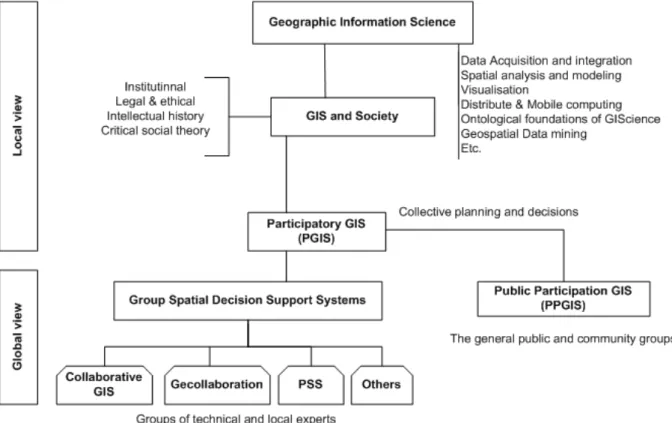
To summarize the hierarchy of collaborative forms in GIScience, figure 1 shows the themes of GIScience and their subareas where PGIS is a more general concept that appears higher in the hierarchy. Both GSDSS (small groups) and PPGIS (large groups) are directly related to Group Decision Making, and are members of the PGIS category. Collaborative GIS, geocollaboration, and Planning Support Systems are considered as GSDSS implementations (Balram & Dragicevic, 2006).
Figure 1. The themes of GIScience and the subareas of collaborative forms (adapted from Balram & Dragicevic (2006))
Several investigations tend towards creating or adapting technology that can support collaboration using geospatial data and models. Some of the research directed to PGIS, as with that directed to Group-SDSS, has considered method and tool development that facilitate spatial thinking and knowledge-structuring-consensus nexus of the participation process.
Collaborative Spatial Delphi (CSD) Methodology is an example of that method (Balram, 2005). More emphasis has been directed to developing collaborative frameworks to support participation of experts or local communities in collaborative spatial planning. Simao et al. (2009); Pirotti et al. (2011); Bugs et al. (2010) are some investigations in this regard.
Actually, collaboration in data production is materialized by the emergence of new forms of data crowdsourcing. Collaborative web platforms like OpenStreetMap (OSM) has demonstrated the potential to revolutionize the way geospatial data can be acquired and shared between users. Anyone with internet access and mobiles devices (Smartphones, GPS, cameras …) has the ability to produce data voluntarily and make it available to a large community of users. As it has been stated by Goodchild (2010), citizens become as “voluntary sensors”. Crowdsourced data called “Voluntary Geographic Information” (VGI) is a potentially attractive source of free information (Goodchild, 2010; Genovese & Roche, 2010). However, its quality cannot be easily guaranteed. Many authors have raised the issue about its credibility and longevity as well as the mechanisms to make it benefic (Goodchild, 2010; Genovese & Roche, 2010; Haklay, 2010).
Research directed to participative or collaborative 3D modeling focus on the utility of the interaction with 3D models to support design and collaboration. In this context, participative 3D modeling is a mapping method based on extracting topographic information (i.e. contour lines) from scale maps, and then constructing a solid 3D model that is used to locate peoples’ spatial memories to facilitate learning, analysis and community involvement with spatial issues related to a territory (Giacomo, 2010). Technologies such as 3D virtual worlds for supporting remote design collaboration, and tangible user interfaces (TUIs) for enhancing co-located design collaboration enable designers to collaborate by interacting with 3D models (Gu et al., 2011).
Finally, there has been a strong drive towards collaborative forms in spatial data in order to solve spatial problems or take common decision or planning actions. Current trends concern Collaborative Spatial Decision Making systems (CSDM) and developing frameworks to reconcile the individual approaches and lead to solutions that satisfy a large number of decision makers with different backgrounds and interests.
In this section, we have given an overview about collaboration and its several forms related to GIScience. Among these forms, we have a particular interest to Collaborative GIS as a potential solution to provide a theoretical and application foundation to conceptualize a distributive turn to planning, problem solving, and decision making by experts (Balram & Dragicevic, 2006). While research investigations have considered collaborative GIS as an architecture where GIS is seen as a technical framework capable of handling CSDM systems, we raise a fundamental need to review its design methods to make the system more relevant to collaborative territorial planning. One of the investigations should be directed to collaboration in the design of models capable of supporting different uses and applications. In the following section, we give our vision about collaborative modeling applied to the 3D domain.
Collaboration in 3D modeling
Our vision of collaboration goes beyond the limited context of spatial decision making. We consider that collaboration should be engaged as a process of collaborative thinking and modeling in order to confront different visions and to design a common model that potential users can enrich by adding thematic knowledge. Our vision is placed in the context of 3D
modeling. We begin our reasoning with the following observation: experience learning has shown that traditional intra organizational 2D models developed for GIS applications cannot be extrapolated to all situations. It seems obvious because individual modeling initiatives were generally conducted to respond to specific needs and data analyzes are encapsulated in a limited application which was developed for. Certainly, standardization exchange formats comprising both spatial and semantic information could improve data usability between heterogeneous environments. However, as semantic heterogeneity obstructs information exchange among applications (Bittner et al., 2005), available solutions for data sharing and reengineering cannot solve all data inconsistencies and interoperability problems.
Furthermore, 3D is not generalized yet and many organizations still work with 2D/2.5D databases. If the data update is the major concern for 2D databases, it is still at the stage of acquisition for 3D data for a number of organizations. Despite the notable achievements realized in the 3D domain, 3D still face many challenges to be generalized. So, collaboration in 3D modeling among several potential producers acting in the same geographic space would be a potential solution to build 3D reference models by sharing knowledge and costs. The challenge is twofold. Firstly, data productions and updating costs will be shared and secondly, data interoperability will be achieved through agreement on common geometric and semantic specifications of the 3D data.
Another major challenge of collaboration in 3D modeling is 3D data coproduction through definition of common specifications in terms of semantics and technical requirements for each class and each level of detail with respect to the required accuracy and precision. The objectives are twofold. Firstly, defining a standard 3D model to solve semantic heterogeneity by confronting different views of experts on a given topic. Secondly, future 3D data acquisition methods will be adopted to produce 3D data compliant to the common specifications. The 3D pilot project, ran in the last few years, is an illustrating example of collaboration resulted in a national 3D standard in Netherlands (see Stoter et al. (2013) for more details).
Finally, collaborative 3D modeling is of a major interest in the sense that it allows to control the differences around spatial modeling born of individual initiatives and sometimes conflicting visions (Hajji & Billen, 2012). So, players involved in the same geographical area, producing and managing the same types of data in the context of similar thematic fields are challenged by unifying their vision around a collaborative 3D model in which collaboration is placed upstream to deal with the conceptual issue of 3D modeling. Thus, a collaborative 3D model will be benefit for various stakeholders by sharing the costs of acquiring and updating 3D data, pooling resources and experiences. So defined, the 3D collaborative model will be a potential collaborative tool in Group Spatial Decision Making and as building block towards 3D Spatial Data Infrastructures.
KEY ISSUES FOR A 3D COLLABORATIVE MODEL
In section1, we have presented our vision about a 3D collaborative model. Obviously, the main raised question will be: how this 3D model should be established regarding the conceptual, the technical and the collaborative aspects? We will start by analyzing the basic questions to be considered about the 3D collaborative model, then conceptual and technical issues will be presented in regards to the collaborative dimension of the 3D model.
Basic questions about a 3D collaborative model
A 3D collaborative model is reached through agreement on common specifications. It can be considered as a framework of basic 3D objects which can be enriched by future users. Thus, a first characteristic of the 3D collaborative model is to be as a reference model for the community of collaborators. A reference data set plays for a geographic information user the same role as a geodetic frame does for cartographers and surveyors. Reference data is used to relate or refer external information to the real world such as infrastructure theme, terrain elevation, hydrography or abstract features like administrative boundaries, cadastral parcels and postal addresses (Neber, 2008). So defined, reference data will constitute a common denominator of multiple applications.
A 3D collaborative model is based on fundamental 3D data that potential producers must make available to deal with a large range of 3D applications. To reach this objective, it seems logical to investigate and rely on user’s 3D requirements (Zlatanova, 2000), to define the types of real world objects the 3D reference model must represent and to choose an appropriate design of an integrated model with interoperability assured. Finally, we argue that reference data concept is relative and associated to fitness of use and then dynamic if we consider that user requirements become more sophisticated when achieving a high degree of maturity.
3D reference objects
3D real objects of interest for urban area are application depending and then different types of objects may be more (or less) relevant than others (Oosterom & Stoter, 2010). Many authors have already addressed the question by identifying main relevant 3D objects for urban applications. As they were been reported by Zlatanova, studies have resulted to convergent classes of interest: buildings, terrain, vegetation, traffic network, public utilities and telecommunications are the main objects to be maintained by in a 3D GIS. Underground infrastructures are also important to handle underground urbanism applications (Zlatanova, 2000; Billen & Zlatanova, 2003). The same author has distinguished four basic groups of real objects: juridical objects (e.g. individuals, institutions, and companies), topographic objects (e.g. buildings, streets, and utilities), fictional objects (e.g. administrative boundaries) and abstract objects (e.g. taxes, deeds, Usage, Usability, and Utility of 3D Urban Models). Basic objects of a 3D model are generally constructed by extending those of traditional 2D models (from 2D to 3D thinking) such as buildings, vegetation, city furniture and so forth. A common understanding is that buildings and terrain objects are the most important features to describe in a 3D city model
User’s 3D requirements
In reality, 3D requirements may be not well known by novice users themselves. Indeed, confronted by organizational, financial and market problems, users can hardly identify revolutionary new requirements (Zlatanova, 2000). Although carrying experiments and ideas (Zlatanova, 2000), they believe 2D technologies sufficient to complete their tasks and then are unable to arise from relevant needs. Zlatanova stated that user’s 3D requirements can be investigated through a technology or an application-driven approach. The former studies the question regarding improvement made in new technologies dealing with 3D information while the later relies on user’s needs. A mix of the two approaches is more appropriated in the sense that users can better understand their needs if they are aware of available 3D
geo-information and the supporting technologies (Oosterom, 2010). So, a reference 3D model should be extensible to respond to future needs and prospective applications.
3D Interoperability
Recognised as a crucial problem for urban information systems, interoperability deals with transferring information between different systems or models with the ability to set up correspondences between concepts from one system to concepts in the other one (Metral et al., 2010). A major part of 2D GIS research has been dedicated to 2D interoperability. However, most of the time, interoperability concerns came after GIS design so causing problems of data exchange. So, it is time to enhance our spatial thinking and design by anticipating reflexion about interoperability at the design stage to overstep the semantic and geometric limitation of 3D city models. There are several ways to deal with interoperability. An ontology-based approach can be used to interconnect urban models in order to improve their interoperability (Metral et al., 2010). Besides, the design of a 3D model compatible with 3D standards is another issue to deal with interoperability. In this case, City GML is a relevant candidate for 3D modeling. CityGML is an object oriented model that allows semantics, geometry, topology and appearance characteristics to be stored per each urban object. Compared to other 3D formats, CityGML proposes a rich semantic and a multi-level representation which is very relevant in spatial applications and can be used as a source or target for generalizations (Gröger & Plümer, 2012).
CityGML is a recommendation of the INSPIRE directive. Several specifications for the building object have been recommended in the context of INSPIRE project. They are referenced in the document D2.8.III.2 INSPIRE Data Specification on Buildings - Technical Guidelines (version of 10/12/2013). In INSPIRE, the theme "Building" is part of the reference data required in the spatial data infrastructure. The data model is based on a flexible approach that allows multiple representations for buildings through four profiles with different geometric and semantic granularities. The "Core" profile represents basic requirements to be implemented. The application schema "Buildings3D" (Figure 2) defines the geometry of the "Buildings" and "Building Part" through a 3D representation based on CityGML levels of details with the possibility to include a 2D representation /2.5D via the attribute "Geometry2D". Extended profiles, such as ″BuildingsExtended3D″ extends the "Buildings3D" one by adding other building components such as openings, interiors installations and textures.
Figure 2. “Buildings3D” profile (INSPIRE Data Specification on Buildings - Technical Guidelines (version of 10/12/2013)
Multi scale representation
Considering that several 3D applications may share a unique 3D reference database, dealing with multi representations is a fundamental issue in 3D modeling. Some of the questions to make up a representation would be: what information to keep? How it is described? How it is organized in terms of data structures? How it is coded? (Parent et al., 2006). Depending on application requirements, a certain spatial and thematic granularity is needed. As it is defined in the CityGML specifications, the concept of level of detail allows representing objects with regard to different degrees of resolution which can be linked to the concept of scale (Van den Brink et al., 2013). Each level of detail is characterized by differing accuracies (described as standard deviation of the absolute 3D point coordinates) and minimal dimensions of features (Gröger et al., 2008). Objects become more detailed with increasing LoD, regarding both geometry and thematic differentiation (Emgard & Zlatanova, 2007). Nevertheless, the accuracy and the description of how rich would be a representation of a building in each level of detail, as described in CityGML, might be confusing. Such an example, a building with internal description compared to LoD4, might be classified in a lower LoD because of a lack of accuracy, so causing a loss of information. To overcome this limitation, the user should be able to state which type of level of detail (geometry or semantic based) is the most appropriated for its application requirements. As it has been also recommended by Van den Brink et al. (2013), the authors argue that the specifications of positional accuracy associated to each level of detail should be ignored. Levels of details are so meaningful in terms of semantic granularity. In this context, (Löwner et al., 2013) proposed a new Level of Detail concept that involves the separation of a Geometrical LoD (GLoD) from that of a Semantical LoD (SLoD). Furthermore, the consistent management of multiple representations is required to allow transformations between levels of details (Breunig & Zlatanova, 2011). Such rules will make a real progress in 3D generalization techniques (Breunig & Zlatanova, 2011). As a recent contribution in this field, Cheng et al. (2015) proposed a methodology framework for automatic transformation of different LoDs in CityGML.
Conceptual and technical issues
3D modeling still faces some impediments to be generalized. The reasons are multiple. This is partly due to a lacking knowledge of the 3D domain and to the lack of a generic approach to handle 3D Geo information (Stoter et al., 2011). Furthermore, city modeling is a complex task due to the great amount of different urban entities that can be considered (Robles-Ortega et al., 2012). In the case of 3D, the complexity increases. So, defining and implementing a detailed 3D model would be challenging, money and time consuming. In the following, we address the design of the 3D collaborative model and the populating approach of the 3D model.
The design of the 3D model
A model is designed by an abstraction of reality in order to make it understandable to the users. It consists of a generic structure that can be populated with instances and includes classes, attributes, relationships, constraints and operations (Stoter, 2004). The consistency of a 3D model is more difficult to specify since user needs are diverse and poorly defined, in terms of types of objects to represent and their geometric and semantic accuracy. In general, levels of detail and precision are application-dependent. Additionally, a reference 3D object such as buildings must be assigned a standard semantic independently of organizational specificities.
As it has been stated before, a 3D collaborative model should be interoperable. CityGML has been elected as a reference 3D standard in order to ensure interoperability and to much the recommendations of the INSPIRE directive. Several solutions can be considered for the representation of 3D buildings according to four levels of detail of CityGML: a same LoD for all buildings, different LoDs within the same data set (some buildings LoD1, others LoD2, LoD3 or LoD4) or make multiple representations in the same data set for the same building. The application schema "Buildings3D" is flexible. It only requires that at least one of the geometries (LoD1, 2, 3 or 4 shown in solid or multi area) is to be supplied through the constraint "MandatoryGeometry".
Figure 3 illustrates our vision about the 3D collaborative model which is based on a progressive approach. As a preliminary version, the 3D model will be generic and designed according some common specifications based on standards (CityGML and INSPIRE directive). Data integration and reengineering will be engaged to populate the model by geometric instances and basic semantics. To be enriched in the future, data acquisition sources are to be defined according common specifications of geometric and semantic accuracy. As a prospective data source, the VGI could be integrated to the model by adopting a quality control process.
Figure 3. The architecture of the collaborative 3D model of buildings Populating the 3D model
Until the third dimension is recognized as a fundamental need, potential producers are likely to develop 3D geospatial databases. Nevertheless, acquiring detailed 3D models is not trivial. Knowing that each audience has a distinct set of 3D data needs, a major concern is how to establish one integrated solution to reconcile divergent and not yet well identified requirements for 3D information. We believe that defining and implementing a complete 3D reference model would be challenging, money and time consuming. A step-wise process may be more appropriate to reach basic requirements which can be enriched and completed since 3D reference geographic information is available.
Advanced data acquisition technologies such as 3D laser scanning and Unmanned Aerial Vehicle (UAV) systems have made 3D data acquisition more convenient and accessible for many applications. However, our reflexion about 3D collaborative modeling as a step wise process relies on reuse and integration of 2D/2.5D data. For long decades, 2D topographic inventories have been developed with rich geometric and semantic information. So, capitalization and reuse of this information, in order to inherit knowledge associated to 2D data, is a promising solution to reach basic requirements of a 3D model. This is a way to link 2D and 3D worlds towards future integrated 3D solutions. In other words, a basic 3D model can be established from existing multi source 2D/2.5D data through a process of information integration and data reengineering. In fact, data integration aims to share and capitalize information from heterogeneous data sources in order to reuse it beyond the context of its creation. While data reengineering is required to match the specifications of the target 3D model.
Based on the assumption that basic objects of a 3D model are constructed by extending those of 2D topographic maps such as roads, buildings, etc. 2D models can be exploited as a building block to establish basic 3D models. Two-dimensional data are transformed into 3D objects, and new entities are created as well as the required topology to provide connectivity (Robles-Ortega et al.2012). In 3D Pilot project, Van den Brink et al (2013) have outlined four technical reasons to preserve information from existing 2D models: to maintain connection to applications which justify the use of 3D, to inherit semantics generally rich for existing data, to possibly generate automatically 3D models from existing data sets and to reuse update
processes, generally well established in 2D. Other motivations concern reducing the cost of data acquisition, assuring consistencies between 2D and 3D data and gradually evolve to future integrated 3D solutions.
Finally, we can state that 2D/2.5D data integration is an essential step to reach a basic 3D collaborative model. Section 3 of this paper addresses this challenging issue through a case study which deals with 2D/2.5D data integration and reengineering in order to match specifications of a building 3D model compatible with CityGML. We have used data from Belgium but the methodology can be easily transferable to other contexts, where 3D data is lacking.
Summary of contributions
In this section, we have presented our thoughts about 3D collaborative modeling. We have analyzed and presented an overview of basic questions to be considered to reach a 3D collaborative model. Then conceptual and technical issues related to the design of the model and its populating through data integration were discussed.
We can state that achievements on collaboration in the 2D domain are generally oriented on data sharing and Spatial Decision Making. Collaboration in conception and design are often conducted by professionals acting in the same organization. Data interoperability realizations are usually restricted to developing standards and exchange formats to share data between different environments. Besides, available data integration methods seek to deal with all data inconsistencies problems because of differing models, ontologies and data specifications. Compared to the 2D domain, collaboration in 3D modeling has some specificities. Indeed, users 3D needs are usually not well known or very basic. So, the implementation of a first prototype of the model will motivate users and generate advanced requirements. The first collaborative 3D model should be flexible enough to allow users to personalize their use and to adapt the available 3D model to their application specific-requirements. Likewise, by the use, they can enhance the geometric and the semantic quality of the model. Furthermore, 3D modeling is still a complex task. In contrast to 2D GIS, 3D GIS interact with more information and require more advanced techniques to reconstruct a 3D representation of each distinct object. Geometric and topological 3D models still need further maturation of their spatial functions (Breunig & Zlatanova, 2011). Additionally, the use of the model often dictates the modeling requirements in terms of the level of detail and the modeling techniques that must be utilized. So, multi-representation of geometry and topology is a challenging solution to manage discretely and continuously changing levels of details (Wu et al., 2010). In regards to 3D interoperability, CityGML, compared to other 3D formats, proposes a rich semantic and a multi-level representation which is very relevant in spatial applications and can be used as a source or target for generalizations (Gröger & Plümer, 2012)
According to the specificities of the 3D domain mentioned above, a step wise methodology is required to collaborate in 3D modeling. A collaborative environment would be benefit to alleviate the complexity of 3D modeling and to integrate several 2D databases to construct a first prototype of the 3D model. This will ensure consistencies between 2D and 3D worlds and gradually evolve to future integrated 3D solutions.
We have discussed conceptual and technical issues about 3D collaborative modeling. However, the collaborative dimension is very decisive for the success of such action. We recognize that the implementation of a collaborative project on 3D modeling is not trivial. The condition of its success relies on the ability to create a real dynamic working group with
mutual commitment of the involved parties. Collaboration should be seen as a dynamic and evolving process. In this context, we think that a voluntarist approach initiated by binding formalized partnerships presents a risk of failure. Whereas setting up of concrete partnership situations based on technical achievements is a good catalyst for a sustainable collaboration. Convinced that demonstration of technical feasibility can stimulate motivation for collaboration, we have realized a case study dealing with data integration for a future 3D collaborative model of buildings based on CityGML.
DATA INTEGRATION FOR A FUTURE 3D COLLABORATIVE MODEL
In this section, we aim to investigate a technical issue about collaboration in 3D modeling by proposing a methodology to match and integrate different datasets to build a 3D model of buildings. It was a proof of concept organized with the help of the Belgian National Geographic Institute and the Department of Geometrology of the Walloon region.
The context
In Belgium, each political region has its own Topographic Inventory (TI), called PICC (Projet Intégré de Cartographie Continue) in Wallonia, URBIS in Brussels capital region, and GRB in Flanders. The National Geographic Institute (NGI) maintains and distributes a large set of geographic data and cartographic products. Although these (TI) are created for similar purposes, their “design autonomy” has resulted in different technical characteristics, and heterogeneous underpinning data models. Typically, building databases are planimetrical in nature and do not include the third dimension.
Through this case study we aim to project our reflexion about 3D collaborative modeling by proposing a 3D common model of buildings and investigating how the existing multi source 2D/2.5D data can be reengineered and integrated into the 3D model compatible with the CityGML standard.
Conceptual definition of the model
The specifications of the 3D model are defined in regards to the conceptual questions discussed in section2. In the context of this study, we are interested to buildings as the main objects of 3D city models. So, the first collaborative 3D model is defined as a building model. As the specifications rely on users requirements, not yet well defined, we can adopt a generic definition of the building object that match the technical specifications of the INSPIRE directive.
For the interoperability of the model, CityGML has been elected as the standard for 3D modeling. As we have already stated, the adoption of CityGML as a reference standard for 3D modeling is motivated by its semantic richness, its support of multi resolution features by means of different levels of details. The multi representation to be assigned to the model is dictated by data sources specifications which are limited to 2D geometry augmented by information about the z coordinate. We have so adopted a basic 3D model based on the building thematic module of CityGML, where buildings are represented by flat roofs and distinguishable thematic surfaces (Ground/Wall/Roof), as described in CityGML. In this way, buildings are represented according the Geometric Level of Details (GLoD1) as defined in (Löwner et al., 2013) (Figure 4).
Figure 4. Representation of buildings with the new GLoD concept (Löwner et al., 2013) Design of the Model
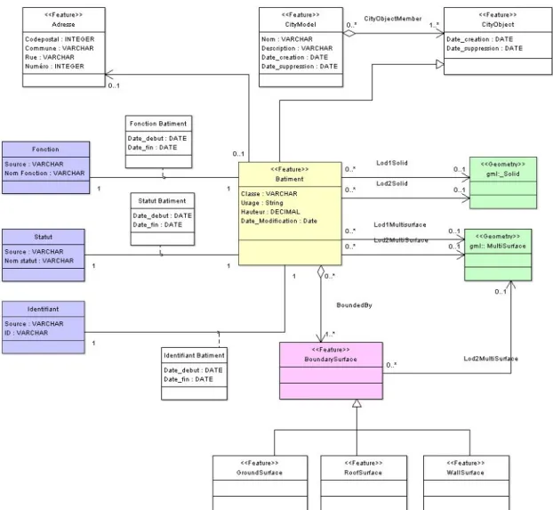
The 3D geometric model of buildings as defined above is adopted as the reference 3D model. Basic semantics is attributed to buildings by adding attributes such as ID, function, usage and status. The adopted 3D conceptual model is presented in figure 5.
Figure 5. The 3D conceptual model of buildings for the Walloon Case Study Populating of the model: Data Integration
To populate the model, three data sources of buildings have been used. The first one is extracted from the PICC map sheets and the second one from the NGI database. Buildings have been restituted by photogrammetry at the cornice level and are represented in a 2.5D
geometry where each (X,Y) point is attributed a value of Z. The third data set is extracted from a cadastral database where buildings are represented by their footprints.
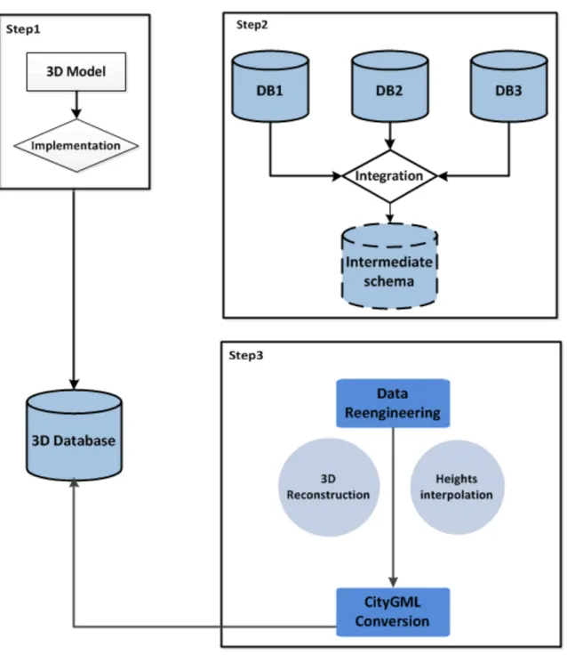
Figure 6 presents the workflow of data integration and reengineering (step 2 and step 3), which are described in the following paragraphs.
Figure 6. The workflow
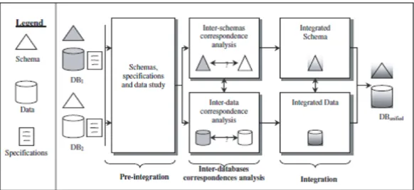
Databases integration is conducted through three main steps: preintegration, data matching and integration or information fusion (Figure 7). We have fixed two main objectives for databases integration. The first one consists of extracting geometric updates from NGI database which is characterized by a good temporal quality. While the second objective aims to extract semantic information about the building function from the cadastral database which represents the highest semantic resolution.
Figure 7. Main steps of spatial databases integration process (Sheeren et al., 2004) Preintegration
The databases to be integrated have been developed independently and are heterogeneous in several respects. Their combination highlights both geometric and semantic conflicts because of different specifications and various modelisations. A worthwhile task was therefore to identify and try to reduce such dissimilarities through a step of preintegration. The preintegration consists of a good understanding of the content of each database and the rearrangement and mapping between models to show similarities and possible connections. As a preliminary task, it was necessary to do preprocessing work in order to unify coordinate systems, to resolve some topological problems and geometric discordances. The taxonomy of Devogele et al. (1998) was adopted as a reference for identifying and classifying geometric and semantic conflicts.
Data matching
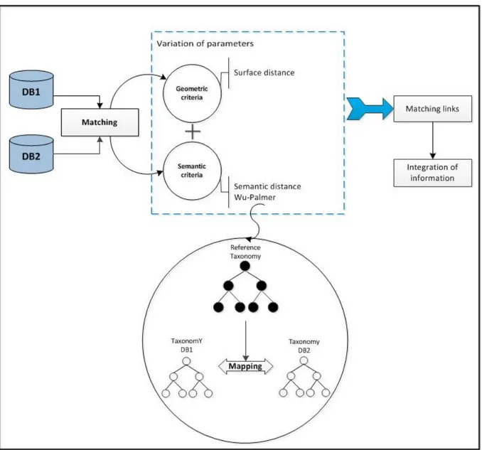
The process of data matching consists of the identification and declaration of correspondences between the elements of the schemas and the geometrical instances of the databases. Different approaches of data matching have been investigated in the research (see Sheeren et al. (2004); Bel Hadj Ali (2001); Beeri et al. (2004); Levenshtein (1966); Raimond & Mustière (2008); Abadie (2012)).
In this case study, data concerns building features. We have so adopted the surfacic distance as a geometric criterion for data matching. In order to enhance the quality of the detection, the “building function” attribute has been added as a semantic criterion. The Wu-Palmer distance was adopted to calculate a similarity index between concepts to be aligned, which is added as an additional criterion with the geometric one to guide the matching process. To do this, a first step was to build a local taxonomy for each schema. Each class value for building function was translated into a concept. Then, taxonomies were aligned using a background one, adopted from Abadie (2012). The matching process is presented in figure 8.
We carried out several tests in order to evaluate the impact of geometric and semantic criteria on matching results, by varying the weight attributed to each parameter. As a preliminary step of the matching algorithm, association’s links are generated between candidate instances by adopting a threshold of 5m to remove parasite intersections. Then, they are filtered in order to eliminate insufficient intersections (with a value of the inclusion function less than 10%).
Two data matching tests were realized. The first one (PICC-NGI) uses the PICC database as a DBRef and the NGI database as a DBComp in order to extract the geometric updates. The second data matching (PICC-cadaster) uses the cadastral database as a DBComp in order to extract semantic information associated to the building function attribute.
Figure 8. The Matching process
The output of the data matching algorithm consists of matching links with different cardinalities ([1-1], [1-n], [n-1], [n-m]). The results are evaluated according two perspectives. A first evaluation aims to highlight the impact of the geometric and semantic criteria then a quantitative assessment is calculated by adopting a manual matching as a reference one. As a first evaluation, we have concluded that the geometric criterion is satisfactory when the difference between databases resolutions is significant. Likewise, the semantic criterion should be introduced as a posteriori decision parameter after a preliminary filtering of the results of geometric matching.
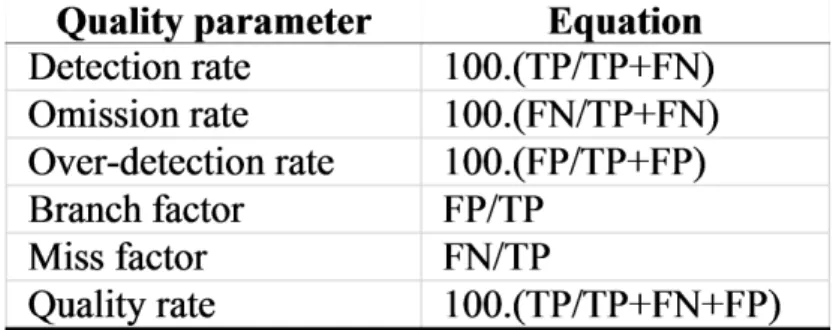
Based on the number of True positives (TP), False Positives (FP) and False Negatives (FN), different quality measures (as presented in figure 9) can be calculated. The quantitative assessment is reported in figures 10 and 11.
Figure 9. Quality measures for data matching (Frédérique, 2008)
Figure 10. Data matching quality (PICC-Cadaster) Figure 11. Data matching quality (PICC-NGI) We have filtered resulting links to maintain only those with a value of 0.4 of the surfacic distance (60% of inclusion) in order to eliminate some links eventually generated between objects semantically similar but with insufficient geometric proximity.
Data Integration (Information Fusion)
The links resulting from the filtering process of data matching (true links) are analyzed for an information fusion. While invalid or "uncertain" links are to be validated by an external source of information. We have considered two types of analysis in accordance with the predefined objectives of the data matching, which consist of extracting semantic information (from cadastral database) and geometric updates (from NGI database). The strategy of information fusion was based on the analysis of the cardinalities of matching links. Semantic information is transferred on the geometric position of the reference object according to the links cardinality, resulting from PICC-cadaster matching. On the other hand, the analysis of the results of PICC-NGI matching has been of a particular interest in the detection of geometric updates which have been exported to the PICC database.
Finally, we have to say that the information fusion is not a trivial task. In case of multiple links (with [n-m] cardinality), an additional source of information is required in order to validate some hypothesis.
Data Reengineering
Data reengineering consists of defining explicit rules to restructure the initial schemas and to translate data according the specifications of the new system. In our case, the layer resulting from information integration has a 2D geometry with shape file format, while the target model
is 3D, based on CityGML schema. Therefore, data should be reengineered in order to match geometric and semantic specifications of CityGML.
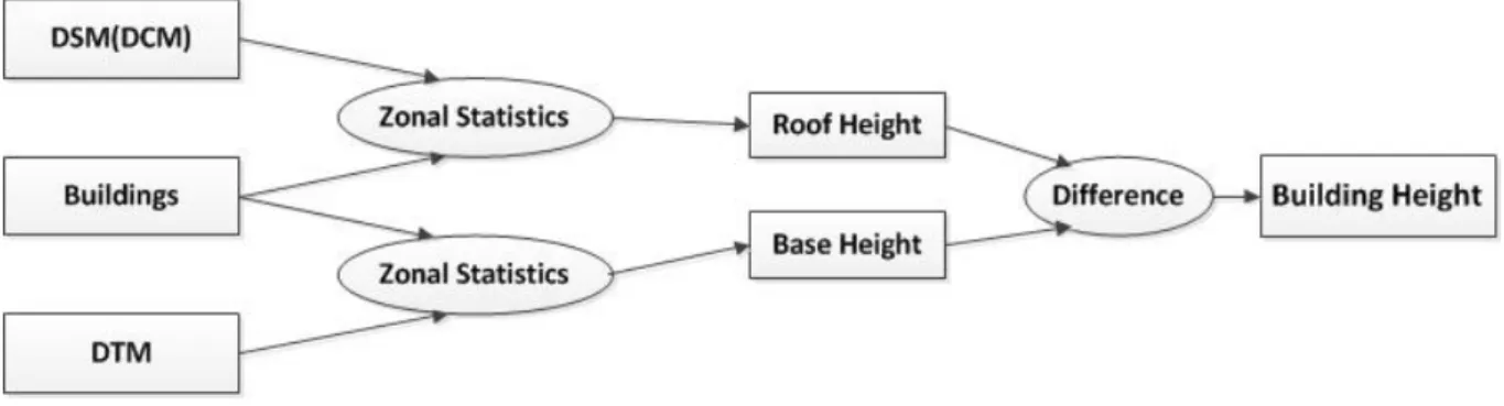
As a first step, we had to interpolate the building’s heights. To accomplish this task, a Digital Surface Model (DSM) was generated from the contours of building’s roofs. While a Digital Terrain Model (DTM) was created from cloud points, axis layers and a selection of terrain characteristic lines. Then, statistical computing was used (through “Zonal Statistics” function of ArcGIS) to extract the height of each building (Figure 12).
Figure 12. Building heights interpolation
Several researchers have studied the issue about 3D reconstruction of buildings and have proposed different methods depending on the initial data source: Pénard et al. (2006); Ledoux & Meijers (2013). Extruding buildings from footprints is the simplest and the well-known method to construct 3D buildings if the topological relationships between the footprints are not taken into account (Ledoux & Meijers, 2013). Constrained by the nature of data source, we have adopted extrusion as a simplest way to construct 3D buildings. Building blocks are obtained from a 2D GIS layer. The value of their height is assigned from the previous process of interpolation. Building’s geometries are then 3D-reconstructed in 3DSMax program. The result is a 3D geometry structured in different layers associated to thematic surfaces of buildings as defined in the building module of CityGML (Roof Surface; Ground Surface and Wall Surface).
After the 3D reconstruction, a process of conversion to CityGML schema is performed. To do this task, FME program was used. The conversion process was done with several transformers. The challenge was to select the adequate ones for the conversion. Many works have addressed the CityGML conversion from shape file data using FME (as (Şengül, 2010)), but there is no unique way to do the conversion because FME provides a large library of transformers and also offers the possibility to develop plug-ins to reconstruct the 3D structure. CONCLUSION AND DISCUSSION
While inter organizational relationships are generally established to respond to a punctual need and are unlikely to be sustainable in the longer term, collaboration between organizations may be seen as an advanced form of cooperation and coordination. Collaboration is a powerful practice to overcome barriers to GIS information sharing and provide a wide array of benefits to collaborators such as cost sharing and experience learning. Research on collaboration has been directed to Group Spatial Decision Making or for creating or adapting technology that can facilitate collaboration using geospatial data and models.
In this paper, we argued the importance of 3D collaborative modeling. We presented and analyzed the concept of collaboration in 3D modeling as a challenging solution to share costs, knowledge and experiences about 3D modeling and to develop an interoperable 3D reference model capable of handling 3D applications. We discussed main issues related to collaborative 3D modeling that have to be considered in the context of designing the 3D model and populating it with existing 2D data.
As a second contribution, we developed and tested, through a case study in Belgium, a process of data integration and reengineering in order to establish a 3D building model reconstructed from existing data and based on CityGML. CityGML has been elected as a reference standard for the 3D model in order to ensure interoperability and to much the recommendations of the INSPIRE directive. Our contribution is conducted to demonstrate the technical feasibility of collaborating in 3D modeling in order to motivate potential data producers and help them to perceive the utility of collaboration in 3D modeling. This work can be considered as a building block of a future collaborative 3D model that can be extrapolated to other similar contexts where 3D data is not well established. However, future investigations are still needed to deal with the enrichment of the 3D collaborative model by considering other data sources and defining specifications for future 3D data coproduction. REFERENCES
- Abadie, N. (2012). Formalisation, acquisition et mise en œuvre de connaissances pour l'intégration virtuelle de bases de données géographiques: les spécifications au cœur du processus d'intégration. Doctoral dissertation, University of Paris-Est, France.
- Antunes, P., Sapateiro, C., Zurita, G., & Baloian, N. (2010, September). Integrating spatial data and decision models in an e-planning tool. In International Conference on Collaboration and Technology (pp. 97-112). Springer Berlin Heidelberg.
- Atila, U., Karas, I. R., & Rahman, A. A. (2013). A 3D-GIS implementation for realizing 3D network analysis and routing simulation for evacuation purpose. InProgress and New Trends in 3D Geoinformation Sciences (pp. 249-260). Springer Berlin Heidelberg.
- Balram S., Dragicevic S. (2006) Collaborative Geographic Information Systems, Chapter1, IGI Global. Copyright © 2006, Idea Group Inc. Copying or distributing in print or electronic forms without written permission of Idea Group Inc. is prohibited
- Balram, S. (2005). Collaborative GIS process modelling using the Delphi method, systems theory and the unified modelling language (UML).
- Balram, S. (Ed.). (2006). Collaborative geographic information systems. Igi Global.
- Beeri, C., Kanza, Y., Safra, E., & Sagiv, Y. (2004, August). Object fusion in geographic information systems. In Proceedings of the Thirtieth international conference on Very large data bases-Volume 30 (pp. 816-827). VLDB Endowment.
- Bel Hadj Ali, A. (2001). Qualité géométrique des entités géographiques surfaciques: Application à l'appariement et définition d'une typologie des écarts géométriques (Doctoral dissertation, Université de Marne-la-Vallée).
- Bittner, T., Donnelly, M., & Winter, S. (2005). Ontology and semantic interoperability. Large-scale 3D data integration: Challenges and Opportunities, 139-160.
- Breunig, M., & Zlatanova, S. (2011). 3D geo-database research: Retrospective and future directions. Computers & Geosciences, 37(7), 791-803.
- Brown, G., & Kyttä, M. (2014). Key issues and research priorities for public participation GIS (PPGIS): A synthesis based on empirical research. Applied Geography, 46, 122-136.
- Bugs, G., Granell, C., Fonts, O., Huerta, J., & Painho, M. (2010). An assessment of Public Participation GIS and Web 2.0 technologies in urban planning practice in Canela, Brazil. Cities, 27(3), 172-181.
- Cheng, J. C. P., & Deng, Y. (2015). Automatic transformation of different levels of detail in 3D GIS city models. International Journal of 3-D Information Modeling, 4(3), 1.
- Dedekorkut, A. (2004). Determinants of success in interorganizational collaboration for natural resource management. Doctor of Philosophy thesis, Florida State University.
- Devogele, T., Parent, C., & Spaccapietra, S. (1998). On spatial database integration. International Journal of Geographical Information Science, 12(4), 335-352.
- Emgard, K. L., & Zlatanova, S. (2007). Design of an integrated 3D information model. Urban and regional data management: UDMS annual, 143-156
- Frank, A. U., Mark, D.M. (1991). Language issues for GIS. Geographical information systems: Principles and applications, 1, 147-163
- Frédérique, B. (2008). Saisie photogrammétrique mult ireprésentation de bâtiments: Une approche Semi-Automatique Initialisée et Supportée par l’Intervention humainE. Doctoral dissertation, Faculty of Graduate Studies, Laval University.
- Freundschuh, S. M., & Egenhofer, M. J. (1997). Human conceptions of spaces: Implications for geographic information systems. Transactions in GIS,2(4), 361-375.
- Genovese, E., & Roche, S. (2010). Potential of VGI as a resource for SDIs in the North/South context. Geomatica, 64(4), 439-450.
- Giacomo, R. (2010). Participatory Three-dimensional Modelling: Guiding Principles and Applications, 2010 edition. CTA, Wageningen, the Netherlands.
- Goodchild, M. F. (2010). Twenty years of progress: GIScience in 2010. Journal of spatial information science, 2010(1), 3-20.
- Gray, B. (1989). Collaborating: Finding common ground for multiparty problems.
- Gröger, G., & Plümer, L. (2012). CityGML–Interoperable semantic 3D city models. ISPRS Journal of Photogrammetry and Remote Sensing, 71, 12-33.
- Gröger, G., Kolbe, T., Czerwinski, A. and Nagel, C. (2008). "OpenGIS City Geography Markup Language (CityGML) Encoding Standard" Version 1.0.0, International OGC Standard. Open GeospatialConsortium, Doc. No. 08-007r1.
- Gu, N., Kim, M. J., & Maher, M. L. (2011). Technological advancements in synchronous collaboration: The effect of 3D virtual worlds and tangible user interfaces on architectural design. Automation in Construction, 20(3), 270-278.
- Hajji, R. (2013). Vers une méthode de conception de SIG 3D collaboratif. Doctoral dissertation, University of Liège, Belgium.
- Hajji, R., & Billen, R. (2012). Towards a collaborative and interoperable 3D Building database– A case study in Walloon region. In Usage, Usability, and Utility of 3D City Models–European COST Action TU0801 (p. 03004). edp Sciences.
- Haklay, M. (2010). How good is volunteered geographical information? A comparative study of OpenStreetMap and Ordnance Survey datasets. Environment and planning B: Planning and design, 37(4), 682-703.
- Jankowski P., Balram S., Dragicevic S., Feick R. (2009). Towards participatory geographic information systems for community-based environmental decision making. Journal of Environmental Management, 90(6), 1966-1971.
- Ledoux, H., & Meijers, M. (2013). Representing three-dimensional topography in a DBMS with a star-based data structure. In Progress and New Trends in 3D Geoinformation Sciences (pp. 119-132). Springer Berlin Heidelberg.
- Levenshtein, V. I. (1966, February). Binary codes capable of correcting deletions, insertions, and reversals. In Soviet physics doklady (Vol. 10, No. 8, pp. 707-710).
- Löwner, M.-O., Benner, J., Gröger, G. & Häfele, K.-H. (2013): New Concepts for Structuring 3D City Models - an Extended Level of Detail Concept for CityGML Buildings. In: B. Murgante et al. (Eds.): ICCSA 2013, Part III, LNCS 7973, Springer, Heidelberg, 466-480.
- McDougall K., Rajabifard A., Williamson I. (2005). What will motivate local governments to share spatial information? In Proceedings of the 2005 Spatial Sciences Institute Biennial Conference: Spatial Intelligence, Innovation and Praxis (SSC2005) (pp. 379-388). Spatial Sciences Institute.
- MacEachren, A. M. (2000). Cartography and GIS: facilitating collaboration. Progress in Human Geography, 24(3), 445-456.
- Metral, C., Billen, R., Cutting-Decelle, A. F., & Van Ruymbeke, M. (2010). Ontology-based approaches for improving the interoperability between 3D urban models. Journal of Information Technology in Construction, 15, 169-184.
- Nedović-Budić, Z., Pinto, J. K., & Warnecke, L. (2004). GIS database development and exchange: interaction mechanisms and motivations. URISA journal, 16(1), 15-29.
- Parent, C., Spaccapietra, S., & Zimányi, E. (2006). The MurMur project: Modeling and querying multi-representation spatio-temporal databases. Information Systems, 31(8), 733-769.
- Pirotti, F., Guarnieri, A., & Vettore, A. (2011). Collaborative Web-GIS design: A case study for road risk analysis and monitoring. Transactions in GIS, 15(2), 213-226.
- Raimond, A. M. O., & Mustière, S. (2008). Data matching–a matter of belief. In Headway in Spatial Data Handling (pp. 501-519). Springer Berlin Heidelberg.
- Robles-Ortega, M. D., Ortega, L., & Feito, F. R. (2012). Design of Topologically Structured Geo-database for Interactive Navigation and Exploration in 3D Web-Based Urban Information Systems. Journal of Environmental Informatics,19(2).
- Schafer, W. A., Ganoe, C. H., & Carroll, J. M. (2007). Supporting community emergency management planning through a geocollaboration software architecture. Computer Supported Cooperative Work (CSCW), 16(4-5), 501-537. ISO 690
- Şengül, A. (2010). Extracting semantic building models from aerial stereo images and conversion to CityGML. Master Thesis, Technical University of Ýstanbul.
- Sheeren, D., Mustière, S., & Zucker, J. D. (2004, September). How to integrate heterogeneous spatial databases in a consistent way?. In East European Conference on Advances in Databases and Information Systems (pp. 364-378). Springer Berlin Heidelberg. - Simao, A., Densham, P. J., & Haklay, M. M. (2009). Web-based GIS for collaborative planning
and public participation: An application to the strategic planning of wind farm sites. Journal of environmental management, 90(6), 2027-2040.
- Stoter J.E (2004). 3D Cadastre. Publications on Geodesy 57. NCG, Netherlands Geodetic Commission, Delft, the Netherlands, 342 p.
- Stoter, J., Beetz, J., Ledoux, H., Reuvers, M., Klooster, R., Janssen, P., ... & van den Brink, L. (2013). Implementation of a national 3D standard: Case of The Netherlands. In Progress and New Trends in 3D Geoinformation Sciences(pp. 277-298). Springer Berlin Heidelberg.
- Stoter, J., van den Brink, L., Vosselman, G., Goos, J., Zlatanova, S., Verbree, E., ... & Thorn, S. (2011, June). A generic approach for 3D SDI in the Netherlands. In Proceedings of the Joint ISPRS Workshop on 3D City Modelling&Applications and the 6th 3D GeoInfo Conference Wuhan, China (pp. 26-28).
- van den Brink, L., Stoter, J., & Zlatanova, S. (2013). Establishing a national standard for 3D topographic data compliant to CityGML. International Journal of Geographical Information Science, 27(1), 92-113.
- Van Oosterom, P., & Stoter, J. (2010, September). 5D data modelling: full integration of 2D/3D space, time and scale dimensions. In International Conference on Geographic Information Science (pp. 310-324). Springer Berlin Heidelberg.
- Wu, M., Guimei, B., Wen, Y., Shen, J., & Chen, T. (2010, June). A 3D topology model for multiple topological representations based on combinatorial maps. In 2010 18th International Conference on Geoinformatics (pp. 1-4). IEEE.
- Zlatanova, S. (2000). 3D GIS for urban development. International Inst. for Aerospace Survey and Earth Sciences (ITC).