Spatial and temporal dimensions of fire activity in the fire-prone eastern
1Canadian taiga
23
Running head: Taiga fires across space and time 4
5
Sandy Erni1, Dominique Arseneault2,5, Marc-André Parisien3, Yves Bégin4 6
7
1. Centre Eau Terre Environnement, Institut national de la recherche scientifique, 490, rue de la
8
Couronne, Québec (Québec) Canada, G1K 9A9. sandy.erni@outlook.com
9
2. Département de biologie, chimie et géographie, Centre d’Études Nordiques, Université du
10
Québec à Rimouski, 300, allée des Ursulines, Rimouski (Québec) Canada, G5L 3A1.
11
3. Northern Forestry Centre, Canadian Forest Service, Natural Resources Canada, Edmonton,
12
Alberta, Canada, T6H 3S5. marc-andre.parisien@canada.ca
13
4. Institut national de la recherche scientifique, 490 de la Couronne, Québec, Qc, Canada, G1K
14
9A9. yves.begin@inrs.ca
15
5. Corresponding author: Dominique Arseneault; Tel: (418) 723-1986 ext 1519; Fax: (418) 724-16
1849; email: dominique_arseneault@uqar.ca
17 18
Keywords : Extreme weather, Fire-free intervals, Fire size, Fire overlaps, Fuel feedback, 19
Predictability of boreal forest-age mosaics, Top-down vs. bottom-up drivers of fire activity,
20
Natural range of variability
21 22
Type of paper: Primary Research Articles 23
Abstract: 24
The forest-age mosaic is a fundamental attribute of the North American boreal forest. Given that
25
fires are generally lethal to trees, the time since last fire largely determines the composition and
26
structure of forest stands and landscapes. Although the spatiotemporal dynamics of such mosaics has
27
long been assumed to be random under the overwhelming influence of severe fire weather, no
long-28
term reconstruction of mosaic dynamics has been performed from direct field evidence. In this
29
study, we use fire length as a proxy for fire extent across the fire-prone eastern Canadian taiga and
30
systematically reconstruct the spatiotemporal variability of fire extent and fire intervals, as well as
31
the resulting forest age along a 340-km transect for the 1840-2013 time period. Our results indicate
32
an extremely active fire regime over the last two centuries, with an overall burn rate of 2.1 % of the
33
land area yr-1, mainly triggered by seasonal anomalies of high temperature and severe drought. 34
However, the rejuvenation of the age mosaic was strongly patterned in space and time due to the
35
intrinsically lower burn rates in wetland-dominated areas and, more importantly, to the
much-36
reduced likelihood of burning of stands up to 50 years postfire. An extremely high burn rates of
37
~5% yr-1 would have characterized our study region during the last century in absence of such 38
fuel age effect. Although recent burn rates and fire sizes are within their range of variability of the
39
last 175 years, a particularly severe weather event allowed a 2013 fire to spread across a large fire
40
refuge, thus shifting the abundance of mature and old forest to a historic low. These results provide
41
reference conditions to evaluate the significance and predict the spatiotemporal dynamics and
42
impacts of the currently strengthening fire activity in the North American boreal forest.
43 44
Introduction 45
The North American boreal forest is strongly shaped by extensive and recurrent wildfires
46
(Payette et al., 1989; Payette, 1992; Stocks et al., 2002; Boulanger et al., 2012). These fire occur
under the compounded influence of several top-down and bottom-up drivers (Parisien et al.,
48
2011; Cavard et al., 2015; Dash et al., 2016), such as ignition agents (Flannigan & Wotton,
49
1991), weather conditions before and during fire spread (Flannigan & Wotton, 2001; Wang et al.,
50
2014), fuel composition and loading (Hély et al., 2010; Héon et al., 2014; Parisien et al., 2014),
51
and landscape physiography (Mansuy et al., 2014). Because most fires are stand replacing
52
(Rogers et al., 2015), boreal landscapes are structured as mosaics of large even-aged forest
53
patches (White & Pickett, 1985). After burning, patches undergo a postfire trajectory of
54
vegetation succession and biomass accumulation until complete or partial destruction by the
55
subsequent fire (Brown & Johnstone, 2011). Consequently, the time since the last fire is an
56
important attribute that determines forest composition and structure and carbon stocks at both stand
57
and landscape levels (Bond-Lamberty et al., 2004, 2007; Taylor and Chen, 2011; Irulappa Pillai
58
Vijayakumar et al., 2016).
59 60
Models suggest that the North American boreal forest will experience a generalised
61
increase of burn rates (percent area burned annually) during the 21st century as a consequence of
62
projected climatic changes (Flannigan et al., 2005; Balshi et al., 2009; Bergeron et al., 2011;
63
Boulanger et al., 2014; Wang et al., 2015). Larger fires, on average, and more frequent large-fire
64
years are predicted (Kasischke & Turetsky, 2006; Ali et al., 2012), with associated impacts on
65
the spatial structure and functioning of the landscape age mosaic (Bond-Lamberty et al., 2007;
66
Johnstone et al., 2011; Kettridge et al., 2015). Indeed, fire activity has already increased during
67
the last 30 years in some areas of the boreal forest and adjacent tundra (Kasischke & Turetsky,
68
2006), a phenomenon that may have triggered shifts to more fire-prone and less-productive
69
ecosystems, as well as to reduced carbon stocks (Lavoie & Sirois, 1998; Johnstone et al., 2010;
70
Mack et al., 2011; Turetsky et al., 2011). In fact, the projected fire activity is unlikely to maintain
forest cover in several of the most fire-prone areas, thereby causing a shift to woodland or
72
nonforest vegetation (Westerling et al., 2011).
73 74
However, most projections of future fire activity are based on climate only and assume no
75
negative feedback of stand age on fire activity (Flannigan et al., 2005; Balshi et al., 2009;
76
Bergeron et al., 2011; Boulanger et al., 2014). Although fire activity has long been considered
77
independent from forest age in the North American boreal forest (Bessie & Johnson, 1995),
78
strong support for an age effect has recently emerged from the monitoring of fire perimeters
79
(Parisien et al., 2014; Bernier et al., 2016; Dash et al., 2016), as well as from exhaustive datasets
80
of fire overlaps over the last few centuries (Niklasson and Granström, 2000; Héon et al., 2014).
81
This age effect has also been documented from various regions around the world, such as the
82
western United States, Portugal and Australia, although the intensity of this phenomenon varies
83
with fire frequency (i.e. encounter rate between new and previous fires), forest types and weather
84
severity (O’Donnell et al., 2011; Price et al., 2010, 2015; Parks et al., 2015, 2016). In the context
85
of climate change, such an age effect would lead to landscape age mosaics with very different
86
properties relative to the age-independent scenario (Fig. 1). First, because the likelihood of
re-87
burning increases with stand-age, the youngest fraction of the mosaic would reduce fire spread
88
across the landscape and would buffer the predicted increase of burn rates. Second, because the
89
age feedback spatially structures the likelihood of burning, the age effect would increase the
90
predictability of fire occurrence across the mosaic. In theory, this buffering and enhanced
91
predictability of the fire activity would increase with the strength of the age effect.
92 93
Yet, because stand-age mosaics are continuously reshaped, evaluating how actual landscapes
94
diverge from the age-dependent scenario is challenging. Understanding the dynamics of
landscape age mosaics requires systematic data on past fire sizes and fire intervals across an area
96
larger that the largest possible fire over a time period longer that the mean fire interval, whereas
97
most fire reconstructions document fire across either the temporal or the spatial dimension, but
98
rarely both aspects. For example, charcoal analysis from sediments provides records of past fire
99
intervals over millennia at given sampling points (Ali et al., 2012; Kelly et al., 2013, Oris et al.,
100
2014) without direct measurement of fire size across space. Conversely, reconstructing the time
101
since the last fire across space documents the size of the most recent fire events (Bergeron et al.,
102
2004) without direct measurement on fire intervals through time.
103 104
To overcome the shortcoming or fire reconstructions not having both temporal and spatial
105
depth, a method has been developed in which fire length is used as a proxy for fire extent. With
106
this method, it has been possible to reconstruct past fire overlaps along a 190-km road transect
107
across the fire-prone eastern Canadian taiga (Héon et al., 2014). This approach allowed a detailed
108
depiction of both fire extents and associated fire intervals over the last two centuries, and was
109
used to document a negative feedback between stand age and the probability of burning. In the
110
present study, we expanded this dataset by sampling an additional 150 km to the south. The
111
resulting 340-km transect covers a geographic gradient of increasing fire size, from south to
112
north, as well as the last 175 years of fire activity (1840-2013) in a region characterized by rapid
113
recent warming (0.5 °C increase in mean June-July temperature per decade since 1975; CRU TS
114
3.21 dataset; Harris et al., 2014).
115 116
The main goal of this study is to use the above-mentioned dataset to reconstruct the
117
spatiotemporal variability of the stand-age mosaic and investigate the effect of its main top-down
118
and bottom-up drivers. Specifically, we evaluate to what extent the landscape age mosaic has
diverged from the age-independent scenario in one of the most fire-prone areas of the North
120
American boreal forest. In doing so, our study also addresses the following questions: i- have the
121
burn rate and response to climate change been buffered by the stand-age feedback? ; i-has the
122
warming trend of the last 40 years led to unprecedented fire activity and novel forest-age mosaics
123
in the context of the last two centuries ; iii- what is our ability to identify areas at high risk of
124
burning across the mosaic?Results will provide reference conditions for evaluating fire impacts
125
on ecosystems and infrastructures over the coming decades.
126 127
Materials and Methods 128
Study area
129
The study transect spans 340 km along the Bay James Road (built in 1971-1972) from
130
north (53°3’ N) to south (51°2’ N) around 77°3’ W (Fig. 2), in the province of Quebec. This
131
region is characterized by a succession of low hills and depressions, made of the gneissic and
132
granitic rocks of the Canadian Precambrian Shield, and forms a regular plateau varying between
133
100 to 200 meters above sea level (Stockwell et al., 1968). Numerous lakes and rivers compose a
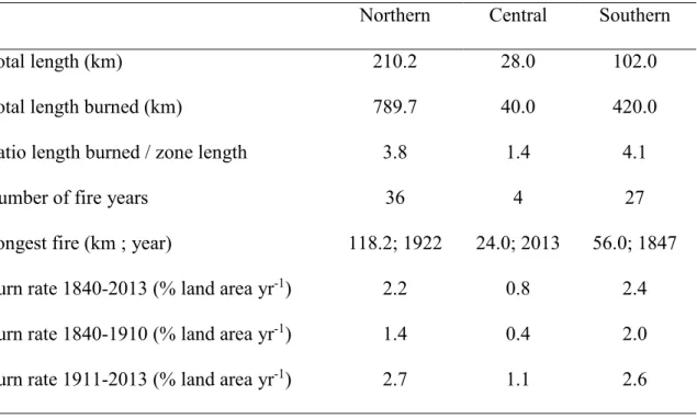
134
dense hydrographic network flowing to James Bay. Peatlands are abundant, covering about
10-135
20% of the landscape. The climate is low sub-arctic with a mean annual air temperature varying
136
between -3.1°C to -2.4°C from north to south, the coldest and the warmest months being January
137
and July, respectively. The average annual precipitation is 683 mm, 40% of which falls as snow
138
between October and May (Environment Canada, 2016).
139 140
The region experiences one of the most active fire regimes and some of the largest recorded
141
fires of the North American boreal forest. Burn rates have averaged 2.4% of the land area per
142
year over the last century and fires larger than 90 km in length have recurred every 20-30 years
(Boulanger et al., 2013; Héon et al., 2014). Detailed fire perimeters of the last 35 years indicate
144
that fire sizes increase from south to north, to the point where the northern half of our sampling
145
transect intersects two of the three largest fires recorded in Canada over the 1980-2013 period
146
(Fig. 2), including the 2013 Eastmain fire (5830 km2). 147
148
The fire season spans from May to September, although most fires occur in June and July.
149
Wildfires are mostly ignited by lightning and there is virtually no fire suppression beyond the
150
immediate vicinity of municipalities and hydroelectric facilities, nor is there any logging or
151
agriculture, allowing us to document a largely natural fire regime. Human ignitions have been
152
responsible for less than 3% of the total area burned since 1973 (Canadian Forest Service, 2016).
153
Black spruce (Picea mariana (Mill.) B.S.P.) and jack pine (Pinus banksiana Lamb.) dominate the
154
landscape. Both species are fire adapted and regenerate quickly after fire from aerial seedbanks
155
stored in their serotinous cones (St-Pierre et al., 1992; Sirois, 1995). Eastern larch (Larix laricina
156
(Du Roi) K. Koch) is frequent but rarely dominant. Broadleaved taxa are rare, covering less than
157 5% of the landscape. 158 159 Field sampling 160
Even if North American boreal fires are generally stand replacing, numerous surviving
161
trees develop fire scars at the margin of unburned forest patches or within less severely burned
162
areas. Thus, by systemically sampling fire scars and establishment dates of trees into a series of
163
contiguous and sufficiently large cells along a road transect, it is possible to reconstruct the
164
length intersected by each fire that spread across the transect (hereafter "fire length") during the
165
last two centuries (Héon et al., 2014). In their study, Héon et al. (2014) sampled 93 cells of ~2
166
km x 1 km along a 193-km transect between the Eastmain and La Grande rivers along the James
Bay road. Using the same method, we extended this transect by an additional 150 km, thus
168
sampling 75 new 2-km2 cells (Fig. 2). 169
170
Within each cell, we exhaustively surveyed areas of potentially low rate of fire spread
171
(stream, lake and peatland margins; rocky outcrops; topographic breaks; uneven or open forest
172
stands) to sample fire scars and establishment date of trees (trunk cross-section) on live trees,
173
snags, or woody debris. Large stems with multiple scars were always preferred over isolated
174
scars as they are more likely to record short fire intervals. We also systematically favoured jack
175
pine over black spruce or eastern larch stems due to its more rapid postfire regeneration, faster
176
juvenile height growth, and its proneness to develop multiple scars. Tree stems were sampled into
177
each cell (average of 13 stems per cell) with the goal of obtaining duplicates of as many different
178
fire dates as possible over the last two centuries. In order to optimize sampling, fire intervals
179
were estimated in the field from tree ring counts on stems cross sections; each sample suggesting
180
a new fire date was brought to the lab whereas those indicating an already duplicated fire date
181
were disregarded. For each sample, we recorded the species, the sampling height, stem type
182
(living, snag, woody debris), stump type (attached to the trunk or not), and GPS location.
183 184
A ~20-km sectionin the center of the transect (km 220-240) was occupied by old black
185
spruce stands (>300-400 years old) with rare or absent jack pine trees and few or no fire scars. In
186
this section, three dominant black spruce stems were sampled at the root collar on at least two
187
hilltops in each cell in order to estimate minimum stand age. This strategy was also applied
188
locally between km 294-302 and km 316-340 of the transect (Fig. S1) in order to reconstruct 19th -189
century fires because these two sections comprised only relatively recent (>1835 and >1900,
190
respectively) jack pine material.
192
In the laboratory, each cross section was finely sanded so that tree rings and fire scars could
193
be distinguished under a binocular microscope. We dated fire scars from living trees by counting
194
tree rings from the sampling year, considering also diagnostic light rings as a validation tool.
195
Scars from dead trees and from trees with suppressed growth sequences were first crossdated
196
from a master chronology. Ring widths were measured and crossdated using Past4 (SCIEM,
197
2011) and COFECHA (Holmes, 1983). Fire dates where also deduced from establishment dates
198
of live or dead pine trees that contained a trunk cross section with pith at a sampling height of
199
less than one meter on stems with an attached stump. Following Héon et al. (2014), the
200
establishment date at root collar was estimated from the first tree ring at sampling height, after
201
adding a correction for the time lag between these two levels: C = 0.1154 H, where C is the
202
correction (years) as a function of the sampling height H (cm).
203 204
Data Analysis
205
We applied some rules to reconstruct the sequence of fire years into each sampling cell
206
(Fig. S1). First, each fire date had to be replicated by at least one scar or one corrected
207
establishment date from the same cell or from one of the two adjacent cells. Fire years from
208
establishment dates and scars were assigned to the same fire year if they formed a continuous
209
sequence along the transect. Second, fire events only documented from establishment dates (i.e.,
210
no available scars) received the date of the oldest available tree ring from the corresponding
211
sample ensemble. The dataset from the first 193 km at the northern end of the transect is
212
considered to be complete for the period 1810-2013 (Héon et al., 2014). However, very few fire
213
scars or basal samples from pine trunks could be found predating a large 1847 fire at km 234-298
214
in the southern extension of the transect. Consequently, we retained the period 1840-2014 for
analysis along the entire transect. Nonetheless, fire dates earlier than 1840 were considered for
216
determining the time elapsed between the corresponding fire and the next subsequent fire
217
(beyond1840) in the same cell. In this study, we considered a total of 2062 dead or living trees
218
sampled in the 166 cells of the transect, including 1196 trees sampled by Héon et al. (2014)
219
(Table S1). These samples provided 3197 fire dates from 1834 fire scars and 1363 establishment
220
dates (Table S1). Because only two fire dates need to be found per 4 km2 to confirm a fire date 221
within a cell (i.e. a scar or establishment date within a given cell or one of the two adjacent cells),
222
we believe that exhaustive and repeated surveys of each cell allowed most fire to be detected.
223 224
Using fire years within sampling cells, we computed fire length (total distance burned
225
during each fire year), fire-free intervals (FI; number of years between each pair of consecutive
226
fire years within each cell), and time since previous fire (TSF; number of elapsed years since the
227
previous fire year) of the 1840-2014 time period in each cell. In order to emphasize longitudinal
228
patterns of fire activity, the entire transect was subdivided into three homogeneous sections,
229
northern, central and southern, based on contrasted patterns of fire lengths, fire intervals and
230
forest composition (Fig. 3a and S1 and Table 1). Although the northern (km 0 - 210) and
231
southern (km 238 - 340) sections have experienced similarly short fire intervals, fires were much
232
longer in the north. In contrast, the central section (km 210 - 238) has been characterised by very
233
long intervals along with the absence of the fire-dependent jack pine (Fig. S1), and was thus
234
considered as a fire refuge sheltered from recurrent fires. For each year, we then computed the
235
relative abundance (% of transect length) of nine successive TSF classes (0-10, 11-20, 21-30,
31-236
40, 41-50, 51-60, 61-70, 71-100, >100 years since previous fire) for the transect sections and the
237
entire transect.
238 239
Burn rates (percent land area burned per year) were computed for selected time periods and
240
the northern and southern sections by summing all distances burned and dividing by the duration
241
of the time period of interest (the central section was excluded because of its short length and low
242
fire occurrence). Burn rates were also computed by age classes (1-20, 21-40, 41-60, 61-80, >80
243
years) for the northern and southern sections and for selected time periods. To accomplish this,
244
we divided FI by TSF frequencies within each class, as these values represent the distance
245
(number of cells) that burned for a given age relative to the distance available to burn,
246
respectively (Héon et al., 2014). Confidence intervals of the FI/ TSF ratio were estimated by
247
bootstrapping. For each age class, the FI/TSF ratio was computed 10 000 times from random
248
samples of the original data, and the 95% confidence limits were estimated from the 2.5% and
249
97.5% percentiles. Burn rates computed from fire lengths are similar to rates computed from the
250
surface area of fire polygons (Héon et al., 2014).
251 252
Because wet areas are known to influence fire spread and fire recurrence (Hellberg et al.,
253
2004; Senici et al., 2015), we verified if the number of fire events detected in each cell decreased
254
with increasing abundance of peatlands and lakes in areas surrounding cells. The number of fire
255
recorded in each cell during the 1840-2014 period was compared to the cover of wet areas (lakes
256
plus peatlands) within buffers of 2.5 km from the centroid of cells. Larger buffers were not
257
considered as they imply strong autocorrelation between successive cells. Peatland and lake cover
258
areas were obtained from governmental digital maps at scale 1:50 000 (Natural Resources
259
Canada, 2006). We grouped cells by the number of detected fire events (n fires = 1-2, 3-4, 5-6,
7-260
8) and compared the median cover of wet areas among groups. For each group, the median area
261
was computed 10 000 times from random samples of the original data, and the 95% confidence
262
limits were estimated from the 2.5% and 97.5% percentiles.
264
Effects of weather and climate on fire spread and length burned were analysed for two
265
spatio-temporal domains. First, for the northern and southern transect sections, we used
266
superposed epoch analysis along with the gridded CRU TS 3.21 dataset (1901-2012; Harris et al.,
267
2014) to verify if fire years of the 1901-2012 time period have been characterized by significant
268
anomalies of monthly mean maximum temperature (MTmax), monthly total precipitation
269
(MPcp), and Monthly Drought Code (MDC) for the months of May, June, July, as well as the
270
combination of June and July. More than 95% of the total area burned between 1980 and 2013 in
271
our study region corresponds to fires ignited during these three months. We averaged 36 cells of
272
the CRU dataset between 51° and 54° W and 75.5° and 78.5° N. We performed the analysis
273
separately for large fire years (total length burned ≥10 km; n = 16) and less important fire years
274
(<10 km; n = 16). The MDC, which is computed from MTmax and MPcp, is a monthly version
275
of the Drought Code of the Canadian Fire Weather Index System and is a good predictor of the
276
area burned annually during the last 30–40 years across the Canadian boreal forest (Girardin &
277
Wotton, 2009). Confidence intervals (P=0.05 and 0.01) of the superposed epoch analysis were
278
determined by bootstrapping.
279
280
Second, the 2013 Eastmain fire burned for 5 weeks under an array of weather and
281
landscapes conditions and offered us an exceptional opportunity to examine the bottom-up and
282
top-down controls on the fire as it was developing. We thus compared the map of daily fire
283
progression built from MODIS data (Parks, 2014) with time series of the Canadian Forest Fire
284
Weather Index (FWI) during the 2013 fire season. The FWI combines values of temperature,
285
relative humidity, and wind speed at noon, and 24-h precipitation to evaluate potential fire
intensity, with higher values indicating greater fire danger (Van Wagner, 1987). We also
287
examined the entire daily FWI record from the La Grande weather station (1977-2013; n = 6147
288
days) to verify if the 2013 fire weather was unprecedented.
289 290
Results: 291
Length burned and fire intervals in space and time
292
High burn rates and large fires have characterised most of the study transect since 1840
293
(Fig. 3). The overall burn rate was 2.1% of the land area yr-1 for the entire transect over the 1840-294
2013 time period. In total, fires have intersected the transect over a cumulated length of 1242 km,
295
including 372 km in 1840-1910 (1.1 times the transect length) and 870 km in 1911-2014 (2.6
296
times the transect length). The ten most important fire years were 1922 (124 km), 2013 (99 km),
297
1989 (96 km), 1941 (95 km), 1847 (84 km), 1972 (80 km), 1916 (64 km), 2005 (49 km), 1854
298
(45 km), and 1983 (40 km). Together these major fires intersected 775 km and corresponded to
299
62.4% of the total length burned since 1840 (Fig. S2). Similarly, fire years with length greater
300
than 10 km (n=25) intersected 1118 km and corresponded to 90% of the total distance burned.
301 302
From 1840 to 2013, a fire occurred on average every 3.5 years somewhere along the
303
transect (Fig. 3a). Considering the entire transect, time intervals between successive fire years
304
varied between one year (12 instances) and 10 years (1926-1936). Individual cells have recorded
305
between 1 and 8 fire events and an average of 3.7±1.5 (mean ± SD) fires per cell. Fire-free
306
intervals within individual cells have varied between 2 years (1852-1854 and 1939-1941) and
307
>308 years (1701-2013), this latter value being underestimated due to the absence of fire scars
308
and pine stems across the five corresponding cells (cells 15, 16, 18, 19, 22; Fig. S1). In total, 58%
and 26% of the cellwise fire-free intervals that ended after 1840 were shorter than 50 years and
310
25 years, respectively, and only 10% exceeded 100 years (Fig. S2).
311 312
The northern section has experienced much larger fires than the southern section during the
313
20th century, as reflected in the mapped fire perimeters of the 1980-2013 time period (Fig. 2). 314
Five fire years intersected the road transect over more than 50 km in the northern section after
315
1920, compared to none in the southern section (Fig. 3b). The large fire years of the 20th century 316
in the northern section were more regularly spaced in time than the shorter fires of the southern
317
section, which were mainly clustered during the 1910-1930 and 1990-2010 time periods (Fig. 4a,
318
b). The largest fire year of the 19th century (1847) occurred mainly in the southern section, this 319
fire being the only one that exceeded 50 km over the entire transect before 1922, suggesting that
320
the two sections have experienced less contrasted fire sizes during the 19th century. 321
322
Fire years were mostly asynchronous and length burned annually was not correlated (r =
-323
0.08) between the northern and southern sections (Fig. S3). Of the 50 fire years recorded along
324
the transect, only 12 were common to both the northern and southern sections. Nevertheless,
325
when considering the total distance burned per 25-year time periods, the southern and northern
326
sections have experienced remarkably synchronous trends of high burn rates since 1840,
327
including an abrupt increase from ~1% yr-1 to ~3% yr-1 around 1920, and peaks of ~4% yr-1 328
around 1940 and 2010 and depressions of ~1% yr-1 around 1910 and 1970, respectively (Fig. 4d). 329
In these two sections, the recent increase in burn rate is thus included within the range of
330
variability of the 1840-2013 time period, though nearing its upper limit. In contrast, the
331
intervening central section has been characterised by an almost complete absence of fire before
332
the 2013 Eastmain fire, which intersected 88% of the section (Fig. 3a). Overall, the central
section experienced a mean burn rate of 0.8% yr-1, but this rate fall to 0.3% yr-1 when excluding 334
the 2013 fire.
335 336
Climate and weather
337
At the inter-annual scale, superposed epoch analysis reveals that large fire years (length
338
burned ≥10 km) are significantly associated with summer temperature and drought anomalies.
339
Large fire years have been characterized by higher June, July and June-July temperatures and
340
MDC than the preceding or following five years in the northern and southern sections (Fig. 5). In
341
contrast, precipitations anomalies were significantly associated with large fire years only in the
342
northern section for the month of June and June-July (Fig. S4). Less important fire years (length
343
burned <10 km) were characterised by average temperature, precipitation, and drought conditions
344
along the entire transect (Fig. S5).
345 346
During the 2013 Eastmain fire, extreme daily fire weather, in conjunction with fuel age,
347
was a strong determinant of area burned (Fig. 6). The fire was ignited by lightning on June 9,
348
2013 and progressively expanded within a large area of forest stands older than 40 years during
349
an episode of moderate-to-high FWI values until July 2. During the last few days of this
350
sequence, the northern border of the fire perimeter was apparently constrained by the adjacent
351
very large 1989 fire (fuels then 24 years of age; Fig 6b). Subsequently, during July 3-4 the fire
352
grew extremely rapidly (2348 km2 in 48 hrs) under the 8th and 10th most extreme daily FWI 353
values of the 1977-2015 period recorded at the La Grande weather station (Figs 6c and S6).
354
These high FWIs resulted from high temperatures (26-28 °C at noon), as well as strong winds
355
(mean speed of 33 km/hr) and low precipitation during the previous month (34.6 mm since June
356
5th, as compared to the June normal of 65.3 mm). During these two days, the fire re-burned the 357
1989 fire to the north, as well as part of the 2005 fire (fuel age: 8 years) to the southeast, and
358
spread across the fire refuge of the central section. The fire was extinguished by rain on July 10
359 (25 mm recorded at La Grande). 360 361 Bottom-up drivers 362
The strong negative feedback already observed between burn rates and fuel age for the first
363
193 km of the northern section (Héon et al., 2014) also apply to the southern section (Fig. 7a),
364
despite difference in average fire size, number of fires, and fire years between these two sections.
365
Burn rates progressively increase from about 1.3% yr-1 in forest stands less than 20 years old to 366
more than 5% yr-1 in stands older than 50 years for the period 1910-2014 and 1840-2014 in the 367
northern and southern sections, respectively. However, age-specific burn-rates have been higher
368
in young stands (<50 years) of the northern section than the southern section during the 20th 369
century.
370 371
In addition to the bottom-up effect of stand age, the number of fires recorded per cell
372
decreases with increasing wet areas in buffers of 2.5 km around cells (Fig. 7b). Cells surrounded
373
by 5-12% of wet areas tended to experience between 5 and 8 fires, as compared to 1-2 fire events
374
for cells surrounded by 16-26 % of wet areas. These latter cells are concentrated into the central
375
section, which cover 8.2% of the total transect length, but contains 42% of all cells that recorded
376
1-2 fires. In the central sections 100%, of all cells recorded 1-2 fires and 2.5-km buffers around
377
cells comprise 24% of wet areas.
378 379
Spatio-temporal variability of the stand age mosaic
The forest age mosaic has been highly variable in space and time. Although a high
381
frequency of small fire years maintained a relatively stable age structure in the northern section
382
prior to 1920, large fires every 20-30 years subsequently generated large temporal variations in
383
forest age (Fig. 4a). The northern section was successively dominated (40-60 % of the section
384
length) by forest stands aged 1-10 years (in 1930, 1950, 1995), 11-20 years (1935, 1955, 2005),
385
and 21-30 years (1965, 2000). In comparison, the grouping of smaller fires within the 1847-1864,
386
1910-1930, and 1990-2010 fire episodes in the southern section generated slower age structure
387
fluctuations with age classes of less than 70 years successively peaking every 60-80 years (Fig.
388
4b).
389 390
Even though the study transect was dominated by young forest, with stands <50 years old
391
covering 58.4% ± 8.6% and 76.2% ± 7.4% of the transect length over the 1840-1919 and
1920-392
2013 time periods, respectively, old-growth forest stands (>100 yrs old) had persisted in the fire
393
refuge of the central section before the 2013 Eastmain fire (Fig. 4c, 8). Indeed, the forest age
394
along the transect for years following the most important fire years indicates that the Eastmain
395
fire shifted the overall age mosaic outside its range of variability of the last 175 years (Fig. 8).
396
The fire almost entirely burned the last remaining old-growth forest patch that had escaped fire in
397
the central section since at least the early 19th century, such that only three cells greater than 100 398
years old (established after the 1847 fire at km 236-240 and the 1882 fire at km 12-14; 1.8% of
399
the transect length) remain today. Moreover, forest stand older than 70 years are also near their
400
minimum for the last 175 years (currently 15.1% of the transect length vs. minimum of 9.8% in
401
1973-1976) such that, even with a complete absence of fire, at least 25 years will be needed for
402
the re-emergence of a near-average fraction (10.5%) of forest stands older than 100 years. The
longest remaining patch of mid-to-late successional forest is currently 74 years old (established
404
after the 1941 fire) and covers 8.3% of the transect at its northern end (km 0-28).
405 406
Discussion: 407
Our sampling design allowed the fire activity and associated landscape age mosaic to be
408
reconstructed from direct field evidence within a spatiotemporal domain of 340 km and 174
409
years, with resolutions of 2 km and 1 year, respectively. Each fire event detected was explicitly
410
located within this domain, thus allowing the variability of fire lengths and fire intervals, as well
411
as the resulting forest age, to be reconstructed across space and time. Our results indicate that this
412
part of the eastern Canadian taiga has been characterised by an extremely active fire regime and a
413
variable stand-age mosaic that has strongly diverged from the age-independent scenario of a
414
randomly structured landscape (Fig. 1). Specifically, previous fires and wet areas strongly
415
controll the regional fire activity across space and time such that burning young forests and areas
416
fragmented by wetlands and lakes had to be triggered by severe drought and weather events, as
417
was the case with the exceptional 2013 Eastmain fire. These results help understand and predict
418
the dynamics and impacts of the currently strengthening fire activity in the North American
419
boreal forest.
420 421
Structured vs. random age mosaic
422
Our exhaustive record of fire lengths allowed us to compare fire activity and monthly
423
climate data over a period of 112 years. Anomalies of summer drought severity and high
424
temperatures have been important top-down driver of area burned annually along the entire
425
transect, mainly through their influence on the development of large fires (i.e. fire length greater
426
than 10 km), which accounted for 90% of the total distance burned during the last 175 years. This
dominant role of temperatures and drought in our study area is coherent with most studies of fire
428
activity in the North American boreal forest, although the relative influence of these two factors
429
varies among regions (Duffy et al., 2005; Flannigan et al., 2005; Balshi et al., 2009; Parisien et
430
al., 2011; Ali et al., 2012; Boulanger et al., 2013). Moreover, despite asynchronous fire years
431
between the northern and southern sections of the transect, drought and temperature anomalies
432
most likely synchronized interdecadal trends fire of activity at the regional scale (Gavin et al.,
433
2006), as both sections experienced synchronous decadal burn rates and a similar influence of
434
temperature and drought on large fires. Ultimately, this synchronizing top-down influence may
435
have been forced by large-scale climate patterns driven by oceanic temperatures (Girardin et al.,
436
2004; Le Goff et al., 2007).
437 438
Despite the strong link between monthly climate and annual area burned, wildfire spread is
439
in fact largely driven by day-to-day variation in weather following ignition (Abatzoglou and
440
Kolden 2013). For example, the 2013 Eastmain fire, which is the second largest fire of our
441
dataset, shows how a few days of extreme fire weather, characterized by strong winds and high
442
temperatures had a disproportionate influence on area burned. In its early phase, the Eastmain fire
443
progressively expanded across a large area of mature forest stands under relatively sustained
444
severe fire weather and then spread very rapidly across any fuel types during two consecutive
445
days of extremely severe fire weather conditions. Such extreme conditions probably contributed
446
also to the spread of the largest fire of our dataset (1922 fire; 124 km), as suggested by its 50-km
447
overlap with the 1917 fire (fuel then aged 5 years) at km 135-185 (Fig. 3). Flat topography and
448
prevailing winds parallel to rivers and landscape orientation (east-west) may have amplified the
449
effect of weather during the development of these very large fires (Mansuy et al., 2014).
450 451
Despite strong top down influences of climate and weather, our study area is clearly an
age-452
dependant stand-age mosaic (Fig. 1; Héon et al., 2014; Parisien et al., 2014; Parks et al., 2015,
453
2016). In fact, the burn rate of 5.5 % yr-1 in forest stands older than 50 years during the 20th 454
century, compared to rates of 0-1.5% yr-1 in stands of less than 20-years-old (Fig. 7a), indicates 455
that the age-dependent resistance to fire activity is considerable and that an extremely high burn
456
rates of ~5% yr-1 would have characterized our study region during the last century in absence of 457
a fuel age effect. An overall burn rate of 5% yr-1 would have been almost two times greater than 458
the highest rates recently observed within the most fire-prone areas of the Canadian boreal zone
459
(Boulanger et al., 2012). Although it has long been assumed that fires occur independently of
460
forest age in the North American boreal forest (Bessie & Johnson, 1995), our results clearly show
461
that this is not always the case.
462 463
Several phenomena can explain the strength of age-dependant resistance to fire. First, because of
464
its high burn rate relative to the rate of postfire fuel recovery, our study area has been
465
characterised by frequent encounter of immature fuels by spreading fires, thus increasing the
466
strength of the age effect as compared to other regions of the North American boreal forest where
467
no such effect was detected (Price et al., 2015). Second, although almost any fuel type can burn
468
during extreme fire weather, as shown in the Eastmain fire and elsewhere in North America
469
(Parks et al., 2015), such extreme conditions are rare by definition and do not occur during all
470
fires or through the entire growth of a given fire event. For example, the extraordinarily rapid
471
growth observed during the last stage of the Eastmain fire was triggered by one of the two
472
sequences of two consecutive days with a FWI index value greater than 50 to have occurred since
473
1977 in the study area. Third, age-independent fire progression during extreme weather is in fact
474
spatially dependant on prior age-dependant growth of the same fire during less extreme weather,
as also evidenced by the early progression of the Eastmain fire (Fig. 6a). That a fire perimeter of
476
more than 150 km was already active at the onset of the final sequence in 2013 permitted
477
considerable fire growth during the following two days. Fourth, compared to other fuel types the
478
flammability of mature conifers increases disproportionately with elevated temperature and
479
drought, leading to the preferential development of large fires within large patches of mature
480
conifers (Dash et al., 2016; Bernier et al., 2016). Fifth, fuel age is likely to influence not only fire
481
spread but also ignition (Krawchuk et al., 2006). Finally, because fire is a spatially contagious
482
phenomenon, fire-resistant landscape patches will not only reduce fire activity within their
483
interior, but also outside their boundaries, creating a "fire shadow" (Finney, 2005; Parisien et al.,
484
2010).
485 486
In addition to the transient effect of forest age on landscape-level flammability, lakes and
487
large peatlands represent additional bottom-up impediments to fire ignition and spread.
488
Increasing lake and peatland abundance at distances of at least 2.5 km has considerably reduced
489
fire recurrence within sampling cells (Fig. 7b). This effect has been most evident in the central
490
section before the 2013 fire, demonstrating that large sectors can escape fire repeatedly, even
491
within the most fire-prone regions of the boreal forest. It is well known that individual sites may
492
escape fire (Wallenius et al., 2004; Cyr et al., 2005; Ouarmim et al., 2015) due to poor drainage
493
conditions and high lake or wetland abundance in their surroundings (Hellberg et al., 2004; Cyr
494
et al., 2005; Madoui et al., 2011; Barrett et al., 2013; Senici et al., 2015). These fire refuges, with
495
their associated biodiversity and high carbon stocks are important features of these landscapes
496
(Hornberg et al., 1998; Ouarmim et al., 2014). In our study area, the lack of fire eventually leads to
497
jack pine exclusion and to the development of overmature spruce stands (LeGoff and Sirois, 2004)).
498 499
Because lakes and peatlands tend to promote the persistence of old forest stands, whereas
500
stand age per se has the opposite effect, these two resistance mechanisms would have tended to
501
mask each other’s effect in our dataset. Thus, a stronger age-dependence of burn rates may have
502
been documented in the absence of lakes and peatlands and a stronger wet area-dependence may
503
have been detected in absence of stand age effect. For example, the apparent decrease of burn
504
rates in forest stands more than 60 years old (Fig. 7a) probably reflects the tendency of these old
505
stands to develop and persist in areas resistant to fire due to high lake and peatland cover. The
506
alternative explanation that overmature spruce stands decrease in flammability is not supported
507
by recent studies showing that these stands are positively selected by fire across the North
508
American boreal forest (Bernier et al., 2016; Dash et al., 2016).
509 510
Although interactions among lake and peatlands and stand age are probably spatially
511
complex, collectively these factors would help identify areas at greater risk of burning (e.g. large
512
forest patch more than 50-years-old containing few lakes and peatlands), as well as infrastructure
513
exposure to fire in the current context of increasing fire activity. For example, the large sector
514
that has escaped fire for several decades in the surroundings of the La Grande weather station at
515
the northern end of the transect (Fig. 2) corresponds to an unusually persistent large area of old
516
forests in the context of the last century (km 0-50 in Figs 3 and 8) and comprises several strategic
517
hydroelectric infrastructures along with the towns of Chisasibi, Wemindji, and Radisson. Burn
518
probability modelling using fire growth algorithms would help map fire likelihood around
519
infrastructures, given the surrounding land physiography, hydrography and fuel types (Finney,
520
2005; Parisien et al., 2007).
521 522
Spatio-temporal variability vs. recent and future trends
Our study supports previous assertions that regions experiencing very large fires have
524
inherently unstable fire regimes because fires are so large that no fraction of the total landscape can
525
represent its entirety; that is, no section comprises the same age classes frequency distribution as the
526
total landscape (Romme, 1982; Baker, 1989; Turner et al., 1993). Although a relatively stable age
527
mosaic prevailed in the northern section of the study area during the 19th century due to relatively 528
small and regular fire events, large and irregular fires in the rest of our spatio-temporal domain
529
clearly resulted in an unstable, oscillating landscape-age mosaic.
530 531
Consequently, because of high background variability, along with buffering of burn rates
532
by bottom-up resistance, long records of fire size, fire intervals, and burn rates are necessary to
533
determine if the recent warming trend has shifted the fire regime outside range of variability. For
534
instance, even though it may be fairly exhaustive, the atlas of fire perimeters in Canada
(1980-535
2013; Fig. 2) is too short to provide an adequate reference period. In addition, the increase of
536
burn rates with temperatures may be altered by the confounding influence of precipitation and
537
drought (Girardin and Muldesee, 2008). For example, although a rising trend of burn rates is
538
evident in our study area (1980-2012), a similar interval of high burn rates occurred during the
539
early 20th century during a time period of relatively cold summer temperatures (Gennaretti et al., 540
2014; Naulier et al., 2014). Thus, even if recent burn rates of the study area have been rising to
541
relatively high values compared to the rest of the North American boreal forest, this trend would
542
have to continue for a few additional decades before we could confirm that recent warming has
543
led to unprecedented burn rates.
544 545
However, by simultaneously considering the spatial and temporal dimensions, our study
546
suggests that the forest-age mosaic may be outside its range of variability even if the main fire
regime parameters (fire size, fire intervals, burn rates) are not. By allowing the 2013 fire to
548
spread into an area previously resistant to fire due to its high lake and peatland cover, extremely
549
severe fire weather has shifted the abundance of fire refuge outside its range of variability of the
550
last 175 years (Fig. 8). Because large patches of old forest stands are unlikely to develop in these
551
fire-prone regions without the sheltering effect of lakes and peatlands, they may be vulnerable to
552
such severe weather. The directional erosion of these fire refuges at large spatial scale (ecological
553
regions, province, biome) would be an early sign that new fire regimes and age mosaic are
554
developing.
555 556
Future burn rates will continue to diverge from rates predicted based solely on climatic
557
potential, although the intensity of this phenomenon is likely to vary with climate change. The
558
predicted increase in the frequency of severe fire weather (Jolly et al., 2015; Wang et al., 2015) is
559
likely to weaken the age-dependant resistance to high burn rates. This is demonstrated by the
560
abrupt progression of the Eastmain fire, as well as by the higher age-specific burn rates we
561
observed when fire of the northern section where immense. It will be interesting to determine if
562
the extreme conditions that characterized the last few days of 2013 Eastmain fire are increasing in
563
frequency and, if so, how this may affect burn rates and the predictability of the boreal landscape.
564 565
Acknowledgements: 566
The authors wish to thank Pierre-Paul Dion, and Simon Williams for field and laboratory
567
assistance and two reviewers for their constructive comments. This research was financially
568
supported by NSERC, Hydro-Quebec, Ouranos, ArcticNet, the EnviroNorth training program and
569
the Centre for Northern Studies.
570 571
References 572
Abatzoglou JT, Kolden CA (2011) Relative importance of weather and climate on wildfire
573
growth in interior Alaska. International Journal of Wildland Fire, 20, 479. 574
Alaska Interagency Coordination Center (2016) Fire History In Alaska. Available at
575
http://afsmaps.blm.gov/imf_firehistory/imf.jsp?site=firehistory. Accessed April 27, 2016 .
576
Ali AA, Blarquez O, Girardin MP et al. (2012) Control of the multimillennial wildfire size in
577
boreal North America by spring climatic conditions. Proceedings of the National Academy
578
of Sciences of the USA, 109, 20966–20970. 579
Baker WL (1989) Landscape ecology and nature reserve design in the Boundary Waters Canoe
580
Area, Minnesota. Ecology, 70, 23-35. 581
Balshi MS, Mcguire AD, Duffy P, Flannigan M, Walsh J, Melillo J (2009) Assessing the
582
response of area burned to changing climate in western boreal North America using a
583
Multivariate Adaptive Regression Splines (MARS) approach. Global Change Biology, 15, 584
578-600.
585
Barrett CM, Kelly R, Higuera PE, Hu FS (2013) Climatic and land cover influences on the
586
spatiotemporal dynamics of Holocene boreal fire regimes. Ecology, 94, 389-402. 587
Bergeron Y, Gauthier S, Flannigan M, Kafka V (2004) Fire regimes at the transition between
588
mixedwood and coniferous boreal forest in northwestern Quebec. Ecology, 85, 1916-589
1932.
590
Bergeron Y, Cyr D, Girardin MP, Carcaillet C (2011) Will climate change drive 21st century
591
burn rates in Canadian boreal forest outside of its natural variability: collating global
592
climate model experiments with sedimentary charcoal data. International Journal of
593
Wildland Fire, 19, 1127-1139. 594
Bernier P, Gauthier S, Jean P-O, Manka F, Boulanger Y, Beaudoin A, Guindon L (2016)
595
Mapping local effects of forest properties on fire risk across Canada. Forests, 7, 157. 596
Bessie WC, Johnson EA (1995) The relative importance of fuels and weather on fire behavior in
597
subalpine forests. Ecology, 76, 747–762. 598
Bond-Lamberty B, Wang C, Gower ST (2004) Net primary production and net ecosystem
599
production of a boreal black spruce wildfire chronosequence. Global Change Biology, 10, 600
473–487.
601
Bond-Lamberty B, Peckham SD, Ahl DE, Gower ST (2007) Fire as the dominant driver of
602
central Canadian boreal forest carbon balance. Nature, 450, 89-92. 603
Boulanger Y, Gauthier S, Burton PJ, Vaillancourt M-A (2012) An alternative fire regime
604
zonation for Canada. International Journal of Wildland Fire, 21, 1052-1064. 605
Boulanger Y, Gauthier S, Gray DR, Le Goff H, Lefort P, Morissette J (2013) Fire regime
606
zonation under current and future climate over eastern Canada. Ecological Applications,
607
23, 904-923. 608
Boulanger Y, Gauthier S, Burton PJ (2014) A refinement of models projecting future Canadian
609
fire regimes using homogeneous fire regime zones. Canadian Journal of Forest Research,
610
44, 365-376. 611
Brown CD, Johnstone JF (2011) How does increased fire frequency affect carbon loss from fire?
612
A case study in the northern boreal forest. International Journal of Wildland Fire, 20, 829-613
837.
614
Canadian Forest Service (2016) Canadian Wildland Fire Information System. Available at
615
http://cwfis.cfs.nrcan.gc.ca/datamart. Accessed April 27, 2016.
Cavard X, Boucher J-F, Bergeron Y (2015) Vegetation and topography interact with weather to
617
drive the spatial distribution of wildfires in the eastern boreal forest of Canada.
618
International Journal of Wildland Fire, 24, 391-406 619
Cyr D, Bergeron Y, Gauthier S, Larouche AC (2005) Are the old-growth forests of the Clay Belt
620
part of a fire-regulated mosaic? Canadian Journal of Forest Research, 35, 65-73. 621
Dash CB, Fraterrigo JM, Hu FS (2016) Land cover influences boreal-forest fire responses to
622
climate change: geospatial analysis of historical records from Alaska. Landscape Ecology,
623
DOI 10.1007/s10980-016-0361-2
624
Duffy PA, Walsh JE, Graham JM, Mann DH, Rupp TS (2005) Impacts of large-scale
625
atmospheric-ocean variability on Alaskan fire season severity. Ecological Applications,
626
15, 1317-1330. 627
Environnement Canada (2016) Canadian climate normals or averages 1981–2010.
628
http://climate.weather.gc.ca/climate_normals/index_e.html. Accessed April 27, 2016.
629
Finney MA (2005) The challenge of quantitative risk analysis for wildland fire. Forest Ecology
630
and Management, 211, 97–108. 631
Flannigan M, Wotton B (1991) Lightning-ignited forest fires in northwestern Ontario. Canadian
632
Journal of Forest Research, 21, 277-287. 633
Flannigan M, Wotton B (2001) Climate, weather, and area burned. Forest fires. New York:
634
Academic Press. p, 351, 73. 635
Flannigan MD, Logan KA, Amiro BD, Skinner WR, Stocks BJ (2005) Future Area Burned in
636
Canada. Climatic Change, 72, 1-16. 637
Gavin DG, Hu FS, Lertzman K, Corbett P (2006) Weak climatic control of stand-scale fire
638
history during the late Holocene. Ecology, 87, 1722–1732. 639
Gennaretti F, Arseneault D, Nicault A, Perreault L, Bégin Y (2014) Volcano-induced regime
640
shifts in millennial tree-ring chronologies from northeastern North America. Proceedings
641
of the National Academy of Sciences of the USA, 11, 13888-13893. 642
Girardin M, Tardif J, Flannigan M, Bergeron Y (2004) Multicentury reconstruction of the
643
Canadian Drought Code from eastern Canada and its relationship with paleoclimatic
644
indices of atmospheric circulation. Climate Dynamics, 23, 99-115. 645
Girardin MP, Mudelsee M (2008) Past and future changes in Canadian boreal wildfire activity.
646
Ecological Applications, 18, 391–406. 647
Girardin MP, Wotton BM (2009) Summer Moisture and Wildfire Risks across Canada. Journal of
648
Applied Meteorology and Climatology, 48, 517-533. 649
Harris I, Jones P, Osborn T, Lister D (2014) Updated high‐resolution grids of monthly climatic
650
observations–the CRU TS3.10 Dataset. International Journal of Climatology, 34, 623-651
642.
652
Hellberg E, Niklasson M, Granström A (2004) Influence of landscape structure on patterns of
653
forest fires in boreal forest landscapes in Sweden. Canadian Journal of Forest Research,
654
34, 332-338. 655
Hély C, Fortin CM-J, Anderson KR, Bergeron Y (2010) Landscape composition influences local
656
pattern of fire size in the eastern Canadian boreal forest: role of weather and landscape
657
mosaic on fire size distribution in mixedwood boreal forest using the Prescribed Fire
658
Analysis System. International Journal of Wildland Fire, 19, 1099-1109. 659
Héon J, Arseneault D, Parisien M-A (2014) Resistance of the boreal forest to high burn rates.
660
Proceedings of the National Academy of Sciences of the USA, 111, 13888-13893. 661
Holmes RL (1983) Computer-assisted quality control in tree-ring dating and measurement.
Tree-662
Ring Bulletin, 43, 69-78. 663
Hornberg G, Zackrisson O, Segerstrom U, Svensson BW, Ohlson M, Bradshaw RH (1998)
664
Boreal swamp forests. BioScience, 48, 795-802. 665
Irulappa Pillai Vijayakumar DB, Raulier F, Bernier P, Paré D, Gauthier S, Bergeron Y, Pothier D
666
(2016) Cover density recovery after fire disturbance controls landscape aboveground
667
biomass carbon in the boreal forest of eastern Canada. Forest Ecology and Management,
668
360, 170–180. 669
Johnstone JF, Hollingsworth TN, Chapin FS, Mack MC (2010) Changes in fire regime break the
670
legacy lock on successional trajectories in Alaskan boreal forest. Global Change Biology,
671
16, 1281-1295. 672
Johnstone JF, Rupp TS, Olson M, Verbyla D (2011) Modeling impacts of fire severity on
673
successional trajectories and future fire behavior in Alaskan boreal forests. Landscape
674
Ecology, 26, 487-500. 675
Jolly WM, Cochrane MA, Freeborn PH, Holden ZA, Brown TJ, Williamson GJ, Bowman DM
676
(2015) Climate-induced variations in global wildfire danger from 1979 to 2013. Nature
677
Communications, 6, 7537. 678
Kasischke ES, Turetsky MR (2006) Recent changes in the fire regime across the North American
679
boreal region—spatial and temporal patterns of burning across Canada and Alaska.
680
Geophysical Research Letters, 33, L09703. 681
Kelly R, Chipman ML, Higuera PE, Stefanova I, Brubaker LB, Hu FS (2013) Recent burning of
682
boreal forests exceeds fire regime limits of the past 10,000 years. Proceedings of the
683
National Academy of Sciences of the USA, 110, 13055-13060. 684
Kettridge N, Turetsky M, Sherwood J et al. (2015) Moderate drop in water table increases
685
peatland vulnerability to post-fire regime shift. Scientific Reports, 5, 8063. 686
Krawchuk M, Cumming S, Flannigan M, Wein R (2006) Biotic and abiotic regulation of
687
lightning fire initiation in the mixedwood boreal forest. Ecology, 87, 458-468. 688
Lavoie L, Sirois L (1998) Vegetation changes caused by recent fires in the northern boreal forest
689
of eastern Canada. Journal of Vegetation Science, 9, 483-492. 690
LeGoff H, Sirois L (2004) Black spruce and jack pine dynamics simulated under varying fire
691
cycles in the northern boreal forest of Quebec, Canada. Canadian Journal of Forest
692
Research, 34, 2399–2409. 693
Le Goff H, Flannigan MD, Bergeron Y, Girardin MP (2007) Historical fire regime shifts related
694
to climate teleconnections in the Waswanipi area, central Quebec, Canada. International
695
Journal of Wildland Fire, 16, 607-618. 696
Mack MC, Bret-Harte MS, Hollingsworth TN, Jandt RR, Schuur EA, Shaver GR, Verbyla DL
697
(2011) Carbon loss from an unprecedented Arctic tundra wildfire. Nature, 475, 489-492. 698
Madoui A, Leduc A, Gauthier S, Bergeron Y (2011) Spatial pattern analyses of post-fire residual
699
stands in the black spruce boreal forest of western Quebec. International Journal of
700
Wildland Fire, 19, 1110-1126. 701
Mansuy N, Gauthier S, Robitaille A, Bergeron Y (2011) The effects of surficial deposit–drainage
702
combinations on spatial variations of fire cycles in the boreal forest of eastern Canada.
703
International Journal of Wildland Fire, 19, 1083-1098. 704
Mansuy N, Boulanger Y, Terrier A, Gauthier S, Robitaille A, Bergeron Y (2014) Spatial
705
attributes of fire regime in eastern Canada: influences of regional landscape physiography
706
and climate. Landscape Ecology, 29, 1157-1170. 707
Natural Ressource Canada (2006) National Topographic Database. Government of Canada,
708
Centre for Topographic Information, Sherbrooke, Quebec, Canada.
709
Naulier M., M.M. Savard, C. Bégin, D. Arseneault, J. Marion, Gennaretti, F., A. Nicault , Y.
710
Bégin. 2015. A millennial summer temperature reconstruction for Northeastern Canada
711
using isotopes in subfossil trees. Climate of the Past, 11, 1153–1164. 712
Niklasson M, Granström A (2000) Numbers and sizes of fires: long-term spatially explicit fire
713
history in a Swedish boreal landscape. Ecology, 81, 1484–1499. 714
O’Donnell AJ, Boer MM, McCaw WL, Grierson PF (2011) Vegetation and landscape
715
connectivity control wildfire intervals in unmanaged semi‐arid shrublands and woodlands
716
in Australia. Journal of Biogeography 38,112-124. 717
Oris F, Asselin H, Finsinger W et al. (2014) Long-term fire history in northern Quebec:
718
implications for the northern limit of commercial forests. Journal of Applied Ecology, 51, 719
675–683.
720
Ouarmim S, Asselin H, Bergeron Y, Ali AA, Hély C (2014) Stand structure in fire refuges of the
721
eastern Canadian boreal mixedwood forest. Forest Ecology and Management, 324, 1-7. 722
Ouarmim S, Ali AA, Asselin H, Hély C, Bergeron Y (2015) Evaluating the persistence of post‐
723
fire residual patches in the eastern Canadian boreal mixedwood forest. Boreas, 44, 230-724
239.
725
Parisien M-A, Junor DR, Kafka VG (2007) Comparing landscape-based decision rules for
726
placement of fuel treatments in the boreal mixedwood of western Canada. International
727
Journal of Wildland Fire, 16, 664–672. 728
Parisien M-A, Miller C, Ager AA, Finney MA (2010) Use of artificial landscapes to isolate
729
controls on burn probability. Landscape Ecology, 25, 79-93. 730
Parisien M-A, Parks SA, Miller C, Krawchuk MA, Heathcott M, Moritz MA (2011)
731
Contributions of Ignitions, Fuels, and Weather to the Spatial Patterns of Burn Probability
732
of a Boreal Landscape. Ecosystems, 14, 1141-1155. 733
Parisien M-A, Parks SA, Krawchuk MA, Little JM, Flannigan MD, Gowman LM, Moritz MA
734
(2014) An analysis of controls on fire activity in boreal Canada: comparing models built
735
with different temporal resolutions. Ecological Applications, 24, 1341-1356. 736
Parks SA (2014) Mapping day-of-burning with coarse-resolution satellite fire-detection data.
737
International Journal of Wildland Fire, 23, 215-223. 738
Parks SA, Holsinger LM, Miller C, Nelson CR (2015) Wildland fire as a self-regulating
739
mechanism: the role of previous burns and weather in limiting fire progression.
740
Ecological Applications, 25, 1478-1492. 741
Parks SA, Miller C, Holsinger LM, Baggett LS, Bird BJ (2016) Wildland fire limits subsequent
742
fire occurrence. International Journal of Wildland Fire, DOI : 10.1071/WF15107.
743
Payette S, Morneau C, Sirois L, Desponts M (1989) Recent fire history of the northern Quebec
744
biomes. Ecology, 70, 656-673. 745
Payette S (1992) Fire as a controlling process in the North American boreal forest. In ‘A systems
746
analysis of the boreal forest’.(Eds HH Shugart, R Leemans, GB Bonan) pp. 144–169. pp
747
Page, Cambridge University Press: Cambridge, UK.
748
Price OF, Bradstock RA (2010) The effect of fuel age on the spread of fire in sclerophyll forest in
749
the Sydney region of Australia. International Journal of Wildland Fire 19, 35-45. 750
Price OF, Pausas JG, Govender N, Flannigan M, Fernandes PM, Brooks ML, Bird RB (2015)
751
Global patterns in fire leverage: the response of annual area burnt to previous fire.
752
International Journal of Wildland Fire 24, 297-306. 753