By
Xin Tian
Bachelor of Architecture(200 1)
Tsinghua University
Submitted to the Department of Architecture
in Partial Fulfillment of the Requirements for the Degree of
Master of Science in Architecture Studies
at the
Massachusetts Institute of Technology
June 2003
C 2003 Xin Tian. All rights reserved
The author hereby grants to MIT permissions to reproduce and to distribute publicly paper and electronic copies of this thesis document in whole or in part
MASSACHUSETTS INSTITUTE OF TECHNOLOGY
L 0 2 200
LIBRAR IES
Signature of Author
Xin Tian, Department of Architecture, May 22, 2003
Certificated by
Michael Dennis, Professor of Architecture, Department of Architecture, Thesis Supervisor
Accepted by
Julian Beinart, Profel f Architecture, Cl irmap)Committee on Graduate Students
By
Xin Tian
Michael Dennis
Professor of Architecture
Thesis Advisor
Hubert Murray
Visiting Associate Professor of Architecture
Thesis Reader
Assistant Professor
Paul Lukez
of Architecture
Thesis Reader
By Xin Tian
Submitted to the Department of Architecture in Partial Fulfillment of the Requirements for the Degree of
Master of Science in Architecture Studies Abstract
The urban campus will not be an isolated enclave in the future. The quality and vitality of the campus will affect and be influenced by the character of the surrounding neighborhoods. Therefore, it is significant to enhance the relationship of the campus with the surrounding community to create a vital, diverse, and attractive environment.
This thesis proposes transitional urban campus boundaries as a futurp form of the educational environment that contributes to shaping an attractive physical setting for the university, fostering neighborhood amenities and enhancing the relationship between them. The interpretation of this concept is explored through the design exercise in transforming MIT's campus boundaries into transitional boundaries. It addresses the potentials for future redevelopment and transit development as a revitalization mechanism. A series of relevant planning strategies and urban design guidelines will be set up to achieve the design goal. This study is a qualitative evaluation of the urban form that is best suited for a successful transitional boundary between city and campus.
Thesis Supervisor: Michael Dennis Title: Professor of Architecture
I would like to thank :
Michael Dennis, my advisor, for his insightful direction, guidance and generocity. Hubert Murray
and Paul Lukez, my thesis readers, for their constructive criticisms and value supports. Julian
Beinart, for facilitating the opportunity to work in MIT/Cambridge University Urban Design
Studio.
Work on this project would not have been possible without the support of various individuals and
groups. I am grateful for the help from the colleagues in the urban design studio, Deborah Poodry
and Kelley Brown in MIT Planning office.
I thank my close friend Jing Su for her wise suggestions and time. I thank my dear bear for his love
and sharing this time period with me. I thank my family for their endless support and love.
Finally, I want to express special gratitude to all the people who have given me help and support.
Abstract
Acknowledgement Table of Content
Chapteri: Introduction---...--- 11
1.1 Types of Urban Campuses
1.2 Concept of "Transitional Boundaries"
Chapter2: Background---...---19
2.1 Historical Trends
2.1.1 Urban History of Cambridge 2.1.2 Evolving History of MIT's Campus
2.1.3 MIT's Campus Plans 2.1.4 Lessons from History 2.2 Current Development Trends
2.2.1 Major Current Regional Trends
2.2.2 Major Current Trends in the City of Cambridge 2.2.3 Major Current Trends in MIT's Campus Development Chapter 3: Design Synthesis---...---49 3.1 Design Intention 3.1.1 Site Location 3.1.2 Site Implications 3.2 Methodology Manifestation 3.3 Design Exploration 3.3.1 Stratification 3.3.1.1 Urban Elements
3.3.1.2 Current Influential Local Forces
3.3.1.2.1 Cambridge Community Development 3.3.1.2.2 MIT's Campus Development Missions 3.3.1.3 Site Potentials
3.3.2 Superimposition 3.3.2.1 Design Goals
3.3.2.2 Regional Forces as Revitalization Catalyst 3.3.2.3 Modification of Preconditions
3.3.2.4 Site Opportunities 3.3.3 Elaboration of Process
3.3.3.1 Strategies to Achieve the Design Goal 3.3.3.2. Planning Principles and Concept Plans
3.3.3.3 Phasing Planning
3.3.3.4 Urban Design Case Study: Fort Washington Park Area 3.3.3.4.1 Urban Design Guidelines
3.3.3.4.2 Building Typology Exploration 3.3.3.4.3 Scenarios
Chapter 4: Conclusions---.----... 100 Bibliography ---...--- -102 Illustrations Credits---...---- - 104
Chapter 1: Introduction
This thesis first summarizes categories of urban universities and introduces the basic concept of "transitional boundaries." Secondly, it provides an outline of the development of the city of Cambridge as an essential part of any understanding of the urban context as well as a brief history and description of MIT's campus development. A discussion of development missions for both Cambridge and MIT follows with consideration of some implications of current development projects. Moreover, the methodology of transforming the existing boundaries into new transitional boundaries is interpreted through the design exploration, including a series of analyses and the design project. This design work can be characterized as the physical organization of linking and transitional elements. Finally, conclusions drawn from this study in the form of transitional boundaries are summarized briefly.
1.1 Types of Urban Campuses
The quality and vitality of a campus will affect and be influenced by the character of its surrounding neighborhoods. The university itself should be an integral part of the larger community to fulfill its mission in a congenial environment. Given that premise, it is important for the university in a competitive environment to sustain the "collegial" qualities of the university's academic core in a diverse urban setting, as well as to foster informal exchange and enliven the experience of the university. Moreover, a university can be an economic engine that can deliver significant economic benefits for the city. These qualities can be enhanced by a rich mix of activities within the boundaries area.
The ways in which urban universities are located in the urban setting determine the character of campus boundaries, which become a symbol of the relationship between the campus and city. Therefore, it is essential to study the varieties of existing university-city links in terms of the character of the campus boundaries. Three basic types of urban campuses are summarized as follows, based on the manner of the campus locations and the nature of the boundaries.
Embedded Fig 1-1 Diagram of the em-bedded urban university One type of urban university can be characterized by the campus embedded in the
urban setting without distinct boundaries between the campus and city. Harvard :..Cawpi University, Yale University, and Columbia University are good examples of this
type.
Introduction
Diferentiated
Another type of urban university features the campus located on the edge of the city with distinct boundaries between the campus and city, such that the boundary facing the city serves as a frontage. Princeton University is of this type.
Fig 1-4 Diagram of the differenciated urban university
Interrupted
The third type of urban university places the campus between two adjacent cities, with frontage of the campus facing one city and the back facing the other. MIT belongs to this type because the campus lies on the fringe region between Boston and Cambridge, with the frontage facing Boston and the back facing Cambridge.
Fig 1-7 Diagram of MIT's Campus
city
-
.-Fig 1-6 Diagram of the interrupted urban university
Compared with the other two types of campus boundaries, the back edge of MIT's campus embodies a barrier that has negative effects on the relationship between the campus and city.
1.2 Concept of "Transitional Boundaries"
Transitional boundaries refer to a condition in which there is no absolute edge between the campus and the city, but a blurred edge, which embodies a mid-belt and serves as a transition between the campus and city. This type of boundary helps to enhance the relationship between the university and its surroundings because of the following characteristics that contribute to shaping a continuous physical setting between them.
Fig 1-7 Diagram of "transitional boundaries"
Dual Neutral
This kind of boundary is characterized by the overlapping of the campus and its adjacent neighborhood. It allows sharing of resources and possesses dual characteristics for both the universities and the surrounding communities.
Fig 1-8 Diagram illustrates the dual characteristic of "transitional boundaries"
c.y
-- %
This boundary possesses the ability to reconcile the conflicts between the campus expansion driven by its missions and many other stakeholders (public sector, private developers and users) participating in this area with different interests and objectives .
Fig 1-9 Diagram illustrates the neutral characteristic of
"transitional boundaries"
Campus Campus
Mixed
This transitional boundary can accommodate diverse elements in terms of population, land use, and land ownership.
Fig 1-10 Diagram illustrates the mixed characteristic of "transitional boundaries"
Penetrable
This area is permeable such that it allows free and flexible movements of people between the campus and its surroundings.
Fig 1-11 Diagram illustrates the penetrable characteristic of "transitional boundaries"
Chapter 2: Background
This chapter first outlines the urban history of the City of Cambridge as an essential part of an understanding of the urban context. In addition, a brief history and description of MIT's campus planning development are shown. The current development missions for both Cambridge and MIT are discussed.
2.1 Historical Trends
2.1.1 Urban History of Cambridge
Pre-1973:Pre-development
"Old Cambridge" grew in the area immediately around what is currently Harvard Square where the first urban settlements in Cambridge occurred in 1630. The rest of the land in Cambridge was still agricultural lands. Until the late 1790s, the south and east of Old Cambridge were developed where the current Cambridgeport and East Cambridge are located. During the Revolutionary War, some military Fig 2-1 Diagram illustrates urban development in Cam- installations were stationed in these areas; Fort Washington Park was the site of a
bridge in 1815
three-cannon battery and has been preserved through the present.
1793-1850: The Road and Bridge, Commerce, and Suburban Development
The construction of West Boston Bridge, which linked Cambridge directly to Boston via Main Street, led the urban development of the area in 1793. This connection was also the catalyst for large-scale land development for residential and commercial purposes along the route to the bridge. During this time, major roads and intersections were laid out. In 1809, Cambridge Street and Canal Bridge were constructed to connect East Cambridge to Boston.
Commercial development started to occur in Central Square and Lafayette Square, followed by business development in the marshes around the present Kendall Square area. The original residential development took place around Central
Background
Square. It was occupied by the middle-class businessmen who worked in Boston, so that it started to develop slowly as a suburb of Boston causing the city fabric to have a suburban nature. East Cambridge was developed as the first industrial center in Cambridge. All streets on the solid land had been established by 1850.
1850-1900: Railway and Industrialization
The 19th century was the greatest period of topographical expansion, as well
as population growth in Cambridgeport. Increases in population naturally put
pressures on the supply of housing, but Cambridgeport was equal to the task. Fig 2-2 Diagram illustrates urban development in Cam-bridge in 1865
Cambridgeport's accidental pattern of development differed from the more systematic growth in East Cambridge. In Cambridgeport, the centrally located neighborhoods were intensively built up close to Main Street and Massachusetts Avenue. Nevertheless, the meaning of centrality changed considerably during the third quarter of the 19*1 century as transportation became more rapid and more
sufficient.
The multiplication of street-horse railway services had a significant influence on the Cambridgeport development because the rail lines stimulated commercial and residential activities along the streets. As a result, Cambridgeport did not form a single center or even single spine, but rather stretched along a grid of crossing lines. Centrality came to mean proximity to the major street railway routes; thus the whole group of streets became "central" locations.
The establishment of the Grand Junction Railroad led a new phase of urban development in the 1850s. It was constructed on a bank over marshland in the east and south of Cambridge. After it opened in 1866, it became an influential factor bringing the growth of large-scale industrial development to the surrounding area, which soon became known as a major soap manufacturing center. Heavy industrial development soon expanded into the commercial wharf district where the present Kendall Square area is now located. From the 1870s to the 1910s industrial development continued to extend on marshland along the railroad to the south of Kendall Square, filling the Osborn Triangle area, the land between the railroad and existing residential district in Cambridgeport, and the area between East Cambridge and Cambridgeport. An industrial belt was formed along the entire length of the railroad through Cambridge by 1916. In short, the railroad's arrival stimulated an industrial reaction. Inexpensive soft land adjacent to the railroad was another factor encouraging industrial development. The strips of industrial land along the present Albany Street effectively prevented residential expansion to the east and south of Cambridgeport.
During this time residential development accelerated. Immigration brought with it major changes in the composition of the population. By the early 20th century the homogeneous Yankee population of the 1840s became much more cosmopolitan.
1900-1920: MIT's Campus and the Subway
By 1880, a local industrialist who owned a large amount of the mud flats to the south and east of the railroad embankment proceeded to construct an embankment and sea wall with other developers. Their intention was to create an upper-class neighborhood with boulevards and an esplanade along the Charles River, however they never succeeded in creating a neighborhood, except for a few residential buildings.
MIT moved its campus from Boston to the newly filled embankment in Cambridge in 1916. The initial part of MIT was constructed on a site to the east of Massachusetts Avenue and eventually extended to cover almost all land along the river. The coming of MIT introduced a new kind of urban-suburban consolidation and also
provided Cambridge with its scientific and technical focus in development. Fig 2-3 Diagram illustrates urban development in Ca bridge in 1916
During this time, the West Boston Bridge was replaced by the present Longfellow Bridge designed for carrying not only trolleys but also the rapid transit subway which connected Harvard Square to Boston. The subway from Park Street to Harvard Square opened in 1912. Its route followed the old horse-car and trolley line which is across the Longfellow Bridge and under Main Street and Massachusetts Avenue. This subway provided the suburbs very convenient access to the Boston business center, which caused Central Square to be less important as a commercial district.
m-U-1,
Fig 2-4 Diagram illustrates zzzurban development in Cambridge in 1966
1920-1990: Industrial decline, Urban Renewal
The growth of population and industry was stable during this phase. The basic urban fabric of residential, commercial and industrial uses did not change much from the 1920s to the 1970s. Some public housing projects were built during that time. The automobile started to have a significant impact on Cambridge, as residents began to move to the suburbs.
The railroad system was also gradually being replaced by trucks as a major means of shipping, so that large manufacturers began to move their factories from the city to the suburbs. A declining population, shrinking industrial economy and increasing stock of vacant land occurred in Cambridge during the 1950s and 1960s.
Cambridge began to undertake urban renewal in the late 1950s like other cities in the US at that time. The first project was the development of Technology Square after the clearance of Rogers Block, a mainly residential parcel on Main Street, by MIT and other real estate developers. A large-scale urban renewal project intended to be a research center in the area around Kendall Square was occupied by a smaller office complex in the middle of the 1960s and the mixed-use Cambridge Center in the 1980s. The real estate developers, with MIT, then replaced one of the dominant industrial districts with the mixed-use University Park. The MIT-sponsored renewal of old industrial areas has continued into the present.
2.1.2 Evolving History of MIT's Campus
MIT was founded in 1860 and constructed its first buildings in the vicinity of Copley Square in Boston. The institute had to move out of Boston, since it was short of space in its original location. It purchased 43 acres of land east of Massachusetts Avenue in Cambridge that extended from the railroad right-of-way behind Vassar Street to the Charles River Basin. To acquire the land, MIT had to negotiate with thirty-five different owners and also with the City of Cambridge. In the early 20* century MIT moved to Cambridge from Boston.
William Welles Bosworth, an alumnus of 1889, received the design commission by MIT. He had already set up a successful New York practice when he was commissioned by MIT. It was in part because of his reputation for developing projects that were designed in attractive landscape settings that Bosworth was chosen as the new campus architect.
Bosworth designed the main building with symmetrical wings flanking major and minor courtyards. Bosworth put the academic buildings in the eastern section because of its proximity to the transit routes and the Kendall Square subway station that would provide convenient access for the students and faculty members. The campus plan included a Great Court of more than five acres facing outward to the embankment parkway. Side courts and interior courtyards enclosed by the academic buildings, in combination with park-like squares in surrounding
residential areas. The Court was designed to be the front entrance to the Institute, but it never became the main entrance because of the trolley car stops at the corner of Memorial Drive and Massachusetts Avenue. In his plan, the river bank was designed as part of the main court with a platform at water level. In 1916 this might have been a feasible idea for direct pedestrian access from the Court to water, but now it's difficult without tunneling vehicular traffic under the road level.
MIT's campus evolved following Bosworth's master plan until the early years of World War II. Some athletic buildings were placed in West Campus, while some buildings were not placed on the axes he had suggested. Other buildings were built into the crowded back yard for wartime research, which did not adhere to the original concept of the main complex. Considering campus expansion in the future, Bosworth also designed corridors leading north from the back of the main complex to a corridor parallel to Vassar Street. By 1919, a corridor was added to the wing parallel to Massachusetts Avenue.
In 1924, MIT purchased the land west of Massachusetts Avenue and gradually acquired the existing buildings. With some apartment houses being converted to student dormitories and athletic facilities being built, the campus development center began to move west of Massachusetts Avenue. West Campus gradually became the center for student amenities, eventually including a chapel, an auditorium, and a student center. This differs remarkablely from the original
concept of Bosworth's master plan of occupying some lots in East Campus with student service and dorms.
In 1937, MIT finally built a major entrance on Massachusetts Avenue, on an axis aligned with the major dome. This entrance became the principle public ingress to the Institute because it is close to the major road edge.
In 1949, MIT leased land adjacent to the President's House to the New England Mutual Life Insurance Company for construction of a large apartment building, 100 Memorial Drive, which was intended for faculty housing. Later on, West Gate and East Gate residential towers for married-student housing were built on the two ends of the campus. By 1956, approximately forty percent of MIT's employees arrived in automobiles, which reflected the changes in commuter and residential patterns in the Boston area. Most campus parking was on paved surface lots located in the North, East, and West Campuses. Many students and staff relied on public transportation to commute to MIT.
In order to rapidly acquire available space, MIT was involved in purchasing and converting buildings in its immediate surroundings. Three major buildings along Massachusetts Avenue were MIT acquisitions: Riverbank Court, the Armory, and the Metropolitan Storage Warehouse. Additionally, other converted buildings in the vicinity include a series of buildings along Albany Street.
From the 1960s to 1990s, MIT's campus has doubled in size. Along the south side of Vassar Street, new buildings, mainly for laboratory uses, and parking garages replaced temporary buildings. A row of dormitories was built along Memorial Drive in West Campus. Later on, parts of East Campus were developed with Sloan School Campus, some family housing, a medical center and a fine arts center.
MIT has become involved in a building campaign, employing famous contemporary architects, as a new focus for campus development. In 1999 a team of world-renowned designers convened in Cambridge to generate ideas for a more visually valuable campus environment in the future.
2.1.3 MIT's Campus Plans Campus Master Plan 1960 Campus Master Plan
In the early 1960s, the campus known as the East Campus consisted of the area bordered by Ames Street. This area had been designated for residential use in the original plan; however, much of the space had been converted into a large parking area, remaining available for the future campus expansion.
The 1960 Campus Master Plan, which the Planning Office prepared for the Long-Range Planning Committee, intended to establish ground rules for the future development of the MIT campus. The Plan set up five general criteria for future development:
"(1)MIT's growth would be careful and selective;
(2) MIT would continue its major activities on the Cambridge Campus and not relocate them to other municipalities;
(3) MIT would develop a complete campus community that includes academic, research, residential, and recreational areas;
(4) MIT would use its existing land intensively, redeveloping some areas and making limited land acquisitions;
The 1960 Campus Master Plan identified major issues that would influence future MIT development, including: land-use principles; population expectations for the MIT community, design guidelines for MIT property in academic and non-academic uses, the location of a major interstate expressway, the Inner Belt Highway, and new amendments to the Cambridge Zoning Ordinance.
The broad planning document served as the basis for the coordinated development of the campus. The document also stressed that MIT should interact with the City of Cambridge in complementary ways that benefited both the City and Institute. In contrast to the earlier master architect philosophy, MIT preferred to engage a variety of distinguished architects and assigned parts of the campus to each one. While the 1960 Campus Master Plan has been reviewed, amended and improved every five years, its basic goals have served as the standard for physical decisions regarding the development of the MIT campus.
Campus Master Plan Review and Update 1975
The Campus Master Plan of 1975 recommended new student housing development along Memorial Drive and an upgrading of existing dormitories, but it made little progress in accommodating more faculty and staff. The major objectives were to replace and expand the existing athletic facilities and improve teaching facilities. Additionally, the plan's initiatives for the mixed-use redevelopment reflected the new responsibilities of contribution to the city.
Campus Master Plan Review and Update 1980
This plan reflected policies that aimed at stabilizing and possibly reducing the size of the faculty and called for more efficient use of existing space. However, the plan neglected the urgent needs for more department spaces and graduate housing. The transportation component developed new parking plans and proposals for shuttle buses and better bicycle facilities.
MIT Development Plan
The MIT Development Plan provided a list of outstanding needs for the next round of planning. The plan assumed that the undergraduate community would not grow, or would grow in very small numbers, and that most of the growth would occur at the graduate level. The conclusion was that the campus should remain in Cambridge and grow naturally within the context of the Cambridge Planning Board's 1965 long-range land use plan for the city. The plan recommended that MIT study patterns of communication within the Institute, with the goal of designing a campus to provide opportunities for interaction among faculty and students within the buildings. Moreover, the plan suggested that MIT strongly emphasize the architectural design of its buildings and facilities in order to create a visually appealing campus.
MIT Housing Plan
the parts of the community in proportion to their need. It provided the basis to build or redevelop housing on the campus. The plan recommended that land at the east and west ends of the campus be acquired for the development of faculty and staff housing. It urged participation in cooperative housing development and encouraged private developers to increase the housing within walking distance of MIT.
Transportation Planning
The transportation component of the 1960 Campus Master Plan called for the construction of garages for automobile commuters. Car pools, parking fees, remote parking areas and a campus shuttle were all proposed for consideration. In 1974, the Planning Office prepared and presented a comprehensive Transportation, Circulation and Parking Plan to the Parking committee. The plan contained new incentives for better transportation planning for MIT. In the fall of 1980, the Planning Office began updating the Transportation Plan beginning with a new survey of the Institute's housing and transportation needs. Then the plan assessed and made recommendations for six key transportation areas: parking, mass transit, shuttle service, ride sharing, bicycle use and street improvement. By the 1990s, MIT had installedmore bicycleparking facilities andintroducedshuttlevans. Inthelater 1990s, MIT became involved in the Commonwealth's long-range public transportation plan called the "Urban Ring". One long-range goal, underground parking, has made progress, with the Maria Strata Center project constructed. It is anticipated by the Planning Office that all parking will be located below grade in the future.
East Campus Plan
From 1958 to 1959, the planning office developed a preliminary program of needs and development capabilities for the East campus. It included possibilities for building new courtyards and expanding of the academic building fabric. It also directed connection of this area with future expansion to the east. The new development kept with MIT's principle of an interlinked building system, designed to facilitate circulation from building to building in order to foster interdepartmental interaction and exchange of ideas.
The new East Campus Plan in 1975 explored the opportunities for future links between the Main and Sloan Campuses. It focused on the northern campus boundary on Main Street which was established by emerging Technology and Kendall Squares. Acquisition of neighboring buildings was proposed in the plan. Some building commissions started before the plan was sufficiently developed. That caused the landscape strategy and design guidelines to never be fully developed.
North Campus Plan
The 1960 Campus Master Plan identified the area north of the Main Buildings, bordered by Vassar Street, Massachusetts Avenue and Building 20, as the location of development for a number of projects listed in the Second Century Fund campaign. The preliminary studies explored ways to satisfy academic expansion needs in this area known as the "backyard." The plan proposed the replacement
of several wooden buildings. Guided by the original plan, which had anticipated northward extension from the Main buildings creating courtyards and a possible new northern campus entrance, the North Campus Plan established a perimeter of buildings around the new central courtyard. A new group of laboratories along Vassar Street would form the courtyard's northern edge. Replacing the vehicle entrance at Massachusetts Avenue, a new Vassar Street entrance would provide access to campus for both vehicles and pedestrians coming from the proposed parking garages on Albany Street. The North Campus Plan can be seen as an extension of the simple ideas initiated by the original plan as well as reiterated and expanded upon by Skimore, Owings & Merrill (SOM) in 1961. The North Campus Plan attempted to use contemporary design principles to bring order to the North Campus, which is one of the most visually disordered sectors. In 1972, I.M.Pei & Partners were asked to conduct site studies for the North East Sector. They established the visual design guidelines and recommended design vocabularies. The construction of Maria Stata Center indicates a major deflection from the guidelines of the North East Sector Plan.
Sloan Campus Plan
The Sloan Campus Plan was quite compatible with MIT's Campus Master Plan. The housing community would offer attractive and easy access to all academic centers of the Institute, as well as a visual frontage of the campus along the Charles River Basin to mark Institute borders.
West Campus Plan
After World War II, the need for the West Campus Development Plan emerged. With East Campus becoming the center of future MIT intellectual activity, the relocation of residential and recreational uses to West Campus became necessary.
MIT Landscape Master Plan
The campus landscape development principles were integrated with the 1960 Campus Master Plan for new campus and city projects. The Landscape Master Plan called for tree-lined, landscaped streets and pathways in addition to well-defined open spaces. During the 1960s, great progress was made in the greening of MIT. Briggs Field's temporary WWII housing was removed for athletic field expansion.
Progress on implementing the Landscape Master Plan continued through the 1970s, but not always as intended and sometimes not with the most satisfying Fig 2-5 MT's Campus Landscape Plan prepared by Olin results. The appearance of Amherst Alley was improved according to the plan. Partnership in 2001
Landscape improvements in the 1980s included new courtyards and modest additions to existing landscapes. The planning office thought that MIT needed more stable landscape planners that could help develop the vision and maintain a green campus. Landscape changes were important to the improvement of the quality of life at MIT.
2.1.4 Lessons from History
Historical Barrier
The Grand Junction Railroad is the major factor that brought the growth of industrial development to Cambridgeport and resulted in the industrial character of the mid-belt between the campus and city. Due to its history of industrial use and subsequent abandonment, the industrial belt is largely isolated from residential Cambridgeport, nearby Central Square, and MIT's campus, although there are ample opportunities for pedestrian and vehicular connections along existing streets.
Because of the industrial belt to the north of MIT's campus, the campus has primarily expanded to the east and west. The northern edge of the campus facing the industrial belt naturally became the back of the campus. The industrial belt has produced the serious problem of disconnection between the campus and Cambridge. Revitalization of this area is crucial for future academic expansion and the relationship between the Institute and the City. As the campus has evolved, it has not only created a grand frontage facing Boston across the newly-formed Charles River Basin, but has also turned its back to industrial Cambridgeport with little immediate effect the industrial belt embedded between the campus and the City of Cambridge.
"Efficiency and Economy"
The campus has evolved by following the fundamental design principles: efficiency and economy. Reviewing MIT's campus expansion, I found that the main academic expansion in East Campus simply reiterated the principle of the interlinked building system initiated in the original master plan while actually neglecting external spatial connections. MIT has been mostly involved in campus physical design for partial area rather than in overall physical development plan. An integrated master campus plan for the future physical development is urgently needed.
Factory Campus Character
With an urban campus lying in heart of Cambridge/Boston area, one of the most diverse and rich cultural urban environments, MIT places a high value on its role within that community. However, since beginning as a commuter campus, MIT's campus has been relatively weak on residential community and the major utilitarian laboratory buildings, with little social space resulting in the "factory on the Charles" campus character. A welcoming social environment for students to gather, as well as places to relax and study in comfort, is lacking.
2.2 Current Development Trends 2.2.1 Major Current Regional Trends
Biotechnology in Massachusetts
The biotechnology industry has been growing in Massachusetts in recent years. It has focused principally on research and development activities; therefore, laboratory facilities are much more common than manufacturing facilities. Currently, the urban development in Cambridge intends to convert and rehabilitate buildings, which previously were intended for telecommunication purposes, into biotechnology research uses.
The City of Cambridge is the center of biotechnology research in Massachusetts. However, recently the ratio of biotechnology companies in Cambridge to those in the state have been dropping. Moreover, there are at least twenty-one biotechnology companies, including both larger and smaller firms, in Cambridge associated with MIT by various means. According to a year 2000 survey', many smaller biotechnology firms would like to be located in Cambridge because of the proximity to a talented labor pool and research institution. Furthermore, the vacancy rate for laboratory space in parts of Cambridge near MIT has gone down from 5% in 1996 to only 1% at the end of 1999 according to Mitchell's survey. In addition, many firms are willing to invest in leasehold improvements to existing space or conversion of former industrial buildings to laboratory space aiming at desirable locations.
I This survey was made by Brandon Mitchell, an MIT
"Urban Ring"
2
The 1948 Massachusetts Highway Master Plan included a belt highway that would connect all the radial roads linking
Boston to suburban communities and beyond. Originally it was to be a four-lane road. By 1952, Massachusetts
had included an Inner Belt Highway in the Interstate and
National Defense Highway Plan. In 1955, the Massachusetts Highway Department proposed that the highway's Cambridge section be located along River and Lee Streets,
west of Central Square. In response, the Cambridge
Planning Board examined other alternative routes through Cambridge, including the Craned Junction Railroad. MIT
was opposed to the Grand Junction alternative because of
the devastating impact that a 300-foot-wide superhighway would have on the Institute's research facilities along
Vassar Street, Albany Street, and surrounding areas.
Through the effort from the City of Cambridge, other city
officials, Cambridge residents, and MIT, the highway threat finally diminished and was abandoned in 1971.
Starting with the 1972 Boston Transportation Planning Review, and with subsequent studies in 1976, 1989, 1993 and 1994, the Massachusetts Department of Transportation and the MBTA have articulated goals for a new circumferential system around the "spoke" of the present radial transit system. This new transitway has become known as the Urban Ring. It would go through southern Cambridge, southern Boston, East Boston, Chelsea, Everett, and Somerville. This project will supply significant links to the major centers of residence and employment that are outside of downtown and help reduce the transit congestion in Boston Downtown, which is covered by all the current transit lines. In these studies, the corridor envisioned for this system generally follows the alignment of what was to have been the Inner Belt Highway2 planned in the 1960s. The Urban Ring is intended to connect Lechmere station to Kendall Square, proceed through MIT's campus and enter into Boston near Boston University Bridge. Even now, the exact alignment is still uncertain.
The preliminary draft of the Major Investment Study (MIS) Progress Report Executive Summary discusses a fifteen year, three-phase strategy for the implementation of the Urban Ring. It also discusses alternative alignment for the rail transit corridor planned for Phase 2 and Phase 3. The phases and alternatives are discussed below, especially the segment related closely to MIT's campus.
Phase 1: 2001-2006
Improvements recommended in Phase 1 include increased service frequency on
the existing limited-stop CT1, CT2, and CT3 routes during peak hours, and new
limited-stop CT routes connecting activity centers and regional transportation
nodes. The CT2 bus currently runs through MIT's campus.
Phase 2: 2006-2011
During Phase 2, Urban Ring Bus Rapid Transit (BRT) routes and other
transportation related supporting elements will be designed and constructed. Urban
Ring BRT service will increase transit convenience, comfort, and reliability in the
corridor with easily identifiable stations, frequent service, and multiple routes.
Passengers will travel comfortably on roomy, quiet and easy-to-board vehicles.
Use of exclusive busways and bus lanes will provide faster and more reliable trip
times.
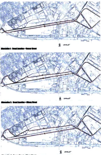
Three alternatives for the Phase 2 BRT route alignments through MIT's campus
are presently being evaluated. The BRT corridor planned through MIT would run
one way, rather than two ways, in three alignment alternatives: the combination
of former Grand Junction right of way and Vassar Street, or the combination of
former Grand Junction right of way and Albany Street, or the combination of
Vassar Street and Albany Street. The Grand Junction alignment would consist of
a 24' wide paved road to the south of the freight rails, which would be relocated
am.. ...
.:b LA&X
Fig 2-6 Diagrams show three alternativesfor the BRT alignment in Urban Ring Phase II
Fig 2-7 Diagram shows one alternative for light rail align-ment in Urban Ring Phase II. This alternative put the light rail at-grade in the Grand Junction Rail Corridor
approximately 10 feet to the north. The City of Cambridge has been working with the MBTA to also include a 12' wide "multi-use path" centered in an 18' wide easement, also in the Grand Junction corridor. The alignments on Vassar Street and Albany Street would run together with other traffic on the streets.
Phase 3: 2011-2016
The Urban Ring rail alignment and stations will be designed and constructed during this phase. The MIS process developed two rail transit alternatives to provide
additional service on the segment of the Urban Ring through MIT campus. According to the completed MIS there are two alternatives for the Phase 3 rail
alignments through the MIT campus. Alternative A places the rail transit totally within a tunnel. Alternative B would be surface light rail in the vicinity of MIT. It would run in the Grand Junction right of way. Both alternatives call for an MIT Station at Mass Ave. There has been discussion of a large joint development project at this station, which would reduce the MBTA's cost of constructing it.
Current planning for the corridor includes the present CSX railroad right-of-way through MIT's campus. The CSX right-of-way is too narrow to accommodate the plans currently included in the MIS; it is the Capital Planning Development Group's assumption that the state will have to acquire land from the Institute to implement their plans.
The Urban Ring project will potentially have both beneficial and adverse impacts for MIT. Transportation will create a more accessible and therefore attractive environment. MIT's campus is currently poorly served by transit. While the East Campus benefits from proximity to the Red Line stop at Kendall Square, the center of the campus has only MBTA buses and the West Campus has almost no access to public transportation. The proposed Urban Ring would dramatically change this situation, essentially connecting the entire campus to all of the main subway lines of Boston. A crucial livability benefit is that people like living close to transit for the convenience. Both internal and external integration of MIT would create a
significantly more attractive and dynamic environment.
However, according to interviews with Deborah Poodry3, MIT has difficulty with the alternative of alignment in Grand Junction. Albany Street is full of MIT laboratories equipped with highly sensitive magnets which cannot tolerate a lot of vibration or electromagnetic interference. The existing freight trains run through MIT's campus in the evening only for ten minutes which does not significantly affect the sensitive machines. MIT would not be able to conduct research near the light rail. The original MIS report was written with the assumption that mitigation could be done for the people that were affected. However, to protect the magnets from the traffic, it would cost MIT one million dollars per machine to move lots of machines. Currently MIT Capital Project Development has been invited to attend working groups and leading committee meetings for the study.
I Deborah Proody is the Director for Capital Project Development.
Fig 2-8 City of Cambridge Zoning Map
CMY OF CAMBRIDGB Zoning MAP
2.2.2 Major Current Trends in the City of Cambridge
An increased amount of development has been undertaken in the past few years in
the old industrial belt that surrounds the MIT campus. In south and east Cambridge
the current urban development trend is to replace former industrial sites with office
or laboratory space usually a part of biotechnology or pharmaceutical industries
or mixed use spaces. There has been a number of adaptive reuse conversions to
biotech buildings in and around Kendall Square, along Albany Street and in the
area between MIT and University Park.
Zoning in Cambridge
The City of Cambridge is divided into a number of districts, each of which is
assigned a specific designation including a variety of residential, office, business,
and industrials zones with several special districts. The divisions of these zones
throughout the city are show below. The Cambridge Zoning ordinance also sets
regulations for development in each zoning district. The regulations include land
use, physical dimensions, required parking areas, and other special considerations.
Zoning overlays are additions or modifications to the Zoning Ordinance applying
to specific areas of the city. Zoning overlays are used to control new development
in some areas. One of the important overlay districts in southeastern Cambridge is
the MIT Institutional Overlay District.
Background
The Cambridge Citywide Growth Management Advisory Committee was formed in 1997 in response to growing community concerns for the future development of Cambridge. This organization has the right to revise the majority of the zoning code to accommodate appropriate quality and density of new development, traffic growth, and affordable housing. The issues that need to be addressed in the re-zoning are: an emphasis on transit-oriented development, housing as a type of development promoted anywhere in the city, non-residential density limitation to reduce traffic impacts, and adjustment of parking requirements for new projects.
There are special zoning ordinances in the original industrial belt. The areas to the north of Main Street are the districts with overlay zones called "Planned Unit Districts" (PUDs) intending to have multiple use zones with office, retail, hotel and residential uses. Additionally, there are areas to the north of Vassar Street called Special Districts with special zoning ordinances, which promote more residential uses. Both of these special regulations intend to integrate existing business and office uses with the Cambridgeport residential fabric.
Transportation in Cambridge
Traffic and transit congestion, parking, and pedestrian safety continue to be significant issues that need to be addressed in Cambridge. Therefore, several projects are being undertaken for improvement of the transportation system.
Fig 2-9 Green Ribbon Report: Top Prioritiesfor Open Space Acquisition
The City of Cambridge has set a goal of reducing single-occupant vehicle trips within and around the city. The Parking and Transportation Demand Management Plan has been developed to achieve this goal. The objective of this plan is to "minimize the amount of parking demand associated with the project." Developers are encouraged to make use of effective measures to reduce the number of single-occupant vehicle trips, so that they can get special consideration during the appeals for the approval of the projects.
Recent Planning in Cambridge
Although there is no overall master plan for the City of Cambridge, the Community Development Department serves planning functions. In fact, it has proposed several documents showing plans for the future of Cambridge. Two of the recent plans important to this study are the Green Ribbon Open Space Committee Report and the Cambridgeport Neighborhood Study.
Green Ribbon Open Space Committee Report
This report intends to develop criteria for expanding and improving the city's open space system. It observes that the larger Central Square area has the least open space per 1000 residents, including Cambrigeport, Area Four, Mid Cambridge and Eastern Riverside. A dilemma facing the city of Cambridge currently is the simultaneously increased demand for open space and decreased availability of land for creating open space. In order to ensure the development of open space, the
... N~i
committee has recommended to the city the following measures: focus funding on priority areas, maintain current open space, improveaccess to open space, andthe like.
Cambridgeport Neighborhood Study
The principal goals identified in this study for the future of Cambridgeport include: maintaining diversity, encouraging interaction between residents in order to enhance the community, promoting safety, and increasing neighborhood involvement in the process of city decisions. One of the important issues addressed in the study is to increase housing for all income levels, especially for middle-income people.
2.2.3 Major Current Trends in MIT's Campus Development
"The goal behind the Institute's construction initiative is to create an infrastructure for invention that fosters the unfettered cross-fertilized of ideas. New facilities will bring together colleagues in related fields, strengthening existing synergies and sparking new ideas for research and teaching."'
Campus Expansion'
MIT's Campus continues to expand. Science and Technology Research and Teaching have the main priority; therefore, everything else is secondary. That is the development mission MIT follows.
' This pharagraph is extracted from the essay on http: //web.mit.edu/evolving.
' This section is written based on the interview with Deborah Poodry and MIT Reports to the President 1997-98.
MIT currently faces a variety of pressures to increase the supply and quality of on-campus and off-campus housing for students, both undergraduate and graduate, faculty, and staff, and these pressures are expected to increase in future. The Institute's need for additional housing resources has been affected by demographic factors such as increased numbers of women students, increased competition for faculty and students, and general changes in the composition of the faculty, staff, and affiliate populations. In short, the Institute is striving to build a campus that will be a source of inspiration and support for the 17,000 members of the MIT
community for generations to come.
The need for providing new and upgraded athletic and recreational facilities continued in an environment of changing expectations and increased competition for faculty, students, and research funding. More recreational space is required for students. Another phase of the sports centre is replacing Rockwell Cage and moving the tennis space. The planning office is at the feasibility stage for a Music/ Theatre labs stage.
MIT needs more space for department use. In addition, MIT administrative staff needs to be located on campus with their own space rather than being located off-campus leased space. Furthermore, there is an infinite demand for research space. Likewise, libraries need investment, because presently too much of the collection is currently located off-campus.
MIT remains focused on the importance of appearance and the quality of MIT's physical environment. With several landscaping projects of Walkways and common spaces planned, the evolving MIT's campus will be redesigned to be unified physically, aesthetically, and socially. Moreover, significant works of art are being commissioned for many of the new buildings. However, these ongoing projects only intensify interconnection within the campus, but do not really connect MIT with its surroundings successfully.
MIT's Involvement in Public and Private Development
"The Cambridge/Boston area is one of the most diverse and culturally rich urban environments in the world, and MIT places a high value on its role within that community.
The Institute works in partnership with city officials to ensure that the relationship between
town and gown is mutually enriching."
MIT's present efforts are directed, in part, toward enhancing the metropolitan experience for those on and off campus. The Institute has been participating in funding public improvement projects to manage traffic congestion, upgrade the infrastructure, and improve the social and aesthetic qualities of the urban landscape. These projects include the work on Vassar Street, overhauling the underground utilities and constructing new landscaping and pedestrian promenades to unify the campus.
The methodology of transforming the existing
boundaries into new transitional boundaries is
interpreted through design exploration, including a
series of analyses of the design project.
3.1 Design Intention
The north boundary of the campus has a serious problem of disconnection between the Institute and the City of Cambridge. The formation of
the back of MIT's campus facing north results from the industrial belt adjacent to the Grand Junction Railroad. For that reason, revitalization
of this area is crucial for future academic expansion and the relationship between the Institute and the City.
3.1.1 Site Location
Based on the design intention, the
area around the historical industrial
belt between MIT's campus and
Cambridgeport is selected as the site
to be investigated.
Fig 3-1 Map of site location. The red line shows the Grand Junction Rail Corridor The blue area is the site to be investigated
3.1.2 Site Implications
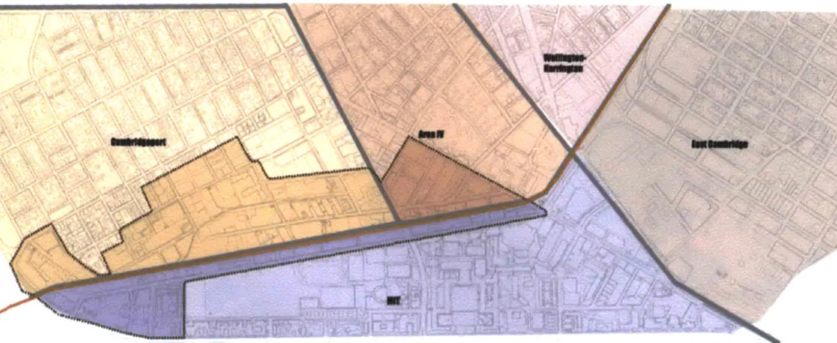
To understand the implication of the site, analyses of the overlapping of the site boundary with neighborhood boundaries, the zoning map, and the land properties map are given as explanations.
Overlapping Boundaries
with Neighborhood
Fig 3-2 Diagram shows the site
over-lapped with neighborhood boundaries: Campbridgeport, Area IV, and MIT
This diagram indicates that the site can be considered as the overlapping of MIT, Cambridgeport andArea IV
Overlapping with Zoning Map
Fig 3-3 Diagram shows the site over-lapped with the zoning map: Special Districts, Industrial District, Residential District.
This diagram implies that the site be-longs to diverse zoning catagories.
Overlapping with Land Properties
Map
Fig 3-4 Diagram shows the site
over-lapped with the land properties map: MIT s Academic Plant, MIT's Invest-ment Property, and other non-MT Properties
This diagram indicates that the site ac-commodates mixed land ownerships.
3.2 Methodology Manifestation
Stratification
Stratified urban elements will be analyzed first. Equally important, the site potentials will be investigated based on the information imported by external forces in order to prepare sufficient information for the next step.
Existing Built-Form
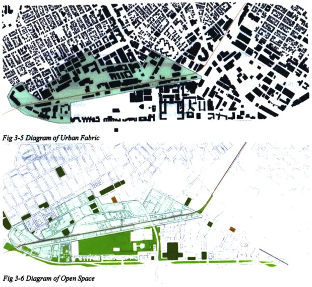
The analysis ofexisting built-form is adeparturepointthattakes into accountthe traces ofthe existing situation ofthe site for urban reconstitution. The tasks include identification of the existing urban elements: urban fabric, street pattern, open space, circulation, land use, and density.
Site Potentials
Potential built-form implied by external forces is explored in relation to the elements of continuity and integration with the context and the possible structure. The tasks involve determination of the projected development, including urban fabric, street pattern, open space,
circulation, land use, and density.
Superimposition
First of all, we obtain all relevant information to determine the design goal and then filter out the information that helps to achieve the invention. In succession, we select the crucial factors determining the invention via overlapping information of site potentials with the crucial external force influence. In addition, we will modify the preconditions that are not in favor of the goal to some degree.
Elaboration of Process
The design process involves the integration of multilayered system of urban form, programming, policy control, human events, and emerging needs as well as their gradual concretization in urban bodies with the aid of guidelines.
Design exploration will follow the steps explained in the following chart.
StraIticaton
Superimpositoon
Creating Transitional Boundaries
(Urban Fabric) (Open Space) (Street Pattern (Circulation) (Land Use) (Density)
infi (Urban Fabric)
-Caul (Open Space)
Reconnect
Reconnect (Street Pattern)
lntegrate(Pedestrian Circulation)
More (Land Use) (Densitye
Infill (Urban Fabric Distinct Patten
createc New Public Realms
Reconnect
Reconnect (Street Patten Station Nexus Integrat (Pdestrian Circulat otation Circulation
More (Land Use) Mare Diverse
Housing
Design Synthesis
Elaboration ot Process
Transit Developement as Urban Redevelopment Catalyst
(Urban Fabric) (Open Space) (Street Pattern) (Circulation) (Land Use) (Density) (Urban Fabric)-(Street Pattern) (Open Space) (Density)-(Land Use) (Circulation) Architectural Visions Blocks (Size, Setback, Orientation, Character
Open Space Streetscape
Circulation (Parkingl Station) Land Use
Density (Height, Parcelization)
3.3 Design Exploration
3.3.1 Stratification
3.3.1.1 Urban Elements
Urban Fabric:
A lot of vacant land
Open Space:
Open space scattered
I JMOMMMO Now
Street Pattern:
Streets disconnected
Pedestrian Circulation:
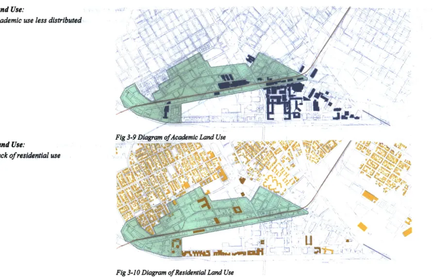
Land Use:
Academic
use less distributed
Nf>~ <
A I
I
.9
)
Land Use:
Lack of residential use
Fig 3-9 Diagmnm ofAca4emic Land Use
Fig 3-10 Diagram of Residential Land Use
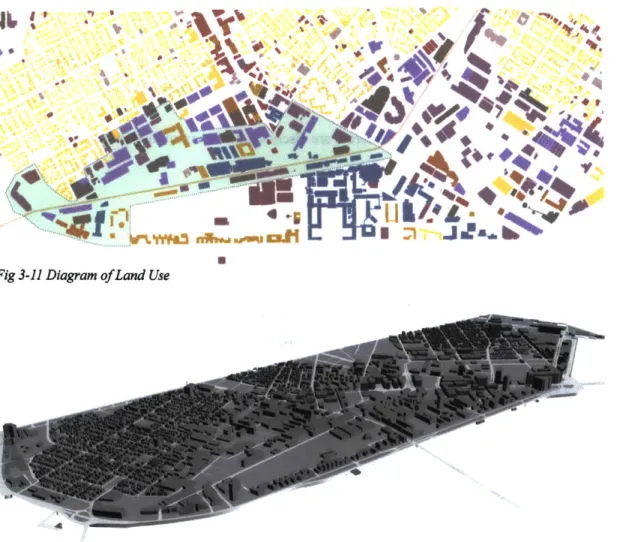
Fig 3-11 Diagram of Land Use
Fig 3-12 Diagram ofDensityz
IL '2
C
Land Use:
Industrial characterDensity:
Low density3.3.1.2 Current Influential Local Forces
The design must have flexibility to accommodate current trends and foreseen circumstances in the future, and also to modify the exterior limitations that will be obstacles for redevelopment.
In the section of stratification, relevant local forces are discussed first to exam their influences on the transformation of existing urban elements.
3.3.1.2.1 Cambridge Community Development
Review of Existing Zoning in the Industrial Belt Special Zoning Ordnances
A large amount of the land in the industrial belt belongs to unique zoning categories. The areas to the north of Vassar Street are zoned as Special Districts, with the goal of integrating existing office and business uses with residential Cambridgeport. Parts of the area fall into the categories of Residence C-3 District, Residence C-3B District, and Industrial B District.
Review of Recent City Planning
Green Ribbon Open Space Committee Report
Based on the analyses from this report, part of Cambridgeport is recommended as a top priority for Community Parks.
Cambridgeport Neighborhood Study
This study made a series of recommendations for the future of Cambridgeport. The recommendations related to this site are summarized below:
e In terms of housing, large scale and mixed-use developments are required in the study area; new developments should complement the existing neighborhoods' characters;
eIn terms of land use and zoning, the area of Putnam Avenue is recommended to be rezoned to support neighborhood business clusters;
eIn terms of urban design, transition between land uses will be emphasized; physical and visual links between important nodes (such as Fort Washington Park) will be strengthened.
3.3.1.2.2 MIT's Campus Development Missions
The design should have flexibility to meet the mission of MIT's campus development.
Academic expansion
MIT needs more space for academic uses, such as administrative space, research space, department space, and libraries. In addition, new and upgraded athletic and recreational facilities are required, and some projects are at the feasibility stage.
More Housing for students,faculty and staff 6
MIT has identified a clear need for significant expansion of the supply of new housing available to serve its graduate students, faculty and staff. The scope of this need suggests a long term program of housing development. Expanding the supply of good quality housing adjacent to MIT's campus will bring significant benefits to the Institute and to the larger Cambridge community with the
6This section is based on Housing Site Inventory-A Physical Planning ContextforAnalysis offHousing Options
emergence of a new off-campus residential environment in Industrial Cambridge.
Partnerships and collaborations
University collaboration with neighbors, local businesses and other institutions is a means for enriching academic and research resources. It allows the university to affect the quality of the greater environment. Joint public, private, and institutional initiatives can reverse the decline of surrounding neighborhoods and also enhance the friendly relationship between the university and its adjacent neighborhoods. The development of campus property for non-university research business can also benefit both of the university and other non-university communities.
3.3.1.3 Site Potentials
Problems with Existing Urban Elements
Vacant Land Unutilized or Underutilized with Industrial Character
The entire industrial belt has taken minimal advantage of its proximity to MIT in terms of its land resource utilization efficiency, mix of uses, urban form character, and amenities. Most of the vacant land is generally used for parking and other automobile-related uses, and older industrial buildings in poor condition. There is little open space with good quality and convenient accessibility.
Broken Environment
Clearly, the area lacks a center, and a set of well-organized open space networks. The extensive MIT landholdings are divided by the Grand Junction rail corridor. This has significantly split contiguous parcels, thereby reducing the land development potential and ability to generate