HAL Id: hal-01174792
https://hal-brgm.archives-ouvertes.fr/hal-01174792
Submitted on 26 Mar 2021
HAL is a multi-disciplinary open access
archive for the deposit and dissemination of
sci-entific research documents, whether they are
pub-lished or not. The documents may come from
teaching and research institutions in France or
abroad, or from public or private research centers.
L’archive ouverte pluridisciplinaire HAL, est
destinée au dépôt et à la diffusion de documents
scientifiques de niveau recherche, publiés ou non,
émanant des établissements d’enseignement et de
recherche français ou étrangers, des laboratoires
publics ou privés.
systems: Insights from rift domain mapping in the Bay
of Biscay-Pyrenees
J. Tugend, G. Manatschal, N. J. Kusznir, E. Masini, G. Mohn, Isabelle Thinon
To cite this version:
J. Tugend, G. Manatschal, N. J. Kusznir, E. Masini, G. Mohn, et al.. Formation and deformation
of hyperextended rift systems: Insights from rift domain mapping in the Bay of Biscay-Pyrenees.
Tectonics, American Geophysical Union (AGU), 2014, 33 (7), pp.1239-1276. �10.1002/2014TC003529�.
�hal-01174792�
Formation and deformation of hyperextended rift
systems: Insights from rift domain mapping
in the Bay of Biscay-Pyrenees
J. Tugend1, G. Manatschal1, N. J. Kusznir2, E. Masini1, G. Mohn3, and I. Thinon4
1
Institut de Physique du Globe de Strasbourg-EOST, Université de Strasbourg-CNRS, Strasbourg, France,2Department of Earth and Ocean Sciences, University of Liverpool, Liverpool, UK,3Département Géosciences et Environnement, Université
de Cergy-Pontoise, Cergy, France,4BRGM, Orléans, France
Abstract
The Bay of Biscay and the Pyrenees correspond to a Lower Cretaceous rift system including both oceanic and hyperextended rift domains. The transition from preserved oceanic and rift domains in the West to their complete inversion in the East enables us to study the progressive reactivation of a hyperextended rift system. We use seismic interpretation, gravity inversion, andfield mapping to identify and map former rift domains and their subsequent reactivation. We propose a new map and sections across the system illustrating the progressive integration of the rift domains into the orogen. This study aims to provide insights on the formation of hyperextended rift systems and discuss their role during reactivation. Two spatially and temporally distinct rift systems can be distinguished: the Bay of Biscay-Parentis and the Pyrenean-Basque-Cantabrian rifts. While the offshore Bay of Biscay represent a former mature oceanic domain, the fossil remnants of hyperextended domains preserved onshore in the Pyrenean-Cantabrian orogen record distributed extensional deformation partitioned between strongly segmented rift basins. Reactivation initiated in the exhumed mantle domain before it affected the hyperthinned domain. Both domains accommodated most of the shortening. Thefinal architecture of the orogen is acquired once the conjugate necking domains became involved in collisional processes. The complex 3-D architecture of the initial rift system may partly explain the heterogeneous reactivation of the overall system. These results have important implications for the formation and reactivation of hyperextended rift systems and for the restoration of the Bay of Biscay and Pyrenean domains.1. Introduction
The description of repeated opening and closing of oceanic basins also referred to as the“Wilson Cycle” [Wilson, 1966] represents one of the main achievements of the plate tectonic theory. Plate tectonic cycle evolution suggests that mountain belts build on the former site of conjugate rifted margins and intervening oceanic domains. Therefore, the understanding of the formation and deformation of rift systems is critical to further understand plate tectonics. Over the past decades, the development of high-resolution long-offset seismic reflection data improved the imaging of the crustal architecture of rifted continental margins. These geophysical data combined with drill hole observations show that many rifted continental margins are formed by hyperextended domains consisting in extremely thinned continental crust and/or exhumed subcontinental mantle (e.g., Iberian margin: Boillot et al. [1987] and Péron-Pinvidic and Manatschal [2009]; Exmouth plateau: Driscoll and Karner [1998]; West African margin: Contrucci et al. [2004], Aslanian et al. [2009], and Unternehr et al. [2010]; mid-Norwegian margin: Osmundsen and Ebbing [2008]; and Australian and Antarctica margins: Espurt et al. [2012]). In the meantime, on land studies in mountain belts showed that remnants of hyperextended domains could also be identified in internal parts of collisional orogens (e.g., Alps: Lemoine et al. [1987], Manatschal [2004], Mohn et al. [2010], Masini et al. [2012], and Beltrando et al. [2014]; Pyrenees: Lagabrielle and Bodinier [2008], Jammes et al. [2009], Lagabrielle et al. [2010], Clerc et al. [2012, 2013], and Masini et al. [2014]; and Caledonides: Andersen et al. [2012]). In spite of these discoveries, most studies on the formation of collisional orogens have not yet integrated the complexity of the precollisional rift architecture. The implications of the former rift-related thinning and the role of rift inheritance are progressively being further investigated [e.g., Roca et al., 2011; Jammes et al., 2014; Mohn et al., 2014].
In this study, we focus on the Bay of Biscay and the Pyrenees, one of the rare examples where both the formation and progressive reactivation of rifted margins can be investigated in one and the same system.
Tectonics
RESEARCH ARTICLE
10.1002/2014TC003529
Key Points:
• Three-dimensional rift architecture depends on the prerift structuration of the lithosphere
• The rift systems presented are strongly segmented both offshore and onshore
• The formation of the Pyrenean orogen is controlled by rift domain inheritance
Correspondence to:
J. Tugend, [email protected]
Citation:
Tugend, J., G. Manatschal, N. J. Kusznir, E. Masini, G. Mohn, and I. Thinon (2014), Formation and deformation of hyperex-tended rift systems: Insights from rift domain mapping in the Bay of Biscay-Pyrenees, Tectonics, 33, 1239–1276, doi:10.1002/2014TC003529. Received 10 JAN 2014 Accepted 6 JUN 2014
Accepted article online 24 JUN 2014 Published online 3 JUL 2014
This area corresponds to a polyphased Triassic to Early Cretaceous rift system leading to the formation of hyperextended basins and ultimately oceanic crust in the western Bay of Biscay [e.g., Vergés and García-Senz, 2001, and references therein]. The Late Cretaceous to Cenozoic convergence between the European and Iberian plates led to the heterogeneous deformation of the rift system, illustrated by changes in compressional architecture along strike [e.g., Muñoz, 2002]. Reactivation was relatively moderate along the southern Cantabrian margin [e.g., Pulgar et al., 1996; Gallastegui et al., 2002; Roca et al., 2011]. In contrast, the former hyperextended rift basins from the Pyrenean-Cantabrian domain (e.g., the Mauléon and Basque-Cantabrian basins [Pedreira et al., 2007; Jammes et al., 2009; Lagabrielle et al., 2010; Roca et al., 2011]) are completely inverted and integrated into the orogenic system. At present, the compressional units characterizing the Pyrenean orogen are well known [e.g., Mattauer, 1968; Choukroune and Séguret, 1973; Mattauer and Henry, 1974; Choukroune, 1992]. In contrast, the rift-related paleogeographic domains remain poorly or only locally defined and their architecture is mainly described on 2-D sections [e.g., Jammes et al., 2009; Lagabrielle et al., 2010; Masini et al., 2014]. A well-defined and uniform definition of precompressional rift domains across the overall system is still missing. This results in controversial interpretations of the continuity of some precompressional structures and of their role during the rifting episode (e.g., the North Pyrenean fault [Mattauer and Séguret, 1971; Canérot et al., 2001; Canérot, 2008]). The aim of this work is twofold (1) to illustrate the complex 3-D evolution of strain partitioning and architecture within hyperextended rift systems and (2) to investigate the progressive role of rift inheritance from the initiation of reactivation to continental collision. We apply for thefirst time a new multidisciplinary approach designed by Tugend et al. [2014] to characterize and identify diagnostic elements defining similar rift domains in offshore and onshore settings. We combine gravity inversion results and seismic interpretations withfield observations to propose a new map of rift domains from the offshore Bay of Biscay to their onshore fossil equivalents preserved in the Pyrenean orogen.
The mapping approach used in our study may be used in other orogenic systems and may bring new insights on the interpretation of the architecture of collisional orogens as well as on the restoration of the spatial and temporal evolution of fossil rift systems.
2. Geological Framework
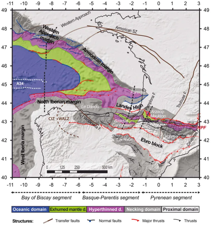
The Bay of Biscay corresponds to a V-shaped oceanic basin opened westward toward the Atlantic Ocean. Located between the European and Iberian plates, it is bordered to the North by the Western Approach and Armorican margins and to the South by the North Iberian margin (Figure 1). The eastern termination is characterized by several Mesozoic rift basins recording geophysical and/or geological evidence for extreme crustal thinning both offshore (e.g., the Parentis basin: Pinet et al. [1987], Bois and Gariel [1994], Tomassino and Marillier [1997], and Jammes et al. [2010a, 2010c]) and onshore (e.g., the Aulus basin: Lagabrielle and Bodinier [2008], Lagabrielle et al. [2010], and Clerc et al. [2012]; the Arzacq-Mauléon basin: Daignières et al. [1994], Jammes et al. [2009], Lagabrielle et al. [2010], Debroas et al. [2010], and Masini et al. [2014]; and the Basque-Cantabrian basin: Pedreira et al. [2007] and Roca et al. [2011]).
2.1. Tectonic and Sedimentary Evolution of the Bay of Biscay and Pyrenean Domains
The Bay of Biscay and Pyrenean domains represent a strongly structured region that is the result of consecutive extensive and compressive tectonic cycles that initiated in the early Palaeozoic. The formation of the Variscan orogen during the Carboniferous resulted from the collision of the Laurussia and Gondwana continental margins with intervening oceanic domains and microcontinents such as Armorica (for a review, see Matte [1991, 2001]). The post-Variscan evolution is related to the emplacement of strike-slip or transform faults throughout the Late Carboniferous to the Early Permian (e.g., Toulouse fault, Cévennes fault, Ventaniella fault, and North Pyrenean fault) that strongly structured the lithosphere. Two main scenarios have been proposed for this post-Variscan evolution: one that includes a compressional episode independent of Variscan tectonics [Arthaud and Matte, 1975, 1977] and a second that proposes an extensional to transtensional phase related to the postorogenic collapse of the chain [Burg et al., 1994a, 1994b]. The following Triassic to Jurassic rift events resulted in the formation of intracontinental basins bounded by NE-SW trending normal faults that may partly reactivate Palaeozoic structures (e.g., Aquitaine basin: Curnelle et al. [1982]). They arefilled by thick sequences of Triassic siliciclastics, carbonates, and evaporites
(Germanic Facies: Curnelle [1983] and Fréchengues [1993]). Deposits belonging to the Keuper formation are associated with tholeitic magmatism [e.g., Montadert and Winnock, 1971; Winnock, 1971; Rossi et al., 2003]. The latest Triassic and Jurassic marine transgression led to the formation of a carbonate platform whose lateral extent is poorly constrained.
A major change occurred in the Late Jurassic to Early Cretaceous, related to the northward propagation of the Atlantic rift. The deposition of marine sediments in the Western Bay of Biscay is contemporaneous with the E-W reorganization of the depocenters in the present-day Arzacq, Tarbes, and Parentis basins [Bureau de Recherches Géologiques et Minières (BRGM) et al., 1974; Biteau et al., 2006]. Extreme crustal thinning in the Bay of Biscay resulted in continental breakup and seafloor spreading initiation during latest Aptian to early Albian time [e.g., Montadert et al., 1979; Boillot, 1984]. At this stage, crustal and mantle exhumation in onshore rift basins (e.g., Basque-Cantabrian and Arzacq-Mauléon basins: Jammes et al. [2009], Lagabrielle et al. [2010], and Roca et al. [2011]) is related to an acceleration of subsidence. This event is recorded by the deposition of deep marine sediments [Ducasse and Velasque, 1988]. It is accompanied by alkaline magmatism (including intrusions and volcanic products) from late Aptian to early Santonian time (~113 to 85 Ma [Lamolda et al., 1983; Montigny et al., 1986]). Onset of compressional deformation is recorded in Santonian sediments by a regional unconformity [Garrido-Megías and Ríos, 1972; McClay et al., 2004] and a weak reactivation in the Northern Bay of Biscay [Thinon et al., 2001]. The major collision phase was reached during the Eocene and continued until the end of the Oligocene [Muñoz, 2002; Vergés et al., 2002] with the generalized uplift of the chain and formation of foreland basins. Because this paper is mainly focused on the formation and reactivation of hyperextended basins, we will subdivide the sedimentary deposits into prehyperextension, synhyperextension, and posthyperextension and syncompressional to postcompressional sequences.
2.2. A Controversial Late Jurassic to Early Cretaceous Plate Kinematic Context
At present, there is no consensus on the Late Jurassic to Early Cretaceous kinematic evolution leading to the formation of the Bay of Biscay. Opening in a back-arc setting is proposed by Sibuet et al. [2004] and Vissers
Figure 1. Bathymetric map of the Bay of Biscay and Pyrenees showing the major tectonic structures and the main Mesozoic basins. Magnetic anomalies are based on Sibuet et al. [2004].
and Meijer [2012]. Other hypotheses suggest that left-lateral strike-slip to transtensional deformation was accommodated along the North Pyrenean fault or within pull-apart basins [e.g., Le Pichon et al., 1971; Mattauer and Séguret, 1971; Choukroune and Mattauer, 1978].
Most of the plate kinematic models proposed previously rely on the identification and restoration of magnetic anomalies of the M-series in the North Atlantic between Iberia and Newfoundland [e.g., Olivet, 1996; Srivastava et al., 2000; Sibuet et al., 2004]. These restorations assume minor prebreakup movements. This hypothesis is questioned by the discovery of hyperextended domains that can be mapped over hundreds of kilometers continentward of thefirst unambiguous magnetic anomaly related to breakup (Tucholke et al. [2007] or Péron-Pinvidic and Manatschal [2009]). Controversies also arise from the interpretation of the age and nature of magnetic anomalies in the Bay of Biscay and the southern North Atlantic in general. The M-series (M3–M0, 126 to 118.5 Ma) identified in the Iberia-Newfoundland and Bay of Biscay margins [e.g., Sibuet et al., 2004] have been reinterpreted as either related to mantle exhumation [Sibuet et al., 2007] or magmatic underplating [Bronner et al., 2011, and references therein]. Therefore, these anomalies do not necessarily represent isochrons. This justifies a revision of existing plate kinematic models depending on the restoration of the M-series magnetic anomalies (see Bronner et al. [2011, 2012] and Tucholke and Sibuet [2012]). Based on these new discoveries combined withfield observations, new plate kinematic scenarios were proposed. Some authors suggested that the left-lateral displacement of the Iberian plate was already initiated in the Late Jurassic, resulting in a transtensional setting along the European and Iberian plates [e.g., Wortmann et al., 2001; Schettino and Scotese, 2002; Canérot, 2008; Jammes et al., 2009, 2010a]. Indirect evidence for this pre-Aptian movement comes from the thick Late Jurassic to Early Cretaceous sedimentary sequences in the Parentis and Cameros basins [e.g., Salas and Casas, 1993; Mas et al., 1993; Jammes et al., 2010a]. A major break occurred in Aptian time [Olivet, 1996] as a result of the counterclockwise rotation of Iberia [Gong et al., 2008; Jammes et al., 2009, 2010a]. As a consequence of this rotation, a NNE-SSW to NE-SW extension is initiated in rift basins preserved onshore [Jammes et al., 2009; Lagabrielle et al., 2010; Roca et al., 2011; Tavani, 2012] as emphasized by the NE-SW segmentation observed (e.g., Pamplona, Toulouse, and Cevennes faults). These NE-SW transfer faults cross the Iberian-European plate boundary and are locally sealed by Albian sediments (Pamplona fault, between the Basque-Cantabrian and Arzacq-Mauléon basins [Razin, 1989; Claude, 1990]). In this paper, we will show that the complex polyphased history strongly influenced the 3-D architecture of the Bay of Biscay-Parentis and Pyrenean-Basque-Cantabrian rift systems.
2.3. Pyrenean Reactivation and Shortening Estimations
The palaeogeographic evolution of the Bay of Biscay and Iberia-Newfoundland rifted margins is relatively well constrained after the quiet magnetic period of the Cretaceous and the identification of the magnetic anomaly 34 (83 Ma, Santonian) [e.g., Roest and Srivastava, 1991; Rosenbaum et al., 2002]. The northward movement of the African plate during the Late Cretaceous resulted in the initiation of compression in the Bay of Biscay and the Pyrenees. Although the shortening direction is reasonably coherent between different kinematic models (N-S to NE-SW, respectively, [Roest and Srivastava, 1991; Rosenbaum et al., 2002]), the total amount of Late Cretaceous relative to Cenozoic shortening is still a matter of debate. At the scale of the Bay of Biscay and Pyrenean-Cantabrian orogen, the transition from embryonic subduction in the North Iberian margin to continental collision in the Pyrenees is interpreted to have resulted from an increase in convergence from west to east. Based on the restoration of magnetic anomalies, Rosenbaum et al. [2002] estimated about 144 km of shortening in the Western Pyrenees as compared to 206 km in the Eastern Pyrenees. Classical palinspastic restorations of sections across the Pyrenees have usually been based on restorations of the thick-skin deformation observed in the Axial zone [e.g., Teixell, 1998; Muñoz, 2002]. This approach underestimates the shortening related to the reactivation of hyperextended domains. It is therefore unable to decipher the overall amount of convergence accommodated in the Pyrenean domain.
3. Mapping Hyperextended Domains: Combining Onshore
and Offshore Observations
3.1. Hyperextended Rift Domains: Terminology and Identification
In spite of variable magmatic, structural, and sedimentary evolution that in turn depend on the amount and rates of extension, thermal history, and inheritance, most magma-poor rifted margins share comparable
large-scale architectures [Reston, 2009; Péron-Pinvidic et al., 2013]. Usingfirst-order geological and/or geophysical observations, distinctive structural rift domains can be identified. From continent to ocean, the following domains can be distinguished: the proximal, necking, hyperthinned, exhumed mantle, and oceanic domains (Figure 2, see also Figure 1 in Tugend et al. [2014] for comparison with alternative classifications). Extensional deformation related to the formation of these domains is polyphased, progressively localizing toward the location offinal breakup [e.g., Péron-Pinvidic and Manatschal, 2009; Sutra et al., 2013]. Therefore, these domains reflect successive steps in the formation of magma-poor rifted margins, suggesting that they may also correspond to genetic domains.
We use the approach developed by Tugend et al. [2014] to enable the characterization and identification of comparable rift domains in present-day magma-poor rifted margins and their fossil analogues preserved in collisional orogens (Figure 2). This approach and its related results are summarized hereafter. Offshore, quantitative techniques provide estimations of accommodation space, crustal thickness, and lithosphere thinning while seismic interpretation enables the recognition of extensional settings (low- and high-β settings [Wilson et al., 2001]). Onshore, the identification relies on the description of key outcrops preserving the nature of sediments, basement rocks, and of their interface. This geological/geophysical approach can be further used as an interface between onshore and offshore observations and to suggest analogies. Offshore seismic interpretations can take advantage of onshore observations regarding the nature of sediment, basement, and of their interface. The large-scale geometry and stratigraphic architecture imaged offshore can be used to restore onshore fossil remnants back into a rifted margin context (Figure 2).
This combined approach is applied for thefirst time to map the overall rift system from the offshore Bay of Biscay to its onshore fossil analogues preserved in the Pyrenees (including the Basque-Cantabrian basin). Interpretations of structural domains along offshore seismic reflection profiles are combined with mapping of crustal thickness, lithosphere thinning, and Moho depth using gravity inversion. Onshore mapping relies on the identification of remnants of the rift system preserved within well-defined compressive tectonic units.
3.2. Onshore: Mapping Remnants of the Rift System
The mapping of rift domains in onshore deformed analogues depends on the ability to decipher the deformation and sedimentary history. The definition of compressive units is based on the identification of first-order compressive structures corresponding to the first generation of thrusts. These coherent tectonic units are usually bounded by major thrust contacts but are often only weakly deformed internally. The methodology used to map rift domains onshore is here exemplified by the example of the Arzacq-Mauléon basin. A summary of main observations is given below and summarized in Figure 3 (detailed descriptions of field observations in Jammes et al. [2009] and Tugend et al. [2014]).
3.2.1. Defining Coherent Tectonic Units: History of Compressional Deformation
In the Arzacq-Mauléon basin, different phases of deformation can be identified resulting in two opposite directions of thrusting. The shortening related to the initiation of Pyrenean compression is accommodated by Late Cretaceous, south-directed thrust systems (e.g., Sarrance, Mail Arrouy, or Lakoura thrust systems [Casteras et al., 1970a, 1970b, 1970c; Teixell, 1998]; Figures 2 and 3). This initial sampling of the distal parts of the former rift system is locally overprinted by a second phase of deformation resulting in north-directed thrusts (e.g., the Saint Palais, Sainte Suzanne, and Ossau thrusts [Canérot et al., 2001]) and south-directed backthrusting in the Axial zone (e.g., Gavarnie and Guarga thrust systems [Teixell, 1998]). As a result of this structural analysis, several tectonic units can be defined within the Arzacq-Mauléon basin (Figure 2). Within each unit, key outcrops preserving primary contacts between basement and the prehyperextensional, synhyperextensional, and posthyperextensional sediments can be found [e.g., Canérot, 2008; Jammes et al., 2009; Lagabrielle et al., 2010; Debroas et al., 2010; Masini et al., 2014].
3.2.2. Outcrops Preserving Remnants of the Former Rift System
Remnants of rift domains can be defined in the Arzacq-Mauléon basin from South to North (Figures 2 and 3, see also Tugend et al. [2014]).
In the axial zone (southernmost external Pyrenean unit)—former proximal rift domain, upper crustal rocks from the basement are eroded and directly onlapped by shallow marine posthyperextensional sediments (Figure 3) suggesting no or only a weak rift-related thinning.
F igur e 2 . Phi losoph y o f the onsh ore/offshore approach appli ed in this stud y. Left side : synth etic diag ram com bining geop hy sical (u pper par t) and geolog ical (lower par t) diagn ostic ele ments of stru ct ura l/geneti c ri ft do mains a t cont inental rif te d ma rgins (af te r Tugend et al .[ 2014]). The termi nolo gy u sed in th is stud y is indi cate d in the centr al p a rt .Right sid e :t his a pp ro ach is u sed to m ap rifted d o m a ins o ffsho re (gravi ty inversi o n resu lts and se ismi c int e rpr e ta ti ons) and o nshore (str uc tu ral m ap o f the M aul é on ba sin a nd o f the sou ther np a rt o f th e A rz a cq b a si na n d fie ld o b se rva ti o n s) .
F igure 3. (a ) G eo lo g ica lm ap of the M aul é on ba si n a nd the S ou thern p ar t o f the A rzac q b a sin. Li tholo g ies a nd a g e o f seq uences are syntheti zed in a log. (b) Fi eld p h oto g rap h s o f th e m a in ob ser v atio ns .K a: K a lkuet ta canyon, contact b etween the “Calcair e s d es Cañons ” platform and u nderl y in g e ro de d P al aeo zo ic b a se m ent (0°50 ′59, 7 2″ W/42° 59 ′17, 3 1″ N ). M e: Mendi b el za massi f, te ct o n o -s e d im e n ta ry b re cc ia at the contac t with the to p b a seme nt deta chm e nt fa ult (1°6 ′55 ,78 ″W/43 °5 ′40, 1 6″ N ). A r: Ab arrat ia q uarry, d efor mati on of the g ra nul itic b a se m ent (go uges and cat acl a stic ove rpri n t) char ac ter ing the to p b a se m en t d et a chm e n t fau lt d e sc ri b e d b y Jamm es et al. [2009 ] (1° 14 ′17,6 9″ W/43° 20 ′55, 6 4″ N ). U r: Urda ch qua rry, synri ft b recci a rew ork ing mantle and b asement roc ks (0°4 0′ 39,62 ″W/ 43°7 ′10 ,9 1″ N). (c) S impli fi e d car to ons o f the key o bser vatio n s fr o m remnant s of the fo rme r rift syst e m p reser v ed in the P yre n ean n ap pe stack. A xial zo n e u n it: rem n ant o f the p roxi mal d o m ai n. Bed ous-M e n d ib e lz a u nit: remnan t o f the Nec k ing d omain. Lay e ns-L abourd un it :r e m na n t o f th e h yp e rth in n e d d omain. Sarranc e -M a il arrouy unit: remnant of the e xhumed mantle do main. G rand Rieu Hig h :r emnant of th e hy per th inn e d d omain. Arzacq basin: transition fro m p rox imal to n ec k ing domain. T he map is simpli fi ed af ter the BRGM (1/50, 0 00) geol ogic al m a p o f: Ar thez d e Bé arn [Dubreuilh a n d K arn a y, 1997], A rgelès-Ga zos t [Tern et ,1 980 ], G a varn ie [Ma jesté-M enjoulàs a nd Debon ,1 999 ], H a sp arren [Burger et al ., 197 2], Iholdy [Boissonnas et a l., 197 4], Larun s-Sompor t [Terne t et al ., 2 004 b], Larrau [Caster as et a l., 1 970c ], Lour des [Ca ster as et al ., 197 0b], Oloron-Sain te -Marie [Caster as et al ., 197 0a], O rt h ez [Hen ry et a l., 1 989 ], Mauléon -Lich arre [Bol tenh a ge n et a l., 197 6], M orlaàs [Delf aud et al ., 19 82], P au [Bureau d e Recherches Géol ogi q ues et M in ières ,1 9 6 3 ], S a in t-Je a n -P ie d -d e-P o rt [Le Po chat et al ., 19 78], a nd Ta rdets [Caster as et al ., 1 971 ].
In the Bedous-Mendibelza unit—former necking domain, the exhumed basement of the Mendibelza and Igounze massifs [Johnson and Hall, 1989a, 1989b; Miranda-Aviles et al., 2005; Masini et al., 2014] is onlapped by synhyperextension sequences progressively thickening and deepening northward. This domain marks a progressive transition from shallow to deep water sediments (conglomerates from the Mendibelza formation, passing laterally to turbidites and marls) as a consequence of the initiation of crustal thinning. In the Layens-Labourd unit—former hyperthinned domain, granulites derived from the prehyperextension middle crust [Vielzeuf, 1984] are exhumed in the Labourd massif [Jammes et al., 2009]. They are onlapped by
Figure 4. Raw data used for the gravity inversion. (a) Bathymetry and topography [Smith and Sandwell, 1997], (b) free-air gravity [Sandwell and Smith, 2009], and (c) oceanic age isochrones [Müller et al., 1997]. (d) Sediment thickness is derived from offshore seismic interpretations (raw seismic lines from the Norgasis survey: Thinon [1999] and Avedik et al. [1993, 1996]; ECORS Bay of Biscay: Pinet et al. [1987] and Bois and Gariel [1994]; IAM 12 and ESCIN 4 seismic lines: Gallart et al. [2004], Gallastegui et al. [2002], and Banda et al. [1995]) and the depth to basement map of the Aquitaine basin from Serrano et al. [2006].
late synhyperextension to posthyperextension sediments containing reworked pieces of exhumed granulite (Bonloc breccias [Claude, 1990]). Observations from this domain indicate that at least locally, the whole upper crust had been removed and consequently the crust had to be thinned.
In the Sarrance-Mail Arrouy unit (internal orogenic unit)—former exhumed mantle domain, synhyperextension sediments are more than 4 km thick near the city of Mauléon [Roux, 1983; Fixari, 1984; Souquet et al., 1985]. Numerous outcrops of mantle rocks are observed that are associated to thin slices of continental crust [Duée et al., 1984; Fortané et al., 1986; Lagabrielle et al., 2010; Debroas et al., 2010]. Mantle rocks are also
Figure 5. (a) Moho depth, (b) crustal thickness, (c) residual continental crust, and (d) continental lithosphere thinning factor maps resulting from gravity inversion. The limits of rifted domains determined from seismic interpretations are also indicated.
reworked in Cenomanian breccias indicating that at least locally, mantle rocks had to be exhumed at the seafloor (Figure 3; e.g., Urdach breccias: Jammes et al. [2009], Lagabrielle et al. [2010], Debroas et al. [2010], and Masini et al. [2014]).
In the Grand Rieu high unit—former hyperthinned domain, a thick posthyperextension sequence may directly onlap onto basement as indicated by the Cardesse 2 drill hole (location Figure 3 [BRGM et al., 1974; Serrano et al., 2006]). This local observation may reflect a large sedimentary aggradation consecutive to posthyperextension thermal subsidence in a former hyperthinned domain (Figure 2).
In the Arzacq basin—former proximal to necking domain, the progressive thinning of the continental crust (from about 25 km to the north to about 20 km below the Grand Rieu high [Daignières et al., 1982, 1994]) is concomitant with a southward thickening of synhyperextension sequences [Biteau et al., 2006]. This progressive creation of accommodation space may indicate the progressive transition from a proximal to a necking domain (from north to south).
The mapping of former rift domains onshore relies on the exposed surface observations (here locally supported by drill hole data) and reflects the integration of the former rift into the orogenic system.
3.3. Offshore: Seismic Interpretations and Gravity Inversion Mapping
Gravity inversion results have already been used to characterize and identify structural domains on 2-D sections at rifted continental margins (Figure 2 [Tugend et al., 2014]). In this paper, the aim is to associate this technique with local seismic interpretations to map and unravel the spatial evolution of structural/ genetic rift domains from the offshore Bay of Biscay to the onshore Mesozoic Arzacq basin buried under posthyperextension sediments and the thick syncompressional sequences of the Tertiary Aquitaine basin.
3.3.1. Gravity Inversion: Scheme and Data Sets
Gravity inversion was based on public domain data (Figure 4): free-air gravity [Sandwell and Smith, 2009], bathymetry [Smith and Sandwell, 1997], and oceanic isochrons [Müller et al., 1997]. Information on sedimentary thickness comes from a compilation of offshore seismic interpretations combined with the depth to basement map of the Aquitaine basin from Serrano et al. [2006] (Figure 4). Seismic reflection data were derived from different surveys: the Norgasis survey [Avedik et al., 1993, 1996; Thinon, 1999], the ECORS Bay of Biscay section [Pinet et al., 1987; Bois and Gariel, 1994], the IAM 12, and the ESCIN 4 seismic lines [e.g., Banda et al., 1995; Gallastegui et al., 2002; Gallart et al., 2004].
Moho depth, crustal thickness, continental lithosphere thinning factor, and residual continental crust maps (Figure 5) were produced by gravity inversion. This technique includes a thermal gravity anomaly correction and a parameterization of decompression melting to predict volcanic additions (detailed scheme described by Greenhalgh and Kusznir [2007], Chappell and Kusznir [2008a], Alvey et al. [2008], and Cowie and Kusznir [2013]; parameters for this study are presented in Table 1). A compaction-controlled density-depth relationship is applied to sedimentary sequences [Chappell and Kusznir, 2008b].
3.3.2. Three-Dimensional Mapping Derived From Gravity Inversion and Seismic Interpretations
The maps resulting from gravity inversion presented in Figure 5 were computed assuming a“normal” volcanic addition (corresponding to a standard oceanic crust thickness of about 7 km [White et al., 1992]). This solution assumes the occurrence of decompression melting during rifting once the lithosphere is thinned below a critical value (γ = 0.7; Table 1), producing magmatic additions to the extended continental crust. In the case of a magma-poor rifted margin as proposed for the Bay of Biscay [e.g., De Charpal et al., 1978; Montadert et al., 1979; Avedik et al., 1982; Le Pichon and Barbier, 1987; Thinon et al., 2003], the transition zone between unequivocal oceanic and continental crusts may be interpreted as exhumed mantle (Figure 2). The characterization of structural domains on 2-D sections (Figure 2) partly relies on diagnostic elements
Table 1. Parameters Used for Gravity Inversion
Parameters Value and Reference Data Set
Critical thinning factor (γ) 0.7
Reference crustal thickness 40 km
Breakup age 110 Ma
determined from gravity inversion results [Tugend et al., 2014]. The combined analysis of Moho depth, crustal thickness, and lithosphere thinning maps (Figure 4) can be further used to delimit offshore structural domains and identify their evolution in 3-D.
The proximal domain presents relatively constant and limited values of crustal and lithosphere thinning (Figure 5d) and a smooth Moho topography (Figure 5a). The rapid increase in lithospheric thinning values coincides with a Moho rise delimiting the proximal from the necking domain (Figure 5a/5d). The transition from the necking to hyperthinned domain can be identified on seismic sections (Figure 2; e.g., Sutra et al. [2013]) and corresponds in this example to thinning values between 0.5 and 0.6 and crustal thicknesses of about 10 to 15 km (Figure 5b/5c). The beginning of the exhumed mantle domain can be interpreted at afirst order at the termination of the continental crust (Figure 5c). Moho topography derived from gravity inversion [Greenhalgh and Kusznir, 2007; Chappell and Kusznir, 2008a; Alvey et al., 2008] is slightly curved through this domain enabling the shallowest Moho depth to be reached (Figure 5a). Gravity inversion provides indirect observations compatible with the existence of an exhumed mantle domain in the Bay of Biscay. This hypothesis is further supported by reflection and refraction seismic interpretations [e.g., Fernández-Viejo et al., 1998; Thinon et al., 2003; Ruiz, 2007] and by analogy with the existence of such a domain onshore (Arzacq-Mauléon; Figure 3). The oceanic domain is marked by a deepening of the Moho (Figure 5a) and a thickening of the crust at the oceanward edge of the exhumed mantle domain (Figure 5b). Residual patches of thicker crust are observed within the oceanic domain (Figure 5c/5d) and can be interpreted as a locally overthickened oceanic crust (in comparison with the 7 km thick volcanic addition used for gravity inversion; Table 1).
The resulting maps show the present-day distribution of oceanic and continental crust as well as a possible extent of exhumed mantle in the Bay of Biscay. In areas that underwent reactivation and crustal thickening during compression (e.g., the North Iberian margin), these maps need to be interpreted carefully and are further constrained by seismic interpretations. Onshore, in the Western Pyrenees, the former rift-related thinning of the northern Arzacq basin can still be deduced from lithosphere thinning and crustal thickness maps (Figure 5).
4. Map of the Bay of Biscay-Pyrenean Rift System
Offshore and onshore observations are combined to recognize, describe, and map structural/genetic rift domains and their compressional overprint from the Bay of Biscay to the Pyrenean-Cantabrian orogen (Figure 6). We apply the terminology and geological/geophysical approach described in the previous section and synthetized in Figure 2 (see also Tugend et al. [2014]).
4.1. Definition of Rift Domains 4.1.1. Proximal Domain
Proximal domains are characterized by only weak to no rift-related lithosphere and crustal thinning (Figure 5). Creation of accommodation space is restricted to graben and half-graben basins characterizing low-β extensional systems (Figure 2). The sedimentary record of this domain may include subaerial exposure, continental to shallow water sedimentary systems, and no or minor aggradation of postrift sequences (Figures 2 and 3).
Offshore, this domain corresponds to the continental shelves (e.g., the Armorican platform, the western part of the North Iberian shelf, near Ortegal Spur, and Landes high; Figure 6). Onshore, it can be mapped in external parts of the orogen and may be partly buried below Tertiary foreland basins such as the Duero basin (south of the Basque-Cantabrian orogen), the Jaca and Ebro basins south of the Pyrenees, or in the northern part of the Aquitaine basin (Figure 6).
4.1.2. Necking Domain
Lithosphere and crustal thinning are initiated in the necking domain (Figure 5). The oceanward increasing accommodation space and deepening of the top basement coincides with the ascending Moho topography defining a taper geometry [Osmundsen and Redfield, 2011]. The necking domain is limited by the oceanward embrittlement of the continental crust in the hyperthinned domain [Pérez-Gussinyé and Reston, 2001] that controls mode of deformation of the continental crust [Sutra et al., 2013]. Deformation is decoupled at midcrustal ductile levels in the necking domain [Sutra et al., 2013]. In the hyperthinned domain, deformation is coupled at the scale of the crust, i.e., faults may cut through the remaining
continental crust and penetrate into mantle [Pérez-Gussinyé and Reston, 2001]. The transition from decoupled to coupled deformation at a crustal scale is interpreted to occur at the coupling point [Sutra et al., 2013]. It is accompanied by a tectonic migration of the deformation indicated by a change in the age of the syntectonic sediments that are getting younger oceanward (as observed for the Iberian margin [Péron-Pinvidic et al., 2007] or in the Alps [Mohn et al., 2010; Masini et al., 2013]). Tilted block geometries and/or exhumation surfaces related to top basement detachment faulting can be observed (Figure 2).
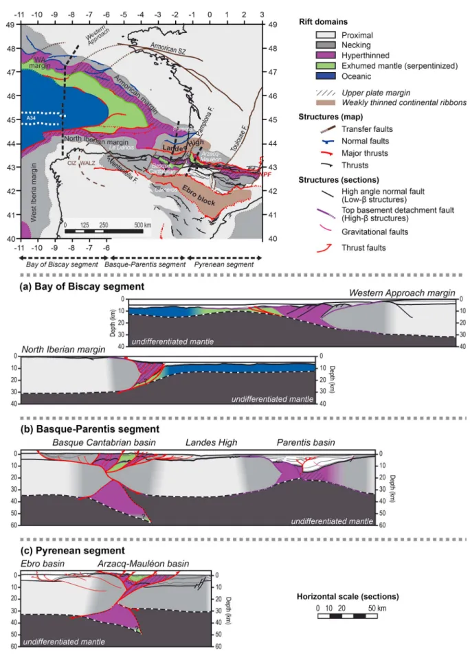
Figure 6. Map of the rift domains preserved in the Bay of Biscay and their fossil analogues from the Pyrenean domain. Extensional rift structures and thrust faults from the Armorican and Western Approach margins are based on the work of Thinon [1999] and own observations. CIZ: Central Iberian zone. WALZ: West Asturian-Leonese zone. NPF: North Pyrenean fault. The location of the geological sections from Figure 7 is indicated in dashed line.
The sedimentary architecture can often be defined by offlapping packages and by onlaps backward onto the basement of the necking domain (outcrop scale observations; Figure 2). The progressive creation of accommodation space can be recorded by deltaic sedimentary systems or slope facies including gravitational systems. A transition from shallow to deeper marine environments can also be observed in underfilled basins (Figure 2).
In the Bay of Biscay, the necking domain corresponds to the continental slope of the Western Approach (over the Meriadsek Terrace), Armorican, and North Iberian margins (including the“Le Danois basin” in the eastern part; Figure 6). The southern part of the Basque-Cantabrian basin, the Organya and Pedraforca basins (as suggested by the restorations of Muñoz [1992], Vergés and García-Senz [2001], and Lagabrielle et al. [2010]), and most of the Arzacq basin may represent fossil analogues of this domain (Figure 6). Narrow remnants of this domain can also be mapped in basins from the eastern and western Pyrenees, respectively, south of the North Pyrenean Frontal thrust and north of the Lakoura thrust (Figure 6; e.g., in the Mendibelza massif [Masini et al., 2014]).
4.1.3. Hyperthinned Domain
Continental crust is typically less than 15 to 10 km thick and associated with a large accommodation space (Figures 2 and 5). Both low- and high-β extensional settings may be observed (Figure 2) and are characterized by half-graben and hyperextended sag basin architectures [Tugend et al., 2014, Figure 2]. Top basement detachment faults commonly lead to local exhumation of middle to lower crustal levels as observed in onshore fossil remnants (e.g., Manatschal [2004] and Figure 2). The infilling history of this domain mainly depends on sedimentary supply and sedimentary sources but is usually associated to thick aggradational sequences and/or deep marine sedimentary sequences (Figure 2).
The occurrence of extremely thinned continental crust was already recognized in the Parentis basin [e.g., Pinet et al., 1987; Bois and Gariel, 1994; Tomassino and Marillier, 1997] and at the toe of the continental slope of the Armorican and Western Approach margins (“neck area” in Thinon et al. [2003]). In the southern Bay of Biscay, this domain is integrated into the accretionary prism of the North Iberian margin, as indicated by refraction velocities [e.g., Ruiz, 2007; Gallart et al., 2004; Roca et al., 2011; Fernández-Viejo et al., 2012]. Onshore in the Pyrenees (Figure 6), this domain is characterized by numerous granulitic rocks (e.g., in the Labourd, Trois Seigneurs, and Agly massifs) interpreted as middle to lower crustal rocks [e.g., Vielzeuf, 1984] exhumed during Cretaceous rifting [e.g., Jammes et al., 2009; Vauchez et al., 2013].
4.1.4. Exhumed Mantle Domain
The onset of the exhumed mantle domain can be observed where complete thinning of the continental crust is achieved (Figure 5c/5d). Local remnants of continental crust may be preserved as extensional allochthons on top of the exhumed mantle basement of this domain (outcrop scale observation; Figure 2). The seismic reflection pattern and velocity structure described from suspected and drilled exhumed mantle domains contrasts with the adjacent hyperthinned and oceanic domains. Seismic reflection observations show a complex set of deep intrabasement reflections (e.g., Armorican margin: Thinon et al. [2003] and Iberian margin: Pickup et al. [1996], Dean et al. [2001], Reston and McDermott [2011], and Sutra et al. [2013]). Refraction studies indicate a downward gradient of velocities commonly interpreted as the progressive decrease in serpentinization with depth [e.g., Minshull, 2009; Reston, 2009, 2010]. Magmatic additions can also be observed within this domain, as indicated by the local occurrence of synhyperextension to posthyperextension alkaline magmatism in onshore remnants of exhumed mantle in the Pyrenees. Offshore, volcanic bodies and volcanoclastic sediments are interpreted on the Armorican margin [Thinon et al., 2003]. This magmatic overprint may progressively become more important toward the oceanic domain. Hyperextended sag basins are often observed in the exhumed mantle domain, sometimes extending to the hyperthinned and necking domains in the case of overfilled basins (e.g., the Angola margin [Unternehr et al., 2010]).
Exhumed mantle has already been proposed tofloor the Armorican basin [Thinon et al., 2003] and suggested in the South Iberian margin [Roca et al., 2011]. Gravity inversion results combined with seismic interpretations enable us to map the eastern termination of the exhumed mantle domain toward the hyperthinned Parentis basin (Figure 6). Onshore, this domain is characterized by the occurrence of mantle bodies and Mesozoic metamorphic rocks included in tectonic units near the North Pyrenean fault in the Pyrenees (Figure 6; e.g., Monchoux [1970], Fabriès et al. [1991, 1998], Lagabrielle and Bodinier [2008], Lagabrielle et al. [2010], and Clerc et al. [2012, 2013]) or within the so-called Nappe des Marbres in the Basque-Cantabrian basin (Figure 6 [Lamare, 1936; Mendia and Gil-Ibarguchi, 1991]).
4.1.5. Oceanic Domain
The transition to the oceanic domain is characterized by a deepening of the Moho and the ramp morphology of the basement referred to as an outer high [Péron-Pinvidic and Manatschal, 2010; Péron-Pinvidic et al., 2013]. Refraction data across this basement high in the Bay of Biscay indicate the presence of an underplated high-velocity body originating in the exhumed mantle domain [Thinon et al., 2003]. This high-velocity structure may suggest a possible overlap between the exhumed mantle and oceanic domains [see also Roca et al., 2011]. It may be interpreted as an underplated gabbroic body similarly to the interpretation of Bronner et al. [2011] for the Iberian-Newfoundland rifted margins. It may also represent the oceanward termination of serpentinized mantle [Thinon et al., 2003] that is overprinted by thefirst oceanic crust. Both interpretations suggest a possible overlap or transition zone between the exhumed mantle and oceanic domains. A specific seismic pattern is also observed, characterized by diffractive and irregular reflections in the upper basement [Thinon et al., 2003] and locally strong reflections parallel to the top basement at deeper levels [Sutra et al., 2013]. Thefirst onlapping and overlying sediments are of postrift age. In the central part of the Bay of Biscay, one drill hole (DSDP site 118 and leg 12 [Laughton et al., 1972]) reached the oceanic basement. This domain is characterized by E-W to ESE-WNW trending magnetic anomalies [Matthews and Williams, 1968] attributed to the magnetic anomaly 34 [e.g., Srivastava et al., 1990]. The absence of the magnetic anomaly 33 [Cande and Kristoffersen, 1977] suggests that seafloor spreading stopped after anomaly 34 and before anomaly 33, corresponding to Santonian-Early Campanian time [e.g., Montadert and Roberts, 1979, Montadert et al., 1979]. No remnants of oceanic domain (ophiolites) can be observed onshore in the Pyrenean or Basque Cantabrian basins [Lagabrielle and Bodinier, 2008].
4.2. Key Structures and Lateral Extent of Domains
The definition of rift domains also relies on the identification of key structures (i.e., compressional, extensional, and transfer fault systems) as they represent markers of the deformation during the different extensional and compressional events.
4.2.1. Compressional Systems
The overall WNW to ESE trend of compressional structures (foreland basins, boundary between internal and external domains) results from the Iberian/European convergence. Compressional deformation is important in the Southern Bay of Biscay and controls the evolution of the North Iberian frontal thrust system [e.g., Derégnaucourt and Boillot, 1982; Roca et al., 2011; Fernández-Viejo et al., 2011, 2012]. In its eastern termination, it represents the boundary between continental and oceanic domains without evidence for oceanic subduction ([Ayarza et al., 2004]; refraction data along the IAM 12 line; [Fernández-Viejo et al., 1998]). To the West, it delimits the accretionary prism and reactivation in the exhumed mantle domain [Roca et al., 2011; Fernández-Viejo et al., 2012]. Locally NW-SE trending thrusts are observed in the Northern Bay of Biscay, mainly located at domain transitions [Thinon et al., 2001].
Most of the compressive structures can be observed onshore. The North and South Pyrenean frontal thrusts delimit the almost E-W trending Pyrenean-Cantabrian orogen from the adjacent foreland basins. Onshore remnants of rift domains are delimited by thrusts systems. Among them, the North Pyrenean fault [e.g., Mattauer, 1968; Choukroune and Mattauer, 1978] and Basque-Cantabrian equivalent, the Leiza fault [Boillot et al., 1973; Choukroune, 1976; Rat, 1988; Combes et al., 1998; Mathey et al., 1999] can be mapped discontinuously.
4.2.2. Extensional Faults
NW-SE to E-W trending extensional structures can be mapped in the Northern Bay of Biscay [Derégnaucourt and Boillot, 1982; Thinon, 1999; Thinon et al., 2003] related to the rifting phase in the Bay of Biscay. Top basement detachment faults may develop to become the boundary between the proximal and necking domains (e.g., Southern boundary of the Parentis basin [Jammes et al., 2010b, 2010c]). Only few half-graben basins (i.e., low-β extensional settings; Figure 2) are described from the hyperthinned domain of the Armorican margin [Thinon, 1999; Thinon et al., 2003]. Remnants of extensional rift structures and top basement extensional detachment faults are described locally onshore in the Mauléon basin [e.g., Canérot et al., 1978; Canérot, 1989; Johnson and Hall, 1989a, 1989b; Jammes et al., 2009; Masini et al., 2014], in the Aulus basin [e.g., Lagabrielle et al., 2010], or in the Basque-Cantabrian basin [e.g., Tavani and Muñoz, 2012; Bodego and Agirrezabala, 2013, and references therein].
4.2.3. Transfer/Transform Faults
A striking observation resulting from this mapping is the importance of transfer faults. These structures strongly segment offshore and onshore rift systems. The segmentation of the Northern Biscay margin is
characterized by NE-SW transfer faults [Derégnaucourt and Boillot, 1982; Thinon et al., 2003] that may be partly related to the Variscan structuration observed onshore [Thinon, 1999]. The offshore prolongation over the continental shelf is underlined by magnetic and gravity trends and is suggested to be partly controlled by the Armorican shear zone [e.g., Sibuet, 1973; Thinon, 1999]. The influence of the inferred structures can be observed on the segmentation of the limit between necking and exhumed mantle domains between the Goban Spur, Western Approach, and Armorican margins (Figure 6). Other inherited structures locally break the NW-SE straight orientation of the southern part of the Armorican margin [Thinon, 1999], but the control of these structures on the subsequent rift structures is complex and not directly observable. In contrast, the South Iberian margin is segmented by NW-SE structures [Derégnaucourt and Boillot, 1982], such as the Ventaniella fault that records a Permo-Carboniferous post-Variscan evolution [Burg et al., 1994a, 1994b].
Fossil remnants of the rift system preserved in the Pyrenean-Cantabrian orogen are segmented by NNE-SSW to NE-SW trending structures. These structures may result from the partial reactivation of Permo-Carboniferous strike-slip or transfer faults [Arthaud and Matte, 1975, 1977; Burg et al., 1994a, 1994b]. Locally they may have been reactivated as normal faults during the formation of Permo-Triassic intracontinental basins [Curnelle et al., 1982]. The observed segmentation may reactivate existing faults, but these preexisting faults (Permian or older) cannot be traced with confidence across the Pyrenees.
To the east, the Cevennes fault system delimits the Pyrenean from the Provencal domain (Figure 6); to the south, it also may partly control the shape of the South Pyrenean compressional thrust system [Vergés et al., 2002; Muñoz, 1992].
The Toulouse fault, also referred to as the Villefrance or Sillon Houiller fault, can be mapped from the Massif Central region to the northern Aquitaine basin (Figure 6). The southern continuation toward the Pyrenees delimits the eastern termination of the Arzacq-Aquitaine basin from the Occitan high [Curnelle et al., 1982]. This structure can be identified on gravity inversion maps as a major crustal discontinuity (Figure 5). In the Axial zone, a transfer zone may be mapped discontinuously at the eastern boundary of a large Carboniferous basin and farther to the south to the west of the Organya basin (Figure 6) in the South Pyrenean zone (segmentation also described by Muñoz [1992] and Vergés and García-Senz [2001]).
The Pamplona fault delimits the Mauléon and the Basque-Cantabrian basins [Turner, 1996]. Although this structure is not exposed continuously, it controlled the Mesozoic sedimentation [Larrasoaña et al., 2003] and represents a major crustal offset observed from gravity modeling (Bouguer anomaly map [Jammes et al., 2010c]).
The segmentation of the Basque-Cantabrian basin is well defined from its subdivision into an eastern “Alava” and western“Peri-Asturian” domain [e.g., Rat, 1988; García-Mondéjar et al., 1996]. This NE-SW structuration terminates toward the Landes High to the north. The western termination of Basque-Cantabrian basin is poorly defined due the Cenozoic tectonic uplift and erosion of Mesozoic sediments south of the Le Danois basin and north of the Duero basin [Gallastegui et al., 2002; Pedreira et al., 2003, 2007; Alonso et al., 2007]. In this area, Roca et al. [2011] proposed the existence of the Santander soft transfer zone that would relay the compressional front of the Pyrenees to the north into the Bay of Biscay. This transfer zone may also be suggested from gravity inversion maps (Figure 5) facilitating the relay of the necking domain of the South Iberian margin to the South at the eastern termination of the Le Danois basin (Figure 6).
4.3. Two Distinct Rift Systems
The previous definition of rift domains, associated structures, and segmentation enables us to distinguish two extensional systems: (1) the Bay of Biscay-Parentis rift in the NW and (2) the Pyrenean-Basque-Cantabrian rift to the SE. Both preserve a specific spatial and temporal evolution.
4.3.1. The Bay of Biscay-Parentis Rift
The V-shaped Bay of Biscay-Parentis rift system preserves different stages of the lithospheric-scale thinning process ranging from hyperthinned basins in the East to oceanic domains in the West. The Parentis basin is interpreted to show a progressive lateral decrease in extension going eastward [Jammes et al., 2010c]. Onshore, a crustal discontinuity is observed (Figure 5) that may represent the northern continuation of the Pamplona fault (e.g., the Bordeaux fault [Lefort et al., 1997]). This structure corresponds to the eastern termination of the Parentis basin. We have mapped the continuation of the relatively sharp necking and
hyperthinned domains of the northern Parentis basin westward into the Armorican margin. To the south, the Landes High forms a weakly thinned crustal block connecting south-westward to the necking domain of the North Iberian margin (Figure 6).
The initiation of extensional to transtensional deformation in the Bay of Biscay rift system is difficult to date with precision and relies on local observations. A phase of pre-Cretaceous extensional deformation may be recorded by a Late Jurassic subsidence in the Parentis basin [Brunet, 1994] and by a thickening of the pre-Cretaceous sequence toward the basin center (e.g., Ibis fault of Bois and Gariel [1994] and Jammes et al. [2010a, 2010b, 2010c]). Hyperextensional processes may have been initiated during the Early Cretaceous (Berriasian to Barremian) resulting in the formation of the necking and hyperthinned domains. During the late Aptian, mantle may have been exhumed in the Bay of Biscay as suggested by Thinon et al. [2002]. The onset of seafloor spreading is dated around Aptian-Albian time [Montadert et al., 1979; Boillot, 1984; Vergés and García-Senz, 2001] but may not be synchronous throughout the entire Bay of Biscay.
The major change in rift domain architecture between the Western Approach and Armorican margins occurs across the Armorican shear zone corresponding to a partially inherited transfer/transform fault (Figure 6). A similar change in the overall domain architecture can be observed between the eastern and western North Iberian margin west of the Le Danois basin (Figure 6).
4.3.2. The Pyrenean-Basque-Cantabrian Rift
The Landes High and the Ebro block (Figure 6) form weakly thinned crustal blocks delimiting to the North and to the South the Pyrenean-Basque-Cantabrian rift system from the Bay of Biscay-Parentis (Figures 5 and 6; see also Roca et al. [2011]) and Central Iberian rift systems [e.g., Salas and Casas, 1993; Salas et al., 2001]. Onshore, the overall crustal architecture of the different domains is not preserved. Only remnants included in the compressional nappe stack can be observed. Complete ophiolite sequences that could be considered as remnants of typical oceanic lithosphere are never observed within the Pyrenean-Basque-Cantabrian rift system [Lagabrielle and Bodinier, 2008]. The only Cretaceous magmatic additions observed are late Aptian to early Santonian (~113 to 85 Ma [Lamolda et al., 1983; Montigny et al., 1986]) alkaline sills andflows preserved into remnants of an exhumed mantle domain or the overlying sediments. This observation suggests that this extensional system did not evolve into a mature oceanic domain. Furthermore, mantle outcrops are usually associated with small fragments of continental crust (in the Pyrenees: Duée et al. [1984], Fortané et al. [1986], Lagabrielle et al. [2010], and Debroas et al. [2010]; and Basque-Cantabrian basin: Mendia and Gil-Ibarguchi [1991]) indicating that probably only local windows of exhumed mantle existed.
The increasing subsidence recorded in the onshore Arzacq and Tarbes basins [Désegaulx and Brunet, 1990] during the Late Jurassic to Early Cretaceous may indirectly date the onset of transtensional deformation [Canérot, 2008; Jammes et al., 2009]. Hyperextension only initiated in the late Aptian to Albian time in the Pyrenean-Basque-Cantabrian rift [Jammes et al., 2009; Lagabrielle et al., 2010] coinciding with the onset of seafloor spreading in the Bay of Biscay [Montadert et al., 1979]. The sedimentary record preserved in the Pyrenean-Cantabrian orogen indicates a progressive deepening of the basin from late Aptian to mid-Albian (Pyrenees: Debroas [1987, 1990] and Basque-Cantabrian basin: García-Mondéjar et al. [1996, 2005]). Mantle exhumation processes may have lasted until early Cenomanian as suggested by the reworking of mantle rocks in mid-Albian to lower Cenomanian breccias (Figure 3; Urdach breccia: Jammes et al. [2009], Debroas et al. [2010], and Lagabrielle et al. [2010]; and Aulus breccia: Clerc et al. [2012]).
In spite of the well-defined NE-SW segmentation, an overall lateral continuity of hyperextended domains can be observed throughout the Pyrenean orogen (Figure 6). The Pamplona fault represents a major crustal discontinuity [Turner, 1996; Larrasoaña et al., 2003; Jammes et al., 2010c] delimiting the Basque-Cantabrian from the Arzacq-Mauléon basin.
5. Structural Evolution: Insights From Geological Sections
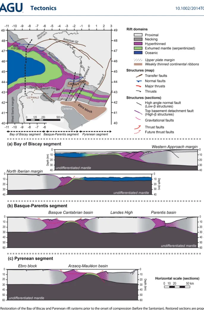
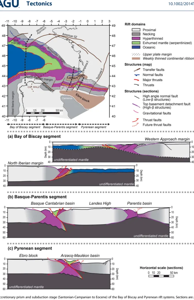
The mapping of the rift domains across the Bay of Biscay-Pyrenees enables us to characterize the progressive compressional overprint of the former rift systems. To the west, the initiation of reactivation can be investigated to the east, a complete reactivation of rift structures is observed. In order to decipher the possible interaction between the two extensional rift systems during the Late Cretaceous
Figure 7. Geological sections, location Figure 6 (a) Bay of Biscay segment: the architecture is based on the Norgasis 11–12 [after Tugend et al., 2014] and IAM 12 seismic profiles (see also Figure 8). (b) Basque-Parentis segment: the section is a composite between the depth interpretation of the ECORS Bay of Biscay seismic profile and the gravity modeling proposed by Pedreira et al. [2003] for the Basque-Cantabrian basin. (c) Pyrenean segment: the section is based on the interpretation of the ECORS Arzacq-W Pyrenees and the southern extension is modified after Teixell [1998].
toOligocene compression, three segments are distinguished (Figures 6 and 7): (1) a western“Bay of Biscay segment”; (2) a central “Basque-Parentis segment” preserving heterogeneously reactivated hyperextended domains; and (3) an eastern“Pyrenean segment” that is completely inverted, exemplified by the Mauléon-Arzacq basin.
5.1. Western Bay of Biscay Segment
5.1.1. Constraints From Seismic Interpretations and Gravity Inversion
The western Bay of Biscay segment initiates at the western termination of the onshore Pyrenean-Basque-Cantabrian rift system. Located at the junction with the Atlantic Ocean, it preserves the ultimate stage of lithosphere thinning in the Bay of Biscay.
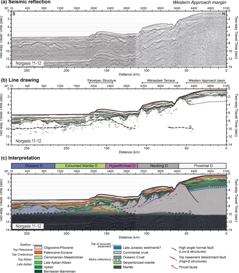
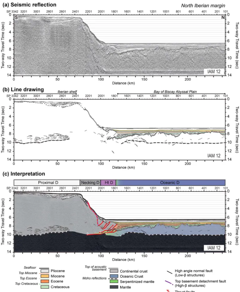
In order to characterize the architecture of this domain, two conjugate geological sections are proposed, extending from the proximal to oceanic domains in the Western Approach margin to the North (Figures 7a and 8) and across the North Iberian margin to the South (Figures 7a and 9). The sediment and basement architectures of these sections are derived from the interpretation of the Norgasis 11–12 seismic sections (Figure 8 [Avedik et al., 1993, 1996; Thinon, 1999]) and IAM 12 line (Figure 8 [Banda et al., 1995; Alvarez-Marron et al., 1997]), extending into the Western Approach and North Iberian margins, respectively. Moho depth is determined from gravity inversion results (Figure 5; parameters are given in Table 1) combined with refraction data under the proximal domain of the North Iberian margin [Fernández-Viejo et al., 1998].
5.1.2. Architecture of the Western Approach Margin
The rift-related crustal architecture of the Western Approach margin is well preserved. Detailed
descriptions of seismic observations supporting the interpretation of this section are proposed by Tugend et al. [2014] and summarized below. The proximal domain is characterized by half-graben type basins (Figures 7a and 8) and by deformation interpreted to decouple at midcrustal levels. No drill hole has reached the basement of the necking domain, but based on the overlying sedimentary architecture (Figure 8) and onshore analogy (Figure 2 [Tugend et al., 2014]), it is suggested to be structured by a conjugate set of top basement detachment faults delimiting a crustal necking zone [Mohn et al., 2012; Sutra et al., 2013]. The hyperthinned domain is characterized by a tilted block architecture limited by short-offset normal faults dipping oceanward (Figures 7a and 8). These structures are rooting onto the “S”-reflector (Figure 8 [De Charpal et al., 1978; Montadert et al., 1979; Thinon, 1999]) that is interpreted as the crust-mantle boundary. The southern edge of this domain is proposed to be structured by a top basement detachment fault that exhumed rocks from the lower crust and mantle to the seafloor during the final stage of rifting. The occurrence of an extensional allochthon overlaying the exhumed mantle is proposed. It is delimited at its base by the“S”-reflector on seismic sections (Figure 8; [Thinon, 1999]). The transition to the oceanic domain may not be a sharp boundary and may result from a progressive magmatic overprint of the exhumed mantle domain as suggested by refraction data [Thinon et al., 2003]. The only important compressional reactivation is observed close to the transition between the exhumed mantle and
hyperthinned domains, forming the Trevelyan structure [Debyser et al., 1971; Derégnaucourt and Boillot, 1982; Thinon et al., 2001]. The associated thrust fault system is interpreted to root in the serpentinized upper mantle (Figures 7a and 8).
5.1.3. Reactivation of the North Iberian Margin
The distal part of the North Iberian margin was interpreted in the past as an accretionary prism related to the formation of an oceanic subduction [e.g., Boillot, 1984; Alvarez-Marron et al., 1997]. Based on the refraction results [Fernández-Viejo et al., 1998; Ruiz, 2007], any important underthrusting of oceanic crust below the South Iberian margin is precluded. Therefore, many authors suggested a complete or partial overprint of the former rift architecture [Gallastegui et al., 2002; Fernández-Viejo and Gallastegui, 2005; Alonso et al., 2007; Roca et al., 2011; Fernández-Viejo et al., 2012]. The identification of the rift domains (Figure 6) enables us to propose a new interpretation that characterizes the deformation in each rift domain clearly unraveling the role of the rift-inherited architecture. No major evidence of reactivation can be observed from the proximal and necking domains preserving their rift-related architecture delimited oceanward by a crustal necking zone similar to the structures proposed for the Western Approach margin. The accretionary wedge characterizing the distal part of the North Iberian margin (Figure 9) is interpreted as the former hyperthinned domain that has been reactivated (Figure 7a). Refraction velocities are compatible with the hypothesis of a deformed wedge made of continental crust and sediments rather than of sediments only [Ruiz, 2007; Fernández-Viejo
Figure 8. Norgasis 11 and 12 seismic section along the Western Approach margin. (a) Seismic reflection, (b) line drawing, and (c) interpretation proposed in this study. The location of the seismic lines is the same as Figure 7a.
Figure 9. IAM 12 seismic section along the North Iberian margin. (a) Seismic reflection, (b) line drawing, and (c) interpretation proposed in this study. The location of the seismic lines is the same as Figure 7a.
et al., 2012]. The existence of an exhumed mantle domain is proposed northward and eastward and may have also occurred in this part of the Bay of Biscay. We suggest that it may be partly underthrust below the hyperthinned domain during the compressional overprint and formation of a Tertiaryflexural basin on top of the oceanic domain (Figures 7a and 9 [Alvarez-Marron et al., 1997]). In our interpretation, the exhumed serpentinized mantle represents a low-friction surface between the hyperthinned domain and the oceanic domain (Figure 7a).
5.2. Eastern Bay of Biscay: Parentis and Basque-Cantabrian Segment 5.2.1. Constraints From Geological and Geophysical Data Sets
In the Parentis and Basque-Cantabrian segment, both preserved and reactivated rift structures can be investigated. The eastern Bay of Biscay is characterized by its progressive termination into the hyperthinned Parentis basin. Eastward this segment terminates toward the Pamplona fault delimiting the Basque-Cantabrian basin from the Western Pyrenees.
The geological section shown in Figure 7b is based on the interpretation of the sedimentary and top basement architecture of the ECORS Bay of Biscay section [Pinet et al., 1987; Bois and Gariel, 1994] located in the Parentis basin. The southward extension into the Basque-Cantabrian basin is based on publishedfield studies supported by local subsurface data [Instituto Geologico Y Minero De Espana (IGME), 1987]. Moho depth is based on refraction studies in the Parentis basin [Tomassino and Marillier, 1997]. In the Basque-Cantabrian basin, the crustal architecture is based on one of the possible solutions derived from gravity and magnetic modeling proposed by Pedreira et al. [2007].
5.2.2. The Rift Architecture Preserved in the Parentis Basin
The Parentis basin is only weakly reactivated in its central part and the overall rift-related sedimentary and crustal architectures are relatively well preserved (Figure 7b). The architecture of the basin is strongly asymmetric unraveling a major crustal discontinuity toward the emplacement of the so-called subvertical Ibis fault (Figure 7b [Jammes et al., 2010a, 2010b, 2010c]). The northern geometry is characterized by the progressive transition from a proximal to a hyperthinned domain without any major rift structure and the complete record of the prehyperextension, synhyperextension, and posthyperextension sedimentary sequences. The southern part of the basin is more complex. The necking domain is structured by a conjugate system of detachment faults. Evidence for such structures is based on drill hole observations (the Saint Girons en Marensin and Contis boreholes [Jammes et al., 2010b]). The structural limit between the northern and southern part of the hyperthinned domain of the Parentis basin is also interpreted as a top basement detachment fault rooting toward the Ibis fault and associated with salt tectonics and diapir formation [e.g., Mathieu, 1986; Biteau and Canérot, 2007; Jammes et al., 2010b]. The Landes High and the Cantabrian shelf belonging to the proximal domain represent a weakly thinned crustal block and form a major boundary between the Parentis and Basque-Cantabrian basin [see also Roca et al., 2011].
5.2.3. Rift Remnants and Reactivation in the Basque-Cantabrian Basin
In contrast the Basque-Cantabrian basin to the South is completely inverted (Figure 7b). Sedimentary sequences are decoupled on upper Triassic evaporites [Cámara, 1997] and the basement is buried under thick sedimentary sequences. Field and subsurface observations provide good constraints on the stratigraphic evolution of the Mesozoic sediments [e.g., Soler et al., 1981; García-Mondéjar et al., 1985; Rat, 1988; IGME, 1987] and on locally preserved rift-related structures [e.g., García-Mondéjar et al., 1996; Tavani and Muñoz, 2012; Bodego and Agirrezabala, 2013]. Similarly as for the northern Landes high, the Rioja shelf to the South (buried under the Ebro basin and forming the western continuation of the Ebro block, Figure 6) is representative of a proximal domain, characterized by the deposition of thin Late Cretaceous posthyperextension shallow marine sediments [e.g., Cámara, 1997]. The sedimentary sequences of the conjugate necking domains are preserved in the Zumbaya and Alava synclines (respectively, in the northern and southern part of the basin). These units are characterized by thickening of synhyperextensional (late Aptian to Cenomanian) to posthyperextensional sequences toward the basin axis and locally absent prehyperextensional sequences (Castillo 5 [IGME, 1987]). The North Biscay and Bilbao anticline are mapped as remnants of hyperthinned domains and characterized by thick prehyperextension sediments. The Bay of Biscay syncline is mapped as the western continuation of the“Nappe des Marbres” locally sampling mantle rocks and associated high-temperature low-pressure (HT-LP) metamorphic marbles of Mesozoic age [Mendia and Gil-Ibarguchi, 1991] representative of a former exhumed mantle domain. An important gravity anomaly is centered on the basin and interpreted to result from the stacking of lower crustal rocks
[Pedreira et al., 2003, 2007] or mantle rocks emplaced at shallow levels during compression. In analogy with the interpretation proposed for the Labourd anomaly [Jammes et al., 2010c], we favor the mantle body solution that would be coherent with this unit being a remnant of a former exhumed, partly serpentinized, mantle domain. Nevertheless, the lower crustal interpretation proposed by Pedreira et al. [2003, 2007] cannot be excluded. Another important observation resulting from the gravity modeling proposed by Pedreira et al. [2007] is the occurrence of a large northward dipping crustal root reaching a 55 to 60 km depth and interpreted as the former thinner basement of the Basque-Cantabrian basin [Pedreira, 2004; Pedreira et al., 2007].
5.3. Arzacq-Mauléon Basin: Pyrenean Segment 5.3.1. Constraints From Field and Subsurface Geology
The Pyrenean segment initiates at the eastern termination of the Parentis and Basque-Cantabrian basins and is delimited from the two basins by the Pamplona fault. Therefore, this segment only preserves rift remnants derived from the former hyperextended Pyrenean-Basque-Cantabrian rift system.
Insights on the sedimentary and basement architecture come from the reinterpretation of the ECORS Arzacq-W Pyrenees seismic profile [Daignières et al., 1994] extended to the South based on the Anso transect proposed by Teixell [1998]. Field geology, subsurface observations [BRGM et al., 1974], and local refraction data [Daignières et al., 1982; Banda et al., 1983] are combined to further constrain the interpretation proposed in Figure 7c.
5.3.2. Compressional Architecture of a Reactivated Hyperextended Basin
Arguments for the determination of rift-related remnants in the Arzacq-Mauléon basin have been previously presented and described relying on the identification of key field observations (Figure 3; see also Tugend et al. [2014]). Field observations from the“Béarnais range” area, in the eastern part of the basins (Figure 3) are used to further constrain the compressional overprint of former rift domains (Figures 7c, 10, and 11). The present-day geometry of the Mauléon basin results from its inversion within a large pop-up structure along north and south vergent thrusts (Figures 7c and 10).
To the south, distal parts of the basin (corresponding to the former hyperextended domain) are thrust over the proximal domain preserved in the axial zone along the south-directed Lakoura thrust system and lateral equivalents (Figures 7c, 10, and 11 [Muñoz, 1992; Teixell, 1998]). The proximal domain is weakly deformed as a large-scale anticline (geological sections Figure 10; see also Teixell [1990]) and by local thick-skin structures related to thefinal stage of deformation (D2 phase; e.g., Guarga and Gavarnie thrusts Figure 7c and Eaux-Chaudes thrust Figure 10). The sedimentary cover of the axial zone is characterized by thin-skin thrusts decoupling in Upper Triassic evaporites (Teixell [1998]; geological section BB′ Figure 10).
The transition from the proximal to necking domains (see structural maps; Figures 3, 10, and 11) corresponds to a thrust fault characterized by an intense deformation of the sediments close to the contact (e.g., Upper Triassic formation within the Bedous unit; Figure 11 [Canérot et al., 2001; Ternet et al., 2004a, 2004b]). Locally, this thrust fault is folded by the anticlinal deformation of the axial zone as indicated by the steep northward dipping Cretaceous cover of the axial zone (Figures 10 and 11). Remnants of the necking domain are only locally sampled within the Bedous-Mendibelza unit as syncline structures. In contrast, the rift-related sedimentary and basement architecture of the conjugate remnants of the necking domain preserved in the Arzacq basin is interpreted to be well preserved (Figure 7c).
The initial contact between units preserving the necking and hyperthinned domains is only locally preserved [Masini et al., 2014]. In most cases it is overprinted by north-directed thrusts resulting from the second phase of deformation (Figures 7c, 10, and 11). The hyperthinned and exhumed mantle domains are characterized by the widespread occurrence of this second phase of deformation that locally invert and overprint the tectonic units where remnants of these domains are preserved (e.g., the Ossau thrust [Canérot et al., 2001]; Figures 7c, 10, and 11). As a result, a large part of the hyperthinned and exhumed mantle domains may be underthrust as suggested in the geological sections in Figures 7c and 10.
Field observations from the Mauléon basin unravel the contrast in compressional deformation between the different rift domains. The proximal domain is only weakly deformed, whereas the hyperthinned and exhumed mantle domains are affected by a stronger compressional overprint.
![Figure 7. Geological sections, location Figure 6 (a) Bay of Biscay segment: the architecture is based on the Norgasis 11 – 12 [after Tugend et al., 2014] and IAM 12 seismic pro fi les (see also Figure 8)](https://thumb-eu.123doks.com/thumbv2/123doknet/14786091.598872/18.918.92.819.99.1052/figure-geological-sections-location-figure-biscay-architecture-norgasis.webp)