Publisher’s version / Version de l'éditeur:
Engineering Journal, 45, 3, pp. 31-38, 1962-05-01
READ THESE TERMS AND CONDITIONS CAREFULLY BEFORE USING THIS WEBSITE. https://nrc-publications.canada.ca/eng/copyright
Vous avez des questions? Nous pouvons vous aider. Pour communiquer directement avec un auteur, consultez la
première page de la revue dans laquelle son article a été publié afin de trouver ses coordonnées. Si vous n’arrivez pas à les repérer, communiquez avec nous à [email protected].
Questions? Contact the NRC Publications Archive team at
[email protected]. If you wish to email the authors directly, please see the first page of the publication for their contact information.
NRC Publications Archive
Archives des publications du CNRC
This publication could be one of several versions: author’s original, accepted manuscript or the publisher’s version. / La version de cette publication peut être l’une des suivantes : la version prépublication de l’auteur, la version acceptée du manuscrit ou la version de l’éditeur.
Access and use of this website and the material on it are subject to the Terms and Conditions set forth at
Planning avalanche defence works for the Trans-Canada Highway at
Rogers Pass, B.C.
Schaerer, P. A.
https://publications-cnrc.canada.ca/fra/droits
L’accès à ce site Web et l’utilisation de son contenu sont assujettis aux conditions présentées dans le site LISEZ CES CONDITIONS ATTENTIVEMENT AVANT D’UTILISER CE SITE WEB.
NRC Publications Record / Notice d'Archives des publications de CNRC:
https://nrc-publications.canada.ca/eng/view/object/?id=aa939b6c-659a-4f88-b6d4-3c009044f55e https://publications-cnrc.canada.ca/fra/voir/objet/?id=aa939b6c-659a-4f88-b6d4-3c009044f55e
s e r
TH1
PRICE 25 CENTS
This is a joint paper of @he Departmenst of Public Works and the National Research Council.
REPRINTED FROM
THE ENGINEERING JOURNAL, VOL. 45, NO. 3, MARCH 1962, P.P. 31-38
RESEARCH PAPER NO.
152
O F T H E
DIVISION O F BUILDING RESEARCH
OTTAWA MAY 1962
NRC
6732This publication is being distributed by the Division of Building Re- search of the National Research Council. It should not be reproduced in whole or in part, without permission of the original publisher. The Division would be glad to be of assistance in obtaining such permission.
Publications of the Division of Building Research may be obtained by mail- ing the appropriate remittance, (a Bank, Express, or Post Ofice Money Order or a cheque made payable at par in Ottawa, to the Receiver General of Canada, credit National Research Council) to the National Research Council, Ottawa. Stamps are not acceptable.
A
coupon system has been introduced to make payments for publications relatively simple. Coupons are available in denominations of 5, 25 and 50 cents, and may be obtained by making a remittance as indicated above. These coupons may be used for the purchase of all National Research Council publica- tions including specifications of the Canadian Government Specifications Board.sion of Building Research, National Research Council, Ottawa, Canada.
VALANCHE DEFENCE
For T h e Trans-Canada Highway
T
ROGERS PASS, B.C.
P. A. Schaerer
Former Research Officer, Snow and Ice Section, Division of Building Research, Niltion01 Research Coc~ncil, Ottawa
SELKIRK Mountain range in e interior of British Columbia ne of the major obstacles to be the Trans-Canada High- way. Various routes through this range have been investigated; that through Rogers Pass was se1ected.l The pass lies 'between the towns of Golden and Revelstoke in Glacier National Park and was chosen by the Canadian Pacific Railway as rhe route
for the first railway link between Eastern Canada and the Pacific Coast. It was in use from 1885 until 1916 when the Connaught tunnel was built and the railway line (through the Pass was albandoned.
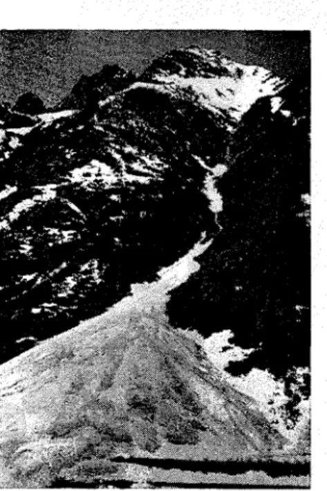
I t was known that lavalanches would be one of the major problems for any road built through the Sel- kirk range (Fig. l). Accordingly, in 1953 the Department of Public Works
of Canada, which is responsible for the construction of the Trans-Canlada Highway through Glacier National Park, began reconnaissance work f the highway and organized a prel inary survey of avalanche sites an avalanche activity. These avalanch observations were under rhe directio of N. C. Gardner. In 1956 an ava- lanche observation station was estab- lished to carry out the more detailed
search, co-operated in thc organizn- tion of the avalanche observ:~tion st'?- tion. Bet\\reen 1957 '1ncl 1960 thc a:ithor was in chargc of this s t ~ t ~ o n and was responsible lor p1.1nning the aval~lnche defence. This p q c r tl:,- scribes in brief rhe obscrvatlo~ls \vhich were m,lde 2nd summ'lrucs the dc- fence \vhlch was chosen.
Terrain
The summit of Rogers Pass is 4,300 ft. above se,a level, and t!::. pealts of the Selkirk range risc to
11,000 St. Tlic vallcys ;~ssocinteil \\lii-i~ the Pass are short a n d comparative-I? steep on the east side, but risc Lo the summit with a g~lilclual climb from the west. A typical Selkirk valley is narrow ancl has steep sides (Figs. 2, 3).
The m o u n t ~ ~ i n sides on the Rogers PASS route have a terrace located be- tween 5,500 and 6,500 ft. labove sea level (Figs. 4, 5). The terrace goes gradually over into the scree slopes and rockfaces which rise to the moun- tdin ridges. Below the tcrrace a sharp clrop over cliffs lcacls to talus slopes ancl alluvial fans into the valley bot- tom \vhich is between 300 ancl 1,000 Et. wicle. In some plaees the mountain sides are close together, resulting in a narrow V-shapecl valley. The highway is cut into the talus slopes and alluvi- al fans, ancl except tor two short sec- tions is located on the north sicle of
Figure 3: Illecillewaet valley on the west side of Rogers Pass. The avalanclle sites are the open paths on both sides of the valley.
Figure 2: Bear Creelc valley on the east can be seen in the left foreground.
the river \\dlich flows through the valley. The lower mountain sides and valle!is are covered with heavy timber and clei~se brush. Trees become scat- terecl on the terrace, leaving space for alpine meaclows.
Climate
side of Rogers Pass. Part of the highway
snowfall is usually f0110~r:cl by one or several d ~ y s wit11 only light snowfall. During winters of light snowfall three '
storms may occur yielding more than 16 in. of snow in a three-day period, but during winters of heavy snowfall 10 such s t o ~ m s may occur. Only occa- sionally, labout once in fhree years, Rogeis Pass is in thc region popu-
larly kno\vn as the interior wet belt of British Columbia.' High annual ~recipitation and heavy snowfall are its most distinctive features. The aver- age annual precipitation, measured be- tween 1921 and 1950, at Glacier close to the summit of Rogers Pass, is 1 8 in. of rain ancl 342 in. of snow, while the maximum annual snowfall ever observed \\.as 680 in., measured dur- ing thc winter 1953-54. The magni- tude ancl frequency of the 24-hour sno\vfalls at Glacier cluring the win- ters bet\veen 1953 ancl 1960 are
show^^ in Tn:ble I.
is there a silowstorm that contributes more than 36 in. in a three-day peri- od. Most s~lowfalls are accompanied by wind which deposits large amounts of snow on the lee side of the moun- tain ridges. The mlaximum depth of snow on the ground in the valley is about 1 0 0 in., and on the mountain, at the 6,700-ft. level, the greatest measured depth of 160 in. was ob- served on May 1, 1959.
Temperature during a snowstorm nor- mally i>anges bet\veen 2 0 and 32°F. After the storm has ended, it is usual for cloudy weather to continue and the temperature to change relatively slo~vlv. Frenuentlv. however. the , , Storms \\-it11 '1 high rate of snowfall temperature rises during a sno\vstolm are not frequcnt ancl are usually of ancl the snowfall in the valleys short duration. A day \\-it11 hcavy changes to rain. Tlle temperature falls
TABLE I
Frecluency of Snowfalls at Glacie~
Tolal
Nzor~ber 0.i (lags with m~owl'alls snv~ql'all jor llre
Less than winter,
I [:int,er 4 fn. . to 1 I 19 lo 20 i.n. 80 in. .in..
-- -
195sj39. . .
:
s 5 4 1 3 - 442. . .
1959/60. 8-1 29 1 - 368
below 0 ° F only a few times during the winter and this cold weather U S I I - ally does not coi~tinue for more than a week.
Avalanche Survey
The avalanche survey had to produce the following informatiol~ about the aveilage and very large avalanches that occur at each site: their rupture zone, path ancl terminus;
their depth and width;
their frequency of occurrence; the prevailing conditions responsil)lc for thcir occurrence.
Information was o l ~ t ~ ~ i n e d by monthly patrols through the area during the first three years, and after 1956 by daily and weekly patrols to record observations on each av'11anche that occurred, even on those which ter- minated far from the highway. The rupture zone and path of important avalanches was sketched on photo- gl~aphs and all avalanches that de- posited snow near or on the highway right-of-way were traced on location plans. Infoimation on the conditions that cause avalanches was obtiained through snow cover and weather db- servations at four observation sites
in the valley and two mountain ob- servatories located at an elevation of zvbout 6,800 ft. Precipitation and tem- perature measurements made at Gla- cier previous to 1953 were available from the Meteorological Branch of the Department of Transport.
T h e avalanche survey was completed by site studies in summer land winter. Extent, slope angle, exposure, soil conditions, age of [trees in the rupture zone, path and terminus were ob- served at each site. Valuable infor- mation was also obtained from the Canadian Pacific Railway Company, Figure 4: Avalanche site Cheops No. 2.
who kindly made available their rec- ords on all avalanches that had af- fected railway operation during the period 1910 to 1952.
In 1960, when the final plans were developed for the first stage of clc- fence, there were available detailed observations of avalanche activity during seven winters ancl partial ob- servations from ano'thel. 40 years. Records of avalanches that occr~rred during the years before 1953 rc- vealed that therc were periods of more than one year in whicll avalanche ac- tivity was a maxiurn. These periods of maximum #activity are associ'~tcd with periods of high snowfall and high temperature. Unfortunately, the present survey was conducted during what the records indicate to be a period of low activity, 'both as to the size and the number of avalanches. Observations taken do not, therefore, cover the worst possible conditions which may be encountered. The sur- vey did produce a good picture of avalanches that may be encountered during an aveiiage year, but maxi- mum conditions had to be deduced from the few large avalanches that occurred during the observation peri- od and from the incomplete observa- tions of earlier years.
Avalanche Sites
Avalanche sites can be easily recognized by ,the scars on the tim- bered mountainside (Fig. 2). The area where avalanches start to slide and where 'the bulk of snow origin- ates is called the rupture zone. T h e previously descr?bed terrace at la11 elevation of a4bout 6,000 ft. divides the rupture zone in many of the avalanche sites. T h e avalanches rup- ture in a lower zone on or at the toe of the cliHs below the terrace or in an upper zone on the steep slopes rising to the mountain ridges (Fig. 5). Many of the small avalanches b~hich originate in the upper zone stop on the terrace. Large avalanches overrun the terrace and gain a high speed as 'they fall over the steep slopes below. There is evi- dence that many lower rupture zones at Rogers Pass were once covered with timber that prevented the occurrence of avalanches. Fires appear to have removed these trees and destroyed a very effective niatural defence. The avalanche path is the track fol- lowecl by an avalanche during its de- scent. The majority of avalanches a t Rogers Pass are confined in gullies which have been carved in the moun- tains by running water (Fig. 5). A few avalanches reach the valley over open, bare slopes (Fig. 4). The ter- minus is the area hvllere the main body of the avalanche comes to rest.
Figure 5: Avalanche site Tupper No. 2. The rupture zone is at the cliffs and snowfields below tlle mountain peak; the gully is the avalanche path and the terminus of the avalanche is on the wide alluvial fan. The terrace is above the cliffs with the waterfall.
Avalanches slow clown on the alluvilal fan or the talus slope at the lower part of the mountain, Minor ones will stop there 'but major avalanches ad- vance into the valley and in some cases reach the opposite side. The narrow valley in Rogers Pass and the fact that avalanches reach the valley floor from both sides made it impossible to construct a highway that would avoid all dangerous sites. In the 35-mile highway section be- tween the east boundary of Glacier National Park land Albert Canyon on d ~ e west side 74 avalanche sites had to be crossed; 61 of these lie within the Park. As the avalanches do not occur under the same conditions at each site, and since the topography and area of #the rupture zones and the avalanche paths may produce avd- lanches of different sizes, the hazard to the highway varies from one ava- h n c h e site to the next.
The 74 avalanche sites can b e class- ified as follows:
Nine sites where minor and major avalanches occur frequently ancl where at least one major lavalanche can be expected to reach the Iiigh- way every year;
Twenty-one sites wllci-e minor avalanches occur frequently and usu- ally reach the highway once or inorc than once each winter; the mass of the sliding snow is small and may not cover the whole width of the highway; large avalanc~l~es occtu. occasionally but not cvery winter.
highway from these avalanches #would lanches before this amount has been usulally be airborne and little would reached. A continuous snowfall, ex- be deposited on the highway. ceeding 30 in. of new snow, may The most active avalanches are cause unusually large lavalanches. Dry concentrated in a narrow defile, snow avalanches move on the surface about 2% miles long, between Mt. and are accompanied by a cloud of
Wet Snow Direct Action Avalanches
These avalanches occur when Avalanche c~assifications have snowfalls are fdlowed immediately
and the defence c'hosen accordingly. deep snow simultaneously at many sites (Fig. 6).
Dry Snow Direct Action Avalanches
The majority of all avalanches Dry Snow Delayed Action Avalanches
Is of 10 in. when accompanied observation of the snow cover and
ed action avalanches unstable snow cover, snowfall and wind over a long period of time. high temperatures
8
affect large sections of simultaneously.
Spring Thaw Avalanches
These avalanches occur as a r sult of the loss of cohesion of sn as it melts. They usually occur cycles at many sites simultaneously during a few hot days, but single occurrences were observed also. The avalanches can involve large masses of wet, heavy snow land often slide on the ground. They usually have a lower speed and a smaller range than the dry snow avalandhes, and tend to flow in channels.
Avalanche Defence Methods
From the observations made on avalanches and their causes, it was necessary to folmulate a general de- rfence plan for the whole route, land to indicate the defence method that should be applied for each avalanche site within the general plan. To the greatest possible extent the Trans- Canlada Highway was constructed through areas safe !from avalanches. When an avalanche path could not be avoided, \attention was given to locat- ing the highway in such a way as to reduce the effect of the avalanches, e.g. placing the highway near the tip of the avalanche lte~minus where it would be reached infrequently by avalanches or high on rhe mountain- side where the avalanche path is narrow and snow clearing to the downhill side easier. Cuts were day- lighted in order to avoid deep snow deposits.
Much valuable experience is now available from countries such as Switzerland, Austria land $he United States on various methods of defence against avalanches.
Active Defence
Structures and vegetation (per- manent measures)
Rekining 'barriers Snowfences and wind-
bahfles
Braking barriers: Earth mounds, Catching
dams Diverting dams Snowsheds Reforestation
Explosives (temporary mea- sures)
All metl~ocls may b e applied alone or in combination. They arc cle- scribecl below ancl rationalizecl for the defence at Rogers P'lss.
Retaining ban iers a1 e constlucted in the rupture zone mlcl contiol av'l- lanches a t their source. Thcy can create a completely sale site. It was touncl that costs for barriers in rhe renlote and llarge rupture zones ivhicli occur a t Rogels Pass iilere prohibitive. Retaining b a ~ r i c r s coulcl 1)e built eco- llomically only a t minor av'11anche sites where thc rupture zone is close to the highway, e.g. on long, steep banks fro111 which significant anlounts of snow may slicle and cover the highway.
Figure 7: Avalanche site Cheops No. 1 with earth mounds in the terminus.
Snowfences and winclbafflcs con- trol in the rupturc zone the clrifting snow that may create an a v a l ~ u ~ c h e hazard. I t was considerecl that this
defence is not suitable for Rogers Pass, because the structures must b e built at high elevations ancl on ex- posed mountai~l ridges ivhcrc con- struction ancl maintenance are clif'l'i- cult. This defence does not prevent dry or wet snow clirect action lava- lanches that are not accompaniecl b y wind. Furtl~ermore, it is possiblc that deep snow would soon cover the structures.
U ~ a k i n g barriers are obstaclcs in the avalnnche path wwrhicll slo\w~ clown or stop the avalanches belorc they reach the highway. Of tllc various
Avalanche warning (temporary measure)
Highwdy closures Avalanche detection
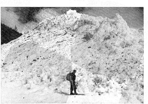
Figure 6: Ternlinus of a wet snow direct action avalanche on the future highway The sno\v is 45 feet deep.
structures wvhich can be usccl, earth mouncls ancl catching clams wwJere judgecl to b e suibable.
Earth mounds are built in twvo or more roivs in a checkered arrange- ment on the flat section of the pakh \\here the avalanches woulcl normally have sloivecl down considerably (Figs.
7, 8). At Rogers Pass, the alluvial fans at the tcrminus of the avalanche sites have low slope angles and are
a suitable location for mounds. A series of experimental mounds wvas constructecl in 1957. Obscrvntions (luring thc following three winters shonrecl that a t locatio~ls where the n~ou~lcls wvcrc constructecl dry snow\.
awlnlanclles were slowecl d o w n whi passing between the monnds a n terminated just beyoncl; spring th avalanches stopped at the first row mounds. I t wvas decided that moun sl~oulcl b c built as clefence against \I
snow avalanches ancl smaller d r y sno avalanches a t othcr sites where not illore than three avalanches p e r winter are likely to occur. Because construc- tion costs are low, they can b e built as clefence against large dry snow ava- lanches also. In this case, it is not e x ~ e c t e d dlat thc mounds will stop the avalanches completely, b u t they shoulcl retain 'a great part of the lleavicr slicling snow and reduce the
here not more than two struction methods have changed dur-
Diverting dams which confine the width of the avalanches. A snowshed ilt in the path of the avalanches.
to be built in the of smaller
avalanches, were designed for deposit loacls of 450 p.s.f. and 1 5 0 p.s.f. and 300 p.s.f. moving load. A paper giv- ing cletailecl information on the de- sign of sno~vshecls is being prepared. Reforestation in the rupture zone serves the same purpose as retaining barriers. Rcforestatio~l projects must be associated with tempomry retain- ing barricrs, cvliich because of expense were not collsiclered for Rogers Pass. - Explosives are a temporary de- fence nleasurc that is cheap and ver- satile. When tlie avalanche hazard dictates avalancl~es can be released uncler control by detonating explo- sives in the rupture zone. Under cer- tain circumstances, particularly when therc is 3 hazard for dry snow de-
layecl action avalanches, t h e explosion call creatc a sk,~ble snow cover with- out proclucing an avalmche. b1~1ch experience on this method of ava-
the U.S.A. and in ~witzerlland, where it has proved effective and economi- cal against direct action avalanches and clry snow delayecl action 'ava- lanches, although not against spring thaw avalanches.
The normal technique is to use projectiles fired from an lartillery wea- pon. Studies and experiments indi- cated that the 75-mm. and 105-mm. howitzer are most suitable for ava- lanche control at Rogers Pass. Some rupture zoncs are too rugged for eco- nomionl firing and at a few avalanche sites no suitable firing position coulcl be found. Since firing must often be done cluring snowstornls when main- tenance personnel are already busy with snow removal \\rork, and be- cause a large portion of the highway is in the Natiolllal Park wvhich should not be converted into an artillery range, it was decided that artillery fire should be used only against ava- lanches that cannot be controlled eco- nomically by orher methocls. Hancl- placed ancl preplantecl explosive charges were found unsuitable at Rogers Pass because of the remote-
ss of the rupture zones.
Highway closure for the duration of dangerous avalanche conditions is a simple protective measure. I t re- quires an organization to study snow cover ancl weather, evalulate avalanche hazard and order closure and re- opening as necessary. It was con- sidered that although the Rogers Pass route must be open for the whole winter, short closures would be per- An lavalanche cletection system consists of an electronic device which detects an avalanche as it occurs and operates warning signals. 111 a long path, an lavalanclle may be cletectecl some time before it reaches the high- way and traflic sig~ials coulcl warn oncoming vehicles before they enter the dangerous area. In short paths the device may only signla1 avalanche occurrence to the maintenance head- quarters. The former use of the sys- tem may be feasible at a later stage of defence at a few selected lavalanche sites at Rogers Pass, but d ~ e latter use of the system was chosen for two sites where frequent sn1'1ll avalanches may cover the highway. The Radio and Electrical Engineering Division of rho National Research Council has built an avalanche detection device For Rogers Pass that is now being tested.
Avalanche Hazard Evaluation and Prediction
Defence by means of explosives ancl highway closure requires the evaluation of avalanche hazard to de-
telmine wlvhen explosives should be used and wvhen the highway must bc closed or reopened. An avalanche is causecl by cliMerent faotors associated with terrain, snow cover, snokviall, wind and temperature, (all in close relationship. Certain rules have been established through experience on the dependence of avalanche hazard on these factors. Haaarcl can be evaluated quite accurately 'for the time of ob- servation, but the prediction of future hazarcl is only as good as the weather forecast. In practice, the avalanche hazard forecaster has to assume that weather will follow a certain pattern and his prediction is based 011 ?his. The evaluation of the avalanche hazard can be approached by two different methods, called here the testing method and the anlalytic method.
The testing method has been de- velopecl in S ~ i t z e r l a n d ; ~ evaluation of the avalanche hazard is based on snow cover observations. Stability of a snow cover can b e tested directly from time to time and weather factors such as snowfall, wind and tempera- ture used to determine its stability between observations. With expen- ence and tests, it has been found \vhich factors may lead to a fracture and which conclitions contribute to stabilization.
The analytic method is the tech- nique used in the U.S. Forest Ser- vice.5 Most avalanche sites with which this service was concerned produced direct action avalanches. Observations over a few winters indicated the wea- ther and snow cover factors mainly responsible for creating them. By cle- termining the magnitude of each fac- tor, it was possible to evaluate ava- lanche hazard. This method requires more acculate weather observations than the testing methocl, but plocluces better results.
In practice, both methocls are
observation station in the Rogers Pass area made snow cover and w observations iand evaluated dai avalanche hazard. The testing me was usecl as the basis for evalua Weather condi~tions that cc~used lanches at specific sites were an lysed and rules for forecasting dire action avalanches were found. 0 t h studies were made to establish a ru of thumb for the hazard evaluati of spring thaw avalanches. In 19
the responsibility for avalanche evalu- ation and prediction was transferre to the Department of Northern fairs and National Resources. The perience gained in combining testing method with (the anal methocl has been passed 011 to t
Department. Defence Plan
Study of avallanche defence f the Rogers Pass route indicated bh the cost of a defence that wou guarantee a continuously open hig way would b e unreasonably high. was realized also that the required structures for such a defence ]could not be built before rhe scheduled completion clate of the highway. On the other hancl it was recognized that a passive clefence only would not avoid frequent and Iong closures, which coulcl not (be accepted for the Trans-Canlada Highway. Based on these consiclerations a plan with three stages of defence const
bining active defence wibh pas defence by highway closures, chosen. The length of time that highway woulcl probably be close each winter woulcl be decreased the completion of each st
The first stage of be in operation when the opened, and the other sta introduced later wvhen more
TABLE I1
Corllparison of the Different Defences Based on 1960-19f31 Prices
Clost~re o f Iiighwal~ Est~nzated Costs in a n Average VVint
First Stage: caoinbined active and
passive defencc 5,300,000 52,000
Third Stagc:
active defencc only 4,400,000 70,000 Konc
t 12 hours af
e First Stage of Defence
ction a t sites:
snowfalls yielding less than 16 quently than once in 10 years. Ad- in. new snow when iaccom- ditional snowsheds, retaining barriers panied by wind, or less than in rupture zones close to the highway,
- where spring thaw avalan- be built.