GJI
Seismology
The 1356 Basel earthquake: an interdisciplinary revision
Donat F¨ah,
1Monika Gisler,
1Bernard Jaggi,
2Philipp K¨astli,
1Thomas Lutz,
2Virgilio Masciadri,
3Christoph Matt,
4Dieter Mayer-Rosa,
5Dorothee Rippmann,
6Gabriela Schwarz-Zanetti,
1J¨urg Tauber
7and Thomas Wenk
81Swiss Seismological Service, ETH Zurich, CH-8092 Zurich, Switzerland. E-mail: [email protected] 2Basler Denkmalpflege, Unterer Rheinweg 26, CH-4058 Basel, Switzerland
3Klassisch-Philologisches Seminar, Universit¨at Zurich, R¨amistr. 68, CH-8001 Zurich, Switzerland 4Arch¨aologische Bodenforschung des Kantons Basel-Stadt, Petersgraben 11, CH-4001 Basel, Switzerland 5Schwandenholzstrasse 260, 8046 Zurich, Switzerland
6Historisches Seminar, Universit¨at Zurich, Karl Schmid-Strasse 4, CH-8006 Zurich, Switzerland 7Arch¨aologie und Museum Baselland, Amtshausgasse 7, CH-4410 Liestal, Switzerland
8Wenk Erdbebeningenieurwesen und Baudynamik GmbH, Postfach 6063, CH-8023 Zurich, Switzerland
Accepted 2009 January 26. Received 2009 January 26; in original form 2007 April 25
S U M M A R Y
Within historical times one of the most damaging events in intra-plate Europe was the 1356 Basel earthquake. Given its significance for assessing regional seismic hazard in central Europe, an interdisciplinary project was launched in 2005 to re-explore this event. Our ef-fort aimed to incorporate techniques from history, seismology, archaeology, paleoseismology and engineering. New and reinterpreted historical data from Basel and its surroundings plus archaeological findings on buildings that survived the event and still exist enabled this macro-seismic assessment. Palaeoseismological studies combined with historical evidence provided additional data. For the surrounding areas, archaeology offers sparse information on some cas-tles and churches, sometimes supported by historical records. A contemporary source allows some reconstruction of the stronger fore- and aftershocks.
This expanded information base improves our sense of the event’s damage and conse-quences. For the city of Basel, the relatively abundant archaeological data allowed us to assess statistically the macroseismic intensity at IX, although the pattern of damage was scattered. Data points for the expected area of damage around Basel are not distributed regularly. The ab-sence of historical and archaeological findings for southern Germany might be due to archival problems; future investigation may improve this situation.
Our results confirm that the Basel earthquake was the most destructive known for central Europe. Intensities up to VIII are found within a radius of about 30 km. Analysing the macroseismic field confirms our former assessment of the event and shows an epicenter located about 10 km south of Basel. The most probable range for the moment magnitude Mw is between 6.7 and 7.1.
Key words: Palaeoseismology; Seismicity and tectonics; Europe.
1 I N T R O D U C T I O N
The 1356 Basel earthquake is well known as one of the most dam-aging events in intra-plate Europe within historical times (Fig. 1). It was one of several devastating catastrophes in the 14th century. In the summer of 1338, grasshoppers devoured the harvest; in July and August 1342 flooding reduced the harvest again; in the years 1345– 1347 the most adverse weather known in the last millennium struck and famine occurred (Schwarz-Zanetti 1998). In 1349, the Black Death reached Basel and reduced its population significantly. Anti-Jewish pogroms swept through several cities, among them Basel. In
1354, the northern part of the city of Basel (see Fig. 2) was partly destroyed by fire (Meyer 2006).
The consequence is a difficulty when it comes to studying the sequence of events on 1356 October 18, through contemporary sources. They include a few detailed period records like the Basel city manual Rotes Buch (Wackernagel 1856) and the chronicles of Heinrich of Diessenhofen (Boehmer 1868b) or of Konrad of Waldighofen (Sieber 1882). These specify what might have oc-curred in Basel on that day (Table 1). The earthquake sequence started after noon of October 18; its fourth shock was first to strike buildings in the city. A series of strong aftershocks followed. At
Figure 1. Fictional depiction of the destruction of the City of Basel (M¨unster 1550).
around 9 (UTC) pm, the main shock hit the Basel area, causing major damage within a radius of approximately 30 km. An ensuing fire destroyed parts of the inner city and the quarter St. Alban Vorstadt (StABS: Ratsb¨ucher A1; Wackernagel 1856; B¨ohmer 1868b; Closener 1870; Bernoulli 1890). The pattern of October 18 and 19 is well documented in the above-mentioned chronicle by Heinrich of Diessenhofen (circa 1300–1376) (Boehmer 1868b) who noted the time and strength of each shock felt at Konstanz, 120 km east of Basel (Table 1). The shocks of the following 10 days are summarized only.
We are thus able to depict the event on a general level. Difficulties start when we would like to go more into detail, for example on the distribution of damage. It is next to impossible to differentiate which shock(s) provoked the actual damage. The documents closest to the event give accounts of vast destruction in the city of Basel; none of these written reports, however, distinguishes between the several shocks. We were unable to assign damage to individual earthquakes or damage as a consequence of repeated shaking. Furthermore, the documents do not distinguish between damage from shaking versus fire. What’s more, many familiar commentaries originate from the 16th, 17th or 18th century and distort our view of the event. We can, however, surmise that the two strongest shocks (numbers 4 and 5 in Table 1) caused damage (B¨ohmer 1868b).
Distinguishing what might have come to pass is also difficult when we seek the number of casualties. Contemporary testimony by Johannes de Rupescissa in Avignon, based on an eyewitness re-port (Sieber 1882), refers to a large number of victims (‘innumeris habitatoribus interfectis’). Diessenhofen’s chronicle mentions vic-tims as well but without giving a precise number (Boehmer 1868b). Other contemporary sources, like ‘Das Rote Buch’ or manual of the city of Basel (StABS: Ratsb¨ucher A1; Wackernagel 1856; Bernoulli 1890), contain no details. The names of only three casualties are distinguishable (Meyer 2006). However, in historical documents af-ter the 14th century, concrete figures appear: the number of 300 victims is given in the ‘Wurstisen Chronicle’ of Basel originating around 1580 (Wackernagel 1856). Miscellanies of the 16th century report a maximum figure of 2000 victims. Since Basel had an over-all population of 6000–7000 at the time (see Figs 2 and 3 for a geographical overview), this number is highly improbable (Meyer 2006). Concerning the rural population, a low number of two to
five inhabitants per square kilometer can be assumed, based on esti-mates for the Jura area south of Basel (Bickel 1947) and the region of Sissach (BL) in the late 15th century, respectively (Othenin-Girard 1994). Thus, the overall number of victims remains uncer-tain. According to the Diessenhofen chronicle (Boehmer 1868b), after the first strong shock in the afternoon (around 5 pm) people in Basel left most buildings. Many did not re-enter their homes due to repeated strong shocks, a precaution that must have limited casualties.
Several studies have tried to highlight the sequence of events on 1356 October 18. In the 19th century, it was the philologist Wil-helm Wackernagel from Basel who, to commemorate the event’s 5th centenary, collected 27 historical documents (stemming from 24 dif-ferent authors) to present an overview of the quake (Wackernagel 1856). This collection—focusing on the Basel area—represents a potential wealth of significant information, even though fewer than 10 of the texts originate in the 14th century. The compilation has been the basis for interpreting the 1356 event as in the macro-seismic studies by Cadiot et al. (1979) and Mayer-Rosa & Cadiot (1979). Recent studies by Fouquet (2003), Meyer (1990, 2006) and the web-database ‘sisfrance’ (Bureau de recherches g´eologiques et mini`eres 2007) have improved our understanding by integrating ad-ditional records. The work of Wechsler (1987), on the other hand, used official account books for Basel to summarize overall damage in the city. Other regional studies have been carried out by Bernard
et al. (1997) and Lambert et al. (2005), the latter discussing some
persistent difficulties with historical names. Besides these historical and macroseismic studies, others have investigated the damage area (Sabourault et al. 2003; Lambert et al. 2005) or possible source locations (e.g. Meyer et al. 1994; Meghraoui et al. 2001). Paleo-seismic studies (e.g. Becker & Davenport 2003; Monecke et al. 2004; Ferry et al. 2005) as well as the collection of graphic rep-resentations of the event completed these investigations (Kozak & Thompson 1991).
Our study presents historical and archaeological investigation into this event, as well as its interpretation and parametrization. Our effort integrates techniques from several different scholarly fields: history, seismology, archaeology, paleoseismology and engineer-ing. Our main goal was to create a more robust database. Research in archives and libraries has exposed new contemporary and copied
Figure 2. Geographical map of the area of Basel published in 1880 [Schumacher 1878/1880; coordinates: Swiss National Grid in (km)], and representation of the city of Basel in 1615, seen from the North (Merian 1615). Klein-Basel is the part of the city north of the Rhine river; Gross-Basel is the part south of the river Rhine. Construction of the outer city walls (shown in red) was initiated some years after the 1356 earthquake, so we can assume a slightly smaller size for the city in the year of the earthquake. Today the area is densely populated.
historical material, especially on locations outside Basel. Historical material includes the chronicle of Heinrich of Rebdorf (B¨ohmer 1868a, p. 509) and a deed of a consecration of an altar in the monastery Moutier-Grandval (Trouillat 1861, 13 Juni 1361, pp. 177–179); documents about repairs in the Berner Leutkirche, 1359 April 26 (Fontes Rerum Bernensium 1903, Vol. 8, Nr. 795), in the castle Grasburg 1357–1359, 1363–1365 and 1379–1381 (Burri 1935), in the monastery Blotzheim (Boner 1945) and probably in the castle R¨oteln near Kaiserstuhl 1359 (GLA: Ms. 5 Conv. 548. Perg. REX II 5462, 5453), documents defining reduced taxes in Gelterkinden 1366 (StABS: St. Alban E fol. 37), a regulation about clothes in Speyer (StASp: Inv.-Nr. 1A6, 1356 November 11), a second fund-raising appeal for the Basel Cathedral, 1364 July 10 (StABS: Domstifturkunden, No 130), a contract in Saint-Ursanne (AcSU: Carton 25, 1388 Avril 20), a writ of the year 1458 with a hint about the castle Madlen near Pratteln (StABL: Urkunde 537) and some documents about houses in Basel, for example, Haus Zum Landser, Schl¨usselberg 15 (StABS: Domstifturkunden, No III 41) or Haus Blatzheim, Rittergasse 7-9 (Trouillat 1861, pp.
108–110) and the Bitterlinshof, Rittergasse 20 (Liebenau 1867, Vol. 5, Urkunde XC, 1357 September 16), see Table 2. A deed about the castle Soyhi`eres disproved alleged damage in 1356 (Trouillat 1858, pp. 457–460). New findings in archaeology and art history concerning the churches of Rodersdorf (Loertscher 1957), Olsberg (Courvoisier & Sennhauser 1990), Oltingue (Schweitzer et
al. 1990), Muttenz (Ewald 1998), Rheinfelden (Frey 2000),
Kaiseraugst (Kontic 2006) and the castle of R¨otteln near L¨orrach (Schomann, unpublished data) clarify effects of the 1356 event. Ad-ditionally, in chronicles of the 17th and 18th century, two unknown copies of lost sources were found, such as the manuscript ‘Synopsis Annalium Monasterij S. Petri in nigra Silva’, by Pater Gregorius Baumeister (EAFr: Ms. Ha 583), and the print ‘Epitome Fastorum Lucellensium’ by Buchinger (1666). Finally, to illustrate the per-ception of the disaster by later artists, we integrated an early fictive picture of the Basel earthquake in two exemplars of the Konstanzer Weltchronik (BSB: Germ. 426 and PLNY: Spencer Collection Ms. 100) (Fig. 4). For further details, see Gisler et al. (2006), Schwarz-Zanetti et al. (2006) and Gisler et al. (2008). Copies of lost sources
Table 1. Summary of the earthquakes of 1356 October 18 and 19, as ob-served in Konstanz by Heinrich von Diessenhofen (Boehmer 1868b) T, UTC.
Date and time Intensity Number of
shocks October 18
Between noon and vespers
• First earthquake, medium [1]
• Followed by two weaker shocks [2–3] Vespers, around 5 pm
• Strong shock (stronger than [2] and [3]) [4] October 19, begins with the darkness of October 18
Bedtime, around 9 pm, to midnight six shocks
• Main shock, around 9 pm [5]
• Five weaker shocks [6–10]
After noon
• Intensity unknown [11]
After vespers
• Intensity unknown [12]
[1356] Item mense octobris anno predicto lvi. in die sancti Luce ewangeliste [oct. 18] post prandium et ante vesperas venit terremotus magnus Constantie, et postea eadem die duo parvi motus ante vesperas similiter venerunt. Item quartus maior quam duo precedentes dum vespere pulsabantur. Et in nocte subsequenti a primo sompno usque ad medium eiusdem noctis mota est terra sexies, sed primus maior inter nocturnos motus terre. Et proxima die sequenti duo motus septimus post meridiem, alius post vesperas. [As on 1356 October 18, shortly after noon and before vespers (ca. 5 pm), a vast earthquake occurred at Konstanz, and later two smaller shocks followed, similar to the one before the evening meal. A fourth shock occurred throughout vespers, larger than the two precedents. And in the following night, starting at bedtime to midnight, the earth shook six times, the first of the shocks being the major one. The following day two shocks occurred, the seventh (in total) after noon, the other after vespers.]
Figure 3. Geographical overview of the area, providing the names given in the text.
were only accepted as supplementing contemporary material. This decision helped to exclude errors originating in later historiography. Archaeological data for the area around the city of Basel con-sist of dendro-chronological dating or indications of fast destruc-tion like entire parts of collapsed masonry or a large number of valuable, mainly metallic objects that can be dated around 1350. If possible, written records were compared against archaeological findings and vice versa. Not all information was treated equally but was interpreted as more or less reliable. As a consequence, in the macroseismic section, we supply two different tables (Tables 4 and 5). For the city of Basel particularly, a new approach was applied by combining archaeological findings on buildings that survived the event with engineering assessments of the respective structures. This endeavour has been amended with results from excavating remnant layers of buildings no longer there.
In the first two sections, we discuss the outcomes of the historical, archaeological and paleoseismic investigations (Sections 2 and 3) to assign intensities to the potential sites (Section 4). Then we discuss potential faults.
2 H I S T O R I C A L A N D
A R C H A E O L O G I C A L A P P R O A C H E S 2.1 Investigating the 14th century: some remarks
Historical seismology studies earthquakes of the past to better esti-mate present regional and local seismic hazards. Such research in-volves finding and interpreting historical documents via established approaches, which are refined as the work progresses. Successful investigation of earthquake records depends on the organization of archives and libraries and the availability of working tools like guides and inventories. Systematic questions about written sources,
Table 2. (Continued.)
Note: The types of information used to assess the building as well as an excerpt of the individual findings are listed. Buildings with neither vulnerability nor damage grade estimation as well as the town gates pulled down in the 19th century are not included into intensity assessment. The abbreviations are given in the references.
Documents and compilations used are as follows:
(1) Historical records report the destruction of the neighbouring buildings of the convent and church of St. Leonhard (Maurer 1961). (2) For example: StABS: Domstifturkunden, No 99, No 130; Diessenhofen in B¨ohmer 1868b; Maurer 2005, pp. 227–248.
(3) Officialurkunde GLA Karlsruhe, zit. n. StABS: HGB Rheinsprung, Nachtr¨age; Jahresberichte der Arch¨aologischen Bodenforschung 2005, pp. 238–251; Die Kunstdenkm¨aler des Kantons Basel-Stadt 2007, Vol. VII, pp. 369–373.
(4) Die Kunstdenkm¨aler des Kantons Basel-Stadt 2007, Vol. VII, pp. 118–120; StABS: Domstifturkunden, No III 41. (5) Published archaeological report: Brandenberger & Jaggi 2002.
(6) Die Kunstdenkm¨aler des Kantons Basel-Stadt 1966, Vol. V, pp. 319–416; Bernoulli 1890, Vol. I, pp. 499–501. (7) Published archaeological report: Wyss & Jaggi 1987.
(8) Published archaeological report: Reicke 1999. (9) Liebenau 1867.
(10) Trouillat 1861.
traces of the events at archaeological sites and pictorial records es-tablish a base for interpreting the data. Descriptions of the event in different records at hand have a rather similar structure. At best, they provide the type of event and its date, the site of observation, an account of local phenomena and information from other loca-tions. Yet more often than not it was unclear whether the record described a particular site (i.e. a town or a village). In such cases, the information was not considered for macroseismic assessment.
We have already pointed out the scarcity of contemporary records. A further problem stems from several extant lists of allegedly de-stroyed castles in the wider region of Basel: the so-called Burgen-namenlisten. A few contemporary sources mention the complete destruction of many or even all castles within a radius of approxi-mately 16–32 km (Schwarz-Zanetti et al. 2006). The official man-ual of the city of Basel, the ‘Rotes Buch’ (StABS: Ratsb¨ucher A1), was resumed shortly after the earthquake and reports on destroyed castles in the area without naming them or giving an exact number. In 1362, a native of Strasbourg, Fritsche Closener (∼1315–1390/1396), notes the destruction of 60 castles (Closener 1870), whereas Heinrich of Diessenhofen (∼1300–1376) records 46 destroyed in the diocese of Basel (Boehmer 1868b). Around 1360, the famous poet Francesco Petrarca (1304–1374), probably staying in Milano during the earthquake, mentions the destruction of at least 80 castles (Carraud & Tognon 2002). The ‘Konstanzer Weltchronik’, compiled at the end of the 14th century, lists the num-ber as 130 in the four surrounding dioceses (BSB: Cgm 426; PLNY: Spencer 100, KO 29; Kern 1869). The quantity of destroyed
cas-tles thus varies immensely and none of these records offers specific names.
From the 15th century onwards, nevertheless, several lists emerged with names of 60 or more castles destroyed in the Basel region. Although none was strictly contemporary, these were later used extensively (Mayer-Rosa & Cadiot 1979; Lambert et al. 2005). Tracing back, we find that these lists originated in two records still at hand which date to the first half of the 15th century: the ‘Basler Zus¨atze in der S¨achsischen Weltchronik oder Repgauische Chronik’ (UBBS: Ms. E VI 26; Wackernagel 1856) and the ‘Klingenberger Chronik’ (Henne 1861; Gamper 1984). None of these lists, though, is explicit about its specific function. We do not know why the collection was carried out or what sample it reproduces.
In addition, some names for these castles no longer exist and are thus difficult to recognize and localize. Several authors have tried to identify them (M¨uller 1956; Meyer 1981, 2006; Lambert et al. 2005; Wild 2006). Lambert et al. (2005) completed an important correc-tive study. They propose new locations for the Sundgau Castles. We traced the lists of destroyed castles (‘Burgennamenlisten’) used in this and other macroseismic studies. Yet, these ‘Burgennamenlisten’ refer to two samples from the first half of the 15th century and are thus not contemporary. What’s more, both lists are imprecise about their specific aim. As a consequence, we did not integrate them into our macroseismic analysis unless damage to particular castles was confirmed by other historical sources or archaeological findings.
In what follows, we present results of the archaeological and historical investigations into Basel and then its surrounding area.
Figure 4. Fictional picture of the Basel earthquake in the Konstanzer Weltchronik (BSB: Cgm 426).
2.2 Historical and archaeological investigations of the city of Basel
Written records concerning the event in the city of Basel are numer-ous but unspecific (see Wackernagel 1856). When it comes to detail, as in the distribution of damage, sources remain insufficient. The documents closest to the event give an account of vast destruction in the city and a devastating fire in its inner walls and at St. Al-ban Vorstadt (StABS: Ratsb¨ucher A1; Wackernagel 1856; B¨ohmer 1868b; Closener 1870; Bernoulli 1890). Unfortunately none of these written reports distinguishes between the several shocks, so we were unable to assign damage to individual earthquakes or as a consequence of repeated shaking. Furthermore, they do not distin-guish damage from shaking and that from fire. Probably the two strongest shocks (numbers 4 and 5 in Table 1) both caused great harm (B¨ohmer 1868b).
The city of Basel is of particular interest due to a wealth of archaeological data. Since its founding in 1962, the Basel Archae-ological Department has analysed more than 2100 excavation sites in the city; 700 reports exist for the time before 1962. After the creation of a soil archaeology unit, a section for building archae-ology was established in 1978 within the ‘Basler Denkmalpflege’ (Historic Building Section of the Canton of Basel), an institution for preserving Basel’s monuments and history. This research unit is working as a component in medieval archaeology and examines all material artefacts in the Canton Basel-Stadt area, including all his-torical buildings in any state of preservation and completeness. In the past three decades, more than 600 objects have been examined. These are not equally distributed over the city and their investigation shows large differences in rigor. Some quarters are covered densely with sites; in others only a few data points exist.
Two types of data were analysed in our project. The first refers to excavation of layers with indication of fire and debris includ-ing objects and foundations of buildinclud-ings that no longer exist. The second type refers to extant parts or entire buildings from the pre-earthquake period and those for which good documentation exists between 1356 and their demolition.
Soil archaeology
Reports from the 2800 excavation sites in the city of Basel1 were analysed for any evidence of the 1356 earthquake. Of these, only a few hundred had potential information: 800 sites were checked for possible earthquake connections of which 200 were investigated in more detail. Only 54 were included in this study. After more careful consideration, only six sites could be related to the 1356 event:
Fischmarkt 3 (excavated in 1927), ‘Gerbergasse 28’ (1935),
‘Andreasplatz 7—12’ (1983), ‘Leonhardsgraben 47’ (1985), ‘Nadelberg 32’ (1987) and ‘Lohnhof ’ (1996). The location of the six sites is given in Fig. 5. These locations were selected using findings dating from before the earthquake. From the number and significance of objects at these six sites and debris found nearby, we assume that they were probably deposited during or after a catas-trophic event. Traces of fire were often detectable. New buildings were constructed above the levelled debris layer.
The most valuable site was ‘Fischmarkt 3’, with many significant objects in a debris layer with traces of fire (Fig. 6). A relevant discovery is also available from a city wall tower at Lohnhof (Matt & Rentzel 2002). Its walls and a wooden ceiling from the year 1358 (dendro-chronological dating) were completely rebuilt: a possible indication of the earthquake. The connection with the earthquake is established, because the known city fires (see below) attacked other quarters. Furthermore, historical records report the destruction of the neighbouring buildings of the convent and church of ‘St. Leonhard’ (Maurer 1961).
The low number of useful excavation sites is the result of two city fires in 1354 (all of Klein-Basel, the part of the city north of the Rhine river) and 1377 (a part of Gross-Basel near the town hall; Gross-Basel is the part of the city south of the river Rhine). The occurrence of two significant fires before and after the earthquake along with its associated fire damage creates difficulties in dating fire damage between 1354 and 1377. A basement filled with debris cannot necessarily be directly related to the earthquake; it could be due to one of the mentioned fires or a fire that destroyed only that building. In some cases, archaeological findings allow us to locate damaged or destroyed buildings, even though estimating the degree of damage is difficult. Information from the soil archaeology can, however, provide additional insight into feasible damage occurrence to extant buildings as in the case of Lohnhof.
The absence of debris does not offer information on whether or not damage in the specific area occurred. We can assume for example that debris was disposed of in the Rhine river, a common practice then. At the ‘M¨unsterh¨ugel’ (M¨unster hill), many findings from the Celtic and Roman ages are extant. However, in its soil layers, no archaeological evidence for an earthquake exists for the 14th century. Yet we know that the ‘Basler M¨unster’ (main cathedral) was severely affected, like other buildings in the area of the M¨unster hill, and we might assume the removal of debris and reuse of material (Basler M¨unsterbauverein 1895; Wechsler 1987).
1According to the database of the Arch¨aologische Bodenforschung (May
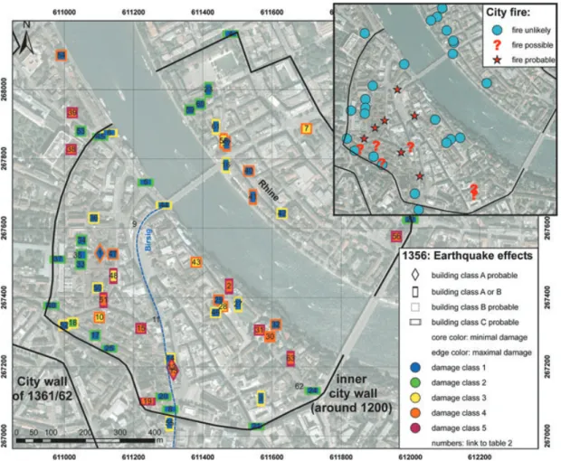
Figure 5. Location of the sites in Basel, for which archaeological data related to the 1356 earthquake exist (circle: building; squares: excavation sites). All indicated locations are given. Klein-Basel is the part of the city north of the Rhine river; Gross-Basel is the part south of the river Rhine. St. Alban Vorstadt is a quarter of the city of Basel around St. Alban church.
Archaeology of buildings
Since the 1970s, the Building Archaeology Section of the ‘Basler Denkmalpflege (DPF-BS)’ has collected data on more than 600 buildings (the results of the investigations are published annually in the Jahresberichte der Arch¨aologischen Bodenforschung des Kan-tons Basel-Stadt; see references). These buildings were explored prior to their alteration, rebuilding or demolition. The geographi-cal distribution of the investigated buildings was arbitrary since it was related to construction activities in the city. Little data is avail-able for buildings demolished before the data collection started. The database therefore provides a somewhat random distribution. Of the 600 reports, 120 could be identified as having potential earthquake information.
The earthquake of 1356 has special significance in the build-ing history of Basel even though it has not in itself been a focus of research for the Building Archaeology Section. Over 30 years of research, evidence of the damage caused by the earthquake has frequently come to light. In many buildings, dating from the mid-14th century, different methods of construction can be distinguished and associated with periods before or after the event (cf. Dossiers Bauforschung DPF-BS, in particular 2006/218, D 1998/10, 2000/7, D 1983/23, D 1983/21, D 1999/26). Masonry methods changed after the earthquake; the use of bricks significantly increased and they were systematically combined with quarried stonework. This modified masonry technique assists in the interpretation and
dat-ing of survivdat-ing walls. Classification of different builddat-ing phases is based on the chronological identification of successive struc-tures, the characteristics of the materials used and functional and stylistic developments. Thus, rough dating is relatively error free and straightforward as far as the time window of the earthquake is concerned. For an accurate, year-exact identification, however, dendro-chronological dating of the wood used for building is re-quired. Generally speaking, there is room for interpretation as far as there is causal connection between dated building phases and the earthquake. Unambiguous dating requires the support of written historical documents.
The building reports were carefully analysed to give summary information on specific sites (see Table 2). Dendro-chronological dating exists for some of the buildings at different levels of construc-tion, allowing us to deduce the sequence in the building’s history. Under optimum conditions, dendro-chronology permits the dating of wood with an accuracy of 1 year. If a piece of bark survives on the wood sample, the felling of the tree can be exactly dated. When the border zone between the sapwood and the heartwood is still present, the date of the felling of the tree can be estimated within 20 years (‘terminus post quem’). Age determinations shortly after 1356, taken together with traces of fire in the stonework and plaster, and the style of workmanship were therefore of special interest, indicating reconstruction after the earthquake. More difficult for interpretation are age determinations of wood dated before the year
Figure 6. Selection of objects found in a debris layer at Fischmarkt 3 (Photo: Philippe Saurbeck). These date to the second quarter of the 14th century. The stove tiles and other findings show remarkable traces of fire. This might result from the fire following the 1356 earthquake, because this part of the city was not affected by the fires of 1354 and 1377.
1356, because recycling of material in the reconstruction cannot be excluded.
The archaeological information was complemented both by con-temporary historical sources that mentioned specific buildings and by surviving mural paintings dated to the pre-earthquake period. The investigation included mostly private residential buildings but also some monasteries and several churches. Some towers of the city wall survived the earthquake without significant damage. However, most no longer exist, so they were assessed using historical drawings.
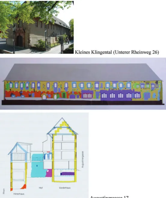
Six buildings from the time before the quake have been proven to have suffered insignificant or no damage. These survivors include the internal building structures and roofs of: Nadelberg 6 ‘Sch¨ones Haus’ (dated 1270), Nadelberg 10 ‘Zerkindenhof’ (dated 1270), Schl¨usselberg 15 ‘Zum Landser’ (dated 1345), Unterer Rheinweg 26 ‘Klingentalkloster—Dormitoriumsfl¨ugel’ (dated 1274, see Fig. 7), Unterer Rheinweg 26 ‘Klingentalkloster—Schaffneifl¨ugel’ (dated 1347), Kasernenstrasse 23 ‘Klingentalkloster-Klosterkirche’ (dated 1290). The clock tower of the former Leonhardsstift (Im Lohnhof) has survived since its construction in 1330 and was not damaged by the earthquake. Its roof, however, is of a much later date. Due to its type of construction, the roof structure of the church of ‘St. Alban’ (in St. Alban Vorstadt, a quarter of the city of Basel), which has not been dated exactly, can probably be assigned to the late 13th century.
Many extant historic buildings possess partial structures predat-ing the earthquake. In such cases earlier elements or components either survived later alterations in situ or were reused (beams for example) elsewhere in the same building. Some floors structures have survived in situ over the centuries and are still used. However, the degree to which these old buildings resisted the earthquake is unknown because of the complex overlays of later construction. On the one hand, we assume that some of these buildings were only
slightly damaged. On the other hand, several show traces of recon-struction that can be dendro-chronologically dated to shortly after the event. For each building the specific uncertainties were included in the assessment of damage (see Table 2).
Of seven roofs constructed in 1357/1358, two belong to churches ‘Peterskirche’ (Peter’s church, Peterskirchplatz 1/choir) and ‘Theodorskirche’ (Theodor’s church, Theodorskirchplatz 5/nave); the other five belong to non-ecclesiastical buildings. In two of these, only parts of the 14th century roof are preserved.
Three dating after 1360 are typical medieval timber church roof structures (Clarakirche (Clara’s church, Claraplatz 6), Predi-gerkirche (Prediger church, Totentanz 19) and Theodorskirche (Theodor’s church, Theodorskirchplatz 1/choir). The others belong to various old secular buildings and are predominantly purlin roofs with common rafters (Lutz & Wesselkamp 2005). The buildings re-constructed between 1357 and 1363 are Augustinergasse 17 (Fig. 7), Rheingasse 15, Rheingasse 32, Schneidergasse 28 and Blumenrain 34. Six further roofs can be dated to the time around 1365 to 1375, two others to the end of the 14th century.
Damage from the 1356 earthquake can be observed in the most significant building of Basel: the ‘Basler M¨unster’ (M¨unster church in Fig. 5) or cathedral (possibly the church shown in Fig. 4), and also confirmed by historical documents (e.g. Wackernagel 1856; Sieber 1875). A thorough inspection reveals evidence of earthquake damage at different locations in the masonry. Reconstruction seams are visible in the medieval fronts of both west towers: of the original five towers, these were the only ones to be rebuilt. Of the former east towers that once flanked the chancel, only some orphan cornerstones protrude from the upper parts of the walls. Strong distortions are visible in the aisle pillars in the area of the crossing. The late Romanesque aisle vaults survived the event but the nave vault had to be reconstructed.
Figure 7. Examples of buildings investigated, indicating the range of vulnerability class and damage grade. Top: Archaeological building inventory of ‘Kleines Klingental’, Unterer Rheinweg 26. It is completely conserved to the top, with dendro-chronological dating for the pre-earthquake period in the roof. Bottom: The same for Augustinergasse 17; the yellow walls date to the period after 1356, the foundation (orange, pink, purple) dates to the time before the earthquake (Jaggi 2000; DPF-BS: Bauforschung, Befunddossier 2007). No indication of fire was found. One dendro-chronological dating to the year 1363 is available. For the location of the two buildings, see Figure 5.
Intensity and vulnerability assessment for the city of Basel
To collect and analyse the available information formally, a structure was developed for data on the details of construction, dating and other historical information plus an assessment of the vulnerability class and damage grade according to the European Macroseismic Scale (EMS-98; Gr¨unthal 1998). We paid particular attention to pos-sible damage from fire. We then estimated a most likely vulnerability class, the damage grade as well as potential ranges, by validating the specific data available for each building. All structures were classified under the vulnerability class A, B or C: the typical range for un-reinforced masonry buildings with flexible floors according to the EMS scale. Buildings with negative features like irregular layout, setbacks, thin walls or many openings in walls were rated
as Class A; buildings with seismic resistant features like a regular layout, rigid basement, very thick walls and massive worked stones were rated Class C. Damage grades in the investigated buildings range from 1–2 (minor damage) to 5 (complete destruction). Two representative buildings are shown in Fig. 7. Our research found that more than 50 buildings could be assessed with different degrees of uncertainty. An overview is given in Fig. 8 and Table 2, including damage grade, vulnerability class and uncertainties.
As expected, damage shows a clear relation to building quality. Buildings of vulnerability classes B and C generally survived better. More vulnerable buildings with higher damage are characteristic in the ‘Birsig’ valley, a lower income area supposedly devastated by a fire following the earthquake. Unsurprisingly, the geographical
Figure 8. (a) Overview of the assessed buildings in Basel, including the most probable vulnerability class and the range of possible direct earthquake damage. Damage is concentrated in areas with low building quality along the rivers Birsig and Rhine. Numbers refer to the numbers in Table 2; numbers without color-coding are given when the building class could not be applied. Nr. 26 is outside the area shown in the figure. (b) (inset) Buildings that show traces of fire in the stonework and plaster. Damage due to fire is separated from direct earthquake damage for EMS intensity assignment. With this data set, we can roughly locate the city fire that several historical sources traced to the earthquake.
separation of Basel’s income classes is reflected in the damage distribution.
This data set contains information on 63 buildings, with estimates for their building vulnerability class and damage grade according to EMS-98 (expected values, minimal probable values, maximal probable values). Thus, we estimated macroseismic intensity for the city of Basel by applying a statistical assessment with a Monte Carlo simulation. We assume that the available information represents an unbiased sample of the damage in 1356. We simulated data sets using a probability model that assumes a probability of 0.5 for the expected vulnerability class and damage grade, and a total probability of 0.25 for the vulnerability classes and damage grades between the expected and maximum or minimum probable values, respectively. We assumed a discretized Gaussian type distribution of the probabilities. For some buildings, we could estimate no expected value, but only a range of vulnerability class or damage grade. In those cases, we assumed an even distribution of the probabilities between the minimum and maximum values. Based on a simulation of 105data sets, the probability that our data set reflects intensity IX in the city of Basel is between 89 and 94 per cent, depending on the selected buildings. Using the well-established buildings results in 89 per cent probability and using all buildings in 94 per cent. Intensity VIII is obtained for 11 or 6 per cent of the simulated data sets, respectively. The database used for this assessment reflects the
sample of information conserved today with the related uncertainty of our interpretation.
There are two ways in which the data set used for intensity as-sessment might be non-representative for the 1356 event:
(1) The subset of buildings with information available today might be non-representative in construction properties. It is a rea-sonable assumption that buildings of better quality (e.g. building class C) had a higher chance of surviving than those poorly con-structed. However, since the EMS-98 intensity scale allows us to estimate the same intensity based on different typical damage to dif-ferent building classes, such non-representativeness will not affect the intensity assessment.
(2) Within one building class, the distribution of damage grades in the set of preserved information might not represent the real dis-tribution of different damage grades. However, since our methodol-ogy allows us to detect high damage grades (resulting in complete reconstruction) as well as low (resulting e.g. in the preservation of roof construction and wall paintings in upper floors), such distortion in the data is not a priori probable. We therefore assume that the intensity derived from the available data set represents a consistent approximation of the real situation in 1356.
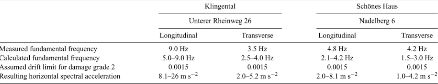
The few extant buildings that still reflect their original, pre-earthquake design were systematically screened. Two structures
Table 3. Calculated horizontal spectral accelerations corresponding to grade 2 damage for two masonry buildings that survived the earthquake with no major damage.
Klingental Sch¨ones Haus
Unterer Rheinweg 26 Nadelberg 6
Longitudinal Transverse Longitudinal Transverse
Measured fundamental frequency 9.0 Hz 3.5 Hz 4.8 Hz 4.2 Hz
Calculated fundamental frequency 5.0–9.0 Hz 2.5–4.0 Hz 2.1–4.2 Hz 1.5–3.0 Hz
Assumed drift limit for damage grade 2 0.0015 0.0015 0.0015 0.0015
Resulting horizontal spectral acceleration 8.1–26 m s−2 2.0–5.2 m s−2 2.0–8.1 m s−2 1.0–4.2 m s−2
(‘Klingentalkloster—Dormitoriumsfl¨ugel’ Unterer Rheinweg 26, ‘Sch¨ones Haus’ Nadelberg 6) show only minor modification to windows and entries in the last 650 years. We were able to estimate their seismic performance by using modern engineering techniques. Both present several positive conceptual features: a compact, sym-metric layout, thick continuous walls, relatively stiff wooden floors with massive beams and a rigid basement. The quality of the natu-ral stone masonry was judged clearly above average for both. These buildings probably suffered only minor damage (damage grade 1 or 2) since no traces of repaired cracks could be found in their walls and wooden floors, and their roofs were dated to pre-earthquake time. Ambient vibration measurements were performed to deter-mine the fundamental frequencies of the building vibrations in both principal horizontal directions (Table 3). The measured frequen-cies are characteristic for very low amplitude vibrations before the onset of masonry wall cracking and can be considered an up-per bound for the stiffness during real earthquake shaking. With growing cracks, the wall stiffness will typically be reduced by at least a factor of 2 (Eurocode 8-1, 2004). Assuming a range of possible material properties, we confirmed the measurements by simple linear structural analysis. The drift limit corresponding to damage grade 2 was estimated to be in the range of 0.001–0.002, corresponding to typical serviceability limits in building standards for the earthquake-resistant design (Eurocode 8-3, 2005). Given building height and drift limit, we calculated resulting horizontal spectral displacements in the fundamental mode following the in-verse procedure of displacement-based seismic design (Priestley
et al. 2007). The obtained horizontal spectral displacement was
then transformed into the dynamically equivalent horizontal spec-tral acceleration of the single degree-of-freedom system. This cor-responds to the fundamental mode (Table 3). Agreement between measured and calculated fundamental frequency is better for the ‘Klingental’ building that presents a simpler geometrical layout than does ‘Sch¨ones Haus’. The values in Table 3 consider only the in-plane resistance of the masonry walls. We expect that the weakest point would be the out-of-plane behaviour of the walls parallel to the timber floor beams, resulting in somewhat lower acceleration values.
Table 3 shows the results from the simple linear dynamic anal-ysis: the two buildings could have survived an earthquake shaking with spectral accelerations up to 4 or 5 m s−2 corresponding to intensity VIII or IX without major damage. This broad range of intensity (VIII–IX) results from the choice of ground-motion to in-tensity relation to be applied (Wald et al. 1999; K¨astli & F¨ah 2006). We therefore cannot eliminate this level of shaking during in the 1356 event. On the other hand, it is neither possible to estimate lower bounds for the shaking nor to deduce an intensity value from analysing only these buildings.
2.3 Historical and archaeological investigations of the quake area
Distribution of data on the quake area is somewhat dispersed. Apart from direct information about what happened on October 18, we relied on indirect data about the reconstruction of buildings. Below we provide a compilation of sites with earthquake data that we gathered from historical and/or archaeological sources. We sought a robust data set to assign macroseismic intensity.
Wider Basel area
For the surrounding areas, archaeology offers modest information on some castles and churches. As was mentioned earlier, several castles were partially or completely destroyed by the event. However, only in a few cases, archaeological evidence was supported by historical records.
The most consistent data underlining this hypothesis come from sites where both written and archeological evidence was found. Prat-teln (BL), a small town east of Basel, with its castle Madeln, is one of these examples. During an excavation of Madeln, a large quan-tity of valuable objects was recovered from the debris, including two great helms, a tin plate and many weapons that could be dated around the year 1350. Heavy damage to the castle is very probable given this large number of metallic objects and to the fact that parts of the masonry had collapsed as an entire unit. No reconstruction occurred. The destruction of Madeln is confirmed by the ‘Pratteler Kundschaft’ (StABL: Urkunde 537) and the ‘Eptinger Hausbuch’ (Christ 1992) even though the records lack specifics about the de-gree of loss. A second building at this site, the ‘Weiherhaus’, was destroyed as well, but restored later (Meyer 1981; Christ 1992).
From a large number of metallic objects found during an excava-tion of Castle ‘Bischofstein’ at Sissach (BL), its rapid destrucexcava-tion can be assumed. Among other objects, a brass pan was found. These evident signs of rapid destruction indicate that an abrupt incident— not a slow breakup—occurred. Scholars point to the 1356 event (Tauber 1980; Meyer 1981; Wild 2006). For Castle ‘Waldeck’ (Ley-men, F) the most spectacular object recovered was a large bronze cauldron (Meyer 1981, 2006; Wild 2006). A deed of 1379 implies that the bishop of Basel proposed rebuilding the Castle Waldeck after the earthquake, when he was eager to leave the castle as a legacy (Trouillat 1861).
A further example of heavy damage is Castle ‘Angenstein’ in Duggingen (BL), mentioned within the ‘Burgennamenliste’ (Bernoulli 1890). Archaeological evidence shows the collapse and rebuilding of the complete northwestern wall of its donjon (Meyer 2006; Wild 2006). Some wooden beams used in the newly built part could be dated by dendro-chronology to 1364 (Gutscher 2005).
However, no written evidence could be found to support this interpretation. The same holds true for the castles ‘Wildenstein’ in Bubendorf (BL) and ‘M¨unchsberg’ in Pfeffingen (BL), both mentioned in the ‘Burgennamenliste’. Archaeological excavation at Bubendorf indicated severe damage (Tauber 1980) even though no written evidence exists to support this theory. For the church of Muttenz (BL), evidence of building activities in the mid-14th cen-tury is known (Ewald 1998; Meyer 2006; Wild 2006). A document from the mid-18th century refers to historians of former centuries (Bruckner 1748) who describe the collapse of Castel ‘Wartenberg’ at Muttenz (in fact this was a group of three neighbouring castles). No contemporary record could be found and no archaeological evi-dence supports this hypothesis so far. Wartenberg as well as Castle Farnsburg in Buus (BL) was known to be inhabited after the earth-quake, thus damaged but not destroyed. Archeological findings have shed no further light (Wild 2006).
Rebuilding activities are also known for the ‘Church St. Mar-tin’ near Rheinfelden (AG), approximately 10 km east of Basel. The top floor of its tower had to be refurbished and we know from dendro-chronological dating that this happened in 1361. Since the church was so new, having been consecrated in 1352, such rebuild-ing might indicate earthquake damage (Frey 2000; Frey & Redrebuild-ing, unpublished data; Wild 2006). Two historical records from the 15th century note support given to the city of Basel by neighbouring towns, including Rheinfelden. [Others were the Alsatian villages of Strasbourg, Colmar, Schlettstadt and Mulhouse as well as Freiburg im Breisgau and Neuenburg (D) (Stierlin & Wyss 1819; Burkart 1909).] Such aid capability implies less damage in those donor regions.
The restoration of the church of the Olsberg Monastery at the time might hint at partial earlier destruction. Courvoisier & Sennhauser (1990) suggest linking this restoration to the 1356 event. Others though disapprove this assumption (Frey & Reding 2006). For the St. Gallus Church in Kaiseraugst (AG), new construction horizons for the top floor of the church could be dated to the time shortly after 1356. This was equally true of the bell-tower for the years 1368/1369 (Kontic 2006). Here, we rely on dendro-chronological dating and archaeological findings only.
No archaeological investigation has been carried out yet for ‘Schauenburg’ Castle at Frenkendorf (BL). It was supposed to have suffered damage from the Basel earthquake but was inhabited until 1502 (Wild 2006). Nor is much known about the site of Riehen (BL). A chronicle of the 18th century blames the destruction of the church there on the quake, and in fact, the church bell dates from 1357 (Iselin 1923). No contemporary document is at hand, though. Indications of possible building activities after the event can be found in the ‘St. Alban Zinsbuch’ of 1369 (StABS: St. Alban E fol. 37) for the village of Gelterkinden (BL). The document mentions the reduction of interests (‘Zinsreduktionen’) due to the tremor.
Regions of Bern, Solothurn and Aargau (south of the epicentral area)
For the town of Bern, the town clerk and chronicler Konrad Justinger
(†∼1425) is a rather reliable source on the 1356 event. In the
chroni-cle of 1421 (Stierlin & Wyss 1819, Feller 1974), he mentions a crash of the tower and choir of the Leutkirche, as well as fissures in walls of other buildings in Bern. Refurbishing one of the two towers of ‘Grasburg’ Castle in Wahlern (BE), situated roughly 85 km south of Basel, was traced to the 1356 event (Burri 1935; Wild 2006). Con-temporary accounts provide evidence for the purchase of material to reconstruct the top of the donjon as well as the wall’s perimeter
and unmistakably blame the quake (Burri 1935). A contemporary record in the Fontes Rerum Bernensium (1903) also notes construc-tion of a new tower for ‘Leutkirche’ in 1359 April 29, after its great annihilation (Howald 1872). A similar account is to be found in an edited chronicle by Etterlin of the 15th century (Gruber 1965) as well as in Schodoler’s manuscript of 1525 (StiBib. Eins.: Ms. No. 384). No archaeological evidence exists for this site so far.
In the town of Solothurn, geographically situated between Basel and Bern, reconstruction of the steeple of the main church, built around 1300, was undertaken shortly after the 1356 quake. A chron-icle of the late 18th century, composed by the cantor Franz Jakob Hermann mentions damage in Solothurn due to the event (ZSO: Ms. S II 18). Unfortunately, he did not give any quoted sources. Later compilers pursued this assertion (Winist¨orfer 1855; Amiet 1865; Sennhauser 1990). And indeed, a building contract dating from the year 1360 to erect a new spire for the St. Ursen Church sup-ports this statement (StASO: Urk. 1360; Solothurner Wochenblatt 1816). There is no indication in this document, however, of why the spire was rebuilt, the entry thus remaining fairly vague.
Construction work at ‘R¨ot(t)eln’ Castle near Kaiserstuhl (AG) reports high costs in the year 1359. The available record does not, however, justify strongly attributing such activities to seismic dam-age (GLA: Ms. 5 Conv. 548. Perg. REX II 5462, 5453). Thus, it has not been integrated in our assignment sample. For the same reason, we omit alleged devastation reported for the town Zofingen (AG) in ‘Frikart’s chronicle’ (Frikart 1811), as well as archaeological in-dications for quake damage to the bell towers in Rodersdorf (SO) (Loertscher 1957). Both hints offer no direct indication of whether they can be linked to the event. They consequently have not been assigned for our purposes.
By contrast, there is a very reliable entry in an Austrian deed, concerning the fates of the subjects in the Aargau, then under the Habsburg rule (Thommen 1899; Merz 1905). This record notes that ‘Homberg Castle’ in Wittnau (AG) was almost completely destroyed by the quake. Renovation was projected and partly carried out but never finished. Valuable objects found under its debris support this entry (Reding 2000; Wild 2006).
Jura region
Indication of earthquake damage was also found for ‘Valdegrani’ Cloister at Moutier-Grandval (BE) in the Swiss Jura. Heinrich of Rebdorf (†1364) mentions in his chronicle the complete devastation of the monastery (Boehmer 1868a). However, we note his obvious exaggeration; he speaks of mountains that should have exchanged sites, and 2000 people dead. Seismic damage, however, is supported in part by a Basel deed, describing the consecration of an altar in 1361 (Trouillat 1861). This entry nevertheless remains somewhat vague.
In the 17th century, the chronicler Buchinger (Buchinger 1666; Walch 1950) mentions that the church of the ‘Lucelle’ Monastery near Pleigne (JU) was rebuilt in 1346 due to a strong earthquake. This difference of a decade is most likely a scribal error for 1356. Since the monastery was later given as a legacy, it is most probable that its damage was limited (Trouillat 1861).
The alleged destruction of ‘Soyhi`eres’ Castle at Soyhi`eres (JU) is erroneously taken as having been complete. The entry in Trouillat (1858) dating to 1337 was later incorrectly taken as the testimony of a total loss from the earthquake (Helg 1970; Meyer 1981). However, as Quiquerez (1863) states, the castle was damaged only marginally. Since we do not have any earlier records of this account, the finding is uncertain.
Del´emont (JU) is supposed to have been damaged, since the Vorbourg Castle (consisting of two buildings and inhabited by the Telsperg family) and local dwellings are said to have been damaged (Helg 1970; Daucourt 1980; Wild 2006).
Alsace
The entire Alsace is said to have been affected (Bib. Mun Col.: Ms No. 503). Most likely, the seismic event was felt in Colmar (Bib. Mun Col.: Ms No. 349) even though the record is imprecise as it was for Strasbourg (Rasch 1591; Dietler 1898). The contemporary witness Fritsche Closener notes that the intensity of the 1357 event in Strasbourg was remarkably stronger than that of 1356 October in Strasbourg (Closener 1870). For Strasbourg and the 1357 event, an intensity VII is estimated.
A most interesting statement in a Swiss deed concerns the monastery at Blotzheim (8 km in the northwest of Basel): it explic-itly negates the habitability of the buildings after the 1356 earth-quake (Boner 1945). We thus conclude that damage to the buildings was rather strong.
Damage to ‘Morimont/M¨orsberg’ Castle at Oberlarg has been documented by a number of chronicles (Trouillat 1861; Walch 1950; Reinhard 1965). However, since they are not contemporary, their entries remain somewhat suspect. Archaeological investigation has not been more specific; we are not yet certain of what occurred at the castle before and after 1356. Although it is well known that the fort was given as a feud in 1361 (Trouillat 1861), this does not clarify its grade of damage or possible preservation (Biller & Metz 1989; Wild 2006). Unfortunately, a full renewal of the fortress in the 16th century erased any chance of tracing the history of the old castle.
Figure 9. Picture of R¨otteln Castle close to L¨orrach (Schomann, unpublished data). See noticeable repairs on its eastern side (see arrow). Documents providing reasons for the repair do not exist.
The same holds true for the church at Oltingue: despite the fact that archaeological indications for earthquake damage have been found (Schweitzer et al. 1990; Munch-Armengaud 2005, personal communication), a decisive connection to the 1356 earthquake can-not be made. Also ‘Blochmont’ Castle at Kiffis (Trouillat 1861) was given as a feud. It is most likely that this castle was destroyed and rebuilt (Meyer 1981).
Furthermore, the earthquake was felt at the nearby site Montb´eliard (Duvernoy 1832).
Southern Germany
Information for Southern Germany is scarce and unspecific: note the collection of records by Mone (1848). The paucity of historical and archaeological findings for this region might result from archival difficulties: documents of the diocese Konstanz and of Monastery Sankt Blasien are scattered over several archives, or they note only minor effects of the Basel quake in this area. Contemporary docu-ments are absent also for the donjon of ‘R¨otteln’ Castle at L¨orrach (D), 10 km north-east of Basel, although its eastern side shows no-ticeable repairs (Heimgartner 1964; Schomann, unpublished data) (Fig. 9). Other records mentioning perceived earthquake effects at the site are neither contemporary nor reliable in origin (Holdermann 1903; Seith 1954; Moehring 2001).
The famous Konstanzer Weltchronik (BSB: Cgm 426) mentions an earthquake in 1356 in Konstanz (D), without going into detail; it is possibly based upon ‘Heinrich of Diessenhofen’, a contemporary witness. Diessenhofen reports one huge shock and several fore-and aftershocks occurring on 1356 October 18 fore-and the day after at Konstanz (B¨ohmer 1868b) (see Table 1). Of damage he speaks about Basel itself; it is most likely that Konstanz did not experience
any. However, since Diessenhofen presumably did not reside in Konstanz at the time of the event (Hotz 1994, 2005), this record is not as reliable as we hoped. Two fund-raising appeals for the ‘Basel Cathedral’ are verifiable in the diocese of Konstanz: the first in November 1356 (Wackernagel 1856), the second in July 1364 (StABS: Domstifturkunden, No. 130), each with the promised indulgence of 40 days. Again, this donor capability indicates minor damage in the respective towns and regions, as did donations for the city of Basel by neighbouring towns (Stierlin & Wyss 1819) mentioned above. The third part of the project ‘Die Burgen im mittelalterlichen Breisgau’ at the University ‘Freiburg im Breisgau’ might shed light on open questions for Southern Germany (Zettler & Zotz 2003, 2006).
Wider quake area
In the early 20th century, historian Ernest Petit (1905) compiled a selection of sources of roughly 15 Burgundian locations affected by the earthquake. Since most of them seem to be contemporary, they have to be considered, even though the collection of damaged sites first evokes some irritation. Many of them consist of accounts of necessary repairs of parts of the castles, reported by the respective lords of the castles or manors (‘Guillaume’).
The most interesting trace is the one given for Montrond-le-Chˆateau, where both the foreshock at around 5 pm and the main shock at 9 pm are described. The tower of the castle is reported to have collapsed. Of Besanc¸on it is said that the tower of ‘Vayte’ was destroyed. And indeed, the Konstanzer Weltchronik (BSB: Cgm 426) also states that the tower of a church collapsed at Besanc¸on. At Dijon, a wall connecting two castles was shattered and several building roofs had to be repaired (ADCO: B 1402; ADCO: B 1405, Petit 1905). At Avallon, it has been said that two city portals as well as many chimneys were cracked. At Montbard, the rebuilding of the roof of a castle is accounted as well as a couple of chimneys that were either damaged or destroyed (ADCO: B 5306; Petit 1905).
At Montr´eal, the repairs required were even more serious: walls, portals, crenellates and also towers had to be restored. Required reparation is also reported for Chˆatillon-sur-Seine, even though no further detail of specific damage is given. Portals had also to be rebuilt at Flavigny, and at Montcenis a wall with a rather large cleft had to be renovated. At Beaune, several clefts in the walls as well as of one of the portals were requested for restoration. And lastly, for the towns of Semur, Lantenay, Aisey and Maisey-le-Duc, repairs were stated even though the records lack details.
Yet, why should there be effects this far away from Basel (some 300 km due west), when regions such as the Alsace were damaged only slightly? Petit himself claims that this destruction might be traced due to bad weather conditions during this period; however, most contemporary sources cite the 1356 October earthquake. Con-temporary records for Paris and Reims (G´eraud 1843) unquestion-ably support the postulation that the event was widely felt. Nonethe-less, the findings for the Burgundy remain somewhat opaque. Even though most unlikely, a potential hypothesis of a local damaging earthquake in the Burgundy on the day of the Basel event or other reasons for the reported damage should be further investigated.
One last remark concerns the town of Speyer, roughly 200 km north of Basel. On 1356 November 11, the town council decreed a modesty regulation about clothes (‘Kleiderordnung’) to appease the anger of God made visible by earthquakes (Eisenbart 1962). The chronological proximity of this decree to the 1356 October earthquake implies that it was felt at this site.
3 PA L A E O S E I S M O L O G I C A L R E S U L T S R E L AT E D T O S E C O N D A RY
P H E N O M E N A
Damaged speleothems in caves (Lemeille et al. 1999; Lacave et al. 2004) and numerous triggered rock-falls that date to the time of the Basel quake (Becker & Davenport 2003) have been recognized as possible secondary phenomena in the epicentral area. There, Sch¨urch & Becker (2005) studied some blocks along the edges of cliffs that appeared very unstable with respect to ground motion. They applied the precarious rock method proposed by Brune (1996, 1999) to seven blocks of which, according to Brune’s definition, two are precariously balanced. Their peak toppling accelerations are slightly lower than about 3 m s−2. Two (or three) further blocks are possibly semi-precarious. If we assume that most rocks with toppling accelerations smaller than 3 m s−2 were triggered during the 1356 event, this acceleration value provides some bound for the ground motion of the 1356 event. As discussed by Sch¨urch & Becker (2005), the large uncertainty of estimated ground motion values is related to possible near-source effects, local site conditions and the method used. According to Brune & Whitney (2000), macroseismic intensities of VII in the MM (Modified Mercalli scale) scale would probably have toppled most precarious rocks. Those with intensity VIII MM would have toppled all. Due to the similarity of modern macroseismic scales, similar intensity values can be assumed in the EMS scale. The sites of the studied cliffs are located in flat-lying, thickly bedded upper Jurassic coral limestone, for which we expect intensity values lower than those at soft-sediment sites. However, as indicated by Anderson & Brune (1999), topographic effects may play a role and the problem becomes very site specific. For the Basel area, no complete statistical evaluation of the toppled and the non-toppled precariously balanced rocks is available. Information from these investigations was not transformed into a macroseismic intensity point.
Lacave et al. (2004) proposed ground motion estimates for two near-surface caves at about 5 km and 40 km from the fault. For the closer cave (B¨attlerloch, Zwingen), they estimated peak ground acceleration (pga) with 10 m s−2to explain the complete breaking of a stalactite group. This value is a worst-case estimate, accounting for the most unfavourable hypothesis concerning the initial, intact length of the broken stalactites. However, as pointed out by the authors, the breaking of the stalactites might have originated in a strong flood, not the earthquake. Information was not transformed into a macroseismic intensity point.
For the more distant ‘Milandre’ (Boncourt) cave, they estimated the pga between 0.5 and 2.5 m s−2, with an upper limit in the range of 2.5–4 m s−2. That limit corresponds approximately to the intensity range VIII to IX, depending on which ground-motion to intensity relations are applied (Wald et al. 1999; K¨astli & F¨ah 2006). Other reasons for the broken stalactites are also possible at this Milandre site. Archaeologically observed cracks in the walls of the nearby Chˆateau De Milandre were most probably due to the earthquake (Wild 2006). The castle was inhabited until the 15th century at least. For the macroseismic assessment, weight was given only to the archaeological information.
Investigations of lake deposits in the Basel area (Becker et al. 2002) revealed several earthquake-induced structures that could have been caused by prehistoric events. The effects of the 1356 earthquake, however, were not visible in the geological archive due to unfavourable conditions in lake sedimentation during that time. Human activity in the following centuries may also have obscured such effects. Soft-sediment deformation (liquefaction) in lake
deposits could, however, be identified about 60 km from the epi-center in Baldegger Lake in Central Switzerland (Monecke et al. 2004). The data were taken at two borehole locations and include 13 sediment cores from the deepest part of the lake. Small-scale deformation structures were observed in two cores. In one, the sand forms a mushroom-like structure protruding into the carbonate mud. In a second core, lenses of carbonate mud are sunk into the clastic material. Furthermore, slight disturbances in the layering and dis-rupted layers occur below the clastic stratum. These structures are interpreted as earthquake-induced soft sediment deformations with mushroom-like intrusions and pseudonodules. Such deformations may indicate the passage of the 1356 seismic waves. According to Monecke et al. (2004), lake sediments are only affected if they are situated within an area that underwent ground shaking not smaller than intensity VI to VII. The authors conclude that the Baldeg-ger Lake might have experienced a movement equivalent to this macroseismic intensity range.
The slightly more distant lakes (Vierwaldst¨attersee, Seelisberg Seeli) show no such deformation and no sub-aquatic landslides, so a macroseismic intensity in the range V to VI or lower can be assumed for that region. Monecke et al. (2004) conclude that only intensity V was reached in the Vierwaldst¨attersee and Seelisberg Seeli. An intensity of VII is the threshold for multiple sub-aquatic landslides in these lakes (Monecke et al. 2004; Strasser et al. 2006) and they have been identified for several past events. Previous studies iden-tified numerous mass-movement deposits related to the Mw 6.2 earthquake of 1601 in central Switzerland (e.g. Schnellmann et al. 2002, 2006). For that event, the intensity was VII in the Lucerne area (Lucerne is located at the western border of the Vierwaldst¨attersee) (Schwarz-Zanetti et al. 2003).
For the Lucerne area, palaeoseismological conclusions related to the 1356 event are supported by a contemporary description from Lucerne in the ‘Burgerbuch’ (dated 1357), which, however, lacks reports of damage (Wackernagel 1856). The record of the earth-quake in the Annales S. Blasii et Engelbergenses (1861), recorded in Engelberg (OW), allows us to assume that it was widely felt in this region.
For the Lake of Zurich, two mass-flow deposits in its western part (close to the villages Kilchberg and K¨usnacht) could be dated to 590–700 cal yr BP (1250–1360) and might coincide with the Basel earthquake (Strasser et al. 2006; Strasser 2008). These deposits are partly related to slope failures along lateral deltas where threshold stabilities might be low (Strasser 2008). Delta slopes may have been additionally ‘charged’ or even triggered by the historically documented flooding event in 1342 (Schwarz-Zanetti 1998). At its site by the western end of the lake, Zurich was one of the larger cities in the 14th century. In terms of significant damage, the two versions of the Zurich chronicle (Henne 1861; Gamper 1984) mention the event for Basel but not for Zurich. Thus, an intensity of V to VI can be assumed for the latter city and its surroundings.
4 M A C R O S E I S M I C A N A LY S I S
All information from the different historical and archaeological findings was collected in a database of the Swiss Seismological Service and analysed formally. This analysis was performed by a designated working group who took into consideration the time elapsed between an event and its description. Then, given the doc-ument’s function, the author’s intention in producing the record, the overall context of the document and the available archaeological information, single reports were rated for their reliability.
Macro-seismic intensity in the EMS-98 scale was assigned by settlement, using all sources of information about effects to buildings within it. Depending on the intensity-relevant content of the reports, the project group assigned a most probable intensity and a range defined by the minimum and maximum probable intensities.
The assignments were tagged with a quality estimate representing the reliability, independence and diversity of the summed informa-tion sources concerning one site and its earthquake-relevant content. The quality is defined within a 5◦scale that ranges from ‘very good’ to ‘very poor’ in accordance with previous investigation of historical Swiss quakes (F¨ah et al. 2003).
All macroseismic intensity points in this study received the two lowest qualities (poor, very poor), except for the city of Basel where we assigned the second highest quality: ‘good’. The macroseismic points are given in two tables. Table 4 provides the reliable inten-sity data points, derived from contemporary information, whereas Table 5 provides the uncertain ones, derived from secondary ev-idence. Fig. 10 illustrates the site points derived from historical, archaeological and palaeoseismological information. The most re-liable site point is for the city of Basel.
The castles from the lists (‘Burgennamenliste’) are not given in Table 5, because these lists are not contemporary and, according to Lambert et al. (2005), sometimes wrongly located. Different authors (see Lambert et al. 2005 for a summary) have used the castles listed in the ‘Burgennamenlisten’ for macroseismic assessment. Lambert
et al. (2005) is the most recent study, it suggested some locations
for castles unlike those used by other authors. However coordinates are not provided in his study. Lambert et al. assigned intensity of VIII to all the castles and intensities of VIII or IX to Liestal and Basel.
Finally, we estimated the epicentral location and magnitude of this event. It was last assessed during the revision of the Earthquake Catalog of Switzerland (ECOS02) (F¨ah et al. 2003, Swiss Seis-mological Service 2008) and relied mostly on the macroseismic field published in Mayer-Rosa & Cadiot (1979). ECOS provides a uniform estimate of the moment magnitudes Mw for all historical and instrumental events. The historical events were then assessed following the proposal of Bakun & Wentworth (1997). This uni-form earthquake size estimate in terms of magnitude required a magnitude/intensity calibration based on a calibration data set of earthquakes in the 20th century for Switzerland and adjacent areas (F¨ah et al. 2003). A distance weighting function is used, with ob-servations at near distances preferentially weighted to improve the resolution of the epicentral region. The weight is zero for distances larger than 200 km. F¨ah et al. (2003) proposed two attenuation re-lations, one for shallow events (∼0–7 km depth) and one for deep events (∼8–20 km depth). For any event with a magnitude larger than 5.5, the relation for deep events was selected for calibration. The formerly estimated moment magnitude Mw of the 1356 event was given as 6.9, with an error bound of 0.5 units. One problem in assessing the magnitude was the fact that the Basel event was outside the magnitude range of the calibration events. Additionally, the cumulative effects of damage in the epicentral region due to fore-, main- and aftershocks could not be separated. The estimated magnitude is therefore uncertain.
We applied a procedure identical to F¨ah et al. (2003) for the new macroseismic field, based on a model tree with three branches:
(a) Calculation based on the more reliable intensity data points given in Table 4, equally weighted;
(b) Calculation based on all available intensity points (Tables 4 and 5), equally weighted;

![Figure 2. Geographical map of the area of Basel published in 1880 [Schumacher 1878/1880; coordinates: Swiss National Grid in (km)], and representation of the city of Basel in 1615, seen from the North (Merian 1615)](https://thumb-eu.123doks.com/thumbv2/123doknet/14910816.658422/3.918.163.781.70.673/figure-geographical-published-schumacher-coordinates-national-representation-merian.webp)