Publisher’s version / Version de l'éditeur:
Canadian Geotechnical Journal, 3, 4, pp. 191-203, 1966-11-01
READ THESE TERMS AND CONDITIONS CAREFULLY BEFORE USING THIS WEBSITE.
https://nrc-publications.canada.ca/eng/copyright
Vous avez des questions? Nous pouvons vous aider. Pour communiquer directement avec un auteur, consultez la
première page de la revue dans laquelle son article a été publié afin de trouver ses coordonnées. Si vous n’arrivez pas à les repérer, communiquez avec nous à [email protected].
Questions? Contact the NRC Publications Archive team at
[email protected]. If you wish to email the authors directly, please see the first page of the publication for their contact information.
NRC Publications Archive
Archives des publications du CNRC
This publication could be one of several versions: author’s original, accepted manuscript or the publisher’s version. / La version de cette publication peut être l’une des suivantes : la version prépublication de l’auteur, la version acceptée du manuscrit ou la version de l’éditeur.
Access and use of this website and the material on it are subject to the Terms and Conditions set forth at
Downslope soil movement at a sub-arctic location with regard to
variations with depth
Williams, P. J.
https://publications-cnrc.canada.ca/fra/droits
L’accès à ce site Web et l’utilisation de son contenu sont assujettis aux conditions présentées dans le site
LISEZ CES CONDITIONS ATTENTIVEMENT AVANT D’UTILISER CE SITE WEB.
NRC Publications Record / Notice d'Archives des publications de CNRC:
https://nrc-publications.canada.ca/eng/view/object/?id=456dcb65-814a-4611-8b65-23735e116abb https://publications-cnrc.canada.ca/fra/voir/objet/?id=456dcb65-814a-4611-8b65-23735e116abbDOWNSLOPE SOIL MOVEMENT
AT A SUB-ARCTIC LOCATION WITH REGARD TO VARIATIONS WITH DEPTH
Soil lllovements resulting from solifluction or similar processes have been investigated at Schefferville, P.Q., Canada, where the variation of movement with depth below the surface was specially considered.
Tubes up to 2 m long were inserted vertically in the ground and their subse- quent defoimation (if any) measured with special probes, which passed down the tubes in sitzc. Some sites proved to be en- tirely stable despite vegetational charac- teristics that might have been related to disturbance. Movements at the surface of more than 10 cm/yr. were recorded on a 20" bare slope covered with small stones. Similar large movements were recorded on a lobate terrace-like feature with a general 8 to
l o o slope. The distribution of
movement with depth was such as to pro- duce a typically concave downslope form in the tubes. The movements varied in in- tensity and from year to year; they decreased with depth, and were not measurable below about 1 m. Although they are similar to those observed by Rapp and others, they are remarkable in view of the slight slope on which they occurred. Analysis shows that consolidation following frost heave is probably riot the sole cause. A stability calculation of the type commonly used for engineering urposes would have given no indication o?
the occurrence of movements of the magnitude observed. They might have been suspected, however, from geo- morphological considerations of the origin of the surface features of the affected area.On a ktuclie les mouvements du sol causis par la solifluction et par cl'autres pl16nomhnes semblables h Schefferville, P.Q., au Canada, et on a apporte une attention particulibre aux variations des mouvements par rapport B la profondeur.
Des tubes ayant jusqu'8 2 n~btres de longueur ont etb enfonces verticalement dans le sol et leur diformation subsequente (s'il y en avait une) a kt6 mesurke au moyen de sondes speciales que l'on intro- duisait dans les tubes in situ. A certains endroits, malgrk des caractiristiques de vegetation qui laissaient supposer un certain dkrangement, on a constate que le sol etait complhtement stable. On a enregistre des mouvements dkpassant 10 cm/an sur une pente nue ayant un angle d'inclinaison de 200 et couverte de petites pierres.
On a constate des mouvements aussi considerables sur un terrain lobaire en forme de tenasse ayant un angle de declivite de 8 8 10". Les mouvements variaient selon la profondeur de telle fason qu'ils diformaient les tubes et leur donnaient une forme de pente descendante typiquement concave. Les mouvements variaient 6 alement en in-
G
tensite et d'une annee A lautre ; ils di- minuaient avec la profondeur et il 6tait impossible d e les mesurer B une profondeur dkpassant environ 1 mbtre. Bien qu'ils soient semblables a ceux qu'ont observe Rapp et d'autres chercheurs, ils sont remarquables en raison de la pente peu prononcke du terrain ou ils se sont produits. Une analyse montre la consolidation qui suit un godement fi au gel n'est pas la seule cause de ces mouvements. Un calcul de stabilite du type de ceux que les ingenieurs eEectuent com- munkment n'aurait pas permis de pr6voir l'esistence de mouvements tels que ceux que I'on a remarques. Toutefois, on aurait pu !es soupGonner gr2ce h des considkrations giomorphologiques sur I'origine des caract6- ristiques de terrain de la region.Descriptions of surface features indicative of downslope movements of soil material due to frost action, known generally as solifluction, occur frequently
'Research Officer, Snow and Ice Section, Division of Building Research, National Research Council, Ottawa.
191
192 CANADIAN GEOTECE~'ICAL JOURNAL
in the geological and geomorphological literature of the arctic and sub-arctic regions. Increasing construction and development in these regions has led to more detailed studies, stimulated by the importance and unusual nature of these natural soil movements as an occasional engineering problem. Measure- ments of the surface displacement associated with frost action have recently given a clearer understanding of the magnitude of such movements and of the character of the associated surface features (Rapp, 1961). With few exceptions (e.g., Rudberg, 1962) the distribution of the movement below the surface has not been investigated. An instrument has been constructed for this purpose, based on an earlier type (Williams, 1957a) which was substantially developed and m o d s e d for the present investigation. It involves insertion of polyethylene tubes of %-in. (1.59 cm) internal diameter, %-in. (0.33 cm) wall thickness, and up to 2 m in length into the ground, and subsequent investiga- tion of their shape, in situ, by insertion of a special probe. The probe consists basically of a curvature-sensing element using electrical resistance strain gauges. The instrument is fully described elsewhere (Williams, 1962).
Most investigations described in the literature have been carried out at sites where movement had apparently taken place. The present investigation includes sites where the occurrence of movements was not immediately obvious.
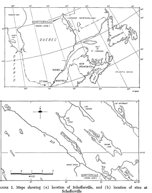
Sites were investigated in the region of Schefferville, P.Q. (Figs. la, l b ) , in areas with mean annual temperatures of 22 to 23"
F1
(-5 to -6' C ) , wherepermafrost occurs discontinuously. The active layer extends, in general, 1.5 to 3 m ( 5 to 10 ft.) deep.
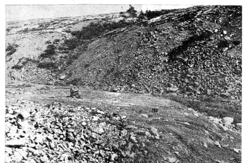
Site 1, approximately 20 krn (12 miles) northwest of Schefferville, is a conspicuous and unusual "terrace" or "lobe-like" feature (Figure 2 ) . Six tubes 1.5 to 2 m ( 5 to 7 ft.) in length were placed as shown on the plan (Figure 3 ) . The terrace surface had a slope of 4 to go, but the bluff was much steeper
(Figure 3 ) .
Site 2 is a slope, varying from 5 to 23' (Figure 4 ) on the east side of Dolly Ridge approximately 5 krn ( 3 miles) northeast of the townsite and covered with alder scrub with isolated spruce (Picea glnucn), except for patches of grass and moss. Throughout much of the slope, bedrock lies 1 to 2 m below the surface. The woody vegetation shows considerable deformation similar to that sometimes associated in temperate regions with soil movement. Water reaches the surface at the foot of the slope and Betub nana is also present there. Siu tubes 0.4 to 1.2 m (16 to 48 in.) in length were placed at various points between the foot and the top of the slope in positions with the types of vegetation cover noted above.
Site 3, which is about 300 m southeast of Site 1, is a vegetation-free slope of about 20" (Figure 4 ) covered with small stones.
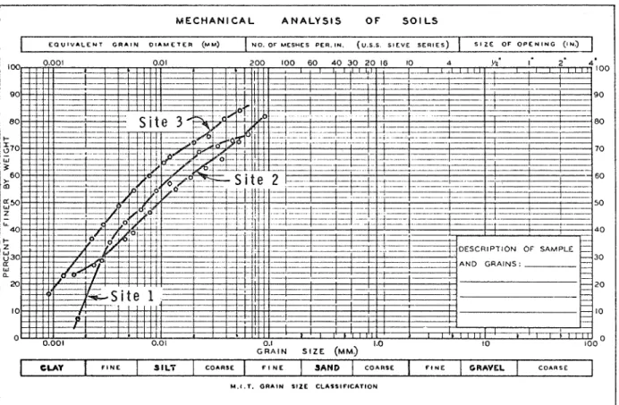
Grain-size composition curves for samples from the three sites are shown in Figure
5.
IExtrapolated from the mean annual temperature of 24.2" F (4.4" C ) measured at the townsite, which is at 200 to 500 feet lower.
WILLIAMS: DOWNSLOPE SOIL M O V ~ T 193
FIGURE 1. Maps showing ( a ) location of Schefferville, and ( b ) location of sites at Schefferville
Tubes were inserted vertically in holes prepared with an auger (Sites 1
and 3 ) or with a portable pneumatic drill (Site 2, where stones prevented
use of the auger). The augered holes were only a few centimetres larger in
diameter than the tubes. During placing, the tubes were stiffened by insertion of a brass or wooden rod, which was removed after the holes had been back- filled with a mud slurry. The tubes were heat sealed at the base and closed with corks at the tops.
194 CANADIAN GEOTECHNICAL JOURNAL
FIGURE 2 . Site I. The slope investigated is in the foreground where the author is sitting. An assemblage of large boulders lies upslope of this and bedrock appears at the surface
of the valley side not seen in the photograph
T
SITE 2-
+-
+ C f PROFILE 0-0, A Dt\
SlTE 3FIGURE 3. Layout of tubes at Site 1, based on linen tape FIGURE 4. Slope rofiles at Sites
2
measurements. The two slope profiles are based on accu- 2 and 3. Profile oes not include rate lcvclling. Vertical and horizontal scales are the same. locations of two of tubes atFIGURE 5. Grain size composition curves for the soils at the three sites. All the soils are susceptible to frost heave accord- ing to gcncrally accepted criteria (e.g., 13eskow, 1935)
M E C H A N I C A L A N A L Y S I S O F S O I L S
I
E Q U I V A L E N T G R A I N O I A M E T E R (MU) NO. OF M E S H E S P E R . I N . ( U . S . S S I E V E S E R I E S ) S I Z E O F O P E N I N G ( 4 ~ 3 200 100 60 40 30 20 16 I0 . . . , , . , . . . . . r t 1 . I I ' I I I ' 2 I I ' I I + - 1 1 ' * 1 1 1 1 1 1 - m- 1- r O ' "bl:ol ''
I ' " " I 0.01 0.1 1.0 10 G R A I N S I Z E ( M M ~ CLAY F I N E M . I . T . G R A I N S I Z E C L A S S I F I C A T I O N l A N D C O A R S E F I N E GRAVEL C O A R S EWILLIAMS: DOWNSLOPE SOIL MOVEMENT 197 0 T O P OF TUBE
.
\ T C ? Of l U 8 E I l l 1 0 0 TOP Of TUBEa.
OCiwnsLoPf-
GROUliO S U R F I C E7-
3
,In
-1.
-1.
g
D 3/8/61*'F
sented by the point symbols @,
w,
0, 0 ) were made on each tube (for further details see Williams, 1962) on the dates shown.abundant water may be unaffected by soMuction. It has since been shown that the deformation of woody vegetation at this site is caused by substantial creep movements within the thick snow accumulation during winter and
spring ( Andrews, 1961).
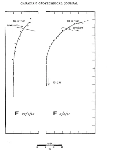
The movement that occurred at Site 3 is perhaps to be expected. The con- cave downslope form assumed by the tube (Figure 8 ) is similar to that generally shown by those at Site 1, where the slope angle is much less. The lower part of the tubes at Site 1 remained straight. When holes were augered in late August (for insertion of the tubes) frozen ground was encountered at about 1.5m ( 5 ft.). There can be, at most, only a short period of the year during which the ends of these tubes are in unfrozen ground, and it may be perennially frozen. As significant movements are unlikely in perennially frozen material, the lower ends of these tubes can be assumed to be £ixed p ~ i n t s . ~
2Recent work (Proceedings, International Conference on Permafrost, 1963) indicates that frozen pound at temperatures near 0" C and subject to seasonal temperature changes may show ' enomena. In the resent case, however, such movements would be much r m a l l e , ~ ~ ~ & s e observed in the Payer subject to total thaw.
CANADIAN GEOTECHNICAL JOURNAL
The concave downslope form assumed by the tubes shows that not only is the absolute displacement of the upper layers greater than that of lower layers, but the differential movement within each layer increases towards the surface. The slightly convex downslope form apparent in some of the tubes is probably due to their tendency to take on this form following transport to the site in a coil. Only certain tubes were taken from such a coil, and the tendency to assume a curved form seemed very slight at insertion. The convex down- slope form may also therefore be related to some corresponding movement of the soil.
The magnitude and profile of the movements and their irregular occurrence resemble certain of the observations of Rapp (1961) and Rudberg (1962), although the latter observations were carried out on much steeper slopes.
Possible causes of tlze movements observed at Site 1
Normal engineering analysis. When, for engineering purposes, it is necessary to determine whether movement will occur on a given slope, it is usual to make a calculation in which the forces tending to cause movement are com- pared with those that could be mobilized t o resist movement (i.e., the strength of the soil). Such computations take into account slope, water content, pore
WILLIAMS : DOWNSLOPE SOIL MOVEMENT 199
water pressure, friction angle for the soil, and other factors. Such a computa- tion was carried out for Site 1 (using the procedure in Janbu, Bjerrum, and Kjaernsli, 1956) and it indicated that for failure to occur the friction angle of the soil would have to b e considerably less than 30". The silty nature of the soil indicates that its friction angle is normally much higher. The calculation,
FIGURE 7. Shape of tube C at Site 1 revealed by excava- tion, August 1963. This can be compared with the instru- nlental observations for 1960 and 1961 in Figure 5. The grooves cut in the soil are a t 1 ft. (30.4 c m ) intervals.
furthermore, was made on the assumption that the soil was completely satu- rated at the time of movement. Even in the spring when there is abundant melt- water from snow, the soil is not, in fact, entirely saturated. The lower parts of the slope were observed to be substalltially drier when the upper parts were cnly appearing under the melting snow. Tensiometers inserted in the thawing ground showed that even in the most receiltly thawed soil somewhat negative pore pressures occur.
It should be noted that the eventual movements predicted by this kind of analysis involving development of slip surfaces apparently differ in nature from those observed. I t can be concluded that movements of this type are not
200 CANADIAN GEOTECHNICAL JOURNAL I I I I TOP OF TUBE DowNsLo~-&
./"
s'
I-1
i
P
.p
F 20/5/60 I l l 1FIGURE 8. Shape of tube at Site 3. For further explanation see Figure 5.
susceptible to conventional stability analysis, which in this case would have led to the conclusion that slope was completely stable.
Efiects of frost heave and subsequent consolidation. I t is frequently suggested that the volume changes associated with frost heave and subsequent consolida- tion are responsible for downslope movement (see, e.g., IVilliams, 1957b).
If it is assumed that frost heave occurs in a direction normal to the slope and that consolidation on thawing occurs vertically, then the downslope move- ment resulting from one freeze-thaw cycle is given by:
where L is the downslope component of movement
,B is the slope angle
E is the frost heave.
In Table I the vertical soil profile at tube C has been regarded as a series of layers 5 cm (1.97 in.) thick. The frost heave per year necessary (according to the above equation) to give the increment of downslope movement
WILLIAMS: DOWNSLOPE SOIL MOVEMENT 201
measured for each layer is shown as an average value based on the movement over 3 years. The greatest heave occurring in a year in a given layer would thus have to be somewhat greater. Frost heaves of such magnitude, in some cases equivalent to more than twice the thickness of the layer in the unfrozen
TABLE I
Average frost heave per year required in each 5-cm (1.97 in.) layer t o produce the observed movement a t tube C, site 1, if equation 1 applies
(The slope angle P = 8"; and the computation is based on the shape of the tube measured in 1961)
Displacement Depth of 5 cm Downslope move- within 5-cm
layer from surface ment 1958-61 of layer, L Average move- Frost heave measured upper surface of (ZL1
-
ZL2; ment per year, within 5-cm layer, vertically layer, ZL ZL2-
ZL3; etc.) L / 3 (L/3)/tan P(cm) (cm) (cm) (cm) (cm)
state, are improbable. When frozen, such layers would appear to be ice inter- spersed with thin layers of soil. Limited sampling gave no indication of such abundant ice. Furthermore, such enormous heaves would probably result within a few years in the ejection of the tubes from the ground. In fact, some tubes were raised but only in some years and by
5
to 10 cm ( 2 to 4 in.). Except for a surface layer a few centimeters thick, the soil is subject to only one freeze-thaw cycle per year. It can b e concluded that consolidation following frost heave is unlikely to b e by itself responsible for the movements.Other efects of the freezing process. It seems certain that the observed movements are associated with the freeze-thaw process, although not in the manner considered above. Compared with stable summer conditions, the soil immediately following thaw is in a very loose state and the cohesion com- ponent of soil strength will b e much reduced. Similarly, the porewater pressure will probably be higher in relation to the summer condition, tending to reduce the friction component of soil ~ t r e n g t h . ~ I t may be noted that both these effects were allowed for in the computation that indicated the slope to be stable: cohesion was assumed to b e nil, and porewater pressures those that would b e produced with a water table at the ground surface.
3For discussion of these factors in relation to slope stability, see Terzaghi and Peck (1948) or other standard text.
202 CANADIAN GEOTECIINICAL JOURNAL
At a few places on the soil surface at the edge of melting snow, meltwater caused shallow mudflows. These, however, were only a few centimetres deep and were generally limited to less than a square metre in area. In fact, even at the time of masimum snow melt, the stability of the surface underfoot was in striking contrast to a solifluction with relatively rapid movement which has been discussed earlier ( Williams, 1959).
A further possibility is that the friction angle of the soil is to be regarded as very low immediately following thaw. Both late-lying snow and the raised ground level persisting from the frozen condition tend to increase stresses that can cause movement, although both factors appear to be of relatively little significance. There does not, in fact, seem to b e a fully satisfactory explanation at present for the observed movements.
Recognition of probability of movement from surface characteristics
The considerable size of the movements at Site 1, the fact that they would not have been predicted by conventional engineering analysis, and the uncer- tainty as to their cause, raise the question of whether close acquaintance with sub-arctic landforms could enable recognition of such unstable slopes. In the three to four years before definite observation of movement was made, the site was visited by several geomorphologists experienced in sub-arctic studies. Various suggestions as to the origin of the feature were put forward: that it was a form of moraine, a product of post-glacial stream erosion, or that it was due to solifluction. The characteristics suggesting the last interpretation were the absence of vegetation (suggesting present-day disturbance) a partial resemblance to certain features known to result from solifluction (cf. illustra- tions in Williams, 1957b), and the difficulty of finding an alternative esplana- tion that would not seriously conflict with other geomorphological evidence. The silty material of which the feature is composed is presumably of fluvio- glacial origin. Its form and location in a small valley believed to b e immedi- ately post-glacial appeared to rule out the possibility that the material was in the position it had when originally deposited.
I t is hoped that the description and illustrations in this paper will facilitate recognition of similar surface features subjected to continuing soil movements of similar magnitude.
The author is greatly indebted to the staff of the McGill Sub-Arctic Research Laboratory and its successive directors in the period 1958-1964 for many days of field work carried out by them. Thanks are also due to siv.ing. Bjarne Logstein, Norwegian Geotechnical Institute, for making stability analyses and for helpful discussion.
The paper is a contribution from the Division of Building Research, National Research Council, Canada, and is published with the approval of the Director of the Division.
ANDREWS,
I.,
1961. In McGill Sub-Arctic Res. Lab. Annual Report.BESKOW, G., 1935. TjSllyftningen och Tjtilbildningen med siirskild hensyn till vagar och jarnvagar. Suer. Geo. Under., Ser. C. no. 375 (trans. by Technical Institute, North- western University).
WILLIAMS: DOWNSLOPE SOIL MOVEMENT 203
JANBU, N., BJERRUM, L., and KJAERNSLI, B., 1956. Veibdning ved l@sning au fundamente-
ringsoppgauer. Norwegian Geotechnical Institute publication 16.
Proceedings, Int. Conf. on Permafrost, 1963 (published 1966). Session 6: Physico-
mechanical properties of frozen soil.
RAPP, A., 1961. Recent development of mountain slopes in Kkkevagge and surroundings.
Geografiska Anruler XLII: 2-3.
RUDBERG, S., 1962. A report on some field observations concerning periglacial geomor- phology and mass movements on slopes in Sweden. Biul. Perygl. 11: 311-23.
TERZAGHI, K., and PE-, R. B., 1948. Soil Mechanics and Engineering Practice (New York: Wiley )
.
WILLIAMS, P. J., 1957a. The direct recording of soMuction movements. Am. J. Sci., 255: 705-14.
WILLIAMS, P. J., 1957b. Some investigations into solifluction features in Norway. Geogr. J. CXXIII, 1: 4 2 5 8 .
WILLIAMS, P. J., 1959. An investigation into processes occming in soMuction. Am. J.
Sci. 257: 481-90 (also as Res. paper 84, Div. Build. Res., NRC, Canada).
WILLIAMS, P. J., 1962. An apparatus for investigation of the distribution of movement with depth in shallow soil layers. Build. note 39, Div. Build. Res., NRC, Canada.