Publisher’s version / Version de l'éditeur:
Canadian Journal of Earth Sciences, 9, 8, pp. 1001-1013, 1972-09-01
READ THESE TERMS AND CONDITIONS CAREFULLY BEFORE USING THIS WEBSITE. https://nrc-publications.canada.ca/eng/copyright
Vous avez des questions? Nous pouvons vous aider. Pour communiquer directement avec un auteur, consultez la première page de la revue dans laquelle son article a été publié afin de trouver ses coordonnées. Si vous n’arrivez pas à les repérer, communiquez avec nous à PublicationsArchive-ArchivesPublications@nrc-cnrc.gc.ca.
Questions? Contact the NRC Publications Archive team at
PublicationsArchive-ArchivesPublications@nrc-cnrc.gc.ca. If you wish to email the authors directly, please see the first page of the publication for their contact information.
NRC Publications Archive
Archives des publications du CNRC
This publication could be one of several versions: author’s original, accepted manuscript or the publisher’s version. / La version de cette publication peut être l’une des suivantes : la version prépublication de l’auteur, la version acceptée du manuscrit ou la version de l’éditeur.
Access and use of this website and the material on it are subject to the Terms and Conditions set forth at
Measured movements of clay slopes in the Ottawa area
Mitchell, R. J.
https://publications-cnrc.canada.ca/fra/droits
L’accès à ce site Web et l’utilisation de son contenu sont assujettis aux conditions présentées dans le site
LISEZ CES CONDITIONS ATTENTIVEMENT AVANT D’UTILISER CE SITE WEB.
NRC Publications Record / Notice d'Archives des publications de CNRC:
https://nrc-publications.canada.ca/eng/view/object/?id=41765e11-f348-4c9d-8f8b-db1f82b3917c https://publications-cnrc.canada.ca/fra/voir/objet/?id=41765e11-f348-4c9d-8f8b-db1f82b3917cMeasured Movements of Clay Slopes in the Ottawa Area
R . J. MITCHELL'Departrner~t o f Civil E~~girleerirrg, Q~reerl's University, Kirrgstorl, O~rtario
AND
W. J. EDEN
Division o f B~rildit~g Research, Natiorral Research Colrrrcil o f Carrada, Ottawa, Ontario Manuscript received February 18, 1972
Revision accepted for publication April 4, 1972
Natural degradation of slopes is normally considered to involve surficial displacements re- sulting mainly from frost action, erosion, and downhill creep. Measurements from inclinometer installations in a variety of slope profiles in the Ottawa area show that significant deep-seated movements may occur in these slopes. These movements are associated with seasonal peaks in ground water pressures within the slope and may contribute to the long term degradation of the slope.
While the factor of safety against catastrophic failure of a slope is of prime importance, the possible effects of deep-seated slope movements should not be disregarded when considering adjacent land use.
On considkre gCnCralement la dCgradation des pentes comme le rCsultat de dkplacements superficiels causks surtout par l'action du gel, de llCrosion, et de glissements (creep) vers le bas des pentes. Des mesures effectuCes B l'aide d'inclinomktres installCs sur des pentes 2 profils variCs, dans la rCgion d'ottawa, dkmontrent que d'importants dkplacements localisCs en pro- fondeur peuvent se produire sur ces pentes. Ces dCplacements sont associCs aux maxima saison- niers de la pression de l'eau souterraine et peuvent, B long terme, contribuer B la degradation des pentes.
Lorsque le facteur de sCcuritC contre la rupture soudaine d'une pente est de premikre im- portance, les effets possible~ des mouvements en profondeur sur cette pente ne doivent pas &tre nigligis lorsqu'on projette I'utilisation des terrains adjacents.
Introduction
Unstable slopes are common in the Cham- plain Sea clay terraces of the Ottawa Valley region. Many recent landslides can be identified on air photographs taken along the Ottawa River and its tributaries. Landslides are often associated with erosion at the toe of the slope, and the air photographs indicate that these in- stabilities are a primary mechanism in creek valley widening; debris from a landslide pushes the creek against the opposite valley wall where toe erosion can initiate a new landslide. This process is illustrated in Figs. 9, 10, and 1 1.
The predominant clay (commonly referred to as Leda clay) in the Ottawa area is of marine origin but has been reworked and redeposited in a fresh water environment (Gadd 1962). The work of Crawford and Eden (1967) indi- cated that slopes composed of this clay would
'Formerly with the Division of Building Research, National Research Council of Canada, Ottawa, Canada.
not be susceptible to landslides if the high strengths measured in laboratory tests could be mobilized. Extended laboratory testing together with re-analysis of several landslides by Eden and Mitchell (1970) showed that slope stability is dependent on the local transient ground water pressures and is not related to the high strength (presumed due to natural cementation) that is exhibited by the clays when tested under con- fining stresses in excess of 1 kg/cm2. A de- crease in strength under lower confining stresses is attributed to inherent closely spaced planes of weakness in the clay.
In addition to the above developments, Mitchell (1970) showed tests on clay from one site in the Green Creek Valley in which the high (cementation) strength was mobilized even when the specimens were unconfined at failure. Sangrey and Paul (197 1) carried out some detailed studies in this valley and confirmed earlier identification, by Gadd ( 1962), of two distinctly different outcropping clay layers in the valley walls. They suggest that the lower,
1002 CANADIAN JOURNAL O F EARTH SCIENCES. VOL. 9, 1972
B
-
0RECKEHRlOGE CREEK-.-.- CITY L I M I T S
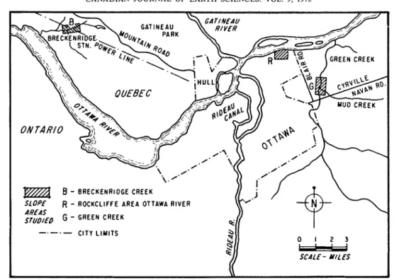
FIG. 1. Map showing general locations of inclinometers.
less fissured, marine clay can be identified by a high ratio of sodium to calcium ions in the pore water. The closely fissured reworked clays have a relatively high concentration of calcium ions. As part of a study of the mechanics of observed landslides, six S.G.1, type inclinom- eters (Kallstenius and Bergau 1961 ) were in- stalled in slopes in the Ottawa area. Three years of slope movement observations from these installations are presented in this paper.
Inclinometer Locations, Installations, and Measurements
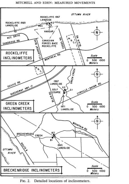
The inclinometer installations were made in slopes at three locations: the south bank of the Ottawa River near Rockcliffe Air Base, the Green Creek Valley near the eastern boundary of Ottawa city limits, and the Breckenridge Creek Valley about 15 mi (24 km) northwest of Ottawa. Figure 1 shows the general locations of'these installations, and Fig. 2 indicates their designation and their location with respect to recent landslides. The six installations are listed in Table 1 together with references to the land- slides shown in Fig. 2. Some basic information on the installations and adjacent landslides is also contained in Table 1.
The inclinometer tubes, 1.5 in. (3.81 cm) I.D. X 1.75 in. (4.34 cm) O.D. semi-rigid P.V.C. (schedule A ) pipe, were pushed into holes hand-augered with a 2 in. ( 5 cm) diam- eter auger bit. The bottom end of each tube was sealed with a conical tip of 2 in. (5 cm) outside diameter. A special pushing apparatus was de- veloped to overcome the friction without bend- ing or crushing the tube. Inclinometer tubes were placed in the lower half of the slope where a rensonably convenient spot to auger a vertical hole could be found. Tube lengths of 10 m were normally used so that the bottom end extended below the elevation at the toe of the slope. Thus it was thought that any deep-seated movement occurring in the slope could be detected.
The initial inclination of each tube was mea- sured at 2 f t (0.6 m) intervals in the pipe several months after installation. Subsequent measure- ments were taken after each seasonal (spring and autumn) peak in ground water levels with occasional intermediate measurements. Move- ments were calculated from the change in incli- nation of each tube using the bottom of the tube as datum. Movements calculated over a 10 m tube length are considered to be accurate to 20.05 cm.
MITCHELL AND EDEN: MEASURED MOVEMENTS
BRECKENRIDGE INCLINOMETERS
I I
FIG. 2. Detailed locations of inclinometers.
Presentation of Measurements
It may be noted from Table 1 that the first three inclinometers listed ( R l , G I , B1) were installed in slopes that were similar to adjacent ones where recent landslides had occurred. Furthermore, these slopes were chosen because they were typical of slopes in their immediate vicinity. The sites of the other three installations (R2, G2, B2), instead of being in typical natural slopes, were chosen because particular environmental factors were prevalent. Measure- ments of slope movements are presented below
for each installation in the order listed in Table 1. In each case a figure showing the slope profile and the inclinometer installation drawn to scale is presented. Measured movements are plotted on the same figure. It should be noted that the scales of these plotted movements are not the same in all figures. It should further be noted that the semi-rigid inclinometer tube is not considered sufficiently flexible to measure the near-surface movements due to solifluction (as recorded, for example, by Williams 1966) and measurements shallower than 1 m are therefore not recorded. All movements were
1004 C A N A D I A N JOURNAL OF EARTH SCIENCES. VOL. 9, 1972 TABLE 1 . Information on inclinometer installations and adjacent landslides
-- - - --
Inclinometer installations Adjacent recent landslides
- --- .- -
Location and General Slope height Slope height Date, type, and
designation slope description and aver. angle and aver. angle size of landslide Reference Rockcliffe R 1 Green creek G I Breckenridge B 1 Rockcliffe R2 Green Creek G2 Breckenridge B2
Natural slope, typical 14 m of this section of the 26" bank
Natural slope, typical 19 m but without toe erosion 28" Natural slope with toe 29 m
loading from spoil of 27" recent landslide
Graded (flattened) natural 13 m
slope 20"
Steep natural slope 15 m
with outcropping marine 35" clay
Natural slope subjected 2 8 . 5 m to unusually rapid erosion 22"
1969 Paul 1970
retrogressive toe failure 8000 yd3
1971
retrogressive toe failure Unp~~blished 8000 yd3
1963 Crawford and
retrogressive toe failure Eden 1967 30 000 yd3.
1967 Eden and
retrogressive toe failure Mitchell 1970 30 000 yd3
1967 Mitchell 1970
2000 yd3 slide in
upper 13 m of slope
1963 Crawford and
retrogressive toe failure Eden 1967 30 000 yd3
downslope as indicated in Figs. 3-8 and are listed in Table 2.
Figure 3 shows the slope profile and position of inclinometer R1. This slope is typical of over a mile of the Ottawa River bank in the Rock- cliffe area of Ottawa and is situated between two recently documented landslides (see Table 1 and Fig. 2 ) . The total slope movements for a period of nearly 2.5 years and the movement during one year are plotted in Fig. 3. Readings taken in May 1969 indicate that most of the annual movement develops during the spring breakup when the ground water levels are high. In this slope the movements average about 0.25 cm per year and the maximum movement is at an elevation corresponding to the toe of the slopc. Although no tension cracks have been observed at the top of this slope, tension cracks have developed in the paved surface of parking areas at the top of similar slopes lo- cated between inclinometer R 1 and the land- slide reported by Paul (1970) and noted in Table 1. These tension cracks are a positive indication of slope movements.
Figure 4 shows the slope profile and the position of the inclinometer G I . This slope is about 200 m downstream from the landslide noted in Fig. 2 and Table 1. A photograph of this landslide is presented in Fig. 9. The major difference between this slope and the slope
where the landslide occurrcd is that Green Creek, in its meanderings, was eroding the toe of thc slopc that failed. In June 1968 Mr. G. Munro, occupant of the land where these slopes are located, showed the authors a tension crack at the location of the backscarp of the landslide shown in Fig. 9 which occurrcd 3 years later. At that time a vertical displacement of several centimeters existed at the tension crack, and an attempt was made to put an inclinometer in this slope rather than the slopc where G I was in- stalled. The slopc that failed was, however, thickly covered by small cedars and it was not possiblc to install the inclinometer in a suitable place.
A large percentage of the total slope move- ment plotted in Fig. 4 developed between Oc- tober 1970 and August 1971. It is unfortunate that no measurements were made immediately following the spring season in 1971, but it is believed that most of this movement occurred during the spring when ground water pressures were high. The water levels in this area were exceptionally high during March 1971 due to the above-normal precipitation. The maximum movement is, again, close to the elevation of the toe of the slope.
The information presented in Fig. 5 refers to a natural slope immediately downstream from the 1963 Breckenridge landslide noted in Table
MITCHELL AND EDEN: MEASURED MOVEMENTS
I I I I I I I I
--
Slope Height = 14m - --
-
Ottawa River Active
-
IceErosionduring-
-
l nclinometer R 1 *Total measured movement
March 1969 to Aug. 1971 0 Measured movement Sept 1970 to ~ u g . 1971 . 8 . 4 0 SLOPE MOVEMENT, cm I I I I I I 0 4 8 12 1 6 2 0 24 2 8 3 2 3 6 HOR I Z O N T A L D l S T A N C E . M E T E R S
FIG. 3. Measured movement in a natural slope, Ottawa River.
TABLE 2. Summary of slope movement measurements
Maximum rate of Average (3 years) Depth of
Inclinometer movement/month Time of max. movement maximum
No. Location (approximate), cm movement cm/year movement Remarks
R1 Rockcliffe 0 . 2 Spring 0 . 2 5 Toe elevation Typical natural
Ottawa R. of slope slope with some
toe erosion
G 1 Green 0 . 3 Spring 0 . 1 1 Toe elevation Natural slope
Creek of slope without toe
Valley erosion
B1 Brecken- 0 . 6 Spring Not Not Shallow inclino-
ridge known known meter toe
Creek stabilization
from former landslide R 2 Rockcliffe 6 . 0 Following 1 . 3 Ground Graded fill on
Ottawa R . slope grading surface natural slope
G2 Green 0 . 2 Spring 0 . 2 7 Ground Movement in
Creek surface fissured clay
Valley overlying stiff
marine clay B 2 Brecken- 4 . 0 Autumn Slope Toe elevation Rapid toe
ridge failed of slope erosion
Creek
1. The tube-pushing apparatus was not avail- May 1969 are larger than the total movements able for this first installation (May 1968) and to August 1971. The explanation of this ap- a maximum depth of 6 m instead of the initially parent anomaly follows.
intended 1 0 m was attained. The movements All measurements prior to August 1971 plotted in Fig. 5 are difficult to interpret, since showed the pattern of maximum movement at the movements between September 1968 and the surface decreasing with depth, as with other
1006 CANADIAN JOURNAL OF EARTH SCIENCES. VOL. 9, 1972 24
I I
I
I -2 0
-
Slope Height = 19meters-
Average Slope Angle = 27.5"
m 1 6 - P: W I Y
-
I n c l i n o m e t e r G I0 Total movements Sept. 1968
-
to August 1971
Movement between October 1970
and August 1971 - - .4 .2 0 SLOPE MOVEMENT, crn 0 1 6 20 24 2 8 3 2 3 6 4 0 4 4 H O R I Z O N T A L D l S T A N C E , M E T E R S
FIG. 4. Measured movement in a natural slope, Green Creek.
I I I I Slope h e i g h t I
-
L
A
Average Slope A n g l e
-
26.5"Spoil f r o m 1963 Landslide
over Valley floor n o
/
active erosion . 2 0 u w
z o
SLOPE MOVEMENT, sm l nclinometer B1 0 Movement S e p t 1968 to May 1%9 Total Movement S e p t 1968 t o August 1971 H O R I Z O N T A L D l S T A N C E , M E T E R SFIG. 5. Measured movement in a natural slope, Breckenridge Creek.
sites. In the spring of 1971, tension cracks ap- changes in inclination of the tube from bottom peared in the slope above the inclinometer to top, it is apparent that the movement in this installation. These cracks indicated that a deep- case is taking place below a depth of 6 m and seated movement had developed and caused the the bottom of the tube is not a fixed datum. reverse tilting of the inclinometer tube. Since The slope in which inclinometer R2 was in- movements are calculated from measured stalled is located directly adjacent to the 1967
MITCHELL AND EDEN: MEASURED MOVEMENTS 1007
I
I
I
I
1 6
Slope Height = 13 meters
Average Slope Angle (graded) =-%
_
v, E Graded Slope 7 I- & , River I - / - -
-I
'?w/
Ground Surface y f " r i o r to Grading 4 ? ~ Inclinometer R22:
Total movementI 8 p
Sept 1%8 to August 1971 -010- 0 Movement after 2 MDnths 6 4 2 0 2 O c t to Dec. 1%8 SLOPE MOVEMENT, crn H O R I Z O N T A L D l STANCE. M E T E R SFIG. 6 . Measured movement in a graded slope, Ottawa River.
Rockcliffe slide noted in Table 1 and in Fig. 2. Concern for the safety of a hangar located at the top of this slope led to a decision to grade the slope, and the inclinometer was installed two months after these grading operations. Figure 6 shows the original slope profile, the graded slope profile, the inclinometer tube, and the measured movements. The movements indi- cate that the overall slope stabilization has been successful, but that the fill material is moving relative to the underlying original material. Movements that developed during the first two months after measurements began represent about one-third of the total movement after three years. Movements between October 1970 and August 1971 were found to be quite small (within the accuracy of the instrument). These data suggest that deep-seated movement can be prevented by increasing the factor of safety of a slope. It also indicates that buried services, installed in graded natural slopes, may be sub- jected to stresses from soil movement.
Figure 7 shows the movements measured in an inclinometer installed in a steep slope com- posed of two clays. T h e lower clay has a high ratio of sodium to calcium ions in the pore water, while the upper clay has a high ratio of calcium to sodium ions in the pore water (San- grey and Paul 1971). The boundary between
these two clays is indicated in Fig. 7 and corre- sponds with the base elevation of a landslide which occurred in the adjacent slope (see Fig. 2 and Table 1 ) . The upper clay is closely fissured (these fissures become apparent when a block of this clay is broken up), while the lower clay appears to be more intact (Mitchell 1970; Sangrey and Paul 197'1). Only the total movements developing over a three-year period are plotted in Fig. 7. Measurements indicate that the upper clay is moving at about 0.25 cm per year maximum but the lower clay shows no movement. All of the other slopes instrumented are composed of clay of similar nature and origin to the upper clay in this slope. Eden and Mitchell ( 1970) have shown that the fissured clays exhibit relatively large strains prior to failure in triaxial tests. The lower marine clay at this location exhibits a brittle type of failure. The data in Fig. 7 support the concept regard- ing the differences in stress-strain behavior of the two clays and indicate that slope movements might occur only in the fresh water redeposited clays.
After the 1963 Breckenridge slide (Fig. 2 ) the creek was dammed with debris and forced to cut a channel at the toe of the opposite slope. Inclinometer B2 was installed in this slope in August 1968 when the creek had eroded an
1008 CANADIAN JOURNAL O F EARTH SCIENCES. VOL. 9, 1972 2 4
1
Slope Height = 17 meters
-
-
Average Slope Angle = 35"
-
-
-
Sangrey and Paul (19701>
/ - - l nclinometer G2 0 Total movement
-
2 1 0 2 Sept. 1968 to August 1971 SLOPE MOVEMENT, crn 0 4 8 1 2 1 6 2 0 2 4 2 8 3 2 3 6 4 0 H O R I Z O N T A L D l S T A N C E , M E T E R SFIG. 7. Measured movement in a steep natural slope with outcropping marine clay, Green Creek.
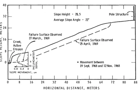
almost vertical face about 4 m high at the base of the slope. By October 10, 1968, this face had undergone considerable suficial sloughing and a tension crack had formed about 3 m downslope from the inclinometer tube. The dis- placements plotted in Fig. 8 were measured on November 12, 1968. At this time a second tension crack had formed about 1 m away from the inclinometer tube. These cracks appeared to extend to about 1 or 2 m depth and were about 2 cm wide at the top. By March 27, 1969, a small landslide extending about 6 m above the inclinometer location had sheared the inclinometer tube and removed the upper half of this installation. By April 25, 1969, a larger landslide about 70 m long by 30 m wide had developed at this site along with another smaller slide on the downstream side. Figures 10 and 11 show the development of these land- slides. The larger slide had a failure plane at about 3.5 m depth almost parallel to the original ground surface and extending to within 20 rn of the pole structure at the top of the slope. Water was seeping out at the backscarp about 0.5 m below ground level on April 25. The profile af this slope and the failure planes
of the landslides discussed above are shown in Fig. 8.
The movement of 0.8 cm measured by the inclinometer occurred during the late autumn months when the ground water levels normally show a small seasonal peak. Larger movements downslope of the inclinometer are indicated by the formation of tension cracks. These move- ments are associated with the removal of toe support by erosion and the maximum move- ment corresponds, in elevation, to the eventual failure surface. It is interesting to note that, despite these large movements, the landslide did not develop until the following spring when the ground water levels were at or near their sea- sonal maximum.
Discussion of Measurements
To investigate the influence of changes in ground water level on deformation in the slopes a sample of clay from the Rockcliffe area (from 10 m depth) was placed in a triaxial cell equipped with a rotating bushing to reduce piston friction. A normal drained compression test was carried out using incremental loads until the sample was at equilibrium under ap-
MITCHELL AND EDEN: MEASURED MOVEMENTS 1009
I
.ISlope Height = 28.5 Pole
structure
-
Average Slope Angle = 22"
-
-
00
Failure Surface Observed 0
- 27 M a r c h . 1969 I Creek, Active I I - Movement between
19 Sept. 1968 and 12 Nov. 1968 0.8 0.4 0 ?
SLOPE MOVEMENT, cm
0 8 1 6 24 3 2 4 0 4 8 5 6 6 4 7 2 80 8 8
H O R I Z O N T A L D l S T A N C E , M E T E R S
FIG. 8. Measured movement in a slope subjected to rapid erosion, Breckenridge Creek.
proximately 90% of its failure load. At this stage the pore water pressure in the sample was increased by 0.05 kg/cm2 by increasing the back pressure from 1.00 kg/cm2 to 1.05 kg/cm2. This would be equivalent to a rise in ground water level of 0.5 m. The small increase in pore water pressure caused the sample, nominally 8 cm high by 10 cm2 in cross-sec- tional area, to undergo an axial deformation of about 0.4 mm in 1 min. After 1 min the back pressure was decreased to 1.00 kg/cm" estab- lishing the earlier equilibrium stresses, and the sample deformation decreased such that no axial deformation was observed during a 2-min period. This procedure was repeated with vary- ing time intervals up to 4 min. After several cycles the sample had undergone about 3.5% axial strain without failure, and equilibrium was again established under the back pressure of 1.0 kg/cm2. This test supports the concept that slope movements are associated with seasonal high ground water levels.
While the data presented cover a period of only three years, there is no indication that these are not continuing conditions. Maximum movements observed in a typical natural slope are in the order of 0.25 cm per year. Maximum movement occurs at an elevation corresponding to the toe of the slope and to the depth of the
most critical failure circle. Maximum rates of movement appear to correlate with periods of high ground water levels. Deep-seated slope movements could theoretically lead to either the formation of tension cracks and subsequent landsliding or, if the slope does not fail, even- tual degradation and stabilization. The latter possibility derives from considerations of con- tinuity; if the toe of a slope movcs outwards and no tension cracks develop, a downward movement of the upper part of the slope and a general decrease in slope angle must occur. Pt might be noted that many of the stable natural slopes in the study areas have a profile charac- teristic of outward toe movement (toe bulging) and decrease in slope angle towards the up- lands. The profile in Fig. 4 could be considered an example of such movements. Field observa- tions suggest that the appearance of tension cracks is indicative of a potentially dangerous slope. Eden and Mitchell (1970) suggested that tension cracks play a direct role in accelerating movements that lead to landslides by providing access for surface water into the shear zone. These authors also showed that there is little post-peak decrease in shearing resistance in laboratory specimens of these clays when tested under the stresses applicable to the landslide problems, a necessary condition if a slope is
1010 CANADIAN J O U R N A L O F EARTH SCIENCES. VOL. 9, 1972
FIG. 9. Landslide in Green Creek Valley, 1971.
to be considered stable following large deep- flattening or by erosion) appear to be deter- seated movements. mining factors in the rate and depth (or form) The effects on slope movements of slope of slope movements. The 1969 Breckenridge flattening, of rapid erosion, and of an outcrop- landslide (that removed inclinometer B2) and ping of underlying stiff marine clay have been subsequent regression resulted in a failure plane investigated. Changes in slope geometry (by that was almost parallel to the original ground
MITCHELL AND EDEN: MEASURED MOVEMENTS 101 1
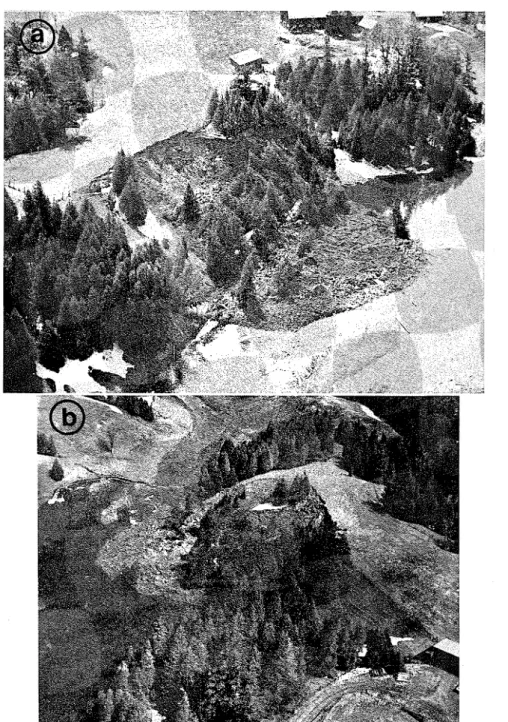
FIG. 10. Breckenridge landslides, March 27, 1969. ( a ) Taken brom helicopter. ( b ) Taker from 1963 landslide crater.
surface. This ifinite-slope type of sliding (as Conclusions
opposed to the usual circular arc slide) is con-
sidered to be related to the form of the slope A summary of the measured slope move- movements resulting from the fairly rapid re- ments is included in Table 2, and the following moval of the toe material. conclusions are drawn from this study:
CANADIAN JOURNAL O F EARTH SCIENCES. VOL. 9, 1972
FIG. 11. Breckenridge slides, April 25, 1969. ( a ) Taken from 1963 landslide crater. ( b )
MITCHELL AND EDEN: MEASURED MOVEMENTS 1013
1. Relatively deep-seated movements do de- periodic measurements is gratefully acknowl- velop in some of the natural slopes in the Ottawa edged.
area. These movements appear to occur during The paper is a contribution from the Division periods of high ground water levels. of Building Research, National Research Coun- 2. Large slope movements and landslides of the cil, Canada, and is published with the approval infinite slope type (failure plane almost parallel of the Director of the Division.
to the ground surface) may occur in the 'fis- sured' clays if toe erosion (or excavation) is extensive.
3. While flattening of natural slopes leads to an increased overall stability, movements are likely to develop at the interface between the fill material and the original ground surface. Care should be taken to insure the integrity of ser- vices placed in natural slopes and, in particular, in flattened natural slopes.
4. Movements measured in inclinometer G2 would tend to support the concept of two clay layers, which exhibit different stress-strain properties, outcropping at this location in the Green Creek Valley.
5. Long-term, deep-seated, slope movements may contribute to apparent degradation of slopes in which landsliding does not develop.
Acknowledgments
Assistance from various members of the technical staff of the Division of Building Re- search, National Research Council, Ottawa, in installing the inclinometers and in carrying out
CRAWFORD, C. B. and EDEN, W. J. 1967. Stability of natural slopes in sensitive clay. J. Soil Mech. Found. Div., A.S.C.E., 93, pp. 419-436.
EDEN, W. J. and MITCHELL, R. J. 1970. The mechanics of landslides in Leda clay. Can. Geotech. J., 7,
pp. 285-296.
GADD, N. R. 1962. Surficial geology of Ottawa map area, Ontario and Quebec. Geol. Surv. Can., Pap. 62-16.
KALLSTENIUS, R. and B E R G ~ U , W. 1961. It1 sitic de- termination of horizontal ground movements. Proceed. 5th Int. Conf. Soil. Mech. Found. Eng. (Paris), 1 , pp. 481-486.
MITCHELL, R. J. 1970. Landslides at Breckenridge, Pineview Golf Club, and Rockcliffe. Tech. Pap. 322, Division Bldg. Res., N.R.C., Ottawa, June 1970.
PAUL, M . J. 1970. Landsliding in sensitive clay soils at Ottawa. M.Sc. Thesis, Queen's University, Kingston, Ontario, 138 p.
SANGREY, D. A. and PAUL, M. J. 1971. A regional study of landsliding near Ottawa. Can. Geotech. J., 8, pp. 315-335.
WILLIAMS, P. J. 1966. Downslope soil movement at a sub-Arctic location with regard to variations with depth. Can. Geotech. J., 3, pp. 191-203.