Congestion-Aware Traffic Routing for Large-Scale Mobile
Agent Systems
by
Sejoon Lim
B.S., Seoul National University (2002)
S.M., Massachusetts Institute of Technology (2008)
Submitted to the Department of Electrical Engineering and Computer
Science
in partial fulfillment of the requirements for the degree of
Doctor of Philosophy in Electrical Engineering and Computer Science
;§
VE
MASSACHUSETTS INSTITTEat
the OFTEHOLOGYMASSACHUSETTS INSTITUTE OF TECHNOLOGY
September 2012
uR
R I E>
h
@Massachusetts
Institute of Technology 2012. All rights reserved.
Author
....
... .. ... ....
. .' . .. . .. . . . .. . . . .Department of Electrical Engineering and Computer Science
June 29, 2012
Certified by
Daniela Rus
Professor
Thesis Supervisor
nAccepted by...
/LesliYAK-kolodziej ski
Chair, Department Committee on Graduate Students
Congestion-Aware Traffic Routing for Large-Scale Mobile Agent
Systems
by
Sejoon Lim
B.S., Seoul National University (2002)
S.M., Massachusetts Institute of Technology (2008)
Submitted to the Department of Electrical Engineering and Computer Science on June 29, 2012, in partial fulfillment of the
requirements for the degree of
Doctor of Philosophy in Electrical Engineering and Computer Science
Abstract
Traffic congestion is a serious world-wide problem. Drivers have little knowledge of histor-ical and real-time traffic congestion for the paths they take and often tend to drive subopti-mal routes. Congestion phenomena are sure to be influenced by the coming of autonomous cars. This thesis presents route planning algorithms and a system for either autonomous or human-driven cars in road networks dealing with travel time uncertainty and congestion.
First, a stochastic route planning algorithm is presented that finds the best path for a group of multiple agents. Our algorithm provides mobile agents with optimized routes to achieve time-critical goals. Optimal selections of agent and visit locations are determined to guarantee the highest probability of task achievement while dealing with uncertainty of travel time. Furthermore, we present an efficient approximation algorithm for stochastic route planning based on pre-computed data for stochastic networks.
Second, we develop a distributed congestion-aware multi-agent path planning algorithm that achieves the social optimum, minimizing aggregate travel time of all the agents in the system. As the number of agents grows, congestion created by agents' path choices should be considered. Using a data-driven congestion model that describes the travel time as a function of the number of agents on a road segment, we develop a practical method for determining the optimal paths for all the agents in the system to achieve the social optimum. Our algorithm uses localized information and computes the paths in a distributed manner. We implement the algorithm in multi-core computers and demonstrate that the algorithm has a good scalability.
Third, a path planning system using traffic sensor data is then implemented. We predict the traffic speed and flow for each location from a large set of sensor data collected from roving taxis and inductive loop detectors. Our system uses a data-driven traffic model that captures important traffic patterns and conditions using the two sources of data. We
evaluate the system using a rich set of GPS traces from 16,000 taxis in Singapore and show that the city-scale congestion can be mitigated by planning drivers' routes, while incorporating the congestion effects generated by their route choices.
Thesis Supervisor: Daniela Rus Title: Professor
Acknowledgments
I have many people and organizations to acknowledge and thank for their support
through-out my doctorate program. I would like to express my deep gratitude to my advisor, Prof. Daniela Rus, for her support and guidance during my time at MIT. I would not have been able to finish my thesis without her guidance and help.
I am also very grateful to my committee, Prof. Hari Balakrishnan and Prof. Sam
Madden, for their suggestions and guidance from the start of my graduate study.
I thank all the collaborators including Prof. Javed Aslam, Prof. Jakob Eriksson, Prof.
David Gifford, Prof. Evdokia Nokilova, Christian Sommer, and Xinghao Pan.
Thanks are also due to all the members of the Distributed Robotics Laboratory, both past and present, for helpful discussions and encouragement.
I am also grateful to all the data providers including CarTel team at MIT, Land
Trans-portation Authority in Singapore, and ComfortDelGro in Singapore.
I would also like to thank the various funding organizations and companies which
have funded my research. These funding sources include the Singapore-MIT Alliance for Research and Technology (The Future of Urban Mobility project), the NSF (grant
num-bers CPS-0931550, 0735953), the ONR (grant numnum-bers 105,
N00014-09-1-103 1), and the Samsung Scholarship.
Finally, above all, I would like to thank my family - my mother, father, brother, and
especially my wife, Grace Lee. They have been infinitely patient with me and have encour-aged me throughout my entire PhD process. I would not have made it this far without their love and support through all these years, and for that I am eternally grateful.
Contents
1 Introduction
1.1 Route Planning on Stochastic Network . . . .
1.2 Stochastic Route Planning using Distance Oracles . . . .
1.3 Multi-Agent Route Planning . . . .
1.4 Data-Driven Traffic Modeling and Estimation . . . .
1.5 Congestion Detection . . . .
1.6 System, Applications, and Experiments . . . .
1.7 Contributions . . . . 1.8 Organization . . . . 19 . . . 21 . . . 24 . . . 26 . . . 28 . . . 29 . . . 30 . . . 31 . . . 32 2 Related Work 2.1 Stochastic Routing . . . .
2.2 Approximate Distance Oracles . . . .
2.3 Multi-Agent Routing . . . .
2.4 Traffic Data . . . .
2.5 Traffic Prediction and Congestion Modeling . . . .
3 Single-Agent Route Planning Under Uncertainty
3.1 Stochastic Network . . . .
3.2 Stochastic Traffic Model based on GPS Traces . . . .
3.3 Efficient Solution for Single Agent Stochastic Shortest Path (SSP) Problem
3.3.1 Problem Formulation . . . .
3.3.2 Stochastic Path Planning by Parametric Optimization . . . .
33 33 35 36 37 38 41 41 42 42 44 47
3.4 Synopsis . . . .
4 Stochastic Route Planning with Precomputation 63
4.1 Background . . . . 64
4.1.1 Stochastic Shortest Paths . . . . 64
4.1.2 Approximate Distance Oracles . . . . 66
4.2 Stochastic shortest-path queries using Distance Oracles . . . . 67
4.2.1 Overview . . . . 67 4.2.2 Preprocessing Algorithm . . . . 68 4.2.3 Query Algorithm . . . . 70 4.3 Practical Considerations . . . . 71 4.3.1 Non-planarities . . . . 71 4.3.2 Directions . . . . 73
4.3.3 Reduced Set of Portals on Separator Paths . . . . 73
4.3.4 Deadline Values . . . . 73 4.4 Experiments . . . . 73 4.4.1 Setup . . . . 74 4.4.2 Preprocessing . . . . 76 4.4.3 Path Queries . . . . 76 4.4.4 Path Examples . . . . 78 4.5 Synopsis . . . . 79
5 Stochastic Multi-Agent Route Planning 81 5.1 Multi-Hop: Stochastic Shortest Path Through a Fixed Node Sequence (SSPFNS) 83 5.1.1 Problem Formulation . . . . 83
5.1.2 Solution Method . . . . 84
5.1.3 Correctness . . . . 85
5.1.4 Complexity Analysis . . . 86
5.2 Multi-Agent and Multi-Resource: Stochastic Shortest Path with General-ized Constraints (SSPGC) . . . . 86
5.2.1 Problem Formulation . . . 86
5.2.2 Solution Method . . . .
5.2.3 Correctness . . . .
5.2.4 Complexity Analysis . . . .
5.3 Extensions: Graph Transformation for Visit Cost and Dependency
5.3.1 Considering Visit Cost . . . 9 4 5.3.2 Considering Stochastic Dependency .
Experiment . . . . Synopsis . . . .
6 Congestion-Aware Multi-Agent Route Planning
6.1 Problem Set-up . . . .
6.1.1 Notation . . . . 6.2 Distributed Algorithm . . . .
6.2.1 Probabilistic Path Choice .
6.2.2 Local Cost Function . . . 6.2.3 Distributed Control Law
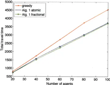
6.2.4 Convergence Analysis 6.2.5 Running Time... 6.3 Asynchronous Implementation 6.4 Evaluation . . . . 6.4.1 Exponential Convergence 6.4.2 Scalability . . . .
6.4.3 Implementation in Grid Net
6.4.4 Path Example in Real Road
6.4.5 Discussion . . . . 6.5 Synopsis . . . . . . . 100 . . . 102 . . . 1 0 2 . . . 1 0 3 . . . 1 0 3 . . . 1 0 5 . . . 1 0 8 . . . 1 0 9 . . . 1 1 0 . . . 1 1 0 . . . 1 1 0 . . . 1 1 1 w ork . . . 113 Network . . . 113 . . . 1 1 3 . . . 1 1 6
7 From Theory to Practice: Traffic Routing System with Sensor Data 7.1 System . . . . 7.2 D ata . . . . 7.2.1 Loop Detectors . . . . 117 . . . 118 . . . 118 . . . 120 88 93 94 94 5.4 5.5
95
96 9799
7.2.2 Probe Vehicles . . . 121
7.3 Rapid Coverage by Probe Vehicles . . . 122
7.4 Synopsis . . . 129
8 From Theory to Practice: Data-Driven Traffic Flow Estimation 131 8.1 Modeling and Predicting Traffic with Taxi Probes . . . 132
8.2 Inferring Traffic Flow Using Taxi Probes Trained by Loop Detector Data . . 133
8.2.1 How Many Taxi Sensors Are Needed? . . . . 135
8.3 Estimating Traffic Flow using Taxi Probes and Inferred Traffic Flow for Limited Locations . . . 140
8.3.1 Quality of Estimation . . . 143
8.4 Synopsis . . . 143
9 From Theory to Practice: Data-Driven Congestion Detection 147 9.1 Background: Fundamental Diagram . . . 148
9.2 Congestion Detection . . . 149
9.2.1 Estimation of the Critical Point in the Fundamental Diagram . . . 150
9.2.2 Classification of Congestion State . . . 151
9.3 Experiments . . . 152
9.3.1 Quality of Flow Estimation . . . 153
9.3.2 Congestion Detection . . . 153
9.3.3 Congestion Detection Quality . . . 154
9.4 Detecting Heavy Traffic . . . 154
9.5 Synopsis . . . 158
10 From Theory to Practice: City-Scale Experiments 161 10.1 City-Scale Applications . . . 161
10.1.1 Volume . . . 162
10.1.2 Hotspots . . . 162
10.1.3 Origins / Destinations . . . 163
10.2.1 Approach . . . .
10.2.2 Link Performance Function Estimation
10.2.3 Algorithm Implementation . . . .
10.2.4 Results . . . .
10.3 Synopsis . . . .
11 Conclusions, Lessons Learned, and Future Work
. . . . 173 . . . 176 . . . 178 . . . 179 . . . 186 187
List of Figures
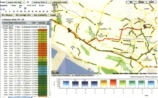
1-1 Web interface for our optimal route query system . . . . 22
1-2 Example application: Taxi booking considering the taxi's location and
un-certainty of travel time. . . . . 23
1-3 Distributed agent-centric approach . . . . 27
2-1 Visualization of Stochastic Shortest Paths . . . . 34
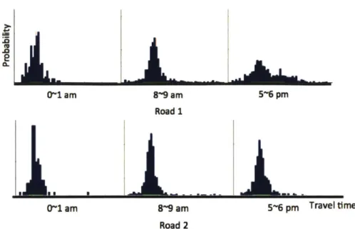
3-1 The travel time distribution of two different road segments for 0 1 am,
8~9 am, and 5~6 pm on weekdays . . . . 43
3-2 Explanation of the Stochastic Shortest Path (SSP) algorithm . . . . 44
3-3 Graphical interpretation of the optimal path in the mean-variance plane . . . 49
3-4 P2 and po was calculated from 5000 random convex hulls with Ne extreme
points. . . . . 57
3-5 Illustration of the latest-departure path for a given probability guarantee . . 62
4-1 Illustration of portals . . . . 66
4-2 The number of k values needed for the road network . . . . 75
4-3 The histogram of the query time for 1,000 random OD-paris . . . . 77
4-4 The histogram of the approximation ratio for 100 random OD-paris . . . . 78
4-5 Path query example for maximizing the probability of reaching the
desti-nation within a user-specified deadline . . . ... . . . . 79
5-1 The delivery truck wants to find the path to maximize the probability of
finishing the work by 5pm. . . . . 83
5-3 The graph shows general constraints. . . . .
5-4 This figure illustrates how we can decompose the constraints of
nodes being visited in any order into A and V. . . . .
Example applications . . . . Illustration of optimal path in mean-variance plane Constraint graph . . . . Graph transformation for visit cost . . . .
Graph transformation for dependency . . . .
Hospital examples in Singapore . . . .
Illustration of social optimum and user equilibrium The condition that social optimum satisfies...
Exponential convergence of our cost function V. Run on 64 Running Time in 64 cores computer . . . . Grid network . . . . Illustration of social optimum solution . . . .
c 87 a group of . . . 88 . . . 89 . . . . 90 . . . . 92 . . . . 95 . . . . 96 . . . 97 . . . 101 . . . 105 ore computer . 111 . . . 111 . . . 112 .. .... 114
6-7 comparison with greedy algorithm and the effect of realization to atomic flow based on the probability result . . . . 6-8 Total travel time vs. different number of paths .. . . . . 7-1 Snapshot of the route planning system's web interface for Singapore . . . . 7-2 Loop data and taxi data . . . . 7-3 Distribution for August 1 and August 2, 2010 over 16 selected road segments 7-4 Voronoi regions of Singapore, extracted through K means clustering on origins and destinations of taxi trips . . . . 7-5 Upper bound on L ' distance between distributions of taxis with different initial distributions . . . . 8-1 8-2 8-3 115 116 119 120 121 125 128 Training and test RMSE for a road . . . 136
Result of regression . . . 137
Coverage according to the number of probes . . . 138
5-5 5-6 5-7 5-8 5-9 5-10 6-1 6-2 6-3 6-4 6-5 6-6
. . . .
8-4 Cumulative histogram of coverage by 30 samples for 300 random
permu-tations for 8am . . . 139
8-5 The dependence of the RMSE for inferred traffic flows on the number of dynamic probes used. . . . 140
8-6 Estimated flow for four different roads . . . 144
8-7 Quality of Flow Estimation . . . 145
9-1 Examples of the fundamental relations . . . 149
9-2 Example fundamental diagram of two different roads . . . 151
9-3 Quality of estimation of relative flow and the estimated fundamental dia-grams for each estimation method . . . 155
9-4 Histogram of correlation coefficient between loop count and loop count estim ation . . . 156
9-5 Quality of congestion detection . . . 156
9-6 Piecewise line fitting to empirical fundamental diagrams, using the MDL criterion to select the number of line segments . . . 157
9-7 Histogram of the gradient of the line segment with the highest car density. . 158 10-1 Snapshots of traffic volume measured by taxi probes for August 2nd 2010 (Monday) plotted on the map of Singapore . . . 163
10-2 Hotspots according to time of day . . . 164
10-3 Number of taxis and trips (in terms of origins and destinations) at different times of days, on both workdays and non-workdays. . . . 165
10-4 Perplexities of empirical distributions of origins and destinations . . . 167
10-5 Probabilities of empirical distributions of origins and destinations . . . 169
10-6 Conditional perplexities of origins given destinations, and vice versa. . . . 172
10-7 Mutual information between origins and destinations . . . 173
10-8 Probabilities of a trip originating and terminating within the same region . . 174
10-9 Statistics of Selected Taxi Trips . . . 175
10-10 Road segments with taxi data . . . 178
10-12 Histogram of TO (left) and Ca (right) . . . .
. . . .
180 10-13 Total cost and average cost per trip for real taxi trips, greedy-optimal pathsand socially optimal paths over time of day . . . 181
10-14 The travel time for real taxi trips, greedy-optimal paths, and socially
opti-mal paths over the number of taxis used. . . . 182
10-15 The savings for travel time for social optimum assignment of sampled taxis 183 10-16 Histogram of trip lengths . . . 184 10-17 Traffic flow between 8 am ~ 8:15 am on August 2, 2010 . . . 185
List of Tables
2.1 Summary of data sources . . . . 38
7.1 Taxi data and inductive loop detector data . . . 119
Chapter 1
Introduction
Traffic congestion is clearly a serious problem: a recent survey estimates that the annual nationwide cost of traffic congestion in the US was $101 billion in 2010, including 4.8 billion hours in lost time and 1.9 billion gallons in wasted fuel. This is an average of
$713 per auto commuter [67]. Drivers today have little knowledge of historical and
real-time traffic congestion for the paths they take, and even when they do (e.g., from "live" traffic updates), there are limited means for using that information to find good paths. As a result, drivers often tend to drive suboptimal routes, and time is used inefficiently when they leave well in advance to make an important deadline. Recent technology developments are so promising that autonomous cars will be prevalent in the near future [125, 91], and congestion phenomena are sure to be influenced by the coming of autonomous cars. Such cars will need a motion planning algorithm to navigate from A to B.
In this thesis, our goal is to solve city-scale congestion problems by understanding the traffic conditions and using them for planning drivers' paths. Our path planning system is intended to find driving directions that lead to fast and reliable travel times for individual drivers and less congestion on a city scale.
Current in-car navigation systems or Web-based route planning systems provide a driver a path from his origin to destination. However, oftentimes the path turns out to be con-gested. Avoiding congestion and finding a good path are not trivial, and the challenge is two-fold: (1) it is hard to predict the travel time for a road segment since many factors such as road conditions, congestion, and events affect the travel time, and (2) congestion is not
fixed but rather is an aggregate effect of drivers' choice of road segments to take for their trips. Thus, a driver's path choice should be optimized considering the other drivers' path choices, and the decision about paths affects other drivers' travel time at the same time.
The challenges addressed in this thesis are: Can we optimize drivers' paths under un-certainty and congestion? Can we reduce city-scale congestion by finding better paths for individual drivers? There are several optimization criteria we consider. From the point of view of the individual we wish to maximize the probability of arriving at the destination and the amount an individual spends in traffic. From the point of view of a group of in-dividuals (where the group can be viewed as city-scale traffic) we wish to minimize the overall time spent by all the users in traffic.
We address these questions using a data-driven approach. We collect GPS data using probe vehicles such as fleets of commercial vehicles, taxis, and individual drivers with GPS-enabled smart phones. When the GPS points are collected with high frequency (i.e. several points each minute) the entire trajectory of individual users can be recovered with great confidence. Traffic delay or speed information can be calculated from sequences of
GPS trajectories.
In addition to GPS data, we also use data from inductive loop detectors. Inductive loop detectors are installed in the road pavement and detect the cars passing over them by detecting the change in electro-magnetic fields. The loop detector data is important because it gives us an accurate (ground truth) measure for all traffic at the locations where the loops are installed. Probe data and inductive loop data are complimentary. Inductive loop data gives us a measure of overall traffic at set points (where they are installed) but does not allow us to track individual drivers as they move through the network. GPS data allows us to track the drivers but presents information only about the GPS-enabled vehicles in the
system instead of the overall traffic network.
The availability of traffic data from loop sensors and GPS probes provides a great op-portunity for developing more intelligent solutions to the transportation problem. However, the following questions need to be addressed in order to understand the scope of the data: How can we turn available traffic data into a useful form? How can we develop a practical algorithm that use these data and find a good path under uncertainty and congestion? In
this thesis, we develop practical algorithms for these questions and their implementation in a city-scale environment.
Our first set of algorithms includes stochastic shortest-path planning to enable a driver to find a fast and reliable path. This algorithms can also be used to coordinate a group of multiple drivers or agents. Our algorithms find a good solution that considers the conges-tion caused by each drivers path choice. Although each drivers contribuconges-tion to congesconges-tion may be small, the aggregate is large. We use real data to model the uncertainty and conges-tion on road segments. More details on our practical algorithms are explained in Secconges-tions
1.1, 1.2, and 1.3.
Our second set of algorithms addresses data analysis, inference, and estimates for traf-fic conditions using static and dynamic sensors. We enable real-time estimation of flow on roads with dynamic sensors calibrated by existing static sensors. Based on the real-time flow and speed information that we obtain from dynamic sensors, we predict the conges-tion levels, and we make it possible to identify the current operaconges-tional state of the roads. These estimates are very valuable information for both individual drivers and city plan-ners. Details for data-driven traffic estimation and congestion detection are explained in Sections 1.4 and 1.5.
Finally, we implement these algorithms using data from a large set of taxi probes and loop detectors and demonstrate that the resulting traffic routing system can be used for guiding human-driven or autonomous cars. Our fast computation techniques and scalable design enable planning for the larger systems in which our algorithms will function. Sec-tion 1.6 provides more detail.
1.1
Route Planning on Stochastic Network
We describe a stochastic motion planning algorithm for multiple agents over a road network with stochastic travel cost, in the presence of visit node constraints. Stochastic travel cost models the uncertainty in travel cost depending on traffic conditions. The travel cost can be time, gas, money, or any combination thereof. Visit node constraints model a sequence of the agents' waypoints required to achieve a specific goal. Waypoints can model the
Frm I Leoile Hill S lb
[1SienceDrv
constraints moide] Map | s rd |M&Noeadline
I Week #An - 15:45-16:45 26 min-0 5 10 15 20 25 30 35 40 45 50 55 3. W
An disance M vtetleOMggrddiiy0(oge1w
L 17n"4"n7.6km
0.29gann5.B~fb
26.1km/h 46sec 30c 30593m 0.002gallon 0.032
16sec 30sec 97.676m 0.004gallon 0.0891b
15c 27sec 85.663m 0.004allon 0.0831bs0 123fl
ISc 28sec 92.516m 0.0O4gallon 0.084lbs2 5 1 d n Val" 6sc 19sec 38.203m 0.O2gadon a.035bs21.5.Kkh
21sec 57"ec 141 181m 0.006gllon 0.1191 2*" K.. ft _ 4h__ _ _M 17ec 43sec 4 88.866m 0,005gailon 0.0921 aCe 10a90
30sec 58sec 157.273m 0.008gallon 0.1691b H_ 7sec 10sec 27.055M 0.002gallon 0.0391h 1_
12ec 17sec 54.53m 0.0O3gallon 0.068 1b
8sec 5sec 35.804m 0.002ganon 0.0448 bu
4sec 6sec 20.m 0.001gaion 0.022
11sec 20sec 60.821m 0.003galton G.059 bs 20.7%k" z 2N
3sec 6se 19.029m 0.0019ation 0.0151bs26*6kmh
h
14sec 33sec 128.016m 0.004"lton 0.079thbm
8sec 20sec 78.063m 0.0029ailon 0,0441 4 4sec 10sec 6 .599m 0.001gallon 0.024b1
7sec 17sec 115.027m 0.002gallon 0.04lbs 1
9se 21 c 1,917m 00
galon
0.0081 1,0#5s 1sec 178.1r1m 0.004gation 0.0t1e pn includin Hssseiafa l deay f dravel,
and a dedlne if.15 004alln. Th re
~and#
greeMK-n ldfti e nfthe mapka showV tw different o pwta 8sec 25sec 11o1.184m 0.002gaslon 0.0471 sfor
3t
an3sec 10sec 41.733m 0.001gallon 0.0181b
isec 3sec 11.118m o.gallon 0.0051s
14sec 46sec 132.884m 0.004gallon 0.0791b 2 13sec 42sec 120.523m 0,004gallon 0.0711b 1I
6se 20sec 57.809m 0.002galnon 0.0341b I C 2
1sec 4sec 11.973r- 0.Ogallon 0.0061 t
43sec 108sec 503.93m 0.012gallon 0,2391 1
Figure 1-1: Web interface for our Web-based optimal route query system. The interface gets user input through the top-left panel including address, time of travel, day of travel, and a deadline, if any. The red and green lines on the map show two different optimal paths using our system's statistics for the travel time estimates. The left panel shows the information of each segment in the routes, and the bottom panel shows the travel time estimates of early and late departure by multiples of 30 minutes from the user's intended departure time.
locations of resources to pick up or the location of one or multiple destinations.
Suppose a person calls a taxi company for help to get to any nearby hospital within ten minutes. How can the probability of getting there on time be maximized? It is important that a specific taxi, a specific hospital, and a specific path from the taxi's original location to you and from you to the hospital should be selected in order to maximize the probability. Similarly, if there is a fire in a building, how do we maximize the probability that at least one of the fire trucks can get water from one of several fire hydrants and get to the burning building within five minutes? A specific fire truck, a specific fire hydrant, and a specific path that connects the truck, the hydrant, and the building should be selected in order to maximize the probability.
in-Al.J
Figure 1-2: Example application: Taxi booking considering the taxi's location and uncer-tainty of travel time. The person want to go to one of the hospitals in ten minutes. There are multiple available taxis at different locations. Which taxi should be dispatched and which route should be used to get him to the hospital on time with the highest probability?
creasing. Today, with the technical achievements of advanced driver assistance systems, location-aware mobile networks, and acquisition of traffic information, it is more possi-ble than ever before to calculate and provide the optimal path for either human-driven or autonomous vehicles.
We formulate a general framework for the stochastic shortest-path problem with visit node constraints to capture a large range of stochastic shortest-path problems in the pres-ence of multiple agents, multiple resources, and multiple destinations.
The first challenge in solving the stochastic shortest-path problem with visit node con-straints is that the optimal substructure does not hold [83]. In many other problems, the optimal substructure is used to develop efficient algorithms. In the hospital example, if the travel time of each road segment were a fixed deterministic value, the fastest vehicle to the patient would be guaranteed to be the fastest vehicle arriving at the hospital. In addition, the fastest path from the taxi's original location to the patient's location would consist of the fastest path from the taxi's original location to the hospital via the patient's location. However, this property does not hold for goals such as maximizing the arrival
probabil-ity in a road network whose road segments are associated with a travel time distribution rather than a fixed value. The second challenge is that the number of possible routes grows exponentially with the number of waypoints describing the constraints.
We formulate different classes of stochastic shortest path problems depending on the structure of visit nodes constraints. First, we define and solve the Stochastic Shortest Path with Fixed Node Sequence (SSPFNS) problem, where an ordered list of nodes to be vis-ited is specified. We provide an efficient method that deals with the first challenge. Many multiple-hop stochastic routing applications are formulated by SSPFNS. Second, we de-fine and solve the Stochastic Shortest Path with General Constraints (SSPGC) problem, where constraints describe complicated combinations of node visit sequences. The SSPGC problem covers more general problems, including multiple-agent, multiple-resource, and multi-destination routing applications.
This research is motivated by motion planning in a road network, but the algorithm is general so that it can be applied to broader areas of robot motion planning in uncertain environments. For example, we envision that the algorithm can be extended to find a tra-jectory for a robot arm to move in a space maximizing the probability of achieving the goal
within a given cost.
1.2
Stochastic Route Planning using Distance Oracles
This thesis presents and evaluates a new practical algorithm for planning the motion of vehicles (autonomous or human-driven) on roadways in the presence of uncertainty in traf-fic delays [86]. We build on prior work on stochastic motion planning [83, 101, 102], which introduces stochastic motion planning and route planning algorithms. This prior work presents novel provably correct algorithms that are very well suited for planning the motion of a vehicle on small-scale graphs; however, the computational complexity of this prior suite of stochastic motion planning algorithms makes these algorithms impractical to use for real-time motion planning on city-scale road networks.
The stochastic motion planning model incorporates traffic history in the form of prob-ability distributions of delays observed on actual road segments. The probprob-ability
distribu-tions capture the historical delay observadistribu-tions that are assigned as weights on the edges of the road network. The stochastic motion planning algorithm minimizes a user-specified cost function of the delay distribution. Current route planning methods can produce routes with shortest expected time (based on historical traffic data) and some recent commercial systems, using almost-real-time data based on cell-phone locations [126, 116], can also compute "smartest" routes in dynamic traffic scenarios. The algorithm in this thesis im-proves significantly on this previous work by enabling fast routes guaranteed to maximize the likelihood of arriving at a destination within a specified deadline in city-scale route graphs, in the presence of limited data storage. This work provides a planning system that can be used by autonomous as well as human-driven vehicles for traffic routing applica-tions that meet travel goals such as "when should you leave, and what path should you take, to reach the destination by the given deadline with high probability?" Preserving the inherently non-deterministic nature of actual traffic, we work with accurate probabilistic models of traffic-intense areas; in our work, we actually build a probabilistic model of an entire city's road network based on a large set of heterogenous GPS traces.
More specifically, the algorithm in this thesis improves the state of the art on stochastic motion planning [101, 102] and its application to traffic routing [83]. The running time of the state-of-the-art stochastic-shortest-path algorithm is approximately quadratic in the number of nodes, rendering it too slow for real-time performance on city-scale networks. We improve upon their running time by using efficient data structures. The preprocessing algorithm runs in almost linear time and it does not depend on the origin and destination pair. The query algorithm runs in sublinear time (whereas the algorithms in [83] run in polynomial time). The running time of the query algorithm is almost logarithmic, offer-ing exponential speedups over previous algorithms and allowoffer-ing for almost instantaneous response times.
We implement the algorithms described in this thesis and packaged them as a route planning system. We evaluate the system using the road map of an entire city. Using
GPS traces from a very large fleet of taxis (16,000 vehicles), we are able to extract a
time-dependent, probabilistic model for each individual road segment. Our algorithms preprocess the road network equipped with probabilistic edge lengths into a data structure.
Using this data structure, our query algorithm can efficiently answer approximate stochas-tic shortest-path queries. Our experiments validate the theorestochas-tical performance predictions, showing improvements upon existing query algorithms by several orders of magnitude.
In summary, we propose an algorithm that improves upon the state of the art in stochas-tic motion planning, providing a method that can answer stochasstochas-tic shortest-path queries in almost logarithmic time using a data structure that occupies space roughly proportional to the size of the network. Our method has proven worst-case guarantees and it is applicable to real-world scenarios. Applied to traffic navigation, we obtain a method that can efficiently find a path with almost maximum arrival probability given a user-specified deadline.
1.3
Multi-Agent Route Planning
Several of our recent traffic planning algorithms consider optimizing a driver's path in the
presence of congestion [82, 83, 85]. However, as the number of drivers who use the
sys-tem increases, the paths computed by an agent-centric syssys-tem have degraded performance. Instead of optimizing individual travel times, we focus on optimizing the collective per-formance of a multi-agent transportation system by aiming to achieve the social optimum. The social optimum is defined as the minimum aggregated travel time for all the agents in the system. The social optimum approach is different from computing the user equilib-rium to achieve the optimal path for each individual driver [127, 114]. In a social optimum planning system, some agents may be guided along expensive sub-optimal paths in order to achieve the overall best system performance.
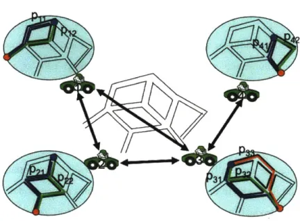
In this thesis we describe a new distributed algorithm for planning paths for multiple agents in a road network. The goal is to minimize congestion and achieve the social op-timum for traffic flow in the system. The social opop-timum minimizes the sum of the total cost for all the agents in the system. We wish to provide each agent with a decision system for selecting its path from origin to destination by making local decisions that depend only on the other agents whose paths might overlap in segments with this agent's path. This "localized" reasoning will ensure scalability and real-time performance.
Figure 1-3: Distributed agent-centric approach. The neighbors of an agent are any agents whose potential paths overlap with those of the agent in any road segments. The potential
paths for each agent is drawn in a blue circle. A pair of neighboring agents are indicated by
a bi-directional arrow. Each agent maintains the probabilistic path decision vector, and up-dates it based on the neighbors' path decision vectors. The communication of path decision vectors is required only between neighbors.
are either driven by people or autonomous. Mitigating congestion in road networks is one of the most important challenges of urban transportation and multi-agent management of navigation. Our algorithm also benefits swarm robotics applications where many robots move in parallel. Mitigating collisions is a costly operation (with respect to perception, computation, and communication) and if the robots can organize their paths from their origins to their destinations to "spread" and minimize the number of likely intersection points, the overall system performance increases. Other applications include planning for evacuation and disaster response.
In our previous work [82, 83], we considered stochastic motion planning for a single agent from a given origin to a destination in a stochastic graph whose weights were prob-ability distributions corresponding to historical congestion. In this thesis we extend this work to motion planning for multiple agents in stochastic graphs with a guaranteed social optimum for the solution.
1.4 Data-Driven Traffic Modeling and Estimation
Understanding traffic conditions and patterns, such as origins and destinations or trips, car routes, and traffic volume and congestion, is critical for finding a path for a driver and for urban traffic planning. Traffic information is collected today through manually conducted surveys (for origins, destinations, routes), or using static sensors such as traffic cameras and loop detectors' (for volume, congestion). However, survey data are often incomplete, inaccurate, and out of date, and static sensor data are incomplete and often difficult to analyze and aggregate, especially in real time. It is also typically sparse, relative to the size of the entire road network. In this thesis, we consider a third source of data: a vehicular sensor network that consists of a roving fleet of dynamic sensor "probes." Commercial vehicles are often outfitted with GPS devices that log their locations and speeds at regular intervals; increasingly, so are federal, state, and municipal vehicles. These vehicles form a mobile sensor network, providing real-time information on the state of the road network.
In a large-scale study conducted in the country of Singapore, we collected the travel data (including GPS, speed, and car state) from a fleet of 16,000 taxis for the month of August 2010, representing approximately 500 million individual data points. The taxis transmit the data using a cellular network. Thus, their data can be used in a real-time mode or in a historical mode.
We develop a method to estimate traffic volume for a road segment using taxi data and inductive loop detector data. Our model and inference procedures can be used to analyze traffic patterns and conditions from historical data, as well as to infer current patterns and conditions from data collected in real time. As such, our techniques provide a powerful new data source for traffic visualization, analysis, and urban planning.
We provide intuition as to why a vehicular network consisting of taxis is well suited to the problem of describing traffic patterns: we demonstrate empirically and theoretically that taxis, no matter what their initial locations are, tend to rapidly "spread out", thus providing good and consistent "coverage" of the road network, by showing that they behave like
rapidly mixing Markov chains.
1
Loop detectors are inductive loops installed in the road network, typically at intersections. They can detect metal and thus and count vehicles.
This work builds on prior studies on traffic to estimate traffic volume and speed [38] and mobility to measure the origins, destinations, and trajectories of trips [87].
1.5
Congestion Detection
Multi-agent congestion-aware algorithms require a congestion model that captures the re-lationship between flow and travel time. Learning this rere-lationship is challenging. In this thesis we provide a method for learning the flow-travel time relationship, develop a congestion-aware routing system that uses it, and evaluate the multi-agent socially optimal path planning algorithm against real data. Specifically, we develop the congestion model using one month of data from 16,000 taxis and 10,000 loop detectors in Singapore.
In this thesis, we propose using loop detectors together with a new source of data-a roving fleet of dyndata-amic sensor "probes"-to estimdata-ate in redata-al time (1) the funddata-amentdata-al diagrams of road segments, which define their effective capacities, (2) the critical points in these fundamental diagrams, which effectively define the onset of congestion, and (3) the current operating level of the road. The critical congestion point of a road segment is defined as the road traffic state where the road capacity is reached and congestion starts. The ability to estimate critical congestion points off-line, as well as the ability to determine the current operating condition of a road segment relative to these critical points in real time, has the potential to make an enormous impact on urban planning. Knowing when a road state approaches congestion can be used by urban planners and road network users to make many decisions such as suggesting or taking alternative routes, setting congestion pricing schemes, and selecting public transportation routes and schedules.
Detecting congestion in real time is difficult, given standard techniques and data sources. However, GPS technology enables the estimation of the speed and position of vehicles. We propose a congestion estimation methodology based on estimating the fundamental rela-tionship between traffic flow, density, and speed for any road segment off-line and then determining a road segment's state using this learned relationship and dynamic sensor data on-line. We demonstrate how all this information can be gleaned from taxi probes equipped with GPS sensors and existing loop detector data. Using the extensive data described in
Section 1.4, we develop a method for estimating the critical congestion point of a given road segment by (1) estimating the fundamental diagram for that road segment off-line and (2) estimating where in the fundamental diagram the current road state lies on-line.
In this thesis, we provide an efficient method for estimating road flow information for any road segment using the taxi sensor network and existing loop detectors. Since not all roads have loop detectors, we show that if we can estimate flow well, we can also accurately estimate the critical congestion point for the road. We propose a method that estimates the flow of a location without loop detectors using the real-time loop count information from "similar" locations and the real-time taxi count for the given location. We use the dynamic taxi sensor network, calibrated with static loops, to statistically infer fundamental diagrams and critical congestion points and dynamically evaluate road performance in relation to these critical points. We evaluate the accuracy of our method using the Singapore taxi and loop detector data.
We also discuss how the theoretical fundamental diagrams are an idealized model of the relationship between flow, density and speed. Specifically, the theoretical fundamental diagrams postulate two distinct operational states of 'free flow' and 'congestion.' In real-ity, we find that additional operational states, such as 'heavy traffic', may exist between the 'free flow' and 'congestion' states. Furthermore, the state of 'true congestion', where it is impossible to increase throughput, may never be empirically observed on a road. We show how the multiple operational states may be discovered from empirical data and dis-tinguished from the 'true congestion' state.
1.6
System, Applications, and Experiments
Using the flow-delay function for each road segment, we build the congestion-aware route planning system with street-level congestion models. First, we estimate the flow of each road segment using the loop detector data and the taxi data. Next, we estimate the flow-delay function. We then implement the single-user congestion-aware algorithm [83] and the multi-agent path planning algorithm [84] to capture the dual types of optimization we wish to support in such a system: (1) the multi-agent social optimum and (2) greedy
opti-mal planning. Using the system and taxi travel paths we show that the multi-agent social optimum algorithm improves the system performance by 15%.
1.7
Contributions
The main contributions of this thesis are as follows:
1. Efficient exact stochastic motion planning algorithms-A stochastic motion planning
problem is presented which is general enough to represent many scenarios involving multiple agents, multiple resources, and multiple destinations. An efficient algorithm is developed to find an optimal agent, resource, locations to visit, and path coping with the travel time uncertainty.
2. Approximation Algorithm for Stochastic Motion Planning by Pre-computation-A
speed-up method for stochastic shortest-path queries is developed with guaranteed approximation bound in optimality. The method is efficient both in query time and storage space.
3. Congestion-aware Multi-agent Routing Algorithm-We develop a multi-agent route
planning algorithm and prove the convergence and rate of convergence. The algo-rithm is decentralized, using only local information; thus, it scales well for large network problems.
4. Flow Estimation and Congestion Detection-Data-driven methods of flow estimation and congestion detection are proposed and validated using real data from GPS sen-sors and inductive loop detectors.
5. Implementation of Routing System-Our traffic routing system uses the flow-delay
function to estimate street-level congestion models and implements multi-agent congestion-aware routing with the social optimum guarantee.
6. City-Scale Experiment-We run experiments that show comparison between actual
1.8
Organization
This thesis is organized as follows: Chapter 2 summarizes related work. Chapters 3, 4,
5, and 6 present the traffic routing algorithms and their theoretical analyses. More
specif-ically, Chapter 3 provides a single-origin single-destination stochastic route planning al-gorithm. Chapter 4 shows how we can speed up the stochastic shortest-path calculation using pre-computation. Chapter 5 presents stochastic routing in the presence of multiple agents and multiple visit locations. Chapter 6 gives a multi-agent routing algorithm con-sidering the changing travel times in road segments depending on the agents' path choices. Chapters 7, 8, 9, and 10 provide the implementation of the theories and algorithms and experimental results. Chapter 7 describes our traffic routing system implementing the de-veloped algorithms and the data used for the system. Chapters 8 and 9 present data-driven model estimation methods. Chapter 8 presents a method for traffic flow estimation using sensor data. In Chapter 9 we describe how we detect traffic congestion. Chapter 10 presents the experimental results of our traffic routing system using real data, estimated congestion models, and our algorithms. Chapter 11 summarizes this thesis, provides lessons learned, and outlines possible future research.
Chapter 2
Related Work
Our proposed algorithms and systems are further related to prior work in the fields of stochastic shortest paths, distance oracles for planar graphs, multi-agent routing, traffic prediction and congestion estimation. In this chapter, we summarize related works.
2.1
Stochastic Routing
Our work is closely related to stochastic planning and stochastic shortest-path algorithms. Prior work has considered stochastic shortest paths under the assumption that the travel time follows a known probability distribution [118, 21, 88, 129, 96, 101, 102]. In stochas-tic shortest path, edge costs are probability distributions rather than determinisstochas-tic costs and the optimal path depends on drivers' diverse objectives. When a driver's objective is to minimize the expected travel time, the problem becomes the deterministic shortest-path problem. It is well known that Dijkstra's algorithm is optimal and applicable for determin-istic problems. However, for some goals such as maximizing the probability of arriving within a given deadline, the optimal path cannot be found with the standard shortest-path algorithms since the optimal substructure property does not hold.
Stochastic shortest-path problems are characterized by stochastic instead of
determin-istic edge weights [21, 88, 96, 118, 129, 101, 102, 100, 83]. Because the edge weight
is represented as a probability distribution rather than a fixed value, there can be many different optimal path definitions. A few frequently used optimality criteria are [83]:
V.= V
0P attlh E
dM d, d2 d3 d4
Figure 2-1: Visualization of Stochastic Shortest Paths. Stochastic shortest paths optimize drivers' goals considering the probability distribution of delays for road segments. Left: The goal is finding a path that maximizes the probability of reaching the destination within a given deadline d (Probability-Tail Model). Right: The goal is finding a path that allows the latest departure, guaranteeing that the probability of making the deadline is at least a given probability value (Mean-Risk Model). X axis and Y axis of the plots represent the mean and variance of the travel time statistics for a path. Reprinted from [83].
" Given an origin and a destination, find a path that maximizes the probability of
reach-ing the destination within a given deadline. (Probability-Tail Model)
" Given an origin and a destination, find a path that allows the latest departure
guaran-teeing that the probability of making the deadline is at least a given probability value. (Mean-Risk Model)
There have been many studies on single-origin single-destination stochastic shortest-path problems. Nikolova et al. [102] developed an algorithm and theoretical bounds by assuming that delays are both Gaussian and independent on different road segments. Inspired by this algorithm, we developed a method that improves performance by removing unnecessary in-vocations of shortest-path searches [83]. In this thesis, we focus on stochastic shortest-path problems with multiple origins, multiple destinations, and multiple intermediate visit node constraints. This thesis builds on the single-origin single-destination stochastic shortest-path algorithm developed in [83]. We show how to utilize the parametric optimization block in [83] to solve the constrained stochastic shortest-path problem. Related prior re-search considers the visit node constraint problems in deterministic graphs [33, 47, 68].
33] in a deterministic setting. Significant research has been done on the stochastic
shortest-path problem [109, 95, 28, 45, 107, 118, 97, 82, 83, 88, 96, 101, 102]. [23] developed a
smartphone based routing system that maximizes the probability of reaching the destination within a given time budget. However, most of the stochastic shortest-path research has focused on the single-origin single-destination case without any constraints. We extend the prior work by providing a solution to the stochastic shortest-path problem for multiple agents with visit node constraints on a stochastic network.
2.2
Approximate Distance Oracles
An (approximate) distance oracle is a data structure that efficiently answers shortest-path and/or distance queries in graphs. Relevant quantities of a distance oracle include the
preprocessing time, which is the time required to construct the data structure, the space
consumption, the query time, and, for approximate distance oracles, the stretch, which is the worst-case ratio among all pairs of query nodes of the query result divided by the actual shortest-path distance. Approximate distance oracles using quasilinear space for
poly-logarithmic query time and stretch (1
+
e) are known for planar [123](implementa-tion in [94]), bounded-genus [70], minor-free [11], geometric [57], and bounded-doubling-dimension graphs [16]. For realistic traffic scenarios, we need the distance oracle to work with directed graphs (also called digraphs). For planar digraphs, Thorup [123] gave an ap-proximate distance oracle that occupies space O(ne7' log(nL) log(n)) and answers (1
+e)-approximate distance queries in time O(e-1 + log log(nL)), where L denotes the largest
integer length of edge weights (see [70] for different tradeoffs between space and query time).
Furthermore, many efficient practical methods have been devised [52, 115, 17], their time and space complexities are however difficult to analyze. Competitive worst-case bounds have been achieved under the assumption that actual road networks have small
2.3
Multi-Agent Routing
There have been many studies in finding the social optimum and the user equilibrium in traffic [77, 114, 31, 69]. Incremental planning for multiple drivers was studied in [131] using the assumption that the stochastic travel time for a road segment changes according to the number of previously planned drivers. Our work is closely related to traffic control problems of multiple agent systems, multicommodity-flow problems, and congestion game problems [44, 80, 128, 78, 32, 117]. The multi-commodity flow problem is a network flow problem with multiple commodities (or goods) flowing through the network, with different source and sink nodes. There have been many studies on congestion control in communication networks [72, 71, 89, 12]. In game theory, many studies have been done to find user equilibrium [127, 49, 50, 19]. There are studies in fractional flow settings [40, 14,
105]. In this thesis, we treat the probability of agent's path choice as fractional flow. Our
research finds the path choice probability of each agent to achieve the social optimum. The algorithm for finding the probability is deterministic, but the actual assignment of agents to a path is stochastic according to the probability. Our probability of path can be viewed as similar to the mixed strategy in game theory. In [110], the convergence result was given for the previous algorithm called the method of successive averages. The research provides the convergence result, but the rate of convergence is not given. Our work provides the convergence speed. In addition, [110] requires the global information. Our work only requires local information, so the algorithm can run in a parallelized way.
In [36], stochastic user equilibrium (SUE) was introduced. The probability of route choice is modeled as a logit distribution according to the measure travel times of K paths for each driver. We also use this concept and find the optimal probability of route choice. The law of large numbers is the basis for the construction of link flows. The link flow is the summation of all the path probability for all the paths that have the link in the path. The stochasticity explains the route choice probability of individuals due to the perception errors. The stochasticity is about the random choice based on perception error and is not about the stochastic travel time. In this work and following many studies, the probability of path choice is considered as fractional flow for the path. [75] developed an algorithm for
finding stochastic user equilibrium solution for congested transit networks.
[119] compares the implementation of different traffic assignment methods.
2.4
Traffic Data
The state of the art in estimating traffic uses static sensors such as loop detectors or traffic cameras [6]. The static sensors are installed at fixed points and provide traffic estimates at that single location. They require significant effort to deploy and maintain, and they fail to capture traffic flow and trajectory information. Some recent studies have began to investigate the use of GPS devices as dynamic traffic probes for inferring traffic volume using existing mathematical models [55, 62], or they estimate traffic speed from GPS [134,
133] or from special-purpose static sensors [3, 4].
Measuring mobility patterns is more challenging than measuring traffic volume. The state-of-the-art methodology for recording the origins and destinations (OD) of trips is a manually-conducted survey [39, 113, 7, 8]. OD surveys include household, workplace, or roadside surveys and aim to identify where people start and end their trips. There are many shortcomings with this method. The surveys measure the average rather than actual travel behavior, they cover only a small subset of trips, and given the manual nature of the method, the information (e.g. travel time) is poorly estimated by the interviewee. More recently, estimating origin and destination has also been done using the observed link flow information [27, 58, 22, 13, 61, 59, 60]. However, the results of this method depend on an underlying model of traffic and the number of link flow measurement locations. Surveys have also been used to estimate route choices, although the results are not reliable due to the complexity and scale of the route selection problem in a dense network of roads. Truck fleets have been used to identify truck routes using loop detector counts [112]. Table 2.1 summarizes these previous studies according to the data sources used and the information extracted from them.
Table 2.1: Summary of data sources
oSurvey Static sensors Dynamic sensors
Origin and Household survey, OD estimation
tech-destination workplace survey, nique with observed
Roadside interview link flows [27, 58, 22,
[39, 113, 7, 8] 13, 61, 59, 60]
Route Reconstruct truck
routes from loop
detector counts [112]
Flow Loop detectors and Estimate flow from
cameras, etc. [6] GPS data [62]
Speed Advanced loop detec- From GPS[134, 133]
tors and cameras, etc.
2.5
Traffic Prediction and Congestion Modeling
Many traffic routing systems have been developed based on travel time estimation from
GPS data collected by probe vehicles [65, 138, 37, 48, 82, 63].
[65] developed a sensor network system that collects cars' traces while they are moving
and transmits the GPS information through open Wi-Fi access points. For probe vehicles to be the basis of a real-time traffic monitoring system, it is necessary that the travel-time measurements made by them be reliable, adequate and timely. In [66], coverage of roads for a traffic congestion monitoring application is provided based on simulations. [138] proposed a method of identifying traffic conditions and patterns on surface streets given location traces collected from on-road vehicles and infrequent low-bandwidth cellular up-dates. [37, 48] estimated the number of probe vehicles required for various types of road networks using simulation. [135] uses machine learning techniques to predict the travel time.
Prior research for estimating traffic flow includes [34, 122, 121]. [73] uses simulation tools to address macroscopic simulation of a real large-scale motorway network. [42] uses statistical learning theory to predict flow. [64] predicts traffic flow and congestion for a small set of known bottleneck regions by using a large set of historical and realtime data to construct a Bayesian network. However, the algorithm in [64] cannot predict the traffic on
every roadway and street in a city, nor can it predict the fastest route between two arbitrary points in a city. [111] uses neural network methods to estimate traffic flow.
The fundamental diagram of a road describes the relationship between flow, density,
Chapter 3
Single-Agent Route Planning Under
Uncertainty
This chapter presents a single-origin single-destination stochastic shortest path algorithm. The algorithms in Chapter 4 and Chapter 5 build on the algorithm described in this chapter.
Section 3.1 provides the set-up for the stochastic network, and Section 3.2 describes the
stochastic traffic model using GPS traces. Section 3.3 summarizes the stochastic shortest-path algorithm in [83].
3.1
Stochastic Network
We model the road network as a directed graph G = (VE) consisting of a set of vertices
V that represent road intersections, and edges E C V x V that represent road segments
between intersections. Associated with each edge e is the travel cost distribution we ~ ,/r (me, ve), which is assumed to be a normal distribution with mean me and variance Ve of the travel cost of e. We assume that this distribution is independent from travel cost distributions at other road segments.1
'Stochastic dependency between adjacent edges can be considered by transforming the given graph as

![Figure 4-3: The histogram of the query time for 1,000 random OD-paris. 'Pruning al- al-gorithm' refers to Algorithm 1 in [83]](https://thumb-eu.123doks.com/thumbv2/123doknet/14454343.519322/77.918.201.724.128.649/figure-histogram-query-random-pruning-gorithm-refers-algorithm.webp)