Access to the River: Rethinking the Role of Storrow Drive
An Opportunity For Transportation Planning
With Urban Objectives
by Peter A. Duerr
Bachelor of Arts, Economics (1989) University of California, Irvine
Submitted to the Department of Urban Studies and Planning in partial fulfillment of the requirements for the degree of
MASTER OF SCIENCE in Transportation MASSACHUSETTS at the INSTITUTE OF TECHNOLOGY May 1992
@ Massachusetts Institute of Technology 1992. All rights reserved.
Author
N
Department of Urban Studies and Planning May 8, 1992
Certified By
Frederick Salvucci Senior Lep&pr at the partment of Civil Engineering Thesis Supervisor
Accepted By
Ce CRalph Gakenheimer
Chairman, Iprtental Committee on Graduate Students
MASSACHUSETTS INSTITUTE
MIT Libraries
Document Services
Room 14-0551 77 Massachusetts Avenue Cambridge, MA 02139 Ph: 617.253.2800 Email: docs@mit.edu http://libraries.mit.edu/docsDISCLAIMER OF QUALITY
Due to the condition of the original material, there are unavoidable
flaws in this reproduction. We have made every effort possible to
provide you with the best copy available. If you are dissatisfied with
this product and find it unusable, please contact Document Services as
soon as possible.
Thank you.
The Library and Archival copies of this theis
(
Duerr, Peter; 1992 ) contains B&W reproductions
only. A more detailed grayscale version is not
available.
Access to the River: Rethinking the Role of Storrow Drive 1
Abstract
Highway construction and expansion in the postwar years have created dramatic and damaging incisions into the urban park system. The consumption of valuable land by massive interchanges and curtailment of pedestrian mobility in and around these areas have had an especially severe impact along the Charles River Esplanade and its linkage points with the rest of the park system.
At a time where the final projects from the Boston Transportation Planning Review era are nearing completion, large increases in automobile travel are projected which will overload an already congested road network. As a response to these expected developments and the need to find alternative solutions to assure both mobility and Boston's urban vitality in the future, a new approach to transportation planning is proposed. Rather than simply continuing to accommodate growth in vehicular travel and mitigating its environmental consequences, an urban/environmental objective is formulated first and transportation policies devised such as to best manage transportation resources under the stated objective.
The application of this concept to Storrow Drive shows that accessibility from the abutting neighborhoods to the Esplanade and open space linkages could be substantially improved. While supporting policies could complement the endeavor to enhance the quality of the urban environment, the improvement of the urban environment would at the same time promote the application of these policies in order to achieve similar objectives elsewhere.
Environmental objectives will not only be aided by a policy approach which emphasizes the role of pedestrians and open space in cities but actually provide the impetus for an implementation of such measures. Therefore, rethinking the role of Storrow Drive could help to change the direction of urban transportation planning if it is understood as an exemplary effort by the community to reclaim urban spaces.
Access to the River: Rethinking the Role of Storrow Drive 2
Preface
This project has been motivated to a large degree by a class taught by Dennis Frenchman, "Cities of Tomorrow." To think about how to plan tomorrow's cities we needed to understand what we liked and disliked about today's. It struck me that people seemed to dream of having the best of two world's by moving into more rural settings in the suburbs while maintaining a life line to the city. As the motor vehicle allowed more and more people to move out of the crowded inner cities, this concept began failing. To enjoy the natural environment now required substantial travel and the suburbs developing at the fringes of the growing metropolis began to lose both, the connection to the country and the connection to the city.
The desire to be both removed and connected to the "action" in cities has been a major force contributing to the suburban flight. The cost to inner city neighborhoods
through highway construction has been substantial. Was this the price of realizing the dream of a house in the green and a job in the bustling city?
The suburban flight and its impact on inner cities is not the topic of this paper. However, my belief, that as residents or planners in cities we will always have to work to bring the "other," greener world closer, will repeatedly shine through. The expansion of open spaces in the city and improved mobility for pedestrians are important steps in this direction. Constraints imposed on the urban resident through the density and level of activity in city neighborhoods will need to be offset by a provision of assets where everyone can feel free to move, talk and repose in order to maintain the vitality which draws so many people to cities like Boston. This paper, although it moves across the board with urban design, transportation and policy analysis, recognizes this need as a central theme for planning.
I have a million people to thank for their time and support. First and foremost, I want to thank my thesis supervisor, Fred Salvucci, whose thoughtful comments always inspired my work. He has added much to my understanding of the relationship between good ideas and good policies. Many thanks to Ralph Gakenheimer who kindly offered
Access to the River: Rethinking the Role of Storrow Drive 3
to be a second reader early in the process. Dave Bernstein has been of incredible support during times when I started to go through the hardware blues. Tom Lisco and Eduardo Pereira at the Central Transportation Planning Staff have been of invaluable help in getting the data and spending the time with me to understand what they really mean. I have spent many hours at CTPS and the discussions with Tom and Eduardo have yielded me some valuable insights into the transportation modeling process. I also want to thank their colleagues Karl Quackenbush, Matt Plager, Jeff Slater, Sonia Hamel, Ien Harrington, Jim Gallagher and all the others who had to put up with my constant data requests and queries over the phone or in person. Without all their help, the transportation analysis in this paper would not have been possible.
Malcolm Davis, Antonio DiMambro, Ed Nilsson and Roman Koebel have all given me constructive feedback on earlier and later drafts of this paper which have helped me to focus on some important issues. Doug Lee has been extremely supportive in helping me assemble the necessary software, and Bruce Campbell took the time to review my layman's work at early stages.
I want to thank the following people for taking the time for a brief interview during the last months: Jack Wofford, Ken Kruckemeyer, Bob O'Brien, Peter Roudebush, Jerome Rothenberg, Dick Garver, Karl Haglund, Julia O'Brien, Peter Thomson, Ed Nilsson, Anthony Pangaro, Joe Beggan, Marc Primack, Joe Aiello, Peter Calcaterra, John Maservi, Steve Kaiser, Liz Epstein, Matt Coogan, Alan Altshuler, Louise Lewis, Danny King, Marc Cutler, Thomas Rossi, Hugh Russell, and William Kuttner. Furthermore, some people have helped me to obtain data and given useful hints among which are Jane Howard, Basil Tommy, Mindy McNeill, Ken Small, Gary Hack, Simon Lewis and Peter Howe.
My roommate, Eric, has helped me through my C-programs during a time when he was going thesis-crazy himself. I want to especially thank Catherine Musinsky Dance Company. During the toughest weeks dancing has been a tough but important distraction from the perpetual academic striving. Finally, I want to thank Erika Kiss for her support during all the thesis time and especially for her expertise and hard work during the assembly of the final paper.
Access to the River: Rethinking the Role of Storrow Drive 4
Table of Contents
INTRODUCTION ... . . . 12
BACKGROUND
PARKS, PEOPLE, PROGRESS AND THE ADVENT OF THE AUTOMOBILE
The Creation of the Charles River Basin The Park Movement ...
The Making of the Esplanade ... Yielding to the Automobile ...
PART I
A PORTRAIT OF STORROW DRIVE ...
Chapter 1
Transportation As Linkage
System Connectivity and Vehicular Movement ... 1.1. Transportation Network ...
1.1.1. Model Network and Analysis Areas . 1.1.2. Facilities ...
1.2. Automobile Travel ...
1.2.1. Trip Tables and Network Equilibrium 1.2.2. Presentation Format ...
1.2.3. The Subregion ... 1.2.4. The Extended Core ...
1.2.5. Study Area ...
1.2.6. Select Link Analysis ... Chapter 2
Transportation As Barrier
Pedestrian Accessibility and Open Space 2.1. Charles Circle ...
2.1.1. Transportation ... 2.1.2. Open Space ... 2.1.3. Pedestrian Circulation 2.1.4. Image ...
2.2. Arlington/Berkeley Ramp Area 2.2.1. Transportation ... 2.2.2. Open Space ... 2.2.3. Pedestrian Circulation 2.2.4. Image ... 2.3. Charlesgate ... 2.3.1. Transportation ... 2.3.2. Open Space ... 2.3.3. Pedestrian Circulation Assignments ... 80 2.3.4. Image ... 61 61 61 64 65 67 68 69 70 71 72 74 74 77 79 . . . . . . . . . . . . . . . . .-.
Access to the River: Rethinking the Role of Storrow Drive 5
PART II
ENVISIONING A FUTURE STORROW DRIVE ...
Chapter 3
Objectives and Options
For Downgrading Storrow Drive ... 3.1. Objectives ...
3.1.1. Objective 1: Revitalize the Urban Park System ... 3.1.2. Objective 2: Promote Pedestrian Circulation ... 3.1.3. Objective 3: Improve Urban Links and Design ... 3.1.4. Objective 4: Expand Use of Public Transportation ...
3.1.5. Objective 5: Remo 3.2. Charles Circle ... 3.2.1. Redesign Options 3.2.2. Open Space .... 3.2.3. Pedestrian Circulat 3.2.4. Integrative Design 3.3. Arlington/Berkeley Ramp A 3.3.1. Redesign Options 3.3.2. Open Space .... 3.3.3. Pedestrian Circulat 3.3.4. Integrative Design 3.4. Charlesgate ... 3.4.1. Redesign Options 3.4.2. Open Space .... 3.4.3. Pedestrian Circulat
ve Storrow Drive from Interstate
ion...
and.Urbn.Link... r.a...
ion . . . . .. . . . .. and Urban Links ...
rea .. .. .. .... ... . ... . ..
io n .. . . . .
and Urban Links .. .. .. .. . .
ion .. . . . 3.4.4. Integrative Design and Urban Lin
Chapter 4
Transportation Impacts ... 4.1. Systems Relationships ... 4.2. Network Representation ...
4.2.1. Estimation of Capacities and Free 4.2.2. Application to Scheme Options . 4.3. Traffic Volumes ... 4.3.1. Subregion ... 4.3.2. Extended Core ... 4.3.3. Study Area ... Role ks ... Flow Speeds 84 84 85 85 86 86 87 89 89 90 91 95 97 98 99 101 103 104 104 107 108 109 111 111 115 115 116 117 117 120 128
Access to the River: Rethinking the Role of Storrow Drive 6
PART III
REALIZING THE VISION
Chapter 5
Policy Applications and Sensitivity Anal
5.1. Upgrading the Massachusetts T 5.1.1. Policy Elements and
5%1 12 Modl R rT-esentation . . . . 132 Vsis . . . . urnpike )bjectives 5.1.3. Traffic Impacts ... 5.1.3.1. Extended Core ... 5.1.3.2. Study Area ...
5.1.3.3. Turnpike Focal Areas .
5.1.4. Policy Implications ... 5.2. Implementing a Parking Freeze ...
5.2.1. Policy Elements and Objectives 5.2.2. Model Representation ... 5.2.3. Traffic Impacts ...
5.2.3.1. Extended Core ... 5.2.3.2. Study Area ... 5.2.4. Policy Implications ... 5.3. Building Circumferential Transit (CT) . .
5.3.1. Policy Elements and Objectives 5.3.2. Model Representation ... 5.3.3. Traffic Impacts ... 5.3.3.1. Extended Core ... 5.3.3.2. Study Area 5.3.4. 5.3.5.
Another Transit Opportunity: Ex Policy Implications ... Chapter 6
Compatibility and Implementation ... 6.1. Linkages Among Objectives ...
6.1.1. Linkage 1: Mass Turnpike, C Square, Charlesgate ...
6.1.2. Linkage 2: Red Line, Blue Line, 6.1.3. Policy Interdependences ... 6.2. Constituency ...
6.2.1. Beacon Hill Interests ... 6.2.2. Back Bay ...
6.2.3. City and State Agencies ... 6.3. Tim ing . ...
6.3.1. Impacts of the CA/T Project ...
6.3.2. Impacts of ISTEA ... . . . . . . . . . . . . . . . . . . . . . . . . . . . . . . . . . . . . . . . . . . . . . . . . . . . . . . . . . . . . . . . . . . . . . . . . . . . . . . . . . . . . . . . . tending the Blue
. . . . ircu Charl Line . . . . . . . . mferential, Kenmore . . . . es Circle, MGH .. . . . . . . . . . . .-. .-. .-. .-. .-. .-. .-. .-. .-. .-. .-. .-. .-. .-. .-. .-. . . . . . . . . . . . . . . . . . . . . 6.3.3. Boston Olympics 2004 ... . 134 135 135 137 139 140 142 144 147 148 149 150 151 151 153 154 155 155 159 164 165 166 168 169 171 172 172 174 176 177 177 181 185 188 189 190 . . . .. 193
Access to the River: Rethinking the Role of Storrow Drive 7 C ONCLUSION ... . 195
Notes ... 197
References ... 214
Appendix
Access to the River: Rethinking the Role of Storrow Drive 8
List of Figures
Figure Figure B-1. B-2. Figure B-3. Figure B-4. Figure 1.1-1. Figure 1,1-2. Figure 1.1-3. Figure Figure Figure 1.1-4. 1.1-5. 1.1-6. Figure 1.1-7. Figure 1.1-8. Figure Figure FigureA Plan of Boston With Environs by Henry Pelham, 1777 . ... Birds-Eye View of Boston and Back Bay by F. Fuchs (detail), 1870. . . . . The Charles River Basin, 1936 ...
Perspective of the Charles River Basin, 1929 ...
Map of Towns in Eastern Massachusetts and Model Subarea... 283-Zone Subregional Model Network With Boundaries Analysis Areas... ... ...
Extended Core Analysis Area Model Network With Study Area Boundaries . ...
Study Area Model Network: Leverett Circle to Charlesgate ... Roadway Map of Boston and Vicinity . ...
Schematic Overview of Principal Road Connections in Subregion... . . . . ... ...
Schematic Overview of Principal Road Connections in Extended C ore . . .... .... ... .... .. .. .... .. .. .... ... . ... Schematic Overview of Study Area And Identification of Key N odes . ...
1.1-9a.MBTA Rapid Transit Lines ... 1.1-9b.MBTA Commuter Rail Lines ...
1.1-10.Overview of Public Transit Facilities in the Back Bay . ... Figure 1.2-1. Figure 1.2-2.
Figure
Figure
1.2-3.
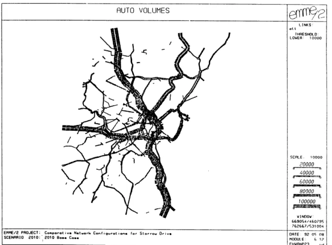
1.2-4. Figure 1.2-5. Figure Figure Figure 1.2-6. 1.2-7. 1.2-8. Figure 1.2-9.1987 AWDT Volumes in Subregion on Links With > 10,000 Vehicles...
2010 AWDT Volumes in Subregion on Links With > 10,000 V ehicles . ...
Overview of Screen "Ring" Cordon Locations ...
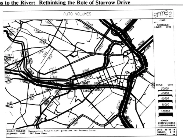
1987 AWDT Volumes in Extended Core on Links With > 5,000
V ehicles . ...
2010 AWDT Volumes in Extended Core on Links With > 5,000 V ehicles . ...
1987 AWDT Volumes on Links at Charles Circle . ... 2010 AWDT Volumes on Links at Charles Circle . ...
1987 AWDT Volumes on Links in the Arlington/Berkeley Ramp A rea . ...
2010 AWDT Volumes on Links in Arlington/Berkeley Ramp A rea . ... ... ... Figure 1.2-10.1987 AWDT Volumes on Links at Charlesgate . ... Figure 1.2-11.2010 AWDT Volumes on Links at Charlesgate . ...
Figure 1.2-12. 1987 Origins and Destinations of Storrow Drive Users -Subregion...
Figure 1.2-13.1987 Origins and Destinations of Storrow Drive Users -Extended C ore . . .... ... ... .... . ... .. .. .... . ... .... ... 17 18 21 22 29 30 31 32 33 34 35 36 36 36 37 40 41 46 47 47 54 54 55 56 56 57 58 59
Access to the River: Rethinking the Role of Storrow Drive 9 Figure Figure Figure Figure Figure Figure Figure Figure Figure 2.1-1. 2.2-1. 2.3-1. 23-2. 2.3-3. 2.3-4. 3.2-1. 3.2-2. 3.2-3. Figure 3.2-4. Figure 3.3-1. Figure 3.3-2. Figure 3.3-3. Figure Figure Figure 3.4-1. 4.1-1. 4.3-1 Figure 4.3-2. Figure 4.3-3. Figure 4.3-5. Figure 5.1-1. Figure 5.1-2. Figure 5.1-3. Figure 5.1-4. Figure 5.1-5. Figure 5.1-6. Figure 5.1-7. Figure 5.1-8.
Aerial View of Charles Circle . ...
Aerial View of the Arlington/Berkeley Street Ramp Area . ... Aerial View of Charlesgate and Harvard Bridge ...
Bird's Eye View of Charlesgate by Arthur Shurcliff, 1929 . ... F.L. Olmsted's First Published Plan for the Back Bay Fens,
1879. . .. . . . . Aerial View of the Back Bay Fens and Charlesgate, 1982... Redesign Option for Charles Circle with Depressed Mainline... View of the Longfellow Bridge from Charles Circle, 1913 . ... Possible Redesign for Charles Street Entrance from Charles
C ircle . . .... .... .. .. .... .... .... .... ... . ... . . ... .. Possible Sidewalk Design Modifications, the 'Neck Down' Principle . ...
Redesign Option for Arlington/Berkeley Ramp Area With Reverse Tunnel . ...
Redesign Option for Harvard Bridge Underpass and Integrated B ack Street . ...
"Storrow Terrace" Design Option from Boston Visions Competition, 1988 . ...
Redesign Option for Charlesgate with Tunnel Connections . ... Overview of Selected Options for Downgrading Storrow Drive.
2010 Subregion AWDT Volume Comparison: MED SCHEME
-C ase . . .... .... .... .... .... .... .... . ... ... . . ... .. 2010 Ext. Core AWDT Volume Comparison: MED SCHEME - Base C ase . . .. . . . .. . . . . .. . . . .. 2010 Ext. Core AWDT Volume Comparison: Low SCHEME - Base Case...
2010 Ext. Core Volume Comparison: FULL SCHEME - Base Case..
Network with Added Kenmore Ramps and Coded Lane C apacities . ...
Network with added Arlington/Berkeley Ramps and Coded Lane C apacities . ...
Network with Simulated Storrow - Turnpike Connector at Beacon P ark . . . .. 2010 Ext. Core AWDT Volume Comparison: TPike Upgrade
-B ase C ase . ...
2010 Study Area AWDT Volume Comparison: TPike Upgrade
-B ase C ase . ...
2010 AWDT Volumes at Kenmore Ramps with Turnpike U pgrade . ...
2010 AWDT Volumes on Arlington/Berkeley Ramps with TPike U pgrade . ...
2010 AWDT Volumes at Beacon Park with Improved Storrow Connection . ... 63 68 74 75 78 78 89 92 93 97 98 100 102 106 112 Base 119 122 127 127 138 138 139 141 143 144 145 146
Access to the River: Rethinking the Role of Storrow Drive 10 Figure 5.2-1 Figure 5.2-2. Figure 5.3-1. Figure Figure 5.3-2. 5.3-3. Figure 5.3-4. Figure 5.3-5. Figure 6.1-1. Figure 6.1-2. Figure 6.2-1. Figure Figure 6.2-2. 6.3-1.
2010 Ext. Core AWDT Volume Comparison: Parking Freeze
-B ase C ase . ...
2010 Study Area AWDT Volume Comparison: Parking Freeze -B ase C ase . ...
Circumferential Transit Concept Plan developed by the BTPR, 1972. . . . . Alignment of Circumferential Transit, Alternative 3D ...
Traffic Zone Coverage of 10-minute Walking Radius From CT Stations ...
2010 Ext. Core AWDT Volume Comparison: Circumferential
-B ase C ase . ...
2010 Study Area AWDT Volume Comparison: Circumferential -B ase C ase . ...
Air-Rights Development Option Between Kenmore Square and B U . . . .. .. . . . ... . . . .. . . . .. . . .. . . .. Kenmore Square Area Development Option from RiverVision/2020. ... . . . . .. . . . Primary Focus of Traffic Circulation Improvements from BTD Report ...
Location of Large Off-Street Parking Facilities in the Back Bay. Site Plan of Sporting Events Centers for a Boston Olympics. Figure 2.1-Al. 1987 Traffic Circulation and Peak Hour Volumes by O-D at
Charles Circle... . .. .. . .. Figure 2.1-A2. 1987 Arterial, Intersection and Sidewalk LOS at Charles Circle. Figure 2.1-A3. Key Features of the Pedestrian Environment at Charles Circle. . . Figure 3.3-Al. Design Proposal for Charles River Waterfront from Boston
Visions (1)... ...
Figure 3.3-A2. Design Proposal for Charles River Waterfront from Boston V isions (2) . ...
Figure 3.4-Al. Design Proposal for Charlesgate Entrance from Boston Visions. Figure 3.4-A2. Design Proposal for Back Bay Fens from MIT Architecture
Studio. . . . . 152 153 158 159 163 165 167 173 174 183 184 194 225 226 227 228 229 230 231
Access to the River: Rethinking the Role of Storrow Drive 11 List of Tables
Table 1.2-1. 1987 and 2010 AWDT Volumes at Selected Peripheral Spot L ocations... . ... Table 1.2-2. 1987 and 2010 AWDT Volumes at Intermediate Screen "Ring"
Locations ...
Table 1.2-3a. Counts/AWDT Volumes in Beacon Hill/Kenmore Area (1987/2010) ... ...
Table 1.2-3b. Counts/AWDT Volumes in Cambridge and Charlestown (1987/2010) ... ...
Table 1.2-4a. Counts/AWDT Volumes on the Central Artery (1987/2010) . ... Table 1.2-4b. Counts/AWDT Volumes on the Massachusetts Turnpike Table 1.2-5. Table 2.3-1. Table 4.3-1. Table 4.3-2. Table 4.3-3a. Table 4.3-3b. Table 4.3-4a. Table 4.3-4b. Table 4.3-5. 1. (1987/2010)...
Counts/AWDT Volumes on Storrow Drive/Soldiers Field Road (1987/2010) . ...
Afternoon Peak Hour LOS for Selected Intersections Near Kenmore Square . ...
2010 AWDT Volumes at Peripheral Spot Locations: Downgrading Schem es . ...
2010 AWDT Volumes at Intermediate Screen "Ring": Downgrading Schem es . ...
2010 AWDT Volumes on Central Artery: Base Case and MED SCHEME... 2010 AWDT Volumes on the Mass Turnpike: Base Case and MED
SCHEME. ...
Counts/AWDT Volumes in Beacon Hill/Kenmore (2010/MED SCHEM E) . ...
Counts/AWDT Volumes in Cambridge Charlestown (2010/MED SCHEM E) . ...
2010 AWDT Volumes on Storrow Drive: Base Case and MED
SCHEME. ...
Summary Evaluation of Long-Range Alternatives (Year 2010) .... Year 2010 Circumferential Transit (CT) Station Boardings... Daily Year 2010 CT Ridership: Unlinked Trips ...
1987 and 2010 Screenline Counts and Assignment Volumes... 4.3-A1.2010 and MED SCHEME Screenline Assignment Volumes.(1/5) . . . 5-Al. Description of Network Manipulations to Simulate Turnpike
U pgrade . ...
5-A2. Summary of Peripheral Spot Location Volumes for All
Scenarios ...
5-A3. Summary of Intermediate Screen "Ring" Volumes for All Scenarios. ... ... ... ... ...
5-A5. Calculation of Zonal Trip Reduction Based on Station Boardings. .
43 45 48 49 50 51 53 76 118 121 124 124 125 126 129 160 162 164 220 232 237 239 241 244 5.3-1. 5.3-2. 5.3-3. 1.2-A Table Table Table Table Table Table Table Table Table
INTRODUCTION
Facility of movement is one of the key determinants of economic growth in an urban area. A city will prosper if its workers and goods can be moved and information relayed efficiently between the locations of its activities. The endeavor to maximize access capacity to the employment core and between urban activity centers has consequently been a traditional centerpiece of transportation policies in metropolitan areas. The manner in which people and goods movements are conducted in an urban area, however, greatly affects the environment in which they are realized. Community disruption, loss of valuable land, visual blight, noise, air pollution and infringement upon the safety of pedestrians and bicyclists are some of the most immediate impacts suffered by those residing near the corridors of such movements. While roadways are built to connect some, they will almost always separate others. Increasing accessibility for automobiles will often decrease accessibility for pedestrians. Transportation policy decisions must therefore not only ensure that certain transportation objectives are met, but also and especially be based upon environmental, social and urban design criteria.
Storrow Drive is a sad example of how an effort to pursue one objective, improving vehicle access within Boston's metropolitan area and therefore facilitating economic growth, effected the alienation of another, enhancing a park's visual and recreational function. The Charles River Esplanade abutting Storrow Drive is one of the most beautiful and memorable pieces of Boston's urban fabric. The river park provides recreation for thousands of residents and visitors and offers one of the most exciting views of Boston's cityscape as contrasted with the natural open space. While the scenic views enjoyed by drivers on Storrow Drive gives the Esplanade some of its value, the same roadway hampers the simple enjoyment and accessibility of the park by those who reside or walk in its proximity. Portraying the ambivalent role of Storrow Drive as a link, on the one hand, and a barrier, on the other, is the object of Part I of this thesis.
Access to the River: Rethinkin2 the Role of Storrow Drive
The impact of highways on the quality of the urban living experience calls for a changed role of urban transportation planning. Instead of merely providing for the accommodation of mobility demands associated with the functioning of the urban system, transportation planning here is proposed to play a pro-active role. Automobile trips are not treated as predetermined quantities but rather as functions of specific policy measures. This approach reverses the sequential hierarchy of the planning process traditionally applied. Whereas today we look for environmental design measures best mitigating the negative effects of a given planned transportation project, the intent here is to formulate the environmental/urban design improvement as the primary policy goal and then find measures which minimize its negative transportation impact. This approach has the advantage that it recognizes the health of the urban environment as the essence of any kind of planning in a city where people live and work. The revitalization of the park system, promotion of pedestrian circulation, improvement of urban links and expansion of the role of transit serve as the basis for formulating options regarding the many possible futures of Storrow Drive which are explored in Part II. Through the insertion of some specific detail on options at important nodes along Storrow Drive, the analysis seeks to focus the discussion by conceptualizing how these general ideas could be translated into specific actions in situ.
The realization of concepts explored in Part II depends on a variety of factors. One is the application of policies which would complement the objective pursued in downgrading Storrow Drive. A set of sensitivity analyses seeks to address the question of how the transportation impact of envisioned environmental improvements could be mitigated through the application of specific policies. A second is the compatibility of the envisioned environmental improvement with other objectives of residents, businesses and policy makers. An assessment of which positions are held by members of the affected parties serves as an initial measure of support for a downgrading of Storrow Drive. A third factor is the timeliness of the proposal. At a time where the largest public works project in the history of the Commonwealth, the Central Artery/Third Harbor Tunnel (CA/T) project, is nearing its inception, there is a unique opportunity to write a new chapter in Boston's urban transportation history. Designed to remove a central
Access to the River: Rethinking the Role of Storrow Drive 14 bottleneck and traffic from local and arterial streets in its vicinity, the CA/T project provides a timely occasion to think about how to best reap these benefits. Coinciding with this event is the passage of an innovative piece of national legislation, the Intermodal Surface Transportation Efficiency Act of 1991, which could further lead the way to massive improvements in public transportation and the pedestrian environment. A discussion of these linkages is the object of Part III.
Considering both the uniqueness of this coincidence and the continuing need to improve the quality of Boston's urban environment, the ideas put forth for Storrow Drive should serve as a basis to promote a vigorous and sincere participatory discussion about how these benefits could best be translated into local improvements for communities
elsewhere.
As a result, this paper hopes to give a taste of Boston's potential to reclaim some of its "lost" urban space. It will generate a framework for the formulation of future transportation policy objectives by providing a sense of what policy makers can do and should do in this time of changing environmental priorities.
BACKGROUND
PARKS, PEOPLE, PROGRESS
AND THE ADVENT OF THE AUTOMOBILE
The Esplanade and Storrow Drive have four distinctive yet interwoven histories. First, the transformation of the former estuary and creation of the Back Bay is the foundation for the geographical topography of the Charles River Basin which has lasted until this day. Second, the park movement which evolved around the last quarter of the 19th century was one of the main forces behind creating and integrating the basin and
Access to the River: Rethinking the Role of Storrow Drive 16 other contiguous land into an urban park system. Third, the development of the
Esplanade is a direct consequence of these influences. If the damming of the river initially yielded the technical potential to develop the basin at all, it was the landscape architects, prominent visionaries and motivated citizens who were the ultimate leaders in creating the park environment which became reality. Finally, during the postwar period the river basin's environment was radically transformed to suit the needs of automobiles. The Storrow Drive Expressway itself and interchanges along its length are some of the
traces this encroachment has left until today.
The Creation of the Charles River Basin
Less than two centuries ago, what today we call the Charles River Basin was a large estuary extending to Watertown twice a day and expanding and contracting with the tide of the sea (Figure B-1).1 When Captain John Smith explored the waters in 1614, he named it after his patron, Prince Charles of England, because it was so wide in its lower part that he believed it was a grand river.2 The bay was bounded by the Boston Common to the East, Washington Street to the South, Sewell's Point, now Kenmore Square, to the West and almost what is known today as Central Square to the North. In 1821, the Mill Dam was completed, connecting Boston Proper, which at that time extended to about Charles Street on the West, to Sewell's Point. This historic toll road is the Beacon Street of today. In addition to serving as a connector between formerly separated parts of the region, the dam was used to capture tidal power to run mills along its embankment.
The dam had a dramatic impact on the sensitive estuarine ecology in that it prevented tidal currents from cleaning out accumulating sewage released into the receiving basin by the growing city. In 1849, the Back Bay was regarded "nothing less than a cesspool" by the Boston City Council, an odoriferous dump posing a sanitary threat to the citizens during low tide.3 In the following years, demands that the city or state ameliorate the situation grew, especially by those who couldn't afford to leave the city in the summer.4
Access to the River: Rethinking the Role of Storrow Drive 17
*r
4,
as 4* - -
-Figure B-1. A Plan of Boston With Environs by Henry Peiham, 1777.
A compromise between the city, the state and the owners of the mill dam was reached in 1856 when the state gained ownership of the predominant portion of land to the south of the dam and the mill owners received development rights for one row of houses along the north side of the dam.5 Years later, during the planning stages for construction of the Charles River Dam, proposals to add another row of town houses fronting on the basin were repeatedly opposed by the wealthy owners of North Beacon
Access to the River: Rethinking the Role of Storrow Drive 18 Street residences as they would have blocked their view on the river. This is why the Back Bay until this day still backs, rather than faces the Charles River Basin.'
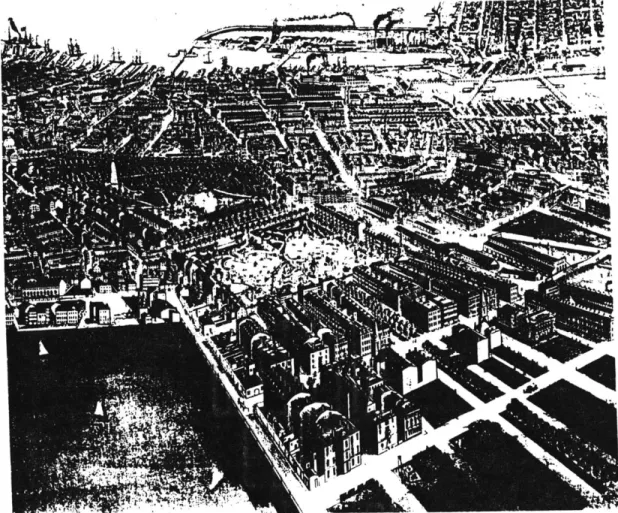
As a result of the agreement reached and backed by the need to accommodate a rapidly growing population, the muddy and shallow Back Bay receiving basin was filled between 1859 and 1877 between Charles Street on the East and the Fenway in the West.! Construction proceeded rapidly and the Back Bay in the layout we find today was completed almost simultaneously with the filling of the mudflats as is shown in Figure B-2. Quickly, the Back Bay became a fashionable place to live for wealthy Bostonians who moved out of their crowded residences in the 'old' city."'9 With the construction of the Charles River Dam in 1910, the Charles River completed its transformation from an open salt water estuary to a contained freshwater receptacle. The Charles River Basin was born.
Access to the River: Rethinking the Role of Storrow Drive 19 The Park Movement
The urban landscape of eastern metropolitan cities was radically transformed during the 19th century through massive urbanization and industrialization. These changes led to dramatically increased demands on sanitation, housing and traffic circulation.'" As more and more land was devoured to construct infrastructure necessary to support these demands, spaces to escape congestion and pollution associated with the city were becoming increasingly scarce.
With the advent of public transportation, residences in more rural settings along the periphery of the city became increasingly popular. At the same time, land values in the urban core began rising sharply and private open space amenities in the central city vanished at an accelerating rate. Boston compared quite unfavorably with other cities, such as New York, Chicago and Philadelphia, in terms of acreage of public open space." The need to have more open space available to the public, as well as the concurrent and growing desire to "return to closer harmony with nature" stimulated by writings of George B. Emerson and Henry D. Thoreau, promoted the formation of an urban park movement by the mid-1800s.1'
As the Back Bay and other parts of the city grew, enthusiasm for new parks increased." In November 1869, Boston had its first major public hearing on the parks issue. One of the guiding objectives was accessibility. Most favored a series of small parks in the vicinity of many of the common people and many argued, that the parks should serve those not wealthy enough to reach the more remote sites in the countryside.
The Mayor of Boston appointed a Park Commission in 1875 which made its first report the following year, proposing a park system linking the Charles River, parts of the Back Bay, Parker Hill, South Bay, Savin Hill, City Point, East Boston, Chestnut Hill, Jamaica Pond, and West Roxbury. Soon after the release of the report a public meeting named "Parks for People" was held at Faneuil Hall. A year later, in 1877, a first appropriation of nearly $1,000,000 was made by the city council.
Access to the River: Rethinking the Role of Storrow Drive 20 Boston's 'Emerald Necklace', a park system designed by Frederick Law Olmsted who had gained national recognition through his design of New York's Central Park. Commonwealth Avenue, which had been laid out as part of the Back Bay residential district, and the Public Garden, completed in 1860, were integrated into the park system and parkways, such as the Fenway, Riverway, Jamaicaway and Arborway, served as landscaped connectors between the major parks.6
In 1893, the Metropolitan Park Commission (MPC) was founded which, along with other public agencies, acquired most of the parcels lining the Charles River." As a result of a commissioned MPC study investigating the sanitary condition of the Charles River, discussions about whether to construct a dam across the mouth of the Charles River flared up. Several concerns were voiced about the possible silting up of Boston Harbor and the spreading of malaria with a fresh water basin. Some pointed out that industry needed the river access for transporting shipments by water." After years of controversy, however, work on the Charles River Dam was begun and completed in 1910.
The Making of the Esplanade
The Charles River was at the heart of the earliest proposals for a connected series of parks. One of the first people to recognize the Charles River's potential as a public open space asset was Robert Gourlay, a Scottish visionary who proposed that the river be lined with parks and pleasure drives.19 Charles Eliot believed that the Charles River Basin "was destined to become the central 'court of honor' of the metropolitan district" and the focal point of the entire park system.20 U.H. Crocker and Charles Davenport had recommended a landscaped embankment along the river even before the 1876 park commissioners' report but it was only in the last years of that century that seawalls were constructed along the Boston shore to increase public open space along the river.2'
However, the newly created banks on both sides of the river were not developed because of uncertainty regarding the construction of the "Riverbank Subway" and because of opposition from North Beacon Street residents.22 These property owners were also some of the fiercest opponents of the dam construction at the mouth of the Charles River.
Access to the River: Rethinking the Role of Storrow Drive 21 Several schemes had proposed the construction of a row of houses fronting on the basin which would have blocked the river view then enjoyed by water side residents.23 The outcome was split in that the dam was finally built but the town house construction schemes dropped.
As the newly created basin was not successful in attracting people for leisurely activities?, several plans, including islands in the Charles, were developed over the following years to increase the basin's appeal. The first stage was the construction of Charlesbank Park in the West End around 1890. It was the first park to be completed in the park system designed by Frederick Law Olmsted. The second stage was the filling of the Charles River between Longfellow Bridge to Charlesgate West at about the time when the dam was built. Embankment Road was laid out as a parkway along the eastern portion of this newly created strip, connecting Beacon and Cambridge Streets. The third stage saw the construction of landscaped edges along the river with little islands and a lagoon, as shown in Figure B-3.2 The park was designed by Arthur Shurcliff in the 1930s and modeled after the Innen Alster Basin in Hamburg, Germany, which had inspired the landscape architect on his recent trip to Europe.26 Helen Storrow, the widow of James J. Storrow who had been active in getting the dam built, donated one
hdL
Access to the River: Rethinking the Role of Storrow Drive 22 million dollars - over a quarter of the total cost - to aid the development of a riverfront park in memory of her late husband.27 When the park was completed in the mid-1930s it was named Storrow Memorial Embankment, in memory of its key benefactor, and became what we know today as the River Esplanade, which can be seen in Figure B-4.
Vt ~t
... -- ~ -- d
-4
Figure B-4. Perspective of the Charles River Basin, 1929.
Yielding to the Automobile
The establishment of the Esplanade was preceded by years of battles over the construction of a highway on the parkland. In 1929, the recently appointed Special Commission on the Charles River Basin published a report proposing an integrated park and roadway design. The report highlighted that motorists were also park users and that the rather inconspicuous roadway would do little to lessen the enjoyment of the park by pedestrians.28 Although suggestions for roadways along the Charles River embankments dated back as far as the early BPC reports and had been supported by Charles Eliot and
Access to the River: Rethinking the Role of Storrow Drive 23 others in the 1890s, there was substantial opposition to these schemes by the 1920s.29
In a time where cars began replacing trams and carriages as a means of transportation, the role of automobile traffic had changed to such a degree as to dictate the scheme of park design rather than being integrated into it.30 After an organized battle against the
parkway the road construction was eliminated as part of the park proposal."
In spite of the cancellation of the highway plan along the embankment, the city and state continued financing studies supporting the construction of such a roadway. Only a year after the 1929 defeat in the legislature, the Report on a Thoroughfare Plan
for Boston, more widely known as the "Whitten Report," renewed the idea of a roadway
along the south shore of the Charles River. The Whitten Report marks the beginning of a transportation planning approach which became prevalent in the 1950s and 60s. The guiding principle was the provision for "free and continuous movement of traffic [..],
relief for congestion and capacity for increases" in the future." Costs of expressway construction were waged against economic benefits deriving from travel time savings and fewer accidents as well as against advancements in the comfort of travel. In order to minimize costs, selected locations for rights-of-way were typically through low-income neighborhoods or public land, often parks, a trend quite visible with road construction schemes in the early postwar years. Environmental and social costs were words of a vocabulary yet to be invented. The report was explicit about stating the dependence of economic prosperity on time- and cost-efficient access between activity points within the metropolitan area.M
The automobile was viewed as the harbinger to an era of radically expanding mobility, a quantum leap from the fixed patterns of travel supported by the transit system." The Whitten Report suggested that highway infrastructure needed to be improved so that the city could realize the advantages of automobile transportation.
"The art of street design and construction has lagged far behind the art of vehicle design and construction. As a result, the citizens and businessmen of metropolitan Boston are denied the full advantage of one of the most marvelous developments of the age, the motor vehicle."31
Access to the River: Rethinking the Role of Storrow Drive 24 prototype to run along the river embankment, the Master Highway Plan of 1948 got down to business proposing a "six-lane divided highway of modified limited access design for the use of passenger automobiles.""7 By linking what was then called the Embankment Road Extension to the Central Artery-to-be and Inner Belt-not-to-be and by limiting access and egress points along its alignment, the roadway for the first time was designed as a regional highway link rather than a major parkway such as those girdling the Fenway and Muddy River parks.
Although the Metropolitan District Commission (MDC), a 1919 merger of the Metropolitan Parks and Metropolitan Water and Sewer Commissions, had declared the construction of a highway through the only decade-old Storrow Memorial Embankment to be a "criminal act," it was under their ownership, acquired in 1947, that the highway plans were refined and finally acted upon.38 The MDC's added responsibilities, primarily in the area of traffic and parking enforcement, led to a reduced commitment to maintain the parks owned by them.39 The highway proponents, supported by former MDC Commissioner Senator Bowker**, real estate leaders and the Greater Boston Development Committee, argued that there were strong travel "desire lines" paralleling the Charles River which necessitated the construction of additional capacity along this corridor. The Storrow Memorial Embankment Protective Association, founded in 1948, however, claimed that demand from the West was strongest along an alignment closer to Boylston Street.4
1 Nevertheless, committee members, neighborhood residents and
activists during the planning phases for the embankment park, could not prevent the passage of the roadway bill in April 1949. With both James and Helen Storrow dead, the roadway opponents had lost two of their most prominent figures and ultimately the park versus freeway battle. Between 1949 and 1951 James J. Storrow Memorial Drive, ironically named after one of its fiercest opponents, was built on the land of the former Memorial Embankment. As compensation, the parkland taken by the new expressway was replaced by an equal amount of new filled river park in the form of little connected islands complementing the former single lagoon.42
The Bowker Overpass, constructed in 1965, is the last in the series of infringements upon the Esplanade and its adjacent parks. After the construction of a
Access to the River: Rethinking the Role of Storrow Drive 25
complicated agglomeration of loops and viaducts at Charles Circle and the completion of high-speed off-ramps from the embankment highway at Arlington Street, a third vital connection to the Esplanade, the Fenway, was now severed. The Emerald Necklace had become brittle.
PART I
A
PORTRAIT OF STORROW DRIVE
Understanding the evolution of the Back Bay and Storrow Drive reveals some of the historical controversies surrounding the balance between mobility growth, economic prosperity and the provision of open space. This section of the thesis deals explicitly is one of these, the conflict created by transportation's ambiguous role as both a linkage and a barrier.
Transportation facilities, such as the highway and rail networks, serve to connect people to the locations of their choice. The health and growth of a city depends on a system of efficient linkages which allows for the efficient movement of people and goods. The ability to travel contributes positively to the quality of life in a city.
One of the exciting features of a city such as Boston is its "walkability." Unlike many other settlements in the United States, Boston's scale and land use mix in the vicinity of downtown are some of the primary reasons why walking is so popular and pervasive. In the same ways that the efficient movement of vehicles requires a system of coherent links which are sufficiently sized and interconnected, pedestrians are dependent on such linkages to maintain access to destination points of their choice.
The density of cities typically results in a conflict between achieving adequate mobility for both vehicular and pedestrian travel. Unfortunately, the need to resolve this conflict has often resulted in a hierarchy which benefitted vehicular at the cost of pedestrian mobility. Storrow Drive reflects this hierarchy. While a preferred route by many motorists because of the magnificent views it affords, access to the Esplanade, one of the most vital open space resources in the city and frequent destination for residents of the Back Bay and Beacon Hill, has been severely curtailed through the construction of this limited-access, high-speed expressway.
Storrow Drive, like many other transportation links in the city, dons two hats. One is described in Chapter 1 which provides an overview of vehicular movements and
their distribution in Boston and abutting towns with particular focus on the role of Storrow Drive in both the regional and local context. The conflict of vehicular and pedestrian movements at locations along Storrow Drive and its special relation to open
Access to the River: Rethinking the Role of Storrow Drive 28
Chapter 1
Transportation As Linkage
System Connectivity and Vehicular Movement
This chapter serves to provide a synopsis of the pattern of vehicular movements in the Boston area. While transit is the principal travel mode for a majority of trips between some areas in the urban core, this paper focusses on the discussion of auto trips. The reason for this is that the quantitative analysis of traffic impacts associated with network changes, as will be discussed in Part II, seeks to address the question of how travel by automobile is affected by the configuration of Storrow Drive. The complementary role of transit is always implied and important modal relationships are
specifically highlighted and integrated in Part III.
The model network was provided by the Central Transportation Planning Staff and represents a condensed subarea version of CTPS's 877-zone regional model. A description of the this network, the development of a methodology to differentiate between geographic "layers" for analysis, and an overview of road and transit facilities which serve travelers in the Boston area are in section one.
The second section, after a brief discussion of the assignment process, summarizes the results of traffic assignments for the 1987 base year and the future analysis year 2010. Important features of automobile travel in the subregion, an area to be defined below, are discussed with particular focus on the transportation function served by Storrow Drive in both a regional and local context.
1.1. Transportation Network
1.1.1. Model Network and Analysis Areas
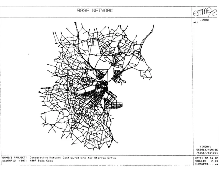
The model network used in this paper is a subarea of the CTPS 877-zone Regional Model. Initially prepared for MetroPlan 2000 in 1990, the network covers an area extending a little more than halfway to Route 128, a highway circumferential located
Access to the River: Rethinking the Role of Storrow Drive 29 approximately 10 miles from downtown Boston. Trips to and from locations outside of this area are represented as external nodes which connect to the 283-zone model network via 65 links at the periphery. Thus, the complete 348-zone model accounts for all trips which have at least one trip end in the designated subarea. A map of towns in Figure 1.1-1 shows the location and size of this area relative to Eastern Massachusetts. The area corresponds to the MPO Commuter Source Area which encompasses the residences of virtually all people who commute to Boston on a daily basis." The model network, depicted in Figure 1.1-2, includes the towns of Boston, Brookline, Cambridge, Somerville, Malden, Everett, Medford, Chelsea, Revere and Winthrop.
Access to the River: Rethinking the Role of Storrow Drive 30
BASE NETWORK
c4Ofp/
LINKS:
WINDOV:
GG9054/460795 762667/531004 EMME/2 PROJECT: Comparat ive Network ConrfIguation.a ror Storre. Drive DATE: 32 04 1
SCENARIO 1987: 1987 Basoe Come MODULE: E. 13
____ _________FHWANP23.. .pd
Figure 1.1-2. 283-Zone Subregional Model Network With Boundaries of Analysis Areas.
The distinction between several layers of the transportation system is a useful analytical step. Varying the geographic scope helps to focus on different elements of the highway system, such as hierarchical structure, complementarity and local distribution characteristics.
In this study, the largest area is referred to as the subregion which corresponds to the 283-zone subarea of the region. The subregion serves primarily as a wider-scope system reference for the study area and its boundaries coincide with those of the model network as shown in Figure 1.1-2.
Access to the River: Rethinking the Role of Storrow Drive 31
Central Square in Cambridge to the North, Beacon Park to the West, the Fenway to the South and Boston Harbor to the East (Figure 1.1-3). This area contains all arterials and highways which are adjacent or parallel to Storrow Drive and seems thus a plausible scale to measure the most immediate automobile traffic impacts of proposed study area network changes as will be seen in Chapter 5.
EMME/2 PROJECT: Compra Networ. Con ,gurot ions for Storrow Driv
SCENRI0 1987: 19837 B... Co...
Figure 1.1-3. Extended Core Analysis Area Model Network With Study Area Boundaries.
Finally, the Storrow Drive study area itself extends from Charlesgate to the West to Leverett Circle in the Northeast and is shown in Figure 1.1-4. All examined network modification options are limited to occur within these boundaries. Within the study area three focal locations - Charles Circle, the Arlington/Berkeley ramp area and Charlesgate
Access to the River: Rethinking the Role of Storrow Drive 32
Figure 1.1-4. Study Area Model Network: Leverett Circle to Charlesgate.
1.1.2. Facilities
The facilities serving these movements are the underlying grid of the transportation system. Figure 1.1-5 shows a roadway map of the subregion. It shows that Boston has a typical radial highway system with few circumferential connections within Route 128. Access from the Southeast occurs primarily via the Southeast Expressway (1-93 South) and major arterials such as Route 28 South and Dorchester Avenue. From the Southwest, vehicles could use either the Worcester Turnpike (Route 9) or major arterials, such as Beacon Street or parkways lining the Emerald Necklace. The Massachusetts Turnpike is a major transportation corridor extending to the West and supported by several smaller
Access to the River: Rethinking the Role of Storrow Drive 33 8I.Aa@ ~ O ISLAND b 10
0
B a y LOG / RK ILN SLA OCN ,K'IIF
R
IS AN N . ~4 h r n H n g S A \ y a chFigure 1.1-5. Roadway Map of Boston and Vicinity.
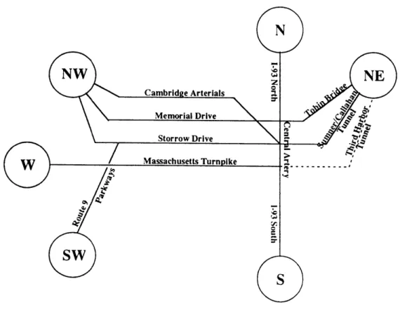
arterials most of which feed into Soldiers Field Road and Memorial Drive further in. In the Northwest, Route 2 and Cambridge arterials such as Concord and Massachusetts Avenue represent the most important roadway corridors as do I-93 and Route 28 to the North. Finally, Routes 1 and 1A are the principal highway connections to the Northeast. Principal highway and arterial connections to Boston within the subregional system are schematically depicted in Figure 1.1-6.
Access to the River: Rethinking the Role of Storrow Drive 34
, Route 1A North
South
Figure 1.1-6. Schematic Overview of Principal Road Connections in Subregion.
Within the extended core area, it is useful to distinguish between primary and secondary highways. The primary highways are the Central Artery, the Massachusetts Turnpike, McGrath Highway and Storrow Drive. These are limited-access facilities without or with little signal control which have very high capacities. The second group comprises of major arterials such as Somerville and Massachusetts Avenue, Cambridge Street, Broadway and Memorial Drive in Cambridge, and Brookline and Beacon Streets, Huntington Avenue, Tremont Street and the Fenway in Boston. For clarity, these are again shown in a schematic overview in Figure 1.1-7.
Storrow Drive is a limited-access, six-lane highway within the study area and four lanes wide further to the West. It connects suburbs in the West and Northwest via Route 2 and other arterials, suburbs in the South and Southwest via the parkways and Route 9, as well as activity centers in the Back Bay, Beacon Hill, Government Center and other downtown locations with the Interstate system at Beacon Park, the 1-90 West linkage, and
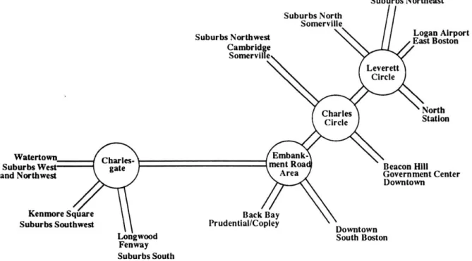
Access to the River: Rethinking the Role of Storrow Drive 35 at Leverett Circle, the 1-93 linkage. The principal nodes at which these connections occur are the interchange at Soldiers Field, Beacon Park, Charlesgate, the Arlington/Berkeley ramp area, Charles and Leverett Circle, the latter four of which are included in the study area. The schematic diagram in Figure 1.1-8 shows which areas are served by Storrow Drive and the nodes at which they occur. With the ongoing debate about a design for the proposed, river crossing, and exploration of improvement possibilities of the Allston Interchange at Beacon Park, the study area lies in between two areas which will undergo substantial transformation over the next years.
Figure 1.1-7. Schematic Overview of Principal Road Connections in Extended Core.
On the transit side, Figures 1.1-9a and 1.1-9b give an overview of the subregional rapid transit and commuter rail system. The Massachusetts Bay Transportation Authority operates four rapid transit lines, the Red, Blue, Green and Orange lines, as well as ten commuter rail branches out of North and South Station in Boston. A closer view of
Access to the River: Rethinking the Role of Storrow Drive 36 Suburbs Northwest North Station Suburbs Wet and Northwest Kenmore Square Suburbs Southwest Beacon Hill Government Center Downtown Back Bay Prudential/Copley
Longwood South Boston
Fenway Suburbs South
Figure 1.1-8. Schematic Overview of Study Area And Identification of Key Nodes.
OAg g WONEnt.ANC
ALEWERM MALDEN CENTER REVERE REACO
OAVS WELLINGTON REACNMMONT
.ORTER SULLIVAN SQUARE SUFFOLK DOWNS
LECRMBRn -ORIENT HEIGHTS
.AvARO SCIENCE PARK COMMUNITY WOOO ISLAND
CENTRAL NORTHMSTATIO A AIRPORT RAPID
KCENDALL MAYMARKET MAVERICK TRANSIT
,,,,..( CHARLESIMGM AQUARIUM LINES
GOVERNMENT Cin STATE
PAR STREET 00WNOWS CROSSING
BOVLSTON CINATOWN SOUTH STATION ARLINGTON NE MEDICAL BROADWAY
COPLEY BACK BATISOUTR END ANDREW
AUOITORIUEM PRUENTIAL MASSACHUSETTS AVE .FKIUMASS
CENMORE SYMONDNY AUGOLES
BOSTON UNIVERSITV
NORTHEASTERN ROXRIRT CROSSING
BOSTON
COLLEGE
E MUSEUM -ACKSON SOUARE
CLEVKLANO SAVIN
C AVE RIEMAM STONT K11014
C AE CaIRCLE FIELDS
RVtSRIUE RESERVOIR MEATM GREEN STREET COOA
O SOAVIMUT 0AASCB
.5FOINEST ERiLLS WIOL LASTON
ARMORAV 1 AONMLOT
RAPID TRANSIT LINES a
OU.%CV
COMMUTER RAIL LINES = CENTER
ADAMS
WINAMTPEE
Figure 1.1-9a. MBTA Rapid Transit Li
CONCot D RD'.IMM
ME CAND OC IME
CONCORD A EDOU vHL'OII
ML.E,L.,, EEEK -UED oa RnEUBI WS E RE
RIELV OnUETN aDENLA . MNTER CEENTTR
PENA I ORTE SGRU4UDE YAWE STAT SMU
DEON AVELE R
ieC.,
ZuE LHELLS
.EsT iCK 9eLLEVUgK -G0
'vesinossal, "EADtuA EEDM.AMvC mW0OTT MEE~saau.CENT" s0ouE mfTI0Aom nes. saaoaE I TN OcE
RAgEg NBI.MREERRL ROCAPORT
ANDOVER MU ItE U
MACESL 0EBRRCI DE E
""AN000c IPSCWICH~ I"~ns. BVN~au - 1--- ... rco.... ,E
CMAD PAK Igga Sgge Na ERA NN* BACTKO .9
/0A"sT
Pos OMTAN siCAETC $10M12" "*"M COMMUTER RAIL LINES CAftriNsIic CANT0.CElTER sTOUGNTOGMAccess to the River: Rethinking the Role of Storrow Drive 37 transit alternatives in the adjacency of the study area are shown in Figure 1.1-10. As is evident from this graphic, all bus, rapid transit and commuter lines are located close to the commercial area on the southern end of the Back Bay. Not depicted in this figure are the rapid transit Red Line connection at Charles and the Green Line connection at Leverett Circle.
Figure 1.1-10. Overview of Public Transit Facilities in the Back Bay.
1.2. Automobile Travel
This section summarizes the results of traffic assignments performed on the 1987 and 2010 network with the respective trip tables. A brief discussion of the assignment process and underlying assumptions is followed by a graphic, tabular and written description of vehicular traffic volumes on the three analysis levels and changes occurring between 1987 and 2010.
1.2.1. Trip Tables and Network Equilibrium Assignments
The trip tables, which means the sum of all trips to all origins within the 348-zone network - 283 zones in the subregion and 65 external nodes - were generated by CTPS from the 877-zone Regional Model with a subarea extraction program which aggregates