Publisher’s version / Version de l'éditeur:
American Railway Engineering Association Bulletin, 60, 549, pp. 669-688,
1959-06-01
READ THESE TERMS AND CONDITIONS CAREFULLY BEFORE USING THIS WEBSITE.
https://nrc-publications.canada.ca/eng/copyright
Vous avez des questions? Nous pouvons vous aider. Pour communiquer directement avec un auteur, consultez la
première page de la revue dans laquelle son article a été publié afin de trouver ses coordonnées. Si vous n’arrivez
pas à les repérer, communiquez avec nous à PublicationsArchive-ArchivesPublications@nrc-cnrc.gc.ca.
Questions? Contact the NRC Publications Archive team at
PublicationsArchive-ArchivesPublications@nrc-cnrc.gc.ca. If you wish to email the authors directly, please see the
first page of the publication for their contact information.
NRC Publications Archive
Archives des publications du CNRC
This publication could be one of several versions: author’s original, accepted manuscript or the publisher’s version. /
La version de cette publication peut être l’une des suivantes : la version prépublication de l’auteur, la version
acceptée du manuscrit ou la version de l’éditeur.
Access and use of this website and the material on it are subject to the Terms and Conditions set forth at
Soil engineering problems on the Quebec north shore and Labrador
railway
Woods, K. B.; Pryer, R. W. J.; Eden, W. J.
https://publications-cnrc.canada.ca/fra/droits
L’accès à ce site Web et l’utilisation de son contenu sont assujettis aux conditions présentées dans le site
LISEZ CES CONDITIONS ATTENTIVEMENT AVANT D’UTILISER CE SITE WEB.
NRC Publications Record / Notice d'Archives des publications de CNRC:
https://nrc-publications.canada.ca/eng/view/object/?id=e527d1fd-f59c-4f2d-b869-c5a022f4369b
https://publications-cnrc.canada.ca/fra/voir/objet/?id=e527d1fd-f59c-4f2d-b869-c5a022f4369b
8er
rHl
N21t2
no. ?2
"
c . 2
BI,DG
]
NerroNll ReseancH Couxctu
CANADA
DIVISION OF BUILDING RESEARCH
A N A L Y Z E D
SOIL ENGINEERING
PROBLEMS
ON
THE QUEBEC NORTH SHORE AND LABRADOR RAILWAY
BY
K. B. WOODS. R. W. J. PRYER AND W. J. EDEN
REPRINTED FROM
AMERIcAN RArLwAy ENGTNEERTNG
AssocrATroN i{r*rrr.l,
ppgc66}tN}es
vol-. 60, NO. 549, FEBRUARY 1959. P. 669 - 644.
T E C H N I C A L P A P E R N O . 7 2 O F T H E
DIVISION OF BUILDING RESEARCH
OTTAWA
J U N E 1 9 5 9
PRICE 25 CENTS N R C 5 t 9 3
Thls publlcatlon
is
belng dlstrtbuted
bt
the Dlvtslon of Bulldtng
Research of the Natlonal
Research Councll as a contributlon
towards better
bulldlng in Canada. It should not be reproduced
ln whole or in part, without pernisslon of the
orl-glnal publlsher.
The Dlvlslon would be gLad to be
of asstetance in obtaining such pertlsslon.
Publlcatione
of the Dlvlslon
of Bul1dlng
Research nay be obtalned by rnalllng the approprlate
reurlttance,
(a Bank, Express, or Post Office liloney
0rder
or a cheque rnade payable at par ln Ottawat
to the Receiver
General of Canada, crsdlt Natl,ona1
Research Counctl) to the Natlonal Research Council,
Ottawa. Stanps are not acceptable.
A coupon sSrstem has been lntroduced
to
nake pa;ments for publlcatlons
relatively
elmple.
Coupons are avallable
ln denourlnatlons of
5, 25t
and 50 cents,
and may be obtaLned by uraklng a
re-nrlttance as lrdlcated
abore.
These coupons rnay be
used for
the purchase of all National
Besearch
Councll- pubLLcatlons includlng
speclflcatlons
of
the Canadian Gorrerrunent Speciflcatlons
Board.
t'r
R o a d w a y a n d B a l l a s t 669
Soil Engineering Problems on the Quebec North Shore
& Labrador Railway
By K. B. Woods,* R. W. J. Pryer,x* W. J. Eden***
A. SYNOPSIS
The construction of a 360-mile railroad to reach the iron-ore deposits in Quebec-Labrador in terrain virtually unknown could be expected to r,aise serious problems with respect to soil conditions. The climate of the region imposed another set of difEculties because the winters are severe and the short summer season is cool with frequent rain-fall. This paper points out the diffrculties that w,ere caused by soil conditions and sets forth some of the measures taken to remedy the situation.
slope stability in banded clays was a serious problem in the fust 30 miles. Because of the climabe, frost action was a major consideration throughout the length of the line. construction problems were mainly caused by loose, saturated soils with very poor natural drainage, and frequent rainfall in the summer months.
B. INTRODUCTION
Few engineering projects in reoent years have matched the scale of the iron-ore development in Quebec-Labrador. A major phase of this undertaking was the con-struction of the Quebec North Shore & Labrador Railway between the rich iron-ore deposits of the Schefferville area and the tidewater docks at Sept Iles. This paper summarizes some of the soil engineering problems encountered in this undertaking and discusses methods used to solve the difficulties encountered.
The railway, a single-track line, is based at tidewater 1 mile east of the town of Sept fles on the north shore of the Gulf of St. Lawrence, and some 484 miles northeast of Montreal. Schefferville (El. 1700), the northern terminus, is almost due north o,f Sept Iles, a distance of 358 miles by rail. The terrain traversed by the railway (Fig. t) may be describ,ed generally as the Laurentian Plateau of the Canadian Shield, but a number of different geological and soil formations are encountered, each one raising problems peculiar to the location.
Reconnaissance and aerial surveys were undertaken in 1945 and 1946 (l)f and preliminary lines run during the following two years. rn 1949, optimum train lengths, weights and speeds having been established, final location surveys were begun. Con-struction commenced in late 1950 (2) and track laying was completed in February 1954. A total of 21 million cu yd of excavation was required,6 million cu yd being involved in the construction of haulage roads and 1l intermediate airstrips between those at Sept Iles and Schefferville.
* Head, Civil Engineering Department, Purdue University. ** Soils engineer, Quebec North Shore & Labrador Railway.
*x* Division of Building Reseach, Natioual Research Council, Cmada. t Numbers in paenthesis refer to references at end of report.
I'l
R o a d w a y a n d B a l l a s tI
s
f
\
QUEBEC
I I I I I It&nihek Lole\ :
\i
,
\ , ,
--
5i-| 6tt'-
-,
6Po. \
I Ashrnipi L! \\-v.1
t1iY,r" ^'t.)
ltl_,:-
*,-..
,
Trt
-r. ^(,,
Z.\
)t
(
t\
\
t-.
:_:7: 1.Qoi;o;v t lGulf of.l.uSt Lowrence I .
r..-
/ \
200\
(
Ash[l:9-s
LABRADOR
LAKE PLATEAU a ( '(
\ )
\
- 5 ? .taaaaoon \
TROU6H
Mds L M P s O d[yy;YY-!*#!"i)-Fic. l-Physiographic-map
-of L-abrador Peninsula_ showing-locat-ion
of
- -''r"il*-.y'(adapiea
R o a d w a y a n d B a l l a s t
6 ? r
7 0 6 0 50 4 0 5020
r o
8 0 7 0 60 U E t F 5 0 t tlj a 4 0 2 lrJ F > 3 0 J -F ? 2 0 g=
? r o
U=
o
- t o
-20
- t o
-20
t 2 M E A N M O N T H L YS E V E N I S L A N D S
K N O B L A K E
Fig. 2-Composite
L A T .
T O T A L P R E C I P I T A T I O N ( I N C H E S } 5 0 " - l O N L O N G . 6 6 0 - l 5 W ( r r v e r a s R E c o R o s ) L A T . 5 4 " - 4 0 N L O N G . 6 6 9 - 5 5 W t r o y E A R s R E c o R o s ) hythergraph of Knob Lake and Seven Islands.C . C L I M A T E
The climate of the region varies f rom maritime at sept Iles to sub-arctic at schefferville (3). Fig 2 shows hythergraphs for schefferviltre and Sept Iles by which lhe climates may be compared in terms of mean monthly temperature and precipitation. The coastal region is one of relatively high precipitation, the average annual p.".ipit"tiott at Sept Iles being 42 in. The heaviest monthly rainfall is close to 6 in and occurs generally in July. A second peak of precipitation occurs during the winter months when saturated air from the Gulf of St. Lawrence comes into contact with the steep slopes of the north shore. Annual snowfall is of the order of 170 in, while the heaviest monthly snowfall averages 50 in and occurs usually in January. On the Labrador Plateau (or in the region north of Mile Post 100) precipitation is more moderate. At Schefferville, the average annual precipitatiOh is 28 in, of which rainfall
N O B LAKE _
d-- . ? t (^\
A \ I I t t ' .I
I l n f\
E V E I,
$.t l t s L N O S -o Jo l z R o a d w a y a n d B a l l a s t
accounts for slightly more than one-half. The heaviest monthly rainfall amounts to 3.5 in and occurs in J,uly and August, the only months during which snowfall is
neg-ligible. Annual snowfall is approximately 130 in, most of which is fairly evenly
dis-tributed over the months from October to April.
By way of further comparison, Sept Iles has temperature conditions. comparable
with Regina, Sask., and Schefferville with Dawson in the Yukon Territory. Both Sept
Iles and Regina have mean average annual temperatures of 34 deg F, while the cor-responding figure for Schefferville and Dawson is 23 deg F. The Quebec-Labrador area, however, does not experience the wide range from midwin'ter low to midsummer high temperatures common to both Regina and Dawson. The comparison cannot be
extended to include precipitation; the annual precipitation at Sept IIes being almost
three times that at Regina, and the annual precipitation at Schefferville more than twice that at Dawson.
D. VEGETATION
In the upland region south of M.P. 100, heavy precipitation, a cool climate and sandy soil have contributed to the development of a mixed coniferous and deciduous Iorest type of vegetatlon with spruce, balsam fir, and tamarack as the dominant species of tree. Birch is the principal hardwood. Poorly diained areas, lakeshores and the banks of streams support thickets of willow and alder. The forest floor is generally leatured by a dense growth of ericaceous shrubs such as the Labrador Tea plant and blueberry which thrive upon the acid, humus soil. A ground cover of moss, lichens and fungi with some ferns and grasses has developed upon a relatively deep deposit of partially decomposed woody vegetable debris. The highly acid organic topsoil is rarely more than a few inches in depth and is usually underlain by an iron-oxide cemented stratum of glacial till from I to 2 ,lt thick. Forest cover becomes less dense on hlgher ground and rock is generally exposed on watersheds.
North of M.P. 10O, the Labrador Plateau is characterized by open or timbered bogs with low shrubs, grasses and moss as the dominant type of vegetation. Tree cover becomes less pronounced to the north, and Schefferville is in a region of sparse tree cover.
fn general, trees are not very large, and locating and procuring timber suitable for piling usually requires extensive aerial surveys and long eccess roads. Timber in the coastal area is of some commercial value for the production of pulpwood and Iumber.
Throughout the region traversed by the railway, vegetation and climate contribute to the existence of an €normous insect population; timbered and waterlogged areas providing breeding grounds for blackflies and mosquitoes, respectively.
E. TERRAIN TRAVERSED BY RAILWAY
A sand plain of marine origin along the north shore of the Gulf of St. Lawrence is the first topographical feature crossed by the railway. The plain is relatively level with poorly drained areas covered by muskeg. At M.P. l0 the roadbed reaches several terraces of post-glacial marine clay and abruptly encounters the Laurentian Upland at M.P. 12. From M.P. 12 to M P. 94 the roadbed 'follows deep valleys cut into precambrian granitic rocks by the Moisie, Nipissis, and Wacouno Rivers. Sout-h of M.P. 30 the Moisie and Nipissis rivers have eroded channels in. the deep deposits of post-glacial silt and clay which comprise the valley fill. These fine-textured sedimcnts
R o a d w a a n d B a l l a s t
Canadian Air Force).
are usually overlain by sands. Between M.P. 30 and M.P. 94 the soil mantle in the river valleys consists of sands and gravels.
From M.P. 94 to M.P. 26O the roadbed crosses the Labrador Plateau. The topography is featured by many lakes and by large tracts of poorly drained muskegs. Fig. 3 is an aerial photograph of the plateau from about M.P. 188. Under the organic cover the predominating soil formation is a sandy, glacial till. There are minor glacial deposits such as kames, eskers, and terraces and lacustrine deposits near the larger lakes. From M.P. 260 to M.P. 360 the roadbed enters the great geological unit known as the Labrador Trough (4). Here, the soil formations resemble those of the plateau but are generally better drained. The Labrador Trough is featur'ed by long, parallel ridges with their axes oriented in a north-northwest, south-southeast direction.
F. TYPES AND PROPERTIES OF SOIL FORMATIONS
Foundation and construction materials may be classified as: marine and fluviatile sands; banded clays; Laurentian Upland rock; stratified sands and gravels; sandy
6 7 4 R o a d w a y a n d B a l l a s t
glacial till; granular deposits from eskers and outwashes; lacustrine silts and sands; and muskeg or organic terrain.
1. Marine and Fluv,iatile Sands
The marine sands are beach deposits formed during the retreat of the champlain sea at the close of the last period of glaciation (5). The sands are loose, uniform and stratified. Poorly drained muskeg sections on the coastal sand plain presented minor drainage problems, but generally the sand was easily handled by construction equip-ment, and its use in the roadbed has caused no difEculties.
2 . B a n d e d C l a y s
In the drowned section of the Moisie valley between M.P. 16 and M.P. 28, massive deposits of banded clays are overlain by varying depths of sand and gravel. The clays form part of the Champlain Sea deposits known as "Leda" clay (5), a particularly troubtresome soil from the slope stability aspects and notorious for the occurrence of large-scale landslides and earth flows. Occasionally, the clays are underlain by, or interbedded with, relatively deep deposits of uniform sand. The Moisie River, in eroding its present channel, has removed much of this valtrey fill, leaving many terrace remnants-some with heights in excess of 130 ft. Several miles of railroad subgrade are located in these terrace materials in cut and fill sectrons. Several slides have occurred to date and the probable occurrence) within the past century' of several addi-tional massive earth movements is indicated by the study of aeri.;al photographs and on-foot studies.
The banded nature of the marine "clays" encountered in the Moisie Valley causes the results of physical tests to vary widely (6). Generally, however, the sediments may be described as silty clays and silty fine sands. Typical grain-size analyses indicate about 15 percent sand-size, 50 percent silt-size and 35 percent clay-size particles. Bed-ding planes are rarely horizontal and in many instances slope towards the river, some-times very severely. Test data obtained from samples taken between M.P. 11 and M.P. 24 and at depths extending to 160 ft show the most troublesome soils to have natural water contents in excess of the liquid limit. The following averag€ values are based upon tests on more than 700 composite samples:
Natural water content . .38 percent Liquid limit . . .34 percent P l a i t i c i t y i n d e x . . . . l 5 p e r c e n t
The liquidity index (the ratio of the natural water content minus the plastic limit to the plasticity index) ranges from about 0.4 to 2.7, with an average value of 1.3. Values in excess of unity indicate soils which are suffrciently sensitive to remolding that vibration or other disturbance may result in liquefaction.
Unconfined compression tests and vane shear tests indicate an average shear strength of approximately 2000 lb per sq ft,-a value which should be adequate to ensure the stability of all natural and cut slopes encountered in the Moisie Valley. Stability analyses are complicated, however, by the presence of permeable strata and unusual groundwater conditions, the inclination of bedding planes and by the fissured character of the sediments.
3. Laurentian Upland Rock
As a result of preglacial uplift and greatly modified glacial and post-glacial drain-age, the Moisie River has eroded a deep trench in the hard rocks between M P. 16
R o a d w a y a n d B a l l a s t
and M.P. 12, having abandoned an older and much deeper channel to the west. The railway ,follows the Moisie River through this rock area. Between M.P. 59 and M.P. 73, it was necessary to locate the railway well above the level of the Wacouno River in order to negotiate tie numerous falls and rapids. In both of these areas the roadbed is founded either on benches cut into the valley wall or on high rock fills. L 22OO-ft tunnel was required at the ,approach to the Moisie River crossing at M.P. 12, and, a second tunnel, 800 ft long, was necessary at M.P. 65 in a steep-sided section of the Wacouno valley.
The valley of the Moisie between M.P.72 and M.P. 16 contains no unconsolidated material of importance, while between M.P. 59 and M.P. 73 such deposits as do exist are close to the narrow floor of the Wacouno River valley. Maintenance problems in these locations (other than those normally associated with heavy grades and tortuous alinement) are confined to icing difEculties. The rock is generally jointed and fissured, and water seeping towards the roadbed during the winter months may cause ice to accumulate in side ditches and eventually to over-run the track. Severe conditions occur in the vicinity of the tunnels at M.P. 12. and M.P. 65 where heating cables are necessary in order to keep the side ditches open.
Construction in these rock areas presented few direct problems, but the time-consuming operation of heavy rock excavation (1 million cu yd between M.P. 12 and M.P. 16) was a serious handicap to road communications. fn order not to delay the movement of equipment and supplies to more northerly working points, it was neces-sary to construct and maintain approximately 25 miles of haulage road bypassing each of the two heaviest rock cut sections. In the Moisie River section, the road was located, for the most part, in banded clays on the west side o,f the river. A wooden pile trestle carried this road across the Moisie River at M.P. 17. Demolition of the trestle by ice during the spring, and the difhculty of maintaining the road, restricbed this expedient to the winter months of two successive years. Fortunately, the sand and gravel cover overlying the banded clays in the vicinity of M.P. 22 was of sufficient vertical and areal extent to permit the construction of an airstrip, which helped to overcome the diffrculty.
The road which bypassed the Wacouno valley rock cuts was located partly through the coarse gravel and boulders of the valley floor and partly on higher ground. Prefabricated (steel) bridges were used to carry this road across the Wacouno River in two locations. In this area too, it was possible to relieve a difEcult situation by the provision of airstrips, since suitable coarse-textured soils were available in adjacent wider sections of the valley at M.P. 54 and M.P. 84.
A rock quarry at M.P. 16 is the source of rip-rap stone used for ttre protection of embankment slopes in the river valley sections of the railway.
4. Stratified Sands and Gravels
These materials are of glacio-fluvial origin and are plentiful in the valley of the Nipissis River. South of M.P. 28, in the Moisie valley, sands with some gravel overlie the banded clays and fill depressions and former erosion channels. In the valley of the Wacouno River, north of the falls at M.P. 73, extensive deposits of outwash material are the source of much prepared gravel ballast. Other ballast pits at M.P. 22 and M.P. 48 provided gravel suitable for sub-ballast and bank-widening during the final stages of construction.
The volume of earth work involved in the construction of the roadbed through these stratified soils was of the order of 4 million cu vd, but their coarse textured
o / o R o a d w a y a n d B a l l a s t o . o o 5 0 . o l o . o 5 0 . 1 o o o 5 0 - o l o r o ' 5 | G R A I N S I Z E ( M M ) 90 i 8 0 0
g t o
h e o
f r s o
z r 4 0 Ff r r o
I E H 2 0 t o C L A Y I S I L T S A N D G R A V E L M I T G R A I N S I Z E C L A S S I F I C A T I O NFig. 4-6t"in-size
curves for sandy till.
nature caused. little difficulty. A few cuts located in the wider sections oi the Nipissis valley (M.P. 36 and M.P. 51) encountered very silty soils which were wasted'
In the two narrower sections of the Nipissis Valley, between M'P' 30 and 34 and M.P. 40 and 49, buried rock terraces occur, and sloping bedrock surfaces may underlie high side-hill cut slopes in sand and glavel. Here, seepage has resulted in troublesome conditions which are discussed later in the paper.
5. Sandy Glacial Till
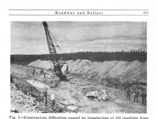
As the alinement passes beyond the influence of the river valleys, the predominant soil formation becomes a sandy glacial till. Grain-size distrlbution curves for samples of t h i s m a t e r i a l f r o m t h e A s h u a n i p i L a k e a r e a ( M . P . 2 0 1 a n d M P . 2 2 1 ) a r e s h o w n i n Fig. 4. A well-graded sandy soil, the till has proved to be a good embankment material. Because of the low in-place density and high moisture content, however, these soils were often difEcult to place during grading operations. Fig. 5 shows a cut section at M.P. 201 and illustrates the type of problem encountered. North of M.P. 270, soils were generally better drained and caused little diffrculty.
In the vicinity of Menihek Dam at M.P. 330, the coarse-textured and generally well-graded glacial till provided the 650,000 cu yd of material required for the rolled, homogeneous earth-fill sections of the dam (7). The fill was placed in 6- to 8-in lifts, using both trucks and rubber-tired tractor-scrapers and compacted by tractor-drawn sheepsfoot rollers. A sand and gravel underfilter beneath the downstream slope was incorporated in the fill by excavating and backfilling. Upstream sides were constructed with submerged slopes of 3:1 and upper slopes of 2:1. These slopes were provided with a coarse gravel blanket and toe, and the upper sections protected by rip-rap stone quarried locally. Downstream slopes of 2.5 : 1 were provided with a toe of riverbed boulders or coarse gravel and protected by a gravel facing. Suitable gravel for this
R o a d w a y a n d B a l l a s t
Fig. 5.-Construction difficulties caused by liquefaction of till resulting from
a c t i o n o f construction m a c h i n e r y , M i l - e 2 0 1 ( P h o t o : G . D . C r e e l m i n ) .
purpose was not readily obtained in the Menihek area and was hauled from the ballast pit at M.P. 29O af.ter construction.
Construction of the rolled filI sections of the dam was begun in May and com-pleted in October 1953, a summer of unusually light precipitation, and was not seriously affected by adverse moisture conditions.
In the Labrador Trough region, gravelly soils with a high percenlage of clay-size particles have proved to be susceptible to frost, and in a few locations heavy differen-tial heaving in the winter months has b'een followed by the appearance of mud boils as late as July. As the grain-size distribution curves show, some of the till o,f the Ashuanipi Lake area is a borderline soil using Beskow's criterion for frost-susceptible morainic soils (8). Some frost heaving has occuned in this material.
6. Granular Deposits From Eskers and Outwashes
A fortunate circumstance from an engineering aspect is the existence on the
Labrador Plateau of extensive deposits of coarse-textured granular material in the form of eskers and other granular landforms. Several large borrow pits were established at the close of the track laying phase to provide the fill with which embankments were widened and brought to grade, using train-haul methods. Suitable deposits in the form of eskers were located for this purpose at M.P. f34, M.P. 223 and M.P. 29O. At M.p. 84, near the head of the Wacouno River valley, a well-graded outwash formation pro-vided another source o,f excellent material. The better and more favorably located of these pits (M.P. 84 and M.P. 290) continue to supply crushed and scr,eened railwav ballast and coarse aggregate for concrete.
Transportation requirements during the construction period made the location of
6 7 8 R o a d w a a n d B a l l a s t
airstrips, suitable for use in all seasons, an important consideration. The 5000-ft run-ways constructed at M.P. 134, M.P. 224 and. M.P. 290 are examples of the excellent use which may be made of glacial deposits from eskers. In connection with the constr,uction of airstrips, it is fortunate that the north-south trend of most granular landforms coincides with the direction of the prevailing northwest winds.
7. Lacustrine Silts and Sands
Between M.P. 180 and M.P. 280, the alinement follows closely the shorelines of Ashuanipi, Whitman, Molson, and Menihek Lakes and passes through many areas with poor internal and surface drainage. Here the soil profile frequently shows tha't deposits of lacustrine silts and sands overlie the till with a surficial cover of musk€g. As a r'esult of the high water table, cuts in this material invariably produced "near-quick" conditions. The silts were generally excluded from the roadbed and have proved to be troublesome in the more or less local situations where they w€re placed in fills. During the construction period, ,every effort was made to use completed or partially completed sections of the railway subgrade as a haulage road, and encounters with these fine-textured materials were the cause o,f much distress.
Between M.P. 95 and M.P. 120, in the wide basin now occupied by the relatively narrow Wacouno Lake, many shallow cuts wer€ necessary in silty fine sand and also in much coarser but poorly graded soils with a large proportion of fines. These soils were fairly \4/ell drained and presented little difEculty during construction, but are highly susceptible to frost and have performed badly in this repect.
8. Muskeg
The combination of imperfect drainage, bigh precipitation, and a cold climate has resulted in the development, on the Labrador Plateau, of an almost continuous cover oI shallow muskeg or partially decayed fibrous organic matter. Along the route of the railway, the most extensive areas of muskeg are located in the drainage basins of the Iarger lakes and at the headwaters of such streams as the Wacouno and Embarrassee Rivers. The depth of this organic cover seldom exceeds 3 or 4 ft and although deeper deposits do exist, they were avoided whenever possible. The material consolidated rapidly a.fter the placing of fills and differential settlement has been unimportant. The most serious diffrculties occurred during construction when wide detours were often necessary in order to carry the all-important haulage road past incomplete sections of the railway subgrade.
G. CONSTRUCTION AND MAINTENANCE PROBLEMS
l . S l i d e s i n B a n d e d Clays
Slope stability in sections of the stratified silts and clays is being studied exten-sively. The landslide problem became apparent in the spring of 1951 wben, during construction of the tunnel at M.P. 12, the rock roof collapsed about 200 ft from the south portal allowing the overlying silty clay to cave in. The resulting disturbance caused the material to liquefy (the liquidity index of the clay in this locality has been found to be close to 2) and some 60,000 cu yd of clay poured through the tunnel roo{ and flowed through the south portal before equilibrium was restored. To prevent tbe occurrence of further mud flows during reconstruction of the tunnel roof and to facilitate this operation, an additional 4o,ooo cu yd was excavated hydraulically.
R o a d w a y a n d B a l l a s t 679
F i g . 6 - S l i d e i n t h e s i l t y clay bank at Mile 12 (Photo: G. D. Creelman).
A second earth movement involving 3000 cy yd of silty clay took place at the same tunnel in September f953. On this occasion, the failure took the form of a cir-cular slip in the cut slope at the approach to the south portal. The original slope had a vertical height of 70 ft and was excavated at 1.5:1. Fig.6 shows the failure shortly after the right-of-way had been cleared.
As a remedial measure, about 7000 cu yd o,f soil were excavated from the shoulder of the slope to form a bench 30 ft in width and 50 ft above the shoulder. Despite the resulting reduction in driving moment, a f urther failure involving the material below the bench occurred in the spring of 1954.
Using the actual slip circles and shear strength values derived from unconfined
compression and vane tests, d:0 stability analyses indicated theoretical factors of
safety of about 2.0 in the case of both slope failures. Borings undertaken in 1956 disclosed the presence of a continuous sand stratum between the banded sediments and the underlying bedrock surface which outcrops a f,ew hundred feet from the shoulder of the cut slope. Three days prior to the first slide, 3.79 in of rain were recorded during a 24-hr period, while the second slide occurred at a tirne when melting snow caused the groundwater table to be at its highest. It seems probabl€, therefore, that the development of high hydrostatic pressures within the confined sand stratum may have contributed to the failures.
During the spring of 1955, a third failure was anticipated, and an unstable sectjon of the slope was induced to fail by blasting. Removal of the debris and excavation of a drainage ditch at the toe of the slope exposed the buried sand stratum, and no additional fai'lures have occurred to date.
680 R o a d w a y a n d B a l l a s t
Construction of the roadbed through the banded clay soils of the Moisie valley frequently required the excavation of benches in the natural riverbank slopes. In these sections, failures may involve an entire slope or may be confined either to the cut slope above track lwel or to the embankment slope beneath the roadbed. To date, no failure has involved an entire slope of this type, but there have been some slides in both cut and embankment sections. On April 25, 1955, a failure of the latter type occurred at M.P. 19.5. The track structure at this location was supported by a gtanular fill founded largely on the riverbank slope and deriving little support from a narrow bench cut into the side of the original slope, just below track elevation. Failure of the clay slope below the bench caused 15,000 cu yd of fill to slide into the Moisie River on a 150-ft front, leaving the track suspended.
It has been mentioned previously that stratified sands and gravels overlie the banded clays and occupy local depressions in the surface of these deposits. An example of the latter condition exists at M.P. 18.6 where a 60-ft side hill cut was made in an apparently extensive deposit of banded silty clay, overlain by a shallow cover of gravel and sand. Four years after completion of the cut, borings disclosed that at one point the granular cover close to the shoulder was actually 9O ft in depth, with the ground-water table close to the surface. Extensive drainage m'easures were required to lower the water table in this pocket of saturated sand.
A number of factors may thus be said to contribute to the landslide problem and make theoretical stability analyses extremely difficult to apply to design. Such factors include the following:
a. The banded silty clays have high liquidity indices and become unstable with vibration or other disturbance. There is always a danger that a minor slope failure may develop retrogressively into a "mud flow" of some proportions.
b. Non-uniformity of the formations, variations in thickness and character of the
bands, the presenc€ of sandy strata and the inclination o'f bedding planes. c. Because of high relief of the valley walls in the Iocations where these
mate-rials occur, there are many sections where high hydrostatic pressures can
develop. With a high water table in the granular overburden, heavy summer rainfall (the month of July averages 4.5 tn) and a rapid run-off, drainage at the shoulders of the slopes is critical in order to prevent erosion and the development of seepage pressures.
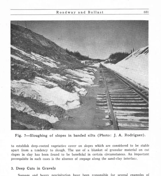
2 . S l o u g h i n g o f Slopes
This problem is the most serious marifestation of the effect of frost in the section south of M.P. 28. As indicated by Fig. 7, the silty clay is particularly troublesome in this respect. Despite the fact that wind tends to prevent the accumulation of snow on cut slopes, frost penetration is restricted to 18 or 24 in by the high moisture content of the clay. Conditions are conducive, however, to the formation of ice lenses. These form ideal sliding surfaces for the overlying material which begins to slough into side ditches with the first periods of warm sunshine in the spfing. Ditches are thus fre-quently obstructed even before the snow has begun to melt, and the problem usually persists until June, requiring a considerable amount of maintenance.
Cut slopes exposed to several winters tend to become more stable from the standpoint of sloughing as a weathered surface layer some 2 ft thick develops. This weathered crust does not support the growth of ice lenses to the same extent as the parent material and is more tolerant of vegetation. Efforts are therefore being made
R o a d w a y a n d B a l l a s t
F i g . 7 - S l o u g h i n g o f s l o p e s i n b a n d e d s i l t s ( P h o t o : J . A . R o d r i g u e z ) '
to establish deep-rooted vegetativ€ cover on slopes which are considered to be stable apart from a tendency to slough. The use of a blanket of granular material on cul slopes in clay has been found to be beneficial in certain circumstances. An important prerequisite in such cases is the absence of seepage along the sand-clay interface.
3. Deep Cuts in Gravels
Seepage and heavy precipitation have been responsible for several examples of sloughing in sands and gravels. At M.P. 32.8 in June 1955, a movement which ap-proached the proportions of a slide occurred in sand overlying a steep buried rock slope and was apparently triggered by the passage of an ore train. The vertlcal height of the slope was 22O ft, with the crest of the buried rock slope some 40 ft below the shoulder. Seepage from a small pond located about 800 ft from the shoulder of the slope is believed to have contributed to the slide in which 2000 cu yd of waterlogged sand sloughed from the upper part of the slope, derailed a train, and buried the track to a depth of 15 ft. A rainstorm (0.26 in) 11 days prior to the slide resulted in several minor slides in the lower part oI the slope, a factor which may have affected the over-all stability of the slope.
Fig. 8 is drawn from an'aerial photograph of the location and illusttates the posi-tion of the pond ldith respect to the failure of the slope. Through the use of airphotos and ground surveys, all potentially dangerous slopes are being investigated and, where necessary, measures are being taken to drain perched lakes.
P E
R C H E P O N D S
H I L L C U T I N S A N O
L A N D S L I D E
- . J U N E
l$ re
I{rd
P R E C A M B R I A N
O U T C R O P S
V E R Y R O U G H
Fig. 8-Location of landslide at Mile 32.5 (traced from RCAF airphoto
No. A14460-19). Inset: aerial view of cut at Mile 32.5 (Photo: B. M.
Mqnaghan and J. A. Rodriguez).
o
R o a d w a y a n d B a l l a s t 6 8 3
Fig. 9-Condition of grade during construction in silty area ( P h o t o : G . D . C r e e l m a n ) .
4. Muskeg
The initial procedure followed in construction through muskeg sections called for the use of light draglines supported on timber rafts or mats, and was facllitated by the generally shallow depth of the organic cover. These machines, working in pairs one on each side of the proposed roadbed, excavated side ditches by wasting the organic material and silt, and casting enough of the underlying till onto centerline to form a trafficable road. The subgrade was laLer completed using carry-alls or trucks hauling from available borrow pits. since much of the granular glacial till was of a silty character, this procedure made it inevitable that in some instances silty material was incorporated in the roadbed in a wet, loose condition. Because of the low relief, ditches were not always effective in removing water and, under these circumstances, equipment was frequently mir'ed in the grade. Fig. 9 indicates the unstable conditions rvhich developed on occasion, especially during wet weather.
Shallow cuts encountered in the muskeg area oflen proved troublesome; even glacial till having a tendency to liquefy when exposed to traffic, as Fig. 5 illustrates. The results of Proctor density tests conducted on samples taken from stable and unstable sections of the same fill at M.P. 267 are shown in Fig. 10. since the grading of the samples was substantially the same (Fig.4), the cause of the instability was clearly lack of adequate compaction and excess moisture content. In very wet locations, relief from the effect of the high watertable was obtalned by using dynamite to blast offtake ditches before construction began.
Since haulage roads between construction camps necessarily made wide detours around muskeg sections, access to working points was a major difnculty. Advantage
R o a d w a y a n d B a l l a s t t z b F
\ rz+
f, o u t q o uo-3 v o
z o L i l q F . . . _ | o (J|z
ul 6 i l 4 0(a l r 2
l l (oP T lM Utt V A T E R C O N T E N T E X C E S S V A T E R U N 9 T A 9 L E F I L L(NoRTH
sectrox) rr
l-,
l-t u)-
-t{
\
q as
oX
lti
X
ts 6 T A C L E F I L L( s o u r H s e c l r o x )
7$li
;|.!
I
I
- vArER OLFICiL|1CY, G 7 6 9 t o t t t 2 t 3 t 4 l r t ( t
v A T E R c o x T e - x 1 / "Fis. - l0-Curves showine the relationship between dry density and water content as found-by the Standard Proctor Compaction Test'
was taken of f rozen ground at the end o,f the winter season to locate machines strategically in readiness for the spring. In the case of t}re more isolated locations, it was necessary to use canoes and boats in order to service machines and transport personnel. 5. Concrete Aggregates and Ballast Materials
The organic contamination of sands and gravels is general throughout the r'egion. In the case of minor concrete structures, it was usually possible to locate acceptable gravel deposits for concrete aggregate within a reasonable distance of construclion sites, but long hauls were occasionally required.
Pit-run material from the stratified sands and gravels of the lower Moisie and Nipissis valleys provided suitable graded aggregates for the construction of bridges at M.P. 30 and M.P. 40. The same deposits also supplied much of the aggregate required for construction in the terminal area of Sept Iles, although a quantity of good quality aggregate was imported by boat. For major structures, such as the Ste. Marguerlte Dam, 20 miles west of Sept Iles, and the Moisie River bridge at M.P. 12, Iocal gravel deposits supplied ttre fine aggregate, while coarse aggregat€ was prepared by crushing and screening rock quarried locally.
The gravels associated with the glaciated river valleys and the granular land-forms of the Labrador Plateau are derived from many types of rock. In general, the presence of granite gneiss characterizes the gravels of the Upper Wacouno River valley, wh'ile metamorphic schists with quartzite as the predominant material are characteristic of the Labrador Plateau. When crushed and screened, the gravel from these sources is suitable for both railway ballast and concrete aggregate.
The rocks of the Labrador Trough atea &re trsually dense, fine-grained and have a l l o
R o a d w a y a n d B a l l a s t o 6 5
tendency to break into harsh angular fragments with flat elongated shapes. The crushed product has a high abrasion resistance and despite its highly fissile nature is acceptable as railway ballast. Owing to the presence of such undesirable constituents as chert, phyllite and iron pyrites, however, the rocks are generally unSuitabl€ for use as con-crete aggregate. This situation, and the absence of clean gravels, necessitated the use of a highly contaminated deposit of stony glacial drirft as the source of concrete aggregate for the Menihek Dam at M.P.330 (7). This deposit comprised stones derived from the local bedrock, together with quartzitic cobbles and boulders. Washing and screening removed most of the organic contamination along with the fines. Subsequent crushing and sand-roll operations reduced the large quartzitic cobbles to a maximum size ol 2 in and improved the grading by restoring tbe proportion of sand-size particles.
H. FROST ACTION AND ROADBED MAINTENANCE
1. Ground Temperatures
The region traversed by the railway is noted for heavy precipitation and severe wintersl tle effect of frost action on the performance of the roadbed is thus a major consideration. At the outset, the problem was confounded by a lack of informatlon on the depth of seasonal frost penetration and meager data on air temperatures. To sur-mount this difficulty, a program of ground temperature measurements was started to study the thermal regime in typical soils under various conditions of exposure and surface cover. Three field installations were made-at SchefferVille, at M.P. 266, and, at S e p t I I e s ( 9 ) .
The study of frost penetration along the railway route is being coordinated with the broader study of climatic data and soil temperatures which is being conducted by the Division of Building Research of the National Research Council (i0).
2. Maintenance
Problems altributable to frost action include the following: (a) differential heaving of track and softening of the roadbed on thawing, (b) sloughing of cut and embank-ment slopes, (c) icing of track and culverts due to side-hill seepage.
a. Frost Heaadng ol Track
Improved drainage and the use of admixtures such as sodium chloride, calcium chloride and calcium lignosulphonate are two of the measures adopted to surmount the problem. All three admixtures have been effective in reducing the amount of heave, but their relative value is difficult to assess stnce track-raising and drainage improve-ments have also contributed. Complete excavation of frost-susceptible soils and replace-ment with granular materials has been undertaken in some locations.
b. Sloughing of Slo?es
This aspect of frost damage has been discussed in connectlon with the banded clays of the Moisie valley where the problem is particularly severe. fn the muskeg sec-tions of the Labrador Plateau some sloughing of low embankment slopes into side ditches occurs during the spring run-off period as the frost leaves the ground. This condition has been relieved by widening embankments with coarse granular material.
c. Icitug
The icing problem has been mentioned in connection with rock cut sections of tbe railway, but it also occurs in sidehill cuts elsewhere. The difficulties caused bv this
686 R o a d w a y a n d B a l l a s t
condition have been eased by the diversion of surface water and measures designed to prevent culverts from becoming obstructed.
3 . P e r m a f r o s t
During construction operations in 1953, two locations where frozen soil was encoun-tered in September suggested that permafrost was a definite possibility in Labrador. At M.P. 245, a shallow cut revealed frozen ground with ice lenses 3 in thlck extending to a depth of ol ft. It was very unlikely that this frost would leave the ground before the onset of the next freezing season. At tlis location, a winter haul road crossed the grade line and might have fostered a deeper than normal seasonal frost penetration. At M.P. 253 fuozen soil was again encountered, in this case at a locatlQn where there was no haul road. These occurrences of frozen soil strongly suggest that scattered islands of permafrost do occur. Further, if the frozen ground at M.P.245 did result from the winter haul road, then the possibility exists that grading operations may cause permafrost to develop under certain conditions.
4. Ballasting
One beneficial effect of extreme low temperatures may be cited in connection with the distribution of ballast. Completion of the track laying program in February 1954 made it necessary to stabilize the skeleton track by the distribution of coarse gravel ballast during the winter months. It was found ttrat relatively dry gravel could be hauled any required distance and dumped, if it was allowed to f.reeze before loading and if the air temperature did not rise above approximately 15 deg F. At higher tem-peratures the material ceased to be free-running and tended to agglomerate in the cars.
I. CONCLUSIONS
Although long recognized as being potentially of great economic importance, the Labrador Peninsula remained a relativ€ly inaccessible region until comparatively recent years. The airplane (and more particularly the floatplane) has done much to alter this situation, and aerial photography has provided an excellent engineering tool to aid in the development of the region.
Photogrammetry has facilitated mapping while the use of aerial photographs in connection with route surveys, drainage schemes, and site location will continue to play an important role in the plannlng and execution of engineering projects. Apart from the value of aerial photographs in simplifying location and survey work, airphoto interpretation can provide much information on unconsolidated deposits and soll con-ditions. This is information that can be procured only with difficulty using conventional methods.
Most of the difficulties encountered during and subsequent to construction of the Quebec North Shore & Labrador Railway have been of a regional nature, and similar problems, with local variations, are likely to occur throughout a large section of the Labrador Peninsula. Because of the close relationship between topography and the character of glacial deposits, one of the most satisfactory ways to approach these problems is through an appreciatlon of the glacial and post-glacial history of the region. In general, the most serious construction problems are related to the excavation and placing of wet soils. The loose, wet condition in which many soil deposits occur accounts for the diffrculty experienced even with granular tlll-normally considered to give satisfactory performance'
R o a d w a y a n d B a l l a s t 0 6 /
Maintenance problems arise from two principal causes: the effects of frost action and the instability of slopes. In a climate with high precipitation and very low winter temperatures, the effects of frost action become a major deslgn consideration and one which should be recognized in the early stages of planning. Much can be done with respect to identification and mapping of frost-susceptible soils before a final location is established. At a later stage, the proper design of earthworks can do much to minimize effects of frost action such as heaving, icing and the sloughing of slopes. In the central section of the Labrador Peninsula, the effect of permafrost becomes an equally important consideration.
The stabllity of slopes in banded clays is a persistent problem in the southern section of the region. Since the slopes or river banks and terraces tend to be unstable in their natural state, every effort should be made to avoid construction in these locations. When relocation is impracticable, construction operations should be so directed that nothing is done to decrease the stability of natural slopes. Maintenance practices in these unstable sections should be preventive as well as remedlal, and should be based upon the regular inspection of slopes and drainage facilities. Accumulation of records o'f the physical properties of clay soils and detailed investigation of failures are of inestimable value in planning a rational approach to the problem of maintenance.
J. ACKNOWLEDGMENTS
This paper is a joint contribution from the School of Civil Engineering, Purdue University, the Quebec North Shore & Labr.ador Railway Company, and the Division of Building Research, National Research Council, Canada. In preparing the paper, the authors received encouragement and advice from their colleagues in each organization. Particular acknowledgment is due to B. M. Monaghan, chief engineer, Quebec North Shore & Labrador Railway, with whose permission this paper is published, and to R. F. Legget, Division of Building Research, National Research Council, who approved of the contribution from the Division.
K. BIBLIOGRAPHY
(1) Livingston, D. A. "Reconnaissance of the Labrador Railway,1945". Engineering J o u r n a l , V o l . 3 7 , N o . 4 , p p . 3 9 9 - 4 0 5 , ( 1 9 5 4 ) .
(2) Monaghan, B. M. "The Location and Constructibn of the Quebec North Shore a n d L a b r a d o r Railway". Engineering Journal, Vol.37, No.7, pp. 820-828, (1954). (3) Thomas, M. K. "Climatological Atlas of Canada". Canada, Department of
Trans-port and National Research Council. NRC No. 3151. December 1953.
(4) Canada, Department of Mines and Resources. "Geology and Economic Minerals of Canada", Bureau of Geology and Topography, Mines and Geology Branch, Department of Mines and Resources, Ottawa, Canada. ,1947).
(5) Gadd, N. R. "Geological Aspects of Eastern Canadian Flow Slides,'. National Re-search Council, Canada. 1z Proceedings of lOth Canadian Soil Mechanics Con-ference, Associate Committee on Soil and Sndw Mechanics, Technical Memoran-dum No. 46, Ottawa, 1957.
(6) Pryer, R. W., and K. B. Woods. "Investigation of B,anded Sediments along St.
Lawrence-North Shore in Quebec". Paper presented to 6lst Annual Meeting of
ASTM, Boston, June 1958.
( 7 ) Carey, L. A. "Menihek Power Development". Engineering Journal, Vol.37, No.5, p p . 5ae-5ff, (r95a).
688 R o a d w a y a n d B a l l a s t
(8) Beskow, G. "Soil Freezing and Frost Heaving with Special Application to Roads and Railroads" (1935). Translated bv J. O. Osterberg, Technological InStitute, Northwestern University, (1947).
(9) Pryer, R. W. "Frost Action and Railroad Maintenance in the Labrador Peninsula". Paper presented to 37th Annual Meeting, Ifighway Research Board, Washington, January 1958.
(10) Crawford, C. B. "Frost Penetration Studies in Canada as an Aid to Constructioni', Roads and Engineering Construction, Vol. 93, No. 2, February 1955' p. 71. (11) Douglas, M. C. V., and R. N. Drummond. "Map of Physiographic Regions of