HAL Id: hal-00299398
https://hal.archives-ouvertes.fr/hal-00299398
Submitted on 10 Jan 2007
HAL is a multi-disciplinary open access
archive for the deposit and dissemination of
sci-entific research documents, whether they are
pub-lished or not. The documents may come from
teaching and research institutions in France or
abroad, or from public or private research centers.
L’archive ouverte pluridisciplinaire HAL, est
destinée au dépôt et à la diffusion de documents
scientifiques de niveau recherche, publiés ou non,
émanant des établissements d’enseignement et de
recherche français ou étrangers, des laboratoires
publics ou privés.
Investigation on tsunami effects in the central Adriatic
Sea during the last century ? a contribution
A. Maramai, L. Graziani, S. Tinti
To cite this version:
A. Maramai, L. Graziani, S. Tinti. Investigation on tsunami effects in the central Adriatic Sea during
the last century ? a contribution. Natural Hazards and Earth System Science, Copernicus Publications
on behalf of the European Geosciences Union, 2007, 7 (1), pp.15-19. �hal-00299398�
www.nat-hazards-earth-syst-sci.net/7/15/2007/ © Author(s) 2007. This work is licensed under a Creative Commons License.
and Earth
System Sciences
Investigation on tsunami effects in the central Adriatic Sea during
the last century – a contribution
A. Maramai1, L. Graziani1, and S. Tinti2
1Istituto Nazionale di Geofisica e Vulcanologia, Sezione Roma 2, Rome, Italy 2University of Bologna, Dipartimento di Fisica, Settore Geofisica, Bologna, Italy
Received: 28 September 2006 – Revised: 13 December 2006 – Accepted: 13 December 2006 – Published: 10 January 2007
Abstract. In this work we present the result of a study aimed
at examining the Italian earthquake sequences that occurred in the area of the central Adriatic sea with the purpose of understanding whether some of them were accompanied by tsunami effects. The motivation for this research was the up-date and enrichment of the Italian Tsunami Catalogue. The result was that evidence was found for two new cases of earthquake-induced tsunamis: these are the August 1916 Ri-mini and the October 1930 Ancona events.
The bulk of the present research consisted in collecting all the available data on the earthquakes that affected the se-lected area in the past century and in identifying those po-tentially capable of generating tsunamis. During the study all the available material was gathered, which includes spe-cific monographs and scientific papers, articles available in contemporary chronicles and in local and national newspa-pers. The final result of this research will improve our knowl-edge of the tsunamigenic activity of the central Adriatic sea and contribute to the assessment of the tsunami hazard and risk along these coasts, that especially in the peak season form one of the most densely populated areas of the Italian peninsula with flat and large beaches and water front resorts crowded of tourists.
1 Introduction
In the frame of the geophysical knowledge of the Mediter-ranean region the geodynamic evolution of the Adriatic mi-croplate, very complex and still debated, plays a key role. Many international studies have been carried out with the aim of better assessing the seismicity of this region (Bada et al., 1996; Babbucci et al., 2004; Battaglia et al., 2004; Venisti et al., 2005; Pinter and Grenerczy, 2006; Altiner et al., 2006;
Correspondence to: A. Maramai
(maramai@ingv.it)
Thouvenot and Fr´echet, 2006; Muc¸o, 2006). They put in evi-dence that the Adriatic sea presents a quite low seismic activ-ity, mainly with intraplate earthquakes characterised by mod-erate magnitudes. Earthquakes catalogues show large uncer-tainties in the hypocentre locations and in the magnitude es-timates: the historical seismicity is poorly documented and, in particular, one of the major difficulties is to establish if an earthquake occurred in the Adriatic sea or inland. Similarly, instrumental seismicity shows mislocations probably due to badly spaced recording stations. In the last decades, signif-icant seismicity has been noticed in this area, with impor-tant seismic sequences having main shocks of relevant mag-nitude.
The most recent Italian Tsunami Catalogue (Tinti et al., 2004), spanning from 79 AD to 2004, contains a number of tsunamis observed along the Adriatic coasts which can be put in relation to the earthquake activity. In the catalogue each event is characterised by a “reliability” value, a very important parameter which expresses the quality of the data, and by a tsunami “intensity” value. The reliability is graded according to the 5-degree modified Iida scale (Iida, 1956) and ranges from degree 0, equivalent to a “very improbable tsunami”, to degree 4 corresponding to a “definite tsunami”. The tsunami intensity value is attributed on the basis of the effects of a tsunami on structures and environment and it is based on the Sieberg-Ambraseys scale (Ambraseys, 1962).
The total number of tsunami events reported in the Ital-ian Tsunami Catalogue for the central Adriatic region is 8 (Fig. 1), most of them of low intensity (intensity 2 “light” on the Ambraseys-Sieberg scale) and one reaching intensity 5 (“very strong”) that is the 30 July 1627 Gargano event. The catalogue divided the Adriatic region into four subregions, namely North Adriatic, in which one tsunami occurred, cen-tral Adriatic, with 3 events and Gargano and Apulia, both af-fected by 2 tsunamis. All of them, except one, are of seismic origin.
16 A. Maramai et al.: Tsunami effects in central Adriatic
I T
A L
Y
A D R I A T I C S E A NORTH ADRIATIC CENTRAL ADRIATIC GARGANO APULIA 1627 10.600 E 40.300 N 19.800 E 46.000 N NFig. 1. Geographic distribution of tsunamis in the Adriatic Sea
(af-ter the Italian tsunami catalogue, Tinti et al., 2004). Stars repre-sent tsunami sources. Note that the 1978 tsunami source north of Gargano is still uncertain and is taken here from Bedosti (1980). The four subregions are shown.
In this work we focus on the central Adriatic subregion, in order to perform a deep investigation of the area, also fi-nalised to update the Italian Tsunami Catalogue. The most relevant earthquakes that occurred in the last century have been analysed, with the aim of establishing whether they could have been accompanied by tsunamis. To accomplish this goal, we gathered all suitable documents available in contemporary chronicles, in local and national newspapers as well as in specific monographs and scientific articles.
2 Italian Tsunami Catalogue: tsunami events in central Adriatic
As mentioned before, the Italian Tsunami Catalogue (Tinti et al., 2004) reports that the central Adriatic subregion expe-rienced three tsunami events, two of them of seismic origin and the third one of uncertain cause, probably due to a sub-marine landslide. Here a short description of the events is given.
The first tsunami of the area occurred on 14 April 1672 when a strong earthquake caused severe damage and many fatalities (some sources report 200, some others more than 500). The earthquake, with equivalent magnitude Me=5.7 (Me is deduced from macroseismic data. For the definition of Me, refer to CFTI, 2004) and I=VIII Mercalli Cancani Sieberg (MCS) scale, was located in land a few kilometres far from Rimini (Fig. 2). According to the coeval descriptions, at Rimini the sea withdrew and then flooded the coast by about 20 paces (15 m) and some fishermen, that were in the sea close to the Rimini coast, observed an unusual strong sea
ADRIATIC
SEA
Cesenatico Cervia Rimini Pesaro Ancona 1672 1875 15.100 E 44.900 N N 10.700 E 43.100 NFig. 2. Localities affected by the 1672 and 1875 Adriatic tsunamis.
Stars represent the epicentres of the two tsunamigenic earthquakes.
agitation (Boschi et al., 1997; Tinti et al., 2004). The tsunami intensity attributed in the catalogue is 2.
On 17 March 1875 another tsunami hit the central Adri-atic area after a strong earthquake (Me=5.8 (CFTI, 2004), I=VIII MCS scale) with epicenter in the sea close to Rimini, involving central Italy and part of northern Italy. The shock was very violent at Cesenatico, Rimini and Cervia (Fig. 2), where many chimneys ruined and some houses suffered dam-age. At Rimini some fishermen in boats felt a violent hori-zontal shock and noted some big waves. In the harbour the sea level was at a high tide, passed suddenly to a low tide returning to high tide again 2 min later. At Cervia the sea violently flooded quite a large part of the beach and some sailors felt the shock on the boats. At Cesenatico some big waves flooded the beach. At Pesaro eye-witnesses on the beach were reached by two big waves up to the waistband. At Ancona eye-witness report of some big waves (Tinti et al., 2004). The intensity attributed to this event by the Italian catalogue is 3 (“rather strong”).
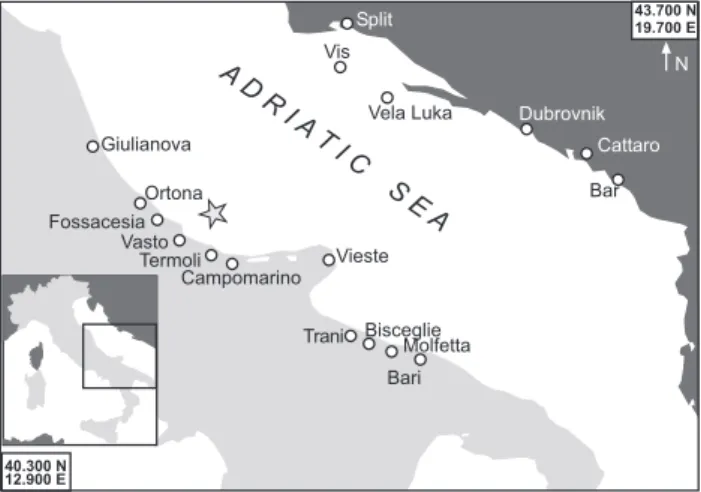
A third tsunami event occurred on 21 June 1978: anoma-lous coastal oscillations of the sea, with a period of about 10–15 min, were observed along a 300 km stretch of coasts in the central Adriatic, between Giulianova and Bari (Fig. 3). No earthquake was recorded in that day to justify the anoma-lous event. Bedosti (1980) hypothesises that a possible cause was a submarine landslide beneath the 200 m isobath more or less between Termoli and Vasto (see star in Fig. 3). We remark that in the Italian Tsunami Catalogue this event was attributed an unknown cause, and we still persist in this po-sition since new investigation is needed to unveil the real cause. We remark, however, that if the tsunami was induced by a submarine landslide, the source can very unlikely be lo-cated in the place suggested by Bedosti (1980) so close to the coast. Recent investigations show that this area is not suscep-tible to large offshore mass failures (Trincardi et al., 2004), while evidence for widespread failures has been found in the south-western Adriatic margin (Minisini et al., 2006) more than 100 km offshore south of Gargano, where steep slopes link the shallow Adriatic platform to the deep Ionian sea.
A D R I A T I C S E A Giulianova Vasto Termoli Ortona Fossacesia Vieste Trani Molfetta Bari Bisceglie Dubrovnik Split Vis Vela Luka Bar Campomarino Cattaro 12.900 E 40.300 N 19.700 E 43.700 N N
Fig. 3. Localities where tsunami effects were observed during the
1978 Adriatic event. The star represents the position of the subma-rine landslide hypothesised by Bedosti (1980), which is still under debate.
At Giulianova the sea withdrew by about 50 m and it came back 6 min later surpassing the normal level by about 60 cm. Oscillations repeated many times with period of 15 min and amplitude of 60 cm in the harbour. At Ortona only one oscil-lation was observed, with a withdrawal of 15 m. At Bisceglie the sea withdrew by 2–3 m and then flooded the beach by 200 m. The maximum height was 50 cm. Two fishing boats broke their mooring. At Molfetta a 10 m withdrawal was no-ticed. The period was 5 min. Anomalous oscillations also were observed at Fossacesia, Vasto, Termoli, Campomarino and Trani at different times.
Anomalous disturbances were also seen on the east-ern coast of the Adriatic Sea: at Bar (30 cm), Dubrovnik (40 cm) and Split (45 cm) (Zoe-Armanda, 1988; Papadopou-los, 1993).
Some newspapers report detailed description of the phe-nomenon, as follows. At Termoli the sea withdrew by tens of metres leaving the harbour dried and then violently came back; some swimmers referred that the sea water suddenly became cold and immediately after became also turbolent and strongly agitated (Il Messaggero, 1978) At Bari the sea water suddenly withdrew many times leaving the seafloor dried; some moored ships in the harbour went aground and some fish was found on the beach. At Bari and Vieste the sea suddenly withdrew by about 50–100 m leaving boats aground and after a few minutes the sea violently inundated the shore with very high waves, causing damage to the boats and some injured people. The sea water swept away the beach-umbrellas (Il Messaggero, 1978; Il Corriere Adriatico, 1978).
In many islands and places along the Yugoslavian coasts the sea water suddenly rose; at Vela Luka (Korcula island) the waves were 8 m high, inundating the first floors of all the buildings on the shore. Many ships suffered severe damage
CENTRAL ADRIATIC 42.300 N 44.300 N 1930 1916
Fig. 4. Geographic distribution of the studied earthquakes in the
central Adriatic subregion.
and the sea water flooded the cost by 650 m inland. Also at Cattaro (Montenegro), as well as at Dubrovnik and at the Vis island, anomalous waves were observed.
We notice further that, in spite of the fact that the event took place in modern instrumental era and affected a vast area, and that the Adriatic tides were monitored by a number of tide-gauge stations at the time, we were not able to find any instrumental records of this tsunami.
3 Further tsunami events in central Adriatic
In order to have a more complete picture of the tsunamigenic potential of the studied area, we performed accurate investi-gations on the earthquakes that occurred in the last century with the aim of identifying those potentially capable of gen-erating tsunamis, also minor, that are not included in the Ital-ian Tsunami Catalogue. To this purpose, all the available material was gathered, with a scrupulous and careful search for the sources, including specific monographs and scientific papers, articles available in contemporary chronicles and in national and local newspapers.
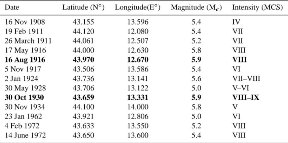
The first step of the analysis consisted in examining re-cent Italian seismic catalogues (Boschi et al., 1995, 1997; CPTI2, 2004) and selecting the most relevant earthquakes, with magnitude M≥5.0, in the geographical area included between latitude 42.300 N to 44.300 N. We examined events occurred since 1900, with epicentre located in the sea or in land near the coast, namely not more than 25 km far from the shore. Thirteen significant earthquakes have been identified (Table 1 and Fig. 4.), and only for two of them tsunami ev-idences have been found, respectively the 16 August 1916 and the 1930 events.
The tsunami events have been examined by using the same evaluation parameters adopted during the Italian Tsunami
18 A. Maramai et al.: Tsunami effects in central Adriatic
Table 1. List of the studied earthquakes taken from the Italian catalogue CPTI2 (2004). In bold the two events for which tsunami evidences
were found. For a definition of Mesee CPTI2 (2004).
Date Latitude (N◦) Longitude(E◦) Magnitude (M
e) Intensity (MCS) 16 Nov 1908 43.155 13.596 5.4 IV 19 Feb 1911 44.120 12.080 5.4 VII 26 March 1911 44.061 12.507 5.2 VII 17 May 1916 44.000 12.630 5.8 VIII 16 Aug 1916 43.970 12.670 5.9 VIII 5 Nov 1917 43.506 13.586 5.4 VI 2 Jan 1924 43.736 13.141 5.6 VII–VIII 30 May 1928 43.706 13.122 5.0 V–VI 30 Oct 1930 43.659 13.331 5.9 VIII–IX 30 Nov 1934 44.100 14.000 5.8 V 23 Jan 1962 43.921 12.806 5.0 VI 4 Feb 1972 43.633 13.550 5.2 VIII 14 June 1972 43.650 13.600 5.4 VIII
ADRIATIC
SEA
Ancona 15.100 E 44.900 N N 10.700 E 43.100 N Rimini Pesaro Senigallia Riccione 1916 1930Fig. 5. Localities affected by the 1916 and 1930 tsunamis. Stars
indicate the epicentres of the two shocks.
Catalogue compilation. Therefore each event is characterised by a reliability and a tsunami intensity value.
3.1 16 August 1916 Rimini
A long seismic sequence, that started on 17 May and lasted till December, caused disastrous damage at Rimini and in the neighboring villages (Fig. 5). The main shock occurred on 17 May, but the shock of 16 August (Mw=5.9 (CPTI2, 2004) I=VIII MCS scale) made worse the pre-existing damage and it was particularly strong at Rimini and Riccione and in the localities along the coast. At Rimini 4 victims and more than 60 injured people were counted. Descriptions of the tsunami effects are found in some newspapers where it was reported that during the shock of 16 August at Tavollo, close to Pe-saro, small tsunami waves were observed (Corriere della Sera 17 August 1916; Gazzetta di Parma, 17 August 1916). Alfani (1916) and Boschi et al. (1997) also report the same descrip-tion.
On the basis of the found information we attribute to this tsunami the highest reliability value 4, that means “defi-nite tsunami”, and the tsunami intensity 2 “light” on the Ambraseys-Sieberg scale.
3.2 30 October 1930 Senigallia
This earthquake called “the Senigallia earthquake”, with epi-center located on the coast, hit the coastal area in the cen-tral Adriatic, with maximum effects at Senigallia (Mw=5.9 (CPTI2, 2004), I=VIII-IX MCS scale) (Fig. 5). Here the shock caused severe damage with the total destruction of many buildings and 18 victims.
Boschi et al. (1995) mention a strong tsunami in the har-bour of Ancona. The analysis of the contemporary newspa-pers gives a more detailed picture of the effects. They re-port that at Ancona a sudden high tide was noted and the sea boiled. An American steamship, moored in the “Molo della Sanit`a”, broke its mooring because of the waves and it was slammed against the dock, suffering heavy damage. The railing of the harbour office was almost completely pulled off. The docks in the harbour were broken with large cracks. Many fishermen, that were on their ships in the harbour, quickly came back to the beach, frightened by the extraor-dinary movement of the water (Il Messaggero 31 October 1930; La Nazione 31 October 1930; Corriere Padano 31 Oc-tober 1930).
Also to this event the highest reliability value 4 has been attributed and, on the basis of the description of the effects, the tsunami intensity is 4 “strong” on the Ambraseys-Sieberg scale.
4 Conclusions
In this study we investigate all the potential tsunamigenic earthquakes occurred in the central Adriatic Sea since 1900. Among the thirteen examined earthquakes only two were fol-lowed by a tsunami. These events, that were not included in the Italian Tsunami Catalogue, are the 16 August 1916 Ri-mini event and the 30 October 1930 Senigallia event. These tsunamis were examined by following the catalogue guide-line, therefore the present research is both a contribution for the updating of the catalogue itself and an improvement on the knowledge of the tsunamigenic potential of the central Adriatic region. As a result of this study, the number of tsunamis involving central Adriatic passes from three to five, and this increasing puts in evidence that a non-negligible haz-ard and risk related to tsunamis exist along the central Adri-atic coasts. These coasts are characterised by flat and large beaches and the risk is especially high in the summer season, when the beaches and the water front resorts are crowded with tourists. We can also state that this region has the high-est tsunamigenic potential among the whole Adriatic subre-gions, particularly for the number of occurred events, also taking into account that the analysis was limited only to the last century. Nevertheless, the results we obtained represent a valuable base for future tsunami modelling and hazard/risk assessment.
The next steps of this work will be the study of potential tsunamigenic earthquake occurred before 1900 and, in order to get a more complete knowledge of the tsunami activity of the whole Adriatic Sea, the events occurred on the Croatian, Albanian and Dalmatian coasts will be studied.
Edited by: E. Pelinovsky
Reviewed by: B. Ranguelov and another referee
References
Alfani, G.: Note ed Osservazioni sui terremoti della re-gione littoranea Adriatica nell’agosto 1916, Pubblicazioni dell’Osservatorio Ximeniano dei PP. Scolopi, n. 122, Firenze, 1916.
Altiner, Y., Marianovic, M., Medved, M., and Rasic, L.: Active Deformation of the Northern Adriatic Region: Results from the CRODYN Geodynamical Experiment, edited by: Pinter, N., Springer Verlag, ISBN 1402042345, 257–268, January 2006. Ambraseys, N. N.: Data for investigation of seismic sea waves in
the Eastern Mediterranean, Bull. Seism. Soc. Am., 52, 895–913, 1962.
Babbucci, D., Tamburelli, C., Viti, M., Mantovani, E., Albarello, D., D’Onza, F., Cenni, N., and Mugnaioli, E.: Relative motion of the Adriatic with respect to the confining plates: seismolog-ical and geodetic constraints, Geophys. J. Intern., 159, p.765, doi:10.1111/j.1365-246X.2004.02403, 2004.
Bada, G., Horvath, F., Gerner, P., and Fejes, I.: Review of the present-day geodynamics of the Pannonian basin: progress and problems, J. Geodynamics, 27(4), 501–527, 1999.
Battaglia, M., Murray, M. H., Serpelloni, E., and B¨urgmann, R.: The Adriatic region: An independent microplate within the Africa-Eurasia collision zone, Geophys. Res. Lett., 31, L09605, doi:10.1029/2004GL019723, 2004.
Bedosti, B.: Considerazioni sul maremoto adriatico (tsunami) del 21.6.1978, Supplemento Bollettini Sismici Provv., 12-14-20, giugno, luglio, ottobre 1980, Osservatorio Meteorico-Sismico Valerio, Pesaro, 1980.
Boschi, E., Ferrari, G., Gasperini, P., Guidoboni, E., Smriglio, G., and Valensise, G.: Catalogo dei forti terremoti in Italia dal 461 a.C. al 1980, Istituto Nazionale di Geofisica – SGA Storia Ge-ofisica Ambiente, Bologna, 1995.
Boschi, E., Guidoboni, E., Ferrari, G., Valensise, G., and Gasperini, P.: Catalogo dei forti terremoti in Italia dal 461 a.C. al 1990, Is-tituto Nazionale di Geofisica – SGA Storia Geofisica Ambiente, Bologna, 1997.
CPTI2 – Catalogo Parametrico dei Terremoti Italiani, versione 2 (CPTI04): INGV, Bologna, http://emidius.mi.ingv.it/CPTI, 2004.
CFTI – Catalogo dei Forti Terremoti Italiani: dal 461 a.C al 1997 – Versione on-line, release 3,1. INGV-SGA, 2004.
Iida, K.: Earthquakes accompanied by tsunamis occurring under the sea off the islands of Japan, J. Earth Sci., Nagoya Univ., 4, 1–43, 1956.
Minisini, D., Trincardi, F., and Asioli, A.: Evidence of Slope Insta-bility in the Southwestern Adriatic Margin, Nat. Hazards Earth Syst. Sci., 6, 1–20, 2006,
http://www.nat-hazards-earth-syst-sci.net/6/1/2006/.
Muc¸o, B.: Seismicity of the Adriatic Microplate and a Possi-ble Triggering: Geodynamic Implication, edited by: Pinter, N., Springer Verlag, ISBN 1402042345, 351–368, January 2006. Papadopoulos, G. A.: Seismic faulting and nonseismic tsunami
gen-eration in Greece, Proc. IUGG/IOC International Tsunami Sym-posium, 23–27 August, Wakayama, Japan, 1993, 115–122, 1993. Pinter, N. and Grenerczy, G.: Recent advances in peri-Adriatic geo-dynamics and future research directions, edited by: Pinter, N., Springer Verlag, ISBN 1402042345, 1–20, January 2006. Tinti, S., Maramai, A., and Graziani, L.: The new catalogue of
Ital-ian tsunamis, Nat. Hazards, 33, 439–465, 2004.
Thouvenot, F. and Fr´echet, J.: Seismicity along the Northwestern Edge of the Adria Microplate, edited by: Pinter, N., Springer Verlag, ISBN 1402042345, 335–350, January 2006.
Trincardi, F., Cattaneo, A., Correggiati, A., and Ridente, D.: Evi-dence of soft sediment deformation, fluid escape, sediment fail-ure and regional weak layers within the late Quaternary mud de-posits of the Adriatic Sea, Mar. Geol., 213, 91–119, 2004. Venisti, N., Calcagnile, G., Pontevivo, A., and Panza, G. F.:
Tomo-graphic Study of the Adriatic Plate, Pure Appl. Geophys., 162, 311–329, doi:10.1007/s00024-004-2602-6, 2005.
Zore-Armanda, M.: Tsunamis in the Adriatic, Pomorskog Zbornika, 26, 657–668, 1988.
Newspapers
Il Corriere Adriatico, Ancona, Year 1978, June 23. Il Corriere della Sera, Milano, Year 1916, August 17. Il Corriere Padano, Ferrara, Year 1930, October 31. La Gazzetta di Parma, Parma, Year 1916, August 17. Il Messaggero, Roma, Year 1930, October 31. Il Messaggero, Roma, Year 1978, June 23. La Nazione, Firenze, Year 1930, October 31.