Publisher’s version / Version de l'éditeur:
ICETECH 2008: proceedings of the 8th International Conference and Exhibition
on Performance of Ships and Structures in Ice, July 20-23, 2008, Banff, Alberta,
Canada, pp. 351-358, 2008
READ THESE TERMS AND CONDITIONS CAREFULLY BEFORE USING THIS WEBSITE.
https://nrc-publications.canada.ca/eng/copyright
Vous avez des questions? Nous pouvons vous aider. Pour communiquer directement avec un auteur, consultez la première page de la revue dans laquelle son article a été publié afin de trouver ses coordonnées. Si vous n’arrivez pas à les repérer, communiquez avec nous à [email protected].
Questions? Contact the NRC Publications Archive team at
[email protected]. If you wish to email the authors directly, please see the first page of the publication for their contact information.
NRC Publications Archive
Archives des publications du CNRC
This publication could be one of several versions: author’s original, accepted manuscript or the publisher’s version. / La version de cette publication peut être l’une des suivantes : la version prépublication de l’auteur, la version acceptée du manuscrit ou la version de l’éditeur.
Access and use of this website and the material on it are subject to the Terms and Conditions set forth at
Guide for understanding and identifying old ice in summer
Johnston, M. E.; Timco, G. W.
https://publications-cnrc.canada.ca/fra/droits
L’accès à ce site Web et l’utilisation de son contenu sont assujettis aux conditions présentées dans le site LISEZ CES CONDITIONS ATTENTIVEMENT AVANT D’UTILISER CE SITE WEB.
NRC Publications Record / Notice d'Archives des publications de CNRC:
https://nrc-publications.canada.ca/eng/view/object/?id=990fa669-b87a-4c97-bda5-7aa80ee947a4
https://publications-cnrc.canada.ca/fra/voir/objet/?id=990fa669-b87a-4c97-bda5-7aa80ee947a4
Guide for Understanding and Identifying Old Ice in Summer
M.E. Johnston and G.W. Timco
Canadian Hydraulics Centre National Research Council Canada
Ottawa, Ontario Canada
ABSTRACT
Visual observation is the best means of detecting hazardous ice, however operators currently have very little information at their disposal to help determine whether an ice feature is first-year, second-year or multi-second-year ice. This paper describes a four-second-year project that was undertaken to develop a guide to explain the factors that make multi-year ice hazardous to ships and structures, and to illustrate the key parameters that can be used to identify different types of sea ice. The guide is entitled Understanding and Identifying Old Ice in Summer. Its more than 200 pages of information are meant to supplement, and help interpret, observations from ships, offshore platforms, aerial reconnaissance and satellite imagery.
KEY WORDS
:
first-year ice, second-year ice, multi-year ice, key identifiers, thickness, satellite imagery, aerial observations.BACKGROUND
Ships and structures operating in ice-covered waters require personnel to reliably recognize and, when possible, help avoid the most dangerous forms of sea ice. Multi-year ice, because of its thickness and strength, is the most hazardous type of sea ice. It causes the highest loads on offshore structures (Timco and Johnston, 2003; 2004) and is either directly or indirectly responsible for 75% of the reported ship damage incidents in the Canadian Arctic (Kubat and Timco, 2003). A recent scoping study in which 15 Captains were asked about the major issues facing year-round shipping in the Arctic (Timco et al., 2005; Timco et al., 2008), indicated that the detection of multi-year ice was the key concern.
The World Meteorological Society (WMO, 1970) defines second-year ice as first-year ice that survives the entire summer and continues to grow the following winter. When second-year ice survives the summer it becomes multi-year ice the following autumn (three-year old ice). Once sea ice classifies as multi-year ice, no further differentiation is made in the age of the ice. Multi-year ice can be less than 1 m thick, if it is extensively decayed, but it can also have thicknesses upwards of 15 m.
Old ice is defined as sea ice that has survived at least one summers’ melt. It is a term that encompasses both second-year and multi-year ice, and is often used to describe either second-year ice or multi-year ice when they cannot be distinguished from one other. Differentiating the two ice types is important because strength measurements show that the depth-averaged strength of second-year ice is more similar to first-year ice, than multi-first-year ice (Johnston, 2003; 2004). That is partly because second-year ice is not usually as thick as multi-year ice, but more importantly, the “old ice layer” of second-year ice often extends to a depth of less than one metre, with the remainder being new ice growth, as discussed in Bjerkelund et al. (1985).
Distinguishing first-year, second-year and multi-year from each other (and sometimes from glacial ice) can be extremely challenging, even for the most experienced personnel (B. Simard, personnel communication). Ice classification, or “ice-typing”, is difficult in winter, when snow masks the ice surface topography, but also in summer when the surface of the ice is exposed. In many cases the tried, but not necessarily true, adage “multi-year ice has a distinct blue color” does not suffice for identification purposes: first-year and second-year ice can also be blue.
RATIONALE FOR THE GUIDE
At present, the main resources for identifying the different forms of ice include specialized training courses offered to the Ice Service Specialists of the Canadian Ice Service (CIS), the handbook MANICE
the Manual of Standard Procedures for Observing and Reporting Ice Conditions (2005) and, of course, experience accrued over the years. MANICE is useful, but since it covers the gamut of sea ice it offers only an introduction to old ice. In light of the limited resources pertaining to old ice, it was felt that a comprehensive guide was needed – one dedicated purely to old ice. Understanding and Identifying Old
Ice in Summer was developed to fill that need. The background information and large format photos that it contains are meant to help newcomers and seasoned mariners recognize the most hazardous types of ice.
The Guide includes four types of observations: on-ice measurements, ship-based observations, aerial observations and satellite observations, as shown by the cover page (Figure 1). More than 70 detailed, ship-based observations are used to capture the reasoning that experienced ice observers used to determine (1) whether an ice feature classified as first-year or old ice and (2) which type of old ice it was: second-year or multi-year. The Guide, published in English and French, will be made available to operators of ships and structures and to the Canadian Ice Service to be used as a training tool for future Ice Service Specialists (D. Bancroft, personal communication).
Understanding and Identifying Old Ice in Summer was developed as part of the Canadian Climate Change Technology and Innovation Initiative (CCTII) Arctic Transportation Project (Timco et al., 2008). Additional funding was provided by the Program of Energy Research and Development (PERD), Transport Canada and Canadian Ice Service (CIS).
Figure 1 Cover page of Understanding and Identifying Old Ice in
Summer to be published in August 2008
DESCRIPTION OF CONTENTS Background Information
The Guide opens with Background Information. This “primer” on old ice describes the stages of development and decay of first-year, second-year and multi-second-year ice. Some of the main differences between the three types of ice are illustrated, including how they differ in thickness and strength – the two properties most of interest to ships and structures. The opening pages of the Guide provide the fundamentals for interpreting the four types of observations, as discussed below.
Migration of Old Ice Ships and structures will encounter old ice in the Arctic throughout the year. In some regions of the Arctic, such as the central Canadian Arctic Archipelago, the landfast ice locks multi-year ice in place from autumn to mid-summer. By comparison, most of the ice in the western and eastern Arctic is dynamic throughout the year. Much of what we know about the circulation patterns of Arctic ice come from data obtained by the International Arctic Buoy Program (IABP) and their collaborators. Since 1978, the IABP has maintained a network of drifting buoys in the central Arctic Ocean and its marginal seas. The buoys provide automated meteorological and oceanographic data for real-time operational requirements and research purposes.
Data are processed at the University of Washington’s Polar Science Centre and are available at http://iabp.apl.wahsington.edu.
The map in Figure 2 shows the trajectories of 8 old ice floes tracked as part of the IABP network from 2003 to 2005. The yellow circle shows the floe’s position when it was first instrumented and the red square shows the position of the floe when it either broke up or the device’s battery expired, up to 36 months later. The buoy trajectories show that old ice floes in the western Arctic can circulate for years, pushed along the conveyor belt known as the Beaufort Gyre.
Some years, winds and currents can thrust the polar pack hard against the coast of Alaska, while in other years, the polar pack retreats so far offshore that conditions in the coastal areas are mild, by comparison. Ocean currents and winds are the main forces that control ice motion. Much of the sea-ice variability is related to wind, hence to the Arctic Oscillation (AO), as discussed in Rigor et al. (2002).
The old ice ranges from mild-looking, thin multi-year ice-year ice to heavily deformed, very thick multi-year ice. Some of the most severe ice occurs off the northwest coast of the Canadian Arctic Archipelago, where the pack ice driving forces cause the ice to thicken considerably (Melling, 2002). Because of the dynamic nature of the polar pack, incursions of old ice commonly occur in nearshore regions.
1 6 8 7 5 2 3 4 1 2 4 3 6 7 8 5 Beaufort Sea Robeson Channel Fram Strait Arctic Basin Laptev Sea
Figure 2 Old Ice migration routes in the Beaufort Sea/High Arctic Fram Strait and Robeson Channel are the two major corridors through which old ice floes are exported south from the Arctic. A number of instrumented old ice floes have exited through Fram Strait (Figure 2) and Robeson Channel (Figure 3). The five floes in Figure 3 were instrumented over a period of three years (Johnston, unpublished). All of them followed the “fast track” south, as they were swept out of the Arctic in less than one year. In fact, Floe 5, made the 3000 km journey from Nares Strait to the northwest coast of Newfoundland in just 10 months, traveling from August 2006 to May 2007 (Figure 3). An aerial reconnaissance was conducted off the northwest coast of Newfoundland in the spring of 2007, over the exact area where Floe 5 continued to transmit positional data. The reconnaissance revealed that all of the old ice floes in the area were less than about 100 m in diameter (R. Morrow, personal communication) – just one tenth the diameter of Floe 5 when it was visited in Nares Strait.
3 5 4 1 2 1 3 2 4 5 Floe 5 Robeson Channel Nares Strait Newfoundland Baffin Isl.
Figure 3 “Fast track” followed by old ice floes out of the Arctic
Second-year Ice First-year ice that survives the summer becomes second-year ice in the autumn. Figure 4 shows an aerial photograph of decaying, landfast second-year ice near Templeton Bay, Little Cornwallis Island (75°29′N, 96°23′W). On-ice property measurements, combined with satellite information about the history of the ice cover, indicated that the ice in Templeton Bay was indeed bona fide landfast second-year ice. Property measurements were made on the second-year ice when it was visited in June (2.5 m thick) and again in August (1.6 m thick), as discussed in Johnston et al. (2003).
The WMO states that [undeformed] second-year ice can be up to 2.5 m thick and sometimes more. Drainage patterns on second-year ice are more extensive than on first-year ice, but less extensive than multi-year ice. The ponds on second-year often have an elongated shape and/or a preferred direction (Figure 4). It also has raised areas of ice, or hillocks, formed as a result of the weathering process. The hillocks and evenly spaced ponds give second-year ice an undulating surface topography. Bare patches of ice and puddles are usually blue, but can have a greenish hue.
Figure 4 Hillocks and ponds on landfast second-year ice, August
Multi-year Ice Second-year ice that survives the summer becomes multi-year ice in the autumn. By definition then, multi-year ice has survived at least two summers’ melt. The youngest form of multi-year ice (three year old ice) is second-year ice that has survived two summers and is entering its third winter. October 1st is the arbitrary date on which the Canadian Ice Service (CIS) ‘graduates’ first-year ice to second-year ice, and second-year ice to multi-year ice (J. Falkingham, personal communication) for the purpose of issuing Ice Charts. Multi-year ice is typically up to 3 m or more thick. It can have
relatively undeformed areas that exceed 10 m, as discussed later in this paper. While multi-year ice can be much older than three years, currently there is no reliable method of determining the age of multi-year ice. That said, Rigor and Wallace (2004) use drifting buoy trajectories and summer sea ice concentration data to estimate that, in 1981, old ice throughout most of the Arctic Ocean was more than 10 years old.
Multi-year ice often has a “hill and dale” appearance. Its hillocks (a product of the weathering process) and hummocks (a product of pressured ice conditions) are usually higher than on second-year ice. Multi-year hummocks are usually more rounded, have gradually sloping sides and can be more numerous than on second-year ice. Drainage patterns on multi-year ice consist of a well-developed network of channels interconnecting irregularly spaced and/or shaped puddles and ponds. The color of the ponds on multi-year ice is often blue. Multi-year ice, where bare, can either be white (if the weathering process produces snow-like grains of ice) or it can be dirty looking (if sediment blows onto the ice surface and becomes ever more concentrated as the ice melts/ages).
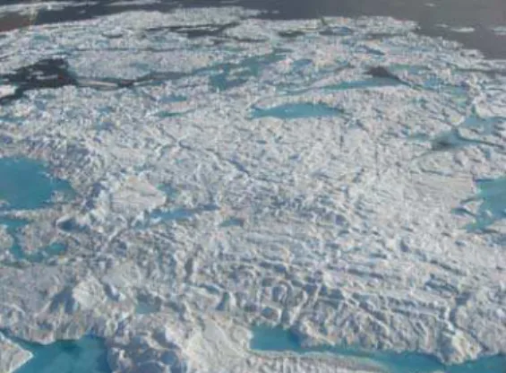
Figure 5 shows an aerial photograph of an approximately 200 m diameter multi-year ice floe near Little Cornwallis Island (75°40.49′N, 97°10.58′W) when it was visited in early July, just before breaking free of the landfast ice. The floe had extensive drainage patterns and ponded areas, some of which had virtually melted through the full thickness of ice (dark areas in ponds). On-ice measurements showed that the hummock on this particular floe was 8.0 m thick. Notice that the hummock had a well-defined peak/crest and that its sides were quite steep, considering that it was a multi-year floe.
Figure 5 Multi-year ice floe in the central Canadian Arctic, July
Key Identifiers for Differentiating Old Ice
The following key identifiers are used to help differentiate first-year, second-year and multi-year ice. The key identifiers are derived from the WMO nomenclature, the MANICE handbook, written and verbal communications from the Ice Service Specialists and the authors’ personal experience.
ponding/drainage: describes the accumulation of melt-water on the ice, mainly due to melting snow but, in the more advanced stages, also to the melting of ice. Summer melting produces a regular pattern of numerous small puddles on second-year ice, whereas the melt pattern on multi-year ice consists of large interconnecting irregular puddles and a well-developed drainage system (Figure 6).
hummocked and/or hillocked: area of uneven surface of ice that has been forced upwards by pressure (hummocked) or has formed from the natural weathering process (hillocked). Hummocks may be fresh or weathered. Often, it is not possible to distinguish between hummocks and hillocks, both of which give multi-year ice a “hill and dale” appearance (Figure 7).
color: puddles on second-year ice are usually blue or greenish-blue, whereas they are usually blue on multi-year ice (Figure 8). Both top surface of both types of ice can have granular ice that looks like snow, but is actually a product of weathering-induced, ice breakdown. Frequently, the areas of multi-year ice are often covered with debris, giving the ice a characteristic dirty appearance. Fragments of second-year ice overturned by a ship or structure are generally not as blue as multi-year ice.
Figure 6 Surface topography and drainage features of a multi-year floe
Figure 7 “Hill and dale” surface of multi-year ice
Figure 8 Blue, partially frozen melt pond on multi-year ice, August
floe size and shape: the shape of second-year and multi-year ice floes is rounded, compared to first-year ice floes that have sharper edges and an angular appearance.
freeboard: defined as how high the ice floats above the water. The freeboard can be used to gauge the ice thickness in spring and early summer (before the ice becomes saturated with water), when the relatively small voids are filled with mostly air and, to a lesser extent, brine. Later in the summer, old ice floes often float lower in the water, making them look deceptively thin.
ice thickness: second-year ice has a typical thickness of 2.5 m and sometimes more. Multi-year ice is typically up to 3 m or more thick. Caution is warranted because these estimates are for undeformed old ice – they do not include the increase in thickness due to mechanical forces (ridging, hummocking), nor do they reflect the decreased thickness of decaying second-year ice (less than 2.5 m) and some multi-year ice floes (less than 3 m).
snow cover: multi-year ice usually has a thicker snow cover than first-year ice. As a result, snow is present on the surface of multi-first-year ice long after the snow cover on first-year ice melts.
On-ice Measurements
Considerable effort was spent measuring the thickness of old ice in the 1980s in support of oil and gas exploration in the Beaufort Sea. Most of this information is in report form, and is part of the ‘grey’ literature (FENCO, 1973; Dickins, 1983; Kovacs, 1983; Wright et al., 1984), although some of that information was eventually made public (Dickins, 1989). Since that time, relatively little work has been done on multi-year ice, apart from the more recent measurements discussed in Johnston (2008-a). The Guide uses some of the recently conducted measurements on first-year ice Johnston (2006), second-year ice (Johnston et al., 2003) and multi-year ice (Johnston, 2008-b, c) to illustrate differences in the thickness and strength of the three types of sea ice, and show how their properties change during summer. In addition, the Guide includes recently acquired ice thickness transects from select multi-year floes. The transects were obtained from the eleven multi-year floes that were sampled in Nares Strait (Johnston, 2008-b) and four floes that were visited in the central Canadian Arctic Archipelago (Johnston, 2008-c). A total of more than 300 drill holes, and 2055 m of ice, was drilled on the 15 multi-year ice floes.
Transects were mapped out on each floe by placing flags at 10 m intervals and then using up to 17 m of 2” auger to drill holes through the ice at each flag. Having only 17 m of drill rod hampered ice thickness measurements in Nares Strait because it restricted drill hole measurements to the more level-looking areas and smaller hummocks on the multi-year floes (2008-b). Even then, however, the 17 m of drill rod was not sufficient to penetrate the full thickness of ice at some flags. The problem was compounded as the study progressed, because the number of usable drill rods diminished as they were damaged or lost down the 2” holes. The situation was remedied the following year by taking 30 m of drill rod.
Figure 9 and Figure 10 show the top and bottom surfaces of two multi-year floes, one in Nares Strait and the other in the central Canadian Archipelago. Transects on many of the floes in Nares Strait were made in what appeared to be a relatively smooth area. Despite the relatively level looking top ice surface, drill hole measurements showed that the underside of the ice was very rough (Johnston, 2008-b). Take, for
instance the floe in Figure 9 – the two holes where the ice was thicker than 15 m (the maximum drillable depth) appeared to be the same as the surrounding ice, but in fact the ice at those two holes was much thicker.
A comparison of top surface topography versus bottom topography could not be made for the floes in the central Canadian Arctic Archipelago because it was not possible to obtain a reliable measure of freeboard at each drill hole (Figure 10). The snow cover exceeded 1.0 m in places when the measurements were made in late May/early June, obstructing a clear view of the water level in the drill holes. The snow at each drill hole was shoveled initially, but was ceased because it slowed the crew (of three) to an unacceptable pace.
-20 -15 -10 -5 0 5 -140 -120 -100 -80 -60 -40 -20 0 20 Distance (m) Ice t h ickn e ss ( m ) top surface bottom surface
Figure 9 Top and bottom surface profiles of multi-year in Nares Strait. The ice thickness in two of the holes was thicker than 15 m , the depth to which the drill rod could penetrate.
-20 -15 -10 -5 0 5 0 20 40 60 80 100 120 Distance (m) Ic e thi c k n e s s ( m ) top surface bottom surface
Figure 10 Top and bottom surface profiles of multi-year in central Canadian Arctic Archipelago. The freeboard is reported for only holes where the snow cover was less than about 10 cm thick. The transect terminated part way up a 5 m high hummock, where the ice was 16.9 m thick.
SHIP-BASED OBSERVATIONS
The first two sections of the Guide, Background Information and
On-ice Measurements, help the reader understand the differences between second-year and multi-year ice, but they don’t necessarily help identify the different types of ice. That is the objective of the more than 70 ship-based and aerial observations in the Guide – to show the many facets of old ice, and document the key parameters that experienced personnel use to classify second-year and multi-year. The observations were generously provided the Ice Service Specialists (ISS) from the
Canadian Ice Service (CIS), two Commanding Officers (CO) acting in the capacity of ice observers on foreign ships, and a very keen student from the University of Manitoba. The 10 ships that participated in the program were all icebreakers, except for the M.V. Bremen. The
Bremen was an ice-strengthened cruse ship that navigated the Northwest Passage while one of the COs from the Canadian Coast Guard acted in the capacity of ice observer.
The 217 ship-based observations collected during the study were categorized into four arbitrarily defined, geographic regions: western Arctic, central Arctic, eastern Arctic and sub-Arctic (Figure 11). The number of observations collected from each of the 10 ships depended upon the region in which the ship operated and the time available for completing the two-page questionnaire described below.
CCGS Louis S. St. Laurent CCGS Terry Fox CCGS Des Groseilliers CCGC Amundsen CCGS Henry Larsen
CCGS Sir Wilfrid Laurier CCGS Pierre Radisson
M.V. Bremen I.B. Oden USCGC Healy
Figure 11 Ship-based observations collected during 3-year study
Collecting Ship-based Observations
Each year, the participants were given an observation booklet in which they were asked to complete two pages of questions about old ice features. The questions were divided into four sections: general information, detailed information, ground-truth information and ship response.
General information The observer was asked to record the date and time that the feature was encountered, the latitude and longitude of the ice feature, the filename of the digital photograph that was taken and whether the feature was observed from the ship’s bridge or from a helicopter (see section on Satellite Observations).
Detailed information Was the ice feature easy to identify, or difficult, and what were the key parameters used to identify it as second-year or multi-year ice? How confident was the observer classifying it as second-year or multi-year ice? In many cases, even highly experienced personnel had minimal confidence deciding whether the feature qualified as old ice or first-year ice. Levels of confidence ranged from less than 10% (extremely uncertain) to 100% (very sure). A comment box was included so that the observer could elaborate about what did, or did not, make the feature remarkable. Estimates of the floe size, freeboard and thickness of the ice were also asked for and, in many cases, best estimates were given.
Ground-truth information The observer was asked whether a satellite image was available for each observation and, if so, was the ice feature identifiable in the imagery? When satellite imagery was available, the observer was asked to indicate the ship’s position relative to the ice feature in the satellite image, and take a picture of the computer monitor. Having the photograph of the monitor was essential for identifying the floe in the imagery after the fact, because the ship-based observations and the satellite images were usually separated by at least one hour, and sometimes up to one day (during which time the floe continued to drift).
Ship response Did the ship impact the floe, at what speed and did the ship slow as it penetrated the floe? The observer also provided information about whether backing and ramming was required to penetrate the old ice floe, and whether the floe split.
Observations Included in the Guide
The observation booklets were the basis for the more than 70 ship-based observations that were included in the Guide. These observations represent the types of old ice that ships will encounter from July to October. To ensure that the observations were presented in a consistent manner, all observations in the Guide were reviewed by the authors and by one of the most experienced Ice Service Specialists (ISS). The review process was important, given that the observations were collected by more than 20 people, with various levels of experience. For the most part, however, the review process confirmed the original observations.
Large format photographs support each observation, illustrating the inclement conditions under which hazardous ice must be detected. The key identifiers used to determine whether a feature qualified as second-year ice or multi-second-year ice included those mentioned earlier (ponding, drainage features, thickness, color, etc.). The observer’s experience working in an area, history of the floe’s trajectory (from scientific instruments) and comparison to the surrounding ice also factored into the decision The fracture pattern of the ice also provided clues about the ice type. Most importantly, the sound of the impact left little doubt that the feature was multi-year ice: impacts with multi-year ice produce deep reverberations throughout the ship and cause a much “livelier” response than first-year or second-year ice. That said, it is not recommended that a ship impact an ice feature to determine what type of ice it is.
Example Observations
Three of the ice features encountered in Arctic and sub-Arctic are discussed below, along with the key identifiers used to recognize the ice, the level of confidence and information about the ship impact, where appropriate.
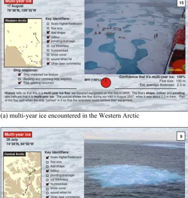
Western Arctic The floe in Figure 12-a is one example of multi-year ice in the northern Beaufort Sea (78°30′N, 139°32′W). The floe’s shape, color and ponding/drainage features indicated that it was multi-year ice. Scientific instruments had been used to track the floe for two years, which is why the observer was 100% confident that it was bona
fide multi-year ice. The ice in the image was 2.3 m thick when it was visited for the second time, in August, to recover the instrumentation. This particular floe provides a good example of the thinner types of multi-year ice that occur in the Beaufort Sea. Ships will also encounter extremely thick multi-year ice in the Beaufort Sea/Western Arctic, examples of which are also included in the Guide.
Central Arctic This 45 m diameter multi-year floe was encountered in the central Arctic in late July (Figure 12-b). It is an excellent example of a “sleeper” floe – the type of floe that is fairly small and lies so low in the water that detecting it in clear conditions is challenging, but even more so in foggy weather. This floe had some freeboard (compared to the rotten first-year ice nearby), the distinctive blue color of old ice, some evidence of hummocks and, most important of all, it had the characteristic sound of multi-year ice. Because of the ship response, the observer was 100% confident that it was multi-year ice.
(#10 LSSL) 15 Western Arctic 78°30’N, 139°32’W 17 August Multi-year ice
History multi-year ice floe shape colour ponding multi-year ice
tells us that this is a : we installed equipment on this floe in 2005. The floe’s , and also indicate that it is . The picture shows the floe during our visit in Part of the floe split when the ship “parked” in it so that the scientists could retrieve their equipment.
August 2007, when it was about 2.3 m thick.
Key identifiers: floats higher/freeboard floe size floe shape ponding/drainage ice thickness hummocked snow cover sound when hit other (see comments)
Backing and ramming was required Floe splitting occurred
Ship response:
Ship impacted ice feature
Floe size: 100 m
Confidence that it’s multi-year ice: 100%
Est. average thickness: 2.3 m 15
colour
MYI (100%)
(a) multi-year ice encountered in the Western Arctic
Central Arctic
74°39’N, 94°50’W 28 July Multi-year ice
Floe size: 45 m
Confidence that it’s multi-year ice: 100% Key identifiers: floats higher/freeboard floe size floe shape colour ponding/drainage ice thickness hummocked snow cover sound when hit other (see comments)
Backing and ramming was required Floe splitting occurred
Ship response:
Ship impacted ice feature 9
(#2 Gros)
Est. average thickness: ?
1 9
All of the old ice floes in this area are less than 100 m in diameter. Most are recognizable because of their ; there is no mistaking the blue, low floating floes as anything but old ice. Even though the floe floats low in the water, its
and it has , which characterize it as . The was
colour hummocks look very eroded extensive drainage features multi-year ice ice impact much ‘livelier’ than transiting through the rotten, first-year ice in the area - it tossed the ship around more.
MYI (100%)
(b) multi-year ice encountered in the Central Arctic
FYI (60%) (#4 Rad) 1 3 sub-Arctic 3 60°55’N, 64°23’W 26 June Second-year ice
The and on this floe suggest that it is but can’t really tell under these foggy conditions. Given the time of year and the location, it is probably that
ice thickness hummocked features second-year ice,
first-year ice hasn’t really started to decay yet. Floe size: 150 m Est. average thickness: 6 m
Confidence that it’s second-year ice: 40% Key identifiers: floats higher/freeboard floe size floe shape colour ponding/drainage ice thickness hummocked snow cover sound when hit other (see comments)
Backing and ramming was required Floe splitting occurred
Ship response:
Ship impacted ice feature
SYI (40%)
(c) second-year ice encountered in the sub-Arctic
Figure 12 Three Ship-based Observations in the Guide (a) Western Arctic, (b) Central Arctic and (c) sub-Arctic
Sub-Arctic The picture in Figure 12-c illustrates how foggy weather hampered the reliable detection of this 150 m diameter floe. The experienced observer had limited confidence in classifying it as second-year ice (40% confidence) because, although it had hummocks and appreciable thickness, given its location and the time of year the floe was more likely deformed first-year ice (60%). The sub-Arctic is one of the most difficult areas in which to classify the different ice types (B. Simard, personal communication). Fragments from first-year hummock fields can masquerade as second-year ice or multi-year ice. The overall thickness of the floe and its surface topography must not be the only parameters that are used to classify an ice feature.
AERIAL & SATELLITE OBSERVATIONS
Nearly all of the Canadian Coast Guard icebreakers have a helicopter onboard to assist with Search and Rescue (SAR), but also to help them “look ahead” at the ice conditions. Aerial reconnaissance provides detailed information over a fairly large area of ice. Many of the key parameters for identifying ice from a ship (surface topography, freeboard, ice thickness, etc.) are also used to recognize ice during an aerial reconnaissance. In fact, the aerial perspective provides a much better vantage point than the ship’s bridge for viewing drainage features – which is one of the most commonly used parameters for identifying old ice. Because of its better vantage point, aerial reconnaissance can be the deciding factor in classifying the ice as first-year, second-year or multi-year.
The satellite perspective provides even more synoptic coverage than aerial reconnaissance. RADARSAT is the most commonly used satellite for monitoring ice conditions in the Arctic because its frequency allows for good separation of first-year ice and multi-year ice throughout most of the year, except summer (R. DeAbreu, personal communication). Once the ice surface is covered by wet snow and/or melt ponds, even skilled interpreters have trouble distinguishing different types of ice, or even separating ice from water. Another limitation of satellite sensors (at present) is that they cannot be used to distinguish second-year ice from multi-year ice at any time of year, although exceptions do exist (Johnston and Sinha, 2001).
Figure 13 shows the 4 km diameter multi-year floe in Victoria Strait
(70°16′N, 99°47′W) encountered on 30 July at 13:13 UTC. The
RADARSAT ScanSAR image (nominal 100 m resolution) was obtained on 30 July 13:38 UTC. The floe is evident in the satellite image because it is large enough (4 km diameter) and it produces a brighter signature than the surrounding ice, most of which is decayed first-year ice. This floe was estimated to be about 2 to 3 m thick, and the observer was 100% confident that it was multi-year ice.
Figure 14 shows the 3 km diameter multi-year floe in Nares Strait (80°36′N, 68°04′W) that was visited on 24 August at 12:49 UTC. The RADARSAT Standard image (nominal 25 m resolution) was acquired on 24 August at 13:13 UTC. This floe is clearly evident in the satellite image, along with the many other multi-year ice floes drifting south in Nares Strait. There is no confusing multi-year ice with first-year ice at this time of year because all of the first-year ice has melted, or nearly so. As expected, the 25 m resolution of the Standard image (Figure 14) demarcates the floes much better than the 100 m resolution of the ScanSAR image (Figure 13).
Those are two examples of satellite imagery in which multi-year ice floes were successfully detected, but the also Guide contains many cases where multi-year ice could not be detected imagery – in either ScanSAR mode or Standard mode. The floes were too small, did not
have clearly demarcated boundaries, or surface melt obscured their detection. New sensors are being developed to improve the detection of ice, however until these sensors come on-line, visual detection must be the primary means of detecting hazardous ice.
King William Island
Figure 13 RADARSAT image of 4 km dia. multi-year floe
Figure 14 RADARSAT image of 3 km dia. multi-year floe
CONCLUSIONS
Various aspects of the guide Understanding and Identifying Old Ice in
Summer were discussed. The Guide was developed because no comprehensive tool on old ice exists to help with its identification, despite the need for ships to avoid it. On-ice measurements, large format photos from ship-based and aerial observations, and satellite imagery were used to demonstrate what makes multi-year ice the most hazardous type of ice, and how it can best be distinguished from
first-year and second-first-year ice. The more than 70 ship-based observations illustrate how difficult identifying ice types can be, given the range of conditions under which the mariner must operate in summer. The Guide is meant to supplement observations from the bridge or structure. It does not purport to be a replacement for real-time observations made from the bridge of a ship or a structure.
The term ‘old ice’ covers a broad spectrum, with good reason; differences between multi-year and second-year ice range from extremely subtle to obvious. In many cases, even observers with more than 30 years experience were not able to reliably identify different types of ice. Everyone who operates in the Arctic will encounter situations where the ice cannot be identified with reasonable confidence. It is imperative that personnel use due diligence when transiting or operating in ice-covered waters. That requires having as much information as possible to help identify different types of ice.
Understanding and Identifying Old Ice in Summer provides the end-user with one-more-tool for safe operations in ice-covered waters.
ACKNOWLEDGEMENTS
The financial support of the Canadian Climate Change Technology and Innovation Initiative (CCTII), Program of Energy Research and Development (PERD), Transport Canada and Canadian Ice Service is sincerely appreciated. The on-ice measurements were obtained from the years of the unflagging support generously provided by Transport Canada and PERD. Canadian Coast Guard and Polar Continental Shelf Project provided the logistical support for the on-ice measurements, and in many cases were enthusiastic participants in the work. The observations and meticulous notes of the ISSs, Captain J. Vanthiel, Captain N. Thomas and P. Wang are immensely appreciated. RADARSAT imagery for the Guide was provided by the Canadian Ice Service. The authors are indebted to A. Collins for her patience and diligence in compiling the three years of ship-based observations into digital form.
REFERENCES
Bjerkelund, C., Lapp, D., Ramseier, R. and N. Sinha (1984) The Texture and Fabric of Second-year Ice Cover at Mould Bay, Prince Patrick Island, NWT, April 1983. In proceedings of IG&RSS October 1985, p. 426 – 432.
Dickins D.F. (1983) Multiyear ice thickness distribution in the Beaufort Sea. Report for Gulf Canada Resources Inc.
Dickins, D.F. (1989) Multi-year Ice Thickness in the Beaufort Sea. 10th Intl. Conference on Port and Ocean Engineering under Arctic Conditions, 12 – 16 June 1989, Lulea, Vol. 1, p. 54 – 64. FENCO (1973) Beaufort Sea summer ice testing project. Report
prepared by the Foundation of Canada Engineering Corporation Limited (FENCO) for the Arctic Petroleum Operators Association (APOA), 16 p.
Johnston, M.E. and N.K. Sinha (2001) Physical Properties of Natural Sea Ice: Implications for Single and Multi-polarization SAR Images. 16th Intl. Symp. on Okhotsk Sea Ice, 4 – 6 February 2001, Mombetsu, Japan, 6 p.
Johnston, M.E., Frederking, R. and G. Timco (2000) Property Changes of First-year Ice and Old Ice during Summer Melt. Technical Report for Transport Canada, CHC-TR-010/TP 14098E, March 2003, 36 p. Johnston, M.E., Timco, G.W. and R. Frederking (2003) In Situ
Borehole Strength Measurements on Multi-year Sea Ice. 13th
International Offshore and Polar Engineering Conference (ISOPE) Honolulu, Hawaii, USA, May 25–30, 2003, p. 445 - 452.
Johnston, M.E. (2004) Properties of Second-year and Multi-year Ice during Freeze-up, Technical Report CHC-TR-024/TP 14292E, March, 2004, National Research Council Canadian Hydraulics Centre, Ottawa, Canada, 26 p.
Johnston, M.E. (2006) Comparison of Physical Properties and Strength of Decaying First-year Ice in the Arctic and sub-Arctic. Annals of Glaciology, 44, p. 154 – 162.
Johnston, M.E. (2008-a) Extremely Thick Multi-year Ice Still Exits, but Will it Last? ICETECH’08 Extended abstract, 20 – 23 July 2008, Banff, Canada, 2 p.
Johnston, M.E. (2008-b) Characterizing Multi-year Ice Floes in the High Arctic: Evaluating Two, Ground-based EM Sensors, controlled technical report CHC-CTR-073. National Research Council Canadian Hydraulics Centre, Ottawa, Canada, 70 p.
proprietary until January 2010.
Johnston, M.E. (2008-c) Thickness and Temperature of Multi-year Ice in Central Canadian Arctic Archipelago, Technical Report by National Research Council Canadian Hydraulics Centre, July 2008.
in print.
Kovacs, A. (1983) Characteristics of multi-year pressure ridges. 7th Int. Conference on Port and Ocean Engineering under Arctic Conditions (POAC), Helsinki, Vol. 3, p. 173-182.
Kubat, I. and G.W. Timco (2003) Vessel Damage in the Canadian Arctic. 17th Intl. Conference on Port and Ocean Engineering under Arctic Conditions, POAC’03, Vol. 1, p 203-212, Trondheim, Norway.
MANICE (2005) Manual of Standard Procedures for Observing and Reporting Ice Conditions, Canadian Ice Service - Environment Canada, ISBN 0-660-62858-9, Catalogue No. En56-175/2005. Melling H. (2002) Sea ice of the northern Canadian Arctic Archipelago.
J. Geophys. Res. 107, 3181.
Rigor. I.G. and J.M. Wallace (2004) Variations in the Age of Arctic Sea Ice and Summer Sea Ice Extent. Geophysical Research Letters, Vol. 31, L09401, 4 p.
Rigor, I.G., Wallace, J.M. and R.L. Colony (2002) Response of Sea Ice to the Arctic Oscillation, J. Climatology, Vol. 15, p. 2648 – 2663. Timco, G.W. and M. Johnston (2003) Ice Loads on the Molikpaq in the
Canadian Beaufort Sea. Cold Regions Science and Technology, Vol. 37, No. 1, p 51-68.
Timco, G.W. and M. Johnston, (2004) Ice Loads on the Caisson Structures in the Canadian Beaufort Sea. Cold Regions Science and Technology 38, p. 185-209.
Timco, G.W., Gorman, B, Falkingham, J., and B. O’Connell (2005) Scoping Study: Ice Information Requirements for Marine Transportation of Natural Gas from High Arctic, Technical Report CHC-TR-029, National Research Council Canadian Hydraulics Centre, February, 2005, Ottawa, Canada, 65 p.
Timco, G.W., Kubat, I., Johnston, M.E., O’Connell, B. and T. Carrieres (2008) The CCTII Arctic Transportation Project. 19th IAHR Intl. Symposium on Ice, Vancouver, British Columbia, Canada, 6 – 11 July 2008, 12 p. in print.
WMO (1970) World Meteorological Organization, WMO Sea-ice Nomenclature, Geneva, Secretariat of the World Meteorological Organization, WMO/OMM/BMO, No. 259, 147 p.
Wright B., Schwab D.L. and Gupta P. (1984) Beaufort Sea multi-year study - 1980. Report for Gulf Canada Resources Inc.