HAL Id: hal-00122516
https://hal-insu.archives-ouvertes.fr/hal-00122516
Submitted on 3 Jan 2007
HAL is a multi-disciplinary open access
archive for the deposit and dissemination of sci-entific research documents, whether they are pub-lished or not. The documents may come from teaching and research institutions in France or abroad, or from public or private research centers.
L’archive ouverte pluridisciplinaire HAL, est destinée au dépôt et à la diffusion de documents scientifiques de niveau recherche, publiés ou non, émanant des établissements d’enseignement et de recherche français ou étrangers, des laboratoires publics ou privés.
The Loyalty-New Hebrides Arc collision: Effects on the
Loyalty Ridge and basin system, Southwest Pacific (first
results of the ZoNéCo programme)
Yves Lafoy, François Missegue, Dominique Cluzel, Raymond Le Suavé
To cite this version:
Yves Lafoy, François Missegue, Dominique Cluzel, Raymond Le Suavé. The Loyalty-New Hebrides Arc collision: Effects on the Loyalty Ridge and basin system, Southwest Pacific (first results of
the ZoNéCo programme). Marine Geophysical Research, Springer Verlag, 1996, 18, pp.337-356.
The Loyalty-New Hebrides Arc Collision:
Effects on the Loyalty Ridge and Basin System, Southwest Pacific
(First Results of the ZoNéCo Programme)
YVES LAFOY', FRANCOIS MISSEGUE', DOMINIQUE CLUZEL3 and RAYMOND LE SUAVE4
'
Service des Mines et de l'Energie, BP 465, 98845 Nouméa cedex, Nouvelle-CalédonieLaboratoire de Géologie-Géophysique, Centre Orstom de Nounzéa, BP A5. UR 14, 98848 Nouméa cedex, Nouvelle-Calédonie Université Française du Pacifigue, CUNC, B.i! 4777, Nouméa, Nouvelle-Calédonie
IjirenierlCB, BP 70, 29280 Plouzané, France
I . ' I ' ' , , . , . . , . . . . " . - ' . , ' ,
(Received 2l'March 1995; accepted 18 August 1995)
_ r
Key words: Southwest Pacific, Loyälty Basin, Loyalty Ridge, New Hebrides I Arc collision, strike-slip tectonics
-
*
' The Southwest Pacific region in the area of study is
~ dominated by the subduction of the Australian plate
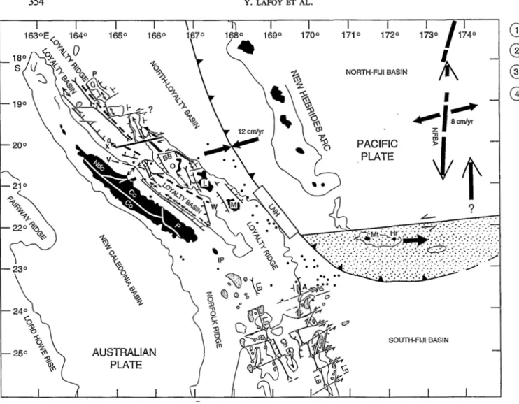
beneath the New Hebrides Arc at a rate of 12 c d y , with a direction of convergence that trends WSW- ENE (Dubois et al., 1977) (Figure 1). The subduction
GULWS collision between the Loyalty Ridge and the
New. Hebrides Arc. West of the collision zone, three
Abstract. The ZoNéCo 1 and 2 cruises of Ifremer's Research Vessel
L'Afalante, collected new swath bathymetry and geophysical data over the southern and northern segments of the basins and ridges formine the Lovaltv svstem. Between the two surveyed areas, previ-
-
- _ -
O U ~ studies found evidence for the resistance of the Loyalty Ridge
to subduction beneath the New Hebrides trench near 22" 5-169" E.
On the subducted plate, except for seismicity related to the down-
,parallel geological units that trend W - S E north of 22030'
s
and N-S south of this latitude are present.
from east to west (Figure 1):bending of the Australian plate, recorded shallow seismicity is sparse within the Loyalty system (Ridge and Basin) where reliable focal mechanism solutions are almost absent.
Swath bathymetry, seismic reflection and magnetic data acquired during the ZoNéCo 1 and 2 cruises revealed a transverse asymmetric morphology in the Loyalty system, and an along-strike horst and graben structure on the discontinuous Loyalty Ridge. South of 23'50' S and at 20" S, the two WSW-ENE-trending fault systems, respectively, sinistral and dextral, that crosscut the southern and northern segments of the Loyalty system, are interpreted as due to the early effects of collision with the New Hebrides Arc. A NNW-
SSE trend, evident along the whole Loyalty system and on the island
of New Caledonia, is interpreted as an inherited structural trend that may have been reactivated through flexure of the Australian lithospheric plate at the subduction zone.
Overall then, the morphology, structure and evolution of the southern and northern segments of the Loyalty system probably result from the combined effects of the Australian plate lithospheric bulge, the active Loyalty-New Hebrides collision and the overthrust of the New Caledonian ophiolite.
1. Introduction
The overall structure of the Southwest Pacific region can be summarised as resulting from successive open- ings of marginal basins that isolated ridges of either continental, oceanic or intermediate nature since _the late Cretaceous.
Mariize Geophysical Researches 1 8 331-356, 1996.
O 1996 Kluwer Academic Publishers, Printed in the Nefherlands.
1. The South-Fiji and North-Loyalty basins flank the Loyalty Ridge to the southeast and to the northwest respectively, except near 22" S-169" E where the Loyalty Ridge collides with the southern New Heb- rides Arc (Monzier et al., 1990). The New Hebrides
Arc has been active since the late Miocene (MacFar- lane et al., 1988). The South-Fiji Basin probably represents the southeastern extension of the North- Loyalty Basin (Collot er al., 1985).
2. The 1,000 km-long, 25 km-thick (Collot et al., 1982) Loyalty Ridge that bounds the Loyalty'Basin to the east, is made up of Oligocene (34-26 Ma) submarine alkaline volcanic rocks (Monzier, 1993), and of alkaline basalts dated 9-1 1 Ma (Bau- bron et al., 1976) that outcrop on Maré Island. During the Pleistocene, the lithospheric swell on the subducted Australian plate caused the uplift of the Loyalty Ridge (Dubois et al., 1974). In the vicinity of the Loyalty Ridge - New Hebrides Arc collision zone, sparse shallow seismicity on the subducting Australian plate reveals the activity of normal faults north and south of 22" S (Monzier, 1993). However, this author provided evidence for a W-E sinistral offset of the magnetic lineations of the Loyalty Ridge near 21'55' S. The sole known
-
15OS-
160s-
170s-
180s-
190s-
200s-
210s-
220st
I 240sa
PACIFIC
PLATE
250:USTRALIAN
PLATE
/
r O3
5
I O 22 (I, m SOUTH-FIJI BASIN w w CaFig. 1. Main structural features around New Caledonia. Bathymetry: 2,000 m isobath. 12 cdy.: Australian-Pacific plate convergence rate. GP: Grand Passage; P: Pétrie Reef: A: Astrolabe Reef: BB: Beautemps-Beaupré Atoll; IP: "Ile des Pins".
-18" -18"
-2T
-21' -22" -23" -24" - 2 5 O -26"THE LOYALTY-NEW HEBRIDES ARC COLLISIO1 339
1620 1 63" 184' ~ 165" 166" 167" 168' . 169" 170" 171" 172' -1 8" -18" -20" -21" -220 -23' -24' -25' -26' 1620 163" 164" 165' 166" 167' 168" 169' 170" 171' 172"
Fig. 2. Tracklines of the ZoNéCo 1 (Southern Box) and ZoNéCo 2 (Northern Box) cruises. Thick lines: location of seismic lines with, from south to north ZoNéCo 1 NNW-SSE-trending line PI6 (Figure 5), ZoNéCo 2 NWSE-trending line P75-1 (Figure lo), and ZoNéCo 2
WSW-ENE-trending line P37 (Figure 9).
strike-slip focal mechanism on the Australian plate lies near 21'30' S, east of Maré Island, and shows a dextral component (Monzier, 1993). On the over- riding Pacific plate, between 21'50' S and 22'10' S, the author reports a group of earthquakes with
W-E sinistral strike-slip focal mechanisms. The origin of the Loyalty Ridge is still much debated
(Kroenke, 1984; Monzier, 1993; Dupont et al., 1995).
3. The Loyalty Basin, bounded by the Loyalty and
the NorfolkINew Caledonia ridges, is 2,000 m deep in average. Numerous data on the Loyalty Basin were obtained during reconnaissance expeditions of petroleum exploration nature such as Gulf
340 Y. LAFOY ET AL.
!
i '
4.
(1972), Mobil Oil (1972), Austradec I (1972), and during scientific cruises Nova (Scripps Institution, 1965-67), Kimbla and Coriolis (1970-71), Geor- stom I and II (1973-19741, and Eva I, II, VI and VI1 (1976-78). In spite of the amount of data col- lected, a few publications have presented in an exhaustive way the structure and the history of the Loyalty Basin and its margin (Bitoun et Récy, 1982; Pontoise et aZ., 1982; Collot er al., 1982; Ravenne et al., 1982). Seismic reflection and refrac- tion data indicated that the structure of the Loyalty Basin was established after the obduction, in the upper Eocene, of the ophiolite nappe on the Nor- folWNew Caledonia Ridge. Originally, the ophio- lite nappe and the substratum of the basin, a 17 km-thick (Collot et al., 1982) Eocene oceanic crust
(Weissel et al., 1977) were continuous. The Loyalty
Basin is filled by post-Oligocene sediments (Ravenne et al., 1982). Bitoun et Récy (1982), iden-
tified from seismic reflection data, WSW-ENE- trending rises of the acoustic basement that they interpret as aseismic fracture zones that crosscut the Loyalty Basin and Ridge.
The Norfolk/New Caledonia Ridge, that connects to the south with the New Zealand North island. The N150" E northern segment of the ridge, or New Caledonia Ridge, was overthrusted in the late Eocene by the Caledonian ophiolites (Paris, 198l), and was then affected by a late Pliocene subsidence phase (Daniel et al., 1976). During
the late Miocene-Pliocene, a general uplift phase affected the New Caledonia region (Paris, 1981). Alkaline basaltic volcanism affected the eastern flank of the Norfolk Ridge 20 my ago (Daniel et
al., 1976).
New bathymetric and geophysical data were col- lected during the ZoNéCo 1 (26 June-I5 July, 1993) and ZoNéCo 2 (02-22 August, 1994) cruises aboard R N L'Atalante. Equipped with the EM 12 Dual multi-
beam system, seismic reflection, magnetic and gravi- metric equipment, L'Atalante performed two swath
bathymetric and geophysical surveys. southeast and northwest of the Loyalty-New Hebrides collision zone between 23'30' S-25'30's and 167"20 E-171" E, and 18'30' S-22'15' S and 162'50' E-168'20' E, respec- tively (Figure 2). This set of new data supports a de- tailed morphostructural study of the southern and northern segments of the Loyalty system, the Loyalty system being made of the Loyalty Basin and the Loy- alty Ridge. A new interpretation in terms of active collision between the Loyalty Ridge and the New Heb- rides Arc is proposed.
2. Data Acquisition
2.1. MULTIBEAM BATHYMETRY AND ACOUSTIC IMAGERY
The Simrad EM 12 Dual multibeam system aboard R N L'Atalante allows a swath up to 20 km-wide to
be mapped in one single pass, with both bathymetry and side-scan imagery. The EM 12 Dual system oper- ates at a frequency of 13 kHz, and consists of two separate multibeam echosounders (one to port and one to starboard), each generating 81 stabilised beams that provide a coverage up to seven times the water depth. The determination of energy and phase of the backscattered signal provides detailed bathymetry within the swath and displays a sonar image of the seabed reflectivity, both geometrically and bathyme- trically corrected.
2.2. SEISMIC REFLECTION
A six-channel seismic system was used, with 2 GI airgun sources that do not interfere with the EM 12 Dual echo sounder. This system allows a penetration of about 2.5 sec. TWT through sediments, when it is used at 10 knots. Sodera GI guns comprise a pulse generator and a bubble suppressor that fully suppress the oscillations of each individual bubble. The GI guns preserve the primary pressure pulse while eliminating the secondary pulse through precise tuning of an air injection within the bubble.
2.3. MAGNETICS
Magnetic data were acquired at a 6 sec sampling inter- val using a Barringer M-244 proton magnetometer, towed 280 meters astern the ship. Magnetic anomalies were computed by subtracting the IGRF 90 from the measured total field. but not corrected for diurnal vari- ations. As the accuracy of the magnetometer is equal to about 0.5 nT, cross-over errors are mainly due to diurnal variations.
3. Results of the ZoNéCo 1 and ZoNéCo 2 Cruises
3.1. THE SOUTHERN BOX: ZoNéCo I
3.1.1. Batliynzetrir Data
From west to east, the bathymetric map of the ZoNCCo 1 cruise, that surveyed the southern part of the Loyalty system (Basin and Ridge), shows (Figure 3):
1. The submerged part of the New Caledonia base- ment, that is represented by the N 160" E-trending.
i
II I I I I I I I I I
Ell67 E
Fig. 3. Bathymetric map of the Southern Box (ZoNéCo 1 cruise). Mercator projection WGS84, contour interval: 250 m; Dotted areas: Guyots; Shaded lines A to G and A' to E: W. lineaments across the Loyalty Ridge and the Norfolk / New Caledonia Ridge, respectively.
f:
-
.'.? 5 " ,,342 Y. LAFOY ET AL.
I
1 O00 m-deep Norfolk/New Caledonia Ridge. The ridge is composed of a shallow (1,000 to 1,500 m deep) plateau dotted with seamounts that culminate at 200 m. The plateau deepens to the south to reach 2,000 m depth. South of 24'10' S, the plateau has the form of a series of elongated and sigmoidal volcanic ridges that trend NNW-SSE, N-S and SSW-NNE. South of 24" S, these ridges are cros- scut by WSW-ENE-trending lineaments (A' to E') (Figure 3).
2. The N 160" E-trending southern part of the Loyalty Basin, 2,000 to 2,500 m deep, is characterised by a smooth topography. The Loyalty Basin deepens and widens southward, south of the WSW-ENE-trend- ing lineament B centred at 24'10's. South of this transverse lineament, the basin splits into two 2,500 m-deep, NNW-SSE depressions located west and east of a parallel central high threshold that ends south of 25'10' S.
3. The N160" E-trending Loyalty Ridge is made of elongated and tabular structures or guyots that culminate at 1,000 m, and of seamounts that locally cap the guyots. The ridge is discontinuous, being made of segments that trend SSW-NNE, NNW-SSE, WSW-ENE. It is crosscut south of 23"35'S, by WSW-ENE lineaments (A to G)
(Figure 3).
4. To the east, the northwestern corner of the South- Fiji Basin is characterised by a water depth of 4,000 m. At 23"40 S and 24"20' S in the basin there are two WSW-ENE volcanic features that culmin- ate at 1,000 m.
3.1.2. hlagrzeric Data
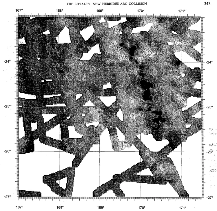
1 The magnetic anomaly map of the Southern Box con- firms the main structures and trends that characterise the southern parts of the NorfoWNew Caledonia Ridge and the Loyalty system in the study area (Figure 4):
1. To the west. the submerged part of the NorfolWNew Caledonia basement is characterised by N 170" E to N-S elongated magnetic anomalies, with peak to peak values in the range of +200 to +300 nT. 2. The Loyalty system is characterised by NNW-SSE
magnetic anomalies. The magnetic pattern of the Loyalty Basin comprises a series of parallel magnetic highs and lows that range between -200 and +200 nT. The magnetic signature of the Loyalty Ridge shows highs that reach a maximum of +400 nT. These NNW-SSE-trending magnetic highs are sinistrally offset along the ridge by WSW- ENE to W-E-trending faults. To the west, the WSW-ENE faults extend:
-
from 25" S-168" E to 24' S-170" E, where the transverse fault delimits the northern end of the Loyalty Basin central high and offsets the eastern margin of the Norfolk/New Caledonia Ridge;-
from 25'50' S-169" E to 25'10' S-170"30' E, where the transverse fault offsets the NNW-SSE magnetic lineations of the central high and the eastern depression of the Loyalty Basin. 3. To the east, the western edge of the northwesterncorner of the South-Fiji Basin contains diffuse WSW-ENE and NW-SE magnetic anomalies. 3.1.3. Seismic Reflection Data
Seismic reflection data reveal that the southern ends of both the Norfolk/New Caledonia and the Loyalty ridges are made of guyots and seamounts.
The generally NNW-SSE-trending Loyalty Ridge is made of a succession of guyots locally capped by uneroded seamounts, as shown on seismic line PI 6 on the eastern flank of the Loyalty Ridge (Figure 5). The guyots of the Loyalty Ridge trend NNW-SSE, SSW- NNE and NW-SE, their changes of direction occur- ring within WSW-ENE-trending grabens bounded by normal faults that delimit the guyots (Figure 5). These fault sets (A to F) bound the Loyalty Ridge guyots,
suggesting that the graben areas may represent poten- tial weak zones that have underwent recurrent faulting. On the eastern flank of the Norfolk/New Caledonia Ridge, WSW-ENE-trending lineaments B', C' and D'
are interpreted as strike-slip faults that sinistrally offset both the western Loyalty Basin and the eastern edge of the NorfolWNew Caledonia Ridge. The latter is dominated south of 24" S by elongated and sigmoïdal volcanic ridges made of seamounts.
Our interpretation of the seismic reflection data. coupled with petrological data (Daniel er al., 1976; Monzier, 1993), and the chronology of vertical move- ments that affected the region (Paris, 1981). enable us to associate the two types of volcanic structures (i.e. guyots and seamounts), with two distinct volcanic phases. The first volcanic phase, that created the guy- ots of the Norfolk/New Caledonia and Loyalty ridges, probably correspands to the submarine alkaline phase dated Oligocene-early Miocene by Daniel ef
a/. (1976) and Monzier (1993). The alkaline volcanic substratum might have become emergent during re- gional late Miocene-Pliocene uplift (Paris, 198 1 ). The guyots that resulted from this uplift might then have subsided during late Pliocene regional subsidence (Daniel rf al., 1976). The second volcanic phase, that gave rise to the uneroded seamounts, likely post-dated the late Miocene-Pliocene general uplift phase (Paris,
,
I
THE LOYALTY-NEW HEBRIDES ARC COLLISION 343
167" 168' 169' 170" 171' -24' -25" -26' -27' 167' 168" 169' 170' 171" ' -24O -25' I* ;,.>.
&"
.'f" .T(* -27'Fig. 4. Magnetic anomaly map of the Southern Box (ZoNéCo 1 cruise). Mercator projection WGS84, ¡so-anomalies are contoured at
100 nT intervals.
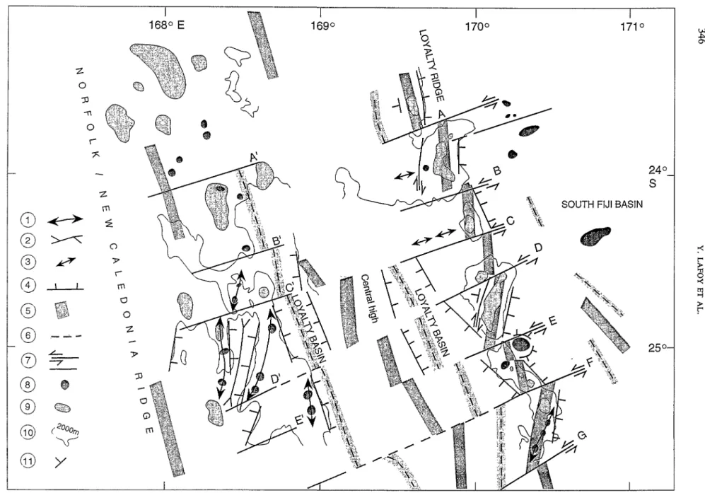
3.1.4. Ititerpretntion of the Structiiid Mcip 1. The structural map that results from the interpretation of seismic reflection and magnetic data (Figure 6), reveals that WSW-ENE-trending strike slip faults sinistrally offset both the Loyalty system, and the NorfolklNew Caledonia Ridge.
The structural map allows to define the relative ages of the fault sets:
A
NNW-SSE trend corresponds to the main struc- tural direction, as it parallels the Loyalty system basins and ridges and the eastern edge of the NorfolklNew Caledonia Ridge. Within the Loyalty Basin, the two NNW-SSE depressions and the central high are bounded by parallel normal faults. This NNW-SSE trend is increasingly disturbed to- ward the east, along the faulted Loyalty Ridge.P
16
SSE2
NNWP
16
SSE
I
I I l 20.00 00.00 4.00 O 20 km . ^Fig. 5. ZoNéCo 1 seismic line PI6 on the Loyalty Ridge. For location, see Figure 2. Vertical Exaggeration: 30; Vertical scale: Sec Two-Way-Time; G: Guyot; S: Seamount; A to F: faults within grabens.
. * k t ~
THE LOYALTY-NEW HEBRIDES ARC COLLISION 345
Grabens along the ridge were probably tectonically reactivated through recent strike-slip faulting. 2. A WSW-ENE trend is expressed through a trans-
verse strike-slip system that offsets the Loyalty Ridge guyots and extends westwards, deepening through the Loyalty Basin and the eastern edge of the Norfolk/New Caledonia Ridge.
3. A SSW-NNE trend occurs on the Norfolk/New Caledonia Ridge and its elongated volcanic ridges bounded by normal faults south of the 24'30' S
WSW-ENE lineament B'. On the Loyalty Ridge, the SSW-NNE trend is evident through either east- ward-dipping normal faults or through local dextral strike-slip faults.
k
:.
3.2. THE NORTHERN BOX: ZoNéCo 2 . 3.2.1. Bathymetric DataFrom west to east, the bathymetric map of the ZoNéCo 2 cruise, that surveyed the northern part of the Loyalty system (Basin and Ridge), reveals the morphology of both the eastern margin of New Caledonia and the Loyalty system (Figure 7). Three main units can be defined from west to east:
1. The eastern margin of New Caledonia, charac- terised by a pronounced change in morphology, north and south of a bathymetric high centred at 20"40'S. North of 20"40' S, the margin is a broad seaward-concave curve cut by canyons, whereas south of this latitude, the margin is rectilinear and steep and devoid of canyons.
2. The Loyalty Basin, characterised by a general NW-SE trend and a flat floor. The basin deepens to the north and can be divided north and south of 20'40' S, into:
-
a northern N 135" E part, 75 km-wide, that deep- ens from 2,500 m near 20"20'S, to 3,800 m at 18'40' S. The basin is asymmetric, with its deepest part lying along the western edge of the Loyalty Ridge. The western side of the basin is dotted with volcanoes at 19' S and 19'55's and with N 135" E-trending small ridges at 18'50' S and 20'05' S;- a flat-and-smooth N125" E-trending southern part, 45 km-wide and 2,200 m-deep, that slightly dips to the SW.
The Loyalty Basin abruptly deepens to the north, north of the 20'40' S high that is cut to the south- east by the NNW-SSE-trending, northward- flowing channel centred at 20'20's.
3. The Loyalty Ridge, that trends NW-SE, and its northward submarine extension defined by Beau- temps-Beaupré Atoll and by the Astrolabe and Pétrie
2 ' '
'
reefs (Figure 7) are made of guyots and seamounts. The Loyalty Ridge can be divided, north and south
of 20"10' S, into a N 135" E-trending segment and a N125" E-trending segment, respectively.
3.2.2. Magnetic Data
The magnetic anomaly map of the Northern Box con- firms the main structures and trends that characterise the northern part of the Loyalty system. From east to west (Figure 8):
1. The Loyalty Ridge and its eastern edge are charac- terised by high magnetic values. They reach
+
500 nT on and east of the Loyalty Islands, and decrease to the north with average values of +300 nT on, Astrolabe and Pétrie reefs. At 20' S, the overall pos-
itive magnetic anomaly signature of the ridge is crosscut by a W-E-trending negative lineation. At this latitude, the positive signature of the Loyalty Ridge that changes direction from N 135" E north of 20" S to N 125" E south of this latitude, is slightly dextrally offset.
2. The northern part of the Loyalty Basin, north of 20" S, characterised by N 135" E-trending linea- tions, is dominated on its eastern side by a magnetic low that occurs with a minimum of -400 nT at 20" S. This N 135" E-trending magnetic low, that represents the overall signature of the Loyalty Basin northern part, lies along the western side of the Loyalty Ridge. At 20" S, this lineation bends to the east where it trends WNW-ESE to W-E, and crosscuts the Loyalty Ridge. At the western side of the basin a NNW-SSE-trending magnetic high reaches a maximum of
+
100 nT.3. Between 20" S and 20"40'S, the central part of the Loyalty Basin is characterised by transverse lineations that mainly trend WNW-ESE. The N125" E-trending magnetic low that occurs with a minimum of -200 nT at 20'20' S, 165'30' E, represents the signature of the basin, this signature disappearing southward. The N 125" E-trending low is dextrally offset from the N135" E-trending, -400 nT magnetic low of the northern part of the basin. The dextral offset between the N 135" E and N 125" E-trending magnetic lows north and south of 20" S, is confirmed by the sigmoïdal geometry of the lineations, respectively curved eastward and westward.
4. The southern part of the Loyalty Basin, south of 20'40' S, characterised by N 125" E to N 130" E lin- eations, is dominated on its eastern side by a N125" E magnetic low. This negative lineation that occurs with a minimum of -400 nT and extends from 21'40's south of Lifou Island to 20'40's
z
O P -no
r
---.z
mf
o
9 r m O Oz
4 9 1 168O E 1690 1 170°
1 171 O 24 0-s
SOUTH FIJI BASIN
25 O-
-
w
Fig. 6 . Structural map of the Southern Box. 1: ridges; 2: depressions; 3: buried highs; 4: normal faults; 5: positive magnetic lineation; 6: negative magnetic lineation; 7: strike slip/ vertical-throw faults: 8: seamounts: 9: euvots: 10. 2.000 m isobath: 11: structures’ din.
’
P
164OE 165OEI
348 Y. LAFOY ET AL.
where it bends to the west, represents the signature of the southern part of the basin. To the southwest, a N 130" E magnetic high that reaches a maximum of
+
300 nT near 21"30' S underlines the western edge of the southern part of the basin.3.2.3. Seismic ReJectioii Dafa
Seismic reflection data reveal the asymmetric morphol- ogy and structure of the Loyalty system.
The Loyalty Ridge and its submarine northern exten-
d sion can be divided, north and south of 2O"lO' S, into:
-
a N 135" E-trending northern segment, made up of NNW-SSE-trending guyots that culminate at 800 m. They are bounded north and south by WSW- ENE faults, and west and east by NNW-SSE and NW-SE-trending normal faults, respectively. The NNW-SSE-trending highs are tilted toward the east, as shown on seismic line P37 that crosses the eastern flank of the Loyalty Ridge (Figure 9). All along the Loyalty Ridge, the guyots and their bounding faults reflect a horst and graben structure;-
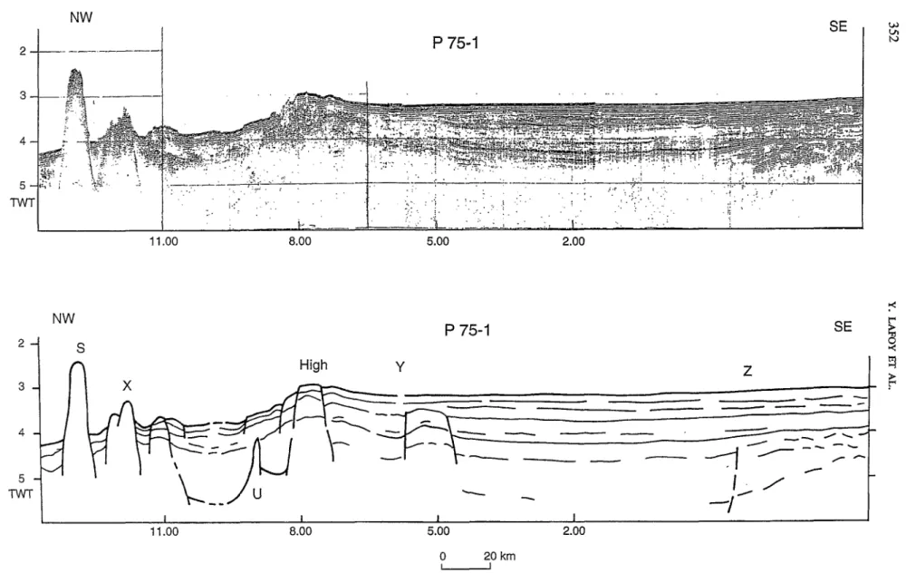
a N 125" E-trending southern segment, bounded west and east by " W - S S E and NW-SE-trending scarps, respectively. Between the outcropping islands, like in the northern segment, the main structural features trend NNW-SSE and are locally offset by WSW-ENE-trending faults.Within the Loyalty Basin, the seismic data reveal the difference of structure of the basin north and south of the northeastward-deepening extension of the 20'40' S high. Seismic line P75-1 shows the along-strike structure of the Loyalty Basin (Figure 10). The 2200 m- deep, N 125" E-trending southern part of the basin is filled by sediments that reach a maximum thickness of 3.5 sec. TWT, whereas in its deeper (3000 to 3700 m) northward-dipping N 135" E-trending northern part, the sedimentary filling is less than 2 sec. TWT (Figure 10). The structural 20"40' S, SW-NE-trending high is bounded to the north by a WNW-ESE scarp that delimits the deep. faulted central part of the Loyalty system, and to the south, by a NNW-SSE scarp. South and north of the 20"40' S high, five main acoustic base- ment upraises occur (Figure 1 O). The southern upraises (Y, underlain to the channel in the Loyalty Basin west of Ouvéa, and southeast of fault Z on Figures 10 and 11) trend NNW-SSE. To the north. acoustic high U trends WNW-ESE (Figures 10 and 11). The two north- ernmost acoustic basement upraises (X and S on Figure 10) are cropping-out to the surface at 20'05' S
and 19'55' S. along a small N 135" E-trending ridge and a volcano (Figure 11) that culminate at 2400 m and 1720 m, respectively. The 30'05' S upraise deepens eastward within the Loyalty Basin.
3.2.4. Interpretation of the Structural Map
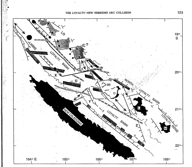
The structural map (Figure 11) allows to define the relative ages of the fault sets:
1. The NW-SE direction, that parallels the general trend of New Caledonia, the Loyalty system, the western edge of the North-Loyalty Basin, charac- terises the New Caledonia-Loyalty Basin boundary structurally controlled by a westward-dipping normal fault. The general NW-SE trend of the Loyalty system slightly changes north and south of about 2O"lO'S to N 135" E and N 125" E, respec- tively.
2. The NNW-SSE direction characterises the Loyalty Ridge's blocks bounded north and south by WSW- ENE faults. The NNW-SSE trends of the canyon located at 21"s between Ouvéa and Lifou and the channel in the Loyalty Basin, at 20"20'S, 165'40' E are structurally controlled by this fault set.
3. The WSW-ENE-trending faults that crosscut the Loyalty Ridge are either vertical-throw faults hounding the ridge's horsts or strike slip faults that offset the ridge either sinistrally at 19'20' S and 20"15'S, or dextrally at 20" S (Figure 11). At this latitude, south of l'Astrolabe reef, a major WSW- ENE-trending fault extends from 164'55' E to
166" E and crosscuts the Loyalty system. This fault, located where the basin abruptly deepens to the north, probably corresponds to a vertical-throw fault. However, magnetic data indicate that the NW-SE-trending lineations of the Loyalty basin and ridge, respectively negative and positive, are dextrally offset from about 30 km along this trans- verse fault. Furthermore, seismic reflection data re- veal that the WSW-ENE-trending fault zone, characterised by an upraise of the acoustic hase- ment, outcrops westwards near 20'05's ( X on Figure lo), at its junction with the NW-SE-trending New Caledonia
-
Loyalty Basin boundary (Figure 11). We interpret the 20" S WSW-ENE fault as a fracture zone, confirming previous studies of Bitoun et Récy (1982). This pre-existing potential weak zone is recently reactivated into a dextral strike-slip fault.4. WNW-ESE directions are present between the 20'40' S SW-NE-trending high and 20' S, along the eastern margin of New Caledonia and within the central part of the Loyalty Basin. These trends are, to the west, normal faults bounding the 20'40's high northern flank, and to the east, scarps that abut against the NNW-SSE-trending margin of the Loyalty Ridge.
i
-19"
-20"
-2
1"
-22"
-23"
I
1:' ',
:i
j
-19"
-20"
-21"
-22"
-23"
163"
16pO
165"
.166"
167"
.168"
169"
Fig. 8. Magnetic anomaly map of the Northern Box (ZoNéCo 2 cruise). Mercator projection WGS84, iso-anomales are contoured at 100 nT intervals.
350 Y . LAFOY ET AL.
P37
I
!
/
THE LOYALTY-NEW HEBRIDES ARC COLLISION 351
4.
DiscussionIn
contrast to other subduction zones, the shallow seismicity in the New Hebrides Arc cannot be de- scribed easily due to the structural complexity of both the subducted and overlying plates (Louat et al., 1988).Bathymetric irregularities such as the d'Entrecasteaux fracture zone and the Loyalty Ridge occur on the subducted plate near the plate boundary.
Between 14"30 S and 17" S, the subduction of the d'Entrecasteaux zone forces the north and the south section of the New Hebrides Arc to separate rigidly away from the central block, and develops strike-slip motion along the lateral boundaries of the central block (Collot et al., 1985).
Although on the scale of the Loyalty Ridge collision physical indentation does not really occur (i.e. the New Hebrides trench is still present, recorded shallow seis- micity on the subducting plate indicates mainly normal faulting), the coupling between lower and upper plates may be strong enough to generate horizontal com- pressive stresses.
Within the collision zone, Monzier et al. (1990) and
Monzier (1993) found evidence for the accretion of Loyalty Ridge blocks on the inner wall of the New Hebrides trench, and interpreted it as due to the resis- tance of the ridge to subduction. They identifed that the interplate thrust zone shifted towards the trench and the compressive front jumped on the outer trench wall. According to these authors, a different evolution of the convergence occurs north and south of 22" S where a W-E sinistral strike-slip fault affects the arc and the edge of the downgoing plate.
West of the collision zone, along the Loyalty system basins and ridges, Bitoun et Récy (1982) published an isochron map of the acoustic basement based on
seismic reflection profiles. They identified rises of the acoustic basement located near 17" 15' S, 18"40' S, 20'10' S, and 23" S, and interpret these sills as WSW- ENE-trending aseismic fracture zones that crosscut the basin. However, these authors report two earth- quakes of magnitude 3.5 and 3 (1979) aligned on the 2O"lO'S sill.
Despite the absence of reliable focal mechanism so- lutions, we think that these two earthquakes may indi- cate recent reactivation of the WSW-ENE-trending fault zone, .through strike slip motion. The 20" S
+-- Fig. 9. ZoNBCo 2 seismic line P37 that crosses the Loyalty Ridge
horsts. For location, see Figure 2. Vertical Exaggeration: 25; Vertical scale: Sec.Two-Way-Time; LB: Loyalty Basin; LR: Loyalty Ridge;
NLB: North-Loyalty Basin.
WSW-ENE-trending dextral strike-slip fault, prob- ably recent as it affects the whole Loyalty system and outcrops at the junction with the New Caledonia -
Loyalty Basin boundary, confirms the dextral strike- slip component of the 21'30' S earthquake, east of Maré (Monzier, 1993).
The identification of the Loyalty system structural features shown in Figure 12, is basedon the interpreta- tion of the swath bathymetry, seismic reflection and magnetic data acquired during the ZoNéCo 1 and ZoNéCo 2 cruises.
North of the Loyalty Ridge-New Hebrides Arc col- lision zone, the 20" S WSW-ENE dextral fault system is interpreted as due to the early effects of collision with the New Hebrides Arc. According to Monzier (1993), north of 22" S, the intense collision does not totally prevent the convergence, normal to the trench and driven by the subduction of the oceanic lithosphere
of the North-Loyalty Basin. We interpret the 20"s WNW-ESE dextral system as a boundaring sliding fault zone within the northern segment of the Loyalty system (Lafoy et al., 1995b). North of 20" S, the N135" E-trending part of the Loyalty system is domin- ated by the subduction of the North-Loyalty Basin oceanic crust. South of 20'S, between this latitude and 22" S, the N125" E-trending part is subjected to the Loyalty-New Hebrides collision.
South of the Loyalty Ridge-New Hebrides Arc colli- sion zone, south of 23'50' S, magnetic and seismic re- flection data support a sinistral motion along the WSW-ENE strike-slip faults. These faults crosscutthe generally NNW-SSE-trending Loyalty system. There- fore, the WSW-ENE sinistral fault system in the south- ern segment of the Loyalty system is interpreted as due to the early effects of collision with the New Heb- rides Arc (Lafoy et al., 1995a). South of 23"50' S, the NNW-SSE-trending Loyalty system is dominated by the subduction of the South-Fiji Basin oceanic crust subjected to fracturing by the WSW-ENE sinistral faults. Between 23'50' S and 22" S, the arc microplate is probably strongly coupled with the Australian plate (Monzier, 1993) and the Loyalty system is subjected to the Loyalty-New Hebrides collision.
The NNW-SSE trend that structurally controls the Loyalty system is present on the New Caledonian mainland (Figure 12). A main fault separates the units of the "central chain" to the west, and the "ophiolites" to the east (Paris, 1981; Cluzel et al., 1994). The NNW- SSE trend therefore might be an inherited structural direction as it affects both New Caledonia and the Loyalty system. We think that this trend might have been reactivated through extension related to the AUS- tralian plate lithospheric bulge.
:x);
2
a
4 5 Tw NW --.---.--I
SE
P
75-1
11 .o0 8.00 5.00 2.00P
75-1
w VI h, 9 SE NW2
F
---
11 .o0 8.00 5.00 2.00o
20 kmFig. 10. ZoNéCo 2 seismic line P75-1 that crosses the Loyalty Basin. For location, see Figure 2. Vertical Exaggeration: 25; Vertical scale: SecTwo-Way-Time: S: 1935's seamount; X: ?0"05'S. N 135" E-trending ridge; U, Y acoustic basement upraises north and south of the 20'40 S structural high northeastward extension; Z: fault that delimits to the southeast a
basement upraise.
,
8 1 ' 'THE LOYALTY-NEW HEBRIDES ARC COLLISION 353
19"-
S
200-
21 O-
Fig. ll. Structural map of the Northern Box. For Figure caption see Figure 6. L R Loyalty Ridge; P: Pétrie Reef; A Astrolabe Reef; BB: Beautemps-Beaupré Atoll; O, L, M Ouvéa, Lifou and Maré islands; X, U, Y, 2: see Figure 10 for caption.
Sinistral strike-slip faults ,that offset the Loyalty Ridge N 135" E and N 125" E-trending guyots at 19'20' S and 20'15' S, respectively, probably pre-date the recent collision.
As stated by Monzier (1993), the onset of the colli- sion is probably recent (began some 300 O00 years ago). However, we think that the Loyalty Ridge probably influences, since about 3 Ma when the activity of the North Fiji Basin N-S spreading axis started (Auzende
et al., 1988), the subduction at the southern arcuate New Hebrides trench, through its action on the bulge of the downgoing plate. On the overriding Pacific plate,
the Loyalty-New Hebrides collision may have caused the activity of the 22's W-E sinistral fault (Monzier, 1993) that crosscuts the southern part of the North Fiji Basin (Figure 12), and that probably represents the recent southern boundary between the Australian and Pacific plates.
5. Conclusions
New bathymetric and geophysical data were acquired at the southern and northern segments of the Loyalty
i
354 Y. LAFOY ET AL.
I
1I
\ I
-h
I I II
I IFig. 12. Interpretative sketch of the Loyalty
-
New Hebrides collision (LNH). For abbreviations and symbols, see previous Figures. 1: positive magnetic lineations along the Loyalty Ridge; 2: negative magnetic lineation within the Loyalty Basin; 3: guyots and seamounts; 4: shallow earthquake distribution on the subducted plate (from Monzier, 1993, with year-1979 earthquakes of magnitude 3.5 and 3 reported by Bitoun et Rky, 1982); LB: Loyalty Basin; Ch: Central high; LR: Loyalty Ridge; V-W probable eastem edge of the New Caledonian ophiolite; Co, Ndc, CC, P Onland New Caledonian geological Units “Côte Ouest, Nord-Calédonien, Chaine Centrale, Péridotites”, respectively (simplified from Cluzel er al., 1994); NFBA North Fiji Basin Axis; 8 cmly.: NFBA spreading rate (from Auzende et al., 1988); Shaded: Matthew (Mt)-
Hunter (Hr) microplate (modified from Monzier, 1993).system during the ZoNéCo 1 and 2 cruises, respectively. These data reveal the along-strike horst and graben structure of the Loyalty Ridge and the asymmetric morphology of the Loyalty system.
Along the southern segment of the Loyalty system, south of the Loyalty Ridge-New Hebrides Arc colli- sion zone, in spite of sparse shallow seismicity that indicates normal faulting on the down-bending Australian plate, magnetic and seismic reflection data support a sinistral motion along the WSW-ENE faults. South of 23’50 S, WSW-ENE strike-slip faults crosscut the generally NNW-SSE-trending Loyalty
system
-
NorfolWNew Caledonia Ridge. The WSW- ENE sinistral fault system in the southern segment of the Loyalty system is interpreted as due to the early effects of collision with the New Hebrides Arc. South of 23”50 S, the subducted South-Fiji Basin oceanic crust is fractured by WSW-ENE sinistral faults, whereas north of 23’50’ S the eastern edge of the Loy- alty system is subjected to the Loyalty-New Hebrides collision.Along the northern segment of the Loyalty system, north of the Loyalty Ridge-New Hebrides Arc colli- sion zone, magnetic and seismic reflection data give
THE LOYALTY-NEW HEBRIDES ARC COLLISION 355
evidence for a WSW-ENE dextral strike-slip system, confirming the sole known strike-slip earthquake mechanism solutidn identified on the Australian plate, near 21’30‘ S. Therefore, we interpret the 20” S, WSW- ENE dextral fauit in the northern segment of the Loy- ‘
alty system as resulting from the early effects of collision with the New Hebrides Arc. The WSW-ENE strike-slip fault ïs interpreted as a boundaring sliding fault zone with, north of 20°S, subduction of the North-Loyalty Bash oceanic crust, and south of this latitude, collision between the Loyalty system and the New Hebrides Arc.
The Loyalty-New Hebrides collision is inferred from our’data, both by the recent fracturing of the Loyalty system (at 20” S and south of 23”50‘ S), and by the uplift of the central part of the Loyalty Basin. This uplift probably took place along the 20”40’S, SW-NE-trending structural high that marks morpho- logical changes in both the Loyalty Basin and the New Caledonia eastern margin.
South of the 20’40’ S high, the NW-SE-trending negative magnetic lineation that extends southward within the Loyalty Basin, could represent the eastern edge of the New Caledonian ophiolite.
The NNW-SSE trend, that structurally controls the Loyalty system south and north of the Loyalty-New Hebrides collision zone, and that occurs on New Cale- donia, is interpreted as an inherited structural direc- tion. This trend may have been reactivated through extension related to bulging of the Australian plate adjacent to the trench.
We interpret the morphology, structure and evolu- tion of the Loyalty system as resulting from the com- bined effects of the Australian plate lithospheric bulge, the active Loyalty-New Hebrides collision, and the overthrust of the New Caledonian ophiolite.
Acknowledgements
The ZoNCCo 1 and ZoNCCo 2 cruises were carried out under the ZoNCCo programme, aimed at under- .standing the geology and geodynamics and providing detailed information on the marine resources of the two surveyed areas. We thank the Territory and the three Provinces of New Caledonia, the research organ- isations Ifremer, Orstom and the French University of the Pacific (UFP). We thank the captains of the R/V
L’Atalante and their crew for their expertise during
the ZoNCCo 1 and 2 surveys. We also acknowledge the Genavir and Ifremer technical staff for the on board acquisition and processing of the data. .
References
Amende, J. M., Lafoy, Y. and Marsset, B., 1988, Recent Geodynamic Evolution of the North Fiji Basin (SW Pacific). Geology 16,925- 929.
Baubron, J. C., Guillon, J. H. and Récy, J., 1976, Géochronologie par la Méthode WAr du Substrat Volcanique de l’ile Maré
-
Archipel des Loyauté (Sud-Ouest Pacifique). Bull. BRGM, (2), Bitoun, G. and et Récy, J., 1982, Origine et évolution du bassin des Loyauté et de ses bordures apr& la mise en place de la série ophiolitique de Nouvelle-Calédonie, in Equipe de Géologie-Géo- physique du Centre ORSTOM de Nouméa. Contribution à l’étude Géodynamique du Sud-Ouest Pacifique. Travaux et Documents Cluzel, D., Aitchison, J., Clarke, G., Meffre,’S. ef Picard, C., 1994, Point de vue sur l’évolution ,tectonique et géodynamique de la Nouvelle-Calédonie. C. R Acad. Sci., t. 319, Série II, 6, 683- 690.Collot, J. Y., Missegue, E and Malahoff, A., 1982, Anomalies gravi- métriques et structure de la croûte dans la région de la Nouvelle- Calédonie: enracinement des péridotites, in Equipe de Géologie- Géophysique du Centre ORSTOM de Nouméa. Contribution à l’étude géodynamique du Sud-Ouest Pacifique. Travaux et Docu- ments ORSTOM 147, 549-564.
Collot, J. Y., Daniel, J. and Burne, R. Y, 1985, Recent Tectonics Associated with the SubductionlCollision of the d’Entrecasteaux Zone in the Central New Hebrides. Tecfonophysics 112, 325- 356.
Daniel, J., Dugas, E , Dupont, J., Jouannic, C., Launay, J., Monzier, M. et Récy, J., 1976, La zone charnière Nouvelle-Calédonie
-
Ride de Norfolk (S.W. Pacifique) - Résultats des dragages et interprétation. Cali. ORSTOM, sér.Géo1. 1, 95-105.Dubois, J., Launay, J. and Récy, J., 1974, Uplift Movements in New Caledonia-Loyalty Islands Area and their Plate Tectonics Interpretation. Tectonopliysics 24 (1/2), 133-150.
Dubois, J., Launay, J., Récy, J. and Marshall, J., 1977, New Hebrides Trench: Subduction Rate from Associated Lithospheric Bulge. Can. .l Earth Sci. 14, 250-255.
Dupont, J., Lafoy, Y., Pautot, G., Le Suavé, R., Cluzel, D., Missegue, E, Grandperrin, R., Hénin, C., Voisset, M., Durand Saint Omer, L., Gautheron, L., Butscher, J., Mollard, L., Rakoia, M. et le groupe ZoNéCo à bord de L ‘ATALANTE, 1995, Etude mor- phostructurale de la zone sud des rides Nouvelle-Calédonie et Loyauté (ZEE de Nouvelle-Calédonie, Pacifique Sud-Ouest). C.
R. Acad Sci. Paris, t. 320, Série IIa, 211-218.
Kroenke, L. W., 1984, The New Caledonia: TheNorfolkand Loyalty Ridges, chap. 2, Cenozoic Tectonic Development of the Southwest Pacific with a Contribution by Peter Rodda, Cotnmiftee for Co- ordinaiion of Joint Prospecting for Mineral Resources it1 South Pacific Offshore Areas, Suva, FIJI, Tech. Bull. 6, 15-28. Lafoy, Y., Dupont, J., Missegue, E , Le Suavé, R. et Pautot, G.,
1995a, Effets de la collision “ride des Loyauté
-
arc des Nouvelles- Hébrides” sur la terminaison sud de 1 ‘ensemble “Nouvelle-Calé- donie-Loyauté”. C. R Acad. Sci. Paris, t. 320, série IIa, 1101- 1108.Lafoy, Y., Missegue, E , Cluzel, D., Voisset, M., Saget, P., Lenoble,
J. P., Rigaut, E et Bouniot, E., Cornec, J., De Souza, K., Gallois, E , Garioud, N., Grenard, P., Lanckneus, J., Lehodey, P., N ‘Diaye, M., Perchoc, Y., Perrier, J., 1995b, Morphostructure du segment septentrional du “systéme” Loyauté (bassin et ride), Sud-Ouest Pacifique: résultats de la campagne ZoNéCo 2, C. R Acad. Sci., t. 321, série IIa, 1009-1016.
IV, 3, 165-175.
356
Louat, R., Hamburger, M. et Monzier, M., 1988, Shallow and Inter- mediate-Depth Seismicity in the New Hebrides Arc: Constraints on the Subduction Process, in Greene, H. G. et Wong, E L. (eds.), Geology and Offshore Resources of Pacific Island Arcs, Vanuatu Region, Circum-Pacific Councilfor Energy and Mineral Resources, Houston, Texas, Earth Sci. Ser. 8, 329-356.
MacFarlane, A., Camey, J. N., Crawford, A. J. and Greene, H.G ., 1988, Vanuatu: A Review of the Onshore Geology, in Greene, H.
G. and Wong, E L. (eds.), Geology and Ofshore Resources of
Pacific island Arcs- Vanuatu Region, Circum- Pacific Council for Energy and Mineral Resources, Houston, Texas, Earth Science Series 8,45-91.
Monzier, M., 1993, Un modèle de collision arc insulaire-ride océanique. Evolution sismo-tectonique et pétrologique des vol- canites de la zone d’affrontement arc des Nouvelles-Hébrides
-
Ride des Loyauté. Thèse Université Française du Pac@que, Nou- méa, 2 vol., 322 p., 1 carte annexe.Monzier, M., Daniel, J. et Maillet, P.. 1990, La collision “Ride des Loyauté/Arc des Nouvelles-Hébrides” (Pacifique Sud-Ouest).
Y . LAFOY ET AL.
.I L
-e- t
i
*
Oceanologica Acta, spécial 10, Actes du colloque: Tour du Monde “Jean Charcot”, Paris, 1989,43-56.
Paris, J. P., 1981, Géologie de la Nouvelle-Caltdonie: un essai de synthèse. Mémoire BRGM 113,279 p., 1 carte H.T. (2 coupures). Pontoise, B., Collot, J. Y., Missegue, E et Latham, G., 1982, Sismique réfraction dans le bassin des Loyauté: Résultas et discussion, in Equipe de Géologie-Géophysique du Centre ORSTOM de Nouméa. Contribution à l’étude géodynamique du Sud- Ouest Pacifique. Travaux et Documents ORSTOM, 147, 541- 548.
Ravenne, C., Dunand, J. P., de Broin, C. E. et Aubertin, E, 1982, Les bassins sédimentaires du Sud-Ouest Pacifique. in Equipe de Géologie-géophysique du Centre ORSTOM de Nouméa. Contri- bution à 1’étude.Géodynamique du Sud-Ouest Pacifique. Travaux et Documents ORSTOM 147,4611177.
Weissel, J. K., Watts, A. B., Lapouille, A., Kamer, G. and Jongsma, D., 1977, Preliminary Results from Recent Geophysical Investi- gations in Marginal Basins of Melanesia. SOS Trans., A.G.U. 58, 504.
I
3 1 NIL w6
M a h e Geophysical Researches
/
Volume
18
NOS.
2-4
June
1996
Special Issue
Seafloor Mapping in the West, Southwest and
I
South Pacific: Results and Applications
0.R.S
T
..
0
M
.
Centre
de
Noumea
BIBLIOTHEQUE
.
Guest
Editors
JEAN-MARIE AUZENDE and JEAN-YVES COLLOT
JEAN-CLAUDE SIBUET / Introductory-Note . v
IEAN-MARIE AUZENDE and JEAN-YVES COLLOT /\Seafloor Mapping in the West, South-
;TEPHANE CALMANT and NICOLAS BAUDRY / Modelling Bathymetry by. Inverting Satellite' Altimetry Data:
A
ReviewW O L A S BAUDRY and STEPHANE CALMANT / Seafloor Mapping from High-Density Satellite Altimetry
-AKESHI MATSUMOTO / Gravity Field Derived from the Altimetric Geoid and its 'Implications for the, Origin, .Driving Force and ,Evolution of Microplate-Type Marginal Basins
in
the Southwestern Pacific;HU-KUN HSU, JEAN-CLAUDE SIBUET, SERGE MONTI, CHUEN-TIEN SHYU and CHAR- . .
SHINE LIU / Transition between the Okinawa Trough Backarc Extension and the
/LADIMIR BENES and STEVEN D. SCOTT / Oblique Rifting
in
the Havce .Trough'.and Its Propagation into the Continental Margin of New Zealand: Comparison with Analogue Experiments-ERNANDO MARTINEZ and BRIAN TAYLOR / Backarc Spreading, Rifting, and Microplate
,
/VES LAGABRIELLE, ETIENNE RUELLAN, MANABU TANAHASHI, JAQUES BOURGOIS,GEORGES BUFFET, GIOVANNI DE ALTERIIS, JÉRÔME DYMENT, JEAN GOSLIN,
EUIÀLIA
GRACIA-MONT,
YO IWABUSHI, PHILIP JARVIS, MASATO JOSHIMA,ANNE-MARIE KARPOFF, TAKESHI MATSUMOTO, HÉLÈNE ONDRÉAS, BERNARD PELLETIER and OLIVIER SARDOU / Active Oceanic Spreading in the Northern North
3JLÀLIA
GRACIA,
CHANTAL TISSEAU,MARCIA
MAIA, THIERRY TONNERE, JEAN-MARIEAUZENDE and YVES LAGABRIELLE / Variability
of
the Axial Morphoiogy and the Gravity Structure along the Central Spreading Ridge (North Fiji Basin): Evidence forContrasting Thermal Regimes 249-273
/
. .
west and South Pacific: Foreword . 119-121
'
c . . 123-1 34 . . 135-1 46
'
147-1 61 . . "Taiwan Collision: New Insights on the Southernmost Ryukyu Subduction Zone 1 63-1 87
189-201 Rotatio.";: