HAL Id: hal-01871064
https://hal-amu.archives-ouvertes.fr/hal-01871064
Submitted on 10 Sep 2018
HAL is a multi-disciplinary open access
archive for the deposit and dissemination of
sci-entific research documents, whether they are
pub-lished or not. The documents may come from
teaching and research institutions in France or
abroad, or from public or private research centers.
L’archive ouverte pluridisciplinaire HAL, est
destinée au dépôt et à la diffusion de documents
scientifiques de niveau recherche, publiés ou non,
émanant des établissements d’enseignement et de
recherche français ou étrangers, des laboratoires
publics ou privés.
First evidence of a lake at Ancient Phaistos (Messara
Plain, South-Central Crete, Greece): Reconstructing
paleoenvironments and differentiating the roles of human
land-use and paleoclimate from Minoan to Roman times
Matthieu Ghilardi, David Psomiadis, Valérie Andrieu-Ponel, Maxime Colleu,
Pavlos Sotiropoulos, Fausto Longo, Amedeo Rossi, Vincenzo Amato,
Françoise Gasse, Laetitia Sinibaldi, et al.
To cite this version:
Matthieu Ghilardi, David Psomiadis, Valérie Andrieu-Ponel, Maxime Colleu, Pavlos Sotiropoulos,
et al.. First evidence of a lake at Ancient Phaistos (Messara Plain, South-Central Crete, Greece):
Reconstructing paleoenvironments and differentiating the roles of human land-use and
paleocli-mate from Minoan to Roman times. The Holocene, London: Sage, 2018, 28 (8), pp.1225-1244.
�10.1177/0959683618771473�. �hal-01871064�
https://doi.org/10.1177/0959683618771473
The Holocene
2018, Vol. 28(8) 1225 –1244 © The Author(s) 2018 Article reuse guidelines: sagepub.com/journals-permissions DOI: 10.1177/0959683618771473 journals.sagepub.com/home/hol
First evidence of a lake at Ancient
Phaistos (Messara Plain,
South-Central Crete, Greece):
Reconstructing paleoenvironments
and differentiating the roles of
human land-use and paleoclimate
from Minoan to Roman times
Matthieu Ghilardi,
1David Psomiadis,
1,2Valérie Andrieu-Ponel,
3Maxime Colleu,
1,4Pavlos Sotiropoulos,
5Fausto Longo,
6Amedeo Rossi,
6Vincenzo Amato,
7Françoise Gasse,
1Laetitia Sinibaldi,
1Mélanie Renard,
3Andrew Bicket,
8Doriane Delanghe,
1François Demory
1and Jules Fleury
1Abstract
Phaistos was one of the most important Minoan palaces in Crete and previous studies have addressed its relationship with the paleo-seashore position during historical times. Here, we reconstruct the environmental evolution of Phaistos from Early Minoan to Roman times. Study of two stratigraphic sections and nine boreholes drilled in the westernmost part of the Messara Plain has revealed the stratigraphy of the Mid- to Late-Holocene sediments. Laboratory analyses comprise granulometry, magnetic susceptibility measurements and identification of mollusks, diatoms and pollen grains. Eighteen radiocarbon dates provide a robust chronostratigraphy. In addition, a geophysical survey (electric resistivity tomography (ERT) method) was conducted to reveal the sub-surface morphology in the coring area. The results reveal that a freshwater lake existed from ca. 2100–2000 BC to ca. 1200–1100 BC, which subsequently became swampland until ca. 700 BC. A lake retreat is identified at ca. 1200–1000 BC and can be interpreted as resulting from the 3.2 cal kyr BP rapid climate change (RCC) dry event, observed elsewhere in the Eastern Mediterranean. Subsequently, from the 7th to the 5th century BC, there was the input of detrital material and fluvial dynamics prevailed until at least Roman times. The origin of the lake and its disappearance are discussed in the context of regional climate change and local tectonic activity, without excluding possible human influences. We also reconstruct the vegetation history for the period from the Late Minoan to the Early Archaic period. Pollen analysis reveals a Mediterranean maquis landscape dominated by Olea, together with hygrophilous vegetation, and highlights a clear transition from limnic to swampy environmental conditions around 1100 BC. The pollen sequence is also important for assessing the impact of the 3.2 cal. kyr BP RCC event and for assessing the possibility of an abrupt discontinuity in human activity around Phaistos after the demise of the Minoan Civilization.
Keywords
coring, Crete, diatoms, geophysics, Minoan civilization, paleoenvironments, Phaistos, pollen analyses, 3.2 cal. kyr BP Received 10 November 2017; revised manuscript accepted 16 February 2018
1 UM34 AMU, CNRS UMR7330, IRD, Collège de France, INRA, Centre
Européen de Recherche et d’Enseignement des Géosciences de l’Environnement (CEREGE), France
2Imprint Analytics, Technologiezentrum Mittelburgenland, Austria 3 Institut Méditerranéen de Biologie et d’Ecologie marine et continentale
(IMBE), AMU, CNRS UMR 7263, IRD 237, Université d’Avignon, France
4Université Paris-Sorbonne, France 5Terra Marine, Greece
6 Dipartimento di Scienze del Patrimonio Culturale (DISPAC), University
of Salerno, Italy
Research paper
7 Dipartimento di Scienze e Tecnologie per l’Ambiente ed il Territorio,
Università del Molise, Italy
8Wessex Archaeology, UK
Corresponding author:
Matthieu Ghilardi, UM34 AMU, CNRS UMR7330, IRD, Collège de France, INRA, Centre Européen de Recherche et d’Enseignement des Géosciences de l’Environnement (CEREGE), Europôle de l’Arbois BP 80, 13545 Aix-en-Provence, Cedex 04, France.
1226 The Holocene 28(8)
Introduction
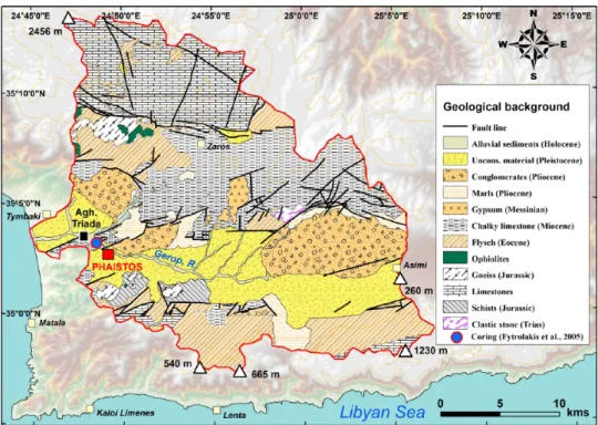
The island of Crete, in the Eastern Mediterranean (Figure 1), is well known for hosting one of the most famous ancient civiliza-tions, of the Minoans, who occupied the island from ca. 3000 to 1070 BC (Lefevre-Novaro et al., 2015; Marangou, 1992). The most prosperous cultural phase occurred from ca. 1900 BC until ca. 1450 BC (the proto- and neo-palatial periods), and as a reflec-tion of the great political and economic power of the civilizareflec-tion, numerous palaces were built close to the sea, such as Knossos, Malia, Kato Zakros, Aghia Triada, Mochlos and Phaistos (Figure 1). Although the chronology and occupation history of the Minoan sites are relatively well documented (Watrous et al., 1993), the landscape configuration around palatial sites is unclear (Rackham and Moody, 1996) and few studies (Lespez et al., 2001, 2003; Roberts, 1979; Siart et al., 2010; Theodorakopoulou et al., 2009) have focused on the palaeogeographic reconstruction of the sur-rounding landscape. Until now, the Cretan landscape configura-tion during various archaeological periods was unclear, especially in Minoan times (Rackham and Moody, 1996). The Messara Plain, in south central Crete, hosts several major archaeological sites dating from Minoan times. Among them, Aghia Triada and Phaistos are the most famous palatial sites (La Rosa, 1992a, 1992b) that may have been established on a paleoshoreline during Early Minoan times, according to a geological hypothesis (Fytro-lakis et al., 2005); however, archaeologists claim that during Minoan times, neither Phaistos nor Aghia Triada were coastal sites (Bintliff, 1977; La Rosa, 1992a, 1992b; Shaw and Shaw, 1995) and Kommos, or Matala, probably served as Phaistos’ har-bour (La Rosa, 1992b). This study aims to reconstruct the pal-aeoenvironmental context and landscape evolution around ancient Phaistos, former capital of the Minoan Kingdom, and specifically to determine whether its original location was on the shoreline of Tymbaki Gulf during Minoan times.
Geological, geomorphological and
hydrological setting
The Messara Plain (ca. 362 km2; Watrous et al., 1993) is an
east–west oriented tectonic graben (Fassoulas, 2001). It is
drained by the Geropotamos River and its tributaries (Figure 1; Fytrolakis et al., 2005). There is no permanent river or stream flow today. To the north, it is bounded by the Ida mountains (Mount Psiloritis, 2456 m a.s.l.; Figure 1) and to the south by the Asteroussia Hills (ca. 1230 m a.s.l.; Figure 1). To the west, near Ancient Phaistos, the narrow and incised Geropotamos River connects the Messara Plain to the Tymbaki coastal plain and the surrounding Tymbaki Gulf (Libyan Sea), where other Minoan sites, such as Kommos and Aghia Triada, are located (Figure 1). Several tributaries of the Geropotamos River mainly drain Ida Mountains, especially the Koutsoulidi and Mageros streams (Figure 1). To the east, the Geropotamos catchment (ca. 600 km2) is separated from the Anapodaris catchment by a very
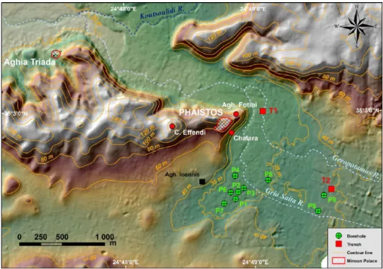
smooth hilly range at 260 m above mean sea level (amsl) (Fig-ure 1). The geological setting of the area is described in detail by Peterek and Schwarze (2002, 2004) and Fytrolakis et al. (2005). The geology comprises Cretaceous (to the south) and Jurassic (to the north) limestones, and locally Mesozoic dolo-mites, Jurassic schists and ophiolites. Terrestrial and marine deposits of Miocene–Pliocene age occur at the western end of the Messara Plain (marls, clays and sandstones; Figure 2). Fly-sch and Pleistocene continental deposits occur to the south. The Messara Plain consists of a thick accumulation of detrital mate-rial that formed during the Pleistocene and Holocene (Figure 2). Seismic and neotectonic activity is evident in the study area (Tsapanos, 2001), as well as land subsidence (Papadaki, 2014; Peterek and Schwarze, 2004). Multiple active fault lines inter-sect the plain as well as the shoreline on the west (Figure 2); among them the Aghia Triada, Vori and Mires active faults, responsible for vertical movements in the Late Pleistocene to Holocene (Peterek and Schwarze, 2004), occur around Phaistos (which is developed on a horst). Kelletat and Zimmermann (1991) pointed to a southward tilting of the area during histori-cal times, with a subsidence of around 2–3 m by Minoan, and around 1.2 m by Roman times (Mourtzas and Marinos, 1994). This tectonic activity shaped the local landscape and resulted in significant changes during the Holocene. The Holocene evolu-tion of the coastal plain of Tymbaki was studied in the mid-2000s via the drilling of deep boreholes near Phaistos– Aghia Triada (Fytrolakis et al., 2005; Figure 2). However, the
Figure 1. Location map of the study area and of the drainage basin of the Geropotamos River (red line). Black dashed-line: drainage basin of
chronostratigraphy of the borehole drilled near Aghia Triada– Phaistos (Figure 2) remains unclear because of the lack of robust age control of the different facies that are not precisely identified. Mollusk assemblages are a promising chronological approach since a layer of marine shells has been identified at the depths of ca. 22–28 m below the surface (0/+6 m amsl), but it has not been radiocarbon dated. Despite the lack of age con-trol, a possible marine incursion during Neolithic and Early Minoan Times was inferred by Fytrolakis et al. (2005). How-ever, further coring is needed to elucidate the Mid- to Late Holocene chronostratigraphy in the surroundings of Phaistos.
Past climate and related alluvial
evolution in Crete in the second
half of the Holocene
The Aegean Sea is an important climatic transition area for the entire Eastern Mediterranean (Zervakis et al., 2004) and is par-ticularly sensitive to climatic forcing, both at present (Roether et al., 1996; Theocharis et al., 1999; Zervakis et al., 2000) and in the past (Kuhnt et al., 2007; Marino et al., 2007). The Aegean Sea is distant and partially isolated from the North Atlantic oce-anic circulation (Xoplaki, 2002). It is under the influence of multiple climate forcings, including the Siberian High (the extent of the polar vortex) and sub-tropical/tropical systems (Casford et al., 2003; Gogou et al., 2007; Macklin et al., 2010; Marino, 2008; Rohling et al., 2002). Although compared with the Last Glacial period, the amplitude of Mid- to Late-Holo-cene climate fluctuations was less pronounced, the eastern Mediterranean climate was less stable during this interval than previously thought (Kaniewski et al., 2013). For the last 5 kyr, climate reconstruction in South-Central and Eastern Crete is based mainly on past fluvial dynamics where phases of incision and aggradation, related to specific climatic conditions, were identified (Maas and Macklin, 2002; Macklin et al., 2010; Moody, 2000; Theodorakopoulou et al., 2009, 2012, 2017). In the nearby catchment of the Anapodaris River (East of Messara Plain; Figure 1), Macklin et al. (2010) recorded two major phases of coarse-grained aggradation dated to 4.86–4.2 and
3.4–3 cal. kyr BP; while in the Xeropotamos catchment (East-ern Crete), a phase of thick alluvial sediment accretion occurred from ca. 4.95 ± 0.3 cal. kyr BP (Theodorakopoulou and Bassia-kos, 2017). Both pieces of work suggest that regional climatic cooling climate and episodes of heavy rainfall occurred from ca. 5.0 to 3.0 cal. kyr BP. The interval from 3.4 to 3.0 cal. kyr BP in Crete was especially humid (Macklin et al., 2010), and similar observations have been made throughout Mediterranean for the same period (Macklin et al., 2006; Zielhofer et al., 2008). Based on a study of Minoan flood deposits, Moody (2000) proposed a ‘Minoan Little Ice Age’ between 2000 and 1250 BC, possibly dominated by intense floods, and reinforc-ing the idea of a wet phase durreinforc-ing the period from 5 to 3 cal. kyr BP. Moreover, the period following the so-called ‘4.2 ka event’ (Zanchetta et al., 2016 and references therein) was character-ized by mild conditions in Crete, with the onset of a rapid cli-mate change (RCC) in the middle of the second millennium BC (Mayewski et al., 2004). This last period in the Aegean is attrib-uted to the synchronous deflection or weakening of the major global monsoon and ocean-atmosphere circulation systems (Weiss, 2016). Focusing on the period of Minoan demise, Tso-nis et al. (2010) determined that a strengthening of El Nino events began at about 1450 BC, making it highly probable that the area of Crete started to experience drier conditions from 1450 to 1200 BC. Although there are age discrepancies between proposed Holocene regional climate events, the study of Kaniewski et al. (2013) clearly identified that the Late Bronze Age crisis in Cyprus and Syria coincided with the onset of a 300-year drought cycle around 1200 cal. BC. Still in the Eastern Mediterranean, and at the same time, the fall of Mycenae is also ascribed to a climatic cause (Bryson et al., 1974; Carpenter, 1966; Weiss, 1982). Following the Late 2nd millennium BC climate aridification, Macklin et al. (2010) doc-umented phases of incision and finegrained sediment accumu-lation in the Anapodaris catchment after 3 cal. kyr BP, which continued until ca. 2 cal. kyr BP, and suggested the occurrence of warmer and drier climatic conditions during the first millen-nium BC. Clearly, focused local investigations are needed to correlate small-scale climatic fluctuations and their possible impacts on human societies.
Figure 2. Geological map of the Geropotamos River. Data are from IGME maps (1: 50,000) and based on Peterek and Schwarze (2004) and
1228 The Holocene 28(8)
Human occupation of the
western Messara Plain and the
archaeological setting of Phaistos
Of the many settlements in Crete, Phaistos is one of the most important and long-lived. It is best known for the court-centred building – called a ‘Palace’ in the literature – erected at the begin-ning of the second millennium BC. Although the site had a longer occupation time, its vestiges are still largely unexplored. The ear-liest evidence of human occupation in the Phaistos area probably dates to the Late Neolithic period (4000–3500 BC; Di Tonto, 2009; Mentesana et al., 2016; Todaro and Di Tonto, 2008; Watrous et al., 2004). A recent re-examination of these earlier stages in the life of the site has revealed several phases of occupation from the Final Neolithic (Todaro, 2013), which continued until the first phase of Minoan civilization, better known as Pre-palatial (ca. 2700–2200 BC). The latter was a phase of major growth, espe-cially of agriculture; at Aghia Triada, the processing of olives and grain are documented by grindstones and storage pithoi (Watrous et al., 2004).
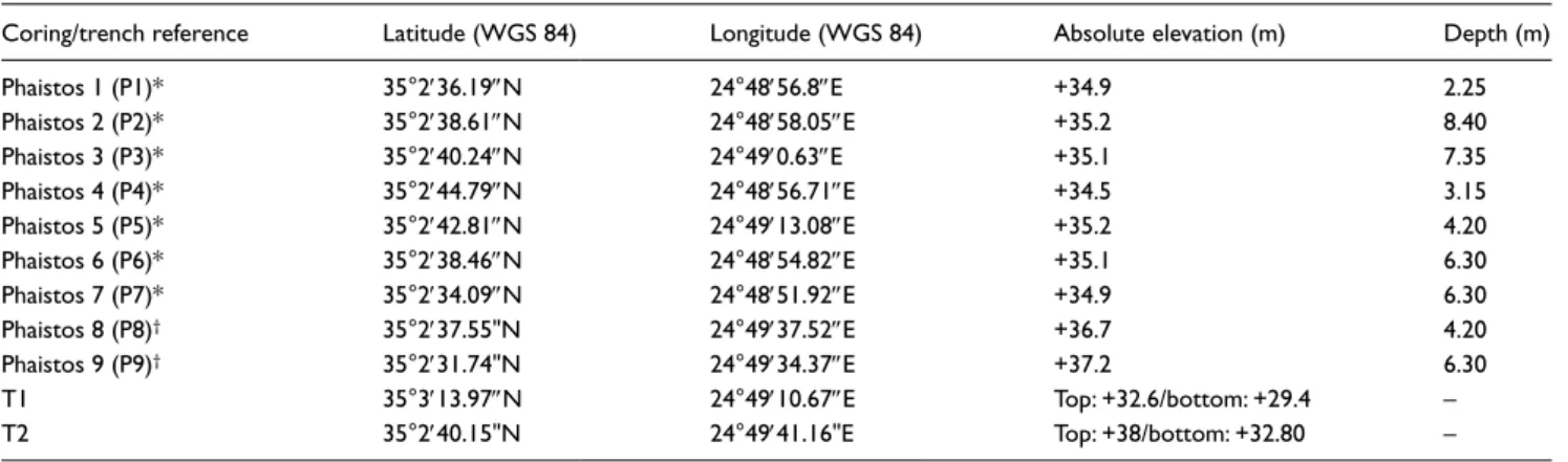
A recent survey (Bredaki and Longo, 2009) has yielded new evidence suggesting that the ‘urban’ area of the Protopala-tial Phaistos extended southward from the hilly range to the village of Aghios Ioannis and the hill of Christos Effendi to the west (see Figure 3 for locations). The archaeological evidence thus documents the existence of a vast settlement in this area, which was about as extensive as the later Hellenistic city (Bre-daki and Longo, in press; Bre(Bre-daki et al., 2012; Watrous et al., 2004).
In subsequent periods, the settlement contracted significantly, especially during the phases that followed the fall of the first pal-aces (ca. 1800–1450 BC), and again in the Mycenaean period (ca. 1450–1200 BC). This decline in size was probably related to the concomitant rise of the site of Aghia Triada, which from ca. 1600 to 1500 BC onwards was a powerful political centre with strong ties to the Neo-palatial and Post-palatial elites of Knossos (La Rosa, 1985, 2010). The settlement in the Phaistos area also appears to have shrunk significantly around 1220–1100 BC and during the Sub-Minoan, Proto-Geometric and Geometric periods
(from ca. 1070 to 700 BC). At the time, it was very probably laid out in scattered housing groups, mostly on hilltops which facili-tated control of the resources of the plain (Longo, 2015a, 2015b). Near the future city, Proto-Geometric and Geometric phases (10th to 8th centuries BC) have been recognized on the hill of Christos Effendi, on the Palace hill, and along the eastern slopes (Chalara; Figure 3). The area of Aghia Photini, on the northern slopes of the Palace hill (Figure 3) – once occupied by Pre-, Proto- and Neo-palatial buildings – yielded burials dating mainly to the Proto-Geometric and Proto-Geometric periods (Longo, 2015a, 2015b; Rocchetti, 1967–1968, 1969–1970).
The archaic and classical phases of Phaistos are still poorly documented, apart from the materials unearthed near the Palace and from the settlement of Chalara located downhill. The epi-graphic documentation (collected in Bredaki et al., 2009; Mar-ginesu, in press) and the numismatic evidence (Carbone, 2017, in press) bear witness, in any case, to the presence of a flourishing community. The city limits in the Hellenistic period can be deduced from the remains of perimeter walls – some already in plain sight, others excavated – northwest of Aghios Ioannis, on the hill of Christos Effendi, and at Chalara, and by the distribution of burial grounds (Longo 2015a, 2015b, in press; Rocchetti, 1967–1968, 1969–1970). After the destruction in about 150 BC (La Rosa, 1990) and a period of abandonment, the hills and the plateau were resettled (2nd to 4th centuries AD), as is confirmed by a survey (Bredaki and Longo, in press; Rossi, in press).
For the earliest historical phases, the issues of coastline con-figuration and distance from the sea remain unclear – although these factors are believed to have played a decisive role in the choice of the location for the settlement (as is also the case for other centres on the island, such as Malia).
Methods
Coring and trench sampling
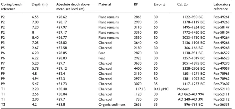
Nine 50-mm-diameter vibracores were drilled in October 2011 and May 2014, in the lowlands of Ancient Phaistos, up to a maxi-mum depth of 8.40 m below the surface (Table 1 and Figure 3). In addition, two stratigraphic sections (T1 and T2; Table 1 and
Figure 3) were studied and sampled for laboratory analyses. Each borehole and both trenches were precisely levelled with Differen-tial Global Positioning System Trimble R8 equipment.
Magnetic susceptibility measurements and grain-size analy-sis. Sediment cores P2, P5 and P7 were selected for the heteroge-neity of their sediments and were sampled at 5 cm resolution, except for levels which included reworked material. Magnetic susceptibility measurements were made using an MFK1 magnetic susceptibility metre (Agico) at CEREGE (Aix en Provence, France), at frequencies of 976 Hz and 15616 Hz. The values were divided by the density of the dried samples to obtain mass-spe-cific susceptibilities (χ). χ values reflect the contributions of dia-magnetic, paradia-magnetic, ferromagnetic and imperfect antiferromagnetic particles (Dearing et al., 1996), but high values typically reflect the concentration of ferromagnetic particles.
The grain-size distribution of the fine fraction (<2 mm) was measured by laser diffraction granulometry at CEREGE. Samples were taken at 5 cm intervals. All samples were first heated to 450°C and mixed with a dispersing agent (0.3% sodium hexam-etaphosphate) to disaggregate the clay particles. For the calcula-tion model, we used water as the medium (refractive index (RI) = 1.33 at 20°C), a RI in the range of that of kaolinite for the solid phase (RI = 1.56), and absorption coefficients of 0.15 for the 780 nm laser wavelength and 0.2 for the polarized wavelengths (Buurman et al., 1996, 1997).
Loss-on-ignition and carbonate (CaCO3) content. Loss-on-ignition
(LOI) measurements were made at CEREGE, following Dean (1974) and Bengtsson and Enell (1986). Sediment samples of approximately 1 g were taken at 10 cm intervals throughout the sequence. After drying at 105°C to constant weight, the samples were heated to 550°C for 7 h to estimate the organic content. A second heating phase, to 950°C for a further 7 h, was undertaken to assess the proportion of carbonate.
Diatom and pollen analyses. Diatom analyses were conducted on
all cores but only core P2 (the interval from 6.80 and 6.50 m, five samples in total) contained enough material for analysis. Sedi-ment (clay) of 0–5 g was treated using standard procedures (1:1 mixture of H2O2/water, 1:1 mixture of HCl/water), and repeated
rinsing in distilled water (see Battarbee et al., 2001 for details). For each sample, at least 400 diatom valves were identified and counted using a light microscope (×1000 magnification). Speci-mens were identified following the species concept of Krammer and Lange-Bertalot (1986, 1988, 1991a, 1991b). However, many of the genera and species outlined therein have been re-assessed using the classification of Round et al. (1990) and synonyms are
used here. Diatom concentrations were calculated using the dry weight of the sample.
Pollen analyses were conducted on cores P2, P3 and P6, which contained fine-grained material (stiff clays) that could potentially yield pollen; however, only core P2 had a sufficient pollen con-centration and in which bioindicators were well preserved. Sam-pling was conducted every 5 cm for the depth interval from 8.30 to 5.25 m; only the interval from 7 to 5.80 m contained sufficient pollen grains for analysis. For the samples from this interval, at least 300 pollen grains, excluding aquatics, were counted. In total, 23 samples were analysed (samples at the depth of 6.85 m and 6.95 m were excluded because of poor preservation and scarcity of pollen grains). Chemical pre-treatment of the samples followed Nakagawa et al. (1998) and identifications were made ×500 mag-nification using the pollen reference collection of the IMBE Lab-oratory (Aix-en-Provence, France) and pollen photographic atlases (Beug, 2004; Reille, 1992, 1995, 1998). Charcoal mic-roparticles (size >20 μm) were also counted.
AMS 14C dating. The chronostratigraphy of the cores and trenches
was established using a series of 18 AMS radiocarbon determina-tions from charcoal, organic matter, plant remains and peat sam-ples (Table 2). The analyses were made in the Poznan (Poland) Radiocarbon Dating Laboratory. 14C ages were calibrated using
Calib Software Version 7.1 (Stuiver and Reimer, 1993) and the IntCal13 calibration curve (Reimer et al., 2013). In addition, a smoothing spline age-depth model (Figure 4) was constructed for core P2 (where the pollen analyses were conducted) for the inter-val from 8.40 to 5.80 m, using R software and the Clam package (Blaauw, 2010). Given the homogeneous texture of the sediments (fine clays), extrapolation of the depth age model for the interval from 6.55 to 5.80 m deep is regarded as reliable.
Electric resistivity tomography
The geometry and location of the main sub-surface structures were analysed using electric resistivity tomography (ERT). A computer-inversion programme (Res2Dinv; Loke, 2003) includ-ing the topography generates images of resistivity distribution along a cross-section below the survey line. ERT has been suc-cessfully used in various sub-surface field studies, especially in geomorphology (Beauvais et al., 2007; Ghilardi et al., 2017) and archaeology (Ghilardi et al., 2015; Quesnel et al., 2011; Siart et al., 2010). In this study, a 2D-resistivity tomography was obtained using the ABEM Lund Imaging System (Terrameter LS/4channel) with an array of 64 electrodes with a Schlumberger– Wenner reciprocal layout protocol. In the Messara Plain, data acquisition was conducted from 21 to 23 June 2013. ERT profiles
Table 1. Borehole and trench information.
Coring/trench reference Latitude (WGS 84) Longitude (WGS 84) Absolute elevation (m) Depth (m) Phaistos 1 (P1)* 35°2′36.19″N 24°48′56.8″E +34.9 2.25 Phaistos 2 (P2)* 35°2′38.61″N 24°48′58.05″E +35.2 8.40 Phaistos 3 (P3)* 35°2′40.24″N 24°49′0.63″E +35.1 7.35 Phaistos 4 (P4)* 35°2′44.79″N 24°48′56.71″E +34.5 3.15 Phaistos 5 (P5)* 35°2′42.81″N 24°49′13.08″E +35.2 4.20 Phaistos 6 (P6)* 35°2′38.46″N 24°48′54.82″E +35.1 6.30 Phaistos 7 (P7)* 35°2′34.09″N 24°48′51.92″E +34.9 6.30 Phaistos 8 (P8)† 35°2′37.55"N 24°49′37.52″E +36.7 4.20 Phaistos 9 (P9)† 35°2′31.74"N 24°49′34.37″E +37.2 6.30
T1 35°3′13.97″N 24°49′10.67″E Top: +32.6/bottom: +29.4 – T2 35°2′40.15"N 24°49′41.16"E Top: +38/bottom: +32.80 – *Borehole drilled in October 2011.
1230 The Holocene 28(8)
were conducted with an electrode distance of 2, 3, 4 and 8 m. The length of each of the five profiles ranged from 128 to 514 m (Fig-ure 5). The ERT method, however, does not provide a unique interpretation, since different materials can have similar electrical properties. Consequently, the usefulness of the interpretation depends on a good knowledge of the local context and, preferably, should be validated with a geotechnical/coring investigation. It is common practice to correlate data derived from resistivity tomog-raphy (a non-destructive method) with the results of coring and sampling (Ghilardi et al., 2015, 2017).
Results
Borehole chronostratigraphy
Bedrock (chalky limestone) was only reached in core P1, at a depth of 2.25 m, below the modern swamp environment. For the other boreholes, based on bio-sedimentological analyses, six sedi-mentary units can be identified, described below.
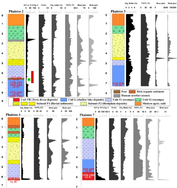
Unit TR was only found in the westernmost part of the plain,
in the lowermost part of core P7 (Figure 6, bottom right) and con-sists of reddish (lower part) to dark grey/reddish (upper part) silty clays with a mean grain-size generally from 10 to 40 μm. The total thickness is unknown and only 80 cm were collected in the sampler. Unit TR can be divided into two subunits. Subunit TR1
(6.30–5.90 m) consists of red clays. χ values are high, but they
decrease towards the top of the subunit: from 150 (6.30 m) to 50 × 10−8 m3/kg (5.90 m); χ
fd% values are constant and high, >10%,
indicating a significant contribution from superparamagnetic par-ticles. The carbonate content is <10%. The subunit is exclusively composed of terrigenous material (Terra Rossa). Subunit TR2
(5.90–5.50 m). This subunit overlies TR1. It consists of a mixture
of grey and red clays with relatively low χvalues (<50 × 10−8 m3/
kg) and with a carbonate content increasing from 10% (at the top of TR1) to ca. 45%. The transition from TR1 to TR2 is radiocar-bon dated to 3328–2906 BC (Table 2). Thus, the age of the Terra
Rossa deposits is from the late fourth Millennium BC.
Unit G was only found in the eastern part of the investigated
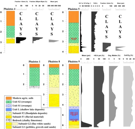
area, in cores P8 and P9 (Figure 7). Due to the paucity of organic matter, no radiocarbon dating was done on these coarse layers. Unit G can be divided in two subunits based on the grain-size.
Subunit G1 (from 4.25–3.00 m depth in core P8 and from 6.30– 6.00 m depth in core P9). It consists of cemented (carbonate
matrix), rounded pebbles (maximum size of 4 cm) and gravels, alternating with reddish (reflecting oxidation) medium- to coarse-grained sands. Subunit G2 overlaying subunit G1, is composed of homogeneous medium yellow sand; the thickness is about 0.45 m in both cores. Clearly, the sediments of subunits G1 and G2 are of terrigenous origin, deposited in an overall high energy environ-ment, but with phases of alternating low and high energy condi-tions. Despite the lack of radiocarbon dates, a pre-Holocene age can be inferred.
Unit L occurs in cores P2, P3, P6, P7 and P9 (Figures 6 and 7).
It consists of homogeneous grey silty clays with a mean grain-size from 4 to 50 μm; there are some intercalations of coarser material (generally fine sands) in the uppermost part of the unit. χ values are generally low (less than 50 × 10−8 m3/kg) and there is only one
peak in core P2, at a depth of 7.85 m, with a value of ca. 100 × 10−8 m3/kg. The carbonate content is generally high, fluctuating
between 20% and 40%, with an increase towards the top of the sequence. The organic matter content ranges from 2% to 6% and minor variations occur within the sequence. In the uppermost part
Table 2. Radiocarbon dating results.
Coring/trench reference
Depth (m) Absolute depth above mean sea level (m)
Material BP Error ± Cal. 2σ Laboratory reference P2 6.55 +28.62 Plant remains 2865 30 1122–930 BC Poz-49261 P2 7.00 +28.17 Plant remains 2990 35 1378–1119 BC Poz-49263 P2 7.20 +27.97 Plant remains 3110 50 1495–1264 BC Poz-58147 P2 8 +27.17 Plant remains 3310 80 1772–1420 BC Poz-58104 P2 8.40 +26.77 Plant remains 3550 50 2023–1750 BC Poz-49264 P3 7.05 +28.02 Charcoal 3640 40 2136–1906 BC Poz-49266 P5 2.67 +32.58 Charcoal 2180 30 366–166 BC Poz-49268 P6 6.20 +28.85 Peat 2870 30 1130–931 BC Poz-46522 P6 6.22 +28.83 Peat 2925 30 1257–1019 BC Poz-46523 P7 5.20 +29.7 Charcoal 3630 35 2051–1895 BC Poz-49270 P7 5.78 +29.12 Charcoal 4400 50 3328–2906 BC Poz-49059 P9 4.8 +32.4 Charcoal 3130 50 1501–1271 BC Poz-70961 P9 4.94 +32.3 Charcoal 2970 50 1381–1022 BC Poz-70962 P9 5.47 +31.73 Charcoal 3070 35 1417–1257 BC Poz-73607 T1 2.20 +30.40 Charcoal 117.13 0.42 pMC Modern Poz-52110 T1 2.56 +30.04 Charcoal 1120 30 AD 862–AD 994 Poz-52111 T1 2.90 +29.7 Charcoal 1730 30 AD 240–AD 391 Poz-52112 T2 4.2 +33.8 Organic sediment 2655 35 896–791 BC Poz-56331
Figure 4. Age-depth model for core P2 (from 8.40 to 5.80 m
depth) constructed using R software and the Clam package (Blaauw, 2010).
Figure 5. ERT profiles and borehole/trench locations.
Figure 6. Chronostratigraphy of cores P2, P3, P6 and P7. Magnetic susceptibility parameters (Xlf and Xfd%) are only reported for cores P2
and P7. Organic matter and carbonate content and granulometric indices (mean and mode) are reported for each core, plotted as a function of depth below the surface.
1232 The Holocene 28(8)
of the unit, in cores P2 and P6, there is a peat layer (organic matter content of ca. 10%), ca. 10 cm in thickness. Radiocarbon dating of the base of the peat layer in core P6 gave an age of ca. 1257– 1019 BC, while the uppermost part in cores P2 and P6 gave the younger age of ca. 1130–930 BC. In core P6, in the lowermost part of the peat deposit, at a depth of 6.35 m, the gastropods
Heli-copsis bathytera, Helicella sp. and Xerolenta obvia were
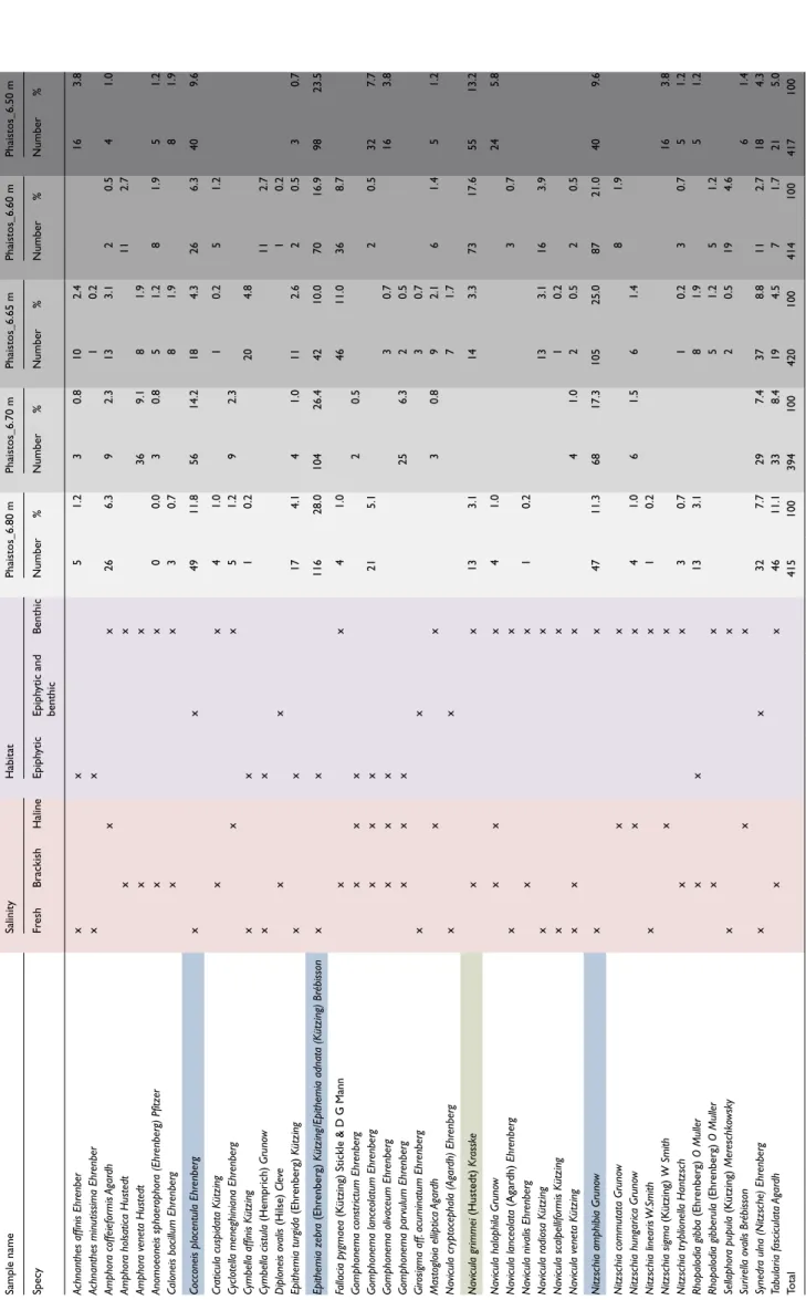
identi-fied, which are indicative of terrestrial environments, typically open meadows. Both the presence of the peat and the mollusk assemblage indicate that the water depth was probably decreas-ing. Clearly, Unit L is older than the age of the peat and this was confirmed by a series of 9 radiocarbon dates performed on plant remains and bulk organic matter. The lowermost part of Unit L was dated to 2024–1750 BC in core P2, and similar ages were obtained for core P3 (2136–1906 BC) and P7 (2051–1895 BC). However, the complete thickness of Unit L remains unknown and deeper coring near cores P2 and P6 would be needed in order to reveal the lowermost part of Unit L. Bioindicators are sparse in Unit L; however, freshwater gastropods, mainly Planorbia sp., are present. Diatom analysis (Table 3 and Figure 8(a) and (b)) of the uppermost part of core P2 (from 6.8 to 6.5 m depth), indicated a range of freshwater species (50–65% of the identified species where Epithemia adnata, Cocconeis placentula, Nitzschia
amphibia and Synedra ulna are the most encountered species) and
brackish-water species (25–42% of the identified species where
Navicula grimmei, Fallacia pygmaea and Tabularia fasciculata
are the most encountered species). Benthic diatoms were the most
commonly encountered types within the peat sequence, while a similar amount of benthic and epiphytic diatoms was found within the top of the Unit L (Figure 8(b)). The representation of freshwa-ter species decreases towards the top of Unit L. Haline species of diatoms were also found but with a very low representation (<5%); some authors attribute such a low representation to the presence of migratory birds, which may have come from the nearby sea (in the case of the Messara Plain, Tymbaki Gulf is just 5 km to the west). The diatom results also reveal a gradual increase in brackish-water species towards the peat layer, while at the same time, the freshwater species decrease, indicating a shal-lowing of the water depth which was probably caused by increased evaporation. Overall, the diatom assemblages indicate the exis-tence of a shallow oligohaline environment during at least Late Minoan times.
Unit S1 occurs above unit L in cores P2, P3, P6, P7 (in the
westernmost part of the Messara Plain, in the Phaistos lowlands; Figure 6) and in core P9 (easternmost part of the study area; Figure 7). S1 is well represented in cores P2 and P6 where it overlays the peat layer. Its thickness is greater in cores P2, P3 and P6 (ca. 1.20 m) than in core P7 (<0.50 m) and P9 (0.30 m). The sediments are generally richer in organic matter than in Unit L, with values fluc-tuating between 4% and 6%, while the carbonate content is around 20% (roughly one-half of the carbonate content of Unit L). The χ values are generally very low (ca. 10 × 10−8 m3/kg). Bioindicators
are scarce, but among them, mollusks found embedded within the sediments are typically from freshwater (swamp) environments.
Figure 7. Chronostratigaphy of cores P1, P4, P5, P8 and P9. Magnetic susceptibility parameters (Xlf and Xfd%) are only reported for core
P5, while organic matter and carbonate contents and granulometric indexes (mean and mode) are reported for cores P5 and P9, plotted as a function of depth below the surface. For cores P4 and P5, the fractions <2 mm and >2 mm are shown; the mean grain-size was determined solely for the fraction <2 mm.
Ghilardi et al. 9 Tab le 3. Diatom r esults obtained f or cor e P2 at the depths of 6. 50, 6.60, 6.70 and 6.80 m. Sample name Salinity Habitat Phaistos_6.80 m Phaistos_6.70 m Phaistos_6.65 m Phaistos_6.60 m Phaistos_6.50 m Specy Fr esh Brackish Haline Epiph ytic Epiph ytic and benthic Benthic Number % Number % Number % Number % Number % Ac hnanthes aff inis Ehr enber x x 5 1.2 3 0.8 10 2.4 16 3.8 Ac
hnanthes minutissima Ehr
enber x x 1 0.2 Amphor a coff eief ormis Agar dh x x 26 6.3 9 2.3 13 3.1 2 0.5 4 1.0 Amphor a holsatica Hustedt x x 11 2.7 Amphor a veneta Hustedt x x 36 9.1 8 1.9 Anomoeoneis sphaer ophor a (Ehr enberg) Pf itz er x x 0 0.0 3 0.8 5 1.2 8 1.9 5 1.2
Caloneis bacillum Ehr
enberg x x 3 0.7 8 1.9 8 1.9
Cocconeis placentula Ehr
enberg x x 49 11.8 56 14.2 18 4.3 26 6.3 40 9.6 Cr aticula cuspidata K ützing x x 4 1.0 1 0.2 5 1.2 Cyc
lotella meneghiniana Ehr
enberg x x 5 1.2 9 2.3 Cymbella aff inis K ützing x x 1 0.2 20 4.8 Cymbella cistula (Hemprich) Gruno w x x 11 2.7 Diploneis o valis (Hilse) Cle ve x x 1 0.2 Epithemia turgida (Ehr enberg) Kützing x x 17 4.1 4 1.0 11 2.6 2 0.5 3 0.7 Epithemia z ebr a (Ehr enberg) Kützing/Epithemia adnata (K ützing) Br ébisson x x 116 28.0 104 26.4 42 10.0 70 16.9 98 23.5 Fallacia p ygmaea (K
ützing) Stickle & D G Mann
x x 4 1.0 46 11.0 36 8.7 Gomphonema constr ictum Ehr enberg x x x 2 0.5
Gomphonema lanceolatum Ehr
enberg x x x 21 5.1 2 0.5 32 7.7
Gomphonema olivaceum Ehr
enberg x x x 3 0.7 16 3.8 Gomphonema par vulum Ehr enberg x x x 25 6.3 2 0.5 Gir osigma aff. acuminatum Ehr enberg x x 3 0.7 Masto gloia elliptica Agar dh x x 3 0.8 9 2.1 6 1.4 5 1.2 Navicula cr yptocephala (Agar dh) Ehr enberg x x 7 1.7 Navicula gr immei (Hustedt) Kr assk e x x 13 3.1 14 3.3 73 17.6 55 13.2
Navicula halophila Gruno
w x x x 4 1.0 24 5.8 Navicula lanceolata (Agar dh) Ehr enberg x x 3 0.7
Navicula nivalis Ehr
enberg x x 1 0.2 Navicula r adiosa K ützing x x 13 3.1 16 3.9 Navicula scalpellif ormis K ützing x x 1 0.2 Navicula veneta K ützing x x x 4 1.0 2 0.5 2 0.5 Nitzsc
hia amphibia Gruno
w x x 47 11.3 68 17.3 105 25.0 87 21.0 40 9.6 Nitzsc hia comm utata Gruno w x x 8 1.9 Nitzsc hia hungar ica Gruno w x x 4 1.0 6 1.5 6 1.4 Nitzsc hia linear is W .Smith x x 1 0.2 Nitzsc hia sigma (K ützing) W Smith x x 16 3.8 Nitzsc hia tr yblionella Hantzsc h x x 3 0.7 1 0.2 3 0.7 5 1.2 Rhopalodia gibba (Ehr enberg) O Muller x x 13 3.1 8 1.9 5 1.2 Rhopalodia gibberula (Ehr enberg) O Muller x x 5 1.2 5 1.2 Sellaphor a pupula (K ützing) Mer esc hk owsk y x x 2 0.5 19 4.6 Sur irella o valis Br ébisson x x 6 1.4 Synedr a ulna (Nitzsc he) Ehr enberg x x 32 7.7 29 7.4 37 8.8 11 2.7 18 4.3 Tabular ia fasciculata Agar dh x x 46 11.1 33 8.4 19 4.5 7 1.7 21 5.0 Total 415 100 394 100 420 100 414 100 417 100 The most r epr esented species ar e highlighted in blue (fr eshwater en vir onments) and in gr een (brackish en vir onments).
Tab le 3. Diatom r esults obtained f or cor e P2 at the depths of 6. 50, 6.60, 6.70 and 6.80 m. Sample name Salinity Habitat Phaistos_6.80 m Phaistos_6.70 m Phaistos_6.65 m Phaistos_6.60 m Phaistos_6.50 m Specy Fr esh Brackish Haline Epiph ytic Epiph ytic and benthic Benthic Number % Number % Number % Number % Number % Ac hnanthes aff inis Ehr enber x x 5 1.2 3 0.8 10 2.4 16 3.8 Ac
hnanthes minutissima Ehr
enber x x 1 0.2 Amphor a coff eief ormis Agar dh x x 26 6.3 9 2.3 13 3.1 2 0.5 4 1.0 Amphor a holsatica Hustedt x x 11 2.7 Amphor a veneta Hustedt x x 36 9.1 8 1.9 Anomoeoneis sphaer ophor a (Ehr enberg) Pf itz er x x 0 0.0 3 0.8 5 1.2 8 1.9 5 1.2
Caloneis bacillum Ehr
enberg x x 3 0.7 8 1.9 8 1.9
Cocconeis placentula Ehr
enberg x x 49 11.8 56 14.2 18 4.3 26 6.3 40 9.6 Cr aticula cuspidata K ützing x x 4 1.0 1 0.2 5 1.2 Cyc
lotella meneghiniana Ehr
enberg x x 5 1.2 9 2.3 Cymbella aff inis K ützing x x 1 0.2 20 4.8 Cymbella cistula (Hemprich) Gruno w x x 11 2.7 Diploneis o valis (Hilse) Cle ve x x 1 0.2 Epithemia turgida (Ehr enberg) Kützing x x 17 4.1 4 1.0 11 2.6 2 0.5 3 0.7 Epithemia z ebr a (Ehr enberg) Kützing/Epithemia adnata (K ützing) Br ébisson x x 116 28.0 104 26.4 42 10.0 70 16.9 98 23.5 Fallacia p ygmaea (K
ützing) Stickle & D G Mann
x x 4 1.0 46 11.0 36 8.7 Gomphonema constr ictum Ehr enberg x x x 2 0.5
Gomphonema lanceolatum Ehr
enberg x x x 21 5.1 2 0.5 32 7.7
Gomphonema olivaceum Ehr
enberg x x x 3 0.7 16 3.8 Gomphonema par vulum Ehr enberg x x x 25 6.3 2 0.5 Gir osigma aff. acuminatum Ehr enberg x x 3 0.7 Masto gloia elliptica Agar dh x x 3 0.8 9 2.1 6 1.4 5 1.2 Navicula cr yptocephala (Agar dh) Ehr enberg x x 7 1.7 Navicula gr immei (Hustedt) Kr assk e x x 13 3.1 14 3.3 73 17.6 55 13.2
Navicula halophila Gruno
w x x x 4 1.0 24 5.8 Navicula lanceolata (Agar dh) Ehr enberg x x 3 0.7
Navicula nivalis Ehr
enberg x x 1 0.2 Navicula r adiosa K ützing x x 13 3.1 16 3.9 Navicula scalpellif ormis K ützing x x 1 0.2 Navicula veneta K ützing x x x 4 1.0 2 0.5 2 0.5 Nitzsc
hia amphibia Gruno
w x x 47 11.3 68 17.3 105 25.0 87 21.0 40 9.6 Nitzsc hia comm utata Gruno w x x 8 1.9 Nitzsc hia hungar ica Gruno w x x 4 1.0 6 1.5 6 1.4 Nitzsc hia linear is W .Smith x x 1 0.2 Nitzsc hia sigma (K ützing) W Smith x x 16 3.8 Nitzsc hia tr yblionella Hantzsc h x x 3 0.7 1 0.2 3 0.7 5 1.2 Rhopalodia gibba (Ehr enberg) O Muller x x 13 3.1 8 1.9 5 1.2 Rhopalodia gibberula (Ehr enberg) O Muller x x 5 1.2 5 1.2 Sellaphor a pupula (K ützing) Mer esc hk owsk y x x 2 0.5 19 4.6 Sur irella o valis Br ébisson x x 6 1.4 Synedr a ulna (Nitzsc he) Ehr enberg x x 32 7.7 29 7.4 37 8.8 11 2.7 18 4.3 Tabular ia fasciculata Agar dh x x 46 11.1 33 8.4 19 4.5 7 1.7 21 5.0 Total 415 100 394 100 420 100 414 100 417 100 The most r epr esented species ar e highlighted in blue (fr eshwater en vir onments) and in gr een (brackish en vir onments).
1234 The Holocene 28(8)
Gastropods were recognized in core P2: at the depth of 6.07 m, a complete specimen of Oxyloma elegans was found, which is indic-ative of waterlogged conditions, typically living in reeds. Pollen was only found in core P2, from 7 to 5.80 m depth. No radiocarbon dates were obtained for the final stages of Unit S1, but an age of ca. 700 BC can be inferred from the age-depth model for core P2 (Figure 4). Unit S1 is typical of calm environments such as swamps and was deposited from ca. the 11th to the 8th–7th centuries BC. Thus, it is clear that following Minoan Times, a wetland persisted until Ancient Greek times (Archaic period).
Unit F, overlaying unit S1, is found in all cores except P7. It
consists of yellowish fine sands to rounded gravels. The thickness of the unit is about 2 m in P9 while in cores P2, P3 and P6 it con-sists of only 20–40 cm of fine to coarse sands. In cores P4 and P5, a complete thickness was not recovered since a compacted layer of rounded pebbles and gravels prevented deeper drilling. Cores P4, P5 and P9 record the coarsest deposits, while cores P2, P3, P6 and P7 are less influenced by these fluvial sediments. Two sub-units are recognized. The sediments of Subunit F1 were deposited in a high energy environment, which was succeeded in Subunit F2 by the deposition of floodplain deposits. χ values are generally low in core P2, ca. 20 × 10−8 m3/kg. However, in core P5 core they
are higher and fluctuate within the range of 20–100 × 10−8 m3/kg,
which may reflect the input of reworked material from the catch-ment, in particular from the Asteroussia Mountains where meta-morphic rocks, such as gneiss and schists, have a significant magnetic mineral content (Figure 2). Dating Unit F was difficult because of the absence of organic material and thus the age of this fluvial event is difficult to determine accurately; however, it appears to have been a brief episode of alluviation. Based on the radiocarbon dating of core P5 core, and the dated alluvial sequence in both trenches, it is possible that Unit F dates from ca. the 7th to the 5th centuries BC. Clearly, a paleo river existed during the first phases of ancient Greek times; it may have been the modern Gria Saita River (Figure 3) but is also possible it was a former channel of the Geropotamos River, which today flows further north.
Unit S2, above Unit F, a second phase of swamp development can be inferred from all cores. Unit S2 consists of dark grey clays and silts with intercalated peat layers, such as in core P6. The lowermost part of this unit was only dated in core P5, which gave an age of 366–166 BC. (Hellenistic period), while it appears that the uppermost of the unit (close to the surface) is recent (19th to 20th centuries AD).
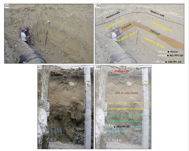
Chronostratigraphy from the trenches
Trench T1 (lower Phaistos area): Floodplain dynamics. During
autumn 2012, a ca. 2 m deep trench was excavated (Table 1; Figure 9(a) and (b)) and sampled for grain-size analyses and radiocarbon dating. It is located at the foothill of the Phaistos site (150 m to the east; Figure 3), at a short distance (less than 20 m)
from the present-day main course of the Geropotamos River (dry at that time of the year). Three sedimentary units were identified (Figure 9(a) and (b)) which all reflect the dynamics of terrigenous deposition. Two main phases of low-energy floodplain deposition (yellowish to brownish clays to fine sands) are separated by an intercalated horizon of organic clays. The base of the floodplain sequence is dated to AD 240–AD 391 AD while the uppermost floodplain level is dated to the 20th century AD and forms the modern agricultural soils. Numerous rounded orange pottery sherds were found embedded within the lowermost floodplain layer, indicating a reworked origin. All the results indicate that the Geropotamos River, or one of its former courses, flowed through the area, at least from Late Roman times.
T2 trench (easternmost part of the study area): From limnic to
floodplain environments. A second trench was excavated in Spring
2013, to the northeast of cores P8 and P9 (Figure 3). The total thickness of the deposits is about 5.2 m and four main sedimen-tary units are recognized (Figure 9(c) and (d)). In the lowermost part of T2, dark grey clays occur with similar features to the lim-nic clays in Unit L, sampled in the lowermost parts of cores P2, P3, P6, P7 and P9. Radiocarbon dating of bulk organic matter from the upper part of these limnic clays gave an age of 896–791 BC and indicates that the area was still a wetland that dried up during Geometric times. Overlying this limnic unit are a sequence of dark to light grey clays and yellowish silts and sands (ca. 50 cm thick), clearly revealing the occurrence of swamp environments (similar to S1 unit). The third sedimentary unit consists of brown-ish silts to coarse sands and reveals alluvial dynamics, probably the fluvial deposits that are also present in cores P2, P3, P4, P5, P6 and P9. The fourth unit is found 0.30 cm below the modern agricultural soils and consists of organic clays (thickness of about 20 cm). The sedimentary parameters reveal features resembling those of the intercalated organic layer observed in trench T1 that dates to the 19th to 20th centuries AD. In general, the stratigraphy of trench T2 is very similar to that of core P9 (Figure 7, bottom right) in its lower part, and it exhibits similar features to trench T1 in its upper part. Trench T2 provides evidence for the spatial extent of paleolimnic environments eastwards and confirms the
14C dating results for the last stages of the limnic phase, probably
around the first third of the first millennium BC.
Pollen results
The pollen results for core P2 reveal vegetation changes from ca. 1250 to 700 BC in the vicinity of Ancient Phaistos (Figure 10). Pollen assemblages evidence an open cultural Mediterranean landscape with a sparse tree cover (Arboreal Pollen (AP) <10%) and a high representation of herbaceous plants related to human activities (ruderal and cultivated plants). Three main local pollen
Figure 9. Stratigraphic sections T1 and T2 (a, c) with their paleoenvironmental interpretation and dating (b, d).
areas (LPAZ) were identified based on fluctuations in the pollen curves of ruderal, aquatic and hygrophilous plants: the ruderal assemblage testifies to the evolution of human activities (cultiva-tion and pastoralism) while the others reveal changes in the veg-etation composition of the wetland area.
LPAZ1 (700–655 cm, from ca. 1220 ± 71 to ca. 1035 BC,
Post-Palatial and Sub-Minoan periods) is characterized by high values of ruderals, Olea and aquatics (Ranunculus). In the sub-zone
LPAZ1a, there is an increase in Ranunculus values. In the sub-zone LPAZ1b, the percentages of Ranunculus decrease and,
concur-rently, there is an increase of the representation of helophytes (Sparganium and Alisma plantago) and arboreal taxa (Quercus sp. and Pinus brutia). There is a peak in charcoal particles around 1100–1050 BC, indicating a phase of uncontrolled fires during the Sub-Minoan period or the deliberate burning of human settlements during a period of social instability (Middleton, 2010, 2017).
In LPAZ2 (650–620 cm, from ca. 1035 to 875 BC, covering the second half of the Sub-Minoan period and the Proto-Geometric period), there is a decrease in ruderals and Olea, and Poaceae,
Sparganium and Alisma plantago reach a maximum.
In LPAZ3 (615–580 cm, from ca 875 to ca. 700 BC, roughly corresponding to the Geometric period), the values of ruderals and Olea increase again and the percentages of Sparganium and
Alisma plantago decrease sharply. At the top of the pollen record, Isoetes reaches a maximum. This latter species grows in
terres-trial rather than aquatic environments, on damp ground (Turland et al., 1993) and it also indicates summer dryness and a wet winter half-year (Bottema and Sarpaki, 2003).
In summary, the pollen data indicate that between the Late Minoan period and the early stages of the Archaic period, a fresh-water lake has existed as indicated by the high representation of
Ranunculus values (LPAZ1a) and became a swamp (after 1000
BC) when the water table declined, as revealed by the decrease in Ranunculus (LPAZ1b). The drying up of the lake led to the
disappearance of aquatic buttercup and to the extension of helo-phytic communities (LPAZ2), indicating the settlement of a swampland. The simultaneous peaks in Isoetes and of ruderals may reflect an environment disturbed by human activity, and the presence of Lemna, at the same time, could indicate a transitory rise in the water table shortly before ca. 700 BC. The intermittent representation of Alnus glutinosa and Tamarix indicate that an open riparian forest was established around the lake situated in the lowland of Phaistos. It is interesting to point out the absence of Juglans and Platanus, which today in Greece are frequently encountered in riverine communities. The dynamics of the aquatic and helophytic vegetation confirm the conclusions provided by the sedimentological and diatom analyses. The results generally indicate an open landscape (more so than at other Cretan sites such as Kournas or Chania; Moody et al. (1996) and Bottema and Sarpaki (2003)) along the sequence with very low AP representa-tion with the intermittent presence of Quercus and Pinus and a very high contribution of pollen from herbs and ruderals (~50– 80%). Thus, the results clearly reveal a Mediterranean man-made landscape and environment where trees, mainly Olea (domesti-cated), and herbs and ruderals were highly represented. Similar observations have been recently reported at Palaikastro (Eastern Crete) during Early Minoan times (Cañellas-Boltà et al., 2018).
ERT profiles and subsoil resistivity
The five ERT profiles measured in the western part of the study area (Figures 4 and 11) reveal the subsoil morphology. Three geo-electric units can be identified and are described below.
Unit Ge1. This unit occurs in all profiles, generally within the
first few metres. Low resistivity values (<35 Ω m) indicate high conductivity between the present-day surface and a maximum depth of ca. 10–15 m in profile ERT-5, where cores P2 and P6 are
1236 The Holocene 28(8)
located. The stratigraphy of the latter confirms that fine-grained sediments (mainly clays and fine sands) are associated with the low resistivity. In profile ERT-1, ERT-2 and ERT-4, Unit Ge1 only comprises the first 5 m of the profiles. In profile ERT-4, Unit Ge1 is only 2 to 3 m thick between 117 and 141 m. This is confirmed by the stratigraphy of core P1 where chalky bedrock was reached at the depth of ca. 2.25 m. In some locations, Unit Ge1 may be affected by the presence of the aquifer, resulting in very low resis-tivity values, as already observed in similar sedimentary contexts (Ghilardi et al., 2015, 2017).
Unit Ge2. This unit has intermediate resistivity values, between
30 and 300 Ω m, and corresponds to unconsolidated coarse sedimentary formations (pebbles, gravels and sands). This material consists of slope debris (colluvial material) derived from the Neogene hills, alluvial deposits (Gria Saita River) or altered substratum. The boundary between Units Ge2 and the overlying Ge1 occurs at different depths: in profile ERT-3, it is at 3–4 m; while in ERT-5, it is at ca. 7–8 m in the middle part of the profile. It appears to be deeper in the NNW part of the pro-file, probably at more than 10 m. Profile ERT-3 was established across the plain and is situated near the course of the Gria Saita River (from 156–188 mm 35–300 Ω m and likely reflect fluvial deposits comprising very coarse sediments (probably gravels and pebbles) at ca. 5–8 m depth. This is confirmed by the stra-tigraphy of cores P4 and P5 where at 3–3.5 m depth, there is an impenetrable layer of gravels mixed with coarse sands and pebbles, underlying swampy clays and silts. In profile ERT-2 profile, Unit Ge2 is only found above Unit Ge3, clearly indicat-ing that the resistivity signal reflects the alteration of the bedrock.
Unit Ge3. This unit is only present in profiles ERT-1, ERT-2 and
ERT-4, which are mainly located close to the hilly terrain sur-rounding and to the south of Aghios Ioannis. The resistivity val-ues are very high, between 300 and >2500 Ω m. These valval-ues are generally found at depths of at least 5–10 m and below. Profiles ERT-1 and ERT-2 are located close to the village of Aghios Ioan-nis and extend across the lowlands of the Messara Plain and the gentle slopes of the Kastri Kills. In particular, for ERT-1, the high
resistivity values (from 320 to 480 m) close to the surface indicate the presence of the bedrock (chalks) beneath slope debris. Similar observations can be made for profile ERT-2, where colluvial deposits (gravels and pebbles) overlie a high resistivity paleosur-face (from 40 to 168 m) at a depth of ca. 7–8 m. Finally, in profile ERT-4, Unit Ge3 has high resistivity values; they occur only from 2 to 3 m below the surface and indicate the position of a bedrock outcrop covered by a thin layer of swamp deposits, as confirmed by the stratigraphy of core P1.
Discussion
Paleogeographic reconstruction of the landscape
near Ancient Phaistos
Based on a spatiotemporal interpretation of the ERT profiles, sediment cores and stratigraphic profiles, we now reconstruct the paleoenvironmental evolution of the westernmost part of the Messara Plain for the last 5000 years. We focus especially on the period from ca. 2000 BC to 300 AD (Figures 12–14).
During Neolithic times and the Early Minoan Pre-palatial period (ca. 2500–1900 BC), the landscape configuration is unclear and further coring is needed to sample older sediments. Signifi-cant information about the paleolandscape configuration is only available from cores P3, P8 and P9 where the pre-limnic surface was reached: a terrestrial environment with the presence of Terra
Rossa deposits prevailed to the west until at least 3000 BC (core
P3), with a Pleistocene detrital environment to the east (cores P8 and P9). Further studies are needed to date precisely the appear-ance of the limnic environment. Specifically, deep coring is needed, in the area surrounding cores P2, P3 and P6 to reach bed-rock, which may be at the depth of ~12 m, based on the ERT measurements (Figure 11e).
During the Proto-, Neo- and Post-palatial periods (roughly corresponding to 1900–1100 BC; Figure 14, top left), the main feature was the existence of a shallow lake, situated at the foot-hill of Ancient Phaistos. This aspect of the paleogeographic con-ditions of the Messara Plain during the Late Holocene conflicts with the interpretation of Fytrolakis et al. (2005), who postulated a possible marine incursion in the lowland of Phaistos palace during Minoan times. The marine layer derived from a core
Figure 10. Simplified percentage pollen diagram for Phaistos 2 (5.80–7.00 m depth) together with the lithology, cultural periods (Arc.: Archaic;
SubM.: Sub-Minoan) and cal. 14C ages; LPAZ: Local Pollen Assemblage Zone. AP corresponds to the following taxa: Abies, Alnus glutinosa, Betula,
Carpinus betulus, Castanea, Corylus avellana, Deciduous Quercus, Fagus, Hedera helix, Ligustrum, Mediterranean Quercus, Ostrya t., Phillyrea, Pinus brutia t., Punica, Tamarix, Ulmus, Vitis. Ruderal sum corresponds to the following taxa: Artemisia, Plantago coronopus, P. lanceolata, P. major/minor, Aster, Carduus, Carlina, Centaurea solstitialis, Cirsium, Filago, Matricaria, Senecio, Paronychia, Boraginaceae, Heliotropium, Chenopodiaceae, Cichorioideae, Convolvulus, Dipsacaceae, Knautia, Mercurialis annua, Asphodelus, Malva, Polygonum aviculare, Rumex, Galium, Theligonum cynocrambe, Urtica. Cultivated plants correspond to the following taxa: Castanea, Punica, Vitis, Acantus, Chrozophora, Cerealia t., Secale, Prunus, Carthamus.
drilled nearby (Figure 2) and identified at an absolute elevation of ca. 0/+6 m amsl (Fytrolakis et al., 2005) must have been deposited earlier, or during the last post-glacial maximum extent of the sea in the Mediterranean (ca. 6000 cal. kyr BP; Fytrolakis et al., 2005)), or during the last interglacial period (Eemian, ca. 125 kyr BP). During the second millennium BC, our results make clear that the former Minoan palace overhung a freshwater wetland of ca. 1 km2 in area that reached its maximal extent
dur-ing the Post-palatial period. This maximal extent is evidenced by the fact that in core P9, the lake environment is only identified for a short interval, dated from ca. 1400–1100 BC. A peak in magnetic susceptibility in core P2, roughly dated to 1700–1500 BC, does not correspond to a tephra deposit (that could presum-ably have corresponded to the eruption of Santorini and which is recorded elsewhere in Crete; Bottema and Sarpaki, 2003; Lespez et al., 2001; Siart et al., 2010). Rather, it is related to the presence of orange-coloured rounded pottery embedded within the limnic clays; the heated minerals (pottery) are strongly magnetic (Ras-mussen, 2001). The origins of this reworked pottery are debat-able and could be linked to a period of major disturbance in Crete caused by a series of earthquakes (Monaco and Tortorici, 2003, 2004) or invasions/site collapse (Sandars, 1978). However, there is no direct evidence for an earthquake, or a wave generated by a
seismic event since no significant change in the granulometry of the lacustrine deposits (clay to silty clays) was observed; rather, the coring results may suggest a period of heavy precipitation (conceivably generated by the presence of the Santorini eruption ash cloud) within the general context of a humid climate (Mack-lin et al., 2010), resulting in significant erosion of the hill where Phaistos developed. The origin of the lake formation is debated, and natural (tectonic, climatic, karstic) and anthropogenic factors and/or their combination, may explain this lake development which is only observed elsewhere in Crete during the second mil-lennium BC, at the site of Malia (Figure 1). Indeed, this last Minoan palace located in North Central Crete was probably situ-ated on the eastern margin of a large freshwater wetland during both Neolithic times and the Minoan period (Lespez et al., 2001, 2003).
Subsequently, and probably related to the 3.2 cal. kyr BP dry event, a lake retreat is observed (Figure 14, top right), in particu-lar, in the westernmost part of the Aghios Ioannis lowlands (cores P2, P6 and P7). Despite this sudden climatic change observed in the entire Eastern Mediterranean (Drake et al., 2012), the coring results clearly indicate that the wetland did not dry up completely and isolated ponds remained, especially in the central part of the coring area (core P3 and Trench T2). Sedimentological
Figure 11. ERT profiles (2D view) and identified geoelectric units (Ge). The location of cores P1, P2, P6 and P7 are reported on the
1238 The Holocene 28(8)
results from trench T2 also clearly reveal the persistence of lim-nic-swampy environments until the Proto-Geometric and Geo-metric periods. Due to the drought associated with the 3.2 cal. kyr BP event, the shallow lake (which was probably affected by seasonal droughts causing lowering of the water table during the second millennium BC) was transformed into swampland until approximately the late 8th Century BC (Figure 14, bottom left). The increasing presence of brackish-water diatoms in the last centuries before the 3.2 cal. kyr BP (Figure 8(a)) event suggests strong seasonal evaporation.
Following the wetland environment that prevailed from at least the end of the third millennium to the 8th Century BC, an
abrupt input of detrital material occurred from ca. the 7th to the 5th Century BC, locally incising the Minoan-aged lake deposits (Figure 14, bottom right). Dating the first stages of this fluvial sequence is problematic due to the lack of age control on the sedi-ments, and further coring, with additional studies of stratigraphic profiles, could help to date this detrital phase precisely. In particu-lar, ERT-3 profile reveals thick deposits of this coarse alluvial material (several metres; Figure 11c) and deep drilling is needed between cores P3 and P5 to evaluate the complete stratigraphy of the sequence. Climatic conditions reported for the Eastern Medi-terranean (Drake, 2012) and Crete, in particular, indicate a phase of drought during the first millennium BC, with fine-grained
Figure 12. Chronostratigraphic cross-section based on cores P2, P3, P5, P6 and P7.
aggradation and general incision of river channels in the Anapo-daris River (Macklin et al., 2010).
Following this phase, floodplain deposits from the Gria Saita River influenced the morphology of the area during Roman times and probably until the Ottoman period (Figure 9(a) and (b)).
The Western Messara Plain: Long-term history of
complex human–environment interactions?
An initial question is the origin of the shallow lake that formed at the foothill of Phaistos. Indeed, climate reconstructions for the Eastern Mediterranean, and Crete in particular, suggest that from ca. 2400 ± 200 BC to AD 600 ± AD 100, colder and drier condi-tions prevailed within the region (Finné, 2011, 2014; Theodora-kopoulou et al., 2012). However, some authors consider that the second millennium BC was a period of intense flooding with major river alluviation (Macklin et al., 2010), comparable to the
medieval ‘Little Ice Age’ (Moody, 2000). Despite the general context of supposed dry climatic conditions, our dataset demon-strates that a shallow lake developed at the foothill of Phaistos and existed until the first third of the first millennium BC. The existence of a lake can be regarded as indicating generally wet conditions, and the chronostratigraphic results presented herein clearly indicate that the 2nd millennium BC in South-Central Crete (Phaistos area) was a period of mild climatic conditions. Due to the vicinity of the Ida and Asteroussia mountain ranges, composed in part of carbonate rocks (limestones and Miocene chalks; Figure 2), karstic phenomena, coupled with local strong tectonic activity (a locally reinforced subsidence phenomenon) could also be evoked to explain the creation of the Minoan shal-low lake. The tectonic factor seems to have played a major role in the formation of the lake, since the level of the lake deposits, dated to ca. 1200 BC in cores P2, P3 and P6, is at an elevation of ca. +28.5 m amsl, while in cores P7 and P9 (which are both on
Figure 14. Paleogeographic reconstruction of the westernmost part of the Messara Plain in the vicinity of Ancient Phaistos, from ca. 2200 to