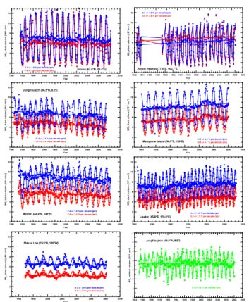
Study of the hemispheric difference in observed NO2 trends
1
0
0
Texte intégral
(2)
Figure
Documents relatifs
The left-hand side of Figure 6 depicts for three sub-cubes the faces (in dark) delimiting the feasible regions of the individual reciprocal preference relations satisfying the
We interpret this result – the lower efficiency of public investment on output when the ‘Code for Fiscal Stability’ is removed from the sample – as a first, though rough, evidence
ةياور « كوكناب ينطايش » قازرلا دبعل ةّيرهاوط ميقلاو ينماضلما في ةسارد فوّصلاوب ظيفلحا دبع ةعماج – ةليم – ...:عجرلما ... يبرعلا بدلأاو ةغّللا
Furthermore, inspired from the proof in dependent theories as well as using techniques developed for almost centralizers in this thesis, we are able to find definable envelopes up
Key in the interpretation and understanding of WISDOMs ground penetrating RADAR (GPR) measurements is the capability to correctly (and efficiently) simulate the instrument
Coupling clay swelling properties to hydro-geochemical conditions: a reactive transport modeling approach.. Christophe Tournassat, Stéphane Gaboreau,
These various instruments present different bandwidth and detector densities: AERA measures showers at frequencies between 30 MHz and 80 MHz, while CODALEMA/EXTASIS bandwidth
In the present study we observed a higher expression of NR2A mRNA in the left medial striatum and of vGluT1 mRNA in the left Cg in healthy rats.. This suggests a hemispheric
