HAL Id: hal-00299391
https://hal.archives-ouvertes.fr/hal-00299391
Submitted on 7 Dec 2006
HAL is a multi-disciplinary open access
archive for the deposit and dissemination of
sci-entific research documents, whether they are
pub-lished or not. The documents may come from
teaching and research institutions in France or
abroad, or from public or private research centers.
L’archive ouverte pluridisciplinaire HAL, est
destinée au dépôt et à la diffusion de documents
scientifiques de niveau recherche, publiés ou non,
émanant des établissements d’enseignement et de
recherche français ou étrangers, des laboratoires
publics ou privés.
New information on earthquake history of the
Aksehir-Afyon Graben System, Turkey, since the second
half of 18th century
N. Ozer
To cite this version:
N. Ozer. New information on earthquake history of the Aksehir-Afyon Graben System, Turkey, since
the second half of 18th century. Natural Hazards and Earth System Science, Copernicus Publications
on behalf of the European Geosciences Union, 2006, 6 (6), pp.1017-1023. �hal-00299391�
www.nat-hazards-earth-syst-sci.net/6/1017/2006/ © Author(s) 2006. This work is licensed
under a Creative Commons License.
and Earth
System Sciences
New information on earthquake history of the Aksehir-Afyon
Graben System, Turkey, since the second half of 18th century
N. OzerIstanbul University, Engineering Faculty, Geophysical Engineering Department, Earth Science Division, 34320, Avcilar, Istanbul, Turkey
Received: 16 October 2006 – Revised: 1 December 2006 – Accepted: 1 December 2006 – Published: 7 December 2006
Abstract. Researches aimed at enriching the number of available documentary sources on earthquakes have an im-portant role in seismology. To this end, this paper docu-ments the history of prominent earthquakes associated with the NW-SE trending Sultandag-Aksehir Fault and Aksehir-Afyon graben system in Western-Central Anatolia since the historical times through 1766. This work also combines the earthquake data for both historical and instrumental periods, previously listed in various catalogues and resources, for the studied area.
Documents from the Ottoman archives and libraries as well as the Ottoman and Turkish newspapers were scruti-nized, and eight previously unreported earthquakes in the lat-ter half of the nineteenth century and four new earthquakes in the period 1900–1931 were revealed. For the period from 1766 to 1931, the total number of known earthquakes for the area under investigation increased from eighteen to thirty thanks to the document search. Furthermore, the existing in-formation on eleven previously reported earthquakes is up-dated for the period from 1862 to 1946. Earthquakes from 1946 to 1964 are compiled from the catalogues for data com-pleteness.
1 Introduction
The Aksehir-Afyon Graben (AAG) is 4–20 km wide, 130 km long, has a NW-trending depression zone, and has been de-veloping since the Pliocene (Fig. 1). The Sultandag-Aksehir Fault (SAF) is the main border fault on the SW side of the AAG, with a dip slip rate of 0.3 mm/y (Kocyigit and Ozacar, 2003). The investigation area has encountered a series of damaging earthquakes in its history. The most recent seismic activity in the area started with the 15
De-Correspondence to: N. Ozer
(naside@istanbul.edu.tr)
cember 2000 Sultandagi-Aksehir Earthquake (Mw=6.0) and continued with the 3 February 2002 Cay-Eber Earthquake (Mw=6.5). Aftershocks on the same day (3 February 2002) included the Mw=5.8 Cobanlar earthquake, a Md=5.1 and a Md=5.0 events. While investigating the aftershock behaviour of these earthquakes (Ozer et al., 2002a, b; Ozer and Altinok, 2004), a better evaluation of the seismic activity in the past has been a requirement. This paper is the result of this re-search on the earthquake history of the region.
The information on earthquakes in the area and environs dates as far back as 94 AD, but there is a distinct dearth of data for the period between 94 and 1766 (Altinok, 2003). In order to better establish the completeness and accuracy of the historical seismic record for this area for the period from 1766 to the present, archival records including official document and newspapers from both the Ottoman and subse-quent periods, were searched, on which basis new earthquake data have been compiled. The data after 1964 is not cov-ered in this work and it can be easily obtained from the bul-letins of the related data centres. There have been fortyfive earthquakes located in the AAG between the years 1766 and 1964. These earthquakes caused damages in the localities of Afyon, Suhut, Bolvadin, Aksehir, Argithani, Ilgin and Yal-vac. The most prominent earthquakes among these were the ones that occurred in 1766, 3 November 1862, July–October 1866, 1911, 4 October 1914, 26 September 1921, 28 January 1931, 9 April 1931, and 21 February 1946. Additionally, the earthquakes of November 1862, 1911, 4 October 1914 and 28 January 1931 created surface cracks. The Heybeli Kizilk-ilise hot springs were also initiated by the 1911 earthquake.
Within this work, twelve previously unreported earth-quakes were identified, and information on eleven previously reported earthquakes was updated. The intensities for the newly revealed earthquakes are not assigned, as the obtained data is not adequate.
1018 N. Ozer: Earthquake history of the Aksehir-Afyon Graben
Fig. 1. The locations of the earthquakes that occurred in the study area from 1766 to 1964. Diamonds show the settlements. White stars
indicate the assigned epicenters by this study. The small rectangle and bold arrows in the inset map show the location of the area and the direction of plate movements, respectively. SAF; Sultandag-Aksehir Fault, NAFZ; North Anatolian Fault Zone, EAFZ; East Anatolian Fault Zone. Tectonic features in the maps are from Saroglu et al. (1987) and Barka (1992).
2 Data and information sources used in the study
Data and information about previously enrolled seismic events in the area were obtained from various catalogues and articles, including the studies of Pinar and Lahn (1952), Ocal (1968a, b), Soysal et al. (1981), Ambraseys and Finkel (1987), Ambraseys (1988), and Eyidogan et al. (1991). Var-ious archives and historical records, specifically the Ot-toman Archives and the records in Turkish Republic Prime Ministry-General Directorate of the State Archives (BOA), Istanbul Beyazit State Library, and Istanbul Ataturk Library were systematically examined. Furthermore, thirtyfive dif-ferent newspapers in Modern and Ottoman Turkish, and Eu-ropean languages were searched for reports of earthquakes in the study area.
3 Historical seismicity assessed from archival research
The data obtained from archival sources concerning the seis-micity of the area under investigation are provided below. Descriptions of earthquake effects were translated verbatim from the original sources.
Twelve previously unreported earthquakes were identified on the basis of information in records from the Ottoman archives and state libraries. These are the earthquakes of 14 November 1862, November/December 1862, 26/27 January 1866, 5 May 1866, October (?) 1867, 23 December 1877, 28 November 1885, 27 March 1891, 25 April 1900, 11 October 1901, 2 February 1915, and 29 July 1931.
New information was found concerning eleven previously reported earthquakes, which as a result are now better doc-umented. These are the 3 November 1862, July–October 1866, April 1901, 4 October 1914, 26 September 1921, 9 April 1931, 19 November 1934, 29 January 1941, 18 January 1942, 21 February 1946, and 18 March 1946 earthquakes.
The epicenters of these earthquakes are assigned accord-ing to the obtained information by the study (Fig. 1). Where the epicenter is uncertain, either the town that experienced the highest intensity, or the area where it was felt, is indi-cated. In some cases, the new data confirms the previously indicated locations. The determination or revision of earth-quake magnitude, however, is beyond the scope of this work. The earthquake information obtained within the study is grouped under two sub-topics as “newly revealed” and
“updated” below. In addition, in order to provide the com-pleteness of catalogue, the earthquakes which are mentioned in previous studies, catalogues and reports but not updated by this paper, are summarized under the topic of “previously listed earthquakes”. Consequently, a final table including all earthquakes is prepared (Table 1). The earthquakes in the same year are distinguished by the codes assigned to them as the year followed by a letter (e.g. 1862b indicates the second earthquake in 1862). I0is the maximum intensity degree at
the epicenter in Mercalli-Sieberg scale. The plus signs next to the intensities (e.g. V+) indicate slightly larger than the given values at a few locations.
3.1 Newly revealed earthquakes
14 November 1862 11:40 a.m. (local time) – Suhut
A strong earthquake occurred in Suhut, with no casualties. The walls that were damaged in the previous earthquake of 3 November 1862 were collapsed (BOA, A.MKT.MHM, 354/43).
November/December 1862 – Ilgin
Sequential earthquakes occurred in the town of Ilgin, result-ing in the damage of some houses and walls. The bridge on the Posta Street had cracks on it (BOA, A.MKT.MHM., 249/4).
26/27 January 1866 – Ilgin
From the 10th day of Ramadan onward, a series of earth-quakes occurred in Ilgin. Five earthearth-quakes occurred on 1/2 March 1866, four earthquakes during the night of 2/3 March, and ten earthquakes on 6/7 March. On the following day at 08:00 a.m. (local time) intensive shocks that resembled 5– 10 cannon blasts were felt. On 21/22 March 1866, a strong earthquake occurred at 06:00 in the morning, and damaged the gallery of the Pir Hasan mosque, resulting in an eastward inclination. Twenty houses and some walls of houses col-lapsed, but no human casualties were recorded. A nearby hot spring flowed discontinuously and the water level of local wells dropped. The bridge on the Posta Street had cracks on it (BOA, A.MKT.MHM., 354/43).
5 May 1866 Sunday 08:30 a.m. (local time) – Suhut, Agzikara
In the morning, the gallery of the minaret of the big mosque in Suhut cracked. Some old walls collapsed. In the vil-lage of Agzikara, barns collapsed and animals were killed. No human casualties were recorded (BOA, A.MKT.MHM., 358/100).
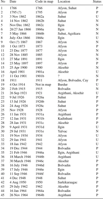
Table 1. History of the earthquakes in the studied area. N, U and P
in the “Status” column represent newly revealed, updated and pre-viously listed earthquakes, respectively.
No Date Code in map Location Status 1 1766 1766 Afyon, Suhut P 2 1795 (?) 1795 Afyon P 3 3 Nov 1862 1862a Suhut U 4 14 Nov 1862 1862b Suhut N 5 Nov/Dec 1862 1862c Ilgin N 6 26/27 Jan 1866 1866a Ilgin N 7 5 May 1866 1866b Suhut, Agzikara N 8 July–Oct 1866 1866c Ilgin U 9 Oct (?) 1867 1867 Afyon N 10 1 Oct 1873 1873 Afyon P 11 23 Dec 1877 1877 Afyon N 12 28 Nov 1885 1885 Afyon N 13 27 Mar 1891 1891 Ilgin N 14 23 May 1897 1897 Afyon P 15 25 Apr 1900 1900 Aksehir N 16 April 1901 1901a Aksehir U 17 11 Oct 1901 1901b ? N 18 1911 1911 Afyon, Bolvadin, Cay P 19 4 Oct 1914 Not in map Burdur U 20 2 Feb 1915 1915 Bolvadin N 21 26 Sep 1921 1921 Argithani, Aksehir U 22 9 Jul 1926 1926a Suhut P 23 13 Jul 1926 1926b Suhut P 24 24 Aug 1926 1926c Suhut P 25 Nov 1928 1928 Afyon P 26 11 Jan 1931 1931a Argithani P 27 12 Jan 1931 1931b Kadinhani P 28 28 Jan 1931 1931c Aksehir P 29 9 April 1931 1931d Ilgin U 30 29 Jul 1931 1931e Yalvac N 31 19 Nov 1934 1934 Afyon U 32 29 Jan 1941 1941 Afyon U 33 18 Jan 1942 1942 Afyon U 34 19 Dec 1944 1944 Bolvadin P 35 21 Feb 1946 1946a Ilgin, Argithani U 36 18 March 1946 1946b Argithani U 37 30 March 1946 1946c Aksehir P 38 16 July 1946 1946d Bolvadin P 39 17 July 1946 1946e Ilgin P 40 11 Sep 1946 1946f Bolvadin P 41 4 Dec 1948 1948 Suhut P 42 4 Aug 1950 1950 Sarkikaraagac P 43 29 July 1962 1962 Aksehir P 44 16 Jan 1964 1964a Bolvadin P 45 26 Nov 1964 1964b Argithani P
October (?) 1867 – Afyon
An earthquake occurred in Afyon (BOA, A.MKT.MHM., 391/89).
23 December 1877 – Afyon
A strong earthquake occurred in Afyon at around 11:00 a.m. (local time) on Sunday. Two walls and a meeting house col-lapsed but no human casualties were recorded (Basiret, 29 December 1877).
1020 N. Ozer: Earthquake history of the Aksehir-Afyon Graben
28 November 1885 – Afyon
Four earthquakes occurred in Afyon and two of them were rather severe. A few days later, another earthquake oc-curred and created surface ruptures in the village of Ko-pruoren (Gumus-Kutahya) (Tercuman-i Hakikat, 6/7 Decem-ber 1885).
27 March 1891 – Ilgin
A strong earthquake occurred in the town of Ilgin around 11:00 a.m. with local time on Wednesday. It lasted 2 s. No damage was recorded (Takvim-i Vekayi, 30 April 1891).
25 April 1900 – Aksehir
Two earthquakes occurred in Aksehir, one of which was rather strong (Ikdam, 28 April 1900).
11 October 1901 – ?
An earthquake was felt in Sandikli, Dinar, Suhut, Sincanli, and the surrounding villages (Sabah, 12 October 1901).
2 February 1915 – Bolvadin
An earthquake occurred in Bolvadin (BOA, DH.EUM.VRK., 14/59).
29 July 1931 – Yalvac
An earthquake that lasted 4 s occurred in Yalvac. Three houses were destroyed on Soburcayir farm (Yenigun, 10 Au-gust 1931).
3.2 Updated earthquakes
3 November 1862 – Suhut
At first, slight tremors were felt. Three days later, a strong earthquake occurred and destroyed a large part of the town of Suhut, which is situated on alluvium. There were 800 casual-ties. Water spurted out of cracks in the ground. The epicenter was on the Suhut Plain and the earthquake was strongly felt in Dinar, Afyon, and Konya (Pinar and Lahn, 1952). The date of the earthquake is given as 1863 by Pinar and Lahn (1952). Soysal et al. (1981) record the date as 16 October 1862. Nine shocks occurred from the evening to the follow-ing mornfollow-ing and activity continued for two days. Earthquake caused damage particularly in Suhut, and destroyed 15 quar-ters causing 286 casualties. A mosque in Afyon was also damaged (Tercuman-i Ahval, 11/12 November 1862; Ceride-i HavadCeride-is, 16/17 November 1862).
July–October 1866 – Ilgin
The epicenter may have been in the Ilgin region (Pinar and Lahn, 1952). A total of 34 buildings turned into
rub-ble. The bridge on the Posta Street collapsed, too (BOA, A.MKT.MHM., 365/80).
April 1901 – Aksehir
A strong earthquake occurred in Aksehir (Pinar and Lahn, 1952). Another shock occurred in Isparta and Burdur, and was felt from the south to the north, on 3 April 1901, at around 04:00 h (local time). On 4 April 1901 at 17:30, one more earthquake was felt in Isparta, from north to south (Ik-dam, 27 April 1901).
4 October 1914 – Burdur
The Great Burdur Earthquake (00:05 local time, MS=7.0; Ambraseys and Finkel, 1987). Although the epicenter of this earthquake is not in the investigation region, it is included since its effects in the study area were rather high. The earth-quake was felt with various intensities in Konya, Yenise-hir, Ilgin, AkseYenise-hir, SeydiseYenise-hir, Antalya, Denizli, Civril, Bolvadin, Alasehir, and Kutahya. There was a great number of casualties in Burdur, Isparta, Dinar, and their surround-ing villages, and extensive damage occurred. 2344 deaths were recorded and about 10 000 families rendered homeless. The large number of casualties was due to the fact that the houses were constructed with adobe and ceilings made of thick heavy mud. A 40-km-long crack, oriented SW–NE, was opened in the ground running parallel to the edge of the Burdur Lake. The epicenter was proposed to be along the crack in the Burdur Plain. The aftershocks lasted three months. In the area between Bolvadin and Cay about 100 houses were destroyed, and a new hot spring formed in the Heybeli Kizilkilise Baths (Pinar and Lahn, 1952; Cakici, 2001).
26 September 1921 – Argithani, Aksehir
The Argithani-Aksehir Earthquake (MS=5.9, 09:25:55 (UTC); Ambraseys, 1988). The earthquake occurred on the fault towards the west of the Ilgin Lake, near the Cavuscu Village, and caused significant damage to residences in the area between Argithani, Kondullu (Kundullu), and Dogan-hisar. The Cavuscu train station building was also damaged, despite its strong limestone foundation (Chaput, 1936; Pinar and Lahn, 1952). The most affected area was Sarkikaraagac, and strong shocks occurred in the direction from Doganhisar to Argithani, Dursunlu, Konari, Kundullu, Kaha, through to Turgut. The earthquake was felt slightly in Aksehir and Ilgin (Sanir, 1948).
9 April 1931 – Ilgin
The Ilgin Earthquake (M=6.1, Ocal, 1968a). The earthquake caused less damage over a smaller area as compared with the 1921 earthquake which was related to the Cavuscu fault. The Cavuscu train station building was once again damaged and
was therefore transferred to Argithani (Chaput, 1936; Pinar and Lahn, 1952; Ocal, 1968a). Significant damage occurred in Cavuscu and Argithani (Sanir, 1948).
19 November 1934 – Afyon
A local earthquake occurred in Afyon but it caused no dam-age (Pinar and Lahn, 1952). Aftershocks continued and a slight tremor was felt on 23 November at 11:30 with local time (Aksam, 26 November 1934).
29 January 1941 – Afyon
An intense earthquake occurred in Afyon but caused no dam-age (Pinar and Lahn, 1952). I0=V (Ocal, 1968a). The
earth-quake occurred at 15:50 (local time) in Afyon and did not cause any damage (Ulus, 31 January 1941).
18 January 1942 – Afyon
A low-intensity earthquake occurred in Afyon (Pinar and Lahn, 1952). A strong earthquake occurred in Afyon at 15:30 (local time) and did not cause any damage (Cumhuriyet, 19 January 1942; Ikdam, 19 January 1942).
21 February 1946 – Ilgin, Argithani
The Ilgin-Argithani Earthquake (MS=5.7, 15:43:04 (UTC); Ambraseys, 1988). The earthquake, which lasted 15 s, was felt in Ankara, Eskisehir, Kutahya, Istanbul, Bolu, Bursa, Konya, Aksehir, Sarkikaraagac, and Bolvadin. The localities most affected by the earthquake included Azari, Kaha, Dur-sunlu, Erdogdu, Melles, Apsari, and Argithani. The earth-quake consisted of two shocks separated by an interval of 12 min (Sanir, 1948). The epicenter was situated in the north of the Cavuscu Village, on the fault passing towards the west of the Ilgin Lake. Extensive damage occurred in Argithani, Cavuscu and Tursunlu, whereas light damage was sustained in Doganhisar, Urus, and Ilgin. A total of 12 people were killed and 9 were injured. In Argithani, 90 residences were demolished and 350 were rendered uninhabitable; in Ilgin 24 residences were destroyed; and in Erdogdu village 63 houses and a village mansion were destroyed (Vakit, 23 February 1946; Yeni Sabah, 23 February 1946; Pinar and Lahn, 1952; Eyidogan et al., 1991). Another earthquake that occurred between 19:50–20:00 h was felt in Ankara, Aksehir, Bursa, Bolvadin and Konya (Vakit, 23 February 1946; Son Posta, 23 February 1946; Ulus, 22 February 1946; Aksam, 23 Febru-ary 1946).
18 March 1946 – Argithani
Argithani. I0=IV–V (Ocal, 1968a). Two strong earthquakes
occurred at 14h with local time (Son Posta, 19 March 1946).
3.3 Previously listed earthquakes
1766 – Afyon, Suhut
The earthquake caused damage in Suhut. The epicenter may have been on the Suhut Plain (Pinar and Lahn, 1952).
1795 (?) – Afyon
The epicenter may be in the AAG near Afyon, but the date of the event is uncertain. An epigraph states that the Gedik Ah-met Pasa mosque (Afyon) which had been damaged a few years before 1795 was repaired in 1795 (Pinar and Lahn, 1952).
1 October 1873 – Afyon
Local earthquake in Afyon (Pinar and Lahn, 1952).
23 May 1897 – Afyon
An earthquake occurred at 02:55 (UTC), I0=IV (Ocal,
1968a).
1911 – Afyon, Bolvadin, Cay
The earthquake, which occurred in the Aksehir-Afyon Graben, caused various damage. Hot springs near the Heybeli-Kizilkilise Baths were initiated by the earthquake (Pinar and Lahn, 1952).
9 July 1926 – Suhut I0=V+ (Ocal, 1968a). 13 July 1926 – Suhut I0=V+ (Ocal, 1968a). 24 August 1926 – Suhut I0=V+ (Ocal, 1968a). November 1928 – Afyon
A high-intensity earthquake in Afyon with no damage (Pinar and Lahn, 1952).
11, 12, 28 January 1931 – Argithani, Kadinhani, Aksehir
In Argithani, 60 houses were damaged by the earthquake of 11 January (M=4.9). The second event occurred in Kadin-hani on 12 January at 15:06 local time (M=4.0). On 28 Jan-uary, an earthquake occurred in Aksehir, causing damage. In Aksehir and its villages, 154 houses and 220 barns collapsed, while in Ilgin and environs 85 houses and 4 barns were dam-aged (M=5.5). Surface ruptures appeared at Cavuskoy (Ocal, 1968a).
1022 N. Ozer: Earthquake history of the Aksehir-Afyon Graben
19 December 1944 – Bolvadin
Origin time 02:58 (UTC), I0= IV–V (Ocal, 1968a).
30 March 1946 – Aksehir
Origin time 15:10 (UTC), I0=III–IV (Ocal, 1968a).
16 July 1946 – Bolvadin
I0=IV–V (Ocal, 1968a).
17 July 1946 – Ilgin
Origin time 19:45, I0=V (Ocal, 1968a).
11 September 1946 – Bolvadin
Origin time 04:48 (UTC), I0=IV (Ocal, 1968a).
4 December 1948 – Suhut
Origin time 03:40 (UTC), I0=III–IV (Ocal, 1968a).
4 August 1950 – Sarkikaraagac
Origin time 08:40 (UTC), I0=III (Ocal, 1968a).
29 July 1962 – Aksehir
Origin time 04:30 (UTC), I0=IV (Ocal, 1968b).
16 January 1964 – Bolvadin
Origin time 15:01 (UTC), I0=III–IV (Ocal, 1968b).
26 November 1964 – Argithani
Origin time 21:00 (UTC), I0=IV (Ocal, 1968b).
4 Discussion
The results obtained from this historical record search are very encouraging. For the study area, eight new earthquakes prior to 1900 were revealed, adding to the six already re-ported in existing catalogues for the same period. Six of the new earthquakes are reported as having “caused collapse of structures and damage”, while the other two are simply re-ported as “having occurred”. For the period between 1900 and 1931, four new earthquakes were found compared to the twelve previously identified earthquakes. Reports of the earthquakes of 14 November 1862, 28 November 1885, Oc-tober (?) 1867, 27 March 1891, 25 April 1900, 11 Octo-ber 1901, 2 February 1915, and 29 July 1931 did not show any information regarding damage. Four other new earth-quakes, those of November/December 1862, 5 May 1866 and 23 December 1877 caused damage, while the earthquake of
26/27 January 1866 also created cracks in the ground and hot springs.
The most recent prominent regional event prior to 15 De-cember 2000 earthquake was the 21 February 1946 Ilgin-Argithani earthquake (MS=5.7), the epicenter of which was located at the southeastern end of the Aksehir-Afyon graben. Another earthquake occurred in 1911 near the towns of Cay and Eber (Afyon), where the 2002 macroseismic epicenter was also located. The Heybeli Kizilkilise hot spring was ini-tiated by the 1911 earthquake, and reactivated by the 1914 Great Burdur earthquake and the 2002 earthquake sequences. The new data indicate that the most affected places in the AAG are Suhut near the western end of the SAF, and Ilgin and Argithani located near its eastern end.
5 Conclusions
This study has documented previously unreported earth-quakes in the vicinity of the Sultandag-Aksehir Fault in the Aksehir-Afyon Graben, Turkey, using archival and library re-search. For the study area, eight new earthquakes prior to 1900 were identified, adding to the six already documented ones and four new earthquakes were found for the period from 1900 to 1931, adding to the twelve already known ones. The results of this study clearly demonstrate that additional archival searches could further improve the accuracy and coverage of historical seismicity for the study area as well as other areas of Turkey. Such studies should increase the knowledge of relationship between existing faults and histor-ical seismicity, and should also improve the seismic hazard assessments.
Acknowledgements. The author thanks to Y. Altinok and S. Ceylan
for their continuing support. The figures were prepared using the public domain GMT software (Wessel and Smith, 1998). The research was partly supported by the Research Fund of Istanbul University under Project No. 145/20082003.
Edited by: M. Contadakis
Reviewed by: G. Papadopoulos and I. Cecic
References
Altinok, Y.: Aksehir Depremleri, I. Aksehir Sempozyumu, 16–18 October 2003, Aksehir, Konya, 2003.
Ambraseys, N. N. and Finkel, C. F.: Seismicity of Turkey and neighbouring regions, 1899–1915, Ann. Geophys., 5B(6), 701– 726, 1987.
Ambraseys, N. N.: Engineering Seismology, J. Earth. Eng. Struct. Dyn., 17, 1–105, 1988.
Barka, A.: The North Anatolian Fault Zone, Ann. Tectonicae, Spe-cial Issue-Supplement to Volume VI, 164–195, 1992.
Chaput, E.: Voyages D’etudes Geologiques et Geomorphogeniques en Turquie, in: Memoires de L’institut Francais D’archeologie de Stamboul, edited by: De Boccard, E., Paris, 86 p, 1936.
Cakici, B.: 1914 Isparta ve Burdur Depremi, Tarih Boyunca Anadolu’da Dogal Afetler ve Deprem Semineri, 22–23 May 2000, Istanbul, 219–248, 2001.
Eyidogan, H., Guclu, U., Utku, Z., and Degirmenci, E.: Turkiye Buyuk Depremleri Makro-Sismik Rehberi (1900–1988), ITU Maden Fakultesi Jeofizik Muhendisligi Bolumu, Istanbul, 198 p, 1991.
Kocyigit, A. and Ozacar, A. A.: Extensional Neotectonic Regime through the NE Edge of the Outer Isparta Angle, SW Turkey: New Field and Seismic data, Turkish J. Earthquake Sci., 12, 67– 90, 2003.
Ocal, N.: Turkiyenin Sismisitesi ve Zelzele Cografyasi, Milli Egitim Bakanligi, Istanbul Kandilli Rasathanesi ve Sismoloji Yayinlari, 7, Istanbul, 119 p, 1968a.
Ocal, N.: Bes Yillik Turkiye Zelzeleleri Katalogu, Milli Egitim Bakanligi, Istanbul Kandilli Rasathanesi ve Sismoloji Yayinlari, 9, Istanbul, 24 p, 1968b.
Ozer, N., Altinok, Y., and Kolcak, D.: Is Afyon (Cay-Eber) quake (February 2002) Triggered by Sultandagi-Aksehir Earth-quake (December 2000), Turkey?, Abstract Book of Ninth Inter-national Symposium on Natural Hazard and Human-Made Haz-ards, 2002, Antalya, 79, 2002a.
Ozer, N., Altinok, Y., Utkucu, M., Yalcinkaya, E., Alptekin, O., Pinar, A., Kanli, A. I., and Sahin, S.: 3 Subat 2002 Afyon (Cay-Eber) Depremi Gozlem ve Degerlendirmeleri, Istanbul Univ. Muh. Fak. Yerbilimleri Dergisi, C. 15, S. 2, 11–24, 2002b. Ozer, N. and Altinok, Y.: Aftershock statistics of the 3 February
2002 Cay-Eber and Cobanlar earthquakes, International sympo-sium on Earth System Sciences, 8–10 September 2004, Istanbul, Turkey, 251–257, 2004.
Pinar, N. and Lahn, E.: Turkiye Depremleri Izahli Katalogu, Bayindirlik Bakanligi, Yapi ve Imar Isleri Reisligi, 36, 6, Ankara, 153 p, 1952.
Sanir, F.: Sultandaglari’ndan Sakarya’ya Aksehir, Esme ve Turgut Ovalariyla Yukari Sakarya’dan iki vadi boyu ve Aksehir, Ulus Basimevi, Ankara, 1948.
Soysal, H., Sipahioglu, S., Kolcak, D., and Altinok, Y.: Turkiye ve Cevresinin Tarihsel Deprem Katalogu (MO 2100–MS 1900), TUBITAK, TBAG 341, I.U.Yerbilimleri Fakultesi, Jeofizik Muhendisligi Bolumu, Istanbul, 87 p, 1981.
Saroglu, F., Boray, A., and Emre, O.: Active Faults of Turkey, Min-eral Res. Expl. Inst. Turkey, Unpubl. Report, 8643, 394 p, 1987. Wessel, P. and Smith, W. H. F.: New, improved version of Generic
Mapping Tools released, EOS, 79, 579, 1998.
Documentary sources
Turkish Republic Prime Ministry, General Directorate of the State (Ottoman) Archives: BOA, A.MKT.MHM., 249/4. BOA, A.MKT.MHM., 354/43. BOA, A.MKT.MHM., 358/100. BOA, A.MKT.MHM., 365/80. BOA, A.MKT.MHM., 391/89. BOA, DH.EUM.VRK., 14/59. Press: Aksam, 26 November 1934. Aksam, 23 February 1946. Basiret, 29 December 1877.
Ceride-i Havadis, 16/17 November 1862. Cumhuriyet, 19 January 1942.
Ikdam 28 April 1900. Ikdam 27 April 1901. Ikdam, 19 January 1942. Sabah, 12 October 1901. Son Posta, 23 February 1946. Son Posta, 19 March 1946. Takvim-i Vekayi, 30 April 1891.
Tercuman-i Ahval, 11/12 November 1862. Tercuman-i Hakikat, 6/7 December 1885. Ulus, 31 January 1941.
Ulus, 22 February 1946. Vakit, 23 February 1946. Yenigun, 10 August 1931. Yeni Sabah, 23 February 1946.