HAL Id: hal-01655055
https://hal.archives-ouvertes.fr/hal-01655055
Submitted on 4 Dec 2017
HAL is a multi-disciplinary open access
archive for the deposit and dissemination of
sci-entific research documents, whether they are
pub-lished or not. The documents may come from
teaching and research institutions in France or
abroad, or from public or private research centers.
L’archive ouverte pluridisciplinaire HAL, est
destinée au dépôt et à la diffusion de documents
scientifiques de niveau recherche, publiés ou non,
émanant des établissements d’enseignement et de
recherche français ou étrangers, des laboratoires
publics ou privés.
Study of the interannual ozone loss and the permeability
of the Antarctic polar vortex from aerosol and ozone
lidar measurements in Dumont dUrville (66.4°S 140°E)
Sophie Godin, Valérie Bergeret, Slimane Bekki, Christine David, Gérard Mégie
To cite this version:
Sophie Godin, Valérie Bergeret, Slimane Bekki, Christine David, Gérard Mégie. Study of the
interan-nual ozone loss and the permeability of the Antarctic polar vortex from aerosol and ozone lidar
mea-surements in Dumont dUrville (66.4°S 140°E). Journal of Geophysical Research: Atmospheres,
Amer-ican Geophysical Union, 2001, 106 (D10), pp.1311-1330. �10.1029/2000JD900459�. �hal-01655055�
JOURNAL OF GEOPHYSICAL RESEARCH, VOL. 106, NO. D1, PAGES 1311-1330, JANUARY 16, 2001
Study of the interannual ozone loss and
the permeability of the Antarctic polar vortex
from
aerosol
and ozone
lidar
measurements
in Dumont dUrville (66.4øS 140øE)
Sophie Godin, Valerie Bergeret, $1imane Bekki, Christine David,
and G•rard M•gie
Service d'A6ronomie du CNRS, Universit6 Pierre et Marie Curie, Paris, France
Abstract. Systematic ground-b•sed measurements of the ozone •nd •erosol
str•tospheric profile performed
in the Dumont d'Urville (66.4øS, 140øE) Antarctic
station •re used to study the •ir subsidence
in f•ll, the springtime ozone loss, •nd
the vortex confinement on •n inter•nnu•l b•sis. The d•t• obtained mostly from M•rch to October in the 1992- 1998 time period •re •n•lyzed •s • function of equivalent l•titude in order to discriminate the measurements performed inside,
•t the edge or outside the vortex. The subsidence
r•te derived from the ozone
measurements in the lower stratosphere prior to the destruction period •nd from
the volcanic •erosol measurements
in 1992 is in good •greement with the estimation
provided by r•di•tive transfer models. The •n•lysis of the ozone seasonal v•ri•tion
shows that the ozone destruction starts in the beginning of August •nd •ffects
essentially the inner vortex or inner edge regions. The destruction l•sts up to
the end of September •nd low ozone v•lues •re found up to the end of October,
confirming the isolation of the polar vortex •bove 400 K. Ozone destruction r•tes of
the order of 3%/d in the 400 - 475 K region •nd 1.5%/d •round 550 K •re derived
from the d•t• obtained inside the vortex. The ozone measurements obtained inOctober •llow to study the vortex confinement which shows the increase of the
ozone meridion•l gradient through the vortex edge from 400 to 650 K. A fine view
of the vortex edge is provided by • near d•ily series of •erosol lid•r measurements
performed in October 1992, • period when the vortex w•s deformed by planetary w•ves •nd slanted with respect to the vertical direction.
1. Introduction
Since 15 years, the Antarctic stratospheric ozone hole issue has aroused numerous investigations for the un- derstanding of the evolution of the stratosphere: the depletion of polar ozone in the winter-spring seasons is still an important scientific question for Both hemi- spheres with the annual formation of the ozone hole
over increasingly larger areas in Antarctica [Uchino et
al., 1999] and increased losses observed in the Northern
Hemisphere in the recent years, depending on the me-
teorology of the Arctic polar vortex [Rex et al., 1997;
Schultz et al., 2000]. The various campaigns performed
in Antarctica since 1987 provided a clearer understand-
ing of the ozone destruction processes occurring inside
the vortex: chemical destruction, driven by reactions
involving chlorine and bromine compounds is undoubt-
Copyright 2001 by the American Geophysical Union. Paper number 2000JD900459.
0148-0227/01/2000JD900459509.00
edly the cause. However, comparisons with theoretical
models show that model simulations tend to underesti-
mate the ozone
destruction
inside
the polar vortex
espe-
cially in the Northern Hemisphere, which was the sub-
ject of extensive
studies
in the recent
years
[Chipperfield
et al., 1996; Deniel et al., 1998]. Besides,
a quantita-
tive explanation
of the processes
causing
mid-latitude
trends is still under question:
apart from the impact
of the Antarctic
ozone
loss
on midlatitude
through
vor-
tex erosion
events
and dilution after the final break up•
the trends can be linked to heterogeneous chemical re-
actions on particulate matter such as sulfate aerosols
outside
the polar vortex as well as to changes
in the
basic stratospheric dynamics connected somehow to the
ozone destruction in the polar vortex. Furthermore, the
exchange processes between the polar and midlatitude
regions are still not fully quantified and, as stated in the
last assessment
on stratospheric
ozone
[World
Meteoro-
logical
Organization
(WMO), 1999]: "Until the trans-
port of perturbed
air in this region
is better understood,
it will be difficult to obtain a quantitative understand-
ing of midlatitude
ozone
depletion"
(see also Solomon
1312 GODIN ET AL.: STUDY OF INTERANNUAL ANTARCTIC OZONE LOSS
[1999] for a review of the stratospheric ozone depletion
issue). Thus, in order to understand the interaction
between the polar and midlatitude regions, the interest has focused recently on the area located at the boundary of the polar vortex. In the Southern Hemisphere, this area can affect the populated regions located between 50 øand 60ølatitude South owing to the increase of the size of the ozone depleted region and the movement of
the vortex linked to planetary waves.
The purpose of this article is to analyze a series of
ground-based measurements performed in the French
base of Dumont d'Urville (66.4øS, 140øE), located on the coast of the Antarctic continent. Continuous ground- based observation of the polar stratosphere is performed since 1988 in this station by the Institut Frangais de
Recherche e[ de Technologie Poloires (IFRTP), under
the scientific responsibility of the Service d'Adronomie
du CNRS (SA-CNRS). This program includes measure-
ments of the ozone and NO2 total contents by a SAOZ
(Systbme d'Analyse par Observation du Zdnith) UV-
Visible spectrometer [Pomm½r½au and Goutoil, 1988]
and of the stratospheric vertical profile of ozone and
aerosols by ozone sondes and lidar [Godin ½t al., 1994a].
The electrochemical concentration cell (ECC) ozone
soundings are performed since 1990 with an increased rate during the ozone destruction period in winter and
early spring. The lidar measurements are performed in
the frame of the Polar Ozone Lidar Experiment (POLE)
project in cooperation with the CNR-IROE of Florence
since 1989 for the aerosol and polar stratospheric clouds
and since 1991 for the ozone vertical distribution. In
parallel, radiosondes are launched daily by the French Meteorological Office for the measurement of local pres-
sure and temperature vertical profiles. These measure- ments were compared to UARS satellite measurements
in a recent study on the temporal evolution of stra[o- spheric constituents above Dumont d'Urville, from Au- gust 14 to September 20, 1992 [Ricaud ½t al., 1998].
In this work, the time evolution of the measurements
were interpreted by comparison with results from a three-dimensional chemical transport model. A gen- eral agreement was found between the measured data sets throughout the stratosphere. The agreement be-
tween the model and the measurements was better in
the middle than in the lower stratosphere. In particu-
lar, the model underestimated the ozone destruction at 46 hPa.
In winter, the dominant processes affecting the Antarc-
tic stratosphere after the formation of the polar vortex
are the air subsidence due to infrared cooling and the
formation of polar stratospheric clouds when the tem-
perature drops below a certain threshold (195 K around
18 km). In spring, the ozone seasonal variation inside
the vortex is controlled by the chemical destruction due
to the activation of chlorine and bromine compounds on particulate matter [WMO, 1999]. The climatology
of the various types of polar stratospheric clouds (PSC)
observed at Dumont d'Urville was analyzed in detail in
a previous publication [David et al., 1998], so our ob-
jective here is to use the long-term time series of ozone
and aerosol vertical distribution obtained at this station
to study the air subsidence and the ozone loss on an in-
terannual basis. The evaluation of the subsidence from
the stratospheric aerosol measurements is limited to the
period of observation of the volcanic aerosols injected in
the stratosphere by the eruption of Mount Pinatubo in
1991. Besides, the Dumont d'Urville station, located at a latitude of 66.4øS at the shore of the Antarctic conti-
nent, is particularly well suited to study polar processes
at the edge of the vortex: the measurements can sam-
ple air alternatively inside or outside the polar vortex
as the vortex moves above the continent. This partic-
ular position allows to study the permeability of the polar vortex as a function of altitude. It induces also an additional day-to-day variability which necessitates
the classification of the data with respect to the position
of the polar vortex.
This paper is organized as follows: after a descrip-
tion of the main characteristics of the aerosol and ozone
measurements, the temporal evolution of the position
of Dumont d'Urville with respect to the polar vortex is
discussed. The seasonal evolution of the ozone mixing
ratio as a function of altitude inside, at the edge and
outside the polar vortex is then analyzed. The three
following sections are devoted to (1) the evaluation of
the air subsidence in 1992 using the aerosol lidar mea-
surements obtained a year after the Pinatubo eruption in 1991 and the ozone measurements in autumn prior
to the ozone depletion period, (2) the determination of
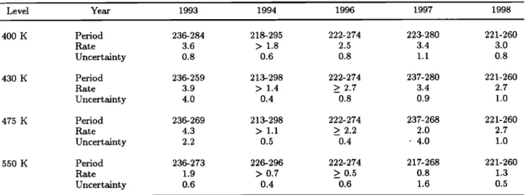
the ozone destruction rates from 1993 to 1998 at vari-
ous isentropic levels and (3) the study of the vortex edge
from 400 to 650 K using the measurements performed alternatively inside and outside the vortex in spring.
2. Description of the Measurements
The multiwavelength lidar instrument was described in detail by Stefanutti et al. [1992]. At the present
time, it is the only mixed ozone/backscatter lidar op-
erating routinely on the Antarctic continent. The lidar transmitter includes two laser sources, a XeC1 exciplex laser and a Nd:Yag laser which provide the wavelengths
necessary for both the aerosol and the ozone measure-
ments. The operation of the lidar requires nighttime
and quasi clear sky conditions so no lidar measurements
are obtained in the summertime owing to the very short
nights and year round in bad meteorological conditions.
The ozone and aerosol lidar measurement are performed each day sequentially when the experiment is possible, following a protocol based on the period of interest: an intensive aerosol period from May to July in order to study the formation of the Polar Stratospheric Clouds
(PSCs), followed by an intensive ozone period from Au-
GODIN ET AL.: STUDY OF INTERANNUAL ANTARCTIC OZONE LOSS 1313
2.1. Aerosol Measurements
The second harmonic (532 nm) of the Nd:Yag laser
is used for the particles observation [Stefanutti et al.,
1991; David et al., 1998]. The parallel and perpendic-
ular components of the 532 nm radiation are detected
simultaneously in order to retrieve the backscatter and
depolarization ratios of the aerosols or PSCs. In the
present study, we use only the volcanic aerosol measure-
ments obtained after the eruption of Mount Pinatubo in 1991. Consequently, only the backscatter ratio is
considered since the background or volcanic aerosol are
mainly liquid particles which hardly depolarize the laser
light. The backscatter ratio is defined as the ratio of
the total backscatter coefficient (the sum of the molecu-
lar and aerosol backscatter coefficient) to the molecular
backscatter coefficient.This parameter is retrieved using the Klett method, with a fix backscatter to extinction
ratio of 0.025. The molecular backscatter coefficient is
computed from the pressure and temperature (PTU)
measurements obtained daily at the station. The ac- curacy of the measurement is of the order of 5% - 8%
with a vertical resolution of 0.1 km and a temporal res-
olution of 30 min. The injection of massive amounts of sulphur following the eruption of Mount Pinatubo in 1991 provided the opportunity to study the permeabil-
ity of the polar vortex as the volcanic cloud reached the
polar regions in the spring of 1991. The cataclysmal eruption of Mount Pinatubo (15øN, 120øE), considered as one of the major eruption of the century for the cli- matic impact, took place in June 1991. High amounts of ash, dust, and sulfur dioxide were injected directly into the stratosphere, up to at least 30 km. The to-
tal mass of SO2 was estimated to 12- 15 Mt from the
spectral measurements of the Solar Backscatter Ultravi-
olet instrument (SBUV/2) [McPeters, 1993]. The sulfur
dioxide injected into the stratosphere was rapidly con-
verted photochemically to sulfuric acid vapor (H2SO4)
which formed through nucleation and condensation pro-
cesses, liquid droplets of sulfuric acid solution [Hamill
et al., 1996]. The exponential decay time of the peak
backscatter ratio was estimated to 1 4- 0.2 years (see
chapter 3 of [WMO, 1999] for a summary of the char-
acteristics of the Mount Pinatubo volcanic cloud).
As indicated by a previous publication [Godin et al.,
1996], the Pinatubo aerosols were detected unambigu-
ously from the beginning of September 1991 in Dumont d'Urville. Our measurements did not show any intru-
sion of the Pinatubo volcanic aerosol inside the vortex prior to mid-October 1991, in contrast with the small
cloud originated from the eruption of Mount Cerro Hud- son in August 1991 and located in the very low strato-
sphere around 12 km. This cloud could be detected on each measurement whatever the position of the station with respect to the vortex, while the Pinatubo cloud
located above 20 km during this period was detected
exclusively outside the vortex. From January to Novem-
ber 1992, 131 aerosol lidar measurements were obtained,
allowing
thus to study in detail the parallel
evolution
of
the volcanic cloud inside or outside the vortex. Forthe winter season of 1992, care was taken to avoid the
measurements contaminated with PSCs, according to
the method developed by David et al. [1998]. This
implies that less measurements are taken into account
especially in July and August 1992.
2.2. Ozone Measurements
The vertical distribution of ozone is measured by li-
dar in the stratosphere from 12 to 40 km, using the dif-
ferential absorption method [Godin et al., 1992]. The
absorbed wavelength (308 nm) is provided by the exci-
plex laser and the reference wavelength (355 nm) cor-
responds to the third harmonic of the Nd:Yag laser ra-
diation. The ozone number density is computed from
the difference of the slopes of the signals originated from
the Rayleigh scattering of the emitted laser beam. Since the lidar signals cover a very high dynamical range, the Rayleigh signals have to be attenuated for the measure-
ments in the low stratosphere. The final ozone measure-
ment corresponds thus to a composite profile computed
from the "high" and the "low" Rayleigh signals which
are detected simultaneously since 1996 (previously, both
measurements were obtained sequentially). A typical
experiment lasts 3 - 4 hours, leading to a horizontal spatial resolution of 100- 200 km. The vertical resolu- tion ranges from 0.5 km at 12 km to 4 km at 35 km,
with a corresponding total uncertainty varying from 3
to 15% in the same altitude range and in the absence of
PSCs. Indeed, a correct retrieval of the ozone number
density is impossible in the presence of PSCs or volcanic
aerosol at the altitude of the cloud. In this case, ozone
profiles are provided above the altitude of the cloud.
Thus the ozone lidar measurements performed in 1992 are not discussed here because of the contamination of
the data by the Mount Pinatubo volcanic aerosol in the lower stratosphere. In the beginning of 1993 and
1994, the aerosol layer was down to 16 km (420 K) and
12 km (350 K), respectively. An aerosol correction on
the ozone data was performed, using assumed values
of the aerosol angstrSm coefficients for the backscatter
and extinction terms in the ozone lidar equation [Godin
et al., 1994b]. These assumptions were derived from
the measurements of the size distribution of the Mount
Pinatubo volcanic aerosols performed by Deshler et al.
[1993]. This correction is, however, not efficient in the
case of high volcanic aerosol amounts or strong PSC events. Although the volcanic aerosol amount had de-
creased in 1993, the ozone measurements around 400 K
have thus to be considered with caution, for at least the
first 6 months. From 1996, the amount of aerosol is close to the background level in the whole stratosphere, so no aerosol correction is performed. Besides, for the whole time period considered here, the ozone measurements contaminated by the presence of PSCs are suppressed from the database. Finally, no ozone lidar measure-
1314 GODIN ET AL' STUDY OF INTERANNUAL ANTARCTIC OZONE LOSS 24 JULY 1996
:'
.. LIDAR
40 •.
ß_ ECC
ß .: ß ß . 50 o • . • 2o 5 lO o o 1 2 5 4 5 6 7 OZONE NB DENSITY (10'12 CM-5) 50 SEPTEMBER 1996 '''1'''1'''1'''1'''1'''1''''"
.. LIDAR
40 '.
ß_ ECC
:. 50• 20
lO 0 0 1 2 5 4 5 6 7 OZONE NB DENSITY (10'12 CM-5)Figure 1. Comparison of ozone profiles obtained on the same day with ECC sondes and the
ozone lidar, prior and during the ozone hole period in 1996.
ments were obtained in 1995 owing to a failure of the
exciplex laser, so this year will not be considered in this
study.
The ECC sondes provide ozone profiles from the ground to 25 km in average. They are coupled to
Va'isala sondes measuring the humidity, pressure, and
temperature. Their accuracy is of the order of 8% with
a vertical resolution of ,-• 0.2 km. A good agreement is
generally observed between the lidar and the ECC son-
des, when the measurements are performed in the same
airmass (see Figure i which shows ozone profiles ob-
tained before and during the depletion period in 1996),
so these measurements are considered to be complemen-
tary, the ECC sondes allowing to obtain ozone measure-
ments when the lidar cannot be operated (bad weather,
summer period). The improvement of the launching
procedure allowed to increase the maximum altitude
reached by the balloon especially in winter. From 20 km
in the winter of 1990, the balloons reach now routinely
an altitude of 28 km even in the lowest temperatures. The number of measurements obtained by each instru-
ment is summarized in Table 1, for the various years
considered in this study.
3. Position of Dumont d'Urville With
Respect to the Antarctic Polar Vortex
The Dumont d'Urville station is located at (66.4øS,
140
øE),on the coast of the Antarctic continent. As
mentioned previously, this position induces an addi- tional day-to-day variability from fall to spring due to the alternate sampling of the air inside or outside the
polar vortex as the vortex wobbles above the continent.
For instance, strong daily variations reaching 100 DU
in October are currently observed in the total ozone measurements, in correlation with the passage of the
vortex above the station. Similar variations are ob-
served also on the ozone lidar and sondes profiles. In
order to analyze properly the temporal evolution of the
ozone and aerosol content, the data have to be clas- sified according to the position of the station with re- spect to the polar vortex. The method employed here is the following: the equivalent latitude of the station at various potential temperature levels is determined, and the data are remapped in this potential temperature - equivalent latitude coordinate system. The equiva-
lent latitude is a modified potential vorticity (PV) vari-
able defined as the latitude enclosing the same area as the PV contour. The conservation of PV or equiva- lent latitude and potential temperature in the middle
atmosphere under adiabtic frictionless motions allows
us to use these variables as alternate coodinates [Mcin-
tyre and Palmer, 1984; Butchart and Remsberg, 1986].
The meteorological fields are obtained from the United
Kingdom Meteorological Office (UKMO) with a tem-
poral resolution of 24 hours and a spatial resolution of 2.50 in latitude and 3.750 in longitude. The vertical res- olution is close to 2.5 km in the lower stratosphere, the region of interest here. The potential temperature levels
Table 1. Number of Ozone Lidar and Sondes Measure- ments in the 1993-1998 Period
Year 1993 1994 1996 1997 1998
Lidar 30 44 68 63 35 Sondes 30 29 23 23 24
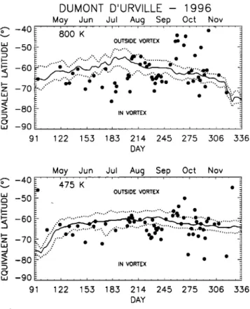
GODIN ET AL.' STUDY OF INTERANNUAL ANTARCTIC OZONE LOSS 1315 • -40 z -70 • -80 ,,, -90 9 DUMONT D'URVILLE - 1996 May Jun Jul Aug Sep Oct Nov
, , . i . . . , , , , i . , , . , , , , , . , , . , •-• ß . . _ 800 K OUTSIDE VORTEX • © © _ " '" : ' "O ß
....
. .... .
.- .
.'"
.-..,. ....
.. . IN VORTEX 122 155 185 214 245 275 506 556 DAY • -40 z -70 _>< -80 ,,, -90 9Moy Jun Jul Aug Sep Oct Nov
' ' ' I ' ' ' I ' ' ' , ' ' ' I ' ' ' I ' ' ' I ' ' ' , ' ' ' 475 K ß . OUTSIDE VORTEX
...
'"' -..J:k'".%..
....
122 155 185 214 245 275 506 556 DAYFigure 2. Evolution of the position of Dumont
d'Urville in equivalent latitude during the winter and
spring
of 1996 at 475 and 800 K (black dots). The solid
line corresponds to the limit of the vortex while the
dashed lines indicate the boundaries of the vortex edge.
used in this study range from 400 to 650 K. The method used to determine the position of the polar vortex fol-
lows the approach of Nash et al. [1996], which uses the
maximum gradient of PV as a function of equivalent
latitude: the vortex limit corresponds to the maximum
gradient of potential vorticity as a function of equiva- lent latitude constrained by the location of maximum wind jet, while the inner and outer boundaries of the vortex edge are defined from the local extrema of the second derivative of the potential vorticity. The results
of this classification are represented in Figure 2 which
shows the temporal evolution of the position of Dumont d'Urville in equivalent latitude together with the posi- tion of the vortex, from April 1 to November 30, 1996, at 475 and 800 K potential temperature levels. The
time series corresponding to the vortex limit and both
vortex borders are smoothed using a running average of
? days in order to reduce the noise inherent to the com- putation method. The dots showing the position of the station in equivalent latitude correspond to the dates of the ozone lidar and ECC measurements in 1996. Fig-
ure 2 shows that the vortex starts to form in the middle
stratosphere and propagates down to lower levels in au-
tumn, in agreement with Manney and Zureck, [1993].
In consequence, the classification method is less effi-
cient during this season, owing to the flatness of the
PV fields, especially in the lower levels. The levels lo-
cated under 400 K for instance are difficult to classify
before July. Figure 2 shows the variability of the posi- tion of Dumont d'Urville relative to the polar vortex, as a function of the isentropic level and the season' in au- tumn of 1996, the measurements are performed mostly inside and in the inner edge of the vortex at both lev- els. In winter, the vortex area is larger in the middle stratosphere than in the lower stratosphere: at 800 K the outer edge of the vortex reaches 52 o equivalent lat-
_'•L__ _1 ... _1 .,L_ •,"'"/0 ,,I ,"""/' I"L"_ T.,Z' t-I'll_
t•ucte aS comparect •o o i- at . •.ne n•easuren•ents
performed in August are more deeply inside the vortex
at 800 K than at 475 K. The decrease of the vortex
area begins earlier in the middle stratosphere than at
lower levels' at 800 K the decrease of the vortex area is
observed from the beginning of August with a marked
decrease in November. At 475 K the vortex area shows
a small decrease from September, but the vortex stays relatively stable up to the end of November. Besides,
the spring season is characterized by a higher variability
at both levels with alternate situations inside and out-
side the vortex. In the middle stratosphere the vortex is deformed by planetary waves which explains the low absolute values of the station equivalent latitude, reach- ing 450 in mid-September. The analysis of the position
of the station as a function of altitude reveals a large in-
terannual variability, as shown in Figure 3, which repre- sents the proportion of "inside," at the "edge" or "out- side" vortex situations as a function of the potential temperature and the season in 1993, 1994, and 1996.
Only these years are discussed here, since they are rep-
resentative of the interannual variability of the Dumont d'Urville equivalent latitude over the whole 1992-1998
period. In Figure 2, the percentages are relative to the
whole classification period and not to the total num- ber of observations, but the statistics of the measure- ments, which are sometimes performed every other day in winter and spring, follow these general characteris- tics. Figure 2 confirms that the equivalent latitude of Dumont d'Urville varies with altitude, which implies that care has to be taken i• the analysis of the vertical profile data. In autumn, the station is mostly located at the edge of the vortex, in the whole altitude range
in 1993. The number of "inside" situations increases with altitude while the number of "outside" situations
decreases except at the lower most levels 400 and 430 K
for which the results are more doubtful due to the less
efficiency of the classification method. This behavior is
consistent with the vortex formation in the higher levels
in autumn. In 1996, the position of Dumont d'Urville shows the same behavior except around 475 K where
more outside than inside situations are observed.
In contrast in 1994, the station is at 70% outside the vortex and never inside. In winter, when the vortex area is largest, the station is mostly inside the vortex. In 1993, the station is inside the vortex for more than 60% of the time and in the edge region for the remain-
1316 GODIN ET AL.' STUDY OF INTERANNUAL ANTARCTIC OZONE LOSS 8OO 700 600 5OO 4OO Dumont d'Urville 8OO 7OO 6OO 5OO 4OO 800 700 600
500
f
1995 autumn winter . ' , I+ edoel• t x ..'
' ;. ou( •
x
...
10 20 30 40 50 60 70 80 percentage (%) percentage (%) 1994 autumn winter '" I '\ i ß .' x 4 I I I . / , i i , i , i , i , i , i , • , i , i i , 10 20 30 40 50 60 70 80 10 20 50 40 50 60 70 80 percentage (%) outumn 10 20.50 40 50 60 70 80 percentage (%) spring \ ' , + ½ \ I: i , • , i , i , i , , , , , i , 10 20.50 40 50 60 70 80 percentage (%) spring : \ /' , \ / 10 20 30 40 50 60 70 80 10 20 50 40 50 60 70 80 percentage (%) percentage (%) 1996 winter spring.,. ....
½.
,,, ...
I \ , , \ /' , • , • , , i , • , 10 20 50 40 50 60 70 80 10 20 50 40 50 60 70 80 percentage (%) percentage (%)Figure 3. Sampling frequency of the three regions' "in," "edge," and "outside" the vortex in
1993, 1994, and 1996 as a function of the potential temperature and the season.
ing 40% especially at low altitude levels. In 1996, the
"inside" and "edge" situations are equally observed in
the lower stratosphere, while "inside" vortex situations are dominant in the middle stratosphere. The num- ber of "outside" situations is negligible. In 1994, the station is mostly in the edge of the vortex in the mid- dle stratosphere and equally inside and in the edge in the lower stratosphere. The number of "outside" situ- ations, reaching 30% at 400 K is, however, higher than in the other years at these levels. In spring, the number
of "outside" situations increases with altitude and be-
comes generally dominant above 600 K. This feature is most pronounced in 1994 and in 1996. This is consistent
with the earlier decrease of the vortex area and the less stability of the vortex due to the action of the planetary
waves at higher altitude. In the middle stratosphere, more "inside" than "edge" cases are observed in 1993, the situation being reversed in 1994 and 1996. In the lower stratosphere the "inside" and "edge" situations are equally observed in 1993, while in 1994 and 1996, the station is mostly in the vortex edge. These results prefigure already our ability to study the evolution of
the ozone or aerosol amounts in the various regions. For instance, the good sampling of the inner vortex region
in 1993 allows a better evaluation of the ozone destruc-
tion rates than in 1994, a year when Dumont d'Urville proved to be the most outside the vortex over the whole 1992-1998 period. The year 1996, as well as the other
years not discussed here, represent somewhat interme-
diate situations between these two extremes.
4. Seasonal Variation of the Ozone
Mixing Ratio as a Function of Altitude
Inside, at the Edge and Outside the
Polar Vortex
The ozone measurements in Dumont d'Urville show
that the shape of the ozone mixing ratio vertical profile
varies substantially as a function of the season and the
position of the station with respect to the polar vortex.
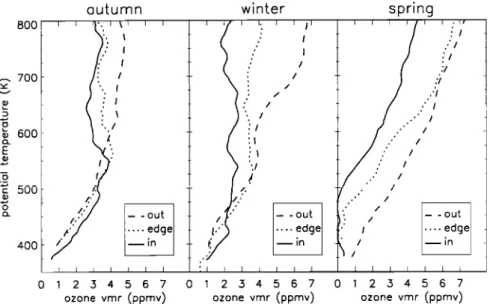
This is illustrated in Figure 4 which shows
examples
of ozone
lidar profiles
obtained
inside,
at the edge
and
outside the polar vortex in May, August, and October
GODIN ET AL.: STUDY OF INTERANNUAL ANTARCTIC OZONE LOSS 1317 8OO ,• 700 o ½• 600 E ._o r- DUU o 400 outumn / /,
'/" - -out
T
/..4 ....
edge
[•in
I I I I I I 2 5 4 5 6 7 0 ozone vmr (ppmv) w nter I, 0 2 3 4 5 6 7 ozone vmr (ppmv) spring' ' /' ! ' ' ' '/'•/'//'i
/I
'/
- -out
t:,"
// - -out
.... edge t•' I
.... .edge
-- in • //
-- •n
I I I / I I I I I I 0 • 2 3 4 5 6 7 ozone vmr (ppmv)Figure
4. Examples
of
ozone
lidar
profiles
obtained
inside,
in the
edge
region
and
outside
of
the
vortex in autumn, winter, and spring.ratio shows a positive gradient as a function of increas-
ing equivalent latitude and a strong positive gradient as
a function of increasing potential temperature. Above
this level, the situation is reverse: the vertical gradient
of ozone is weak, and the ozone mixing ratio decreases as
a function of increasing equivalent latitude. In winter, a
similar global pattern is observed with alike vertical and
horizontal gradients. The ozone profile inside the vortex
was obtained in the beginning of August, prior to the
beginning of the ozone destruction, so the ozone amount
is stil! high in the lower stratosphere. In spring, the ver-
tical gradient of ozone becomes positive both inside and
in the edge region in the middle stratosphere while the
ozone gradient as a function of increasing equivalent
Iatitude is stiI! negative. In the lower stratosphere, the
horizontal ozone gradient is now also negative due to the ozone destruction which takes place both inside the vortex and in the edge region. For the measurements performed inside the vortex, the ozone destruction is complete from 400 to 500 K.
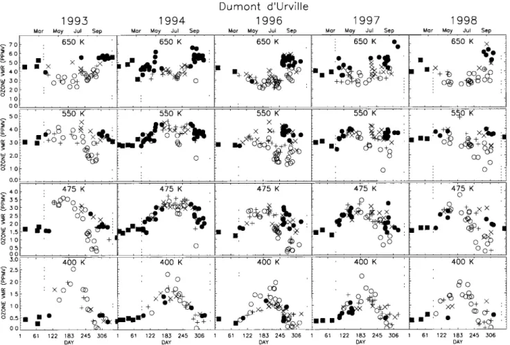
In order to give a more systematic view of the ozone
seasonal variation above Dumont d'Urville, the tempo-
ral evolution of the ozone mixing ratio retrieved from
the measurements performed in 1993, 1994, 1996, 1997,
and 1998 is represented in Figure 5 from 400 to 650 K.
The data are classified according to the position of the
polar vortex with respect to the station and no dis-
tinction is made between the ECC sondes and the li-
dar measurements, owing to the good agreement found
between both techniques when similar air is sampled.
The dashed lines mark the limit of the classification
period from April 1 to November 30. The square sym- bols represent the data obtained before and after this
period. During the classification period, measurements
performed inside and outside the vortex are represented
by open circles and filled circles, respectively. The edge
region is further divided in two regions: the inner edge
located between the inner vortex border and the vortex
limit, and the outer edge located on the opposite side of the vortex limit. The measurements performed in the
inner and the outer edges are represented by pluses and
crosses, respectively. It has to be kept in mind that the
data classification is more uncertain in April and around 400 K up to July. Furthermore, throughout the year, the classification is affected by the noise inherent to the method: despite the smoothing applied to the data, the error on the position of the inner and outer vortex bor- ders is evaluated to about 20 equivalent latitude, so data
categorized inside the vortex for instance can in reality
belong to the inner edge region. This has for effect to
blur the picture for the measurements performed when
the equivalent latitude of the station is close to one of the vortex borders. In spite of this effect, the classifi-
cation of the measurements shows the main features of
the dynamical and chemical behavior of the air masses
inside and outside the vortex. The dominant processes
affecting the ozone seasonal variation inside the vortex
in the lower stratosphere are the air subsidence due to
infrared cooling in autumn and winter and the chemical
destruction in winter and spring. In parallel, horizon-
tal mixing within the inner vortex area characterized by
rather weak PV gradients tends to flatten the ozone lat- itudinal gradients. Outside the vortex, the ozone con-
tent is controlled in winter and spring by downward and
poleward transport which brings high ozone amounts from the low-latitude regions where ozone is formed. Total ozone measurements performed in the Southern Hemisphere showed that the ozone spring maximum is most pronounced outside the vortex due to the presence of a strong polar vortex, in contrast with the Northern Hemisphere where the peak total ozone abundance is
1318 GODIN ET AL.' STUDY OF INTERANNUAL ANTARCTIC OZONE LOSS
1993 1994
Mot Moy Jul Sep Mor Moy Jul Sep
•, 7.0
650
K
650
K •
• 4.0
> •+0oO_•
, • 5.0 o•• • 2.0 ' o 1.0 0.0 Dumont d'Urville 1996 1997Mor Moy Jul Sep Mor Moy Jul Sep 650 K 650 K ß
•• • ß eel,
x X,+
:•/• ©
4.0
•)+S •
x,,•_
5.0
ß I•
• +ø ø oo x."•,,.
•.0 , o 0.0 4.0 3.5 •.o 2.5 2.0 1.5 0.5 0.0 3.0 2.5 2.0 1.5 1.0 0.5 475 Ko•
ø +
ß
475 K 475 K 400 K o xo (z) o +(•, 61 122 183 245 306 DAY 400 K o+x e¾-'•-c)
•
BBBB
©
.-+
+
61 122 183 245 306 DAY 400 K 400 K o o oo + o _•..•_ß ...
,.:, ...
61 122 185 245 506 1 61 122 185 245 ,.506 DAY DAY 1998Mar May Jul Sep
650 K x ½. , 5•0 K o o
oh+
XX
ß
''
400 K •o )e( ©+ X ß 'o ¸ Ekeß
ß
1 61 122 185 245 506 DAYFigure 5. Temporal evolution of the ozone mixing ratio sorted with respect to the position of the polar vortex in 1993, 1994, 1996 and 1998. The dash lines mark the classification period,
from April 1 to November 30. Data obtained in summer are represented by filled squares. Within
the classification period, measurements obtained inside, in the inner edge, in the outer edge, and
outside the vortex are represented Dy open circles, pluses, crosses, and filled circles respectively
The effect of the subsidence on the ozone amount
is strongest in the lower stratosphere where the ozone vertical gradient is highest. Above the ozone maximum, the vertical gradient is weak especially inside the vor-
tex, and the effect of the subsidence should be small.
The ozone increase in the lower stratosphere due to the
subsidence at one particular level stops when the ozone
maximum is reached. As seen in Figure 5, the ozone maximum is reached in August at 400 K, in June at 475 K, and in May at 550 K. The large range of ozone
values observed in the winter of 1996 at 550 K is due to
this differential effect: lower ozone amounts are already observed inside the vortex, while an ozone increase is still observed in the outer edge region.
In autumn, no clear distinction in the evolution of the ozone amount can be made between the various re-
gions, although maximum ozone values at 400 K seem
generally to be reached by measurements performed in-
side the vortex. The sampling of the ozone field by the
ground-based measurements in Dumont d'Urville does
not allow to differentiate the subsidence inside or out- side the vortex. Furthermore, additional effect linked
to horizontal mixing have to be considered here.
From August to October, two classes of data can be
distinguished according to the evolution of the mixing
ratio: inside the vortex and in the inner edge, the rapid
decrease of the ozone amounts up to 550 K is due to
the ozone destruction caused by the heterogeneous re-
actions involving active chlorine compounds. At 400 K the distinction between the various regions is weak,
and some low values are observed in measurements per-
formed outside the vortex or in the outer edge, in 1996 for instance. However, complete ozone destruction is
observed inside the vortex and in the edge region in
October. At 475 K the distinction between the ozone destruction inside the vortex and the ozone evolution
outside the vortex is clearer. Near complete ozone de- struction is generally reached at the end of September.
In 1994 measurements performed in mid-August likely
show the start of an ozone destruction, but the inner vortex region is poorly sampled afterward. No destruc-
tion rate can thus be deduced from the measurements
at this level. However, a good sampling of the outside region is achieved in 1994. This allows us to visualize the behavior of ozone in this region in autumn and win- ter up to 650 K, which is barely the case in the other
GODIN ET AL.: STUDY OF INTERANNUAL ANTARCTIC OZONE LOSS 1319
years. Besides, the rather low ozone values observed
outside the vortex in October 1997 are characterized
by an equivalent latitude of 20øS and 30øS, indicating the presence of subtropical air above the station. At
550 K an ozone decrease is observed inside the vortex
and in the inner edge in August and September, but it does not reach complete destruction as in the lower lev-
els. In October, the measurements performed inside the
vortex present a large variability, particularly in 1996 when a good sampling of the ozone field was achieved.
The analysis of the measurements as a function of the
equivalent latitude shows that the higher ozone amounts
inside the vortex correspond to measurements close to
the vortex edge (see section 7). Ozone destruction is
also observed in the inner vortex edge at this level• but
it seems smaller than the one observed inside the vor-
tex. More generally, a clear distinction can be made between the inner edge and the outer edge ozone values at 475 and 550 K, except in 1994 when the measure- ments barely sampled the ozone destruction. The inner edge ozone amounts are close to those obtained inside the vortex, while the outer edge values follow those ob-
tained outside the vortex. This illustrates the weak
mixing within the edge region.
At 650 K the temporal evolution of the ozone mix-
ing ratio is different: it shows a decrease in fall and an
increase in spring, with higher ozone amounts observed outside the vortex and in the outer edge at the latter
season than inside the vortex or in the inner edge. The
ozone decrease in fall is due to the subsidence and the
horizontal mixing consecutive to the formation of the polar vortex. In July and August the ozone mixing ra-
tio remains constant, which is consistent with the weak
vertical ozone gradient inside the vortex and the sta- bfiity of the vortex itself. No clear ozone destruction
is detected from the data in the August-September pe-
riod, but as indicated by Manney et al. [1995], the ozone destruction can be masked by dynamical pro-
cesses, mainly the diabatic descent, still occurring in
the middle stratosphere in spring.
Finally, Figure 5 shows, to some extent, the interan- nual variabi]ity of the ozone seasonal variation, despite the different sampling: the maximum ozone amounts
reached at 400 K in 1996 and 1998 are lower than
in 1993 and 1994. At 475 K, the maximum ozone in 1996 is still low as compared to the other years. Ozone
amounts inside the vortex at 550 K in winter are also
smaller in that particular year. This variability reflects the variability in the ozone transport in the Southern
Hemisphere linked to dynamical processes such as the
quasi-biennal oscillation [Butchart a•d Austin, 1996].
In sections 5 and 6 we attempt to quantify the air
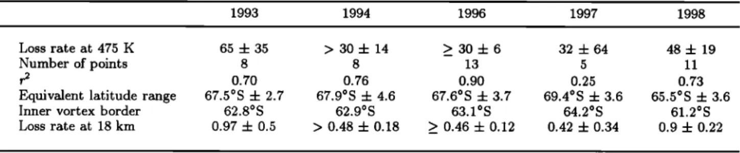
subsidence and the ozone destruction from the measure-
ments performed in Dumont d'Urville. The quantifica- tion is made only inside the vortex, since the large gra-
dients characterizing the vortex edge in both the ozone
and aerosol fields, together with the limited temporal sampling, do not allow us to obtain valid results on the
processes to be characterized. In these studies, we gen-
erally make the assumption that the Antarctic polar vortex is relatively well mixed within the area covered
by the measurements during the period under study
and that horizontal transport and mixing has a smaller
contribution to the evolution of the ozone or aerosol amount than the subsidence and the chemical destruc-
tion. Indeed, ground-based measurements provide reli-
able measurements in the lower stratosphere, but their
limited spatial coverage prevents an accurate quantifi-
cation of meridional gradients necessary to quantify the
influence of meridional advection and horizontal mix-
ing. Moreover, the measurements performed inside the vortex generally span an equivalent latitude range less than 10 ø, limiting thus the error made in neglecting the meridional gradient as a function of equivalent lati- tude. The mixing properties of the Antarctic polar vor-
tex were the object of numerous investigations which
generally show that the Antarctic inner vortex region is relatively well mixed, although less than the midlati-
tude "surf zone"' Bowman [1993] computed a diffusion
coefficient of the order of 105 m2s -• at 450 K inside
the vortex compared to 5- 10 x 105 m2s -• outside the
vortex. In a detailed study of the structure of the polar
vortex in the austral spring of 1987, $choeberl [1992]
found
values
between
104 m2s
-• in the vortex
edge
and
105 m2s
-• inside
the vortex, compared
to 5 x 10⁵ m2s
-•
outside the vortex. In a later study, the quasi-horizontal transport and mixing in the Antarctic stratosphere was
investigated with a semi-Lagrangian transport model
and a "contour advection" technique in the winter and
spring of 1992 by Chen et al., [1994]. Their results sug-
gest that passive tracers are well mixed inside the vortex
and in the midlatitude "surf zone." Calculations of the
lengthening of material contours using the contour ad-
vection technique show that in the lower stratosphere strong stirring occurs in the inner vortex.
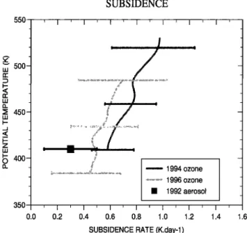
5. Evaluation of the Air Subsidence in
the Lower Stratosphere
5.1. Aerosol Measurements
In the absence of chemical processes, the air subsi-
dence around Dumont d'Urville can be evaluated from
the volcanic aerosol measurements performed in 1992
and from the ozone measurements obtained in the var- ious years during the fall season. This evaluation is
made
in the low stratosphere,
a region
where
the bulk of
the Mount Pinatubo volcanic aerosol cloud is located in1992 and where
the ozone
vertical
gradient
is most pro-
nounced. In the following studies, the subsidence rate is
defined
as the descent
rate through
the isentropes
and
corresponds to dO/dr.
In 1992 the first signature of the vortex formation on the aerosol measurements was detected on April 17, when a descent of the whole aerosol layer coincided with the appearance of a clear signal on the PV gradient
1320 GODIN ET AL.' STUDY OF INTERANNUAL ANTARCTIC OZONE LOSS
DUM¸NT D'URVILLE - AUTUMN 1992 800 ... 750 •700 n- 650 rr 600 LU 550 • 5oo i- 450 o 4O0 35O 0.5 IN EDGE OUT , ; , i 1.5 2 25 3
AEROSOL BACKSCATTER RATIO
315
8OO 750 - •700 - n,-' 650- n,-' 600- LU 550- --< 5oo- z • 450- o 4O0 - 350 -DUMONT D'URVILLE - SPRING 1992
,
z _ _ 0.5 I IN EDGE OUT i0
1.5
2
2.5
3
3•.5
4
AEROSOL BACKSCATTER RATIO
Figure 6. Average
lidar profiles
of aerosol
backscatter
ratio obtained
inside,
in the edge
region
and outside the vortex in the autumn and spring of 1992
field. The descent of the volcanic aerosol layer in 1992
is illustrated in Figure 6, which shows the seasonal av-
erage of the aerosol backscatter ratio in autumn (May-
June) and in spring (September-October) inside, in the
edge region and outside the polar vortex. The average is calculated as a function of potential temperature in
order to reduce the scatter due to adiabatic transport
processes in each region. In autumn the three regions
show similar values of the average maximum backscat- ter reaching about 3, but the altitude of the aerosol layer is the lowest inside the vortex, since the maxi- mum backscatter ratio is located slightly above 400 K, as compared to 430 K in the edge region and 450 K
outside the vortex. These results illustrate the differ-
ence in the dynamical processes around the vortex edge
region. The mean equivalent latitude of the measure-
ments averaged outside the vortex is 53•S, at -• 9 • of the
outer vortex border, compared to 70•S, at-• 8 • of the
internal vortex border for the measurements averaged
inside the vortex. In the springtime, the aerosol layer
inside the vortex has subsided down to 350 K. In the
edge region, the backscatter ratio shows a double peak,
with the lower peak located slightly above the maxi-
mum backscatter ratio inside the vortex. The double
peak structure is due to the fact that the vortex was deformed by planetary waves in October and slanted with respect to the vertical. So during this period, the
GODIN ET AL.' STUDY OF INTERANNUAL ANTARCTIC OZONE LOSS 1321 6OO 550 5OO 450 400 350 DUMONT D'URVILLE -
Feb Mor Apr Moy Jun Jul Aug Sep Oct Nov Dec
300f,,,
t,,,
•,,,
1 32 OIN + EDGE OOUT ß NO CLASS, +classification period
+ o ¸ + o 1992Jan Feb Mar
''1'''1'''1''' _ _ _ _ _ _ _ _ _ _ • - _ ß + + + o • o+
o%%O
,,,I,,,I,,,1,,,I,,,I,•,1,,,I,,,I,,,I,,,I,,,1•, 61 92 122 153 183 214 245 275 306 336 367 398 426 457 DAY from Jon 1st 1992Figure ?. Temporal evolution of the barycentric potential temperature of the volcanic aerosol
layer in Dumont d'Urville in 1992 and 1993. The data are classified according to the position of
the station with respect to the polar vortex
or the edge of the vortex in the lower stratosphere and the region located outside the vortex above. In these
measurements, the maximum backscatter ratio was lo-
cated in the lower levels, while part of the aerosol cloud
located outside the vortex was detected when the laser
beam crossed the vortex edge. All the measurements performed during this period are detailed later in the study of the vortex's permeability. Outside the vortex, the aerosol layer presents also a double peak structure but less pronounced than in the edge region. Further-
more, the value of the backscatter ratio around 350 K
is higher than in autumn. This could be explained by the higher permeability of the vortex at these low alti-
tudes allowing thus the aerosols which subsided inside
the vortex to penetrate in the outside region.
In order to evaluate the diabatic descent from the
volcanic aerosol data, we consider the temporal evo- lution of the barycentric potential temperature of the
backscatter ratio vertical distribution. The barycentric
potential
temperature
is preferred
to the altitude of the
maximum backscatter ratio in order to smooth the in-fluence of localized peaks in the aerosol cloud. It is computed as follows:
0(0)0
e•.,. feø•
R(O)
dO
(1)
where R(O) is the backscatter coefficient and 0• and 02
are the minimum and maximum potential temperature levels of the volcanic aerosol layer, respectively. The
temporal evolution of ©0,r is represented in Figure 7.
The measurements are classified according to the po-
sition of the station with respect to the polar vortex, with similar symbols as in Figure 5, except that no dis-
tinction is made between the inner and outer vortex
edge. In order to take into account the lowering of the
aerosol layer, the classification is made at the barycen-
tric potential temperature of the aerosol layer, which implies that the position of the vortex, determined ini- tially at given levels, is interpolated at ©bar for each measurement. Figure 7 shows clearly the descent of the volcanic aerosol cloud from the formation of the polar vortex in the beginning of April, with systematically lower barycentric potential temperature values for the
measurements performed inside the vortex. According
to the measurements, the subsidence around 400 K in-
side the vortex lasts up to the end of August. After this period, the aerosol layer stays roughly at the same po- tential temperature level. In the edge region, the aerosol layer is located at higher potential temperature levels,
indicating a somewhat lower subsidence. It is impossi-
ble to evaluate the rate of diabatic descent in this region
taking into account the high aerosol gradient and the inherent variability of the station's equivalent latitude through this area. Inside the vortex, the global descent of the aerosol layer is mainly due to the air diabatic
descent and to the sedimentation of the particules. The
diabatic descent rate can then be evaluated from the
temporal evolution of Oba• according to the following