HAL Id: hal-02864734
https://hal.archives-ouvertes.fr/hal-02864734
Submitted on 11 Jun 2020
HAL is a multi-disciplinary open access archive for the deposit and dissemination of sci-entific research documents, whether they are pub-lished or not. The documents may come from teaching and research institutions in France or abroad, or from public or private research centers.
L’archive ouverte pluridisciplinaire HAL, est destinée au dépôt et à la diffusion de documents scientifiques de niveau recherche, publiés ou non, émanant des établissements d’enseignement et de recherche français ou étrangers, des laboratoires publics ou privés.
Major palaeohydrographic changes in Alpine foreland
during the Pliocene-Pleistocene
Christophe Petit, Michel Campy, Jean Chaline, Jacques Bonvalot
To cite this version:
Christophe Petit, Michel Campy, Jean Chaline, Jacques Bonvalot. Major palaeohydrographic changes in Alpine foreland during the Pliocene-Pleistocene. Boreas, Wiley, 1996, 25 (131-143), �10.1111/j.1502-3885.1996.tb00841.x�. �hal-02864734�
Major palaeohydrographic changes in Alpine foreland during the
Pliocene- Pleistocene
CHRISTOPHE PETIT, MICHEL CAMPY, JEAN CHALINE AND JACQUES BONVALOT
Petit, C., Campy, M., Chaline, J. & Bonvalot, J . 1996 (June): Major palaeohydrographic changes in Alpine foreland during the Pliocene-Pleistocene. Boreas, VoI. 25, pp. 131 -143. Oslo. ISSN 0300-9483.
The changing palaeogeographical pattern of Alpine deposits across the European forelands can be traced by identifying mineral assemblages and establishing the chronology of Pliocene-Pleistocene deposits in Alpine foreland. In the late Miocene, the upper courses of the Rhine and the Aar flowed east from the Swiss molasse plain towards the Danube. In the early Pliocene (Brunssumian, 5-3.2 Ma), these same rivers headed north- wards towards the Rhine Graben of Alsace. In the early Reuverian, these streams were captured south of the Rhine Graben by the Doubs. They ceased their northward flow and headed west to feed the Bresse Graben. This phase is dated to the Lower and Middle Reuverian (3.2-2.6 Ma). From the Upper Reuverian (2.6 Ma) to the present day, the Rhine has adapted approximately its present course towards the North Sea, south to north along the Rhine Graben and across the Rhine Schist Massif to feed the Dutch Grabens. This changing pattern of capture and alteration of the hydrographic system of the upper reaches of the Rhine and the Aar can be explained by local tectonic movements.
Christophe Petit, Laborutoire de sedirnentologie et de Gkochimie du Littorul, Universite Picardie, 80039 Amiens cedex, France; Michel Campy, Jean Chaline and Jacques Bonvalot, Centre des Sciences de la Terre, URA 157 du CNRS, Universitk de Bourgogne, 21000 Dqon, France; received 2 h d March 1995, accepted 22nd March 1996.
BOREAS
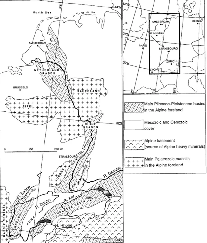
The present-day pattern of European rivers (Rhbne, Rhine, Danube) of the Alpine foreland exhibits cer- tain specific features (Fig. 1). The Danube flows east- wards along the northern boundary of the peri-Alpine molassic plain. The Rhine and its major tributary, the Aar, flow across the molassic plain, the northeast Jura and along the Rhine Graben before cutting through the ancient Eiffel Massif and on to the North Sea. The Rhone rises close to the headwaters of the Aar and the Rhine, crosses the molassic plain and the southern Juran before heading from Lyon towards the Mediter- ranean Sea. Its tributaries, the Doubs and the Sabne, rise in the Jura and the Voseges respectively and cross the Bresse basin before joining the Rhbne at Lyon.
The episodic occurrence of Alpine metamorphic of material in the Pliocene-Pleistocene deposits of the Alpine foreland basins has been used by various inves- tigators to show that this pattern has changed since late Tertiary times. Delafond & Deperet (1893) and Rollier ( 1907) reported the occurrence of Alpine cob- bles (radiolarites) and Tchimichkian et al. (1958) iden- tified Alpine heavy minerals (epidote, garnet, amphibole) in the Pliocene sediments of northern Bresse. These deposits were ascribed to the capture of
the Aar by the Doubs in the Cailloutis de Sundgau (south of the Rhine Graben) where the sand fraction exhibits the same mineralogical content (Bonvalot 1974). The advent of Alpine minerals in Bresse is correlated to the late Pliocene and early Pleistocene (Bonvalot et al. 1984). Brunnaker et al. (1977) showed that the upper course of the Rhine was aligned to- wards the Danube across the molassic plain until the early Pliocene. Geissert et al. (1976) demonstrated that Alpine sediments were laid down in the Rhine
Graben in the early Pliocene (Brunssumian) and that these deposits discontinued into the Reuverian. The first minerals from the Alps to reach The Nether- lands’ basin are dated to the end of the Reuverian (Boenigk et al. 1974; Schniitgen et al. 1975; Zagwijn 1989).
On the basis of a recent review of the infilling and dynamics of Bresse and the Alpine foreland (Petit 1993), a synthesis can now be provided of the distribu- tion of Alpine deposits in the area throughout the Pliocene-Pleistocene. To provide a uniform strati- graphical terminology, The Netherlands’ Neogene stratigraphical terminology has been adopted (Zagwijn & Dopper 1978). In this scheme, the Plio- Pleistocene boundary is placed at the base of the Praetiglian stage (2.4 Ma) and the Pliocene-Pleis- tocene Bresse infilling dealt with in this article dates back to the early Pliocene up to the early Pleistocene inclusive.
The Pliocene-Pleistocene deposits
of
Bresse
The Bresse Graben is part of the major West Eu- ropean distensive system (Bergerat 1985). It is a rift valley filled mainly with Oligocene sediments to a depth of over 1000 m (Lefavrais-Raymond 1962). The Pliocene-Pleistocene deposits form the upper part of
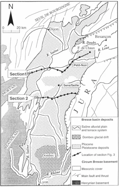
the infilling, which is irregular in thickness and seldom exceeds 100 m. Bresse is a gentle plain of some 200 m altitude, which is drained southwards by the Sabne (Fig. 2). It is bounded to the north by the plateaux of Seuil de Bourgogne and stretches southwards to the Lyon area.
132 Christophe Petit et ~ l . BOREAS 25 (1996) r /
t / i
AMSTERDAM A...
+ + + + + + +
L I L @ -A ; + + + + . :..:;:..’:.,..,. :... . .: + + ++
+ +
+ +
+ + + +
+ +
+’””
6 + +
E ’ F . E L ; - + + + / + + + + ++ +
I E R t+
+
+ + +
+
+I
Main Pliocene-Pleistocene basin:in the Alpine foreland
Mesozoic and Cenozoic cover
Alpine basement
(source of Alpine heavy minerals
Main Palaeozoic massifs in the Alpine foreland
Fig. 1. The Alpine foreland. Location of Pliocene-Pleistocene basins and current pattern of main rivers northwest of the Alps.
The geological map of Bresse and the borderlands fluvial terraces of the Sabne and its main tributaries (Fig. 2) shows the outcrop of formations. In the and in the south by the Dombes glacial region de- Bresse basin proper, the Pliocene-Early Pleistocene posited by meltwater derived from the Rhbne glacier deposits are overlain in the west by Later Pleistocene during the penultimate glaciation (Bourdier 1962;
BOREAS 25 (1996) Pliocene - Pleistocene palaeohydrographic changes, Alpine foreland 133
Fig. 2. Geological framework of the Bresse Basin and location of the sections
in Fig. 3.
Fleury & Monjuvent 1984; Campy 1992). The Bresse deposits are brought into contact with the various surrounding rock types by faulting: (1) to the north and northwest lie the limestone plateaux of the Seuil de Bourgogne which contributed few heavy minerals
con, distene, staurolite, rutile) (Duplaix et al. 1965; Bonvalot 1974) (3) to the east, the Mesozoic cover of the outer Jura is over-folded at Bresse by 5 km along
a front of more than 150
km.
Composition and geometry
to the Bresse area, in comparison to the Hercynian and AlDine deDosits: (2) to the west is the Hercvnian
basemekt (Beiujolais ‘and Morvan Hills) which pro- The Pliocene-Pleistocene Bresse infill has been vided many central upland-type heavy minerals (zir- mapped from over 500 borings drilled during the last
BOREAS 25 ( 1996) Pliocene - Pleistocene palaeohydrogruphic changes, Alpine foreland 135 Lithological units _ _ _ _ _ _ _ Sasne terrace system Sables d'Agencourt s.1 Marnes de Broin Sables de Cormoz -. ______ Marnes de Cessey Sables de Neublans Cailloutis de Desnes Marnes de Beaune
I
Molluscan chronozones BINGES INF. 3INGES SUP. \GENCOURT BROIN CORMOZ CESSEY NEUBLANS DESNES ST-SEINERodent Stratigraphical Ages chronozones , 4 i WEICHSELIAN ELSTEMAN SAALlAN M K K X U S CROMERIAN BAVELIAN M SLIYlnl MENAPIAN 2.0 Prornrmornys B R U N S S U t 4 ~ [ 4 0 -
Fig. 4. Chronology of lithological units of t h e Europeans Pliocene-
Pleistocene of Bresse.
20 years. Figure. 3 shows their composition and the geometry of deposits in two sections across the centre of the basin. Eight lithological units have been iden- tified that can be summarized in stratigraphical order as follows (Petit 1993):
Marnes de Beuune (M.Be.) are found only in the west
of Bresse and are over 100mm thick in some bore- holes. They display a lacustrine marl -limestone facies exhibiting numerous emersion levels (stromatolite crust, micro-karst, nodulization, desiccation, etc.) that are particularly marked in the upper 15 m of the unit.
Cuilloutis de Desnes (C.D.) or Cuilloutis Infkrieurs de
la Ford de Chuux is a cobble-rich formation (70%) with a clay-silt matrix (Bonvalot 1974). It varies in thickness and some boreholes have proven thicknesses of 7 0 m in the outcrop area where the Doubs stet Bresse. The upper surface dips steeply in the west.
Sables de Neubluns (S.N.) are fine to very fine, fairly
well-sorted, fluviatile sands (Bonvalot 1974; Teste 1977; Petitjean 1991; Petit 1993). They stretch from east to west and vary from 10 to 20m in thickness. They are not found on the edge of the Jura (section
B). The upper surface declines some 50 m over 50 km.
Marnes de Cessey (M.C.) are silt to sand-rich clays
which contain numerous lignite beds and in particular a continuous bed in the upper part. Faunal and floral remains in the lignites are typical of an aquatic do- main that was frequently exposed to form a swamp environment with occasional accumulations of tree trunks (Teste 1977; Puisstgur 1984). The sediments have been traced across the basin but are slightly thicker in the west (12-18 m) than the east (5-8 m). Their spiral surface falls in level irregularly towards the west.
Sables de Cormoz (S.C) are poorly sorted, fine to
medium sands with a high gravel content on the eastern margin of a fluvial environment (Bonvalot 1974; Petitjean 1991). In the cross-sections (Fig. 3 ) , they are not in contact with the Jura in eastern Bresse. They vary in thickness from 5 to 10 m. The base of the unit varies from 230 m a.s.1. in the east to 190 m a.s.1. in the west.
Murnes de Broin (M.Br) is a clay to silt formation laid
down in still water lacustrine or palustrine environ- ments (Test 1977). It is only found in the west of Bresse some 15 km from the Jura front. It ranges from less than 5 m thick east of La Seille to 20 m thick in the west. The lower surface of the unit slopes slightly from east (200 m a.s.1.) to west (190 m a.s.1.).
Sables d'Agencourt (S.A) is a sand-gravel unit that
forms the final deposit of the Bresse infill, strictly speaking. It varies from 5 to 15 m in thickness and is found only in the western half of Bresse. The base of the unit slopes slightly towards the Sabne valley depression.
The river-terruce system. Several river terraces are
superimposed on older units on the side of the Sabne valley in the west of Bresse. The geometry of the various units indicates an uprising of the oldest units (C.D., S.N., M.C. and S.C.) in eastern Bresse, while the more recent units (M.Br. and S.A.) are confined to the more western part. This arrangement indicates a westward shift of the areas of sedimentation over time and a relative uplift of the eastern border of Bresse with the Jura during the Pliocene-Pleistocene (Petit 1993).
Chronology
Studies of the palaeontological record and especially of rodent (Chaline 1984) and mollusc assemblages (Puissegur 1984) provide a time-scale for the Bresse deposits (Fig. 4). Investigation of pollen assemblages (Jan du Ch2ne 1974; Farjanel 1985; Bachiri Taoufiq 1988) allows determination of the climatic characteris- tics of each unit. Synthesis of various biological and climatic evidence allows correlation of each lithologi- cal unit with the European Pliocene- Pleistocene chronology (SUC & Zagwijn 1983; Mton et ul. 1989;
EOREAS 25 (1996)
Alps
~ -
Vosges
136 Christophe Petit et ul.
A
3 GI : Glaucophane G : Garnet A : Amphibole Ap : Apatite T : Tourmaline Mo : Monazite F1 : 34 Yo 2 1 0 -1 -2+
Mont-Dore -2 : 21 ___ S + ++
st ++
P+ +
+
*
++
++
++ , + Ma ssif Central/
I II I
VosgesJ
f Tu
-4 -3 -2 -1B
Mineral origin Minerals I 1 M Minerals 1 I i Assemblages
I
0 1 2 Hierarchical classification7 '
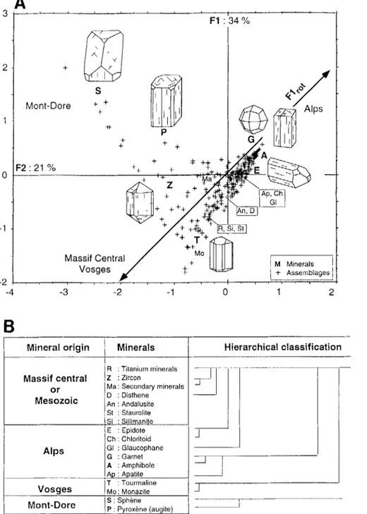
JFig. 5. Analysis of heavy mineral assemblages of the Plicoene-Pleistocene of Bresse U A. Correspondence factor analysis. 17
8.
Hierarchical1
-
cluster.-
-
-Chaline & Farjanel 1990; Rousseau et a f . 1992; Petit 1993). On this basis, the M.Be. unit is of Brunssumian age (before 3.2 Ma), the C.D. unit containing
Mi-
momys duvukosi and Mimomys occitanus is of Lower Reuverian age and the S.N. unit containing Mimomys hujnakensis is associated with a Middle Reuverian pollen assemblage. Likewise, the M.C. unit containing Mimomys polonicus and an arboreal pollen assemblage is of late Reuverian age and the S.C. containing
Mimomys polonicus and a steppe pollen assemblage is of Praetiglian age. Similarly, the M.Br. unit contain- ing Mimomys pliocaenicus is of Tiglian age, while the
S.A. unit with Mimomys ostramosensis is of Eburo- nian age. The earliest river terraces (Fv) including Mimomys savini are of Waalian to Bavelian age and the more recent accumulations (Fw, Fx and Fy) con- taining Microtus sp. are of Cromerian to Weichselian age.
BOREAS 25 (1996) Pliocene - Pleistocene palaeohydrographic changes, Alpine foreland 131
Heavy mineral assemblages
Heavy mineral assemblages
of
the Pliocene-
Pleistocene of Bresse and the chronology of
Alpine deposits
The Alpine origin of part of the Pliocene-Pleistocene deposits of Bresse has been known since Rollier
(1907) from finds of cobbles containing radiolarites that were originally known only in the Central Alps. The identification of sediment sources has been con- sidered more recently by analysing the heavy minerals of the sand facies that are abundant in Bresse. Mineral assemblages have been identified in 200 representative samples collected from the deposits as a whole (Bonvalot 1974; Teste 1977; Zanon 1978; Senac 1981). The results have been investigated using multivariate analysis (correspondence factor analysis) and hierar- chical cluster (Petit 1993) (Figs. 5A and B). Seventeen mineral types were identified and the composition of
percentage (excluding opaque minerals). The factor
Fig. 6. Mineralogical characterization of the Pliocene-Pleistocene
lithological units of Bresse by mean and standard deviation of the 200 samples has been expressed as a relative MF*2 coordinates of the correspondence factor analysis.
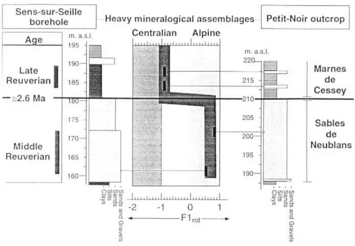
Fig. 7. Chronological position of termination of transport of heavy minerals of Alpine origin in two representative boreholes (Sens-sur- Seille and Petit-Noir).
138 C‘hristophe Petit el al. BOREAS 25 (1996)
plane Fl-F2 of the CFA analysis represents 55% of the total variability of the samples and the mineral species distributed between axis Fl (34%) and axis F2 (21%)). The values obtained are distributed along two perpendicular axes F I,,, and F2,,,,, which are diagonal compared with the FI-F2 reference lines. The FI,,,
axis reveals a slope between a group of fragile or easily weathered minerals - garnet (Gr), amphibole ( A ) epidote (E) - and a group of stable minerals -
tourmaline (T) and monazite (Mo). The F2,,, axis shows a gradient between a group of minerals from the general metamorphism of the central uplands -
sillimanite (Si), staurolite (St), disthene (D), an- dalousite (An) and zircon (Z) - and a group of
volcanic minerals - sphene (S) and pyroxene (P),
which is mainly augite.
These analyses together with the increasing rank ordering (Fig. 5B) indicate four mineral assemblages: An assemblage of Alpine origin comprising minerals from the Alpine basement - garnet (Gr), amphibole
(A) and apatite (Ap) - and from the metamorphic areas of the central Alps - garnet (Gr), glaucophane (Gl), chloritoid (Ch), epidote (E) (Tchimichkian et al. 1958; Bonvalot 1974). The occurrence of fragile min- erals (G, Ap, A) reflects rapid deposition that allows them to be conserved. The mere presence of more stable minerals (Gl, Ch, E) reflects slower deposition and perhaps some reworking. The samples character- ized by these two mineral associations are projected on the positive values of thc Fl,,, axis.
An assernhlagr of Ctwfrcil origin comprising minerals resulting from general metamorphism (D, An, St, Si) and titanium minerals - (zircon: Z) from rocks occur-
ring on the eastern edge of the Massif Central (Beau- jolais and Morvan hills’) (Duplaix et al. 1965;
Bonvalot 1974).
Aiz assemblage of Vosgian origin (tourmaline: T and
monazite: Mo) that is charactcristic of the Hercynian bascmcnt of the Vosges mountains (Tchimichkian et
cil. 1958).
An assemblage of volcanic origin (aeolian deposits) which is characterized by sphene (S) and pyroxenes ( P ) of augite type (Pastre 1987). The occurrence of volcanic minerals is ascribed to nuke ardente type eruptions (Cantagrel & Baudron 1982) and trachytic Plinian fallout (Pastre 1987) from the Mont-Dore stato-volcano in the Massif Central, 250 km southwest of Bressc (Bonvalot & Seddoh 1976; Bonvalot et al. 1984; Petit 1993). This mineral assemblage has been identified in numerous Pliocene -- Pleistocene sediments
of western Europe (Windheuser & Brunnacker 1978; Pastre 1987; Debard & Pastre 1988).
The gradient highlighted on the Fl,,, axis of Fig. 5A defines the Alpine deposits usually composed of fragile minerals as opposed to the more local deposits from the Vosges and central uplands which are made up of stable minerals. The mineral content of each
rock unit defined in Bresse can be characterized by the mean and standard variation of the co-ordinates of the Fl,,, axis for the samples analysed. It can be seen (Fig. 6) that the heavy mineral assemblages of Alpine origin are only found in the partly Reuverian age Cailloutis de Desnes and Sables de Neublans formations.
The termination of deposition of Alpine deposits in the Bresse infill is marked very precisely at the boundary between the Sables de Neublans and the Marnes de Cessey facies. The Sens-sur-Seille and Pe- tit-Noir boreholes clearly exhibit this boundary (Fig. 7). These two boreholes are some 20 km apart and show the same lithological succession. At the base, the sandy facies with Middle Reuverian palynological (Farjanel 1985) and malacological (Puissegur 1984) assemblages contain an abundant assemblage of Alpine minerals (garnet: 22%; amphibole: 29%). At the top, the marl facies with intercalated sands contain Upper Reuverian palynological and malaco- logical assemblages containing predominantly miner- als characteristic of local sediments from the Vosges (titanium minerals: 9%; zircon: 23%; tourmaline: 17%). Minerals from the Alps are highly weathered and found only in small amounts (garnet: 5.6%; am- phibole: 5.8%).
These data allow the dating of the phase of Alpine deposits in the Bresse infill. The phase begins with the accumulation of the Cailloutis de Desnes Formation and ends after deposition of the Sables de Neublans deposits. These Alpine deposits in Bresse begin at the start of the Reuverian (around 3 . 3
k
0.2 Ma) and stop before the end of the Reuverian (around 2.6Ifr
0.2 Ma). Subsequently, the northern Bresse irifill is supplied chicfly by local sediments. The occurrence of small amounts of weathered Alpine minerals in more recent sediments indicates reworking of earlier deposits.Palaeohydrographic changes in the Alpine
foreland
This issue has been covered in part by various workers in a narrower spatial framework (Bourclier 1973; Brunnacker et al. 1977) or based on morpholog- ical data (Gibbard 1988). The mineralogical and chronogical characterization of Alpine deposits in Bresse can be used as a yardstick for other basins of the Alpine foreland (Swiss molassic basin, Alsacian Graben and the German and Dutch Grabens). Five main palaeohydrographic changcs can be detected (Fig. 8).
The Rhine fAar)-Danube phase, hefore 5 Ma
Alpine deposits have been identified in the Upper Miocene formations east of the Swiss molassic plain
140 Christophe Petit et al. BOREAS 25 ( 1996)
- In the North European Grabens (sections of the
Ville area: Fortuna & Frechen) and in the Central Graben of The Netherlands where the sandy Kies- seloiilite Formation is dated to the Upper Miocene to Reuverian (Boenigk et al. 1974; Boenigk 1978, 1982; Zagwijn 1974, 1989; Zagwijn & Doppert 1978).
- In Bresse, the Marnes de Beaune of Brunssumian age are devoid of Alpine minerals.
Thus, in the Brunssumian, Alpine deposits from the RhineIAar reached the Alsacian Graben but were unknown in the Lower Rhine Grabens. The Rhine and the Aar ceased to be tributaries of the Danube in the early Pliocene and their course seems to have shifted to the northwest within the Swiss molassic plain to join the Alsacian Graben (Fig. 8B).
The RhinelAar - Douhs phase ,from 3.2 to 2.6 Ma
(Reuiwriun p .p .)
Alpine minerals have been identified in the Reuverian formations of Bresse (Cailloutis de Desnes and Sables de Neublans). In the southern part of the Rhine Graben, the lower part of the Cailloutis du Sundgau Formation contains minerals of Alpine origin (Sittler 1972). On the basis of a sedimentological study (min- eral assemblages, grain size, depth of formation, ex- tent of wcathcring), Bonvalot ( 1974) demonstrated that the Cailloutis du Sundgau formed the upstream part of the same system that deposited the Cailloutis de Desnes ( o r Cailloutis inferieurs de la ForCt de Chaux). In contrast, Reuverian age deposits in all the other basins of the Alpine foreland contain no Alpine minerals:
In the grabens of northern Europe, the overlying river-delta sand formation (the sand member of the Schinveld Gravel) and the Rcuver Clay (before the uppermost part of the Reuverian B) have assem- blages which contain no Alpine minerals (zircon, rutile and tourmaline) (Boenigk et al. 1974). The change from stable minerals to instable (molasse provenance) minerals occurs within the upper part of the Reuver Clay, or palynogically within the Reuverian B, around 2.6 Ma).
- In the Rhine Graben (Sessenheim section) where the non-decalcified sands and gravels and the indu- rated mark and clays ascribed to the Reuverian are supplied with local rivers from the Vosges (white sands with zircon and biotite) (Geissert et al. 1976). The absence of Alpine minerals in the grabens of northern Europe and Alsace, while they are present on
the north and northwest slopes of the Jura (Lower Sundgau and ForCt de Chaux), suggests that Alpine material was being transported by the Aar-Doubs. In the Reuverian (between 3.2 and 2.6 Ma), the Aar flowed out to the south of Alsace (Sundgau area) and
drained towards Bresse along the course of the present-day Doubs (Fig. 8C).
The Aar - Rhine phase from 2.6 Ma to the present
(late Reuverian to present)
Alpine mineral assemblages have been identified in post-Reuverian formations of a number of Alpine foreland basins:
- In the north of the Rhine Graben near the Ville (Koln area, Fortuna & Frechen sections), heavy minerals of Alpine assemblages appear in the Reuverian B (Figs. 8D & E ) (Boenigk et al. 1974). All the more recent deposits of the sections contain Alpine minerals (Brunnacker et al. 1977; Schniitgen
et al. 1975).
- In the Netherlands, in the Reuver Clay member, Alpine minerals are found above the peat interbed- ded between the A1 and A2 clay horizons, a change dated to the Reuvcrian B around 2.6 Ma (Zagwijn
1989).
However, in Bresse, the transport of Alpine material from the Aar-Doubs ceased in the late Reuverian (around 2.6 Ma). At this time, the Rhine captured the Aar-Doubs south of the Alsacian Graben (Sundgau area). This new palaeographic arrangement (Jura Doubs in Bresse, Aar-Rhine in the North European basins) accounts for the very different sedimentary records between the two areas from the Praetigliari to the present-day.
Praetiglian. - The cold Praetiglian stage is recorded
across the Alpine foreland by coarse detrital sedimen- tation. In northern Europe (Schotter b of the Frechen section; Boenigk et al. 1974), as the outlet of the Rh6ne in southern Bresse (Cailloutis de St Jean sur Reyssouse) (Petit 1993), this detrital pattern is appar- ent from the occurrence of coarse conglomerates. However, in northern Bresse, this pattern is shown by the deposition of sands (Sables de Cormoz). This apparently arises from the smaller catchment area of the Aar-Doubs which was confined to the Jura Doubs after the Rhine captured the Aar.
Tiglian. - Sandy material with Alpine assemblages
was transported into the Rhine Graben. They have been identified and dated at Fort-Louis, in the Hague- nau basin, north of Strasbourg (Geisser et al. 1976). In The Netherlands, the lower course of the Rhine ran south through the Central Graben during the Tiglian and later shifted slightly northeast into the Venlo Graben (Fig. 8D) (Zagwijn 1974).
Waalian. ~ In Northern Europe, the Rhine moved
westward (Fig. 8E), running beside the Rhine Schist Massif and the Sauerland northeast of Koln as it does today. From that time, the Venlo Graben was occu-
142 Christophe Petit el 01. BOREAS 25 (1996)
mainly sand and clay sedimentation developed in northern Bresse.
Conclusion
The various captures and hydrographic changes of the upper reaches of the Rhine and the Aar can only be explained by localized relative vertical movement (Fig. 9).
In the Upper Miocene, the upper courses of the Rhine and the Aar drained northeastward across the Swiss molassic plain. It seems than that this zone was still subject to subsidence at this time compared with the other areas of the Alpine foreland.
From Brunssumian times, the headwaters of the Rhine and Aar abandoned the Danube direction and were captured by streams flowing in the Rhine Graben. The graben was probably subsiding at the time, whereas the inter-river area between the upper stretches of the Danube and the Rhine was being uplifted. The most remarkable event of this palaeo- geographic evolution is the capture of the upper course of the Rhine and the Aar by the Doubs, towards Bresse, in the early Reuverian. A large allu- vial corridor developed between the south of the Rhine Graben (Sundgau area) and Bresse along the northwest margin of the Jura mountains. This stream transportcd most of the Alpine material carried by the Rhine and the Aar. This alluvial corridor ran along a syncline in front of the overlapping folds of the outer Jura during the Reuverian (Glangeaud 1949). From the end of the Reuverian, the Aar/Doubs corridor ceased to operate, as the external zone of the Jura was gradually being uplifted. This uplift brought the Alpine conglomerates to altitudes of 400 m and caused the Doubs to cut down through the Jura folds (Campy 1984). The cessation of sediment transport by Aar-Doubs to Bresse can be explained by the con- tinued tectonic thrusting during the Pliocene - Pleis- tocene. The Aar in the Sundgau area, at the foot of the Alsacian Jura, was then deflected northwards and thus flowed towards the Akacian Graben and north- ern Europe. The Rhine then permanently occupied its present valley and Alpine material was carried down to the North Sea. In the Eburonian, tectonic tilting caused the river to abandon the Dutch Central Graben for the Venlo Graben and then the Lower Rhine Embayment.
References
Bachiri Taoufiq, N. 1988: Etude palynologique dans le Neogkne et le Pleistocene inferieur de Bresse, France (sondage P et C de Reaune, C6te d’Or). These Universiti: de Lyon 1, 120 pp. Bergerat, F. 1985: Deformations cassantes et champs de contrainte
tertiaires dans la plate-forme europkenne. Thtse Universite P. et
M Curie, Paris, 347 pp.
Boenigk, W. 1978: Schwermineralassoziationen im Grenzbereich TertiarlQuartar der Erft-Scholle (Niederrheinische Buchrt).
Fortschritie in der Geologie Rheinllund und Westphulen 28, I23 -
133.
Boenigk, W. 1982: Der Einfluss des Rheingraben-systems auf die Flussgeschichte des Rheins. Zeitschrift ,fur Geomorpholgie N.F.
42, 167-175.
Boenigk, W. 1987: Petrographische Untersuchungen jungtertiarer und quartarer Sedimente am linken Oberrhein. Jber Mitt. Luber-
rhein. geoi. Ver. N.F., Stuttgart 69, 357 394.
Boenigk, W., Brelie von der, G., Brunnacker, K., Koci, A,, Schlickum, W. R. & Strauch, F. 1974: Zur Plioziin-Pleistozin- Grenze im Bereich der Ville (Niederrheinische Bucht). Newsletter
Stratigruphy, Leiden 3- 4, 219-241.
Bonvalot, J. 1974: Les Cailloutis de la Forst de Chaux (Jura); leurs rapports avec les matkriaux dttritques de Sundgdu el du Nord de la Bresse. These Universite Dijon, 89 pp.
Bonvalot, J., Courel, L. & Senac, P., 1984: Etude stdimentologique du remplissage plio-pltistockne de la Bresse. Gtologie de la France Bonvalot, J. & Seddoh, K. F. 1976: Ntogenese de sphkne dans les marnes villafranchiennes de la Bresse septentrionale. Comptes
Rendus de la Sociiti Giologique de France, Paris 5, 223-225.
Bourdier, F. 1962: Le Bassin du Rh6ne au Quaternaire. Edition de Centre National de la Recherche Scientifique, Paris, 364 pp. Bourdier, F. (Coordinateur) 1973: Les problemes de la limite Plio-
quaternaire dans le bassin du Rh6ne. In L e Quuternaire: gkody-
namique, stratigraphie et environnement. IXeme Congres de
I’I.N.Q.U.A., Christchurch, 9- 15.
Brunnacker, K., Tobien, H., Brelie von der, G. 1977: Pliozan in der Bundesrepublik Deutschland. Ein Beitrag zur NeogenlQuatar- Grenze. Giornulr di Geologica, Bologna, (2). t. 41, fasc. 1-2,
131 163.
Campy, M . 1984: Signification dynamique et clirnatique des forrna- tions et terrasses fluviatiles dans un environnement de moyenne montagne, Bulletin de I’Association Franpise d’Etude du Quatw-
nuire 113, 87-92.
Campy, M., 1992: Palaeogeographical relationships between Alpine and Jura glaciers during the two last Pleistocene glaciations.
Palueageography, Palaeaclimarology, Palueoecology Y3, 1 - 12.
Cantagrel, J. M. & Baubron, J. C. 1982: Chronologie K-Ar des Cruptions dans le massif volcanique du Mont-dore: implications volcanologiques. Gkologie de la France 2 (1-2), 123 142. Chaline, J. 1984: La sequence des Rongeurs de Bresse en tant que
reference biostrdgrdphique et pa1i:ochmatique. Gkologie de 11
France 3, 251-258.
Chaline, J. & Farjanel, G. 1990: Plio-pleistocene rodent biostragra- phy and palynology of the Bresse basin, France and correlations within western Europe. Boreus 19, 69-80.
Debard, E. & Pastre, J. F. 1988: Um maryuer chrono- stratigraphique du Pleistocene moyen i la periplierie du Massif Central: la retombee A clinopyroxene vert du Sancy dans le site dc Orgnac 111 (Bas-Vivarais, SE France). Comptes Rendus de I ’ A - cudtmie des Sciences, Paris. t. 306, Serie 11, I5 15- 1520. Delafond, F. & Deperet, C. 1893: Les terrains tertiaires de la Bresse
et lcurs gites de lignites et de minerais de fer. Etude des gites mineraux de la France, Paris, Imprimerie nationale, 332 pp. Duplaix, S., Guillaume, S. & Lefavrais-Raymond, A. 1965: Le
Tertiaire de la Bresse, stratigraphie et minkalogie. Comparison avec les rCgions avec les regions voisines. Revue de Gtogrclphze
Physique ei de Geologie Dynumique, Paris, (2). 7, fasc. 2, 135-
148.
Farjanel, G. 1985: La flore et le climat du Neoghe et due Pleistodne de Bresse (France) d’aprts I’analyse pollinique. Implications chronostratigraphiques. Dacunienfs B.R.G.M. 97, Fleury, R. & Monjuvent, G. 1984: Le glacier alpin et ses implica-
tions en Bresse. Giologie de Iun France 3, 231 240.
Geissert, F., Menillet, F. & Farjanel, G. 1976: Les alluvions rhenanes plioquaternaires dans le dtpartment du Bas-Rhin. Sci-
ences Giologies Bulletin, Strasbourg 29(2), 121 - 170. 3, 197-220.
BOREAS 25 (1996) Pliocene -Pleistocene palaeohydrographic changes, Alpine foreland 143
Gibbard, P. L. 1988: The history of the great northwest European rivers during the past three million years. Philosophical Transac-
tions OJ the Royal Society of London, 8318, 559--602.
Gleneaud, L. 1949: Evolution morphotectonique du Jura septentri- onal pendant le Miodne superieur et le Pliocene. Comptes Rendus
de I’dcadimie des Sciences, Paris 229, 720-722.
Jan du Chine, R. 1974: Etude palynologique du NCogene et du Pltistoctne inferieur de Bresse (France). These Universite de Geneve, 240 pp.
Lefavrais-Raymond, A. 1962: Contribution a I’ttude geologique de la Bresse d’apres les sondages profonds. Memoire du B.R.G.M.
16, 170 pp.
Meon, H., Bachiri, N. & Puissegur, J. J. 1989: Analyses sporo- polliniques du sondage de Beaune (NW de la Bresse, France). Stratigraphie et restitution climatique. Revue de Micropaliontolo-
gie 324) 277-292.
Pastre, J. F. 1987: Les formations plio-quaternaires du Bassin de I’Allier et le volcanisme regional (Massif Central, France). These Universite Paris 6, 733 pp.
Petit. Ch. 1993: Un bassin d’avant-pays de type pelliculaire: la Bresse au Plio-pleistockne. Thise Universite de Dijon, 335 pp. Petitjean. E. 1991: Contribution a I’etude geologique du faisceau
ledonien et des formations plio-pltistocknes de la Bresse jurassi- enne. These Universite de Franche-Comtt, 281 pp.
Puissegur, J. J. 1984: Les faunes malacologiques de la Bresse. Significations ecologique, climatique et chronologique. GCologie
de la France 3, 28 I - 302.
Rollier, L. 1907: Sur la provenance des galets et des sables de la Forit de Chaux (Jura). Bulletin de la Societi d’dgriculture de
Haute-Sacine 18, 209-232.
Rousseau, D. D., Petit, C., Taoufiq, N. B., Farjanel, G., Meon, H.
& Puissegur J. J. 1992: Continental late Pliocene paleoclimatic history recorded in the Bresse basin. Palaeogeography, Palaeocli-
matology, Palaeoecology 95, 253-261.
Schniitgen, A.,.Boenigk, W., Brunnacker, K., Koci, A & Brunn, K. 1975: Der obergang von der Hauptterassenfolge zur Mitelter- rassenfolge am Niederrhein. Dechaniana, Bonn 128, 67 -86. Senac, P. 1981: Le remplissage detritique plio-pleistodne de la Bress
du Nord. Ses rapports avec la Bresse du Sud. These Universite de Dijon, 235 pp.
Sittler, C. 1972: Le Sundgau, aspect geologique et structural. Sci-
ences Giologiques Bulletin, Strasbourg 25 (2-3), 93-1 18. SUC, J. P. & Zagwijn, W. H. 1983: Plio-Pleistocene correlations
between the northwestern Mediterranean region and northwest- ern Europe according to recent biostratigraphic and paleoclimatic data. Boreas 12, 153-166.
Tchimichkian, G., Reulet J. & Vatan, A. 1958: Etude pit- rographique des mattriaux molassiques de quelques sondages profonds de la Bresse. Eclogue geologicae Helveticae 51(3), 1093- 11 14.
Teste, J. 1977: Etude sedimentologique des formations plio-quater- naires de la Bresse du Nord. Feuilles a I/50000 de Chagny, Pierre et Poligny. These Universite de Dijon, 96 pp.
Windheuser, H. & Brunnacker, K. 1978: Zeitstellung und Tephro- stratigraphie des quartaren Osteifel-Vulkanismus. Geologisches
Jahrbuch Hessen, Wiesbaden 106, 261 -271.
Zagwijn, W. H. 1974: The paleogeographic evolution of The Netherlands during the Quaternary. Geologie en Mijnbouw 53, Zagwijn, W. H. 1989: The Netherlands during the Tertiary and the Quaternary: a case history of Coastal Lowland evolution. Geolo-
gie en Mijnbouw 68, 107-120.
Zagwijn, W. & Doppert, J. W. 1978: Upper Cenzoic of the southern North Sea basin: Palaeoclimatic and Plaeogeographic Evolution.
Geologie en Mijnbouw 57, 577-588.
Zanon, F. 1978: Leve cartographique de la feuille de Louhans a 1/50000. Etude sedimentologique de la Bresse louhannaise. These Universitt de Dijon, 64 pp.