HAL Id: hal-02343029
https://hal.archives-ouvertes.fr/hal-02343029
Submitted on 1 Nov 2019
HAL is a multi-disciplinary open access
archive for the deposit and dissemination of sci-entific research documents, whether they are pub-lished or not. The documents may come from teaching and research institutions in France or abroad, or from public or private research centers.
L’archive ouverte pluridisciplinaire HAL, est destinée au dépôt et à la diffusion de documents scientifiques de niveau recherche, publiés ou non, émanant des établissements d’enseignement et de recherche français ou étrangers, des laboratoires publics ou privés.
Charith Perera, Omer Rana, Benoît Goossens, Pablo Orozco-ter Wengel
To cite this version:
Charith Perera, Omer Rana, Benoît Goossens, Pablo Orozco-ter Wengel. Internet of Things for Efficient Wildlife Conservation: Challenges and Opportunities. [Research Report] Cardiff University. 2019. �hal-02343029�
V1.0 (Last Update 2019-10-31) JAN-JULY 2019 COMSC and BIOSI with DGFC
Charith Perera (PI), Omer Rana, Benoît Goossens, Pablo Orozco-ter Wengel
Internet of Things for Efficient Wildlife
Conservation: Challenges and Opportunities
Page | 1
Internet of Things for Efficient Wildlife Conservation:
Challenges and Opportunities
Charith Perera (PI), Omer Rana, Benoît Goossens, Pablo Orozco Ter Wengel
Danau Girang Field Centre (DGFC) is located in Sabah Malaysia (marked in Figure 1). The only access to the field centre is through the river. Similarly, all the research activities are conducted by going through the river. It is worth noting that Sabah Malaysia is a high humidity region where electronic components could get damaged quite quickly due to environmental factors such as moisture. Further, in jungle terrains, insects could also get attracted to copper within electronic components. We need to keep in mind this context when we are addressing the challenges. We conducted a two full-day workshop to explore and identify research challenges that could potentially be addressed using the Internet of Things (IoT) technologies. During this workshop, we identified two major areas to focus on:
(1) Sensing Infrastructure, and (2) Data Science.Additionally, we also discussed citizen engagement research, where we could work with local schools and universities to share our technical expertise with the local community. In the long term, such activities will help local communities to develop technologies to solve their own problems.
Figure 1: A map the region of the Kinabatangan Wildlife Sanctuary Sensing Intrastructure
•Trap Activation Detection •Poacher Tracking
•Poacher Detection
•Data Communication in Jungle Terrains •Remote Camera Trap Battery Monitoring
Data Science
•Automated Camera Trap Image Annotation •Semantic Data Integration for Wildlife.DATA
Page | 2
1. Sensing Infrastructure
Challenge 1: Trap Activation Detection
Catching animals and tagging them is a common task in wildlife conservation activities and bioscience research. Let examine the process of catching and tagging animals. First researchers need to develop different types of traps, as shown in Figure 2. Each trap is typically custom-designed to target a specific type of animal-based on their characteristics. The next step is to deploy these traps in areas where the targeted animal wander around. Typically, there is a significant distance between the deployment location and the field centre. Furthermore, at a given time, there could be more than 20 traps deployed within the sanctuary. Typically, the research area could be 20 miles from each side of the field centre. Therefore, at least two staff members of the DGFC need to travel in boats and visit each of these traps across the 40-mile strip. Such visitations take a significant amount of time and effort. Further, these visitations need to be done daily, because if an animal has been trapped, either they need to be tagged or released.
These traps are not perfect and mostly have weight-based or bait base activation triggers. Therefore random animals could also get trapped in these traps (due to similar weight or attracted to similar baits). If this is the case, staff members only need to open the trap door and let the animal go otherwise; it would die within the trap. However, if the animal is the interested targeted animal, then the DGFC staff needs to send a message to the Sabah wildlife department, and the relevant officials need to be present in order to conduct the tagging. Due to this uncertainty, DGFC staff member needs to visit each trap every day to check them manually.
We believe that technology can be developed to monitor these traps remotely and inform the field centre staff to take the necessary actions without physically visiting the trap all the time. Such remote monitoring will reduce the workload of field centre staff and enhance their capabilities. There are two levels of technology that we can develop. First, if we can identify whether a particular trap door has been activated (i.e., closed), it will help the field centre staff only to visit the trap once activated. However in an advanced approach, if we can identify the animal remotely without visiting the trap, it would help the field centre staff to send the message to the Sabah wildlife department and ask them to come to the trap so they can perform the tagging straightaway. Such approach will save DGFC staff time as they do not need to wait near the trap until the wildlife of officials arrives due to pre-coordination ability (i.e., remote monitoring helps to coordinate the trap visitation efficiently). We believe that trap door activation can be detected by a few different ways. For example, trap door activation could be detected by using different types of sensors such as vibration, noise, light, motion, and camera and so on. Further, there are two different technologies that can be used to do the communication between the traps and the field centre. For example, we could use SMS or 3G technologies. It is important to note that 3G technology only works in very few limited spots within the sanctuary due to lack of signal penetration.
Furthermore, we could use low-cost edge computing technologies to detect and identify the animal trapped within a given trap. State of the art deep learning is sophisticated enough today to be able to use in such identification. However, it is difficult to predict how these models would behave in unconstrained environments such as Sabah, where many environmental factors could affect the ability of the model to predict accurately. The lighting conditions, raining, dust, insects and many other factors could affect the camera. Therefore, deep learning models which are trained to predict within specific environmental conditions may not be able to perform as expected.
Page | 3
Challenge 2: Poacher Tracking
Poaching is a significant challenge in Sabah Malaysia. Anti-poaching efforts can be divided into many different areas. Two of those areas are poacher tracking and poacher detection. The objective of poacher tracking is not necessarily to stop or catch the poachers. The objective is to track how poachers behaviour and try to understand the pouching ecosystem holistically. Most of the poachers do ordinary jobs during the daytime. At night they become poachers. Poachers not only catch or kill animals, but they also sell meat to local restaurants. Then these local restaurants sometimes offer meat to unsuspecting tourists. Poachers may also sell skin and other body parts of the animals to different buyers.
The only way to stop poaching is to understand the entire ecosystem and the stakeholders and take necessary measures to discourage them all from engaging in poaching and related activities. Therefore, we need to develop technologies to track poachers’ movements. Some crucial questions that need to be answered are, what are the shops poachers visit the most, on what days what time
they visit these places, do the poachers meet each other, and so on. Catching one or two pouches here
and there will not change the situation. One arrested poacher may be replaced by new pouches as long as the demand and the infrastructure for poaching activities present in Sabah. It is going to be difficult to stop poaching without targeting the entire stakeholders.
Sun Bear Trap (Both side open barrel)
Civets
(Single door entry box trap)
Leopard Cats
(Square bigger both side open)
Clouded Leopards (Double door box trap)
Page | 4 It is challenging to track humans in areas like Sabah, where CCTV like technology is not well
deployed. Therefore the better way to track poachers is through tracking their vehicles. We believe one way to achieve this is to deploy small tracking nodes (i.e., small electronic devices) that can communicate location information to the officials. Such tracking nodes can be deployed in poachers’ vehicles using informants. The major characteristics of such tracking nodes are: (i) be able to collect and store data while offline, (ii) long-lasting battery life, and (iii) smaller in size.
Network communication in Sabah is a challenge, especially in jungle terrain where urban technologies such as 3G and LoRaWAN, are challenging to employ. Therefore, we believe primitive technologies such as SMS are the best way to go forward. However, we also believe that a combination of different communication technologies could be more effective. Tracking nodes that can adapt based on the context and use the most efficient communication technology are the most ideal. The challenge is that the more sophisticated the tracker node becomes, the larger it will become. Larger size tracker nodes are challenging to be deployed in poacher vehicles through informants without getting noticed. Another challenge is that in certain jungle areas, long-range communication technologies do not work at all. In such situations, short-range communication technologies such as Bluetooth Low Energy (BLE) could be used. However, technology such as Bluetooth could be affected by environmental factors as well as humidity. Further, BLE may also require static infrastructure. Therefore, BLE will require many numbers of nodes to be deployed in many different strategic locations to track poacher vehicles.
Challenge 3: Poacher Detection
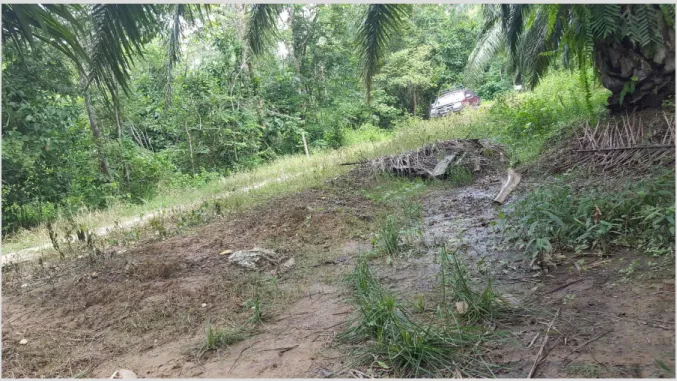
The objective of detecting poachers is to catch/arrest them. However, sometimes, poacher detection technology can also be used to track poacher the moment in a limited way. In Malaysia Sabah, poachers use two primary modes of transportation for poaching activities: four-wheel drives and boats. Most of the time, poacher may combine the two transportation mechanisms and work as teams. The following Figure 3 shows the borderline between Palm oil plantation and the sanctuary.
Page | 5 Usually, poachers would come by a four-wheel drive and stop the vehicle within the buffer between the oil plantation and the sanctuary. Then they cross the electric fence (deployed to discourage elephants, typically switched off until elephant warning triggers) and go into the sanctuary. Then they kill or capture the animals and then get into the boats and get out through the river. Sometimes group members may come back and pick up the vehicle during the night or the next day. Typically, plantation workers or any other officials in plantations are not interested in stopping poaching neither they have any authority to do so. As plantations are very large, it is unlikely that any workers would see pouches at all. To detect poachers, we need to develop two types of technologies targeting the two types of transportations modes (i.e., vehicles and boats). Another important aspect to keep in mind is that poaching happens at night, so whatever the technology we develop should be able to work with limited lighting conditions.
Vehicles Detection: There are two levels of detection that can be done in relation to the poacher
vehicles. First, it is important to detect whether there is a vehicle or not. In the sanctuary, it is prohibited for vehicles to enter (or stay) after evening (7 pm). Therefore, if there a vehicle is detected within Sanctuary during after-hours, it is fair to assume that it is a poaching vehicle. Therefore necessary actions could be taken to inform the law enforcement and wildlife officers. Further, if it is possible to detect and read the license plate pf the vehicle, it could give more evidence. A license plate number helps to decide whether a given vehicle is a poaching vehicle or authorised vehicle. For example, we can have white-listed license plate used by authorised personal. So if such an authorised license plate is detected within sanctuary during after-hours, we can ignore them. There could be many different ways to detect vehicles. For example, we could use sensors such as cameras, noise, vibration, infrared to detect vehicles. The challenge is to find out what technique works best within this area of Sabah.
Figure 4: (A demonstration only) Poacher vehicle drives along the electric fence in the buffer area
Boat Detection: As we discussed earlier, another major transportation mode used by poachers are
boats. Boats come through river and park on river banks. Then the poacher would go into the jungle terrain and capture or kill the animal and come back with the animal. The difficulty of detecting poacher boats is that the fishermen also use boats to travel for fishing during the evening and night hours. Therefore, just because we detect a boat in the River, even within us afterwards, it is challenging to conclude that the boat is a poaching boat. It is also difficult to use sound sensors because most of the poaching boats, as well as fishing boats, use similar engines. Therefore, it would
Page | 6 be challenging to detect poacher boats by only observing movements in the river. However, fishing boats have certain behaviours when they move through the river. Poachers are likely to get down from the boat on river banks.
Another approach could be to combine the data we gather from vehicle detection sensors and combine that knowledge with boat tracking data. For example, if see a pattern of both boat and vehicle moving towards a similar direction, then we could imagine based on past data that group of poachers may be working together to catch or kill animals.
Figure 5: River where poachers use to get away after catching or killing animals
Challenge 4: Data Communication with Jungle Terrains
As we discussed earlier, most of the long-range communication technologies we use in urban areas are not working within jungle terrain, because of the obstacles such as the thick canopy and high humidity. Lack of network connectivity is one of the major issues that directly impact all other challenges. For example, we discussed trap door activation before. Even we detect trap door activation, without network communication, it is not possible to send the message to the official's on-time. Therefore, most of the time, we have to rely on technologies such as SMS, 3G or satellite communication.
Satellite communication is costly. On the other hand, 3G communication only available in certain spots within the sanctuary. Therefore, the most practical solution seems to be SMS. However, we believe that technologies such as Lora and Xbee can be utilised to develop a cheaper network. Due to obstacles such as high humidity, both Lora and Xbee technologies do not provide the performance as they would in urban cities. Therefore, we expect that the coverage these technologies provide to be much less in jungle terrains that their official specifications.
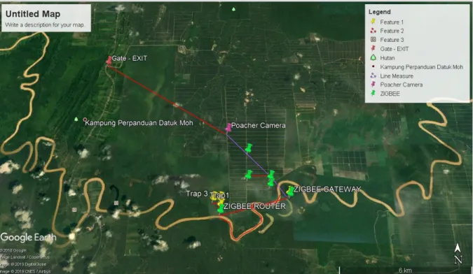
Page | 7 We believe that it is useful to combine these two technologies (i.e., Lora and Xbee) to develop an efficient and effective network. Lora is designed for long-range communicate (10+ Km). However, the packet size that it can transfer is quite small (few KB). Such small packets are good enough to send a message from a trap door to the field centre. However, it would be difficult to send an image over a Lora network. It is ideal to have Xbee as the backbone of the network. For example, we could deploy a series of Xbee gateway node along the river bank where data would be hope from one to another. Then, the communication between the river bank and the jungle terrain can be done using Lora as depicted in Figure 6. In doing so, we could utilise best of both worlds of Lora and Xbee. Such infrastructure will help researchers to monitor different aspects of the sanctuary and animals in a much more efficient and effective manner.
Figure 6: Potential Pilot IoT Network
Challenge 5: Remote Camera Trap Battery Monitoring
Camera traps are widely used in wildlife research to monitor behaviours of animals. They are typically deployed remotely and expected to be triggered by animal movements. Cameras are configured to take photographs or video. Usually, researchers are not visiting these camera traps every day. Ideally, cameras will be deployed for 1-3 weeks, and the researchers will collect them. However, it is difficult to predict when the battery would die. Most of the camera traps use rechargeable batteries. Even though some batteries get fully recharged once deployed, they tend to dry out very quickly. Sometimes, for example, a researcher may deploy a camera trap, and within one day, the battery gets dried out. However, the researcher may not know that the battery has died. Once return in a week or two, they will get disappointed to know that none of the footage has been recorded. To avoid address this issue, we need to develop technology that can at least detect and notify the researchers when the batteries are dead, because predicting battery life ahead of time is extremely difficult due to harsh environmental condition (rain, humidity). We can develop technology (contact or non-contact) to measure the voltage of the batteries and notify researchers once the voltage drops below a certain amount.
Page | 8
2. Data Science
Challenge 1: Automated Camera Trap Image Annotation
As mentioned earlier, camera traps are one of the most common ways that wildlife researchers collected data about animals and their behaviours. First, researchers may deploy cameras in the wild. Then they bring the camera back to the centre and move the photos or videos from the memory chip to a computer. Then, they need to review each photo and annotate them manually with various parameters such as whether there is animal or not in the photo, what type of animal and so on. Such a review process is a challenging task, and it also takes a significant amount of time to review thousands of images.
Artificial Intelligence (AI) technologies can automatically detect animals in a given photo. Further, some AI models can recognise animal types and their behaviours as well. There are many different deep learning classifiers developed and trained by many different institutions and researchers. However, none of those classifiers is perfect. Accuracy also depends on environmental parameters as well, which affected by the image quality. We believe that the best way to go forward is to develop a method to combine these classifiers together.
One of the primary reasons that researchers do not want to use AI is that they do not want to lose any important images due to inaccuracies of AI. Therefore, when developing the technology, we need to make sure that we give researchers the full power or ability to involve in the decision-making process. Therefore, we believe the best approach is to use different AI classifiers to analyse each camera image and then present that information to the wildlife researchers to make the final decision on whether to go ahead with a certain type of annotation or not. Eventually, the wildlife researchers will learn to trust the AI. In the meantime, wildlife researchers will also get the opportunity to correct the mistake done by the AI, and then the AI will be able to learn from the researchers and improve its decision-making model.
The best approach would be to present the majorities decision of the AI Classifiers’ as the default decision (i.e., propose annotations) to the researcher. For example, if 3 out of 4 classifiers detect an elephant in a given image, the default annotation data will be presented as an elephant to the researchers. At that time, the researcher gets the opportunity to either accept or manually alter the notation. Auch AI system could save a significant amount of time for wildlife researchers.
Another important aspect to consider is ‘sensitivity of wildlife data’. As you could imagine certain images, especially with the location already tagged by the camera, could be used by bad actors to find out where are the certain type of endangered animals are living within the sanctuary. Therefore, sometimes researchers could be reluctant to use cloud-based AI systems. To address this issue, some computer science researchers have already developed classifiers that can perform data annotation without sending data to the cloud. However, with enormous computational capabilities, accuracy could be better in cloud-based AI systems. At the end its a trade-off that needs to be considered when developing such an annotation system.
Challenge 2: Semantic Data Integration for Wildlife.D
A
T
A
In most of the wildlife projects, each researcher tends to collect their own dataset and analyse and produce results. This is no different in DGFC as well. Over the past decade, they have collected many different datasets through different project by different researchers. As researcher come and go, most
Page | 9 of these datasets are underutilised and mostly inaccessible to new researcher researchers. At DGFC, there are a few common types of projects based on the types of data they collect. One of the common data types is camera traps data. Another data type is animal collar data. Other than that some projects collect date about plants and genetic/DNA. By far the majority are the first two types of data (i.e., camera traps and animal collar data).
We believe that semantic data integration techniques can be used to combine these independently collected siloed data in a meaningful and logical manner that can be queried and retrieved easily. For example, one researcher may use camera traps to collect information about animal ‘X’. However, organically those cameras may also capture animals ‘Y’ and ‘Z’. Without semantic integration, it is very difficult to query and find out all the instances where animals Y’ and ‘Z’ has been captured.
Further, semantic data modelling and integration allows interested parties to make more sophisticated, useful, and complex queries (e.g., what are the best areas to deploy camera traps to
detect a certain type of animal?). If we had all the data modelled using semantic technologies, this
kind of query could be easily answered. Such queries may have spatial or temporal properties as well (e.g., what are the areas animal ‘X’ was detected at night?, Give me all the images where a certain
type of animal has been detected during mornings from 4 to 7 am). Such granular data querying can
only be provided by semantic data integration. Therefore, we believe integrated semantic platform will provide wildlife researchers significant capabilities, and make data more accessible for wider community.
Page | 10
Figure 7: At Cardiff University: From left to right: Jack Burkett (Cardiff COMSC), Omer Rana (Cardiff University-COMSC), Richard Wenner (The Things Network), Sergio Guerrero Sanchez (DGFC), Elisa Panjang (DGFC), Tommy Rowel (DGFC), Charith Perera (Cardiff University-COMSC) [Not in the Photo: Pablo Orozco Ter Wengel (Cardiff University-BIOSI),
Penny Gardner (DGFC), Sharadha Kariyawasam (VortexIoT), Emad Aliwa (Cardiff University-COMSC)]
Figure 8: At DGFC: From left to right: Charith Perera (Cardiff University-COMSC), Tommy Rowel (DGFC), Vanpé Cécile (ONCFS-France), Grente Oksana (ONCFS-France), Elisa Panjang (DGFC) [Not in the Photo: Benoit Goossens (DGFC)]
Page | 11
Supported by: