HAL Id: hal-01330135
https://hal-mines-paristech.archives-ouvertes.fr/hal-01330135
Submitted on 10 Jun 2016
HAL is a multi-disciplinary open access
archive for the deposit and dissemination of
sci-entific research documents, whether they are
pub-lished or not. The documents may come from
teaching and research institutions in France or
abroad, or from public or private research centers.
L’archive ouverte pluridisciplinaire HAL, est
destinée au dépôt et à la diffusion de documents
scientifiques de niveau recherche, publiés ou non,
émanant des établissements d’enseignement et de
recherche français ou étrangers, des laboratoires
publics ou privés.
Validation of three satellite-derived databases of surface
solar radiation using measurements performed at 42
stations in Brazil
Claire Thomas, Etienne Wey, Philippe Blanc, Lucien Wald
To cite this version:
Claire Thomas, Etienne Wey, Philippe Blanc, Lucien Wald. Validation of three satellite-derived
databases of surface solar radiation using measurements performed at 42 stations in Brazil. Advances
in Science and Research, Copernicus Publications, 2016, 13, pp.81-86. �10.5194/asr-13-81-2016�.
�hal-01330135�
www.adv-sci-res.net/13/81/2016/ doi:10.5194/asr-13-81-2016
© Author(s) 2016. CC Attribution 3.0 License.
Validation of three satellite-derived databases of surface
solar radiation using measurements performed at 42
stations in Brazil
Claire Thomas1, Etienne Wey1, Philippe Blanc2, and Lucien Wald2
1Transvalor S.A., Mougins, France
2MINES ParisTech, PSL Research University, Sophia Antipolis, France
Correspondence to:C. Thomas (claire.thomas@transvalor.com)
Received: 15 January 2016 – Revised: 19 April 2016 – Accepted: 21 April 2016 – Published: 10 June 2016
Abstract. The SoDa website (www.soda-pro.com) is populated with numerous solar-related Web services. Among them, three satellite-derived irradiation databases can be manually or automatically accessed to retrieve radiation values within the geographical coverage of the Meteosat Second Generation (MSG) satellite: the two most advanced versions of the HelioClim-3 database (versions 4 and 5, respectively HC3v4 and HC3v5), and the CAMS radiation service. So far, these databases have been validated against measurements of several stations in Europe and North Africa only. As the quality of such databases depends on the geographical regions and the climates, this paper extends this validation campaign and proposes an extensive comparison on Brazil and global irradiation received on a horizontal surface. Eleven stations from the Brazilian Institute of Space Research (INPE) network offer 1 min observations, and thirty-one stations from the Instituto Nacional de Meteorologia (INMET) network offer hourly observations. The satellite-derived estimates have been compared to the corre-sponding observations on hourly, daily and monthly basis. The bias relative to the mean of the measurements for HC3v5 is mostly comprised between 1 and 3 %, and that for HC3v4 between 2 and 5 %. These are very satisfactory results and they demonstrate that HC3v5, and to a lesser extent HC3v4, may be used in studies of long-term changes in SSI in Brazil. The situation is not so good with CAMS radiation service for which the relative bias is mostly comprised between 5 and 10 %. For hourly irradiation, the relative RMSE ranges from 15 to 33 %. The correlation coefficient is very large for all stations and the three databases, with an average of 0.96. The three databases reproduce well the hour from hour changes in SSI. The errors show a tendency to increase with the viewing angle of the MSG satellite. They are greater in tropical areas where the relative humidity in the atmosphere is important. It is concluded that except for the overestimation by CAMS radiation service, the three databases are suitable for studies of the solar resources in Brazil.
1 Introduction
Knowledge of the solar resource at ground level is a critical issue for developing solar energy. Of particular interest here is the surface solar irradiation (SSI), i.e. the downwelling broadband solar irradiation received at ground level on a hor-izontal plane. Many studies have demonstrated the potential of satellite images to assess the SSI (Rigollier et al., 2004), and their use within the framework of feasibility studies of solar plants.
The SoDa Service (www.soda-pro.com) is dedicated to professionals in solar energy (Gschwind et al., 2006) and provides an access to different solar-related resources, in-cluding databases containing estimates of the SSI (Wald et al., 2002). Among them are the HelioClim-3 database (abbre-viated HC3) and the CAMS radiation service derived from images acquired by the Meteosat Second Generation (MSG) satellite. CAMS stands for Copernicus Atmosphere Monitor-ing Service and is a follow-up of the successive European-funded MACC (Monitoring Atmospheric Composition & Climate) projects. The three databases contain SSI data over
82 C. Thomas et al.: Validation of three satellite-derived databases of surface solar radiation
the area observed by MSG, i.e. Europe, Africa, the eastern part of South America and Middle East. They span from 2004 up to the current day. HC3 has been set up in 2005. It is widely used by professionals in solar energy, whether compa-nies or academics with approximately 4 million requests for time-series of SSI per year. The CAMS radiation service has been introduced more recently in 2014 and is getting more and more popular, especially among academics.
So far, these databases have been validated against mea-surements of several stations in Europe and North Africa only. As the quality of such databases depends on the geo-graphical regions and the climates, this article extends this validation campaign to Brazil, i.e. to a geographical area lo-cated on the edge of the field of view of MSG. It presents the results of an objective evaluation of HC3 version 4 (HC3v4) and 5 (HC3v5) and CAMS radiation service against the mea-surements of SSI performed at 31 stations belonging to the Instituto Nacional de Meteorologia (INMET) and 11 stations of the Brazilian Institute of Space Research (INPE) network.
2 The HelioClim-3 (HC3) databases and CAMS radiation service
2.1 HC3
MSG images are acquired every 15 min at Transvalor and MINES ParisTech premises. They are routinely processed with the Heliosat-2 method (Rigollier et al., 2004) to update the HC3 database (Blanc et al., 2011). Heliosat-2 combines a clear sky model with a “cloud index”. The cloud index ap-proach is based on the assumption that the appearance of a cloud over a pixel results in an increase of reflectance in visible imagery (Moussu et al., 1989); the attenuation of the downwelling shortwave irradiance by the atmosphere over a pixel is related to the magnitude of change between the re-flectance that should be observed under a cloud-free sky and that currently observed. This magnitude of change is quanti-fied by the cloud index.
HC3v4 and HC3v5 are the two most advanced versions of HC3. HC3v4 uses the ESRA clear-sky model (Rigollier et al., 2000) with the climatological database of the Linke turbidity factor of Remund et al. (2003) as input. The ma-jor drawback of this database is that it is never updated to take into account changes in the atmosphere turbidity due to local effects such as maritime inputs, volcanoes, fires, evo-lution of the water vapor content, polevo-lution. . . The McClear clear sky model (Lefèvre et al., 2013) is an outcome of the European-funded MACC (Monitoring Atmospheric Compo-sition & Climate) projects. It takes as input updated informa-tion on the properties of the cloud-free atmosphere updated every 3 h and provides estimates of the SSI that should be observed if the sky were cloud-free for any site in the world since 2004. HC3v5 is an attempt to overcome the limitation of the climatological database of Remund et al. (2003) by combining HC3v4 and the McClear model (Qu et al., 2014).
HC3 estimates of SSI are available at integration periods (or summarizations) of 15 min, 1 h, 1 day and 1 month. The temporal coverage of data is from 1 February 2004 up to cur-rent day-2 for the version 5, and day-1, real time and even d+1 forecast data for version 4. HC3 provides global irradia-tion received on horizontal surface and empirical decomposi-tion models are applied to compute all the components of the radiation over a horizontal, fix-tilted and normal plane for the actual weather conditions. When a request is launched, post-processing layers are applied for instance to modulate the ra-diation values inside the MSG pixels to take into account the actual elevation of the required location, or to compute the shadowing effect of the far horizon. HC3 time series can be manually retrieved either via the SoDa website, or automat-ically via a machine-to-machine access. Several other value-added services based on this resource are also available as a one-shot request, such as the purchase of a volume of HC3 time series or Typical Meteorological Years on a given area, irradiation maps, in-situ measurement completion. . .
2.2 CAMS radiation service
The CAMS radiation service, previously named MACC-RAD database (Hoyer-Klick et al., 2015), is available for free via the CAMS and SoDa portals. It makes use of the Helios4 method which models the radiative transfer in at-mosphere to compute the SSI (Qu, 2013). The SSI can be approximated as the product of the irradiance under clear atmosphere given by the McClear model by a modification factor due to APOLLO cloud properties and ground albedo (Oumbe et al., 2014). The database of APOLLO cloud prop-erties is the property of the German DLR, and results from the processing of the different channels of the MSG satellite. The ground albedo is that from Blanc et al. (2014).
The CAMS radiation service provides time series of global, direct, and diffuse irradiations on horizontal surface, and direct irradiation on plane normal to sun rays (DNI for direct normal irradiation) for the actual weather conditions. The time coverage of data is from 1 February 2004 up to 2 days ago. Data are available with a time summarization rang-ing from 15 min to 1 month. CAMS radiation service as well as McClear can be accessed directly on the SoDa website using the corresponding interface, or using the interopera-ble OGC-compliant Web Processing Service (Lefèvre et al., 2013).
3 Validation against the measurements from 42 Brazilian stations
3.1 Brief overview of the stations and quality control
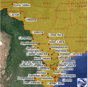
The in-situ measurements are made of two distinct data sets: the hourly measurements collected by 31 stations of the IN-MET network, and the 1 min measurements collected by the INPE network. Figures 1 and 2 show respectively the
Figure 1.Distribution of the 11 INPE stations on the Brazilian ter-ritory.
Figure 2.Distribution of the 31 INMET stations on the Brazilian territory.
tions of the INPE and the INMET stations on a map of Brazil together with names of the administrative regions.
The geographical coordinates of the stations as well as the period of availability of the data are not given here for
the sake of conciseness. They are available in the following pages:
– INPE stations: www.soda-pro.com/help/helioclim/ helioclim-3-validation/brazil-inpe
– INMET stations: www.soda-pro.com/help/helioclim/ helioclim-3-validation/brazil-inmet.
All stations, but one, have measurements spanning more than 1 year from 2005 to 2014, depending on the station.
Prior to the comparison at the hourly summarization, a thorough quality check procedure as recommended by WMO (1981) has been applied on the measurements of the stations. As only the global SSI is available, no consistency check was possible via cross-comparison of the global and its direct and diffuse components. This procedure turned out to be insufficient for these measurements. The test to discard the “not-plausible” values (i.e. ”Extremely Rare Limits” and ”Physical Possible Limits”) was too permissive and too many outliers remained. We have added additional tests based on Gdrywhich is the SSI that should be observed if the sky were
cloud-free with a null turbidity (“dry” sky). Gdry was
com-puted with the ESRA model setting the Linke turbidity factor to 0. We have kept a measurement G only if:
– INMET hourly values: 0.05 Gdry< G < Gdry
– INPE 1 min values: 0.02 Gdry< G < 1.2 Gdry.
Time shift was also observed for several days in the time se-ries of INPE measurements. We decided to discard the mea-surements of a whole day if the time shift exceeds 10 % of the day length.
Remaining INPE 1 min measurements were aggregated to generate hourly irradiation if at least 85 % of the 1 min slots are available and valid. Aggregation is based on a smart av-erage technique that takes into account the sun position at each minute and uses the clearness index.
3.2 Protocol of evaluation
The protocol addressed the comparison of hourly, daily and monthly satellite-based irradiation values against the mea-surements of the 42 stations.
The three satellite-derived databases under concern are de-rived from the MSG imagery, i.e. from images acquired ev-ery 15 min. Satellite estimates need to be aggregated to the hourly time step. This is done in the usual case by summing up the four 15 min values. It may happen that MSG images may have been unavailable. In the creation of HelioClim-3 and CAMS radiation service, the decision had been taken that if at least one image was available in the day, an intelligent interpolation based on the clearness index and taking into ac-count the sun position every minute was applied to synthesize all 15 min irradiation within this day. Such cases are rare and were included in the comparison. Since February 2004, only
84 C. Thomas et al.: Validation of three satellite-derived databases of surface solar radiation
12 days do not have any valid image during the day and as a consequence are missing in the satellite-based databases.
At that step, both estimates and measurements were avail-able at the hourly time step, and the comparison was carried out. First:
– Measurements at night, sunrise and sunset were set to 0, as well as slots when hourly mean of irradiance does not exceed 10 W m−2.
– Estimates were set to “Not a Number” (NaN) when the measurements are missing, and reciprocally. In this way, the data sets contain the same number of data with co-incidence in time.
– For the validation of daily and monthly values, hourly values were aggregated to generate partial daily and monthly sums if at least respectively 65 and 50 % of the hourly slots were available and valid.
Then deviations (estimates−measurements) were computed. In addition to the correlation coefficient, the deviations were summarized by the bias, and the bias relative to the mean of the observation in percent, also named relative bias, and the root mean square error (RMSE), and relative RMSE in percent.
For the sake of conciseness, all results are not provided here. These results are available for three different summa-rizations (hourly, daily and monthly summasumma-rizations) at:
– HC3v4 and HC3v5 validation results for the INMET stations: http://www.soda-pro.com/help/helioclim/ helioclim-3-validation/brazil-inmet
– HC3v4 and HC3v5 validation results for the INPE stations: http://www.soda-pro.com/help/helioclim/ helioclim-3-validation/brazil-inpe
– CAMS radiation service validation results for the INMET stations: http://www.soda-pro.com/help/ cams-radiation-service/validation/brazil-inmet
– CAMS radiation service validation results for the INPE stations: http://www.soda-pro.com/help/ cams-radiation-service/validation/brazil-inpe.
3.3 Validation results: global conclusions
Both INMET and INPE datasets returned consistent results. These results are summarized in the Table 1.
The correlation coefficient is very large for all stations and the three databases, with an average of 0.96. These databases reproduce well the hour from hour changes in SSI. The cor-relation coefficients are similar for the three databases.
HC3v4 shows a tendency to overestimate the SSI: the rel-ative bias ranges from −3 to 13 %, with most values com-prised between 2 and 5 %. HC3v5 exhibits better results with
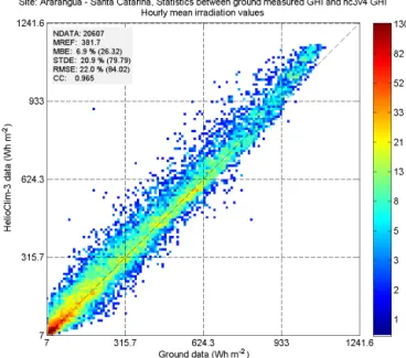
Figure 3. 2-D histogram of HC3v4 versus the hourly data of Ararangua station (INMET).
a smaller bias: between −3 and 7 % and most values be-tween 1 and 3 %. These are very satisfactory results and they demonstrate that HC3v5, and to a lesser extent HC3v4, may be used in studies of long-term changes in SSI in Brazil. The situation is not so good with CAMS radiation service. The relative bias ranges between 2 and 16 % with most values comprised between 5 and 10 %. This fairly large overestima-tion of the SSI by CAMS radiaoverestima-tion service has been noted by Thomas et al. (2016) for stations located in Europe and Africa under different climates. The relative RMSE follows the trend found for relative bias. HC3v5 exhibits the small-est RMSE: from 13 to 31 % with most values comprised be-tween 17 and 23 %. These values are satisfactory for most applications in solar energy domain.
Figures 3, 4 and 5 respectively exhibit the 2-D histogram of HC3v4, HC3v5 and CAMS radiation service versus the hourly measurements for the INMET station of Ararangua. The results are in line with the average values indicated in Table 1, with a relative bias, a relative RMSE and a correla-tion coefficient of:
– 6.9 and 22 % and 0.965 for HC3v4 – 1.6 and 19 % and 0.969 for HC3v5
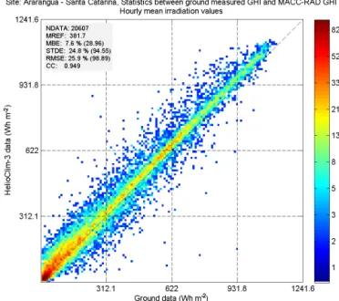
– and 7.6 and 25.9 % and 0.949 for the CAMS radiation service.
The 31 INMET stations are mainly located in the western and the southern part of the country. Even if the global rank-ing of the databases remain unchanged whatever the area, the quality exhibits worse results for the stations located close to the border and on the west like Porto-Velho, Cacoal and
Table 1.Ranges of the performances of HC3v4, HC3v5 and CAMS radiation service for hourly SSI and for all stations (INMET and INPE).
Satellite database Relative bias (%) Relative RMSE (%) Correl. coeff. Min < Av < Max Min < Av < Max Min < Av < Max HC3v4 −3 < 4 < 13 14 < 23 < 33 0.89 < 0.96 < 0.98 HC3v5 −3 < 2 < 7 13 < 20 < 31 0.89 < 0.97 < 0.98 CAMS radiation service 2 < 7 < 16 17 < 27 < 35 0.89 < 0.94 < 0.97
Figure 4.2-D histogram of HC3v5 versus the hourly measurements of Ararangua station (INMET).
Figure 5.2-D histogram of the CAMS radiation service data versus the hourly measurements of Ararangua station (INMET).
Vilhena than for the rest of the stations. Indeed, for respec-tively HC3v5, HC3v4 and CAMS radiation service, the rel-ative bias for these stations is close to 7, 9 and 11 %; the relative RMSE in percent always exceeds 30 %, and the cor-relation is still good but just above 0.9. The main explanation to this trend is that the western part of the country is located on the edge of the MSG coverage. As a consequence, the pixel size in the east-west direction is above 12 km, and as the climate of the Rondônia is tropical with a lot of heavy rains and clouds, the estimation from satellite imagery faces difficulty in modelling accurately the SSI. This was observed by Marie-Joseph et al. (2013) for a similar climate in Guiana. Though the number of stations is low compared to IN-MET, the 11 INPE stations are more equi-distributed on the Brazilian territory. The global ranking of the databases is the same, with HC3v5 in the first position, and HC3v4 in the sec-ond one. A different behaviour of the statistical results can be observed in the north-eastern (NE) area, with the stations of Sao Luiz, Natal and Petrolina, and the south-western (SW) area with the stations of Cuiaba, Campogrande and Chapeco. In NE, the RMSE and correlation values are noticeably bet-ter than in SW, which is in line with the expectations since the stations in NE are closer to the nadir of the satellite and consequently the pixel size is smaller. What was unexpected is the increase of more than 3 % in bias for both HC3v4 and v5, and more than 5 % for CAMS radiation service. This is probably due to the climate of this area, in particular in the coastal areas, where humidity is very high. This tropical area experiences wet and dry seasons, and is known for the heavy rain falls and the high amount of water vapour in the atmo-sphere. Though more work should be devoted to this aspect, a preliminary conclusion is that in this NE area, the estimation of the SSI from satellite imagery is too large likely because the methods Heliosat-2 or -4 do not reproduce accurately the extinction of the radiation by clouds.
4 Conclusions and perspectives
This paper presents an objective comparison of three satellite-derived radiation databases against the measure-ments of 42 stations in Brazil. A great attention has been paid to the quality check procedure of the measurements; by relying on published papers and by completing the procedure adding a few criteria based on clear sky data to discard the remaining outliers.
86 C. Thomas et al.: Validation of three satellite-derived databases of surface solar radiation
Very satisfactory results have been obtained for HC3v5, and to a lesser extent HC3v4. Both may be used in stud-ies of long-term changes in SSI in Brazil. CAMS radiation service is a recent service and is still in infancy. An over-estimation of McClear of approx. 4 % has already been ob-served for the Baseline Surface Radiation Network station of Brasilia (Lefèvre et al., 2013). At least part of the overesti-mation of the CAMS radiation service could be potentially explained by the overestimation of the radiation in clear sky conditions. Further work is needed to confirm or infirm this observation, and also to improve the quality of the CAMS ra-diation service for applications in solar energy. Nevertheless, it is concluded that except for the overestimation by CAMS radiation service, the three databases are suitable for studies of the solar resources in Brazil.
This work is an extension of the validation survey carried out over several BSRN stations located in the Meteosat cov-erage (Thomas et al., 2016). It enables a better knowledge of the capacity of these databases in predicting the SSI. These validation results pave also the way to the geographical ex-tension of the HelioClim-3 database scheduled in 2016–2017 by providing a first insight of the quality in the area covered by both MSG and GOES-East satellites to carry out cross validation.
Acknowledgements. The authors thank the Brazilian company Fotovoltec for providing the measurements of the INPE and INMET stations. The research leading to these results has been partly undertaken within the Task #46 of the Solar Heating and Cooling Implementing Agreement of the International Energy Agency. It has received funding from the French Agency ADEME, research grant no. 1105C0028, and from the European Union’s Horizon 2020 Programme (H2020/2014-2020) under grant agree-ment no. 633081 (MACC-III project). The MACC (Monitoring Atmospheric Composition and Climate) projects are preparatory projects for Europe’s Copernicus Atmosphere Monitoring Service (CAMS).
Edited by: S.-E. Gryning
Reviewed by: two anonymous referees
References
Blanc, P., Gschwind, B., Lefèvre, M., and Wald, L.: The HelioClim project: Surface solar irradiance data for climate applications, Remote Sens., 343–361, 2011.
Blanc, P., Gschwind, B., Lefevre, M., and Wald, L.: Twelve monthly maps of ground albedo parameters derived from MODIS data sets. In Proceedings of IGARSS 2014, 13–18 July 2014, Quebec, Canada, USBKey, 3270–3272, 2014.
Gschwind, B., Ménard, L., Albuisson, M., and Wald, L.: Converting a successful research project into a sustainable service: the case of the SoDa Web service, Environ. Model. Softw., 1555–1561, 2006.
Hoyer-Klick, C., Lefèvre, M., Schroedter-Homscheidt, M., and Wald, L.: User’s guide to the MACC-RAD
Services on solar energy radiation resources, https: //www.gmes-atmosphere.eu/documents/macciii/deliverables/ rad/MACCIII_RAD_DEL_D57.5_final.pdf, March 2015. Lefèvre, M., Oumbe, A., Blanc, P., Espinar, B., Gschwind, B.,
Qu, Z., Wald, L., Schroedter-Homscheidt, M., Hoyer-Klick, C., Arola, A., Benedetti, A., Kaiser, J. W., and Morcrette, J.-J.: Mc-Clear: a new model estimating downwelling solar radiation at ground level in clear-sky conditions, Atmos. Meas. Tech., 6, 2403–2418, doi:10.5194/amt-6-2403-2013, 2013.
Marie-Joseph, I., Linguet, L., Gobinddass, M.-L., and Wald, L.: On the applicability of the Heliosat-2 method to as-sess surface solar irradiance in the Intertropical Convergence Zone, French Guiana, Int. J. Remote Sens., 34, 3012–3027, doi:10.1080/01431161.2012.756598, 2013.
Moussu, G., Diabaté, L., Obrecht, D., and Wald, L.: A method for the mapping of the apparent ground brightness using visible images from geostationary satellites, Int. J. Remote Sens., 10, 1207–1225, 1989.
Oumbe, A., Qu, Z., Blanc, P., Lefèvre, M., Wald, L., and Cros, S.: Decoupling the effects of clear atmosphere and clouds to sim-plify calculations of the broadband solar irradiance at ground level, Geosci. Model Dev., 7, 1661–1669, doi:10.5194/gmd-7-1661-2014, 2014.
Qu, Z.: Modeling radiative transfer in cloudy atmosphere to assess surface solar irradiance (in French), Ph.D thesis, MINES Paris-Tech, 202 pp., 2013.
Qu, Z., Gschwind, B., Lefèvre, M., and Wald, L.: Improving HelioClim-3 estimates of surface solar irradiance using the Mc-Clear clear-sky model and recent advances in atmosphere com-position, Atmos. Meas. Tech., 7, 3927–3933, doi:10.5194/amt-7-3927-2014, 2014.
Remund, J., Wald, L., Lefèvre, M., Ranchin, T., and Page, J.: World-wide Linke turbidity information. Proceedings of ISES Solar World Congress, 16–19 June 2003, Göteborg, Sweden, 2003. Rigollier, C., Bauer, O., and Wald, L.: On the clear sky model of the
4th European Solar Radiation Atlas with respect to the Heliosat method, Sol. Energy, 68, 33–48, 2000.
Rigollier, C., Lefèvre, M., and Wald, L.: The method Heliosat-2 for deriving shortwave solar radiation from satellite images, Sol. Energy, 77, 159–169, 2004.
Thomas, C., Wey, E., Blanc, P., Wald, L., and Lefèvre, M.: Val-idation of HelioClim-3 version 4, HelioClim-3 version 5 and MACC-RAD using 14 BSRN stations, SHC 2015, Istanbul, Turkey, 2–4 December 2015, Energy Procedia, in press, 2016. Wald, L., Albuisson, M., Best, C., Delamare, C., Dumortier, D.,
Gaboardi, E., Hammer, A., Heinemann, D., Kift, R., Kunz, S., Lefèvre, M., Leroy, S., Martinoli, M., Ménard, L., Page, J., Prager, T., Ratto, C., Reise, C., Remund, J., Rimoczi-Paal, A., Van der Goot, E., Vanroy, F., and Webb A.: SoDa: a project for the integration and exploitation of networked solar radiation databases, in: Environmental Communication in the Information Society, edited by: Pillmann, W. and Tochtermann, K., Part 2, 713–720, published by the International Society for Environmen-tal Protection, Vienna, Austria, 2002.
WMO: Technical Note No. 172, WMO-No. 554, World Meteoro-logical Organization, Geneva, Switzerland, 121–123, 1981.