HAL Id: hal-01681558
https://hal.archives-ouvertes.fr/hal-01681558
Submitted on 26 Apr 2018
HAL is a multi-disciplinary open access
archive for the deposit and dissemination of
sci-entific research documents, whether they are
pub-lished or not. The documents may come from
teaching and research institutions in France or
abroad, or from public or private research centers.
L’archive ouverte pluridisciplinaire HAL, est
destinée au dépôt et à la diffusion de documents
scientifiques de niveau recherche, publiés ou non,
émanant des établissements d’enseignement et de
recherche français ou étrangers, des laboratoires
publics ou privés.
Holocene environmental history of a small
Mediterranean island in response to sea-level changes,
climate and human impact
Yoann Poher, Philippe Ponel, Frederic Medail, Valérie Andrieu-Ponel,
Frédéric Guiter
To cite this version:
Yoann Poher, Philippe Ponel, Frederic Medail, Valérie Andrieu-Ponel, Frédéric Guiter. Holocene
envi-ronmental history of a small Mediterranean island in response to sea-level changes, climate and human
impact. Palaeogeography, Palaeoclimatology, Palaeoecology, Elsevier, 2017, 465, Part A, pp.247-263.
�10.1016/j.palaeo.2016.10.037�. �hal-01681558�
1
Holocene environmental history of a small Mediterranean island in response to sea-level
changes, climate and human impact
Yoann Poher
*, Philippe Ponel, Frédéric Médail, Valérie Andrieu-Ponel, Frédéric Guiter
Institut Méditerranéen de Biodiversité et d'Ecologie marine et continentale (IMBE), Aix-Marseille
Université, UMR CNRS IRD Avignon Université, Technopôle Arbois-Méditerranée, Bât. Villemin –
BP 80, F-13545 Aix-en-Provence cedex 04, France
*
Corresponding author
E-mail addresses: [email protected] (Y. Poher), [email protected] (P. Ponel),
[email protected] (F. Médail), [email protected] (V. Andrieu-Ponel),
[email protected] (F. Guiter).
Citation
Poher, Y., et al., Holocene environmental history of a small Mediterranean island in response to sea-level changes, climate and human impact, Palaeogeogr. Palaeoclimatol. Palaeoecol. (2016), http://dx.doi.org/10.1016/j.palaeo.2016.10.037
Highlights
Landscape evolution of a small island is investigated from fossil beetles and pollen. An Erica arborea pasture-woodland initially covered Cavallo Island.
Human activities were involved in the vegetation opening from 4700 cal B.P, onwards. Holocene relative sea-level rise has deeply affected the coastal wetland diversity.
Abstract
The aim of this study is to investigate human-climate-environment interactions in a small Mediterranean island. Comparison between palynological and palaeoentomological data from the Greco pond (Cavallo Island, southern Corsica) reveals that the island was first covered by a more-or-less open Erica arborea pasture-woodland from ca. 7000 to 6100 cal. yr B.P. Grazing animals from 7000 to 6200 cal. yr B.P., followed by a spreading of Ficus carica (marked by the bark beetle Hypoborus ficus) from ca. 6100 to 5750 cal. yr B.P., suggest that human activities could be implicated in the E. arborea forest opening. From
ca. 5500 cal. yr B.P., a regional expansion of Quercus ilex was recorded, but an open landscape with thermophilous and
drought-tolerant plants locally took place from ca. 4700 cal. yr B.P. onward. Pastoral and agricultural biomarkers (pollen, NPP and insect) together with archaeological evidence indicate that human activities were involved in the installation of a lasting open vegetation. Simultaneously, the effects of the Holocene relative sea-level rise on the coastal wetland are recorded: (1) freshwater conditions prevailed in the Greco pond since 7000 cal. yr B.P. at least, (2) the first evidence of salt marsh development dates back to ca. 4500 cal. yr B.P., (3) a strong increase of salinity with marine intrusions were recorded at ca. 3700 cal. yr B.P. while a decline in aquatic insect diversity occurred and (4) a phase of sand dune formation was recorded from
ca. 2000 cal. yr B.P. onward. Our results suggest that if large-scale climatic trend such as the Holocene relative sea-level rise
could affect coastal ecosystem, effects of human activities could play the leading role in vegetation and terrestrial beetle assemblage changes in a small island context.
2
1.
Introduction
During the Holocene, the Mediterranean region was deeply affected by environmental changes resulting from a complex history of human land-use and climatic interactions (e.g., de Beaulieu et al., 2005; Jalut et al., 2009; Roberts et al., 2004; Walsh, 2014). The study of these interactions in insular contexts is pertinent since these marginal territories constitute simplified ecosystems where ecological and species dynamics could be more easily understood (Whittaker and Fernández-Palacios, 2007). For this reason islands are classically considered as ‘laboratories’ for the study of biodiversity structure and dynamics. Islands are also fragile systems, highly vulnerable to rapid environmental changes and anthropic pressure. Since the 1990s, studies based on pollen analysis aiming to reconstruct the impact of human activities and climate changes on Mediterranean islands have increased, but most are focused on large islands such as the Balearic Islands (Burjachs et al., 1994; Yll et al., 1997), Malta (Carroll et al., 2012; Djamali et al., 2012; Gambin et al., 2016), Sardinia (Beffa et al., 2015; Di Rita and Melis, 2013) or Sicily (Noti et al., 2009; Tinner et al., 2009). In Corsica, the vegetation history is quite well known from various palynological analyses carried out on high-altitude sites (Reille, 1975, 1977, 1988a, 1988b; Reille et al., 1997, 1999) and on coastal marshes (Currá et al., 2016; Reille, 1984, 1988b, 1988c, 1992a). These studies highlight the major role of human activities as drivers of vegetation landscape dynamics since the Neolithic period (ca. 7600 cal. yr B.P.). However, small (i.e. <1000 ha) and medium Mediterranean islands are still under-investigated (but see Avramidis et al., 2013; Calò et al., 2013; Pavlopoulos et al., 2010), because holocene sedimentary deposits are rare. For exemple in Corsica little or no information is available about palaeoenvironmental history of the numerous small peripheral islands (c. 145 islands and islets according to Guillemette, 2015) beyond the past few centuries (Vigne, 1994). Yet, these simplified ecosystems are especially suitable to study the complex relationships between environment, sea-level changes and human practices: in general, low-elevation islands are sensitive to sea-level variations whereas small islands could be sensitive to land-use changes (Bass and Dalal-Clayton, 1995).
Despite their small size, some of corsican satellite islands were occupied by Neolithic humans (Agostini, 1978; Vigne, 1994). This is notably the case of the Lavezzi archipelago, located in the 16 km-strait separating Corsica from Sardinia that could have been used as a land bridge, making these islands a potential place of contact for regional civilizations. Moreover, this archipelago surrounded by shallow waters and composed of low-elevation islands, was strongly affected by past sea-level fluctuations. The relative sea-level changes are well-documented in Corsica (De Muro and Orrù, 1998; Laborel et al., 1994; Vacchi et al., 2016a) and could be compared to the regional study of Holocene relative sea-level changes reconstructed in Sardinia (Antonioli et al., 2012; De Muro and Orrù, 1998) or on the Southern France coasts (Laborel et al., 1994; Morhange et al., 2001; Vella and Provensal, 2000), providing a satisfying high-resolution context for NW-Mediterranean chronology and sea-level change (Vacchi et al., 2016b). Among this archipelago, Cavallo Island is therefore in a key position to investigate such issues.
This study is a multidisciplinary analysis of beetle, pollen and non-pollen palynomorph fossil assemblages carried out on a retrodunal sedimentary sequence on the island of Cavallo. Coleopteran species are particularly numerous in the Mediterranean area: more than half of the French beetle fauna is present in Provence (Caillol, 1908; Tronquet ed., 2014). Many species are specific to very narrow ecological niches, they respond quickly to ecosystem shifts and disturbances, and they are relatively easy to identify to species or species-group level. Recent multidisciplinary studies including pollen and coleopteran analyses provide original and independent data concerning forest dynamics, human activities and climate (Ponel et al., 1992, 2001, 2011; Gustavsson et al., 2009; Tessier et al., 1993). This study is the first multidisciplinary analysis including Coleoptera carried out in the Corso-Sardinian region. The main objectives are: (1) to reconstruct the environmental changes on Cavallo Island, (2) to evaluate the respective roles of humans and relative sea-level changes on biodiversity dynamics in a small island context and (3) to compare these results with other Holocene sequences from Corsica, Sardinia and the western Mediterranean area.
3
2.
Study area and archaeological context
The Lavezzi archipelago (Corse-du-Sud, France) is located in the Strait of Bouches-de-Bonifacio between Corsica and Sardinia. The entire archipelago covers approximately 185 ha and it is formed by six main islands with many satellite islets. The distance between Lavezzi islands and the Corsican coast varies from 240 m for the closer island (Piana) (see Fig. 1) to 6 km for the further island (Sperduto, not represented in Fig. 1). Located at 2300 m from the South-East coast of Corsica, Cavallo (41°22′06″N, 9°15′45″E, area: 120 ha, maximum elevation: 32 m a.s.l.,) is the largest of the six islands belonging to the Lavezzi archipelago. The bathymetry around these six islands scarcely reaches 20 m in depth. These islands were part of a land-bridge linking Corsica and Sardinia during the Würmian regression (Conchon, 1976; Van Andel, 1989). Thus, the isolation of Cavallo Island is recent (Fig. 1) and it is believed to have taken place during the early Holocene, probably between 8000 and 5000 cal. yr B.P. (Vigne et al., 1994).
All the Lavezzi islands present similar granitic substrates (monzogranite and granodiorite) lying on a Hercynian bedrock but some of them (Porraggia, Lavezzi and Cavallo) are interspersed by rhyolithic veins (Gauthier, 1984). Natural depressions of clayey-quartzy deposits derived from the erosion of the granitic bedrock have allowed for formation of two permanents water bodies on Cavallo (Greco pond and a small swamp) fed by fresh water sources. They were formerly connected but recent urbanization and earthwork have badly damaged these wetlands and the swamp located at the center of Cavallo was drained during the construction of an airstrip. The Greco pond (1 m a.s.l.) is located in the northern part of the island behind a sand barrier.
The archipelago is characterized by a Mediterranean climate but the wind from the East and the West accentuates the summer drought. Meteorological data from the closest station of Cape Pertusato (Bonifacio) indicate that the mean annual rainfall for the period 1981–2010 is of ca. 542 mm and that the mean annual temperature is of ca. 16.4 °C with an annual temperature range of ca. 8.2 to 27.2 °C (Météo-France, 2010). This data indicates that the area must be included within the thermo-Mediterranean vegetation belt, under a semi-arid bioclimate according to the Emberger's classification (Emberger, 1930).
Since the 1960s, Cavallo Island was the most human-impacted island of the Lavezzi archipelago. Privatized from 1967, the urbanization started around 1970. Before these changes, the island was covered by dense scrublands of Pistacia lentiscus (Gamisans and Paradis, 1992) locally destroyed by man-made fires, favoring pastures and grasslands. Today, Cavallo is still covered by thermo-Mediterranean scrublands dominated by Pistacia lentiscus, Cistus monspeliensis and Juniperus phoenicea subsp. turbinata. Some thermo-xerophilous grasslands induced by goat grazing during the 20th century are still locally present. Dunes are relatively well-preserved, with Pancratium maritimum, Othantus maritimus, Eryngium maritimum and Euphorbia
peplis. The Greco pond is fringed by the most important formation of Tamarix africana of the archipelago and surrounded by
a marshy vegetation, including different species of Juncus and Carex, with a floating mat of Potamogeton pectinatus. Depressions subject to marine influence (salt rising during summer and sea spray) are occupied by halophilous taxa, with
Atriplex prostrata, Salicornia patula, Frankenia laevis and Spergularia div. spp.
Concerning the Coleoptera fauna, the Lavezzi archipelago is relatively well documented. The first inventory (Rungs, 1991) recorded almost 100 Arthropoda species. These results were later compiled by Cocquempot and Rungs (2009) with recent data (Cocquempot and Chambon, 1991; Lanza and Poggesi, 1986; Lemaire, 1992; Orousset, 1995, 2007a, 2007b; Tiberghien et al., 1993). This study brings the number of Arthropoda species known from Lavezzi and Cerbicale Islands to 513, 240 of those being Coleoptera. The most recent investigations carried out in 2014 and 2015 on Cavallo add 43 new beetle species for the island (Médail et al., 2014, 2015). Nevertheless, the entomofauna of Cavallo Island is still not fully studied and the coleopteran communities predating the recent urbanization on Cavallo are unknown.
Several traces of human occupation have been found in the southern part of Corsica representing the Early Neolithic and Middle Neolithic intervals (ca. 8000 to 6000 B.P.) (de Lanfranchi and Weiss, 1972, 1977; Pêche-Quilichini and Bertocco,
4
2009; Vigne, 1992, 2014). The circulation of obsidian during the 4th millennium cal. BC testifies to the existence of socio-economic connections between Corsica and Sardinia (Costa, 2006; Le Bourdonnec et al., 2011). However, the first human presence in the Lavezzi archipelago is believed to have occurred during Chalcolithic time (ca. 4500 B.P.) according to Agostini (1978). Other pieces of pottery and stone tools indicate that the island was also occupied during the Middle Bronze age, the Early Iron age and the Roman period (evidence of a Roman quarry is still visible). Historical documents testify to the occupation of the archipelago during medieval time (Thibault et al., 1987). From the 18th century onward, Lavezzi and Cavallo islands were farmed (10% of pastureland and 15% of arable land on Lavezzi Island) and were grazed by goat cattle from autumn to late spring.
3.
Methods
3.1.
Coring and lithology
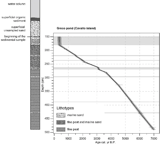
A Russian corer (Ø 5 cm) was used to sample the Greco pond on Cavallo Island in 2014 (41°22′14.8″N, 9°15′47.8″E, 0.48 ha, 1 m.a.s.l.). The water column was about 80 cm and the upper 70 cm consisted of superficial mud deposits and unsampled sand. Thus the core starts 1.5 m under the water surface and reaches 4.9 m depth. The sedimentary profile, CAVA-1 is 3.4 m long (Fig. 2).
3.2.
Insect analysis
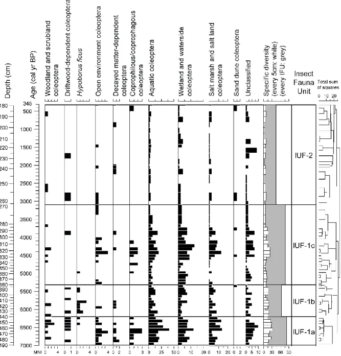
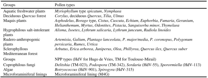
The profile was cut into 70 insect subsamples (each subsample was about 5 cm thick, 38 g and 48 cm³ in volume in average). Insect fossils extraction was carried out using the paraffin flotation method described by Coope (1986) over a 300 µm sieve. Identifications were made by direct comparison with specimens from a modern reference collection. The minimal number of individuals (MNI) for each taxon is estimated by counting diagnostic elements of exoskeleton. The term “taxa” refers to all fossils identified at any taxonomic levels (species, genus, family). Since Coleoptera macrofossils were abundant and well preserved, only this order is taken into account in the analysis and the interpretations. Nomenclature and taxonomic order follow Tronquet (2014). The palaeoecological interpretation of beetle assemblages is based on geographical distributions and biotic features described in modern literature (Balachowsky, 1949; Caillol, 1908; Coiffait, 1984; Constantin and Liberti, 2011; Delobel and Delobel, 2003; Delobel and Tran, 1993; Guignot, 1947; Hoffman, 1950, 1954, 1958; Jeannel, 1941, 1942; Koch, 1989a, 1989b, 1992; Paulian and Baraud, 1982; Saint-Claire Deville, 1914; Soldati and Coache, 2005; Thérond, 1975). Coleoptera taxa were grouped into ecological categories according to their ecological affinities or their preferred biotopes (described in Table 1) and presented on a synthetic histogram (Fig. 3) drawn with C2 software (Juggins, 2007).
Insect Fauna Units (IFU) were established using hierarchical agglomerative cluster analysis (the dissimilarity matrix was calculated using Bray-Curtis distance) with the R 2.13.2 software (R Development Core Team, 2011) and Bray-Curtis distance was computed with ‘rioja’ R package (Juggins, 2012). The more parsimonious number of biozone (IFU-1 and IFU-2) was established using a broken-stick model (Bennet, 1996) with the Connis model (Grimm, 1987). We sub-divided IFU-1 into 3 under-units (IFU-1a, IFU-1b and IFU-1c) on the basis of changes in entomological assemblages (Fig. 3).
3.3.
Pollen and non-pollen palynomorph analyses
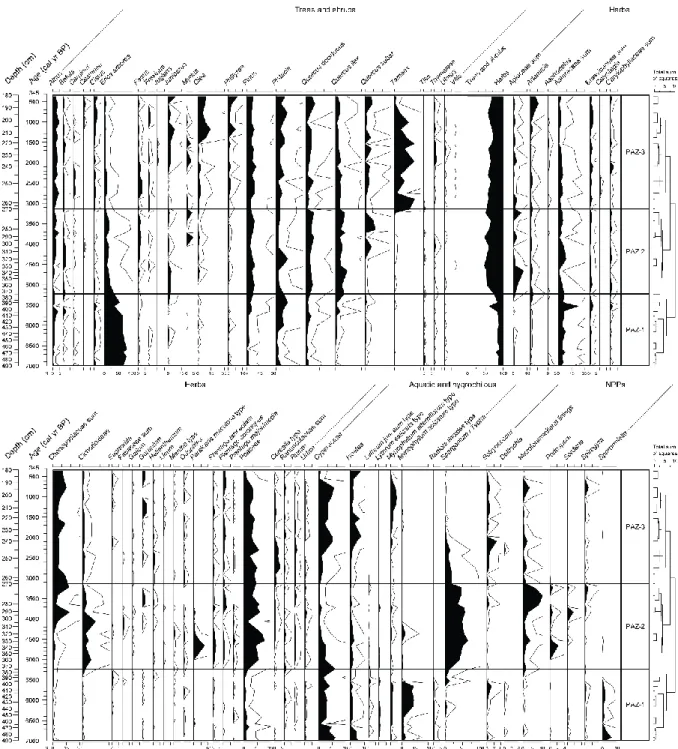
The sediment core was sampled every 1 cm (sandy layers were not sampled) for pollen and non-pollen palynomorph (NPP) analyses. Thirty-eight subsamples of circa 2 cm³ were prepared using the standard method described by Faegri and Iversen (1989). Pollen and NPP counts were performed using a Leica microscope at ×500 magnification oil immersion. Identifications were made with standard atlases and keys (Beug, 2004; Reille, 1992b; Van Geel, 2001). A minimum of 300 pollen grains per sample were counted; beyond this number, only new pollen types were counted (Table S1, published online as supplementary material). Pollen data are represented in percentages of total pollen sum excluding Cyperaceae,
Sparganium-Typha type, fern spores, algae, microforaminiferal linings and aquatic plants (e.g., Myriophyllum type spicatum, M. type alterniflorum). NPP are expressed in concentrations of spores or elements per grams. Pollen and NPP are presented on a
5
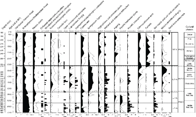
synthetic diagram (Fig. 4) drawn with C2 software. Pollen Assemblage Zones (PAZ) were established using hierarchical agglomerative cluster analysis (Bray-Curtis distance) with the R 2.13.2 software (Fig. 4). To facilitate cross-comparison with insect data, pollen and NPP are also grouped into summary curves according to their local ecological affinities (Reille, 1992a; Gamisans, 1999) or their value as indicators of anthropogenic impact (Behre, 1981; Baker et al., 2013) (Table 2) and presented on a synthetic diagram (Fig. 5).
3.4.
Radiocarbon data
The chronology of CAVA-1 is based on six AMS radiocarbon measurements (Table 3) performed on bulk peat sediment samples (1 cm thick) by the Poznań radiocarbon Laboratory (Rubież, Poland). We calibrated the ages and created an interpolated age-depth model with the “CLAM” R package (Blaauw, 2010) of R 2.13.2 software. The fine sand layers intercalated in the peat profile (probably corresponding to almost-immediate aeolian deposits) were not taken into account in the age-depth modeling (Fig. 2).
4.
Changes in beetle assemblages
A total of 2039 fragments of Arthropod fossils were identified, corresponding to 144 taxa among which 133 taxa are Coleoptera (Table S2, published online as supplementary material). Other taxa include Heteroptera, Hymenoptera (Formicidae) and Araneae orders. In this study, 39% of Coleoptera were identified to species level, 48% to the genus and 13% to higher taxonomic level. Within the Coleoptera, the most represented families are Staphylinidae (17%), Curculionidae and Dytiscidae (11%), Harpalidae (8%), Hydrophilidae and Scarabeidae (6%), other families represent <5% of Coleoptera fauna. Abundance patterns mirrored those of taxa richness since there is a high correlation coefficient between the number of taxa and abundance in each sample (r = 0.956; P < 0.00001; n = 70). An average of 11 beetle taxa and 16 minimal number of individuals (MNI) are recorded per sample which is low in comparison with previous entomological studies in archaeological or palaeological context (e.g., Coope and Elias 2000; Ponel et al. 1992, 2000, 2007) but quite high considering the initial volume of sediment analysed. Indeed, the number of individuals/100 g varies from 0 to 188 which is in the norm of the studies cited above (Table S2, published online as supplementary material). Furthermore, the good taxonomic resolution and the existence of many stenotopic beetle taxa with narrow ecological requirements are relevant to reconstruct biodiversity and environmental changes with accuracy. On the basis of the four biozones (IFU-1a, IFU-1b, IFU-1c and IFU-2), it is possible to describe beetle assemblage changes and to propose palaeoecological interpretations for each chronologically-constrained biozone (Fig. 3):
4.1.
IFU-1a, a diversified insect fauna in a wooded island (490–440 cm; 6993–6200 cal. yr B.P.)
The richest beetle assemblage is identified in this lowermost/oldest biozone (Fig. 3). This assemblage is dominated by aquatic beetles, and beetles living on wetland margins (respectively 28 and 15 taxa). Three aquatic beetles living exclusively in standing or slowlyrunning freshwater are almost restricted to this biozone: Hydrochus, Helochares and Limnebius. Several characteristic aquatic taxa living in lacustrine or swampy environment are recorded, such as Agabus bipustulatus, Colymbetes
fuscus, Ochthebius, Berosus, Enochrus or Noterus. Aquatic beetle assemblages also include halotolerant species which can live
in brackish water or saltmarsh as Hygrotus parallellogrammus, Hydrobius fuscipes or Limnoxenus niger. The record of
Canthydrus diophthalmus is remarkable since this Ethiopian species is known in Europe only in the Iberian Peninsula, and has
never been recorded in Corsica nor France (Millán et al., 2005; Montes and Soler, 1985). The ecology of this Noteridae is not well known but it seems that it occurs in shallow water with a certain degree of eutrophication and fine organic particles (I. Ribera, pers. comm.). The rich riparian beetle fauna including Contacyphon, Paratachys bistriatus, Ocydromus, Phalacrus,
Bagous or Hylobius transversovittatus attests that this wetland was bordered by a rich and abundant hygrophilous flora. Species
belonging to the genus Bagous live on different aquatic plants: Potamogetonaceae, Lemnaceae, Lentibulariaceae, Equisetaceae, Typhaceae, Cyperaceae and Frankeniaceae on coastal environment. The larva of Hylobius transversovittatus lives and overwinters in the ligneous roots of Lythrum salicaria while the adult is found on wet margins of swamps. The Greco pond
6
and the former central marsh were probably connected during the deposition of IFU-1a, in the form of a wide central wetland with a permanent fresh water body and swampy margins covered by an abundant hygrophilous vegetation. During this period, salt meadows or brackish water bodies were probably present as indicated by halophilous Caraboidea such as Pterostichus
cursor or halotolerant such as Bembidion octomaculatum. However, the sea line was probably far away and the marine
influence was very low.
The remaining part of Cavallo Island was probably covered by a ligneous vegetation, enabling a rich phytophagous and xylophagous beetle fauna to establish, with Scobicia chevrieri, S. pustulata, Agrilus and Berginus tamarisci. The two first species live in dead wood of various ligneous species such as Ficus carica (common fig tree), Tamarix or Vitis (vine). Most of the species belonging to the genus Agrilus are associated with Fagaceae, Salicaceae and to a lesser extent, Rosaceae. Adults of
Berginus tamarisci are found on trees (Pinus, Tamarix), on shrubs (Crataegus, Clematis) but also on Genista scorpius and Spartium junceum. Several specimens of Aphanommata filum and Mesites pallidipennis both associated to driftwood suggest
that the shoreline displayed some accumulations of drift wood. These wood debris could originate from the local vegetation but may also have been brought by the sea from distant trees. Some occurrences of open-ground beetles are recorded suggesting that open environments must have been present in the immediate vicinity (Fig. 3): Pachybrachis cf. rugifer, a thermophilous species living on Lamiaceae (Thymus sp., Satureja montana, Rosmarinus spp.); Apion or Tychius both associated to various herbaceous plants such as Trifolium and Medicago, and one taxa belonging to the Bruchinae subfamily whose larva are mostly associated to Fabaceae seeds. IFU-1a also contains a coprophagous beetle fauna usually living on grassland and grazed land, with Aphodius, Euoniticellus, Onthophagus taurus and O. vacca. This strongly suggests that Cavallo Island was grazed by wild animals or cattle.
4.2.
IFU-1b, a first beetle fauna impoverishment (440–380 cm; 6200–5311 cal. yr B.P.)
This short period corresponds to a change in beetle assemblage composition. This less diversified biozone with 58 beetle taxa, includes 12 taxa present nowhere else in the profile. Aquatic beetles and beetles living on wetland margins show a slight decrease of both diversity and MNI but remain dominant (respectively 24 and 12 taxa, see Fig. 3). Some taxa were already recorded in the lowermost IUF, such as Bagous, Colymbetes fuscus, Hygrotus parallellogrammus, Ochthebius, Berosus,
Enochrus, Limnoxenus niger, Noterus but two new species are found for the first time: Phytobius leucogaster and Hyphydrus aubei. Adults of Phytobius leucogaster live in ponds and swamps on Myriophyllum whereas Hyphydrus aubei is a halotolerant
water beetle, living in muddy standing water with dead leaves on the bottom but also in brackish water. Among the newly recorded hygrophilous beetles are Acupalpus cf. elegans, Dyschirius, Bledius and Protapalochrus flavolimbatus. Acupalpus
elegans, is a riparian halophilous species occurring on salt meadows along the shore or inland. Many species belonging to the
genus Dyschirius are halophilous, they are found along with Bledius on salty sandy clay (1.5 to 3‰ of marine salt) covered by Chenopodiaceae. Protapalochrus flavolimbatus lives on Typha latifolia, Phragmites communis (common reed grass) and
Juncus where adults and larvae hunt other insects living inside reed tubes. As a whole, the freshwater wetland fauna was
certainly not markedly different in the IFU-1b in comparison with the IFU-1a. Even if the aquatic beetles are slightly less diversified than before with more halotolerant/halophilous elements, the fauna is still characteristic of permanent ponds. Around these ponds, the vegetation was probably dominated by emergent and aquatic macrophytes (Protapalochrus
flavolimbatus is the best indicator of this). Continuous records of halotolerant aquatic taxa such as Hygrotus parallellogrammus, Ochthebius and Limnoxenus niger still suggest that moderately saline habitats may have been available from time to time in
the immediate vicinity.In this faunal unit, open-environment beetles are scarce (Bruchidius and Aspidapion aeneum only) while coprophagous/coprophilous beetles disappear completely (Fig. 3). An important faunal change also affects the woodland/scrubland taxa group: most of the beetle species previously recorded are replaced by new ones. New characteristic elements include Sulcacis fronticornis which lives on Polyporaceae, especially Trametes versicolor and Lenzites betulinus associated with broadleaved trees; Phloeotribus cf. scarabaeoides which digs galleries in Oleaceae wood (mainly Olea
7
branches of Spartium junceum; and Triodonta cf. cribellata a Corso-Sardinian endemic species living on riparian shrubs.
Hypoborus ficus which almost-exclusively dominates the xylophagous fauna, is the only element in common between IFU-1a
and IFU-1b (Fig. 3). This bark beetle digs galleries in common fig tree (Ficus carica) branches and follows the geographical range of its host plant in the Mediterranean region. The common fig tree probably occupied an important place in the landscape, this supports the hypothesis of its native status in the western Mediterranean Basin. In spite of the occurrence of two new taxa (Amaurorhinus cf. bewickianus/sardous and Pselactus spadix), the driftwood fauna is reduced, suggesting that the amount of dead wood deposited on the beach was less abundant, compared to IFU-1a.
4.3.
IFU-1c: a disturbed wetland in an open landscape (with grazing practice) (380–269 cm; 5311–
3090 cal. yr B.P.)
Within this unit, the coleopteran fauna shows a temporary increase of diversity with 70 identified taxa. Three main events mark this zone: an impoverishment in the aquatic beetle fauna, a strong decrease in beetle indicators of woodland/scrubland and the return of dung-dependent beetles associated with open land beetles in the middle of this IFU (Fig. 3).
At the beginning of the period, the hygrophilous fauna still dominates the beetle assemblages (19 taxa) but the aquatic fauna strongly decreases (falling from 24 to 18 taxa) with the disappearance of e.g., Cybister, Hydroglyphus geminus and
Limnebius. All the common aquatic beetles recorded in this unit (Bagous, Enochrus, Hygrotus, Limnoxenus niger, Ochthebius, Noterus) present similar patterns of abundance: they simultaneously disappear (or decline) at the beginning of the period (about ca. 5300 to 4600 cal. yr B.P.), then they become more abundant from ca. 4600 to 3700 cal. yr B.P. and finally disappear anew
from ca. 3700 to 3100 cal. yr B.P. (Fig. 3). This transitory wetland fauna expansion in the middle of the IFU-1c, within a global unfavorable period suggests an environmental instability of wetlands which will be discussed in the light of other indicators, such as pollen and NPP. Among all these marshy taxa characteristic of standing water, the occurrence of Esolus (represented by a single macrofossil) is unexpected. This riffle beetle is associated with rapid streams and rivers with a rocky bottom, but there is currently no river network on Cavallo Island. The presence of Esolus could be due to a distant transport, but it is possible that small temporary tributaries existed at that time, during wettest period. Hygrophilous beetles living on wetland margins diversified during this period with 7 new taxa, including Oodes gracilis a subaquatic Harpalidae living in wetland with abundant vegetation, and several hygrophilous rove beetles occurring under plant debris, such as Lathrobium, Mycetoporus and Ochthephilum brevipenne, a halophilous species. All these damp ground taxa indicate that the substratum was enriched in plant debris. The presence of aquatic halotolerant beetles previously recorded, Ochthephilum brevipenne and Pterostichus
cursor (whose occurrences increases from the middle of IFU-1c) indicate that meadows or brackish water bodies were probably
extended during this period.
A new beetle indicator of sand dune environments occurs in this fauna unit (Fig. 3). The isolated occurrences of two flightless psammophilous species – Catomus consentaneus and Pimelia cf. angusticollis/payraudi (already recorded at the very end of the IFU-1b) – suggest that sand dunes were present in the immediate vicinity of the deposit site. Most of the Coleoptera indicators of woodland/scrubland disappear. Open ground beetles become diversified again with taxa previously recorded (Apion, Aspidapion aeneum and Bruchinae) and first appearance of others (Gymnetron and Pedinus meridianus). The palaeoenvironment of the island was certainly a vast open land, covered by an abundant herbaceous flora since Aspidapion
aeneum larvae develop in stems of various Malvaceae such as Althaea and Malva whereas Gymnetron larvae live on stems,
leaves, roots and flowers of some Scrophulariaceae and Plantaginaceae. Pedinus meridianus is also a good open ground indicator since this thermophilous species is associated with open and dry environments. In IFU-1c, the dung-dependent fauna is less abundant but more diversified than in the IFU-1a, with coprophilous Staphylinidae (Oxytelus piceus) and coprophagous Scarabaeideae (Aphodius, Caccobius schreberi, Euoniticellus, Onthophagus verticicornis, O. gr ovatus, O. taurus). This assemblage clearly suggests that grazing animals were again present locally, mainly between ca. 5000 and 4100 cal. yr B.P.
8
4.4.
IFU-2: overall impoverishment of the beetle fauna (269–150 cm; 3090–345 cal. yr B.P.)
The insect unit IFU-2 is marked by a simultaneous decline of all former ecological categories, both MNI and species diversity (77 beetles taxa were identified in the 22 samples of IFU-1c but only 38 beetle taxa in the 25 samples of IFU-2). The species diversity does not exceed 17 taxa per sample (Fig. 3). The impoverishment of beetle assemblages is particularly visible in the aquatic beetle assemblages since only the most widespread standing water taxa persist (e.g., Bagous, Ochthebius or
Berosus). Other aquatic beetles are occasionally recorded: Colymbetes fuscus, Cybister, Hygrotus parallellogrammus, Enochrus, Limnoxenus niger and Noterus. The hygrophilous beetle fauna is affected by the same impoverishment since it is
represented only by 4 Caraboidea (Dyschirius, Ocydromus, Bembidion articulatum, B. octomaculatum) and 6 Staphylinidae (Bledius sp., B. unicornis, Carpelimus, Pselaphinae, Stenus, Tachyporus). Even Contacyphon, a ubiquitous widespread wetland taxa, rapidly disappears at the beginning of IFU-2. Such impoverished assemblages could result from unfavorable taphonomic conditions since there is a lithological change in CAVA-1 during this unit (transition from fine peat to peat mixed with marine sand, see Fig. 2). The sand dune influence is suggested by three psammophilous taxa (Catomus consentaneus, Platytomus
laevistriatus and Psammodius) living buried in the sand dune at the roots of psammophytes. However, the global decline in
insect diversity occurs at the end of the IFU-1c (from ca. 3700 cal. yr B.P.), within a homogenous sedimentary unit. Thus, the disappearance of many aquatic and hygrophilous beetles before any lithological change clearly indicates an increase of salinity in the Greco pond.
From insect data, the last 3100 years provide little information regarding the evolution of the landscape on Cavallo Island. Woodland and scrubland indicators are almost-totally absent in IFU-2 and it is likely that dry and open-land or low scrubland prevailed at that time. Nevertheless, such impoverished assemblages do not enable to establish a solid palaecoecologic reconstruction. The upper part of the sedimentary profile (150–180 cm) is exclusively made of sand, which corresponds to the base of the current sand-barrier separating the Greco pond from the sea. These first 30 cm contain 15 arthropod taxa probably reworked in the sand deposits, they are not represented in the insect diagram.
5.
Changes in sporo-pollinic assemblages
5.1.
PAZ-1 (375–490 cm; 6993–5235 cal. yr B.P.), the mid-Holocene dominance of Erica arborea?
The lowermost/oldest pollen assemblage zone spans the whole IFU-1a and IFU-1b. This zone is characterized by an optimum of Erica arborea (up to 80%) which exists from the beginning of the sequence with frequencies above 60% (Fig. 4). According to the modern pollen-rain/vegetation relationships described by Reille (1992a), the low frequencies of Quercus ilex (<5%) compared to high percentages of E. arborea indicates that Q. ilex did not play any part in the local or regional vegetation. This reflects the dominance of E. arborea forests during this period on Cavallo Island. The 14C dates of this study and previous
palaeobotanical data (Reille, 1975) enable us to confidently attribute PAZ-1 to the Atlantic period (from ca. 8000 to 5000 cal. yr B.P.).
Low frequencies of deciduous Quercus and Quercus suber (both <6%) but also sporadic records of Tilia, Fagus and
Carpinus correspond to a long-distance signal. Pinus laricio, a major pollen producer, is only recorded in low frequencies
(<5%) indicating that the representation of this taxa results also from long-distance transport from higher elevation in southern Corsica. With the exception of Erica arborea, some other plants characterizing the thermo-Mediterranean belt such as
Juniperus (probably J. turbinata), Pistacia or Phillyrea (respectively 1, 5 and 1%) are scarcely recorded before 6000 cal. yr
B.P. while Myrtus is almost absent. Apart from Asteroideae (6% on average), other herbaceous plants show low frequencies: Chenopodiaceae (1%), Poaceae (3%), Cichorioideae (>1%). From ca. 7000 to 5500 cal. yr B.P., low frequencies of anthropogenic pollen indicators (<2%, see Fig. 5) and coprophilous fungi concentration (Sporormiella >3000 spores/g,
Delitschia till 240 spores/g) suggest that if pastoral practices occurred on Cavallo Island during Neolithic time, they were
moderate. From ca. 6200 to 5500 cal. yr B.P., the representation of both aquatic and wetland plants is optimal while other riparian plants such as Cyperaceae remain stable, around 10%. Among paludicolous and aquatic plants, Alisma (<1%), Radiola
9
type linearis (1%), Lythrum type junceum (2%), L. type salicaria (<1%) and Myriophyllum type spicatum (14%) indicate that when Greco pond was formerly connected to the central pond, both were predominantly occupied by fresh water, with little or no marine influence (Fig. 4).
However, the end of this period provides evidence for an increase in salinity in the Greco pond. This is suggested by the increase of microforaminiferal concentrations from <600 to 1783 linings/g, the disappearance of Radiola type linearis and the reduction of Myriophyllum type spicatum. The end of PAZ-1 is also characterized by a decrease in frequencies of Erica arborea (65 to 36%), an increase of Quercus ilex (1 to 10%) and Pistacia (till 13%).
5.2.
PAZ-2 (375–266 cm; 5235–3138 cal. yr B.P.), decline of Erica arborea and development of
open-landscape
The pollen zone PAZ-2 spans almost exactly the IFU-1c. The decline of Erica arborea (35 to 6%) and the reduced rate of increase of Quercus ilex (to 14%) place the entire PAZ-2 in the Sub-boreal period (from ca. 5000 to 3000-2500 cal. yr B.P.) described classically in Corsica (Reille et al., 1999). The expansion of Fagus in the Incudine massif (50 km from Cavallo) described by Reille (1975) and Reille et al. (1999) at the same period, is here recorded by frequencies reaching 2%.
During the Sub-boreal, the major consequence of the degradation of E. arborea was the expansion of Q. ilex in Corsica. On coastal zones, another consequence was the increase of a thermophilous vegetation (Reille, 1975, 1984, 1988b, 1992a). On Cavallo Island, the expansion of this thermophilous vegetation seems to be modest: Pistacia frequency is about 4%, Olea,
Juniperus, and Phillyrea show a continuous curve starting from ca. 4700 cal. yr B.P., whereas Myrtus occurs later, from ca.
3800 cal. yr B.P. (Fig. 4). In contrast to this, the increase of Poaceae (up to 24%), Cichorioideae (15%), Apiaceae (7%) and anthropogenic pollen indicators (up to 14%) suggest that the opening of E. arborea stands benefited these thermo-xerophilous herbs. From ca. 4700 cal. yr B.P., the continuous curve of Cerealia-type and the peak of coprophilous fungi (Sordaria till 17000 spores/g, Podospora >20,000 spores/g) indicate that agriculture and pastoral practices could probably be accountable for these major vegetation changes. At the same date, a short but significant increase of Persicaria maculosa (up to 7%) is also an indicator of these anthropogenic practices. This hygrophilous plant lives in anthropogenically and naturally disturbed habitats such as meadows and fields, but also occurs on the margins of lowland ponds and rivers (Simmonds, 1945).
A decrease of both aquatic and paludicolous plants (in particular the disappearance of Myriophyllym type spicatum and
Radiola type linearis), a strong increase in Chenopodiaceae frequencies (probably halophilous species of salt grounds) and a
rise of microforaminiferal linings concentrations along the period (to 10,080 linings/g) are simultaneously recorded. Many Chenopodiaceae taxa are halophytes (Grigore and Toma, 2007) and the increase of Chenopodiaceae in Mediterranean coastal context has already been used as a salt marsh indicator by Court-Picon et al. (2010) on the Lion gulf (southern France) or in other coastal sites in Italy (Di Rita et al., 2011; Di Rita and Melis, 2013). On Cavallo Island, the conjunction with relatively high value of Chenopodiaceae and microforams is also interpreted as a growing salinity indicator suggesting the transition from a freshwater to a brackish water environment.
Among riparian plants, Cyperaceae declines (19 to 1%) while the increase of Sparganium-Typha frequencies (>50%) reveals the expansion of the community of reed beds. In Corsica, the genus Sparganium is only represented by S. erectum and
S. minimum, two salt-intolerant species both absent from the Cavallo flora today (Médail et al., 2014, 2015). Among the
Typhaceae taxa that exist in Corsica, only Typha latifolia is present today on the Island. Cattails are known to occur in a wide range of habitats, from mineral-poor to mineral-rich soils and tolerate many levels of salinity (Smith 1986) but T. latifolia, in particular, is considered halotolerant and is able to quickly colonize disturbed areas (Stewart et al., 1997).
10
5.3.
PAZ-3 (266–150 cm; 3138–345 cal. yr B.P.), the late-Holocene establishment of an
anthropogenic landscape
The uppermost zone PAZ-3 spans exactly the last insect unit IFU-2. The low optimum of Fagus (almost 3%) dated to ca. 2700 cal. yr B.P. following a relative decline of deciduous Quercus and Quercus suber (from 9 to <5%) constitutes an unambiguous indication that the PAZ-3 corresponds to the Subatlantic period (from ca. 3000–2500 cal. yr B.P. to the present) described classically by palynologists. During all of the PAZ-3, the decline of Erica arborea continues (5%) and more thermophilous shrubs [Cistus (3%), Juniperus (5%), Myrtus (3%), Pistacia (13%), Thymelaea (2%)] seem to take advantage of increased human influence. However, herbaceous vegetation still dominated the landscape of Cavallo Island: Poaceae (around >8%) and anthropogenic pollen indicators (up to 8%, see Fig. 5). From ca. 2700 to 2300 cal. yr B.P., pollen records show evidence of important cultivation practices since the frequencies of Cerealia-type reach 4%. The near-absence of coprophilous fungi during PAZ-3 suggests that pastoral practices were extremely reduced during this period. At ca. 2000 cal. yr B.P., first occurrences of Juglans following at ca. 1000 cal. yr B.P. by Castanea indicate the expansion of these cultivated trees in Corsica from the Roman Period and during the Medieval Period. Simultaneously, the curve of Juniperus (up to 5%) indicates that juniper shrubs (probably the coastal Juniperus turbinata) occupied a sizeable place in the landscape of Cavallo during the last 2000 cal. yr B.P.
The pollen zone is also marked by a substantial increase of Tamarix which frequencies reach 23% with a transitory decline from ca. 2700 to 2300 cal. yr B.P. This pollen type probably belongs to Tamarix africana, the widespread species of the genus in Corsica (Gamisans, 1999) and the only Tamarix species currently present on Cavallo Island. According to a modern pollen rain study of Tamarix africana (Triat, 1971), such frequencies attest to the local presence of this tree. Currently Tamarix
africana occurs in various environments: on the margins of estuaries, temporary ponds, salt meadows with Juncus maritimus,
red beds margins, in mosaic with Salicornia or on salt marshes margins. In most of these situations, T. africana is a pioneer tree, in poorly-vegetated areas because of the salinity of substratum (Paradis et al., 2013). The expansion of Tamarix matches the decrease of Sparganium-Typha (19 to <1%) and of the microforaminiferal linings concentrations (an average of 853 linings/g). At the end of PAZ-3, pollen records suggest more pronounced freshwater conditions on Cavallo wetlands: percentages of Isoetes and Cyperaceae increase (respectively from <1 to 8% and from 2 to >10%) while pollen of Alisma and
Myriophyllum type spicatum occur again.
6.
The palaeoenvironment history of Cavallo Island inferred from Coleoptera, pollen and
NPP cross-comparisons
Palaeoentomological studies have already demonstrated that insect remains in a deposit are not necessarily related to the immediate surrounding area (Kenward, 1975, 1976), that insect macrofossils could undergo important taphonomical problems (Kenward, 1976; Ponel et al., 2011) and that deposition of dead beetles from far-afield by wind and water could lead to the formation of complex fossil assemblages, difficult to interpret (Ponel and Richoux, 1997). Beetle taxa were regularly represented by a single occurrence in the sediment core CAVA-1. With such low abundances, it becomes difficult to establish whether insect number fluctuations are due to preservation conditions, random inclusions, catchment changes, or environmental changes. The beetle data alone should be interpreted with caution – and therefore compared with pollen data. Previous multi-proxy studies have demonstrated a good agreement between both records (e.g., Hughes et al., 2000; Ponel et al., 2001, 2014): monophagous or oligophagous beetles may confirm the local presence of plant taxa (e.g., Phytobius leucogaster) or reveal the presence of plant not indicated in the pollen record (e.g., Ficus carica), and both proxy may provide original information concerning local past human activities (e.g., dung dependent beetles and coprophilous spores).
The small surface of Cavallo (only 120 ha), its restricted catchment area (with a higher elevation of 32 m a.s.l.) and its relative isolation from Corsica mainland lead to reduce both the overrepresentation of pollen grains from the regional vegetation and inward influx of allochtonous beetles. In the Cavallo profile, the chronological boundaries of insect fauna units (IFU) and
11
pollen assemblages zones (PAZ) are almost identical. Such an agreement suggests that environmental changes on Cavallo during the last 7000 years have influenced vegetation structure and insect diversity simultaneously and in the same way (Fig. 5).
6.1.
7000 to 5500 cal. yr B.P.: rise and fall of Erica arborea, the end of a forested landscape?
Nowadays in Corsica, Erica arborea forms a more-or-less dense maquis strongly shaped by fires and humans, hardly exceeding 2–3 m in height, between the thermo- and supra-Mediterranean vegetation belts (Gamisans, 1999). However, this plant is able to reach 20 m in height in some forests in Madeira (Press and Short, 1994) or La Gomera (Arco Aguilar, 2006). Palaeoecological analyses showed that the latter experienced little transformations since the last ca. 5500 cal. yr B.P. and that the Erica woody heath did not suffer important human impacts since they settled between ca. 3100 and 1800 cal. years ago (Nogué et al., 2013). This raises the question of the potential vegetation at low and medium altitudes in Corsica and Sardinia before human impacts, and if Erica arborea also formed forests as suggested by palynological studies (Beffa et al., 2015; Reille, 1992a; Reille et al., 1999), or tall scrublands. On Cavallo Island, pollen data suggest that the landscape was dominated by Erica arborea (Fig. 4) between ca. 7000 and 5800 cal. yr B.P. (PAZ-1 and IFU-1a). Despite a high percentage of Erica
arborea (>70%) during the period ca. 7000–6200 cal. yr B.P., continuous curves of Cistus and Asteroideae suggest the
existence of low scrublands and grasslands in the heather vegetation. This feature is similar to other coastal pollen sites in Corsica (Reille, 1984, 1988b, 1992a). This highlights the limits of pollen analysis alone to reconstruct the structure and the state of maturity of the woody vegetation: was it composed of relatively low Erica shrubs or old trees and decaying trunks in a mature forest with a notable amount of dead wood? As emphasized by Ponel (1995) and Ponel et al. (1992, 2001), fossil beetles could help to answer this difficult question. Concerning Cavallo Island, the saproxylic beetles recorded during the maximum of Erica arborea frequencies could bring part of an answer (Fig. 5). Driftwood-dependent beetles occurring from
ca. 7000 to 6000 cal. yr B.P. (Aphanommata filum, Mesites pallidipennis and Pselactus spadix) are stenotopic species that need
pieces of wood and trunks deposited on the beaches by the waves (Hoffman, 1954). If we suppose that some of this material may originate from local vegetation, then this suggests that Erica arborea stands could be represented by a forest or high-scrubland with well-developed trunks. Even if wood debris could have been brought by the sea from a distant source, we consider this as indirect evidence that Erica arborea could form tree plants at low altitude in Corsica during the Atlantic period. On Cavallo Island, coprophilous beetles also indicate open and grazing conditions suggesting that Erica arborea was present in the form of a more-or-less open pasture-woodland (or pasture-tall scrubland).
From ca. 6100–6000 cal. yr B.P. (end of PAZ-1 and IFU-1b), rarefaction of woodland/scrubland and driftwood-dependent beetle taxa (Fig. 5) probably marks the first hint of the E. arborea forest regression, even if pollen frequencies remain stable until ca. 5800 cal. yr B.P. Reille (1992a) suggests that clearance of E. arborea could be hidden by its important pollen dispersal. The gap between saproxylic beetles rarefaction at 6000 cal. yr B.P. and Erica arborea pollen decline 200 years latter could be the result of a pollen dispersion artefact. This hypothesis was reinforced by the continuous beetle record of Hypoborus ficus from ca. 6100 to 5800 cal. yr B.P. which indicates local establishment of Ficus carica. The common fig tree is a native plant domesticated early in the Mediterranean basin during Neolithic times (8000–7000 B.P.; Zohary and Hopf, 2000) and seeds were already found in association with cereals in archaeological remains in Sicily (Leighton, 1999) or Sardinia (Ucchesu et al., 2015). The genetic structure of Mediterranean populations of Ficus carica, suggests an ancient origin of this tree in the West Mediterranean before domestication (Khadari et al., 2005). But in Corsica, Khadari et al. (2005) proposed an intermediate situation where the common fig tree probably results from a mixture of ancient local natural populations with recent human introductions. Thus, even if native Ficus populations could have been present at this period on Cavallo, we cannot exclude the hypothesis that the common fig tree could have also been favored by agro-pastoral activities. Such a local expansion of Ficus carica following grazing evidence suggests that Erica arborea did not exclusively dominate the vegetation from ca. 6100 cal. yr B.P. onward. Furthermore, the rarefaction of Hypoborus ficus from ca. 5800 cal. yr B.P. (certainly resulting from
Ficus carica decline) corresponds to an increase in Asteroideae, in Pistacia frequencies and to the first regional expansion of Quercus ilex (Fig. 5). This attests to the demise of E. arborea 300 to 400 years before the evergreen oak forest expansion.
12
6.2.
5500 cal. yr B.P. to the present: regional expansion of the evergreen oak forests and installation
of a lasting open landscape?
From ca. 5500 cal. yr B.P., the increase of Quercus ilex frequencies occurs on Cavallo later than in northern Corsican coastal sites [6426 ± 430 cal. yr B.P. at Fango (site 11 in Fig. 1), 6505 ± 210 cal. yr B.P. at Saleccia (site 13 in Fig. 1): Reille, 1992a], but it is synchronous with the evergreen forest expansion recorded in northeastern Sardinia [5300 cal. yr B.P. at Stagno di Sa Curcurica (site 4 in Fig. 1): Beffa et al., 2015]. During the PAZ-2, our results suggest that an increase in pollen frequencies of Q. ilex co-occurs with open vegetation development (Artemisia, Cichorioideae, Poaceae, Plantago lanceolata, P. coronopus, Apiaceae; Fig. 4). The scarcity of woodland and scrubland beetles during maxima of Quercus ilex and regular occurrences of open ground beetles such as Apion or Pedinus meridianus suggest that the evergreen forest did not play any significant role in the vegetation of Cavallo Island. Furthermore, from ca. 5000 to 4000 cal. yr B.P., records of open environment and dung beetles in IFU-1c as well as anthropogenic pollen indicators (continuous curve of Cerealia-type, presence of Plantago lanceolata,
Persicaria maculosa, Rumex), and a coprophilous fungi maximum (almost 23,200 spores/g) probably indicate a marked
increase in agro-pastoral practices (Fig. 5). This pattern is consistent with the herbaceous vegetation expansion, which reaches a maximum around 4500 cal. yr B.P. whereas Quercus ilex frequencies declines from ca. 4700 to 3800 cal. yr B.P. Mediterranean shrubs such as Pistacia and Myrtus but also other elements of the sclerophyllous Mediterranean forest such as
Olea seem to take advantage of the regional decline of Q. ilex (Fig. 5).
The whole PAZ-3, corresponding to the IFU-2 (ca. 3100–770 cal. yr B.P.), is characterized by the decline of Q. ilex, minimal frequencies of E. arborea and stable occurrences of herbaceous plants. Together, pollen indicators of land use (Cerealia-type, Rumex, Plantago lanceolata, P. coronopus) suggest a strong increase of human activities, especially agriculture, on Cavallo Island dated to ca. 2700–2000 cal. yr B.P. Such an event is not documented in the beetle sequence since open environment and dung beetles decline in IFU-2 (Fig. 5). In response to the decline of deciduous Quercus at the end of the Subatlantic period, Erica arborea re-expands on many Corsican coastal sites [étang Del Sale, étang de Palo (site 16 in Fig. 1), Pinarello (site 17 in Fig. 1) in Currá et al., 2016; Reille, 1984; Barcaggio (site 14 in Fig. 1) in Reille, 1988c; Le Fango, Crovani (site 12 in Fig. 1), Saleccia in Reille, 1992a]. It is not the case on Cavallo since E. arborea no longer played an important role in the island vegetation. In contrast to this, the regular frequencies of thermophilous and drought-tolerant taxa such as Juniperus,
Pistacia, Cistus and Myrtus suggest that the landscape was relatively stable during the last 2000 years and was comparable to
the more-or-less open maquis that exists on the island today. From ca. 2000 to 1200 cal. yr B.P., Juniperus especially is well recorded but during the last 1st millennium cal. B.P. Cistus expanded while Juniperus declined. Calò et al. (2013) also recorded a similar dynamic at around 850 cal. yr B.P. on the small island of Pantelleria (Italy) and proposed that anthropogenic activities (repeated fires) could lead to a regressive succession from Juniperus communities towards a Cistus-dominated maquis. This strengthens the idea that Cavallo has remained rather open during the last 2000 years.
7.
Discussion
7.1.
Impact of human activities on island ecosystems
The archaeological contribution
In insular context, several studies of historical colonization have shown important environmental changes related to initial human settlement (Connor et al., 2012; Flenley et al., 1991; Frenot et al., 2001), with a rapid deforestation and a subsequent expansion of herbaceous vegetation. On several tropical islands, collapse of natural environments (i.e. pre-anthropic) occurred rapidly and quite simultaneously between ca. 1200 and 1500 yr A.D. (Prebble and Wilmshurst, 2009; Mieth and Bork, 2010; Wilmshurst et al., 2013). These studies provide a rare opportunity to compare the pre-human environment to the post-impact phase at an historical scale. In the Mediterranean region, the issue is more complex since human activities are recorded before 10,000 cal. yr B.P. from eastern areas and spread to all larger Mediterranean islands during the Neolithic (Vigne et al., 2004; Vigne, 2014; Zeder, 2008). In such context, it remains difficult to disentangle the role of human impact on insular landscapes
13
and the long-term environmental changes induced by natural factors such as climatic or eustatic changes. Nevertheless, there is a large amount of archaeological studies which allows to shed light on human expansion in the Mediterranean area, including Corsica.
The potential oldest archaeological evidence on Cavallo Island is not chronologically well-constrained: the site ‘Grecu I’ (Agostini, 1978; see Fig. 1), located <50 m away from the Greco pond, revealed an amount of marine shells, fish skeletons and some bones (identified as ‘rabbits’ but probably belonging to Prolagus sardus; J.-D. Vigne, pers. comm.). Pieces of pottery and lithic tools suggested that a human occupation could have occured during the Chalcolithic-Early Bronze Age and/or during the middle Bronze Age and the early Iron Age from 3500 to 2900 B.P. (Agostini, 1978). The site of ‘shelter Lazzarina’ (Lavezzi Island, Agostini, 1978; see Fig. 1) yielded a great number of obsidian pieces and flint lithic tools related specifically to the Chalcolithic period (ca. 4500 B.P.).
On the contrary, Roman influence in the archipelago is well-documented from the end of the 1st to the 4th century A.D. (i.e. 2000 to 1700 B.P.) by a habitation in the southern part of Cavallo Island but also by some granite quarries on Lavezzi, Cavallo and on the islet San Baïnzu (Fig. 1). These vestiges are contemporary with a Roman villa with warehouses in the archaeological site of Piantarella (located on the Corsican mainland <4 km away from Cavallo Island) dated between the 1st to the end of 4th century A.D. (Agostini, 1985–1986). As suggested by Agostini (1978), the strategic location of Cavallo Island is probably at the origin of the first Roman settlement, haven or look-out post surveying the Strait of Bonifacio. Exploitation of the San Baïnzu quarry starting at the end of the 1st century A.D. onward (from which granite was largely commercialized even to Rome), attest to the Roman expansion in southern Corsica and northern Sardinia (Agostini, 1978, 1985–1986; Vigne et al., 1994; Vigne and Valladas, 1996). Such an ‘industrial’ activity implied the presence of many workers and habitations, and certainly played a significant role in the installation of the current open thermo-Mediterranean vegetation. As a result, the archaeological context on Cavallo, and in the surroundings, confirms the presence of man at minima from around 4500 yr B.P., with a heavy imprint of the Roman civilization.
At the scale of the Mediterranean basin, but also locally, these human occupations can also be identified in the past vegetation dynamics: several indicators of forest cleareance in Sicily, with a lowering of evergreen forests and landscape opening are recorded around 4300 cal. yr B.P. at Biviere di Gela (site 8 in Fig. 1; Noti et al., 2009), and at ca. 3700 cal. yr B.P. at Lago di Pergusa (site 7 in Fig. 1; Sadori et al., 2013). In north-eastern Sardinia, a moderate vegetation opening is also attributed to the increase of agricultural and pastoral activities at Stagno di Sa Curcurica between ca. 5300 and 2750 cal. yr B.P. (Beffa et al., 2015). Lastly, a general increase in human activity (leading to the spread of open and more xeric vegetation) is reported in the Mediterranean islands between ca. 2750 and 2500 cal. yr B.P. at Sa Curcurica (Sardinia; Beffa et al., 2015), at Gorgo Basso (Sicily; Tinner et al., 2009), at Alcudia and at Algendar (Majorca, respectively sites 1 and 2 in Fig. 1; Burjachs et al., 1994; Yll et al., 1997) but also on Corsica since 2600 B.P. (Reille, 1975, 1984, 1992a; Vigne and Valladas, 1996), with an increase of fire episodes between 2000 and 1600 B.P. (Carcaillet et al., 1997). Thus, it is likely that the current thermo-Mediterranean vegetation of Cavallo Island is the legacy of a long history of ancient human influence (probably prior to 4500 yr B.P.) which continued during Antiquity.
An early human imprint inferred from beetles?
On Cavallo Island, the coprophilous beetles, the open environment beetles (IFU-1a) and the coprophilous fungal spores recorded since 6993 cal. yr B.P. (Fig. 5), could correspond to an early presence of domestic cattle 2500 years before the first archaeological evidence of human presence in the Lavezzi archipelago. Co-occurrences of these bio-indicators have often been used as markers of pastoralism but it is necessary to interpret dung beetle fossils carefully: these specialized insects could be associated with domestic mammals and pastoralism but they could also reveal the local presence of wild animals as shown in the Alps (Lemdahl 2000; Ponel et al., 2001, 2011). In Corsica, the issue is different because the Holocene endemic mammal fauna comprised only Episoriculus corsicanus, Prolagus sardus, Rhagamys orthodon and Tyrrhenicola henseli. Zoo-archaeological investigations in southern Corsica proved that populations of Prolagus sardus have been sizable: 75,000 to
14
150,000 individuals of this endemic lagomorph have been consumed by Mesolithic people (mainly between ca. 9500 and 9000 cal. yr B.P.) at the single site of Monte Leone (Vigne and Desse-Berset, 1995; Vigne et al., 1998). This wild mammal fauna became extinct before the Roman Period while domestic animals were progressively introduced from Early Neolithic, 7000 years ago (Vigne, 1990, 1992, 2014). Without pre-Neolithic insect data, it is impossible to know if some native unknown dung species disappeared at the same time or if they switched to the dung of new domesticated animals. The second option is more probable since the coprophagous beetles recorded on Cavallo Island (e.g., Onthophagus verticicornis, O. taurus, O. vacca or
Caccobius schreberi) are small species which can be satisfied with dung provided by small mammals such as Episoriculus corsicanus, Prolagus sardus, Rhagamys orthodon and Tyrrhenicola henseli. Moreover, around Bonifacio, there is
zoo-archaeological evidence of sheep, goat herds, pigs and then bovines since the beginning of Neolithic time (from ca. 7000 cal. yr B.P.; Vigne, 1984). It is likely that pastoralism was also practiced locally on Cavallo (located only 8 km away from there). The impact of such practices on vegetation cover is difficult to interpret from dung beetle data (see Smith et al., 2010, 2014) but the presence of cattle or important density of endemic mammals such as Prolagus sardus could have played a significant role in the opening of the vegetation.
Moreover, the presence of Ficus carica inferred from Hypoborus ficus between ca. 6100 to 5800 cal. yr B.P. demonstrates that this heliophilous tree took advantage of the Erica arborea decline, 300–400 years before the regional Q. ilex expansion. Similar dynamics were reported from Sicily because an increase of Ficus carica during early-Neolithic agricultural phase (at 7300 cal. yr B.P.) is recorded along with an opening of the landscape (i.e. Pistacia scrublands) just before the expansion of
Quercus ilex at 7000 cal. yr B.P. (Gorgo Basso and Lago Preola, respectively sites 5 and 6 in Fig. 1; Calò et al., 2012; Tinner
et al., 2009). More generally if the clearance of Erica arborea vegetation is recorded everywhere on Corsica Island from coastal sites (Reille, 1984, 1988b, 1988c, 1992a) to high altitude (until 1500 m; Reille, 1975, 1988a; Reille et al., 1999), the chronological framework of this decline has to be refined and compared with the archaeologogical evidence to evaluate the synchronicity or discrepancy of this active phase, but we also need to evaluate the role that Neolithic societies could have played in these dynamics.
7.2.
Did environmental factors play a role in ecosystem dynamics?
Impact of mid- and late-Holocene relative sea-level change
A major consequence of climatic oscillation from cold to warm conditions at the end of the last glacial period was the melt of the Northern Hemisphere ice sheets which led to a global rise in eustatic sea-level. In the Mediterranean area, the majority of this eustatic contribution occurred before 6000 cal. yr B.P. (Lambeck and Bard, 2000; Lambeck and Purcell, 2005; Peltier, 2004). But even if the Corso-Sardinian block was not affected by significant tectonic processes during the Holocene (Conchon, 1975; Lambeck et al., 2004; Serpelloni et al., 2005), the glacio-hydro-isostatic component in this area is more difficult to estimate and the amplitude/timing of late-Holocene relative sea-level rise (RSLR) is a matter of debate (Pirazzoli, 2005). In Corsica and on the Southern France coasts, many studies, suggest a sub-linear RSLR of about 2.5 to 1.5 m during the last 5000 years, with a rapid rise until 1500 years BP, then a stabilization close to the modern sea-level 500 years ago (Laborel et al., 1994; Morhange et al., 1996, 2001; Vacchi et al., 2016a; Vella and Provansal, 2000). However, Antonioli et al. (2007, 2012) suggest a RSLR of about 2 m during the last 2400 years only. In this context, there is abundant evidence of coastal environment changes from ostracod, foraminifera, diatoms or molluscan assemblages in relation to Holocene marine transgression (e.g., Mariner et al., 2012; Marco-Barba et al., 2013; Currá et al., 2016) while little attention has been paid to insect fauna. Yet beetle assemblages, through the narrow ecological requirements of many species, are excellent bioindicators of salinity changes: if many beetles are adapted to brackish waters or hypersaline habitats such as marine rockpools, species which can live in complete marine conditions are scarce.
From ca. 7000 to 6200 cal. yr B.P. (IFU-1a), the Greco pond was clearly a diversified freshwater wetland with freshwater plants and non halophilous aquatic beetles such as Hydrochus, Helochares; Limnebius. Large-aquatic beetles (Cybister) and
15
in depth). Many hygro/hydrophilous beetle taxa reach their maximum relative abundances under these freshwater conditions. Between ca. 7200 and 6200 cal. yr B.P., data from southeastern France indicate that relative sea-level rose from −6.4 ± 0.5 to −4.7 ± 0.5 m a.s.l. (Vella and Provansal, 2000 corrected by Vacchi et al., 2016b). Closer data from southern Corsica and northern Sardinia (Antonioli et al., 2012; De Muro and Orrù, 1998 corrected by Vacchi et al., 2016b) respectively suggest a sea-level of −15.5 ± 1.6 and −8 ± 0.2 m a.s.l. at ca. 7100 and 7000 cal. yr B.P. In both cases, marine influence was reduced due to the distant position of the coastline.
During the period ca. 6200–5300 cal. yr B.P. (IFU-1b), marine transgression continues and relative sea-level rise is estimated from −4.7 ± 0.5 to −2.8 ± 0.5 m a.s.l. in the Rhone delta, southeastern France (Vella and Provansal, 2000 corrected by Vacchi et al., 2016b). However, the relative sea-level is estimated to −7.5 ± 1.9 m below the modern sea-level at ca. 5100 cal. yr B.P. in northern Sardinia (De Muro and Orrù, 1998 corrected by Vacchi et al., 2016b). These estimations suggest that marine influence should be minimal in the coastal pond. This is consistent with the persistence of freshwater plants (Myriophyllum type spicatum until 13%) in the Greco pond during this period. However, this finding contrasts with the disappearance/decline of salt intolerant aquatic beetles. This conflict could be explained by the strong development of
Myriophyllum type spicatum (the presence of which is confirmed by the occurrence of the weevil Phytobius leucogaster). This
plant is stimulated by nutrient-rich sediments and able to rapidly colonize and dominate areas disturbed by bioturbation, trampling or by water quality and level changes (Smith and Barko, 1990). Such an expansion of Myriophyllum was previously reported on the coastal site of Palombaggia (site 18 in Fig. 1) synchronously with a strong decrease in coastal vegetation induced by man (southern Corsica; Reille, 1984). Thus, it is possible that the wetland fauna diversity has been affected by an eutrophication process even if freshwater conditions persisted.
From ca. 5300 cal. yr B.P. (IFU-1c), the high microforaminiferal lining concentrations and occurrences of sand dune beetles (Fig. 5) should be attributed to the proximity of the shoreline. The relative sea-level is indicated at −1.7 ± 0.3 m.a.s.l. at ca. 4600 cal. yr B.P. in Marseille harbor (Morhange et al., 1996 corrected by Vacchi et al., 2016b) and at −1.0 ± 0.4 m.a.s.l. at ca. 3100 cal. yr B.P. in La Ciotat (southern France) and in Centuri (northern Corsica) (Laborel et al., 1994 corrected by Vacchi et al., 2016b). In this context, the temporary increase of both diversity and abundance of wetland beetle fauna (34 taxa) between ca. 4600 and 4200 cal. yr B.P. but also the short development of salt-intolerant plants (Isoetes, Myriophyllum spicatum) around 4400 cal. yr B.P. is unexpected. However, considering that these events took place during the development of a reed bed (Sparganium-Typha reaches 66%) and the opening of the landscape (decline of Erica arborea and increase of Poaceae), it is likely that the E. arborea decline should have induced an increase of soil erosion. Consecutive infilling of the pond may have led to the reed bed and Isoetes expansion on the pond margin. This hypothesis is consistent with the observed increase of the ruderal-anthropogenic hygrophilous plant Persicaria maculosa between ca. 4600 and 4200 cal. yr B.P.
From ca. 4300 cal. yr B.P., the increase of halotolerant beetles (Bembidion octomaculatum, Pterostichus cursor,
Ochthebius) and the high percentages of Chenopodiaceae (probably halophilous species) probably indicate a salinity increase
in relation to marine transgression. About 600 years later, a drastic decrease in insect wetland diversity occurred since only 31% of aquatic taxa, 38% of wetland taxa and 58% of halotolerant taxa persisted. The microforaminiferal lining concentration and freshwater plants decrease suggest that the impoverishment of wetland beetle fauna could be induced by a strong increase of salinity and even marine intrusions in the pond from 3700 cal. yr B.P. At this date, relative sea-level estimations range from −1.5 ± 0.3 to −1.1 ± 0.4 m in Corsica and southern France (Laborel et al., 1994; Morhange et al., 2001 corrected by Vacchi et al., 2016b), and could even reach −3.5 ± 1.6 m at ca. 2700 cal. yr B.P. in south Corsica (De Muro and Orrù, 1998 corrected by Vacchi et al., 2016b).
The simultaneous expansion of Tamarix and the strong decline of microforaminiferal linings at ca. 3100 cal. yr B.P. (IFU-2 and PZ-3), could indicate the reinstallation of a sand barrier between the pond and the sea. The high frequencies of
Tamarix suggest the formation of a more stable sand dune in relation to the last slowing down of marine transgression during