HAL Id: hal-00298834
https://hal.archives-ouvertes.fr/hal-00298834
Submitted on 25 May 2007HAL is a multi-disciplinary open access
archive for the deposit and dissemination of sci-entific research documents, whether they are pub-lished or not. The documents may come from teaching and research institutions in France or abroad, or from public or private research centers.
L’archive ouverte pluridisciplinaire HAL, est destinée au dépôt et à la diffusion de documents scientifiques de niveau recherche, publiés ou non, émanant des établissements d’enseignement et de recherche français ou étrangers, des laboratoires publics ou privés.
Groundwater vulnerability assessment to assist the
measurement planning of the water framework
directive ? a practical approach with stakeholders
K. Berkhoff
To cite this version:
K. Berkhoff. Groundwater vulnerability assessment to assist the measurement planning of the water framework directive ? a practical approach with stakeholders. Hydrology and Earth System Sciences Discussions, European Geosciences Union, 2007, 4 (3), pp.1133-1151. �hal-00298834�
HESSD
4, 1133–1151, 2007 Groundwater vulnerability assessment and WFD K. Berkhoff Title Page Abstract Introduction Conclusions References Tables Figures ◭ ◮ ◭ ◮ Back CloseFull Screen / Esc
Printer-friendly Version Interactive Discussion Hydrol. Earth Syst. Sci. Discuss., 4, 1133–1151, 2007
www.hydrol-earth-syst-sci-discuss.net/4/1133/2007/ © Author(s) 2007. This work is licensed
under a Creative Commons License.
Hydrology and Earth System Sciences Discussions
Papers published in Hydrology and Earth System Sciences Discussions are under open-access review for the journal Hydrology and Earth System Sciences
Groundwater vulnerability assessment to
assist the measurement planning of the
water framework directive – a practical
approach with stakeholders
K. Berkhoff
Institute of Environmental Systems Research, University of Osnabr ¨uck, Germany
now at: Institute of Physical Geography, University of Frankfurt, Frankfurt (Main), Germany Received: 18 April 2007 – Accepted: 24 April 2007 – Published: 25 May 2007
HESSD
4, 1133–1151, 2007 Groundwater vulnerability assessment and WFD K. Berkhoff Title Page Abstract Introduction Conclusions References Tables Figures ◭ ◮ ◭ ◮ Back CloseFull Screen / Esc
Printer-friendly Version Interactive Discussion
EGU
Abstract
An evaluation scheme is presented in this paper which can be used to assess ground-water vulnerability according to the requirements of the European Water Framework Directive (WFD). The evaluation scheme results in a groundwater vulnerability map identifying areas of high, medium and low vulnerability, as necessary for the
measure-5
ment planning of the WFD. The evaluation scheme is based on the definition of the vulnerability of the Intergovernmental Panel on Climate Change (IPCC). It considers exposure, sensitivity and the adaptive capacity of the region. The adaptive capacity is evaluated in an actors’ platform, which was constituted for the region in the PartizipA (“Participative modelling, Actor and Ecosystem Analysis in Regions with Intensive
Agri-10
culture”) project. As a result of the vulnerability assessment, 21% of the catchment area was classified as being highly vulnerable, whereas 73% has medium vulnerability and 6% has low vulnerability. Thus, a groundwater vulnerability assessment approach is presented, which can be used in practice on a catchment scale for the WFD mea-surement planning.
15
1 Introduction
Agriculture in Germany has a great influence on the environment (Nies et al., 2006); diffuse nitrogen emissions from agriculture particularly pose a severe problem to the groundwater quality (G ¨otze, 2005). The main source of agricultural nitrogen emissions is organic nitrogen from livestock. There are two specific characteristics of groundwater
20
which are important with regard to the planning of groundwater protection measures. Due to the long residence times of groundwater, the improvement of its quality is a pro-cess that can take up to several decades. For the study area presented here, Berding et al. (1999) calculated that the reduction of the nitrate concentration in groundwater from a mean value of 60 mg/l to a value of 25 mg/l will take almost 50 years, assuming
25
HESSD
4, 1133–1151, 2007 Groundwater vulnerability assessment and WFD K. Berkhoff Title Page Abstract Introduction Conclusions References Tables Figures ◭ ◮ ◭ ◮ Back CloseFull Screen / Esc
Printer-friendly Version Interactive Discussion where the study area is located, groundwater is a main source of drinking water. Thus,
a good groundwater status is a value of high priority.
The Water Framework Directive (WFD) institutionalises the need for good ground-water quality through its objective to reach a good status of groundground-water by the year 2015. It can be taken from the above-mentioned points that the objective of the WFD
5
is particularly difficult to meet for regions with intensive agriculture.
2 Study area
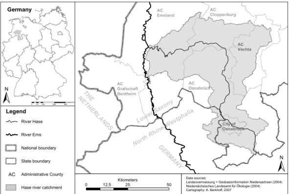
The chosen study area is the Hase river catchment in Northern Germany, which is a sub-catchment of the river Ems and covers an area of 3000 km2 (Fig. 1). 81% of the catchment area is utilised as field and grassland. The county district of Vechta,
10
most parts of which are located in the study area, has the highest chicken density of the world; 13 million chickens are kept there (Blasberg, 2006). Furthermore, parts of the study area have the highest pig density in Germany (Regional statistical office of Lower Saxony, 2005; Statistical Offices of the L ¨ander and the Federal Statistical Office, 2006). The mean value of livestock density in the region is 2.1 livestock units per
15
hectare, which is significantly higher than the German average of 0.9 livestock units per hectare. The maximum value in the study area is 3.9 livestock units per hectare.
Nitrogen emissions from intensive livestock farming have been a major point of dis-cussion in the region for many years, both in research (Gerlach, 1990; Forschungszen-trum J ¨ulich, 1991; Raderschall, 1995; Berlekamp et al., 2000; Klohn et al., 2001, 2003)
20
and among the public (Streck et al., 2001; K ¨uster, 2005; Busse, 2006; Rohwetter, 2006a, b).
The Hase river catchment was selected as a study area because its agricultural structure leads to a high pressure to act with regard to the WFD.
HESSD
4, 1133–1151, 2007 Groundwater vulnerability assessment and WFD K. Berkhoff Title Page Abstract Introduction Conclusions References Tables Figures ◭ ◮ ◭ ◮ Back CloseFull Screen / Esc
Printer-friendly Version Interactive Discussion
EGU
3 The programme of measures of the WFD
The implementation steps of the WFD which came into force in December 2000 will be briefly summarised in the following. In 2004, a preliminary inventory of the present status of surface and groundwaters was drawn up for the Article 5 report. The Arti-cle 5 report, delivered to the European Commission in 2005 by the Federal Ministry
5
for the Environment, Nature Conservation and Nuclear Safety (BMU, 2005), is a first inventory of the status of surface and groundwater bodies in each river basin district. For the Hase river catchment, the Article 5 report lead to the conclusion that 98% of the catchment area is “unclear/unlikely” to reach a good groundwater status due to dif-fuse nitrogen emissions from agriculture (NLWKN, 2005). Whole subcatchments are
10
assigned this status; there was no spatial differentiation within them. By the year 2006, the next step of WFD implementation was completed: the establishment of a moni-toring programme. Subsequently, a programme of measures will have to be released by the year 2009. The main requirements arising from the programme are (Berkhoff, 20071)
15
– a spatially explicit assessment of the current groundwater status (“reference
sce-nario”)
– the identification of priority areas for measurement planning – an assessment of the cost-effectiveness of measures .
The findings of the WFD implementation steps described above will be included in the
20
River Basin Management Plan (RBMP). The RBMP is required under Article 13 of the WFD by the year 2009 for the first time, and has to be reviewed every six years.
1
Berkhoff, K.: GIS-based groundwater vulnerability assessment in an intensively used agri-cultural area (in German, title: GIS-basierte Modellierung der Grundwasserempfindlichkeit in einer agrarischen Intensivregion), PhD thesis, Institute of Environmental Systems Research, University of Osnabr ¨uck, forthcoming, 2007.
HESSD
4, 1133–1151, 2007 Groundwater vulnerability assessment and WFD K. Berkhoff Title Page Abstract Introduction Conclusions References Tables Figures ◭ ◮ ◭ ◮ Back CloseFull Screen / Esc
Printer-friendly Version Interactive Discussion
4 The concept of vulnerability assessment
The main objective of the study presented in this paper was to develop a method which allows the identification of priority areas for the measurement planning of the WFD. Furthermore, the cost-effectiveness of groundwater protection measures should be assessed. Concerning the latter, a list of groundwater protection measures was
con-5
sidered which had been developed by local stakeholders explicitly for the study area. Stakeholders’ involvement was part of the PartizipA (“Participative modelling, Actor and Ecosystem Analysis in Regions of Intensive Agriculture”, www.partizipa.net) project of the University of Osnabr ¨uck (Germany) and the University of Klagenfurt (Austria), within which an actors’ platform was established in the study area.
10
In order to integrate the human dimension into the groundwater assessment, which in the PartizipA project was represented by the stakeholder process, the investigation was conducted as a vulnerability assessment according to the definition of the IPCC (2001). In this definition, vulnerability is a function of
– exposure
15
– sensitivity and – adaptive capacity.
The IPCC approach relates to vulnerability due to changes in climate, but it is extended in this study also to other changes of natural conditions. Metzger (2005) proceeds in a similar manner.
20
Exposure means a system’s degree of exposure to external impacts (IPCC, 2001). In the case of the study presented in this paper, exposure is the nitrogen load emanating from land use. It is computed using the STOFFBILANZ nutrient model (Gebel et al., 2005). To use this method, a reference scenario was characterised which represents the current state of agricultural practice in the study area (Berkhoff, 2006). The output
25
HESSD
4, 1133–1151, 2007 Groundwater vulnerability assessment and WFD K. Berkhoff Title Page Abstract Introduction Conclusions References Tables Figures ◭ ◮ ◭ ◮ Back CloseFull Screen / Esc
Printer-friendly Version Interactive Discussion
EGU
concentration [mg/l] in the seepage water and nitrogen load [kg/(ha*yr)] in the receiving stream.
Sensitivity is the degree to which a system responds to external impacts. It is de-scribed here by the natural groundwater pollution potential, which can be estimated by the DRASTIC index (Aller et al., 1987). The DRASTIC index is based on seven
pa-5
rameters: depth to water (5), groundwater recharge (4), aquifer media (3), soil media (2), topography (1), influence of the vadose zone media (5) and conductivity (3). The parameters are accorded different weightings (in parentheses) which were constituted in a Delphi approach (Aller et al., 1987). The weightings form the framework of the DRASTIC index; hence, they are fixed and may not be changed. The output of the
10
computation is DRASTIC indices of between 23 and 230, indicating a low (23) or a high (230) natural groundwater pollution potential.
Adaptive capacity is defined as “the degree to which adjustments in practices, pro-cesses, or structures can moderate or offset the potential for damage or take advantage of opportunities created by a given change in climate” (IPCC, 2001). In the PartizipA
15
project, the adaptive capacity of the region to reduce impacts on groundwater, partic-ularly through groundwater protection measures, was evaluated in an actors’ platform. There, stakeholders from water management, agriculture, administration, forestry and nature conservation discussed the probability of several groundwater protection mea-sures being implemented in the region. The groundwater vulnerability assessment
20
intended to support the stakeholders in planning groundwater protection measures in accordance with the WFD. The main focus of planning these measures was to reduce diffuse nitrogen emissions from agriculture. The probability of implementation for a measure depends on its costs, its acceptance by farmers, the need to control its appli-cation, and the synergy effects of the measure (Berkhoff et al., 2006). The probability
25
of implementation was examined by the stakeholders for 14 groundwater protection measures.
HESSD
4, 1133–1151, 2007 Groundwater vulnerability assessment and WFD K. Berkhoff Title Page Abstract Introduction Conclusions References Tables Figures ◭ ◮ ◭ ◮ Back CloseFull Screen / Esc
Printer-friendly Version Interactive Discussion
5 The groundwater vulnerability evaluation scheme
Both the STOFFBILANZ model and the DRASTIC index were calculated on a 500×500 metre grid. A spatially resolved analysis of groundwater vulnerability is a prerequisite for the measurement planning of the WFD. The vulnerability assessment approach chosen for the study enjoys the advantage that both exposure and sensitivity can be
5
operationalised in a spatially resolved manner by the two models mentioned above. Each grid cell of the catchment is assigned a certain value of exposure (nitrogen load) and sensitivity (DRASTIC index). Unlike exposure and sensitivity, adaptive capacity cannot be identified on the basis of a grid. The adaptive capacity was evaluated in a semi-quantitative way in an assessment table (Berkhoff et al., 2006). The result of
10
the stakeholder process was published in a final document (ibid.), which contains a description of the stakeholders’ judgements of the groundwater protection measures. From the document it can be taken that the adaptive capacity of the region is very low; as a result, it was no longer considered in the further process of the groundwater vulnerability assessment. In regions with a high adaptive capacity, it can be integrated
15
into the evaluation scheme described in Table 1 by evaluating the nitrogen loads of the “adaptation scenario” instead of those of the reference scenario.
The scheme for the evaluation of groundwater vulnerability is based on the Northern Saxon approach of groundwater assessment used in the WFD (International River Basin District Ems, 2005). The advanced groundwater vulnerability evaluation scheme
20
is shown in Table 1 and consists of four columns
– nitrogen load in seepage water [kg N/(ha*yr)] – total runoff [mm/yr]
– DRASTIC-Index
– nitrogen concentration in seepage water [mg N/l].
HESSD
4, 1133–1151, 2007 Groundwater vulnerability assessment and WFD K. Berkhoff Title Page Abstract Introduction Conclusions References Tables Figures ◭ ◮ ◭ ◮ Back CloseFull Screen / Esc
Printer-friendly Version Interactive Discussion
EGU
Nitrogen load and nitrogen concentration are both computed using the STOFFBILANZ model for the reference scenario. Furthermore, total runoff is calculated in the water balance module of the STOFFBILANZ model.
In contrast with the original approach used in Northern Saxony, the groundwater vul-nerability assessment in this study was conducted spatially resolved on a 500×500
me-5
tre grid. The evaluation scheme distinguishes between two classes: “high vulnerability/ pressure to act” and “low vulnerability/pressure to act”. Grid cells that are not assigned to one of these classes are grouped in the class “medium vulnerability/pressure to act”. For the nitrogen load in seepage water, a threshold value of 90 kg/(ha*yr) was defined for the high vulnerability class, which reflects the high level of pollution in the study area.
10
In order to be able to identify priority areas in a region, the threshold value has to be ad-justed to the situation prevalent in the study area. The threshold value of 90 kg/(ha*yr) is also included in the German fertilizer regulation (D ¨uV, D ¨ungeverordnung 2006). A threshold of 10 mg nitrogen/(ha*yr) has only been defined for grid cells with a very low total runoff of below 150 mm/yr. For the low vulnerability class, threshold values of 10
15
to 40 kg nitrogen/(ha*yr), depending on the total runoff, were taken from the Northern Saxon approach.
Referring to Aller et al. (1987), three groups were established for the DRASTIC index:
– low groundwater pollution potential (<120)
– medium groundwater pollution potential (120–159)
20
– high groundwater pollution potential (>159).
Grid cells can only be assigned to the low vulnerability group if their DRASTIC index is below 120.
There are two threshold values for the nitrogen concentration. 33 mg nitrogen/l corre-sponds to nearly 150 mg nitrate/l; as in the case of nitrogen loads, it was necessary to
25
choose this high threshold value to identify priority areas. 9 mg nitrogen/l corresponds to 40 mg nitrate/l and was also taken from the evaluation scheme used in Northern Saxony.
HESSD
4, 1133–1151, 2007 Groundwater vulnerability assessment and WFD K. Berkhoff Title Page Abstract Introduction Conclusions References Tables Figures ◭ ◮ ◭ ◮ Back CloseFull Screen / Esc
Printer-friendly Version Interactive Discussion
6 Results
21% of the catchment was classified as highly vulnerable. The areas of high vulner-ability are concentrated in the north-eastern part of the catchment area, due to high nitrogen loads and high levels of nitrogen concentration in the seepage water there. Figure 2 shows the result of applying the evaluation scheme described in chapter 5 to
5
the study area.
In addition to the high pressure coming from exposure, the sensitivity of several com-munities in the north-eastern part of the study area is also rather high. In this region, the DRASTIC index reaches up to 158. Grid cells in the north which are assigned a low vulnerability are, without exception, those of the land use classes grassland, forest
10
or settlement. Grid cells of the land use class field in this part of the catchment are mainly assigned to the high vulnerability class.
In the north-western part of the study area, clusters of highly vulnerable grid cells can also be found. The high vulnerability in this part of the region, however, is caused by high DRASTIC indices of around 170 and only slightly increased levels of nitrogen
15
load just above the threshold value of 90 kg/(ha*yr).
In general, the northern part of the study area, which is characterised by unconsoli-dated sediments, is more vulnerable than the bedrock aquifer in the south of the study area. This is mainly due to the more intensive structure of agriculture in the northern part of the catchment. Most of the grid cells in the low vulnerability class are located
20
in the southern bedrock aquifer area. These are generally characterised by very low DRASTIC indices of below 100 and low levels of nitrogen load and concentration. Only single grid cells in the south near the river Hase are assigned to the high vulnerability class because of high DRASTIC indices existing at some sites there. In the bedrock aquifer area it has to be recognised that, due to the heterogeneous structure of the
25
aquifer media and the potential occurrence of fractures, single hot spots of vulnerabil-ity are possible which are not grasped by the evaluation scheme.
HESSD
4, 1133–1151, 2007 Groundwater vulnerability assessment and WFD K. Berkhoff Title Page Abstract Introduction Conclusions References Tables Figures ◭ ◮ ◭ ◮ Back CloseFull Screen / Esc
Printer-friendly Version Interactive Discussion
EGU
vulnerability class.
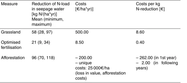
For the WFD measurement planning, it is necessary to calculate the efficiency of measures in addition to the evaluation of groundwater vulnerability. This can also be carried out by the STOFFBILANZ model. As an example, Table 2 shows the results of STOFFBILANZ for three groundwater protection measures. The costs included in
Ta-5
ble 2 for each measure are derived from the stakeholders of the actors’ platform. The values are judged from the stakeholders’ experience in the conduction of measures in the region. It can be taken from Table 2 that the support of measurement planning by the STOFFBILANZ model delivers valuable information, like the nitrogen reduction potential of the measures. The transformation of fields to grassland causes an average
10
nitrogen reduction of 58 kg/(ha*yr). Optimised fertilisation results only in a 21 kg nitro-gen reduction/(ha*yr), whereas the reduction potential of the afforestation measure is clearly higher (96 kg/(ha*yr)). But if the costs, as evaluated by the stakeholders, are also integrated into the assessment, a different picture emerges. Optimised fertilisation is the least expensive measure, costing only 0.40 €/kg nitrogen reduction. In the
con-15
trary, afforestation demands much higher funding, particularly due to high initialising costs for the implementation of the measure. These costs are compensated by low maintenance costs of only 2.00 €/(ha*yr). The transformation of fields to grassland has a moderate cost efficiency of 8.60 €/kg nitrogen reduction.
7 Conclusions
20
As a result of the vulnerability assessment, it was possible to identify priority areas for the measurement planning in the Hase river catchment. The implementation of measures should start in the highly vulnerable areas, as shown in the vulnerability map. Although the vulnerability map serves as a basis for discussion, local expert knowledge should also be integrated into measurement planning. Moderately vulnerable areas
25
should be dealt with as a secondary priority, whereas in areas with low vulnerability there is little pressure to act. The cost-efficiency of measures can be computed using
HESSD
4, 1133–1151, 2007 Groundwater vulnerability assessment and WFD K. Berkhoff Title Page Abstract Introduction Conclusions References Tables Figures ◭ ◮ ◭ ◮ Back CloseFull Screen / Esc
Printer-friendly Version Interactive Discussion the STOFFBILANZ model if cost estimations for the measures are available. Thus, it is
possible to rank the groundwater protection measures which are suitable for the region of concern according to their expected cost-efficiency.
The integration of the model-based vulnerability assessment in the PartizipA actors’ platform showed that the context of model application plays a major role in its
success-5
ful implementation in the stakeholder process. This is also confirmed by other authors (McIntosh et al., 2004; van Daalen et al., 2006; Kastens and Newig, 2007). All issues describing the context of the case study can be categorised under the following seven topics:
1. External factors
10
2. Resources at disposal 3. Modelling purpose 4. Intended utilisation level 5. Key stakeholder
6. Motivation of the stakeholder group to use the model results
15
7. Method of visualisation.
All categories mentioned above should be considered for model application. First, ex-ternal factors influencing the modelling process have to be discovered. That can be the requirements of the WFD, as in the PartizipA case study, but it can also be the scale on which information is supposed to be given. In the second step, the available resources
20
have to be fixed. They include time, manpower and financial resources as well as data availability. The modelling purposes and the intended utilisation level of the model re-sults should be clearly described. An own category is proposed for the existence of a partner with practical experience as a key stakeholder, representing the link between project organisers (e.g. a research institute) and local stakeholders (e.g. farmers). The
HESSD
4, 1133–1151, 2007 Groundwater vulnerability assessment and WFD K. Berkhoff Title Page Abstract Introduction Conclusions References Tables Figures ◭ ◮ ◭ ◮ Back CloseFull Screen / Esc
Printer-friendly Version Interactive Discussion
EGU
motivation of the stakeholder group to use the model results depends on several is-sues like the power structure in the stakeholder group, the “tradition” of stakeholders discussing the problem at stake the concern of the stakeholders towards the problem and their ability/experience in understanding the model. The seventh category refers to the method of visualising the model results, which is important to communicate about
5
the model results. Following that, the case study provided evidence for the statement that it is useful to distinct between different kinds of models according to their main application purpose:
1. Simple, easy-to-understand models designed in collaboration with the stakehold-ers as a decision support tool explicitly for the region of concern, being operable by the
10
stakeholders directly in the participatory process.
2. Sophisticated, scientifically sound expert models, run prior to the participatory process, presenting the final results including statistical analyses and validation proce-dures later on in the participatory process.
Both types of models are designed to build trust in the model results, since model
15
application in stakeholder processes is not a goal in itself, but serves as a means for providing expert information to a decision-making process.
In the paper, a groundwater vulnerability assessment approach was applied to the Hase river catchment in Germany. It was shown that the approach is suitable for the implementation of the WFD’s programme of measures. Since it combines the
assess-20
ment of the groundwater status and the human dimension of the adaptive capacity of the region under study, it fully meets the requirements of the WFD.
Acknowledgements. This work was funded as part of the PartizipA (Participative modelling,
Actor and Ecosystem Analysis in Regions of Intensive Agriculture, 10/2003–03/2007) project by the German Ministry of Education and Research under grant no. 07 VPS 10.
25
HESSD
4, 1133–1151, 2007 Groundwater vulnerability assessment and WFD K. Berkhoff Title Page Abstract Introduction Conclusions References Tables Figures ◭ ◮ ◭ ◮ Back CloseFull Screen / Esc
Printer-friendly Version Interactive Discussion
References
Aller, L. T., Bennett, T., Lehr, J. H., Petty, R. J., and Hackett, G.: DRASTIC – A standard-ized system for evaluating groundwater pollution potential using hydrogeologic settings, U.S. Environmental Protection Agency/600/2-87/035, Washington, 1987.
Berding, V., Berlekamp, J., and Matthies, M.: Vergleich von Maßnahmen zur Verbesserung der 5
Wasserqualit ¨at privater Hausbrunnen im Landkreis Osnabr ¨uck, Wasser und Boden, 51, 4, 41–45, 1999.
Berkhoff, K.: Application of a GIS-based groundwater vulnerability assessment in a partici-patory process, in: Managing Environmental Knowledge, edited by: Tochtermann, K. and Scharl, A., Shaker, Aachen, 389–392, 2006.
10
Berkhoff, K., Kaldrack, K., Kastens, B., Newig, J., Pahl-Wostl, C., and Schlussmeier, B.: EG-Wasserrahmenrichtlinie und zukunftsf ¨ahige Landwirtschaft im Landkreis Osnabr ¨uck.
Schlussdokument zum PartizipA-Akteursforum September 2004 – M ¨arz 2006, http://www.
partizipa.uni-osnabrueck.de/docs/Schlussdokument%20final web.pdf, 2006.
Berlekamp, J., Fuest, S., Gl ¨aßer, W., Matthies, M., Schreck, P., and Th ¨urkow, D.: Trinkwasser 15
aus privaten Hausbrunnen – Situation und Qualit ¨atssicherung, Erich Schmidt Verlag, Berlin, 2000.
Blasberg, A.: Hysterie in Chicken Country, ZEIT, 9, 60, 2006.
BMU (Federal Ministry for the Environment Nature Conservation and Nuclear Safety): Die Wasserrahmenrichtlinie - Ergebnisse der Bestandsaufnahme 2004 in Deutsch-20
land, http://www.wasserblick.net/servlet/is/32383/WRRL-BroschuereJuli2005 final.pdf?
command=downloadContent&filename=WRRL-BroschuereJuli2005 final.pdf, 2005.
Busse, T.: Gerupfte Preise - Die Vogelgrippe breitet sich aus, und H ¨ahnchenm ¨aster k ¨ampfen um ihre Existenz, ZEIT, 10, 25, 2006.
D ¨uV (D ¨ungeverordnung): Verordnung ¨uber die Anwendung von D ¨ungemitteln, Bodenhilfsstof-25
fen, Kultursubstraten und Pflanzenhilfsmitteln nach den Grunds ¨atzen der guten fachlichen Praxis beim D ¨ungen vom 10. Januar 2006, BGBl. I Nr. 2, 33, 2006.
Forschungszentrum J ¨ulich: Intensivlandwirtschaft und Nitratbelastung, J ¨ulich, 1991.
Gebel, M., Grunewald, K., and Halbfaß, S.: STOFFBILANZ – program manual (in German), state november 2005, Technische Universit ¨at Dresden, 1–33, 2005.
30
Gerlach, J.: Gesellschaftswissenschaftliche Betrachtung der Nitratbelastung im Grundwasser von drei Landkreisen mit intensiver Tierproduktion: Vechta, Osnabr ¨uck, Steinfurt,
Os-HESSD
4, 1133–1151, 2007 Groundwater vulnerability assessment and WFD K. Berkhoff Title Page Abstract Introduction Conclusions References Tables Figures ◭ ◮ ◭ ◮ Back CloseFull Screen / Esc
Printer-friendly Version Interactive Discussion
EGU nabr ¨uck, 1990.
G ¨otze, R.: Erfurter Gespr ¨ache zur Wasserrahmenrichtlinie, Deutsches Verwaltungsblatt, 13, 825–828, 2005.
IPCC (Intergovernmental Panel on Climate Change): Climate Change 2001: Impacts, adap-tation, and vulnerability, contribution of working group II to the Third Assessment Report of 5
the Intergovernmental Panel on Climate Change, Cambridge University Press, Cambridge, 2001.
Kastens, B. and Newig, J.: Will great expectations in Brussels be dashed in Lower Saxony? The effectiveness of the Water Framework Directive regarding the key issue of agricultural nitrate pollution, European Environment, in press, 2007.
10
Klohn, W. and Windhorst, H.-W.: Das agrarische Intensivgebiet S ¨udoldenburg – Entwicklung, Strukturen, Probleme, Perspektiven, Vechtaer Druckerei und Verlag, Vechta, 2001.
Klohn, W. and Windhorst, H.-W.: Die sektoralen und regionalen Strukturen der Rinder- und Schweinehaltung in Deutschland, Vechtaer Druckerei und Verlag,Vechta, 2003.
K ¨uster, H.: Die Serengeti und der Landkreis Vechta d ¨urfen nicht sterben, Frankfurter Allge-15
meine Zeitung, 2005.
McIntosh, B. S., Seaton, R. A. F., and Jeffrey, P.: Tools to think with? Towards understanding the use of computer-based support tools in policy relevant research, in: Pahl-Wostl, C., Schmidt, S., Rizzoli, A. E., and Jakeman A. J.: Complexity and Integrated Resources Management, Transactions of the 2nd Biennial Meeting of the International Environmental Modelling and 20
Software Society, iEMSs, Manno, Switzerland, 2004.
Metzger, M. J.: European vulnerability to global change, a spatially explicit and quantitative assessment, Phd thesis, Wageningen University, 2005.
Nies, V., Rocha, B., and Skupien, A.: Auswirkungen der Wasserrahmenrichtlinie und EU-Grundwasserschutzrichtlinie, Agrar- und Umweltrecht, 4, 120–126, 2006.
25
NLWKN (Northern Saxon authority for water management and the protection of coasts and nature): B-Bericht 2005, Gebiet: Mittlere Ems,http://www.wasserblick.net/servlet/is/36468/, 2005.
Raderschall, R.: Diffuse Stoffeintr ¨age aus landwirtschaftlich intensiv genutzten Einzugsgebi-eten, Zentralblatt f ¨ur Geologie und Pal ¨aontologie (Teil I), 10, 957–968, 1995.
30
Regional statistical office of Lower Saxony: Agricultural structure survey 2003 (data table), retrieved 01.08.2005.
HESSD
4, 1133–1151, 2007 Groundwater vulnerability assessment and WFD K. Berkhoff Title Page Abstract Introduction Conclusions References Tables Figures ◭ ◮ ◭ ◮ Back CloseFull Screen / Esc
Printer-friendly Version Interactive Discussion
so weit getrieben wie beim H ¨ahnchen, ZEIT, 27, 17, 2006a.
Rohwetter, M.: Hand in Hand – Mehr Kontrollen, lautet die Forderung nach jedem
Gammelfleisch-Skandal, ZEIT, 49, 29, 2006b.
Statistical Offices of the L ¨ander and the Federal Statistical Office: Stock of pigs on May 3, 2006.
http://www.statistik-portal.de/Statistik-Portal/de jb11 jahrtab22.asp, 2006. 5
Streck, M., Handl ¨ogten, G., Bauer, W., and Schl ¨ager, G.: Landwirtschaft – im Cloppenburger Land wird die Umwelt vergiftet, Stern, 16, 72-88, 2001.
van Daalen, E. and Bots, P.: Participatory model construction and model use in natural resource management, Workshop “Formalised and Non-Formalised Methods in Resource Manage-ment – Knowledge and Learning in Participatory Processes”, Osnabr ¨uck, 21–22 September, 10
2006.
WFD (Water Framework Directive) Directive 2000/60/EC of the European parliament and of the council of 23 October 2000 establishing a framework for Community action in the field of water policy, Official Journal of the European Communities L 327/1of 22 December 2000, 2000/60/EC, 1–72.
HESSD
4, 1133–1151, 2007 Groundwater vulnerability assessment and WFD K. Berkhoff Title Page Abstract Introduction Conclusions References Tables Figures ◭ ◮ ◭ ◮ Back CloseFull Screen / Esc
Printer-friendly Version Interactive Discussion
EGU Table 1. Evaluation scheme for groundwater vulnerability assessment.
Vulnerability/ Pressure to act N-load in seepage water [kg N/(ha*yr)] Total runoff [mm/yr] DRASTIC index N-concentration in seepage water [mg N/l] high >90 >159 >159 >33 >90 >33 >10 <150 >119 <10 <120 <120 <9 <10 <9 low (DRASTIC index <120) <20 <250 <120 <30 >250−350 <120 <40 >350 <120
HESSD
4, 1133–1151, 2007 Groundwater vulnerability assessment and WFD K. Berkhoff Title Page Abstract Introduction Conclusions References Tables Figures ◭ ◮ ◭ ◮ Back CloseFull Screen / Esc
Printer-friendly Version Interactive Discussion
Table 2. Effectiveness of three selected groundwater protection measures as computed by the STOFFBILANZ model.
Measure Reduction of N-load
in seepage water [kg N/(ha*yr)] Mean (minimum, maximum) Costs [€/ha*yr)] Costs per kg N-reduction [€] Grassland 58 (28, 97) 500.00 8.60 Optimised fertilisation 21 (9, 34) 8.50 0.40 Afforestation 96 (70, 118) – 200.00 – unique costs: 25 000€/ha
(loss in value, afforestation costs)
– 262.00 (in 1st year) – 2.00 (in following years)
HESSD
4, 1133–1151, 2007 Groundwater vulnerability assessment and WFD K. Berkhoff Title Page Abstract Introduction Conclusions References Tables Figures ◭ ◮ ◭ ◮ Back CloseFull Screen / Esc
Printer-friendly Version Interactive Discussion EGU AC Osnabrück AC Vechta AC Cloppenburg AC Emsland AC Grafschaft Bentheim Lowe r Sax ony North Rhin e-Wes tpha lia City of Osnabrück 0 12,5 25 50 Kilometers G ER M AN Y TH E N ETH ER LA N DS Legend River Hase River Ems National boundary State boundary Administrative County AC
Hase river catchment
Data sources:
Landesvermessung + Geobasisinformation Niedersachsen (2004) Niedersächsisches Landesamt für Ökologie (2004) Cartography: K. Berkhoff, 2007
Germany
HESSD
4, 1133–1151, 2007 Groundwater vulnerability assessment and WFD K. Berkhoff Title Page Abstract Introduction Conclusions References Tables Figures ◭ ◮ ◭ ◮ Back CloseFull Screen / Esc
Printer-friendly Version Interactive Discussion 0 12,5 25 50 Kilometers Vulnerability High Low Medium River Hase
Fig. 2. Vulnerability map of the Hase river catchment (vulnerability is corresponding to the priority for the measurement planning).