HAL Id: hal-01699811
https://hal.archives-ouvertes.fr/hal-01699811
Submitted on 2 Feb 2018
HAL is a multi-disciplinary open access
archive for the deposit and dissemination of
sci-entific research documents, whether they are
pub-lished or not. The documents may come from
teaching and research institutions in France or
L’archive ouverte pluridisciplinaire HAL, est
destinée au dépôt et à la diffusion de documents
scientifiques de niveau recherche, publiés ou non,
émanant des établissements d’enseignement et de
recherche français ou étrangers, des laboratoires
Cape Town
Myriam Houssay-Holzschuch, Olivier Ninot, Emma Thébault
To cite this version:
Myriam Houssay-Holzschuch, Olivier Ninot, Emma Thébault. Watch this space! A Visual Essay
on vacant land in Cape Town. Cybergeo : Revue européenne de géographie / European journal of
geography, UMR 8504 Géographie-cités, 2018, pp.1-40. �10.4000/cybergeo.28974�. �hal-01699811�
Watch this space! A Visual Essay on vacant land in
Cape Town
C'est ici que ça se passe ! Essai visuel sur les espaces vacants au Cap en Afrique
du Sud
Myriam Houssay-Holzschuch, Olivier Ninot and Emma Thébault
Electronic version
URL: http://journals.openedition.org/cybergeo/28974 ISSN: 1278-3366
Publisher
UMR 8504 Géographie-cités
Brought to you by Bibliothèque Diderot de Lyon et ENS
Electronic reference
Myriam Houssay-Holzschuch, Olivier Ninot and Emma Thébault, « Watch this space! A Visual Essay on vacant land in Cape Town », Cybergeo : European Journal of Geography [Online], Space,
Society,Territory, document 843, Online since 02 February 2018, connection on 02 February 2018. URL : http://journals.openedition.org/cybergeo/28974
This text was automatically generated on 2 February 2018. © CNRS-UMR Géographie-cités 8504
Watch this space! A Visual Essay on
vacant land in Cape Town
C'est ici que ça se passe ! Essai visuel sur les espaces vacants au Cap en Afrique
du Sud
Myriam Houssay-Holzschuch, Olivier Ninot and Emma Thébault
The authors wish to thank two Agence Nationale de la Recherche projects (project PERISUD No. Suds-07-046 headed by Jean-Louis Chaléard; project MEDIAGEO No. ANR-09-BLAN-0351-01 headed by Isabelle Lefort), the Institut Universitaire de France and the DALVAA project (funded by Ville de Paris – Émergence, and headed by Marianne Morange and Amandine Spire) for funding. Jean-François Perrat-Mabillon, and Florence Padovani kindly agreed to allow us to use some of their photos. Martine Berger accompanied us during our exploration of and obsession with trous of various kinds. A first version of this text was presented at the “Ecologies of Protest” Workshop in Durham – thanks to Lynn Staeheli, who organized it, and to all the participants for feedback and discussions. For the final text, many thanks to the reviewers for their accurate and constructive comments, and to Ilse Evertse for her proof-reading skills that vastly improved our writing – qui bene amat bene castigat!
Figure 1: Monwabisi Beach, Cape Town
Source: Authors, March 2011
1 Monwabisi Beach, Cape Town (Figure 1). A former African-only beach under apartheid, Monwabisi Beach is now many things: a place of leisure for nearby, overcrowded Khayelitsha, where a growing African middle-class lives beside informal settlements; a place of biodiversity where the indigenous flora, sand fynbos, and the magnificent coastline are protected. It is also a place for municipal projects — a blank space reflecting the diverging visions of the future city in a somewhat confusing way.
2 These variegated possibilities demonstrate the diversity of possible vacant land use in
Cape Town. This land use is crucial, because the city faces huge social, political, and environmental issues. Vacant pieces of land of various sizes around and in the city constitute a hotly disputed, key resource that could help address urban issues. It might be especially crucial in Cape Town’s contemporary context of massive inequalities inherited from the apartheid era, neoliberalization, increasing social polarization, and political protests - all occurring in a city characterized as already segregated to the extreme, fragmented, and splintered. This empirical case study is one of the present paper’s objectives.
3 But the question of vacant land is certainly not unique to Cape Town, as recent literature has shown in other, urban, empirical settings (see below). This leads us to our second objective, an exploration of a more theoretical nature, namely taking vacant land seriously as an object of research and using it to analyze urban fragmentation. By its very nature, vacant land gives rise to the question of what lies between the urban splinters. This requires conceptualizing vacant land beyond its variegated current definitions, as well as combining methods able to document what happens in, to and about vacant land on various scales, including spur-of-the-moment uses. We believe that vacant land is,
simultaneously, of critical ecological and political importance, as well as a strong heuristic and theoretical tool.
Taking vacant land seriously: Concepts and methods
Vacant land for understanding urban fragmentation
Vacant spaces are worth contemplating as both places and notion
4 Vacant pieces of land have, in many guises, long been an important city element around the world, whether as not-as-yet built-up pieces of land (especially edgelands, see Qviström and Saltzman 2008), as plots lying fallow after previous use, or as space kept open for temporary (e.g. fairs and markets), or more permanent — mostly collective — uses (e.g. the no-man’s-land around city walls). Sometimes ignored, or even feared as hiding places for criminals, vacant land gradually became a tool for planners, who mostly saw them as empty plots to be filled with whatever they wanted to develop in order to make the city more competitive, or more inclusive: industrial areas, malls, housing, or infrastructures. Vacant land was thus a sought-after and often limited resource to be used for other urban purposes. However, the recent focus on shrinking cities has started to shift this approach to vacant land (Németh and Langhorst 2013; Silverman, Yin, and Patterson 2013; Pearsall and Lucas 2014; Johnson, Hollander, and Hallulli 2014). In these cities, vacant land has become increasingly available as factories close, homes are razed in the subprime crisis aftermath, and infrastructures decay. The question is: to be used to what end? Consequently, a great deal of the existing literature on vacant land is grounded in the shrinking cities of the West.
5 Here, the discussion on vacant land, and what to do with it, is beginning to encounter the
discussion on the need for more sustainable cities. Using vacant land smartly can indeed help make cities more compact, thus reducing urban sprawl and its associated environmental ills, for example, the loss of agricultural land and natural habitats, increased car use, pollution, etc. But the shift has been more profound: vacant land is beginning to be taken seriously as a resource for more sustainable cities, because it is vacant. From an economical point of view, allowing a plot to lie fallow for a while has been shown to be an efficient strategy to later recycle it into the property market at a higher value (Nussbaum 2015). Alternatively, vacancy as an intrinsically valuable condition — if less directly marketable — has started emerging. For instance, Qviström and Saltzman (2006) have emphasized the biodiversity that vacant urban land hosts – it is therefore intrinsically valuable from an environmental point of view. Social sustainability has also been linked to vacant land: analysts and practitioners increasingly insist on the need for more flexible and open urban space usage, thus allowing for quick and spontaneous answers to social urban needs, Do-It-Yourself urbanism (Iveson 2013), and innovative, even alternative, uses of space. Because it has no previous and fixed function, vacant land is especially suitable for such practices. In short, vacant land is now
recognized as an environmental and social asset beside its economic value. Again, most of these insights are from studies in Europe and Northern America.
6 The empirical value of vacant land has led researchers to examine its conceptualization. The literature provides a variety of definitions that opens up a stimulating, though not completely structured, conceptual field. Vacant land covers:
1. Open spaces, urban open spaces, vacant spaces, green spaces, or spaces left over after planning (SLOAP), as mentioned in Cape Town’s planning documents (Thébault 2012); 2. Interstices, whose Latin etymology is ambivalent, because it stems simultaneously from
interstitio, the passive and an indeterminate space between two elements, and inter stare,
standing between, which is an active positioning (Tonnelat 2003, 86); 3. “Wastelands” (Qviström 2008);
4. “Ruderal sites” and places for weeds – “a crucial metaphor” of “any plant in the wrong place, and therefore a problem or at the very least a plant of no value” - or a “landscape out of order” (Qviström 2007, 271-2);
5. “Ephemeral landscape” or “landscape in limbo” (Qviström and Saltzman 2006, 38);
6. No-man’s land, as in the innovative and stimulating work of Leshem and Pinkerton (2016); and
7. Ruins with grey and brownfields complicating the picture (DeSilvey and Edensor 2013)
7 Several crucial elements can be deduced from this array of definitions: vacant land is a
space that is (1) unbuilt or ruined; (2) has no clearly allocated use or function; (3) is caught in a specific and suspended temporality. To clarify the last point: vacant land has been and/or will be something – but is not quite there as yet. French geographer Bachimon (2013) has likened it to Sleeping Beauty’s castle: once there was a castle here; there will, at the (happy) end of the tale, be a castle again. In the meantime, it is covered with weeds and thorn-bush, and has slipped from view and memory.
8 These three elements, to be used separately, or combined, constitute a working definition of vacant land that is intentionally rather extensive, as we wish to make a case for taking vacant land seriously, also on the conceptual level. This might require a definition as open as vacant land, but which we can summarize as being space out of place that disrupts the urban fabric and its logic.
9 Redefining vacant land this ways is especially useful as it allows us to explicitly link this notion on a theoretical level to the rich debates on the question of urban fragmentation that have animated geography and urban studies since the 1990s. However, the literature hasn’t quite made this link as yet (nevertheless see Iossifova 2013). What lies between the fragments has been largely overlooked.
10 Indeed, a brief look at the rather well known fragmentation idea and theories, from both the Anglophone — mostly Angelina — and the Francophone traditions shows this gap. The Los Angeles School of urban studies showed empirically and theoretically how Los Angeles and the postmodern cities it modeled were becoming more diverse and even socially, economically, politically, and morphologically polarized (Soja 2000). In this context, Dear and Flusty (1998) famously argued for the city as a checkerboard under Keno capitalism: self-contained islands of poverty, privilege, housing, or consumption juxtaposed with only an undulating line separating them. On a different timeline, French geographers, analyzing the cities of the Global South, came up with the idea of their spatial and social fragmentation, which differ from the segregation inherited from the colonial city in that the city no longer constitutes a functional whole (Navez-Bouchanine
2002; Jaglin 2001). In a third take, Graham and Marvin (2001) analyzed urban services’ differentiation in space, content, governance, and quality, suggesting the idea of splintering urbanism.
11 These three corpuses are all subsumed under the fragmentation (or splintering) phenomena belonging to different realms (the political, the social…), which is one of the strengths of the notion. In addition, they all add a physical and morphological dimension to the mix – often somewhat uneasily (Dorier-Apprill 2001), but one that tries to account for the multiplication of physical breaks in the urban fabric, whether they are walls, gates, or empty pieces of land.
12 However, in these cities conceptualized as heterogeneous fragments, or splinters, the status of the separations between gated communities, corporate citadels, street warfare neighborhoods, etc. is often unquestioned (Dorier-Apprill and Gervais-Lambony 2007). Are these separations as basic and similar as led came in a glass pane? What does lie in the spaces between the fragments? A possible answer is what we offer with the Cape Town case – a fast-growing city whose social and physical fragmentation was thoroughly shown before and after apartheid (Dewar et al. 1990).
Experiencing vacant land, making it visible
13 Taking vacant space seriously, especially as vacant, gives rise to specific methodological problems, as it is often, in Salman Rushdie’s words, “visible, but unseen.” In other, more geographic, words, vacant land has a diverse, even paradoxical, regime of visibility, ranging from personal perceptions to marketed hypervisibility to invisibilization. We used three techniques, detailed below to make it visible for enquiry: a reflexive approach to our sensorial perceptions in the field, systematic mapping, and photo-documentation.
14 Our enquiry into vacant land in Cape Town started with exercising reflexivity in terms of our perceptions, both individually and collectively. During our joint fieldwork for other projects, we were subject to the strong visual experience of frequent “holes” in the urban fabric: dense neighborhoods would suddenly give way to empty open spaces, only to return after several hundred meters. Clear buffer zones would surround residential and industrial neighborhoods. Elements of the natural environment (the majestic Table Mountain, the oceans, but also hills, dunes, lagunas, marshes, etc.) would disrupt the city sprawl. This shared visual experience, an approche sensible, of the landscape we crisscrossed, led us to a more formal enquiry into the importance of non-built, or vacant, land in Cape Town.
15 Municipal planning documents helped us comprehensively map the location, extension, and sometimes vacant land’s allocated function (see Figure 2). At that stage, we deliberately used a very wide definition of vacant land as unbuilt areas, which was in line with our initial experience, and mapped it as such by conflating heterogeneous categories of non-built spaces: agricultural areas, conservation areas, metropolitan open spaces, and vacant and undeveloped land (Myers 1975; Maruani and Amit-Cohen 2007; Brown-Luthango, Makanga, and Smit 2013). To our delight, the city’s data and planning framework were structured in such a way that they did not only allow our categorization, but legitimized its wideness. The MOSS (Metropolitan Open Space System)1, an integrated
municipal framework that oversees all open spaces (i.e. non-built spaces), considers the categories a single system to be managed as such. Mapping them reveals a city in which
made invisible by Table Mountain’s looming presence, most of these spaces are unremarkable, forming, with brownfields, a marquetry of discrete urban elements (Figure 3).
Figure 2: Typology of vacant land in Cape Town, using municipal categories.
Source: Authors, using City of Cape Town 2001 data, reproduced from Ninot & Tallet 2014.
16 However, while planning sources allowed us to assess the size and location of vacant land, they are insufficient to document the way they are actually used. During our fieldtrips between 2009 and 2015, we therefore shifted our data-collection methods to observation and photo-documentation (Rose 2012). We believe, with Gillian Rose, that photo-essays such as ours are: “ways of understanding visual aspects of social relations and identities in contemporary urban spaces (…). [I]mages such as photographs are seen as especially valuable in urban research because they can convey something of the feel of urban places, space and landscapes, specifically of course of those qualities that are in some way visible: they can suggest the layout, colour, texture, form, volume, size and patterns of the built environment, for example, and can picture people too. Photographs can thus capture something of the sensory richness and human inhabitation of urban environments.” (Rose 2012, 298)
We combined spur-of-the-moment photos documenting a specific event with systematic photos of vacant land, as our cartographic work indicates during our city transects. The photos we insert here play different roles as the paper progresses.
17 First, they are aimed at sharing our visual impressions, the “sensual immanence” (Edensor 2005, 15), the “sense of the subjective experiencing of a social situation” (Rose 2012, 319; see also Tormey 2013) that inspired our project: the City of Cape Town is strewn with spaces that, visually, seem vacant.
18 Second, these photos work as visual material for a three-pronged analysis: (a) Vacant land
in Cape Town is sometimes made hypervisible, most notably in official discourses on the environment. In this context, poster images function as marketing tools to be analyzed as such. (b) Our photo-documentation work renders the plots of vacant land visible that urban marketing discourses invisibilize, as well as what happens on existing vacant land. Such photographic records are especially valuable as vacant land is “in a fluid state of material becoming” (Edensor 2005, 16). Our images therefore take on a more demonstrative role. (c) Lastly, neither the local authorities, nor our documentation work makes some vacant spaces visible, but the local civil society actors do. Our photographs, which report their actions, are thus more of an illustrative nature as they showcase intensely contested spaces.
The fragmented urban nature of Cape Town
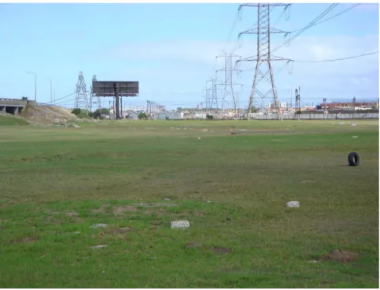
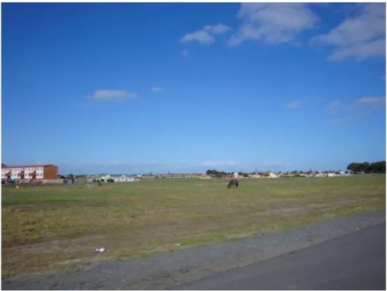
Figure 3: Duinefontein Road, Heideveld.
Figure 4: Between Langa and Epping Industrial.
Source: authors, March 2011.
Figure 5: Govan Mbeki Road (formerly Lansdowne Road), Gugulethu.
Figure 6: Ottery Road, Ottery.
Source: authors, April 2012.
Figure 7: Khayelitsha, seen from Lookout Hill.
Figure 8: Main Road, between Diep River and Bergvliet.
Source: authors, April 2012.
Figure 9: Crossroads Duinefontein & Klipfontein Road, Heideveld.
Source: Jean-François Perrat-Mabillon, March 2013, used with permission.
19 With this first series of photos, we hope to share our perceptions of Cape Town as a city with ubiquitous empty spaces with the reader. These spaces lie between neighborhoods, within residential areas, surround public buildings, and extend transport infrastructures. These recurrent empty spots join bigger ones – the Mountain and the agricultural edgelands – as well as parks and golf courses. Together, they give an impression of spatial fragmentation when one crisscrosses the city.
Figure 10: Cape Town’s non-built spaces.
A- Built areas appear in grey, unbuilt in white.
Figure 11: Pinelands, Athlone, Langa, the Cape Town marquetry of residential neighborhoods and “holes”
Source: Google Earth, 2014.
20 A map of Cape Town’s non-built spaces (Figure 10) confirms their sheer size and ubiquity when they are highlighted beyond their problematic visibility — a good reason to explore vacant land in the specific context of Cape Town (Figure 11).
21 First, as a South African city – and the port of entry to Southern Africa for European settlers since the XVIIth century - Cape Town carries the scars of colonization and apartheid. These are many, but the coproduction of space and race2, which we can sum up
as engineered racial distance, is especially important here. Over the centuries, and in line with Western colonization and racialization practices elsewhere, “races” – and the racist hierarchies thereof – were defined in increasing minutiae, culminating in the 1950 Population Registration Act under apartheid, which distinguished between the categories White, African, Indians, and Coloured South Africans3. Simultaneously, various scales of
spatial dispositifs were used to progressively impose, and then maintain, a racist order benefitting the white minority: specific and distinct spaces (of widely different, indeed racially hierarchized quality) were allocated to each racial group. For instance, Africans were attached to a “Bantustan” at a national level and, in urban areas, had to reside in African “locations”, later called townships. A vast and evolving system of laws, forcibly implemented, imposed the racial order, which was systematized under the apartheid regime (1948-1994). The 1953 Group Areas Act was a key piece of legislation for the cities. Various kinds of barriers and buffer zones separated the theoretically racially homogeneous and forcibly imposed spaces from one another: nature conservation areas of all sizes (Giraut, Guyot, and Houssay-Holzschuch 2005), oversized transport infrastructure, unbuilt land around townships. All of these barriers and zones ensured
that spaces remained segregated and easily controlled. In short, vacant land, strategically placed, was a planning tool to enforce racial domination and white supremacy.
22 Nevertheless, Cape Town’s physical layout and demographics4 provide this national
model with extra twists (Worden, Van Heyningen, and Smith 1998; Bickford-Smith, Van Heyningen, and Worden 1999): first, the mountainous Peninsula, including Table Mountain and Devil’s Peak, and its abrupt slopes isolate the old city center from the peripheries where the majority of Capetonians live. Together with other natural elements, such as wetlands (vleis), they rupture the urban fabric further and often double up as buffer zones. Second, the numerical importance of the Coloured population allowed the city’s clear and racially hierarchized structure under the Group Areas Act (see Figure 12). In short, the further one lives from the city center, the poorer and darker one is. The 2011 census shows that the social and spatial apartheid inheritance still molds the city’s social and racial geography (Figure 13).
Figure 12: Cape Town under the Group Areas Act.
Figure 13: Population distribution by race (self-identification).
Source: Census 2011.
23 Almost 25 years after the end of apartheid, Cape Town’s Gini coefficient, measuring inequality, is still over 0,6. It is the only South African city where the proportion of people living in informal dwellings has increased since 2001 (South African Cities Network 2016). Brutal evictions are common, and many people are housed in Temporary Relocation Areas, isolated on the outskirts of the cities. Distance, both social and spatial, is still very much a thing. Vacant land, built to separate Capetonians on the basis of race and incomes, still follows these lines. This cumbersome spatial heritage requires continuous investigation.
Icons: natural landscapes as municipal branding
24 When investigating how vacant land is used in Cape Town, the overwhelming presence of key, spectacular, elements of the landscape first appears as representing the city, whether its inhabitants, or the municipal marketing strategy. Table Mountain, the Cape of Good Hope, and other iconic unbuilt pieces of land are made hypervisible to the detriment of other, invisibilized, spaces. In short, the mountain hides a city.
Figure 14: Table Mountain seen from the North.
Source: authors, October 2011.
Figure 15: The Cape of Good Hope.
25 Such pictures of environmentally significant vacant land appear as the image of the Cape in coffee table books, postcards, souvenirs, etc., and, crucially, in the city’s logo and communication material. Iconic, environmentally significant vacant land is used as a testimony and symbol of the evils of apartheid and, simultaneously, as a tool of choice to redress inherited inequalities. This land has become a symbol of change and of successful municipal policies.
26 The Mountain has been a city icon for centuries, not only for foreign travelers and would-be colonists, but also for local people. The indigenous Khoisan called it Hoerikwaggo, the mountain in the sea (Figure 14) and it has recently been voted one of the “New Seven Wonders of Nature.” For the racially and socially mixed people in District Six — a central, mixed neighborhood that apartheid forces later razed to the ground — the Mountain’s looming presence symbolized their presence in the city, signified belonging, cityness, urbanité. When they were forcibly removed to the Cape Flats under apartheid, the Mountain and the city were both lost. Lizo Ntsabela, a veteran of Umkhonto we Sizwe — the armed wing of the African National Congress — whose grandfather was removed from District Six, recalls: “Look at this mountain and the city – how the mountain and the city will disappear as long as we go down [towards the Cape Flats]” (Interview with authors, July 28, 2009, transcription Elsabe Jansen Van Vuuren).
27 As part of the racist system of environmental conservation, the Mountain and the Peninsula were proclaimed white in 1957 (Giraut, Guyot, and Houssay-Holzschuch 2005).
28 This magnificent landscape, lost to so many, is also a global biodiversity hotspot. The
Cape Floral Kingdom, the smallest of the world’s floral kingdoms and the only one located on just one continent5, includes some 8 200 plant species, many of which are endemic
and/or endangered (Belaidi 2012). As such, this kingdom is protected. It has been a UNESCO natural and cultural World Heritage site since 2004 for its endemic flora and its cultural meanings for the precolonial San populations. Today, it is a National Park managed by the national authority for nature conservation, SANParks.
29 Since the end of apartheid, the democratically elected municipality of Cape Town frames itself as striving to reduce the inherited inequalities and has chosen to do so by opening the city to global capital and tourism flows. The Cape’s natural heritage plays a crucial, dual role in this delicate balancing act. Outwardly, it is internationally marketed to attract tourists to admire natural wonders under African skies. However, the city also offers reliable transport and Wi-Fi, varied shopping opportunities, and excellent dining. It is a successful strategy: 4.2 million people visit Table Mountain National Park (TMNP) per year6. Inwardly, and in collaboration with SANParks and other nature conservation
institutions, the environment is instrumentalized as a tool for nation/city-building. Because all Capetonians share this environment, it provides the city’s diverse and unequal social groups with something in common, therefore potentially bringing them together, and offering the city a sorely needed “cosmopolitan canopy” (Anderson 2011). It has de jure become accessible to all (‘A park for all forever’ is the TMNP’s vision) and provides jobs in a context of extreme high unemployment; it embodies democratic progress in the political and economic arenas.
30 As a consequence, the municipality has developed a comprehensive set of environmental policies to protect, maintain, and develop the landscape, flora, and fauna (Pieterse 2009) by means of, for instance, the above-mentioned Metropolitan Open Space System, or by means of “ecological corridors” through the city. The bi-directional discourse on the
environment and the systematic environmental policy construction constitute the backbone of Cape Town’s effort to become a sustainable city and to market itself as such. A new “ethics of conservation,” whereby environmental and social concerns overlap, is promoted and the mountain “supports economic and environmental activities that not only integrate it into the rest of the city, but also into the political and economic structures of the society” (Belaidi 2012, 278, our translation).
31 In the discourse on the environment as the “Rainbow Nation reloaded,”7 which local and
conservation authorities promote, democracy and citizenship walk hand in hand with environmental protection, social and economic development, and urban sustainability to end unsustainable and unjust environmental conditions. There are, of course, many flaws in this beautifully spun tale. To mention but a few: in terms of nature conservation, communication and collaboration between the municipality, SANParks, and other institutions are often very difficult. Several policies seem to be mere tokens, for example, the much-publicized jobs that the TMNP offered the unemployed were 560 temporary jobs (Belaidi 2012); acknowledging the Khoisan heritage by calling an established trail the “Hoerikwaggo trail,” is no more than a toponymic nod, providing no real answer to displaced people’s claims (Fauvelle-Aymar 2004). Here, and through the visual use of recognizable natural features, municipal environmental policies certainly promote a postpolitical governmentality. The environment is seen as consensual, to be primarily approached through “appropriate managerial-technological apparatuses” (Swyngedouw 2009, 608), while armed with scientific knowledge that excludes political debates and dissent. Characteristically, many questions and internal contradictions are left unaddressed, such as the kind of nature protection chosen. This protection is a rather conservative, even reactionary, one that regards urban settlements as threatening the continuity of natural ecosystems and the circulation between them; consequently, these are a priority. Environmental protection is conceived as a sanctuary (Belaidi 2012). In so doing, the discourse on the uncommon biodiversity and magnificent landscape largely ignores the city, except as an obstacle to environmental circulations (of species, of water…) and as a somewhat less legitimate competitor for space.
32 The discourse also tends to sanitize the highly unequal geographies that still mar Cape
Town more than 20 years after the end of apartheid, such as as issues related to access and, chiefly, to education. Crucial and important steps have been taken to increase awareness of environmental issues, to educate underprivileged youth in this respect, and to develop access to environmental amenities for underprivileged Capetonians. Nevertheless, given how intensively the environment was instrumentalized for exclusion (Guyot 2004; Giraut, Guyot, and Houssay-Holzschuch 2005) under colonization, segregation, and apartheid, these policies may still fall short of redressing existing inequalities.
33 Indeed, maps (Figure 2) highlight environmental justice and injustice issues (Schlosberg 2007). Access to environmental goods is skewed in terms of race and income; poor African and Coloured communities tend to live in sandy, windswept areas and in flood-prone interdunal lowlands. Townships are also located next to polluting industries, or immediately downwind from thermal power plants. While this is sadly to be expected in a context of extreme segregation and will take decades to unravel, the glamorous and self-satisfied municipal use of images of select and iconic vacant land tends to hide the very real and remaining inequalities. In methodological terms, critical cartography (Figure 2, 12, 13) reveals how the visual marketing approach showcased in Figures 14 & 15 is biased
towards certain parts of the city and certain populations, thereby mapping a pretty stable geography of power.
Invisible and loose spaces: everyday appropriations
34 A closer look at the geography of vacant land (see Figure 2) shows that since non-built spaces appear first and foremost on the periphery of the city and thereafter as urban icons, a chain of smaller open spaces (“metropolitan open spaces”) still separate the former White areas from the Cape Flats (see also Figures 3-9). This fine-grained system, which established a physical distance between the racial groups, is — rather paradoxically — under the radar of much of the environmentalist discourse in Cape Town, which focuses on the extraordinary in the landscape, or on biodiversity. But vacant land is also a product of inherited power relations. Much of Cape Town’s vacant land, including nature conservation areas and — most obviously — the township buffer zones, was planned as exceptional spaces, if not actual spaces of exception (Agamben 1998, 2005). There, the rules differed from those applied to the rest of the metropolitan area, because other authorities prevailed, either conservation authorities, or racist laws. Antonsich (2013, 171; see also Constantinou 2008) reminds us that, “under certain circumstances, it is possible to think that a state of exception might become a condition of empowerment rather than mere dispossession and annihilation.” Buffer zones and other vacant land do indeed host many spontaneous uses (Figures 17, 18, and 19), which can turn spatial exceptions into (relative) advantages (see also Edensor 2005). There, alternative urban practices draw desire lines (Figure 16), which are understood as “the space between the planned and the providential, the engineered and the ‘lived’, and between official projects of capture and containment and the popular energies which subvert, bypass, supersede and evade them” (Murray, Shepherd, and Hall 2007, 1; see also Tonnelat 2003 on the related notion of interstices).
Figure 16: Desire line imprinted on vacant land by pedestrians, Langa.
Source: authors, March 2013.
Figure 17: Playing football by the roadside, Gugulethu.
Figure 18: In between highways, a football field and a local golfer. Crossing Jakes Gerwel Drive (formerly Vanguard Drive) and N2.
Source: authors, March 2013.
Figure 19: Man guarding cattle, Kuilsrivier.
35 Such actions and uses make the most of vacant land’s intrinsic “looseness” (Franck and Stevens 2007), whose primary and intended use is to lie fallow, as well as of its accessibility and physical elements. Flatness, the presence or absence of vegetation, the proximity to human settlements, shape and size are all assets for different, temporary, and unofficial uses. Quentin and Stevens remind us that “[m]any of the activities that generate looseness are neither productive (like traveling to work) nor reproductive (like buying necessities), being instead a matter of leisure, entertainment, self expression or political expression, reflection and social interaction.” Nevertheless, they warn that looseness also bears the risks of “not being able to control social distance or choose how and when we will interact,” of indeterminacy, “diversity and disorder” (Franck and Stevens 2007, respectively, pages 2, 6 and 17).
36 In this case, photography is crucial to reveal and document “loose” practices and uses in
leftover spaces, because these practices and uses are unofficial and temporary, are easily overlooked and ignored, all the more if they take place in areas that are spatially peripheral and socially marginalized.
37 Such spontaneous and temporary uses complement the lack of, say, sporting facilities in
the neighboring townships (Figures 17 & 18). As such, these uses belong to the “range of micro-spatial urban practices” reshaping urban spaces that Kurt Iveson (2013) calls “Do-It-Yourself urbanism.” Especially visible in cities of the Global South, these uses take over a space in a manner reminiscent of Simone’s (2011, 2) “slippery landscapes,” where the affordance of the space allows the landscape to be fluid and shifty and “its uses are less a function of a fixed normative system than of a propensity to seize opportunities” (Lanne 2012, 31, our translation). While using iconic vacant land for urban marketing clearly belongs to municipal policies and communication strategies, the question of whether “appropriating’ urban space for unintended uses” (Iveson 2013, 942) is “revolutionary” (Antonsich 2013, 176) or not, or even political or not, is highly debatable. We would rather call such uses insurgency, as this points and reacts to the system’s injustices and limitations, while not attacking the system per se (Holston 2008; Hou 2010). Nevertheless, these uses remain politically significant in the context of the post-apartheid city (Houssay-Holzschuch and Teppo 2009), as they de facto subvert dominant narratives.
Figure 20: Young men undergoing initiation, Phola Park.
Source: authors, July 2009.
38 However, using the buffer zones separating Black townships from Coloured townships (here, between Gugulethu and Manenberg) as a proxy for the bush in which huts are erected for the Xhosa initiation ritual (Figure 20), definitely has political significance. For decades Gugulethu boys who cannot, or do not want to, go to the Eastern Cape have used the spatial interstices of the White urban domination system to build the huts that hide them from the rest of society while they heal from circumcision and are taught how to be proper Xhosa men (amadoda). In an ironic, but not unusual reversal (Antonsich 2013), the space of exception, which was conceived to separate and control, becomes a sacred place essential for the very definition, reproduction, and transmission of an African identity several times a year. Such actions might not be carried out “as conscious political acts; rather they are driven by the force of necessity – the necessity to survive and live a dignified life” that characterizes Bayat’s (1997, 58) politically potent “quiet encroachments.”
39 In other words, photography reveals what happens in invisibilized, leftover spaces and what people — often marginalized — do there. It makes visible and records uses that are temporary – although some reappear every sunny afternoon (one easily returns to a good football field), or every vacation. Vacant land thus appears as a way to “make do” in the city, to make do with space, transforming what exists – a void – into what is needed: infrastructure, resources, retreats, and hideouts. Understanding urban practices, especially those fluid and adaptive ones in the cities of the South, therefore requires a thorough, if reactive, look at vacant land.
Lens: spaces claimed and for claiming
40 Lastly, making specific pieces of vacant land visible can be the strategy of specific social
and political groups. The very looseness of unbuilt plots allows them to host and support alternative socio-political projects and discourses. In this context, vacant land becomes the site and focus of mobilization, a tool for political claims and contestation. In this section, we provide three examples of the instrumentalizing of vacant land. Our photos are illustrative of the relevant land, of the alternative ways it is used, of the visibility it is given, both on site and in the media. In other words, they show how vacant land is a lens used to highlight other issues and dissenting claims.
Oude Molen Eco-Village
Figure 21: Oude Molen sign near the entrance. Making vacant land visible via place naming and branding.
Figure 22: Vacant land as a place for alternative, environment-friendly, agricultural production. Organic crops behind the Oude Molen café.
Source: authors, April 2012.
Figure 23: Bridge and barrier leading to the Valkenberg psychiatric hospital east wing (still in use). Multiple uses and perspectives in closed-off spaces.
41 The first example is one of a long-standing heterotopia, whose latest avatar is an eco-village (see Figures 21 to 23). Oude Molen is located beside the Black River, a part of which is a wetland that is currently part of the Two Rivers Urban Park, an element of a North-South municipal ecological corridor (Makeka 2010; Thébault 2012). Isolated from the rest of the metropolis by physical barriers (wetlands, transport infrastructures, fences), it had been used as the racially segregated Valkenberg psychiatric hospital for decades. A part was built up with the rest remaining vacant. Threatened with closure and downsized at the end of apartheid, the buildings were being vandalized when the remaining medical staff invited craft workers and vegetable growers to occupy the vacant western part – a situation that the Western Cape Province, owner of the land, later formalized through short-term leases (6 months). These newcomers shaped their activities into an eco-village comprising organic agriculture, alternative schools, cafés, youth hostels, a riding school headed by a former convict, carpenters, a swimming pool, and a barbecue place. Some 50 plus enterprises, employing 350 people a month, are currently found in the village. As such, the eco-village is a child of the political transition, tellingly reflecting its openness and exploratory character. Very early on, its promoters worked to ensure its viability through visibility: its openness to visitors, whether Capetonians, or international tourists; its labellization (“eco-village”); and its legitimation by competing for social and environmental awards. At the same time, the site retains an ambivalent “grey zone” quality that some of its founders cherish: its looseness offers space for nearby Maitland’s teenagers, but also for drug dealing, and break-ins; its experimental sanitation practices might be ecological, but nevertheless defy existing norms.
42 Its existence is currently under threat, which also reveals the political dynamics. The Province wants to develop Oude Molen more “efficiently” by delegating the management of the property to a private company, Rennies Property. Consequently, many rents could increase (a 20-600% increase) and push out many of the residents who could not afford this. The selection of the site as a World Design Capital project in 2014 offered a possible way out of the stalemate position, although it meant becoming a municipal project (Wenz 2014). The tug of war between the village and the City continues to this day. The community strives for a 50-year lease to expand the project8, drawing strength from the
awards it received — ironically, the World Design Capital project in 2014, but also the 2016 Sudley Adams Memorial Award, which the leading South African newspaper, The Mail & Guardian, has awarded it since 20129 — while the City has other projects in mind,
including a high-rise development.
43 To sum up, the case of the Oude Molen eco-village is that of a spatial and temporal niche. It converted an existing urban heterotopia, deeply inscribed in the local history of segregation and apartheid, into a positive one during the political transition — a hopeful and consensual time. Its existence showcases the utopian quality of vacant land, especially regarding environmental issues. It allows alternative urban futures to take root in specific portions of the metropolis and raises awareness. However, as a niche, its potentialities to expand in space and, perhaps, in time are limited if the Province’s plans were to be implemented. Moreover, the strategy of giving it visibility via public legitimation and labelization tends to exclude what is neither not quite legal, nor normalized, on the site.
Rondebosch Common
Figure 24: A view of Rondebosch Common
Figure 25: Classic uses of the Common for leisure.
Source: authors, March 2011.
Figure 26: Indigenous renaming of Rondebosch Common
44 Rondebosch Common is the second instance of vacant space explicitly used to protest against existing norms and to offer alternative ones, as well as to protest against the environment’s assigned meaning and those who decide what the environmental priorities should be (Houssay-Holzschuch and Thébault 2017).
45 The Common comprises 38 ha of land covered by grass and the local fynbos flora. It is part of the string of vacant parcels of land manifesting and sustaining the border between White and non-White Cape Town under apartheid (Figure 24). For patrimonial and ecological reasons, it is very lightly landscaped. Well-off residents of the White suburbs have used it for leisure for decades – a morning jog, an evening walk with the dog, a relaxed family Sunday outing (Figure 25). Local environmental activists and the municipality have recently highlighted its environmental significance. At the same time, the post-apartheid era has allowed a more diverse use of the Common – a diversity seen in the spatial practices it hosts (e.g. gathering herbs, finding a temporary shelter for the night or for lovemaking…) and in the racial and social origin of its users. Nevertheless, mild-mannered, though very real, social control tempers the use of the Common10.
46 Rondebosch Common is a relic of the colonial era: not only does its name relate to
traditional common land in the British land system, but it was also used for the encampment of troops. Subsequently, it was long the preserve of those privileged by apartheid. It thus has a great symbolic significance, but is also a witness of the social and racial inequalities that still plague the city under a democratic, though neoliberal, order. In this context, its name is rather ironical. On January 27, 2012, an Occupy protest was planned on the site, during which a heterogeneous crowd of activists planned a ‘People’s Summit for Land, Jobs and Housing.’11 This privileged space would host discussions of
alternative and socially more just development perspectives for the city. But the municipality declared the gathering illegal. The activists were stopped and even arrested, armored vehicles (Casspirs) were used to disperse the crowd, and the movement seemed to fade.
47 From then on, other forms of protest took place on the Common. A few days later,
indigenous Khoisan leaders symbolically reclaimed the site by conducting a cleansing ceremony12, which included a renaming of Rondebosch Common to Tsui//Goab (meaning
the one who spreads green on this earth in their indigenous language). While this renaming has not been officially recognized, it occurs within wider practices, both in South Africa and elsewhere: place names from previous dominations are cleansed to establish a more just toponymic order (Giraut, Guyot, and Houssay-Holzschuch 2008; Giraut and Houssay-Holzschuch 2016). It also highlights an indigenous view of the environment, which the wooden board erected that day reflects (Figure 26). Lastly, Rondebosch Common remained the target of social protest movements, such as the ‘Freedom Charter March’ in June 2012.
48 Dissent on Rondebosch Common was therefore focused on the existence, use, access, and conflicting claims to a vacant, environmentally significant, and desirable piece of land – thereby highlighting more general issues. While the protestors claimed the Common as such, local environmentalists and wealthy neighbors expressed fears that the Occupiers would damage the fynbos – the impact of the Casspir’s heavy tires going unmentioned – and perhaps settle there. Jared Sacks of the Occupy movement points out the ironies of such a discourse:
“[I]t’s hypocritical of them to make an issue over that [the environment] when they ... when they’re not making issues of how they’re living their lives and everything
else. So I think it’s ... I think they’re using the environmental concern as an excuse (…) to prevent people from being in the area. I do think the environmental concern is something that needs to be addressed, however, there are other spaces ... (…). And it’s ... it’s not such a vital issue (…) that people should still live in shacks for. Because ... the real issue that destroying our environment is other issues. Fynbos is important, but we have a whole mountain full of it, you know. There’s the Kenilworth Racecourse that has fynbos on it that has the same fynbos that’s on the Commons, it’s also very important, but they still built a racecourse around it, you know.” (Interview with authors, May 12, 2012).
49 In short, Rondebosh Common has become a forum for confrontation and claims: here,
vacant land is not a safe, consensual, concern – its very definition, content, and spatiality are challenged, together with the municipal discourse and priorities.
Princess Vlei
Figure 27: A general view of the vlei.
Figure 28: A cleansing ceremony during the fight against the Provincial decision by Bredell to go ahead with development plans. At that time, K. Cochrane of the Princess Vlei Forum declared: “It is time to restore dignity to the Princess.”
Figure 29: Youth groups painting the dual environmental and social narrative of the vlei’s protectors.
Source: authors, April 2012.
50 The last instance of protest involving vacant land and its use is a more hybrid one. Princess Vlei is one of the urban wetlands in the Southern part of Cape Town. It is situated in former Coloured areas next to the privileged, formerly White Southern Suburbs area of Constantia and Tokai. A precious and rare zone for leisure (Figure 27), the land belongs to the City of Cape Town and was long neglected, especially under the apartheid regime. In 1998, a private developer made a bid to rezone a part of the land and build a mall. The battle to keep Princess Vlei a green space has been fought for years. It has involved judicial battles, the press, and Internet campaigns, as well as action on the ground. The nearby residents have cleaned the vlei and its surroundings of litter, experts from the South African Biodiversity Institute have been harnessed to declare the zone part of a biodiversity network, and the residents of the underprivileged neighborhood of Grassy Park have started its rehabilitation by planting indigenous species (Ernstson 2013; Thébault 2012). Events are regularly organized and showcase another ad hoc, extremely diverse public. This public includes multi-faith leaders conducting ecumenical prayer; the disadvantaged neighboring Coloured communities, allied with mostly white middle class groups; Southern Suburbs birdwatchers; urban activists; traditional Khoisan leaders (Figure 28); fishermen; youth groups (Figure 29); sociologists; writers; and environmentalists. One of the activists strategically called this mix a “rainbow nation coalition.” Nevertheless, despite the municipality’s stand, the expert panels, and the committees’ recommendations, the provincial government rezoned Princess Vlei. The construction of the mall would have gone ahead in 2013 despite the strong popular opposition, if the developer had not been investigated for fraud.
51 “Urban vacant lands can also operate as a critical instrument of social and environmental
justice, empowering marginalized and disadvantaged communities and neighborhoods,” Németh notes (2013, 7). This is exactly what happened here: the protest movement, far less confrontational than in the previous example, worked through gatherings and campaigning, as well as sustained, long-term engagement, and used the judicial system. Protestors articulated a powerful, multifaceted narrative opposing the mall development through several regimes of legitimacy. They linked the discourses of nature and biodiversity protection, of environmental justice and redress, of intergenerational community building, of leisure, of protecting local businesses that the mall would have put at risk, of indigenous identity13, of dignity and practices, and of spirituality14. They
received Desmond Tutu’s support for both their action and their narrative. He called Princess Vlei “a valuable place for citizens to come to be close to God and nature, to find peace and to build family and community” (Cape Times, September 3, 2013). The protestors also offered an alternative development plan, the People’s Plan (Figure 30) that included a local market, a barbecue area, a playpark for children, a concert park, a Khoisan village, and a cultural, social, and environmental center.
Figure 30: The People’s Plan for Princess Vlei offering bottom-up alternatives to official plans.
Figure 31: Victory Day.
Source: Berger, Padovani, authors, March 22, 2014.
Figure 32: Victory Day – non-human proxies participate in the celebration.
52 On March 22, 2014, the city decided to shelf the mall plan, quoting the “social value” of the land as the main argument for its decision, thereby giving the protestors’ narrative a municipal seal of approval. The protest gathering planned on the day morphed into celebration, as the deputy mayor announced the decision (Figures 31, 32). As we write, activists are engaged in fundraising to implement the People’s Plan for the vlei.
53 In other words, the three examples of Oude Molen, Rondebosch Common, and Princess Vlei show how vacant land becomes a political tool for groups and communities making claims to specific spaces, but also in favor of more social and environmental justice. Visibility is a key strategy in these claims and vacant land offers this, not only because it is a place for public address (Mitchell 2003; Iveson 2007) and therefore a political public space, but also because it strongly supports discourses, symbolically powerful toponymic cleansing (Giraut and Houssay-Holzschuch 2016), and media battles in which photography plays a big role.
Figure 33: Localization of the photographs within the Cape Town metropolis.
Conclusion
54 In conclusion, the Cape Town case shows how specific vacant places are used for urban
marketing, everyday life, ritual occasions, and political claims. It is thus a powerful tool to better understand what is at stake in the city.
55 More generally, we have tried to make a case for taking vacant land seriously as a spatial
category. It should be a central concern when analyzing urban fragmentation and plays a crucial role in how cities function and are represented, but is too often overlooked, pointing to a paradoxical visibility regime (Lévy and Lussault 2003). Vacant sections of
land occupy vast surfaces of metropolitan areas and are a self-evident part of the landscape. Nevertheless, they often do not register as tools for planning, objects of research, places, or even as landscape: if, as is often the case, an outside gaze is seen as constitutive of the “landscape,” some vacant sections of land might not even qualify for that category!
56 Moreover, as Bachimon notes, land lying fallow is not only suspended space, but also suspended time. As such, it:
“allows the production of transitional or transactional social objects: objects that are in-between past and present, a past that is no longer to be occulted, but that, by contrast, provides the material base for apprehending the present and the future”15
(Bachimon 2013, 198, our translation).
57 This conceptualization is especially fruitful in the South African context, whose “post” situation (post-apartheid, post-conflict, postcolonial, postfordist…) is being fruitfully scrutinized, and whose democratization has been described as suspended, frozen, or in limbo (see Houssay-Holzschuch and Thébault 2017 for a more in-depth discussion). But, beyond the South African case, vacant land offers a specific regime of temporality, even a suspended space/time that links the past and the future, shaping possibilities through its very fluidity, even shapelessness.
58 Using vacant land at a conceptual level, as a space that disrupts, or is used to disrupt, the
urban fabric and its logic – including its temporal logic - allow for thinking differently and complementarily about claims, discourses, space, and time. Vacant pieces of land are thus similar to Merrifield’s wormholes, the “little troubling spaces that create vortexes within the macrospace of planetary capitalism” (Merrifield 2013, 108). According to this author, in the abstract spaces inherited from apartheid, imposed by neoliberalism, or ordered by consensual environmental wisdom, they, he says, create trouble.
BIBLIOGRAPHY
Agamben G., 1998, Homo sacer : sovereign power and bare life, Stanford, Stanford University Press.
Agamben G., 2005, State of exception, Chicago, University of Chicago Press.
Anderson E., 2011, The Cosmopolitan Canopy: Race and Civility in Everyday Life, Norton, Kindle
Edition.
Antonsich M., 2013, "‘OccupyBufferZone’: practices of borderline resistance in a space of exception", Area, Vol.45, No.2, 170-178.
Bachimon P., 2013, Vacance des lieux, Paris, Belin.
Bayat, A., 1997, "Un-civil society: The politics of the 'informal people'", Third World Quarterly,
Vol.18, No.1, 53-72.
Belaidi N., 2012, "Le Patrimoine mondial pour créer une identité commune dans l’Afrique du Sud post-apartheid. Exemple de la ville du Cap", in Bourdeau L., Gravari-Barbas M., Robinson M. (eds.), Patrimoine mondial et tourisme, Québec, Presses de l’Université Laval, 269-284.
Bickford-Smith V., Van Heyningen E., Worden N., 1999, Cape Town in the twentieth century : an illustrated social history, Claremont, D. Philip Publishers.
Brown-Luthango M., Makanga P., Smit J., 2013, "Towards Effective City Planning - The Case of Cape Town in Identifying Potential Housing Land", Urban Forum, Vol.24, No.2, 189-203.
Constantinou C. M., 2008, "On the Cypriot States of Exception", International Political Sociology,
No.2, 145-164.
Dear M., Flusty S., 1998, "Postmodern Urbanism", Annals of the Association of American Geographers,
Vol.88, No.1, 50-72.
DeSilvey C., and Edensor T., 2013, "Reckoning with ruins", Progress in Human Geography, Vol.37,
No.4, 465-485.
Dewar D., Watson V., Bassios A., Dewar N., 1990, The Structure and Form of Metropolitan Cape Town: its origins, influences and performance, Cape Town, Urban Problems Research Unit, University of
Cape Town.
Dorier-Apprill E. (eds), 2001, Vocabulaire de la ville : notions et références, Paris, Editions du Temps.
Dorier-Apprill E., Gervais-Lambony P., 2007, Vies citadines, Paris, Belin.
Edensor, T., 2005, Industrial ruins: spaces, aesthetics, and materiality, Oxford U.K., New York, Berg.
Ernstson H., 2013, "Re-Translating Nature in Post- Apartheid Cape Town: The Material Semiotics of People and Plants at Bottom Road", in Actor-Network Theory for Development Working Paper Series, Manchester, Centre for Development Informatics, Institute for Development Policy and Management,
SED, University of Manchester.
Fauvelle-Aymar F.-X., 2004, "The Reappearance of the Khoesan in Post-Apartheid South Africa. Invention of Tradition and National Reconciliation", in Wa Kabwe-Segatti A., Péjout N., Guillaume P. (eds.), L'Afrique du Sud dix ans après, transition accomplie ?, Paris, IFAS-Karthala.
Franck K. A., Stevens Q., 2007, Loose space: possibility and diversity in urban life, London, New York,
Routledge.
Giraut F., Guyot S., Houssay-Holzschuch M., 2005, "La Nature, les territoires et le politique en Afrique du Sud", Annales, Histoire, Sciences sociales, No.4, 695-717.
Giraut F., Guyot S., Houssay-Holzschuch M., 2008, "Enjeux de mots: les changements toponymiques sud-africains", l'Espace géographique, Vol.37, No.2, 131-150.
Giraut F., Houssay-Holzschuch M., 2016, "Place naming as dispositif: Toward a theoretical framework", Geopolitics.
Graham S., Marvin S., 2001, Splintering urbanism: networked infrastructures, technological mobilities and the urban condition, London, New York, Routledge.
Guyot S., 2004, "Derrière l'écotourisme, le politique : conservation et discrimination territoriale en Afrique du Sud", Tiers-Monde, 341-363.
Holston J., 2008, Insurgent citizenship: disjunctions of democracy and modernity in Brazil, Princeton,
Princeton University Press.
Hou J., 2010, Insurgent public space: guerrilla urbanism and the remaking of contemporary cities, New
York, Routledge.
Houssay-Holzschuch M., 2010, Crossing boundaries: vivre ensemble dans l'Afrique du Sud post-apartheid, Habilitation à diriger des recherches en géographie, Université de Paris I
Houssay-Holzschuch M., Teppo A., 2009, "A mall for all? Race and public space in post-apartheid Cape Town", Cultural Geographies, Vol.16, No.3, 351-379.
Houssay-Holzschuch M., Thébault E., 2017, "Dis-locating public space: Occupy Rondebosch Common, Cape Town", Environment and Planning A, Vol.49, No.3, 555-571.
Iossifova D., 2013, "Searching for common ground: Urban borderlands in a world of borders and boundaries", Cities, No.34, (Supplement C), 1-5.
Iveson K., 2007, Publics and the city, Malden, Oxford, Blackwell Pub.
Iveson K., 2013, "Cities within the City: Do-It-Yourself Urbanism and the Right to the City",
International Journal of Urban and Regional Research, Vol.37, No.3, 941-956.
Jaglin S., 2001, "Villes disloquées ? Ségrégations et fragmentation urbaine en Afrique australe",
Annales de Géographie, No.619, 243-265.
Johnson M. P., Hollander J., Hallulli A., 2014, "Maintain, demolish, re-purpose: Policy design for vacant land management using decision models", Cities, No.40 (Part B), 151-162.
Lanne J.-B., 2012, Fê̂ter, à Kibera (Nairobi, Kenya). Mécanismes festifs et territorialisations, Mémoire de Master 2 en géographie, Ecole Normale Supérieure de Lyon, Lyon.
Leshem N., Pinkerton A., 2016, "Re-inhabiting no-man's land: genealogies, political life and critical agendas", Transactions of the Institute of British Geographers, Vol.41, No.1, 41-53.
Lévy J., Lussault M. (eds.), 2003, Dictionnaire de la géographie et de l'espace des sociétés, Paris, Belin.
Makeka M., 2010, "Oude Molen: Imagining Sustainable Human Settlements", in Pieterse E. (ed.)
Counter Currents. Experiments in Sustainability in the Cape Town Region, Cape Town, Jacana / African
Centre for Cities, 134-145.
Maruani T., Amit-Cohen I., 2007, "Open space planning models: A review of approaches and methods", Landscape and Urban Planning, Vol.81, No.1/2, 1-13.
Merrifield A., 2013, The Politics of the Encounter. Urban Theory and Protest under Planetary Urbanization, Athens, University of Georgia Press.
Mitchell D., 2003, The Right to the City: Social Justice and the Fight for Public Space, New York, Guilford
Press.
Murray N., Shepherd N., Hall M., 2007, Desire lines: space, memory and identity in the post-apartheid city, New York, Routledge.
Myers M., 1975, "Decision Making in Allocating Metropolitan Open Space: State of the Art",
Transactions of the Kansas Academy of Science, Vol.78, No.3/4, 149-153.
Navez-Bouchanine F. (ed.), 2002, La fragmentation en question. Des villes entre fragmentation spatiale et fragmentation sociale, Paris, L'Harmattan.
Németh J., Langhorst J., 2013, "Rethinking urban transformation: Temporary uses for vacant land" Cities, No.0.
Ninot O., Tallet B., 2014, "Au delà des discours, quelles réalités pour les espaces ouverts en périphérie des métropoles des suds ? Approche comparative Le Cap/Mexico", in Chaléard J.-L. (ed.) Métropoles aux Suds, le défi des périphéries ?, Paris, Karthala, 411-429.
Nussbaum F., 2015, "Inaction publique et immobilisme privé : quand le renouvellement urbain échoue à Philadelphie", Annales de géographie, Vol.706, No.6, 603-626.
Pieterse E. (ed.), 2010, Counter Currents. Experiments in Sustainability in the Cape Town Region, Cape
Town, Jacana / African Centre for Cities.
Qviström M., 2007, "Landscapes out of order: studying the inner urban fringe beyond the rural-urban divide", Geografiska Annaler, Series B, Human Geography, Vol.89, No.3, 269-282.
Qviström M., 2008, "A waste of time? On spatial planning and 'wastelands' at the city edge of Malmö (Sweden)", Urban Forestry & Urban Greening, Vol.7, No.3, 157-169.
Qviström, M., Saltzman K., 2006, "Exploring landscape dynamics at the edge of the city: Spatial plans and everyday places at the inner urban fringe of Malmö, Sweden", Landscape Research, Vol.31, No.1, 21-41.
Qviström, M., Saltzman K., 2008, "Ambiguous edgelands: Landscape studies beyond rural-urban divides and disciplinary trench-lines", Urban Forestry & Urban Greening, Vol.7, No.3, 143-144.
Rose G. 2012. Visual Methodologies. An introduction to Researching with Visual Materials, London, SAGE.
Schlosberg D., 2007, Defining Environmental Justice. Theories, Movements and Nature, Oxford, Oxford
University Press.
Silverman R. M., Yin L. I., Patterson K. L., 2013, "Dawn of the Dead City: An exploratory analysis of vacant adresses in Buffalo, NY 2008–2010", Journal of Urban Affairs, Vol.35, No.2, 131-152.
Simone A., 2011, "The Urbanity of Movement", Journal of Planning Education and Research, Vol.31,
No.4, 379-391.
Soja E. W., 2000, Postmetropolis: critical studies of cities and regions, Oxford, Malden, Mass., Blackwell
Publishers.
South African Cities Network, 2016, State of South African Cities Report 2016, Johannesburg, SACN.
Swyngedouw E., 2009, "The Antinomies of the Postpolitical City: In Search of a Democratic Politics of Environmental Production", International Journal of Urban and Regional Research, Vol.33,
No.3, 601-620.
Thébault E., 2012, Les espaces vacants au Cap. Enjeux de la transformation de la métropole, Mémoire de
M1 de Magistère Aménagement, Université Paris I, Paris.
Tonnelat S., 2003, Interstices Urbains, Paris-New York. Entre contrôle et mobilités, quatre espaces résiduels de l'aménagement, Thèse en urbanisme et aménagement (Paris XII), Ph.D. in
Environmental Psychology (CUNY), Université Paris XII-Val de Marne, Institut d'Urbanisme de Paris, City University of New York, Paris-New York.
Tormey J., 2013, Cities and photography, 1st ed, New York, Routledge.
Wenz L., 2014, Worlding Cape Town by Design - Creative cityness, policy mobilities and urban governance in postapartheid Cape Town, Ph.D. in Geography, Westfälischen Wilhelms-Universität zu Münster,
Münster.
Worden N., Van Heyningen E., Bickford-Smith V., 1998, Cape Town : the making of a city : an illustrated social history, Claremont, South Africa / Hilversum, Netherlands, D. Philip / Verloren
NOTES
1. The MOSS has been an instrument of spatial planning for the municipality at least since 2006,
and, in the 2017 Spatial Development Framework, is still used as the framework for managing vacant land.
2. One of our anonymous reviewers suggested this expression – it is reused here with our thanks. 3. Racial categories are used in the rest of this paper as they are understood in the post-apartheid
South African context, namely the racist apartheid regime’s former legal categories constructed to enforce systemic segregation and inequality. These categories still inform contemporary identities.
4. Cape Town differs from other South African metropolises in that Africans have never
constituted the majority of its population. Whites and Coloureds are overrepresented compared to the national average.
5. Table Mountain National Park website, http://www.sanparks.org/parks/table_mountain/
about/history.php, accessed January 3, 2014.
6. Table Mountain National Park website, https://www.sanparks.org/parks/table_mountain/
about/history.php, accessed October 11, 2016.
7. Gevisser, M. 2013. The nation also mourns the death of the Madiba era’s idealism. Mail &
Guardian Online, December 13, http://mg.co.za/article/2013-12-13-00-the-nation-also-mourns-the-death-of-the-madiba-eras-idealism.
8. https://fr-fr.facebook.com/OudeMolenEcoVillage/.
9. Jordan, E. 2016. Oude Molen Eco Village: An eco-friendly haven in the centre of Cape Town.
Mail & Guardian Online, July 29.
10. See Houssay-Holzschuch and Thébault 2017 for a more detailed analysis. 11. See the video record of the event: http://vimeo.com/35676658.
12. It can be seen on Youtube, http://www.youtube.com/watch?v=mdTkpSEk818.
13. Including folk legends about the “Princess,” said to be a Khoisan woman abducted and raped
by European colonists.
14. Some of the religious leaders involved in the Princess Vlei Forum mentioned that the
“malling” of Princess Vlei would “upset the divine balance” (Princess Vlei Forum website, accessed January 9, 2014). Bishop Geoff Davies added that protecting princess Vlei was “a spiritual matter,” as the place is about “how we live together – with God, one another and the rest of the creation” (Cape Times, September 22, 2013).
15. “La friche comme « intermède » autorise la production d’objets transitionnels ou
transactionnels : des objets intermédiaires en quelque sorte entre passé et présent, d’un passé sur lequel il ne s’agit plus de faire l’impasse mais qui, au contraire, sert de base matérielle pour penser le présent et le futur.”
ABSTRACTS
Vacant land has recently mostly attracted interest for its ecological and social importance, or its planning possibilities. In this paper, we investigate vacant land in a fast-growing city in an