Publisher’s version / Version de l'éditeur:
Vous avez des questions? Nous pouvons vous aider. Pour communiquer directement avec un auteur, consultez la
première page de la revue dans laquelle son article a été publié afin de trouver ses coordonnées. Si vous n’arrivez pas à les repérer, communiquez avec nous à [email protected].
Questions? Contact the NRC Publications Archive team at
[email protected]. If you wish to email the authors directly, please see the first page of the publication for their contact information.
https://publications-cnrc.canada.ca/fra/droits
L’accès à ce site Web et l’utilisation de son contenu sont assujettis aux conditions présentées dans le site LISEZ CES CONDITIONS ATTENTIVEMENT AVANT D’UTILISER CE SITE WEB.
Technical Memorandum (National Research Council of Canada. Associate
Committee on Soil and Snow Mechanics), 1960-10-13
READ THESE TERMS AND CONDITIONS CAREFULLY BEFORE USING THIS WEBSITE.
https://nrc-publications.canada.ca/eng/copyright
NRC Publications Archive Record / Notice des Archives des publications du CNRC :
https://nrc-publications.canada.ca/eng/view/object/?id=172f74c8-e739-4425-997c-d19b5fcf3ed3 https://publications-cnrc.canada.ca/fra/voir/objet/?id=172f74c8-e739-4425-997c-d19b5fcf3ed3
NRC Publications Archive
Archives des publications du CNRC
For the publisher’s version, please access the DOI link below./ Pour consulter la version de l’éditeur, utilisez le lien DOI ci-dessous.
https://doi.org/10.4224/40001161
Access and use of this website and the material on it are subject to the Terms and Conditions set forth at
NATIONAL RESEARCH COUNCIL OF CANADA
ASSOCIATE COMMITTEE ON SOIL AND SNOW MECHANICS
PROCEEDINGS
OF
THE
FOURTEENTH CANADIAN SOIL MECHANICS CONFERENCE 13 AND 14 OCTOBER 1960
TECHNICAL MEMORANDUM NO. 69
Prepared by E. Penner and Miss J. ,Butler OTTAWA JUNE 1961
Preface
These are the proceedings of the Canadian Soil Mechanics Conference held at the Sheraton-Brock Hotel, Niagara Falls, Ontario,
on 13 and 14 October 1960. The Conference was sponsored by the
Soil Mechanics Subcommittee of the Associate Committee on Soil and Snow Mechanics of the National Research Council.
The technical sessions were divided between three half-day sessions dealing with till, glacial lacustrine sediments and marine
sediments. A paper on the geology of the deposits preceded the soil
engineering papers at each session. The authors of the engineering
paper s were asked to place special emphasis on field problems and their solution rather than on the details of theory and laboratory
techniques. It is noted that this suggestion was generally adhered to.
The Associate Committee on Soil and Snow Mechanics wishes to express its appreciation to the Toronto Soil Mechanics
Group, the hosts of this' yearIs Conference and to all those who
participated in the Conference. The Committee is particular ly
indebted to Mr. D. J. Bazett, Chairman of the Toronto Committee
(ii) Table of Contents 13 OCTOBER Section 1 Section 2(a) Section 2(b)
Welcome from Toronto Soil Mechanics Group. Introductory Remarks by D. L. Townsend, Chairman, Soil Mechanics Subcommittee. Introductory Remarks by R. F. Legget,
Chairman, As sociate Committee on Soil and Snow Mechanics.
Morning Session - C. B. Crawford, Chairman Section 3
Section 4 Section 5
Section 6
The Geology of Tills by J. A. Elson.
Tests on Glacial Till by J.1. Adams.
Geotechnical Properties of Glacial Clays in
Lake St. Clair Region of Ontario by L. G. Soderman, T. C. Kenney and A. K. Loh.
General Discussions on Tills. Afternoon Session - G. G. Meyerhof, Chairman
Canadian Pleistocene Marine Clays by P. F. Ka r r ow , Section 7
Section 8 Field Studies on the Consolidation Properties of
Leda Clay by W. J. Eden.
,-
Ie
;
a「sセBTN
-+-Section
9
Section 10
Engineering Properties of the Marine Clay at
Port Mann,B. C. by H.Q. Golder and R. A. Spence.
Construction Problems on Marine Clays by K. Peaker.
Morning Session - S. R. Sinclair, Chairman Section 11 Section 12 Section 13 Regional Reports Section 14 (a) (b) ( c) (d) (e) (f) Appendix "A"
Geology of Lacustrine Clays by R. E. Deane. The Stability of River Banks in the Metropolitan Winnipeg Area by A. Baracos.
A Preliminary Study of the Geotechnical Properties of Varved Clays as Reported in Canadian Engineering
Case Records by J. B. Metcalf and D. L. Townsend.
Montreal Soil Mechanics Group Activities by F. L. Peckover.
Toronto Soil Mechanics Group Activities for M. Milligan.
Ottawa Soil Mechanics Group Activities for
L. J. Marshall.
Vancouver Soil Mechanics Group Activities by
E. J. Klohn
Soil Mechanics Activities in the Prairie Provinces by S. Ringheim for N. L. Iverson.
Soil Mechanics Activities in the Maritime Provinces by G. G. Meyerhof.
Section 1
Welcome from Toronto Soil Mechanics Group
Mr. Milligan said it gave him great pleasure to welcome the guests to the Fourteenth Canadian Soil Mechanics Conference, which was initiated and sponsored by the Associate Committee on
Soil and Snow Mechanics of the National Research Council. Speaking
on behalf of the Toronto Soil Mechanics Group, he wished to thank H. G. Acres and Company Limited and the Hydro-Electric Power Commission of Ontario for their part in organizing the Conference. Mr. Milligan said he was sure the continuing growth of these annual meetings was a source of gratification to Mr. Legget, Chairman of
the Associate Committee on Soil and Snow Mechanics. The Conference,
now in its fourteenth year, must be termed an adolescent and as with all adolescents it may be entering a phase of readjustment to more
mature life. Mr. Milligan said that the Conference constituted a most
valuable outlet for discussion on many aspects of soil mechanics between practising engineers and those more concerned with fundamentals and theory of soil behaviour.
Concerning the balance between theory and practice, Mr. Milligan quoted from a speech by Dr. Karl
Terzaghi:-"Theoretical reasoning alone does not suffice to solve the problems which we are called upon to
tackle. Indeed it can even be misleading unless
every drop is distilled by a pint of intelligently
digested experience. Theory can be taught in
the c la s sroom, but experience must be acquired. Experience may be evaluated in the words of one who learned the facts of life the hard way IIf you ain't got no college education, you sure have to use your head'. "
2
-Section 2(a)
Introductory Remarks by D. L. Townsend, Chairman of the Soil Mechanics Subcommittee, Associate Committee
on Soil and Snow Mechanics
Prof. Townsend briefly reviewed the membership of the Soil Mechanics Subcommittee, indicating the geographical distribution
as well as the representation from allied disciplines. He mentioned
that, in the past, the membership had been appointed for one-year terms, but that it was hoped to change this to a system of rotation with only one-third of the membership changing each year.
During the past year, there had been three meetings of the Subcommittee during which there had been discus sion about the
nature of the future conferences. Some of these items would be raised
again during the last day of the conference to obtain further opinions
from the membership at large. The Annual Report of the Canadian
Section of the
1.
S. S. M. F. E. had been modified to include a listing ofthe research papers published by the members as well as some
suggestions for needed research. It was thought that these minor
changes represented gradual steps towards a more "research-orientated" programme by the Subcommittee.
Prof. Townsend noted the wide interest in the present Fourteenth Conference, as judged by the attendance, and on behalf of the Subcommittee he thanked Mr. Bazett and his committee for their
efforts. It was hoped that the papers and their discussion would be
profitable.
3 -Section 2(b)
Introductory Remarks by R. F. Legget, Chairman
of the Associate Committee on Soil and Snow Mechanics
Mr. Legget brought greetings to the meeting on behalf of the National Research Council, the President of the Council,
Dr. Steacie, and the Associate Committee. He mentioned the pleasure
of the Associate Committee at the way in which the annual Soil Mechanics Conferences had so steadily developed.
Mr. Legget said that he was pleased to note the steadily growing recognition of soil mechanics in Canada which was now shown in ways additional to the growing importance of the annual Conference
itself. The National Research Council had recently recognized the
Earth Sciences as a branch of science, in the same way as chemistry and physics, for the purpose of making their annual awards for assisting
research. More recently, and as a part of the liaison between the
Associate Committee and the Engineering Institute of Canada, a Geotechnical Engineering Division of the Committee on Technical Operations of the EIC had been formed and it would be sponsoring its first technical session as a part of the next Annual Meeting of the Institute.
This interesting development had resulted from the request of the Associate Committee that the Engineering Institute of Canada should gradually assume responsibility for the annual Soil Mechanics Conferences since these had developed from the original small research
meetings into what were really engineering conferences. Mr. Legget
was glad to report that the Institute had accepted this suggestion and the transfer would be made gradually over the next two or three years. This Conference would, therefore, probably be the last to be sponsored
entirely by the Associate Committee. The fact that the Associate
Committee could look forward to this transfer was perhaps the best of all tributes to the success of the meetings and those who had so kindly arranged them.
Finally, Mr. Legget ュセョエゥッョ・、 the availability of the
translation of Collin's famous book on landslides with which he hoped *Landslides in Clay, Alexandre Collin (1846), translated by
4
-all those present were familiar. Just before leaving Ottawa, he
had received a first copy of the new book produced in honour of
Dr. Terzaghi ("From Theory to Practice in Soil Mechanics" published
by John Wiley & Sons). He had brought his copy with him and had much
pleasure in passing this around the meeting so that all present could see this splendid tribute to the "father of soil mechanics" who was always remembered with such respect and affection at the annual Canadian
5
-Section 3
The Geology of Tills by
J. A. Elson*
The character oft.i lt depends on the lithology of the material from which it is derived, on the position in which it is transported in the glacier, and on the mode of deposition.
Lithology influences both grain size distribution and density of till; if clay minerals are present they have a profound effect on
engineering properties. Rock debris tr an s po rted vhi gh in the ice
or on its surface is not subject to the abrasive process that is
active at the base of the glacier and therefore is angular and coarse compared to the more rounded fragments in the silt and clay-rich
sediment carried below. Till may accumulate on the surface of the
glacier as it melts. In this case, when the soil is eventually lowered
to the ground, it is normally consolidated. Precompressed till
forms at the base of a glacier.
The following description of processes of till formation is based mainly on observations of temperate glaciers in which the
interior of the glacier is at the melting point of ice. Polar glaciers
are below the melting point throughout and their behaviour differs
significantly. The portions of the ice sheets that glaciated the
mid-latitudes of North America were mainly of the temperate type. Acquisition of Debris by Glaciers
In mountainous regions broken rock falling down
precipitous slopes accumulates on the surfaces of modern glaciers
as spectacular moraine ridges. The detritus acquired this way by
continental ice sheets is negligible.
Most rock debris in ice sheets is obtained by shearing
6
-off of fragments whose connection to the parent rock is inherently weak because of jointing, bedding, or foliation, and by the abrading
of the bedrock surface by fragments held in the ice. A third proces s
is the melting and refreezing that takes place in basal i c e when it flows over and around an obstruction: increased shearing stress promotes melting of a small amount of ice, the water from which immediately refreezes on the downstream side of the projection
where the excess stress is relieved. The water penetrates joints
in the rock and wedges off fragments when it freezes.
Weathered rock and unconsolidated sediments (soil) may be frozen to the bottom of a growing ice sheet and so become
part of it (1). Some glaciers expand across ground that is frozen
but many do not. There are nurn e rou s exposures where
unconsoli-dated clay, silt, and sand obviously were not greatly disturbed by overriding ice sheets, either because of being frozen or due to
cohcsivenes s in the unfr oz-en state. Preglacial weathering profiles
developed m.ainly in exposed situations and are rarely preserved; they may have been r ernov ed in increments rather than by bodily incorporation into the ice sheet as thought by Crosby.
Detritus is detached from the parent material at the
base of glaciers but not all of it remains there. Where an ice sheet
expands outward from or flows over regions of appreciable relief, such. as the northern Appalachian rn ount ai n s , into areas of lower relief, rock waste removed from the tops of hills becomes englacial and may be carried several hundred feet above the base of the ice. Debris from the bottom of the ice 'is moved upward also along thrust
planes near the glacier margin. However, most debris is transported
just above the base of the ice, where it comprises roughly 10 or 20 per cent by volume of the glacier, or is dragged along intermittently underneath it.
Comminution of Rock by Glaciers
Rock is detached from its outcrop in a simple crushing operation that produces a characteristic grain size distribution
dependent on properties of the rock. If the material becomes
englacial at this time, the larger particles are isolated in the ice
7
-are not distributed evenly through the ice because growing crystals
expel impurities of these dimensions. The fines collect in small
globules of water within and between the ice crystals, and as a wet
coating on pebbles and larger stones. The fines maintain an
environ-ment of water because of their surface energy.
If detached rock is carried along at the base of the ice in contact with other particles, a grinding process takes place in which large fragments are reduced by abrasion with the production
of a large quantity of fines. Particles of sand and smaller sizes
created in the initial crushing operation are not reduced by abrasion.
Fines are produced by abrasion of larger particles. The degree of
rounding of large particles and the quantity of fines varies directly with the distance of transport and inversely with the resistance of the rock.
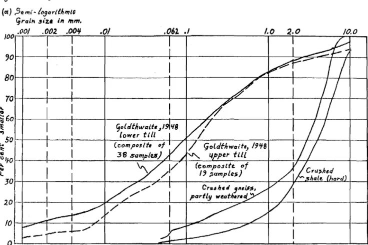
The grain size distribution of crushed rock conforms to law s of probability and if plotted on a special type of graph paper (4)
will yie ld a straight line (Fig. 1). Variations occur if the rock is
heterogeneous (breaks between mineral grains rather than across them) so that the curve may consist of two or more straight lines
with different slopes. The slopes of the curves reflect controlling
properties of fragments in different size ranges; coarse fragments composed of a number of mineral grains may break along joints, bedding, or foliation planes; fragments containing portions of single crystals break in a way characteristic of the mineral concerned. Detritus subject to prolonged grinding at the base of the ice usually produces straight line curves with two segments, the coarser debris having the flatter curve.
Although straight-line curves can be plotted from products of chemical weathering as well as crushing, they are not characteristic
of sediments sorted by water or wind. Thus it is possible to recognize
most tills formed directly by comminution of rock by plotting their grain size distribution on Rosin and Rammler' s "law of crushing"
paper (Fig. l(b)). Rock detritus melted from the surface of the
glacier loses some fines by meltwater transportation, and different lithologies become mixed in the course of deposition so that till originating on the surface of the ice may not have the "crushing" type of grain size distribution (Fig. 1, upper tills).
Soils picked up by glaciers, but not created by them, may
be mixed with other soils during glacial transport. The grain size
distributions of the resulting tills are caused by mixing or sorting by selective erosion and deposition rather than by comminution
(Fig. 1 (b», Krumbein, upper till). Deposition of Till
Currently two types of till are recognized (2) (3). Ablation till accumulates on the surface of the ice when englacial debris melts out, and grows thicker as more debris collects at the bottom; as the glacier decays the ablation till is slowly lowered to the
ground. Lodgment till is thought tobe "plastered" onto the ground
beneath the moving glacier in small increments as the basal ice
melts. Ablation till is recognized by abundant large stones that are
angular and not striated; the proportion of sand and gravel is high and clay is present only in small amounts (usually less than .10 per
cent). Because the texture is loose, ablation till oxidizes rapidly
and commonly is brown or yellowish-brown. In contrast, lodgment
till contains fewer stones which are srn a l'l e r than those in ablation till and are rounded and striated; the proportion of silt and clay is
relatively high (clay 15 to 40 per cent). Lodgment till is very
compact and is generally .cr ud ely fissile. It is practically impermeable
and oxidizes very slowly so that it is usually grey. The density of
some tills interpreted as ablation tills in New Hampshire averages 132. 0 pcf for 19 samples as compared with 137. 2 pcf for 38 samples of lodgment till.
The information now available justifies some modification of the ablation-lodgment till concept, at least to the extent of further
working hypotheses. The explanation of the uppermost till as
super-glacial till is satisfactory but the term ablation (chiefly melting but also evaporation) needs qualification for reasons that will be apparent.
Englacial debris has been observed mainly in the lower
one or two hundred feet of glaciers. In this zone rock detritus may
comprise as much as 10 or 20 percent, by volume, of the glacier. Basal melting is very slow; most estimates are substantially less than 2 inches per annum, compared with roughly 40 feet or more of
9
-once a layer of superglacial till has begun to accumulate and basal
melting becomes proportionately more important. An appreciable
thickness of englacial drift can be melted out from the base of a
till-covered glacier. In this till certain structures of the glacier
may be preserved though distorted because of a reduction in volume
of 70 to 90 per cent. The structures include sheets of precompressed
till a few inches thick formed in the thrust planes that dip upstr e arn near the glacier margin, and the statistically preferred orientations
of elongate stones. An orientation transverse to the direction of ice
flow develops among particles that are moved isolated from each
other for a prolonged period. Preferred orientations parallel to the
direction of ice flow develop near the mar gins of a moving fluid, and
where the particles contact each other frequently. This" subglacial
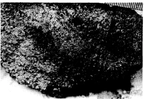
ablation till" may be somewhat precompressed by the overlying ice. Some of its constituent particles have been in contact with one another for an appreciable time and the average grain size is much smaller
than that of superglacial ti l I, Silt and clay particles expelled by ice
crystals form thin coatings around pebbles and larger stones, and
voids are abundant among sand-sized particles (Fig. 2). At the bas e
of this till layer striated boulder pavements or thin irregular lenses of sand and pebbles may occur as relicts of the last erosive movement of the ice.
The till layer below the" subglacial ablation till" might appropriately be termed "comminution till" as it appears to be manufactured more or less in situ by the glacier rather than picked
up and redeposited by it. Goldthwaite (5) suggested that the densities
of tills in New Hampshire were related to the water content during deposition rather than to the load of overlying ice as geologists have
supposed. This view militates against the theory of lodgm.ent till
forming by melting out of basal ice because the amount of water produced by melting is ordinarily many times the amount required for compaction to the maximum density; most of these tills are practically impermeable so that escape of all the excess water by
seepage is unlikely. Analysis of the energy involved in producing a
compact till by crushing and grinding rock beneath the glacier shows that the heat produced is just adequate to melt enough ice to form
about 8 per cent water. This is approximately the median value
required to obtain maximum density by artificial compaction in the
at the base of the ice by the shearing action of the moving glacier generates the proper amount of water for maximum density by melting some of the basal ice; thus the system maintains
thermo-dynamic equilibrium. This type of till does not become englacial
but is created and deposited at the base of the ice. The constituent
particles are oriented in the position of least resistance by the
shearing action of moving ice. Pebbles have their long axes in
the direction of ice movement and small silt-sized tabular particles lie more or less horizontal or parallel to surfaces of larger particles,
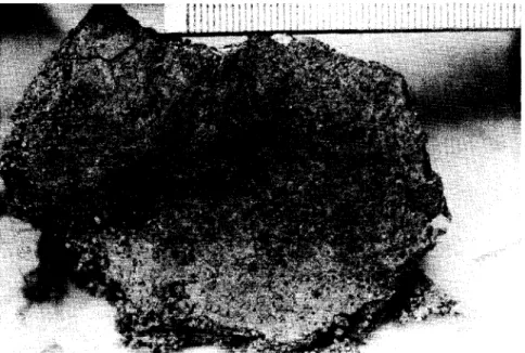
fanning microfoliation. Stones in comminution till are surrounded
by a compact matrix with a high concentration of fines formed by
abrasion of their surfaces (Fig. 3). The voids found in ablation
tills do not exist in comminution till. The grain size distributions
fit the law of crushing (Fig. 1, lower tills).
Comminution till is derived from crystalline rocks that
yield heat as surface ener gy on crushing. Certain clastic rocks
such as sandstone, siltstone, and soft shale can not form dense
comminution tills because the surfaces of the particles are not newly created by the glacier, with transformation into heat of work done
in crushing. The acquisition and transport of these materials is a
matter of deformation rather than crushing. These rocks are porous
and some i.ni.t ia ll.y contain more water than required for maximum density if crushing reduced the particles to sizes smaller than the
original grain size of the rock. Hence these formations may yield
soft tills. These soft tills also form from soils and they may be
overlain by more compact tills derived from crystalline rocks upstream.
In summary, till sheets comprise one or more layers of different types of till, not all of which are likely to be found in
anyone locality. Shrinking and reconstitution of an ice sheet can
complicate the sequence. The layers are listed in order from top
to
bottom:-(a) Super glacial ablation till;
(Thin lenses of sand and gravel of irregular di stribution)
11
-(b) Subglacial ablation till;
(Striated boulder pavements, layers of stones, thin lenses of sand of irregular distribution)
-(c) Comminution till; (d) Deformation till; (e) Bedrock.
Till (a) is "ablation till" of current geological usage; tills (b) and (c) are now generally called "lodgment till" and till (d) is the "soft till" recognized by engineer s ,
Structures In Till
Although till appears to be an unorganized material on casual observation, it may have several structures that affect its
strength and permeability. These include the parallel orientations
of silt and clay size particles (microfoliation) and the statistically preferred orientation of the long axes of particles lar ger than the
matrix, generally
in
the direction of ice flow. The random scatteringof stones is sometimes called "raisin cake structure". Close inspection
of a till face (Fig. 3) may show that many particles are aligned in rude
rows rather than in a haphazard manner. Fissility is the tendency
for till to split into irregular lenticular flakes, ranging from less than a millimeter thick in clay tills to several centiIneters thick in
sandy tills. Some tills are separated into beds a meter or two thick
by compact layers of sand and silt about a centimeter thick. Small
irregular distorted bodies of sand and silt have been termed "flame
structure". Joints commonly extend obliquely through massive,
clayey tills; some may be caused by shearing and others by desiccation
after deposition. Some joints contain thin layers of compact sand.
Lar ge irregular mas s e s of sand and gravel occur in unpredictable
profusion. Some of these are interconnected, as is shown by the
behaviour of groundwater, but many are isolated. Lithology of Till
12
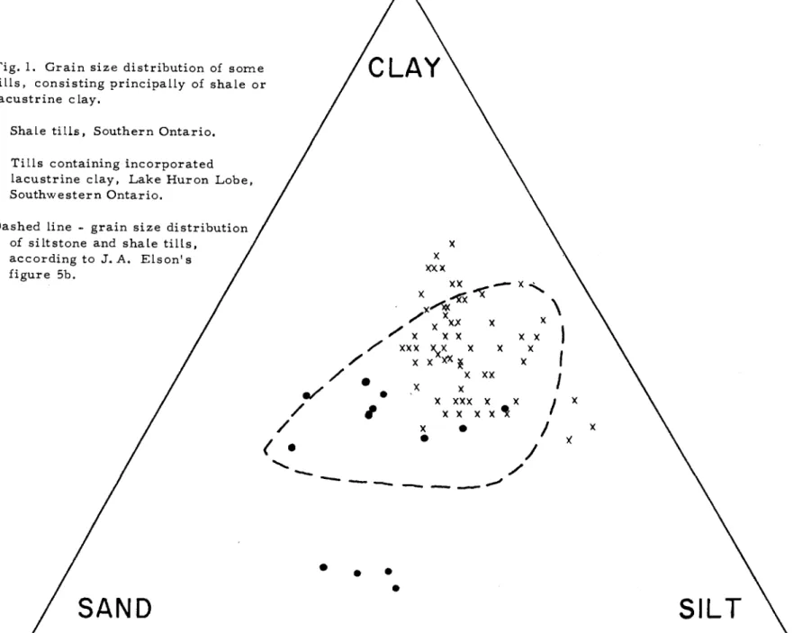
-distribution on a ternary diagram of more than 500 published till analyses (Fig. 4).
Some results are available on the relation of grain size distribution to the dominant rock types comprising tills (Fig. 5). In general, rocks that are easily abraded, such as limestone, dolomite, siltstone, shale and slate, produce fine-grained tills. While results are not available, it is inferred that slate and shale tills are rich in day minerals and therefore are more plastic than
other tills. Mineral composition influences the natural moisture
content which is slightly higher in tills containing appreciable
quantities of clay rrri.ne r aLs or rrric.a, The dry densities of tills
decrease roughly in the order: limestone (densest), slaty schists, crystalline-schist, and granitic till (least dense).
The underlying bedrock usually constitutes up to about 80 per cent of basal tills, depending on its resistance to abrasion
and plucking. As the glacier moves across belts of different rock
the drift is flooded with it in a short distance. The proportion of
soft detritus decreases rapidly once an area of soft rock is passed and more resistant minerals, especially quartz, that characterized
the till upstream may dominate downstream again. Upper tills have
a high proportion of far-travelled material and may not contain any of the local bedrock.
Other Properties of Tills
Most of the literature on tills emphasizes either the geological or engineering aspects but not both and there is still little
basis for collating the two points of view. An exampl e is the
Shand Darn study by Legget (6). He found some till there to be
abnormally dense, but the anomaly is reduced if the till contains mainly calcareous minerals, as seems likely, and the appropriate
(higher) specific gravity is used in his calculations. If his results
on permeability are plotted against a size factor (7), the tills fall into two groups: one has permeabilities less than 0.033 cu. ft/ sq.
ft/year at unit gradient, and permeability shows no relation to median
grain size. In the second group permeability increases from 0.05 to
O.25 units, as the median grain size increases. A logical inference
is that the permeable soil is ablation till and the less permeable soil is comminution till.
13
-Acknow ledgment
Practical limitations preclude the listing of about 200
references consulted in preparing this paper. The author regrets
the necessity to limit the references to the more general and practical considerations.
References
1. Crosby, 'W. 0., Englacial Drift; Am. Geologist, Vol. 17,
pp. 203-234, 1896.
2. Charlesworth, J. K., The Quaternary Era; London, Edward Arnold. Ch. 18, "Boulder Clay", pp. 376-399, 1957. 3. Flint, R. F., Glacial and Pleistocene Geology; New York,
John Wiley &: Sons. Ch.7, pp. 108-135, 1957.
4. Ge e r. M. R., and Yancey, H. F., Expression and Interpretation
of the Size Composition of Coal; Am. Inst. Mining &: Met.
Engrs., Trans., Vol. 130, pp. 250-269, 1938. 5. Goldthwaite, Lawrence., Glacial Till in New Hampshire;
Min. Resources Survey, New Hampshire State Planning
&: Development Comm., Pt. 10, 1948.
6. Legget, R. F., An Engineering Study of Glacial Drift for an Earth Darn near Fergus, Ontario; Econ. Geology, Vol. 37, pp. 531- 556, 1942.
7. Shepps, V. C., "Size Factors" - A Means of Analysis of Data from Textural Studies of Till; Jour. Sedimentary Petrology,
Vol. 28, pp. 482-485, 1958.
1.0 Crulr_' LLLNゥセDQ part!.!! weath.,.c/ .061
.t
セdサ rltltwQlte, I lower till (compos It. IIf3
e
SQmpleJI)"\
1/
/
.01 20iMエMMエMMMKMMセGMMMZセMMMMMGMMエMMセMMセ」MMMK⦅⦅t⦅MNMMMMMK⦅⦅Q"-•
)j
6 o t - + - - " - - - + - - - - t - - - t - - + - - + f ' - - - t - - - t - - - - f - - f - - t - - 1 セ..,
SoャMKMMMMQイMMKMMM⦅エ⦅セM]MMZNNNM⦅⦅Z⦅⦅セ⦅エ⦅MMMa⦅⦅⦅tGMMMMMMM⦅K⦅MMK⦅⦅⦅⦅NヲMMMjヲMMMMi⦅⦅セ セ..
セ III u'fO MKMMMKMMMMMLNMMMMMQiMMMMセMセMGMMMfKMMMMNLNセNNNlNNZNMLNMM⦅⦅⦅Z⦅M⦅KMMGZKM⦅ヲ⦅MMM⦅エ⦅セ"
セ
joゥMエMMMNMMMMャMMM⦅KMMMMMLNcMセ⦅⦅ゥM⦅エ⦅MMMMGMMMMK⦅セ⦅⦅QGセ]]MZセセK⦅セ80
10エMKM]LNNMZZZZ[NエMMMM[MMMMMZiBMGMエMMMMMMM[MMM「LNNM[MMMMMMMZセMK⦅MMエMMMMM⦅エM⦅Q ?Or+---+----,r----t---+--i---\---7::7.-s:-'=-I---1-f--1 7 0 r + - - t - - - - + - - - - t - - - + - - + - - - y L . . . - - - - t - - - - ' - - - - f - _ f _ - t - - 1Figure
1.
Grain-:; iz e
dtsirt
buttons.
(Ol) ?QI1liMャッY。イャャOGGGGiセ
c;raifl siU lit ",m. /00 .001 .002. Nooセ
OLL_-L_l.--_-L
セ、ZZZZZZャZ]⦅ __L_ __i_ _L___I10.0 2.0
/.(J
./
YUQMKMMWMMNN]NNNNLNMZMMMMKMMMMMM|KMMQMMMMMNZZセMMMM⦅⦅⦅K⦅M⦅⦅⦅⦅ZGMMMMMM⦅ェMMエ
(b) ャセ[Bエャャィ
&.
Ram",I., "lawof
crus"''',''
Grainsize. in mm.
99 .001 .002. .00'1- .0/I
I
-,
I
Gセ
I
,ola'tAlalte, ャTGセGB tillI
LNNYPャMKMMセセNNNNZZ[NM⦅LMNM⦅GイK⦅MMMMM⦅イMNNNーッNLセMMMMMNZセMMK⦅MMKMMMM⦅⦅⦅エM⦅ャ
セ \JセboエBMイMMGMMMMMー^BBG[ZMセZエMMセMZZKMMMMGMMMMKMMMMセL[[ZZMMMMTセMセMMMMKMMMMャ
..
lro
'"
セVPQMMエMMKMセMャMMMMMKMMセZ]MMNNNML[ZBB、セイZMiMMMMMMMMKMMセ ...::ll".,---f---l セsohMMKMMMGゥMッZッZZM]MMMKセセセMLNMZセセセセZMMMMMMMNNNNNjMMNMMMKMセLMMMMMMKMMMMャ セNiヲ oエMKMMNMMMMMMKMMMMMGォZMMMG]セセZN]NNNMMMャiMMM⦅ヲBG⦅NNNZZGセNNNNNNLNNNNNNMMMMKMMMMKMセカtMMMMMMャ セjohMM⦅イ⦅MKMMMMKMMM]ZZNNNNNNNNN[[[⦅Z⦅MMMMMェイMKMMセセセZ⦅⦅MMKMMMKMMMMカセMMェM⦅⦅⦅⦅Q"
セRPエ⦅エ⦅MMNMM⦅⦅イMM⦅K⦅MMMM]セ⦅⦅]ᄆMMMMMMMNZZjZZセセ[[ZZZ⦅⦅⦅⦅⦅KMMセZtM⦅⦅⦅⦅ゥMMMエ ioエMエMMMMQMMエMMMMエMMセMMM]MNNZNNNNMMMKMMiMMMMセMM⦅NN __]セM⦅イ⦅⦅NNNZZN]⦅NセセZMエMMエ UhMMMゥMMエMMMMKMMMMMMKMMエMMMMMMMMKMMMKMMMMセ、⦅MMエ I'15
-Fig. 2. A close view of the till surface that was against a stone in
sandy "basal ablation till". A thin layer of silt, formed by
expulsion of fines from glacier ice crystals, coated the stone.
Remnants of the silt coating show shrinkage cracks. The
open texture of the till outside the coating is visible. The
16
-Fig. 3. A close view of the till surface that was against a stone in
sandy "comminution till". A dense matrix of silt derived
from the stone by abrasion fills the interstices. Some
sand grains show a linear arrangement. A few loose
fragments are seen on the lower and left parts of the
17
-b.
S
cャGNjセウイ・エャ11"4"'-SiZ.e. c{assiru.fi,,"t 01 till:;. Cia!!
...
... :" ". '..
,
/ .. 1 / /.
':',
\.'- - _.:-.:.--1 :Sa.nd セゥャエ b. ZUゥOエヲ^エエjィセ セ セャエ。NG・--
... / /. :) /' / / " / / ' . : / /..: . / / . / /...
'.--Fif)ure"". Q. (jrain-:;iz.e. di;;trt/Juti"'17 of
(0.0011'" about" 500 till
(clolj )
analyJes.
セアョア :Silt
a.
Li.mef,to"e &, d.olomi.te).06mm
Hセ。ヲWHj &jt"QveL)
Number of ana'Jse.s per
o.s
セ"f
a1C.:o
0
1-2,0
3-5k;';'·::[
6-/0 セ /I-/Sm
/6
-20m ?Clnd&-fjravel / ... / .... / .. , .,
r > :" ) »: .' .'. .;-/ » < " / .','"
.: " » > ?O/fd ?dfd. Harcl :;;hale
&
::slede.Clay %alfd eo セ ranitotd roclr$ ".-:"', /,: '. \
.r:':
セ / ,.'.'.
) -, " : I,J. -, ;I' ;:,anelDiscussion by F. L. Peckover
Soil engineers tend to view till as a heterogeneous
rn i xtu r e of soil grains including r a.nd om lenses of unifo rrnly graded
rna.t e r i a l , generally b e c orning rn o r e dense with depth. Dr. Elson
has explained these variations which occur in till and has bridged a gap between geological and engineering i nfo r m at io n on soils.
SOITle of the points rn a.d e in the paper rnay be illustrated
by results collected in a c ornb i n ed engineering and geological study
of certain ti lls along the St. Lawrence Valley in 1957. This study
was rn a.d e with Dr. Elson's enc ou r a g ern ent to gain a broader
under-standing of some construction p r ob l ern s involved. Engineering
classification tests were suppl ern ent ed by s irnp le geological studies of till at four locations, three in the vicinity of Montreal and one
upstream fr OITl Cornwall. The se are designated, in order of occurrence
up st r e am , as Sites I to 4, inclusive. The results collected are
surnrna r i z ed in Table I.
Pebble orientation and till pebble counts have been
rn enti oried in the paper. Pebble orientation is studied by rn e a su ring
the az irrruth s of long axes of pebbles and applying statistical analysis. It is significant in indicating the probable direction of flow of an ice
sheet. Pebble counts are rn a d e by choosing pebbles f r orn the soil
in situ in a syst ernati c way and classifying th ern according to rock
types. It is significant in identifying the source and type of till.
The direction of striae are of course rn e a s u r e d directly, where apparent on the surface of bedrock.
No att ernpt will be rn a.d e to clas sify the rn at e r i a l s in
Table I as ablation or lodgment tills on the basis of the results shown. The results are of SOITle interest f r orn both a geological
and an engineering point of view. Striae at Site 4 and pebble
orientation in the tills near Montreal all indicate a direction of ice flow f r orn northeast to southwest, or generally up st r eam along the
St. Lawrence valley. This ice sheet deposited dense grey sandy
silty till on bedrock. MacClintock (I) has called this the Malone till
sheet. As interpreted by Dr. Elson, a fresh water lake was darnrn ed
19
-were laid down. These deposits were for the most part picked up
again by a readvance of the glacier and redeposited as silty till. Near Site 3, separate deposits of varved clay-silt and fine sand are in fact found, the clay-silt being almost unbelievably
contorted, probably due to the overriding ice. This phenomenon
raised serious doubts about the soil sampling technique used in test borings until a test pit was dug and the material exposed.
In the international rapids section of the river, according to MacClintock, a recession of the ice with some readvancing and overriding of outwash took place, accounting for the middle till
observed at Site 4. After the Malone ice had melted, a new sheet
called the Fort Covington advanced from the northwest and is usually
taken to account for the upper till in the Cornwall-Iroquois area. As
seen from data in the table, however, the results of pebble counts seem to show a closer association between the middle and upper till than between the middle and lower tills.
The pebble counts in the table illustrate two comments of
Dr. Elson. He notes the persistence of quartz pebbles in being carried
far in tills. This is particularly noticeable at Site 4, the lower till
having a combined Precambrian and igneous pebble content of 370/0 in spite of the 65-mile distance separating this location from the limit of
the Canadian Shield in the direction from which ice advanced. The local
rock at Site 4 includes limestone and dolomite (34%) with shale and
sandstone (29%) exposed a short distance to the northeast. To the
northwest, the direction from which the upper ice sheet is presumed to have advanced, limestone and dolomite (59%) predominate for a
considerable distance. The percentages in brackets denote pebble
content in the respective tills.
At Sites 1 and 2 near Montreal, shale with igneous
intrusions and some sandstones are the predominant bedrock materials. The high proportion of shale pebbles (average of 83%) at Site 2 as
compared with Site 1 is unaccounted for. At Site 3 the bedrock has
changed to limestone but the boundary with shale is only about one
mile away in the direction from which the ice came. Dr. Elson's
statement, that a glacier pas sing over a new rock type is flooded with the new material in a short distance, is vividly shown by the proportion of limestone pebbles at Site 3, almost unaccountably so
20
-in the case of the lower till. The nearest P'r e c arnb r i an rock to the
northeast is about 70 or 80 miles fr om these locations.
The geological portion of these studies is significant
fr om the engineering point of view in that it did irrrp r ov e understanding
of the engineering behaviour of the deposits in a way which was not
possible by engineering studies alone. Three c ornpar i s orrs of results
in the table will illustrate
this:(1) Till at Site 1 v s , lower till at Site 2
-Both these tills are unweathered with s irni la r
grain size, natural density, water content, and laboratory c om pac ti on characteristics, and yet differences in
excavation and field cornpacti cn operations were noted.
After pebble counts were m ade , it was realized that these differences were probably due to the rnu ch different
proportions of shale and other rock particles in the two soils.
(2) Upper till v s , lower till at Site 2
-These tills are of the s arn e o rigm as shown by the
s irni la r results of grain size and pebble counts. However,
the upper till has apparently been altered, cherni ca lly by
weathering and physically by reworking (probably by river
action destroying the orientation of the grains). The
differences in the natural density and water content are seen, and the variation which arose in laboratory and
field c orn paction characteristics were not therefore
unexpected in spite of the c ornrn on origin of the rn a.t e r i a l s , (3) Upper till at Site 2 v s , upper till at Site 3
-Although present side by side in the field and s irni la r in natural density, water content and laboratory c ornpacti on characteristics, these two tills are of different origin as
shown by grain size and pebble counts. Observed differences
in excavation and c ornpac ti on characteristics were a s surn ed to be a reflection of these differences.
21
-The geological studies presented here were made at the suggestion of Dr. Elson by Mr. R. Notki n , summer student in geology. under the direct supervision of Mr. T. G. Tustin, Soil Engineer with
the St. Lawrence Seaway Authority. The author was also associated
with the St. Lawrence Seaway Authority at that time.
Glacial till is a source of many problems particularly
when mass excavation is involved. Large boulders may present a
problem in upper (ablation) tills. high densities in lower (lodgment)
tills. Both characteristics give warning that such equipment as
shovels and trucks may be more economical excavation tools than
self-propelled scrapers. Many tills seem to harden on exposure and
drying, perhaps due to the cementing action of chemicals dissolved
in the pore water. Blasting, or ripping if scrapers are used, is
necessary for excavation in some cases.
Many contractors bidding on large excavation jobs in till
do not investigate thoroughly the evidence available to them. A
contractor's understanding of excavation problems in till is greatly improved if the contract documents include representative values of the in-place density of the material, the number of blows found in
standard penetration tests. and particular mention of boulders if
present. Mere description of till as a dense mixture of sand, silt
and clay is not sufficient.
Comparative Geological and Engineering Study of St. Lawrence Valley Tills
Grain Size Moi sture-Density
(%) Relationships Pebble Counts
セ ....; H >, セ '+-< >,C ilJ HC セ c セ H U ...
-
o
U'"
BGセ • .-< rn ッセ c,S
g
ilJ ;... Site Ti II rn セセ Xセ Direction >:: !l! ..Q 0 ilJ >:: セセ ilJ ---< >, ---< ... ;j >, ;j U ..., 0 r< (JJ Description >:: ilJ'"
... '" >:: Bedrock of Pebble ... • .-< i=: セ NセS
H rn r< ... セ セ rn H ..-< H ilJ i=: rn,..
(JJ ("jH ::l rn ;j ... ilJ ilJ I-< 0
U --0 ·Z >:: セ ilJ Striae Orientation セ 0 --0 U
'"
... >:: ... >::8
:,) • .-< >:: .::: '" ilJ '" 0「セ
'"
セ >:: ilJ r< ..c: 0'"
• .-<p';d
..c: • .-< 0 ro H Eo-< U U) U)zo zu
U) セ Q U) 0.. cc セ H '::)W near base,1 unweathered 9- 25 40 35 132 11 133 8 sh a l-e none le s s pr onounc Ed 48 18 10 2 13 8
12 near top
upper weathered, 10 30 30 40 113 17 118 13 no trend 78 2 1 4 9 6
reworked
2 shale none
lower 8 33 33 34 132 11 130 9 SW 87 5 4 0 1 3
unweathered
upper weathered 30 10 251 56 115 16 118 13 roughly SW 30 48 2 3 6 5
3 lower lim.e stone
-
-unweathered 10
-
-
-
-
-
-
-
--
0 94 0 0 1 5I I
upper weathered 20
-
-
-
136 8 133 8 no trend 8 24 35 14 12 7m.iddle
glacio-71
4 fluvial 20 4 72 24 136
-
-
dolom.ite S. 45oW.- -
3 22 50 15 12 1I I lower I unweathered 20 26 35 1 38 134 8 _.
-
no trend 15 ft 4 14 20 25 25 12 above bedrock23
-Discussion by A. Dreimanis
While studying grain size distribution of tills of southern Ontario, I noticed that some of the tills which were derived principally
from shale were coarser textured (less clayey) than Dr. Elson's. I
found also that some of the clayey or silty tills, rich in shale fragments, did fit in the upper right side of Elson's field of shale tills of Fig. 5b, but these tills (from the Lake Erie basin) contained also incorporated
older lacustrine clays and silts. The crosses of the ternary diagram
(Fig. 1) represent grain size distribution of clayey and silty upper tills of the Lake Huron lobe, where shale is relatively rare in the pebble grade, and where field evidence suggests considerable
incorporation of lacustrine clays in the till. Thus it may be that the
tills represented in the upper right half of the Elson's 5b field, have been derived partly from glacially reworked lacustrine deposits. Dr. Elson points out while discussing results of artificial crushing of shale that it does not necessarily produce more fines than harder
rocks in the first crushing operation. If experiments of prolonged
crushing could be. arranged so that they simulate conditions in the glacier, the proper grain size of shale till ( and other tills) could be determined at various distances from the source rock.
Returning to the older soils (lacustrine deposits) as source of till, I would like to emphasize that considerable proportion of tills, not only clayey, but also sandy and gravelly, depend in their texture more upon incorporated local older soils than bedrock fragments, eo g. the clayey tills of the Lake Huron and Lake Erie basins, the sandy tills of the Paris-Guelph area, the silty upper till of the Lake Simcoe basin, etc.
Fig. 1. Grain size distribution of some tiLLs, consisting principaLLy of shale or lacustrine clay.
SIL T
•
•
•
•
x Xxxx
XX"'X -
x <, XIHセ セ \ , / Xxx X x , / X X X X XXI
, / XXX \X X X X , . / xxxxセ X/
X XXI
•
e/
X X•
X XXX X , XI
X/
,
X X X X/
X•
I
X•
)((
•
/
<,./
-
MMMMMMセ
SAND
• Shale tills, Southern Ontario. x Tills containing incorporated
lacustrine clay, Lake Huron Lobe, Southwestern Ontario.
Dashed Line - grain size distribution of siltstone and shale tills,
according to J. A. Elson's figure 5b.
25
-Discussion by R. Thurber, H. Nasmith and A. E. Insley
Dr. Elson is to be congratulated for his work in gathering together information and writing this paper on a subject which still
requires a great deal of study. With regard to his discussion of
pore pressures in glacial action, it may be of value to add some results of observations made in British Columbia.
Pore water pressure can bring about the failure of a
glacial ice darn. When the level of the water impounded by the
glacier reaches an elevation equal to about nine-tenths of the thickness of the ice-darn, the pore water pressure on the base of the ice is equal
to or slightly greater than the weight of the overlying ice. Water is
then able to force its way beneath the ice-darn under the full hydrostatic
head developed from the impounded lake. Channels beneath the ice
are enlarged and the rate of flow rapidly increases until the lake has
been drained. The channels are then closed by plastic flow of glacial
ice and the lake fills again until the water reaches a critical level to produce a repetition of the flood.
This mechanism was first described in connection with
catastrophic floods from glaciers in Iceland(2). Floods on the Taku
River in Northern British Columbia described by Kerr (3) are probably
of this type. Fluctuations in the level of Tide Lake in British Columbia,
from which the lake derived its name, were probably the result of periodic drainage under the terminus of Frankmackie Glacier which
for some time acted as a darn across the outlet of the lake (4). Each
year for the past three years, flooding has occurred on the Bear River northeast of Stewart, B. C., when Strohn Lake drains rapidly under the Bear River glacier into the Bear River.
These floods are the result of an ice darn failure caused by pore water pressure without any associated volcanic activity.
26
-Discussion by 3. R. Clark
This discussion is based on the soil geology exposure
below the spillway at Smoky Falls. Smoky Falls is located on the
Mattugami River about 50 miles north of Kapuskasing. In this soil
exposure there is a variety of glacial material similar to that d i s c u s s e d by Dr. Elson.
The lower till is a very dense silt with considerable sand and gravel, s orn e cobbles and boulders and is believed to be a
lodgrnent till of early Wisconsin Age (Photo I). There is no evidence
of non-glacial, organic rnaterial under the lower till and the contact between the lower till and the bedrock is very tight.
Ablation till overlies the lower till in part of the exposure. Faintly layered outwash sands and gravels, and in part of the exposure, fine sand and silt, overlie the ablation till, or where the latter is
absent, lie directly over the lower til.l, There is a sharp break
between the outwash sands and gravels and the fine- grained upper till, whereas the contact between the upper till and under lying outwash silts
is often difficult to deterrnine (Photo I). The upper till is believed to
be of Cochrane age. This exposure appears to be about four miles
south of the northern boundary of the Cochrane r e a dv a nc e ,
In Photo 2, is shown a three-foot thick inclusion of silica
sand within the lower ti l l , Preswnably the early Wisconsin glacier
in its southern rnovernent incorporated the silica sand found at the northern lirnit of the Precarnbrian shield, which here is about seven rniles north of Srnoky Falls.
Photo 3 is a close-up of the ablation till showing the very
coarse-grained' nature of the rnaterial. This, together with the
presence of groundwater seeping through the ablation till and the loose
nature in place, indicate a normally-consolidated till. In part of the
exposure, the ablation till was found over the silica sand rather than over the lower till.
Photo 4, which was taken about 30 feet downstream of
Photo 3, shows the limited extent of the ablation till. Outwash sands
27
-seeps through the sand and gravel and runs down the face of the very
dense lower till. Movement in the lower till, presumably after
deposition, has resulted in joints of various length and direction. I hope these photos help to illustrate and confirm some of the many aspects of glacial tills discussed by Dr. Elson.
28
-Photo 1
Phvto 3
29
Discussion by G. C. McRostie
I would like to congratulate the author on the presentation
of a very us eful paper. It will provide background for many decisions
based on borehole data.
For engineering purposes it would be useful to be able to
distinguish definitely between lodgment and ablation tills. Could
Dr. Elson comment on whether this is likely to be achieved by
examining particle shapes? Although the question is asked, there is
some doubt about an affirmative answer for the reasons illustrated by
the following figures. A glacial till was examined and found to have
dry densitie s varying from 1Z9 to 145 lb/ ft 3. There were insufficient
determinations to make a statistical analysis and compare modes with
the authorrs suggested distinctive modes for the ablation and lodgment
tills. Particles in the size range from 1/3Z" to l/Z" were classified
with respect to sphericity as varying from high to low and with respect
to roundness as varying from very angular to sub-round. The majority
were sub-angular (5) (6).
In a further attempt to assess the criteria for distinguishing
ablation till, the grain sizes from samples of the till deposit mentioned above were plotted on the special graph paper in Dr. Elson's Fig. 4. Contrary to the findings of the author, the loose, generally sub-angular till plotted as a straight line not a wavy line; however, the dense tills from the same deposit plotted as reasonably straight lines.
Finally, could Dr. Elson comment on his choice of grain
size dividing silt and clay at 0.004 rnrn , in Fig. 5? This does not
agree with any of the widely used engineering divisions and might needlessly add confusion.
31
-Discussion by D. F. Coates
Dr. Elson is to be congratulated on an excellent paper. The genesis of two principal types of glacial till are suggested
together with the variations that can occur in these types. The
practising engineer in attempting to extrapolate results from point sources obtained in test borings is greatly as sisted by having such concepts formulated.
Dr. Elson mentions the presence of streams flowing
on, in and under glaciers. This feature warrants additional emphasis
owing to the engineering implications. The amount of stream activity
in the vicinity of a glacier is great and consequently it is to be expected
that glacial tills would include many stream deposits. It could also
be expected that ablation tills would include lake deposits when it is recognized that a lake is merely part of a stream and results from a
particular topography. Thus it should be expected that lacustrine
clays and silts as well as alluvial sands and gravels could be found in
tills with properties quite distinct from the well-graded matrix. This
clearly is important when planning foundations for structures and dikes for retaining reservoirs.
Dr. Elson gives a description of a typical ablation till. This description describes the upper till at Cornwall very well except
for the term "loose t extu r e ", It would be useful to have Dr. Elson's
definition of this phrase. The Cornwall upper tills with their high
density and their high resistance to standard penetration samplers would not normally be described as having a loose texture.
In Dr. Elson's description of the flcomposition of a till
she et " it is suggested that the range of thicknesses of the various elements be increased to provide for a maximum thickness of about
40' for both the ablation till and the lodgment till. The description
would then include the deposits in the Cornwall area.
In postulating a reason for the high density of the lodgment till, the mechanisms of ice being melted by heat released from crushing and the resultant water being adsorbed by the mineral surfaces are
included. It is then suggested that these two factors have a necessary
interesting if Dr. Elson could amplify on this poi nt , The crushing ener gy for quartz would be relatively high, consequently yielding a relatively large amount of heat and thus a relatively large amount of
melted water. However, the crushed quartz would only adsorb
relatively small amounts of water. In contrast minerals producing
clay-like or related minerals would have a relatively low amount of heat released by crushing but would adsorb relatively large amounts of water.
Some difficulties were encountered during construction of
the Seaway in classifying some of the material as rock or soil. It
has been claimed that the till was comented which would then qualify it
as rock. It would be of interest to have Dr. Elson's comments on this
poi nt ,
Reply to Comments and Closure by 3. A. Elson
Most geologists assume that ice pressure is the cause of the high density of lodgment till and are probably unaware of all the
conditions requisite for precompression. Few have had courses in
soil mechanics and most have naive ideas on the compaction of sediments. just as many engineers are probably unaware of the
relationship of mineralogy and source rocks. The former seeks to
interpret geologic history. the latter to under stand the properties of
materials for practical use. The two approaches are entirely different.
Till is deposited mainly near the margins of ice sheets where the ice is relatively thin (perhaps a few hundred feet thick as
compared to 5,000 to 10,000 feet near centres of accumulation). The
effective stress of glacier ice is probably greatly reduced by
inter-stitial water in the ice. One theory of movement is that the crystals
melt due to pressure at points of contact and the water migrates to
adjacent crystals and refreezes. Thus, plastically deforming ice of
a temperate glacier is continually saturated. Its porosity is a fraction
of one per cent. This pore water occupies all but the brittle crust,
which is 150 to 200 feet thick, and should provide high neutral pres sure
if this theory of movement holds. Many tills are overridden by later
33
-further where drainage pe r mit s , The effective stress of glaciers is
a virgin field for research.
Arching ordinarily can not occur at the base of ice rn o r e
than about 150 feet thick. Under these pressures the ice is plastic
and c o nfo r m s to all irregularities in the floor. Tunnels cut in ice
at these depths gradually close. Exp er irn e nta l work has shown that
under high pressures ice has practically no cohesion.
Probably too rnu ch ernpha sis is placed on the as sociation
of p e r.rna.nently frozen ground with glaciation. The two occur together
in the Arctic and Sub-Arctic, but over wide areas the continental ice
sheets advanced into areas with c l irnat e s that, up to the tirn e the
glacier s arrived, were only a few degrees cooler than at present. The only reason they did not continue advancing southward was that the c Iirnat e was so wa r-rn that they rn e It e d as fast as they advanced;
this c lirnat e was not conducive to the fo rrn ation of p e rrn afr o st. There
is local evidence that the ground was frozen near SOIYle ice rn a r gi ns
and fairly widespread evidence of p e r rriafr o st in highland areas, such
as the Appalachian Mountains in Pennsylvania and New York. However,
there has been little evidence in the fo r rn of fossil periglacial features
and tundra plants throughout rn o st of the Great Lakes region, though
srria l l patches of pez-rnafr o st IYlay have existed there. A glacier
advancing over tern pe r at e regions does not necessarily cause the
ground below it to freeze; because the heat flow s through ice only
half as fast as through rock, it is likely that the tern pe r atu r e of the
sub-glacial floor rises to the p r e s s u r e-cm e lting point of ice if it was
colder before it was overridden.
Mr. Peckover's results fr orn the St. Lawrence Valley
illustrate the effect
01
lithology on tills in that his shale tills havedensities of 132 lblft whereas the 」。セ「ッョ。エ・ エゥセャウ Hャゥiyャ・ウエッセ・ and
d o lorrrit e] range fr orn 134 to 136 lblft . The diff e r enc e rnight be
explained by rn i n e r a l.ogy alone. The results also suggest densities
of the related ablation till of about 115 lb/ft 3• If rn o r e figures were
available, a greater range in densities of ablation till than in lo dgrn ent till would be expected.
Professor Dr e irnarii s has added several points to rny
triangular d ia gr arn showing the grain size distribution of tills fo r rn e d
for all the main lithologies so that contours could be drawn to show the relative abundance of the different size-distributions, as I have
done for tills generally (Fig. 4). These triangular diagrams do not
mean that tills having the distributions shown are formed from certain rocks, but that certain rocks tend to produce certain grain
size distributions. There is obviously considerable overlapping of
these distributions. Professor Dreimanis has found by preliminary
trial that a till formed from lacustrine clay did not follow the law
of crushing curve whereas a till formed from shale did (oral communi-cation).
Mr. Coates raised a problem in semantics. The
expression "loose texture" was used by Warren Upham in 1891 and
is quoted by me. He undoubtedly referred to material that can easily
be handled by a shovel and that disaggregates in handling, whereas
dense till requires the use of a pickaxe and breaks in chunks. The
word "density" may be preferred to "texture" in accordance with NRC Tech. Memo 37, p. 5; however, "loose" is not a proper
adjective to modify "density". Also, "density" incorporates such
factors as the degree of compaction and the specific gravity of the
minerals and the term needed should eliminate the latter. The word
"compact", which is mainly concerned with void ratio, seems most suitable.
The dense upper tills at Cornwall could be basal ablation tills or supe:rglacial ablation tills that have been precompressed by
a later episode of glaciation. The permeable nature of ablation till
lends itself to such a;:tion. The second episode of glaciation need
not necessarily deposit an overlying layer of till; once the irregularities of the sub-glacial floor have been levelled off by erosion and deposition,
little material is picked up by glaciers for redeposition. The thicknesses
of tills in a single drift sheet suggested in my paper were intended to
suggest the relative thicknesses in orders of magnitude. To set any
definite limits for any of the elements would be most unwise as
tremendous local variations are common. These range from attentuated
drift borders where the till sheet is represented by only a few widely scattered boulders to other localities, generally in valleys lying
athwart the direction of ice flow, where the till is several hundred feet thick.
35
-Certain tills (comminution tills) of high density may have derived their water from the heat of crushing (comminution), but there are other sources for both heat and water; there is more apt to be an exc e s s rather than a deficiency of it for maximum
density. Most rocks are already saturated when overridden by
glaciers, and rocks composed of clay and related minerals (shales, mica schists, et c , ) already contain most of the water of adsorption
needed for their till product. Although the heat produced by crushing
these rocks is small, only the interstitial water need be formed by it. Some comminution tills from these rocks are not as dense as they might be because there was a deficiency or, in some cases (for example in porous sandstone) a surplus of water.
The majority of tills contain a surprising amount of quartz in the silt and clay fractions, even those tills we think of as
being limestone and shale. Our opinions are influenced by
macro-scopic inspection of the pebble fraction, but the bulk of the material, and certainly most of the surface area, is in the fraction smaller
than O. 2 rrirn , This fraction is commonly mainly quartz.
More serious objections than those raised by Mr. Coates arise from other sources of heat (geothermal heat) or heat and water
supplied by circulating groundwater. Heat from these sources has
time to dissipate but the heat of crushing is adiabatic and acts immediately.
References
1. MacClintock, P., Glacial Geology of the St. Lawrence Seaway and Power Projects, New York State Museum and Science Service, Albany, N. Y., 1958.
2. Thorarinsson, S., Geografiska Annaler, pp. 216-242, 1939.
3. Kerr, F. A. , Geological Survey of Canada, Memoir 248, 1948.
4. Mathews, W. H., University of British Columbia Interim Report on Tide Lake, 1957.
5. Aschenbrenner, B., A New Method of Expressing Particles
Sphericity, J. Sedimentary Petrology, Vol. 26, No.1,
1956.
6. Powers, M., A New Roundness Scale for Sedimentary Particles, J. Sedimentary Petrology, Vol. 23, No.2, 1953.
37
-Section 4
Tests on Glacial Till by
J.1. Adams
Since glacial till occurs widely in Ontario, its existence on many construction sites has special engineering significance. Till may consist of material almost all of clay size or it may be
chiefly cobbles, gravel and sand. More typically till is made up of
a mixture of materials ranging from boulders to clay. As most tills
were deposited by advancing ice sheets, the materials deposited are
usually highly over consolidated. Due to the very dense and impermeable
nature of many tills, the term "till" has earned the reputation of being an ideal material for foundations of heavy structures, earth dams and
for impervious rolled fill. In this paper some of these typical tills
will be described in terms of clear physical properties and shear
strength parameters. An account of the problems which have been
experienced in testing tills also will be given. In addition, comment
will be made on some tills which have been encountered which are not
ideal either as foundation or embankment material. Tills from two
locations in Ontario will be discussed. The locations are Cornwall
on the St. Lawrence River and Otter Rapids on the Abitibi River. Cornwall Ti II
The till encountered in the Cornwall area appear s at the surface in the form of ground moraine with ridge-like or drumlinoid
features. The till is also found underlying soft marine deposits of a
more recent age. The till is a very dense bouldery material with
approximately equal proportions of sand and silt and contains between
7 to 12 per cent clay sizes (0.002 rnrn}, The till is believed to be of
Wisconsin age and occurs in two sub-stages: 1) a lower till lying on bedrock and 2) an upper till usually separated from the lower till by
granular deposits or varved clay (1). The lower till is grey or
grey-blue in colour, very dense, and generally has a lower stone or boulder