Human Influences on Environmental Changes in The Kerkennah Archipelago (Tunisia) Since The 60's
Texte intégral
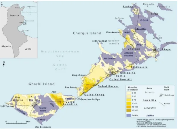
Figure

Documents relatifs
The deficit may be related to a change in summer mortality response, which may be due to public awareness of the dangers of high temperatures, the preventive measures
Table 4 shows the standardized DALY, YLL and YLD rates according to injury category for the two studied periods. One can observe a reduction in the YLD rates between the two
De plus, il y a le fait, lié sans doute, que, pour beaucoup, le racisme n'était pas, jusqu'il y a peu, un phénomène touchant la Suisse au même titre que les autres pays.. Le fait
Ainsi, nous pouvons tenir compte de l’analyse faite à propos des compétences sociales qui semblent aboutir à la même conclusion : à savoir que la taille et la
C’était le moment choisi par l’aïeul, […] pour réaliser le vœu si longtemps caressé d’ accroître son troupeau que les sècheresses, les épizoodies et la rouerie de
1) National policies and regulations. After the founding of new China, land reform is continuing and people share the land. People’s enthusiasm of labor is improved.
The estimated pumping rates in the northern (north Lebna dam), central (between Lebna dam and Korba) and southern part of the Korba aquifer in 2004 are 13, 22, and 12 Mm 3
The A4D results show that the Chagga display a profound attachment to their territory, the forest is the element creating social relations, technical progress
