HAL Id: hal-03193227
https://hal.archives-ouvertes.fr/hal-03193227
Submitted on 9 Apr 2021
HAL is a multi-disciplinary open access
archive for the deposit and dissemination of
sci-entific research documents, whether they are
pub-lished or not. The documents may come from
teaching and research institutions in France or
abroad, or from public or private research centers.
L’archive ouverte pluridisciplinaire HAL, est
destinée au dépôt et à la diffusion de documents
scientifiques de niveau recherche, publiés ou non,
émanant des établissements d’enseignement et de
recherche français ou étrangers, des laboratoires
publics ou privés.
Miocene magmatism and tectonics of the easternmost
sector of the Calama-Olacapato-El Toro fault system in
Central Andes at 24° S: Insights into the evolution of
the Eastern Cordillera
R. Mazzuoli, L. Vezzoli, R. Omarini, V. Acocella, A. Gioncada, M. Matteini,
A. Dini, H. Guillou, N. Hauser, A. Uttini, et al.
To cite this version:
R. Mazzuoli, L. Vezzoli, R. Omarini, V. Acocella, A. Gioncada, et al.. Miocene magmatism and
tectonics of the easternmost sector of the Calama-Olacapato-El Toro fault system in Central Andes at
24° S: Insights into the evolution of the Eastern Cordillera. Geological Society of America Bulletin,
Geological Society of America, 2008, 120 (11-12), pp.1493-1517. �10.1130/B26109.1�. �hal-03193227�
ABSTRACT
The Miocene Las Burras–Almagro– El Toro magmatic complex lies ~300 km to the east of the Central Andes volcanic arc, in the easternmost sector of the transverse Calama– Olacapato–El Toro fault zone. The magmatic rocks of the Las Burras–Almagro–El Toro complex comprise a monzogabbro to mon-zogranite laccolith like intrusion and basaltic andesite to dacite volcanic rocks that include seven lithostratigraphic members. New Rb-Sr dates indicate that the intrusive rocks are ca. 14 Ma, and K-Ar dates suggest emplace-ment ages of ca. 12.8–6.4 Ma for the volcanic
rocks. The emplacement of the intrusion was controlled by N-S–striking strike-slip faults in a context of oblique convergence; the vol-canism, which occurred along WNW-ESE– and N-S–striking extensional faults, relates
to the Calama–Olacapato–El Toro fault
zone. Two magmatic phases were recognized. Intrusive and volcanic rocks of the older magmatic phase (ca. 14–13 Ma) are charac-terized by Ba/Nb (7–14), La/Ta (11–18), and isotopic ratios (87Sr/86Sr: 0.704339–0.705281, 143Nd/144Nd: 0.512713–0.512598), which are intraplate characteristics. The source of the older magmas was isotopically depleted litho-spheric mantle rich in K, Rb, and Th. Energy constrained–assimilation and fractional crys-tallization (EC-AFC) modeling indicates that
fractional crystallization and crustal assimila-tion moderately modifi ed magma composiassimila-tion during its residence in the crust. The products of the younger magmatic phase (ca. 11–6 Ma) have higher Ba/Nb (24–42) and La/Ta (24–30) and 87Sr/86Sr (0.706738–0.708729) and lower 143Nd/144Nd (0.512433–0.512360). The results of EC-AFC modeling exclude a signifi cant role for the upper crust in the generation of the most primitive magmas of this phase. Their compositions can be explained by (1) contamination of the primary magmas hav-ing originated in a depleted mantle with a mafi c crust, or (2) the contribution of isoto-pically enriched mantle zones. Shallow dif-ferentiation and moderate contamination by continental crust can explain the composition
Miocene magmatism and tectonics of the easternmost sector of the
Calama–Olacapato–El Toro fault system in Central Andes at ~24°S:
Insights into the evolution of the Eastern Cordillera
R. Mazzuoli
†Dipartimento di Scienze della Terra, Università di Pisa, Pisa, Italy
L. Vezzoli
Dipartimento di Scienze Chimiche e Ambientali, Università degli Studi dell’Insubria, Como, Italy
R. Omarini
Facultad de Ciencias Naturales, Universidad Nacional de Salta, CONICET, Argentina
V. Acocella
Dipartimento di Scienze Geologiche, Università Roma Tre, Roma, Italy
A. Gioncada
Dipartimento di Scienze della Terra, Università di Pisa, Pisa, Italy
M. Matteini
CNPq, Institute of Geosciences, University of Brasilia, Brasilia, Brazil
A. Dini
Istituto di Geoscienze e Georisorse, CNR, Pisa, Italy
H. Guillou
Laboratoire des Sciences du Climat et de l’Environnement CNRS, Gif-sur-Yvette, France
N. Hauser
Facultad de Ciencias Naturales, Universidad Nacional de Salta, CONICET, Argentina
A. Uttini
Dipartimento di Scienze Chimiche e Ambientali, Università degli Studi dell’Insubria, Como, Italy
S. Scaillet
Laboratoire des Sciences du Climat et de l’Environnement CNRS, Gif-sur-Yvette, France
†E-mail: mazzuoli@dst.unipi.it
of the intermediate and evolved products of the younger phase. The variation of the magma source characteristics at 11 Ma is discussed in the frame of the complex geo-dynamical setting in this region.
Keywords: Central Andes, Eastern Cordillera,
backarc magmatism, volcanic stratigraphy, geo-chronology, structural geology.
INTRODUCTION
An understanding of the structural context and the petrochemical features of magmas is crucial in defi ning the geodynamic evolution of an area. Tectono-magmatic relationships are well established in divergent oceanic and conti-nental settings, and enable defi nition of consis-tent geodynamic scenarios (e.g., Gudmundsson, 1998; Ebinger and Casey, 2001); in contrast, knowledge of the tectonic evolution at conver-gent settings is more limited. It is commonly accepted that, at continental active margins, the main arc location depends on the dip of the slab and the thermal regime in the slab-wedge confi guration (e.g., Stern, 2002). At shallow crustal levels, in oblique convergence settings, the volcanoes along the arc are controlled by the activity of strike-slip faults related to the parti-tioning of deformation (Glazner, 1991; Tikoff and Teyssier, 1992; Tobisch and Cruden, 1995; Tikoff and de Saint Blanquat, 1997; de Saint Blanquat et al., 1998). However, the shallow structural control on volcanoes behind the arc, where extensional, strike-slip, or compressional structures may form complex deformation pat-terns, is less well constrained. The Andean oro-gen is a spectacular example of converoro-gence, mountain building, and magmatism in an active ocean-continent subduction setting, and hence represents an ideal site for investigating prob-lems concerning the genesis and emplacement of magmas in a backarc setting.
The Central Andes have the greatest width and crustal thickness along the axis of orogen and are the result of a complex geological and magmatic evolution. The present magmatic arc, which has evolved from Miocene time onward, lies in the Western Cordillera (Fig. 1A) and forms a continuous belt of calc-alkaline strato-volcanoes and calderas. Between 21°S and 28°S, the N-S–striking Andean belt is crosscut by NW-SE strike-slip fault systems, which are associated with Miocene–Quaternary magma-tism that extends far behind the main magmatic arc (Fig. 1B). The complex magmatism along these transverse structures is distinct from that of the Miocene–Quaternary volcanic arc (Coira et al., 1993; Riller et al., 2001; Matteini et al., 2002a, 2002b). The Calama–Olacapato–El Toro
fault system (~24°S) is the longest of these transverse structures in the Central Andes, with inferred transtensive sinistral motion (Riller and Oncken, 2003), and is identifi ed by the alignment of magmatic centers (e.g., Matteini et al., 2002a, 2002b; Fig. 1B). The study area is the easternmost portion of this fault, within the Eastern Cordillera, and comprises the Mio-cene Las Burras–Almagro–El Toro magmatic complex (Figs. 1B and 1C). The Las Burras– Almagro–El Toro magmatism is of particular interest because of (1) its position ~300 km east of the arc and ~600 km east of the trench, and (2) its occurrence within the Eastern Cordillera, which was characterized by Miocene–Quater-nary compression (Marrett and Strecker, 2000; Riller and Oncken, 2003). Our reconstruction, integrating stratigraphic, structural, volcanolog-ical, petrographic, geochemvolcanolog-ical, and geochrono-logical data sets, relates to the geology of the area and the genesis, evolution, and emplace-ment mechanisms of the magmas so far behind the main arc.
GEOLOGICAL SETTING
The Cenozoic Andean Cordillera and mag-matic arc are the result of moderately oblique convergence between the Farallon-Nazca and South American plates (angle of ~20° between the plate motion vector and the plate boundary normal; Dewey and Lamb, 1992; Scheuber and Reutter, 1992; Fig. 1A). Complex and wide-spread arc magmatic activity has accompanied the evolution of the Andean margin since Meso-zoic time. In the Central Andes the Jurassic–Cre-taceous volcanic arc was emplaced in the present Coastal Cordillera and Chilean Precordillera. The arc migrated progressively eastward to the present Western Cordillera during the Miocene to Quaternary (Fig. 1A). East of the Miocene– Quaternary volcanic arc the Altiplano-Puna region forms a ~4000-m-high plateau (Figs. 1A and 1B) that represents the thickened axis of the orogen. East of the plateau the Eastern Cordil-lera consists of a W-dipping, basement-involved thrust system, which has also developed, with eastward migration, during the Miocene to Quaternary (Marrett et al., 1994; Drozdzewski and Mon, 1999; Giese et al., 1999; Scheuber and Giese, 1999; Reynolds et al., 2000; Riller et al., 2001). Farther to the east, at ~24°S, the mountain-front belt is represented by the thick-skinned Santa Barbara thrust system and the Chaco Plain foreland basin (Figs. 1A and 1C), both developed over the underthrusting Brazilian Shield (Omarini and Götze, 1991; Horton and DeCelles, 1997; Babeyko and Sobolev, 2005).
The Central Andes are crosscut by NW-SE–trending fault systems, extending from
the Pacifi c coast as far as 400–600 km inland (Fig. 1B; Allmendinger et al., 1983; Salfi ty, 1985; Marrett et al., 1994). Although the data-base for the geometric and kinematic features of these transverse faults is limited, they have been interpreted as old, probably Paleozoic, left-lateral structures that were reactivated by the oblique convergence between the Nazca and South American plates (Riller et al., 2001; Riller and Oncken, 2003). Exten-sive Miocene–Quaternary magmatic activity developed along these fault systems in arc and backarc settings and formed transverse vol-canic chains. Magmatism related to the NW-SE–trending Calama–Olacapato–El Toro fault system (~24°S; Fig. 1B) has occurred between 17 Ma and the Quaternary, with maximum activity between 10 and 5 Ma (Kay et al., 1999; Petrinovic et al., 1999, 2005; Matteini et al., 2002a, 2002b; Hongn et al., 2002; Haschke and Ben-Avraham, 2005). This intense magmatic activity occurred concomitantly with a strong uplift and deformation in the northern Puna and the Eastern Cordillera and coincided with an eastward shift of the compression from the plateau to the foreland (Gubbels et al., 1993). The volcanic belt along the Calama–Olacap-ato–El Toro structure comprises stratovolca-noes (mainly in the western Puna) and large calderas with widespread ignimbrite sheets and intrusions (mainly in the eastern Puna). The magmatic products are variable in age and in geochemical characteristics from the active volcanic arc to the Eastern Cordillera. The variations refl ect different magma sources and crustal thicknesses (Matteini et al., 2002a, b). The Pliocene–Quaternary monogenetic and mainly basaltic-andesite centers emplaced in the Altiplano-Puna Plateau may relate to litho-spheric delamination (e.g., Coira and Kay, 1993; Kay et al., 1994; Heit et al., 2005) in an extensional regime, active since ca. 3–4 Ma (Cabrera et al., 1987; Marrett and Emerman, 1992; Marrett et al., 1994; Kay et al., 1994).
GEOLOGY, AGE, AND STRATIGRAPHY OF THE LAS BURRAS–ALMAGRO– EL TORO MAGMATIC COMPLEX
The Las Burras–Almagro–El Toro magmatic complex encompasses an area of ~800 km2 in the
easternmost sector of the Calama–Olacapato– El Toro fault zone, ~24°35′S, 65°50′W, within the Eastern Cordillera (Figs. 1 and 2). A gen-eral petrological, geochemical, and geochrono-logical description was previously published ( Krallmann, 1994; Tubia et al., 1999; Hongn et al., 2002; Matteini et al., 2005a, 2002b). Hongn et al. (2002) reported ages of 14.4 ± 0.3 Ma (U/Pb on zircon) for the Las Burras intrusion.
0 0 0 100 68ºW 66ºW 64ºW 200 300 400 500 600 1 1 2 2 3 3 4 4 5 5 Puna yti c atl a S a er a y d ut S oll a G l e D at s er C Range e g n a R i h c a C r al a S s oti c o P r al a S or a zir A .l. s. a m k .l. s. a m k o c alli all ul L volcano
CHILE
Magmatic ArcARGENTINA
Eastern Cordillera Western CordilleraDistance (km) from the axis of the Magmatic Arc
Santa Barbara
System Chaco Plain
X
X’
Arizaro Salar Atacama Salar Antofalla Salar Cerro Galán Farallón Negro Culampajá Negra Muerta Aguas Calientes Coranzuli Archibarca LlullaillacoStudy
area
Chimpa Tuzgle Rincón P. Negras Quevar Acay70°
66°
66°
22°
26°
I
II
III
IV
Aconquija lineamentChile
Argentina
Bolivia
P u n a
Las Burras AlmagroW
estern Cordillera
Eastern
Cordillera
Salta
Miocene-Quaternary
back-arc magmatism
Miocene-Quaternary
volcanic arc
LM
W
E
Argentina Coastal Cordiller a Altiplano Puna Eastern Cordiller a Western Cordiller a Bolivia Perú 70° 25° 20° Chaco Plain Chile trench X X’ Santa Barbara System Sierras Pampeanas Subandean CK Precordiller a 15° LM ChileI
II
III
IV
Lipez-Coranzuli
Calama-Olacapato-El Toro
Archibarca-Galán
Culampaja-Farallón Negro
Tectonic lineaments:
CK
Chiar Kkollu
(19°26’,67°23’)LM
Leon Muerto
(25°57’,68°28’)CVZ
Central Volcanic Zone
B
C
A
Figure 1. (A) Structural units of the Central Andes. (B) Simplifi ed tectonic map of the southern Central Andes, showing the main structures and volcanic centers. Small rectangle indicates the study area (see Figs. 2 and 7). (C) Topographic profi le at 24°47′S (dashed line X–X′ in 1A) from the magmatic arc to the foreland, modifi ed from Malamud et al. (2002).
Finca El Toro
Cerro
Las CuevasAlfarcito
San Bernardo
Puerta TastilE. Almagro
Pancho Arias
R
io
To
ro
Rio
la
s C
ue
va
s
i
h
c
a
r
a
C
.
Q
Q. el Cho
rro
r
az
a
p
m
aL
.
Q
or
oT
oi
R
7
5
6
4
1
2
3
K-T , Salta Groupl K-T , Salta Groupl Q undifferentiated deposits, Q undifferentiated deposits,
T , El Toro basin deposits,u
undifferentiated
T , El Toro basin deposits,u
undifferentiated
T Las Burras-Almagro-u,
El Toro magmatic complex a) volcanics, b) intrusive
T Las Burras-Almagro-u,
El Toro magmatic complex a) volcanics, b) intrusive
C-O, Meson Group, Santa Victoria Group C-O, Meson Group, Santa Victoria Group C, Tastil batholith C, Tastil batholith PC, Puncoviscana Formation PC, Puncoviscana Formation a a b b Fault Thrust fault Number and location of section in Fig. 5 Location of dated sample * Sillitoe (1977) ** Hongn et al.(2002) 1
65°57’W
65°45’W
S’
6
3°
4
2
S’
4
2°
4
2
S’
2
1°
4
2
Fig. 3
S i e r r a P a s c h a
S i e r r a P a s c h a
TL
U
AF
O
D
R
A
N
R
E
B
N
A
S
Rio T
or
o
Rio T
or
o
Santa Rosa
de Tastil
Santa Rosa
de Tastil
* 15.4±0.3 TA-202 6.95±0.1 TA-111 6.70±0.1 TS-216 7.35±0.11 TS-11 11.12±0.17 TS-18 7.20±0.11 TS-14 7.87±0.12 TS-217 12.78±0.19 TA-403 7.33±0.11 N-34 7.37±0.11 A-31 6.39±0.1 M-2 14.27±0.04 A-37 14.2±0.04 ** 14.4E. Solà
SOL
A
’ F
A
UL
T
GOL
G
O
TA F
A
UL
T
Q. L
agu
nilla
s
Las Burras
Fig. 7
0 km 5 10Figure 2. Geological map of the Las Burras–Almagro–El Toro magmatic complex and the El Toro basin, showing location of dated samples (ages in Ma) and stratigraphic sections. Rectangles indicate the areas in Figures 3 and 7. Numbers of samples are as in Table 2; asterisk (*) denotes age after Sillitoe (1977); double asterisk (**) denotes age after Hongn et al. (2002). Q.—quebrada (valley); E.—Estación (railway station).
In the study area (Fig. 2) the basement con-sists of the low-grade metasedimentary sequence of the Neoproterozoic Puncoviscana Formation (quartzite sandstones and siltstones; Mon, 1999; Omarini et al., 1999). This unit is intruded by the late Precambrian–Early Cambrian Santa Rosa de Tastil batholith (gray granodiorite and red granite; Kilmurray and Igarzabal, 1971) and by dacitic porphyry (Hongn et al., 2005). The Pun-coviscana Formation is unconformably overlain by the Upper Cambrian Meson Group (whitish quartzite; Sanchez and Salfi ty, 1999) and the Lower Ordovician Santa Victoria Group (sand-stone and green fossiliferous silt(sand-stone; Salfi ty et al., 1984). The Cretaceous–Paleogene Salta Group (reddish continental sandstone and shal-low marine limestone and marl; Marquillas et al., 2005) unconformably overlies the Precambrian basement and Paleozoic units. In the SE sector of the study area the Las Burras–Almagro–El Toro volcanic products are intercalated with the Ter-tiary sediment of El Toro basin (Fig. 2; Schwab and Schafer, 1976; Marrett et al., 1994; Marrett and Strecker, 2000; Hilley and Strecker, 2005).
Structurally the area is dominated by ~N-S– trending thrusts, with slight variations in strike. Two of these opposite-verging thrust zones (San Bernardo and Golgota faults) border the El Toro basin to the west and east respectively, defi n-ing a thrust-bounded basin associated with two main directions of compression, WNW-ESE and WSW-ENE (Fig. 2; Marrett et al., 1994; Marrett and Strecker, 2000). The presence of NW-SE–trending fault systems, the possible surface expression of the Calama–Olacapato– El Toro fault zone, is suggested by the orienta-tions of several valleys (e.g., quebrada Lagunil-las; Fig. 2). These NW-SE lineaments may have been associated with the emplacement of the Las Burras pluton in a context of overall left-lateral transtension (Hongn et al., 2002).
Field mapping and stratigraphic, structural, sedimentological, and volcanological studies have been used to reconstruct the lithostrati-graphic sequence and emplacement mechanisms of the Las Burras–Almagro–El Toro magmatic complex. This reconstruction includes a correla-tion of the magmatic and sedimentary sequences
between the Las Burras–Almagro Range and the El Toro basin (Figs. 3 and 4). Rb-Sr and K/Ar age determinations were also carried out on intrusive and volcanic rocks (Tables 1 and 2). Geochronological and geochemical analytical methods are described in the Appendix.
The Las Burras–Almagro–El Toro magmatic complex consists of seven lithostratigraphic members. The oldest one is represented by the Las Burras intrusion and the others by the Almagro volcanic rocks, which are subdivided into Puerta Tastil, La Cuevas, Lampazar, and Almagro A, B, C members (Table 3). In the Las Burras–Almagro Range the Almagro volcanic products unconformably overlie the Puncovis-cana Formation and Las Burras intrusion (Figs. 4 and 5). Farther east the Almagro members include both primary volcanic units and resedimented volcaniclastic deposits interbedded in the Ter-tiary continental clastic sequence of the El Toro basin (Figs. 3–5). For the sedimentary sequence of the El Toro basin, we adopt the stratigraphic nomenclature proposed by Marrett et al. (1994), Marrett and Strecker (2000), and Hilley and
9 18 20 31 30 30 20 20 25 30 21 2023 23 70 15 22 33 10 20 60 75 10 8 10 5 80 80 80 75 85 85 Cerro Las Burras
or
oT
oi
R
or
oT
oi
R
65°48’W 65°54’W 2 4 °2 4 ’S 0 1 km 3 2 4 °1 8 ’SQuaternary sedimentary deposits, undifferentiated
Subvertical foliation Strike and dip of beds
Thrust fault
Miocene-Quaternary El Toro basin deposits, undifferentiated Almagro C member (6.70-6.39±0.1 Ma) Almagro B member (7.37-6.95±0.11 Ma) Almagro B member, volcaniclastic deposits Almagro A member (7.20±0.11 Ma) Las Burras member (14.2±0.04 Ma) Cambrian S. Rosa Tastil batholith
Puncoviscana Formation hornfels
PreCambrian-EoCambrian Puncoviscana Formation
Las Burras-Almagro-El Toro magmatic complex
Feeder dike
Strike and dip of foliation Fault
Strike-slip fault San B
ernardo f ault
Figure 3. Geologic map of the Las Burras–Almagro Range, showing the rela-tions between the basement rocks and the Las Burras– Almagro–El Toro magmatic complex. In the Las Burras intrusive body the strike and dip of the foliation reveal the laccolith structure.
Tephra bed
Las Burras
paleosol
LAS BURRAS
EL TORO
EROSION - NONDEPOSITION Pancho Arias
SE
ALMAGRO
NW
6
Ma
8
10
12
14
Almagro C memberlava dome, lava flow, cryptodome (andesite, trachydacite, dacite) 6.70-6.39±0.1 Ma Almagro A member a) volcanic breccias; b) volcaniclastic conglomerate (andesite) 7.20±0.11 Ma Lampazar member
syn-volcanic sheet intrusion and volcanic breccia (andesite) 7.87±0.12 Ma
Las Cuevas member
volcanic breccia (andesite, dacite) 11.12±0.17 Ma
Puerta Tastil member
lava flow (andesite) 12.78±0.19 Ma
Las Burras member
laccolith intrusion (monzogabbro-monzogranite) 14.2±0.04 Ma Barres sandstone Unconformity Alfacito conglomerate Agujas conglomerate Almagro B member
a)lava flow; b)volcanic breccia; c) volcaniclastic conglomerate (basaltic andesite, andesite) 7.37-6.39±0.11 Ma
?
?
a a b b cFigure 4. Chronostratigraphic framework showing the relations between the lithostratigraphic members of the Las Burras–Almagro–El Toro magmatic complex, described in the text, with the clastic sediments of the El Toro basin. Sedimentary units are from Marrett and Strecker (2000) and Hilley and Strecker (2005). In the NW sector the Almagro C member lavas directly overlie the Las Burras intrusion. In the SE sector the Las Burras–Almagro– El Toro volcanic members are interlayered in the sedimentary sequence of the El Toro basin.
TABLE 1. RB-SR GEOCHRONOLOGICAL DATA FOR LAS BURRAS ROCKS Sample Rb (ppm) Sr (ppm) 87 Rb/86 Sr 87 Sr/86 Sr 2sm
Monzodiorite A37 (below the erosional contact with volcanics; southern zone) Whole rock 158.9 666.6 0.689 0.704681 0.000012
Plagioclase 11.4 995.7 0.0331 0.704558 0.000013
Biotite 685.7 9.89 201.1 0.745101 0.000042
Age = 14.20 Ma ± 0.04; model 1 solution (±95% conf.) on 3 points Initial 87
Sr/86
Sr = 0.70455 ± 0.000069; MSWD = 0.03; probability = 0.86 Monzodiorite M2 (top of intrusion; near northern contact)
Whole rock 164.7 553.1 0.861 0.704862 0.000010
Plagioclase 10.7 907.8 0.0341 0.704713 0.000012
Biotite 691.2 8.71 230.9 0.751469 0.000035
Age = 14.27 Ma ± 0.04; model 1 solution (±95% conf.) on 3 points Initial 87
Sr/86
Sr = 0.70469 ± 0.000069; MSWD = 0.06; probability = 0.80 Note: Isochrons calculated by the Isoplot/Ex program, v. 3.00; Ludwig (2003). Analytical methods in Appendix. MSWD—mean square of weighted deviates.
TABLE 2. K/Ar GEOCHRONOLOGICAL DATA FOR ROCKS OF ALMAGRO VOLCANIC UNITS Sample Member K* Weight molten 40
Ar* 40
Ar* Weighted mean Age (Ma)
(wt%) (g) (%) (10–11 moles/g) (10–11 moles/g) ± 1σ mean value ± 2σ A-31 Almagro C 3.105 ± 0.031 1.16356 64.208 3.477 " " 0.95793 60.492 3.422 3.449 ± 0.012 6.39 ± 0.10 TA-111 Almagro C 3.072 ± 0.003 1.10540 64.340 3.644 3.576 ± 0.013 6.70 ± 0.10 " " 1.07352 60.442 3.514 TA-202 Almagro B 2.930 ± 0.029 1.03705 63.658 3.564 3.539 ± 0.013 6.95 ± 0.10 " " 1.03995 66.809 3.516 TA-403 Almagro B 3.702 ± 0.037 0.97787 66.089 4.708 4.718 ± 0.017 7.33 ± 0.11 " " 1.01487 62.618 4.728 TS-216 Almagro B 3.545 ± 0.035 0.94488 54.702 4.496 4.526 ± 0.017 7.35 ± 0.11 0.84713 43.555 4.557 N-34 Almagro B 2.175 ± 0.022 1.10587 54.400 2.762 2.784 ± 0.010 7.37 ± 0.11 " " 1.17846 53.332 2.807 TS-18 Almagro A 2.175 ± 0.022 0.98980 40.666 2.720 2.720 ± 0.009 7.20 ± 0.11 " " 0.98107 46.807 2.721 TS-14 Lampazar 2.831 ± 0.028 0.94329 53.253 3.880 3.875 ± 0.014 7.87 ± 0.12 " " 1.01518 44.793 3.869 TS-11 Las Cuevas 2.499 ± 0.025 0.91097 20.293 4.793 4.836 ± 0.018 11.12 ± 0.17 " " 0.26161 19.495 4.879 TS-217 Puerta Tastil 3.512 ± 0.035 0.85457 53.190 7.847 7.808 ± 0.028 12.78 ± 0.19 " " 0.60485 49.836 7.770
Note: Analytical methods in Appendix.
TABLE 3. SUMMARY OF LITHOFACIES CHARACTERISTICS AND INTERPRETATION OF THE LAS BURRAS–ALMAGRO–EL TORO VOLCANIC MEMBERS Age (Ma) n o i t a t e r p r e t n I s e r u t c u r t s d n a s e r u t x e T s e i c a f o h t i L s s e n k c i h T Almagro C member 6.39 ± 0.10 6.70 ± 0.10 30–100 m Coherent andesite, trachydacite, and dacite
Sparsely porphyritic; vitrophyric groundmass; columnar jointed; steep-sided dome-shaped mounds or thick sheet fl ow; up-doming of overlying rock
Lava domes, lava fl ows, and cryptodomes Almagro B member 6.95 ± 0.10 7.33 ± 0.11 7.35 ± 0.11 7.37 ± 0.11
40–160 m Coherent andesite Microcrystalline or aphyric, some scoriaceous; columnar jointed, massive or fl ow-banded; subvertical foliation and joints in feeder zone
Lava fl ows and lava domes
Monomictic andesite breccia
Nonstratifi ed; clast-supported; poorly sorted; blocky clasts (2–60 cm); scoriaceous and fl ow-banded clasts common; gradational into coherent facies
Autobrecciated lava fl ows and lava domes
Polymictic volcaniclastic coarse breccia and conglomerate
Roughly stratifi ed; matrix- to clast-supported; poorly sorted; massive, normal, or inverse graded; angular to subangular clasts of microphyric to vitrophyric lavas; lithic and crystal rich, sandy or granular matrix
Volcanic debris-avalanche, debris fl ow, and lahar
Almagro A member
7.20 ± 0.11 15–100 m Monomictic andesite breccia
Matrix supported, poorly sorted, inverse-normal graded; subangular to subrounded clasts (5–10 cm , max. 200 cm) of juvenile andesite; fl ow banded, vitrophyric and pumiceous clasts common; vitric and crystal rich, coarse ashy and granular matrix
Block-and-ash fl ow, from gravitational collapse of subaerial lava dome
Polymictic volcaniclastic conglomerates and sandstones
Globular or tubular pillowlike fl uidal juvenile andesite clasts, with radial and concentric joints, glassy quenched rims; dispersed in roughly stratifi ed, ungraded, massive conglomerate beds, 2–10 m thick; clasts of basement-derived rocks and lavas; interlayered with fi ne to coarse sandstone with pumiceous matrix
Dispersed peperite in coarse volcaniclastic deposits
Lampazar member
7.87 ± 0.17 30 m Coherent andesite Massive, evenly porphyritic; fi ngerlike protusions; gradational into pillow lobes and tightly packed jigsaw-fi t fragments
Coherent facies of synvolcanic sheet intrusion
Sediment-matrix volcaniclastic breccia
Massive; poorly sorted; blocky and globular juvenile andesite clasts; well-rounded pebbles of basement rocks and nonjuvenile lavas; coarse sandstone and fi ne conglomerate matrix; jigsaw-fi t texture; gradational into coherent facies
Peperite from sheet intrusion in coarse volcaniclastic deposits
Polymictic pumice-matrix breccia and sandstone
Stratifi ed, massive to diffusely planar; rounded to subangular clasts of basement rocks and lavas, in a granular pumiceous matrix
Resedimented syneruptive pyroclastic deposits in alluvial setting
Las Cuevas member
11.12 ± 0.17 ~70 m Monomictic andesite breccia
Clast to matrix supported; massive or normal graded beds; subrounded, vesicular to pumiceous, porphyritic juvenile clasts; blocky, angular, fl ow-banded, vitrophyric and aphanitic juvenile clasts; coarse ashy and granular lithic matrix
Block-and-ash fl ow, from gravitational collapse of subaerial lava dome
Monomictic pillow breccia
Nonstratifi ed; poorly sorted; jagged pillow lobes (0.5–3 m) of vitrophyric juvenile andesite with radial columnar joints; granular hyaloclastic matrix; jigsaw-fi t texture
Pillowed lava fl ow fl owing into water
Polymictic volcanic breccia
Very thick (2–4 m), internally massive beds; poorly sorted; clast to matrix supported; subrounded pillow lobes with radial joints, perlitic textures, and glassy margins; angular polyhedral glassy juvenile clasts; foliated obsidian; granular-sandy hyaloclastic matrix; jigsaw-fi t texture
Syneruptive resedimented from gravity-driven failure of unstable hyaloclastic and autoclastic breccia from probably subaqueous margin of lava dome Stratifi ed tuff and pumice
tuff-breccia
Whitish fi ne and coarse ash, crystal- and glass-rich, massive or planar laminated; monomictic white pumice breccia, massive, matrix supported
Pyroclastic surge and pyroclastic fl ow Puerta Tastil member
d e v r e s e r p t o n s t n e v , s w o fl a v a L s t e e h s r a l u b a t n i ; d e t a l u c i s e v y l r o o p ; c i t i r y h p r o P e t i s e d n a t n e r e h o C m 0 3 ~ 9 1 . 0 ± 8 7 . 2 1
Strecker (2005) (Fig. 4). These authors proposed age constraints for the Barres sandstone and the Agujas conglomerate (>8 Ma) and for the lower Alfarcito conglomerate (8–4.17 Ma), based on radiometric dating from intercalated tuffs within the sedimentary sequence.
Las Burras Member
The intrusive rocks are represented by the Las Burras member, fi rst recognized by Hongn et al. (2002), who identifi ed three separate bodies: Las Burras, Pancho Arias, and La Lagunilla plu-tons. The La Lagunilla pluton is not included in this study because our fi eld evidence indicates that it is part of the late Precambrian–Early Cambrian Santa Rosa de Tastil batholith. The Pancho Arias stock (Figs. 2 and 3) has yielded a K/Ar age of 15.4 ± 0.3 Ma (Sillitoe, 1977). Its pervasive hydrothermal alteration precludes any further interpretation. Las Burras is an elliptical intrusion, elongated NE-SW, ~3.5 × 7 km wide (Figs. 2 and 3). Previous U-Pb dating (14.4 Ma; Hongn et al., 2002) has been confi rmed by the new Rb-Sr three-point isochron ages of 14.20 ± 0.04 Ma (top of intrusion) and 14.27 ± 0.04 Ma (intermediate part of intrusion; Fig. 2 and Table 1). This pluton intruded the
Puncovis-cana Formation and formed a thermometamor-phic aureole of pelitic hornfels (Figs. 6A and 6B). The intrusion has a magmatic foliation, given by mechanical anisotropies (i.e., fractures, Figs. 3 and 6A), with small-scale magmatic lay-ering 0.2–1.5 m wide, highlighted by variations in the content of feldspar crystals. The foliation, spaced every few tens of centimeters to a few meters, represents a fi rst order anisotropy within the pluton (Fig. 3). The foliation highlights the domed shape of the pluton, with a preferred NE elongation. In the southern sector the foliation is subvertical in the central part and then symmet-rically diverges toward the NW and SE (Fig. 3). In the same area the pluton intrudes the Punco-viscana Formation along a planar, formerly sub-horizontal contact at the base (Fig. 6A). In the northern sector the foliation defi nes three NE-SW–elongated, concentric shells (Figs. 3 and 6B). The Puncoviscana Formation at the contact with the intrusion has a radial attitude, with a gentle outward dip, that is concordant with the pluton foliation (Figs. 3 and 6A).
Volcanic Members
The oldest volcanic unit, the Puerta Tastil member (12.78 ± 0.19 Ma; Table 3), consists of
lava fl ows interlayered with reddish sandstone and siltstone of the Barres sandstones (section 7 in Figs. 2 and 5; Marrett and Strecker, 2000; Hilley and Strecker, 2005).
The Las Cuevas member (11.12 ± 0.17 Ma; Table 3) is represented by lithic-rich volcanic breccia interlayered with stratifi ed fi ne and coarse ash and pumice breccia. It nonconform-ably overlies the late Precambrian–Early Cam-brian Santa Rosa de Tastil gray granodiorite and is unconformably covered by nonvolca-nic conglomerate and sandstone (section 4 in Figs. 2 and 5) referred to as the Alfarcito con-glomerate (Marrett and Strecker, 2000; Hilley and Strecker, 2005). Clasts of the Alfarcito conglomerate are mainly black siltstone (Pun-coviscana Formation) and, subordinately, red granite (Santa Rosa de Tastil batholith). The Las Cuevas member is tilted and folded along the San Bernardo fault (Fig. 2; Marrett et al., 1994; Marrett and Strecker, 2000), which has thrust the Santa Rosa de Tastil gray granodior-ite (late Precambrian–Early Cambrian) over the Miocene volcanic and sedimentary deposits of the El Toro basin (Fig. 2). Minor normal faults deformed the contacts among the Las Cuevas member, Alfarcito conglomerate, and Precam-brian gray granodiorite.
Almagro C member
lava dome
(andesite, trachydacite, dacite)
Almagro A member
a) volcanic breccias; b) volcaniclastic conglomerate (andesite)
Lampazar member
syn-volcanic sheet intrusion and volcanic breccia (andesite)
Las Cuevas member
volcanic breccia (andesite, dacite)
Puerta Tastil member
lava flow (andesite)
Barres sandstone Puncoviscana Formation S. Rosa de Tastil granodiorite Unconformity Alfacito conglomerate Agujas conglomerate Almagro B member
a)lava flow; b)volcanic breccia; c) volcaniclastic conglomerate (basaltic andesite, andesite)
Las Cuevas m Lampazar m Puerta Tastil m 0 100 m
1
2
3
4
5
6
7
ALFARCITO N Q. CARACHI S Q. CHORRO Q. CARACHI E ALMAGRO N ALMAGRO NE ALMAGRO S
12.78±0.19Ma 11.12±0.17Ma 7.35±0.11Ma 7.87±0.12Ma 7.20±0.11Ma 7.33±0.11Ma Almagro C m Almagro B m Almagro A m a a b b c
Figure 5. Selected stratigraphic sections in the Las Burras–Almagro–El Toro region (location in Fig. 2), showing correlation of the Almagro volcanic members and the El Toro basin succession in a NW-SE transect. Symbols of stratigraphic units are as in Figure 4. Sedimentary units are from Marrett and Strecker (2000) and Hilley and Strecker (2005).
Las Burras laccolith with foliation planes
Puncoviscana Formation with stratification planes Alluvial cover
500 m
NW
SE
A
B
Puncoviscana Fm.
Puncoviscana Fm.
Las Burras
Las Burras
laccolith
laccolith
W
E
1 km
1 km
Feeder dike
Feeder dike
Intrusion bottom wall
Intrusion bottom wall
Puncoviscana Fm.
Thermometamorphosed
Puncoviscana Fm.
Almagro C member
Las Burras
laccolith
Cerro Las Burras 4306 m
W
E
1 km
Feeder dike
Intrusion bottom wall
Intrusion roof wall
Figure 6. Views of signifi cant outcrops of Las Burras–Almagro–El Toro members. (A) Southern side of the Las Burras laccolith, showing the main magmatic foliation planes within the intrusion (see Fig. 3 for their strike and dip). Subvertical fractures denote the fl ow direction of magma in the central feeding area. The foliation symmetrically diverges toward the NW and SE and highlights the domed shape of the pluton. At the base of the intrusion the foliation is subparallel to the contact with the host rock. (B) Las Burras intrusion, from SE, showing the rims of the concentric shells (dashed lines) at the NE side (Fig. 3). Country rock is the metasedimen-tary Puncoviscana Formation, with a thermometamorphic aureole. To the right of the intrusion, lava domes and fl ows of the Almagro C member crop out. The feeder dike visible in the upper part of the picture contains xenoliths of the Las Burras granodiorite.
The Lampazar member (7.87 ± 0.17 Ma; Table 3) consists of a synvolcanic andesite sheet that intruded somewhat stratifi ed lithic-rich volcaniclastic breccia, conglomerate, and sand-stone (section 5 in Figs. 2 and 5). Volcaniclastic deposits are composed of juvenile andesite frag-ments, old lava clasts, pumice, and basement-derived clasts (siltstone of the Puncoviscana Formation, quartzite of the Cambrian Meson Group, red granite and gray granodiorite of the Santa Rosa de Tastil batholith) in a white, granular, vitreous matrix. The juvenile andesite fragments show (1) pillowlike fl uidal shapes, (2) gradational contacts with the coherent andesite of the synvolcanic intrusion, (3) jigsaw-fi t tex-tures, (4) complete glassy quenched rims, and (5) fractures fi lled with host sediments. More-over, around these juvenile fragments the bed-ding of the host sediments has been disturbed and destroyed. On the basis of these textures, the Lampazar member is interpreted as peperite (White et al., 2000; Skilling et al., 2002), result-ing from interfi ngerresult-ing and mresult-inglresult-ing between the molten andesite sheet intrusion and uncon-solidated, wet, coeval volcaniclastic deposits. This member is covered by a sequence of non-volcanic reddish conglomerates and sandstones (section 5 in Fig. 5), with an erosional con-tact and angular unconformity. Clasts in these sedimentary strata consist mainly of siltstone (Puncoviscana Formation) and subordinately of red granite (Santa Rosa de Tastil batholith); thus they correlate with the Alfarcito conglom-erate (Marrett and Strecker, 2000; Hilley and Strecker, 2005).
The Almagro A member (7.20 ± 0.11 Ma; Table 3) consists of monomictic volcanic brec-cias, interbedded with polymict volcaniclastic conglomerate and sandstone (sections 1–3 and 5–7 in Fig. 5). In a NW-SE transect, the deposits exhibit lateral changes in thickness and lithofa-cies. The depositional characteristics vary from proximal and prevailing primary volcanic facies represented by monomictic breccias of juve-nile andesite clasts in a vitric- and crystal-rich ashy matrix, 20–30 m thick, in the NW sector, to distal and resedimented volcaniclastic facies represented by 80–100-m-thick stratifi ed volca-nic breccia, conglomerate, and sandstone in the El Toro basin (Fig. 5).
In the Las Burras–Almagro Range (Fig. 3) the Almagro A member directly overlies the Puncoviscana Formation on an angular uncon-formity, is paraconformably covered by the vol-caniclastic deposits of the Almagro B member, and is intruded by the feeder dikes of the same member. In the El Toro basin the Almagro A member overlies different clastic sedimentary deposits (Figs. 4 and 5). In the quebrada Carachi the Almagro A member is unconformable with
nonvolcanic reddish conglomerate and sand-stone attributed to the Alfarcito conglomerates. In the northern El Toro basin (i.e., quebrada el Chorro) this member paraconformably overlies (the contact is marked by a paleosol) polymict nonvolcanic conglomerate, the Agujas con-glomerate (Marrett and Strecker, 2000).
The Almagro B member was emplaced in a narrow time span, with K/Ar ages of 7.37 ± 0.11 Ma, 7.35 ± 0.11 Ma, 7.33 ± 0.11 Ma, and 6.95 ± 0.10 Ma (Table 2). It consists of andes-ite lava fl ows, lava domes, volcaniclastic coarse breccias, and conglomerates (Table 3). This unit crops out extensively in the Las Burras–Almagro Range and El Toro basin (Figs. 3 and 5). The lava domes have originated from several WNW-ESE–aligned, small eruptive centers (Hauser et al., 2005). Most of their feeder dikes trend ~W-E; ~N-S–trending dikes are also present (Fig. 3). In some sections (Fig. 5), lava fl ows are interbedded with volcaniclastic breccias, which progressively predominate in the NE (Fig. 3). In the Las Burras–Almagro Range the Almagro B member paraconformably overlies the Almagro A member, whereas in the El Toro basin this contact is unconformable.
The youngest volcanic unit, the Almagro C member (6.70 ± 0.10 to 6.39 ± 0.10 Ma; Table 3), consists of andesite, trachydacite and dacite lava domes, lava fl ows, and cryptodomes, with feeder dikes having N-S and WNW-ESE directions (Fig. 3). The lava fl ows directly over-lie the Las Burras intrusion (Figs. 3–5). In the northern area the feeder dike of a lava dome contains xenoliths of Las Burras granodiorite (Fig. 6B). On the northern side of the quebrada Lagunilla, cryptodomes intruded, deformed, and uplifted the Puncoviscana Formation and the volcaniclastic strata of the Almagro A and B members.
Field and geochronological data indicate that mainly effusive monogenetic centers (lava domes, cryptodomes, scoria cones with lava fl ows) characterized Las Burras–Almagro– El Toro volcanism between 11.12 ± 0.17 Ma and 6.39 ± 0.10 Ma. The lava fl ows are commonly autobrecciated. Pyroclastic rocks are rare and related to low-energy explosive eruptions, sug-gesting the ascent of small volumes of degassed magma. The volumes of the Almagro volcanics are diffi cult to estimate, given the lack of con-tinuous outcrops. We estimate a minimum vol-ume of ~2 km3 for the Almagro B member, and
a maximum volume of 0.2 km3 for the Almagro
C member. The lithofacies of some of the oldest volcanic deposits (the Las Cuevas, Lampazar, and Almagro A members), as autobrecciated and pillowed lava fl ows, quenched margin of lava domes, and peperite (Table 3), indicate magma-water interaction and the presence of a
continen-tal shallow-water environment and water-satu-rated sediments in the El Toro basin at the time. The structures controlling the magma emplace-ment are poorly exposed, except for the feeder dikes of the Almagro B and C members, which strike ~W-E, N-S, or WNW-ESE (Fig. 3).
STRUCTURAL FEATURES
Most of the present structural analysis was car-ried out in the Las Burras intrusion, as detailed structural measurements on the thrust faults that bound the El Toro Basin are already available (Marrett and Strecker, 2000, and references therein). The deformation around the intrusion (Fig. 7) consists largely of faults, extensional fractures, dikes, and folds. The structural data were collected in the Puncoviscana Formation, the Las Burras pluton, and the Almagro volca-nics (Fig. 7).
These data show the widespread presence of strike-slip structures with ~N-S and ~NW-SE trends. The N-S–striking faults are dextral and are found mainly along the N-S–trending Rio Toro Valley, between the Finca El Toro and the Pancho Arias stock (sites 10, 11, 45, 46–47, and 48; Fig. 7). Most of these faults are found within the Puncoviscana Formation. The deformation related to these faults is concentrated along sev-eral discrete zones, each a few tens of meters wide, with a displacement of at least several tens of meters. These dextral faults are associ-ated with NE-SW sinistral faults and concentric folds with hinges trending NW-SE (sites 10 and 11; Fig. 7). A N-S–trending dextral structure is found in the SW sector of the Almagro–Las Bur-ras Range, within the Puncoviscana Formation and the Santa Rosa de Tastil gray granodiorite (sites 29, 30–31, and 33; Fig. 7).
The NW-SE faults are sinistral and are found mostly in the Puncoviscana Formation, along the NW-SE–trending quebrada Lagunilla, south of the Las Burras pluton (sites 21, 36, and 37; Fig. 7). Other NW-SE sinistral faults are observed within the Las Burras intrusion (sites 14–15, 23, and 41–43; Fig. 7) and along the northern Rio Toro Valley (site 48; Fig. 7).
Both dextral N-S and sinistral NW-SE faults could be related to a similar structural setting, within a context of simple shear related to an over-all ~ENE-WSW compression (Sylvester, 1988).
There is widespread evidence of reactiva-tion of the N-S– and, especially, the NW-SE– striking strike-slip faults with extensional kinematics, forming normal or transtensional faults. The NW-SE–striking structures are usu-ally accompanied by NW-SE–trending exten-sion fractures, which, within the Las Burras pluton, are associated with discrete mineraliza-tion (sites 16, 17, and 23; Fig. 7).
Vent Measurement site Anticline axis Strike-slip fault Normal fault
Figure 7. Structural map of the
Las Burras–Almagro–El Toro
magmatic complex, showing the main measurement sites. The data are plotted as a lower hemisphere Schmidt projec-tion, subdivided by measure-ment sites. Solid lines—faults; dashed lines—joints; arrows within the plots—sense of movement, as inferred from striations. Numbers on stereo-nets are locality numbers on the map.
Marrett and Strecker (2000) suggest that these strike-slip structures relate to the Miocene– Pliocene compressive buildup of the Eastern Cordillera. This hypothesis is supported by the similar trends of the major strike-slip structures and the main morphological structures (valleys, ridges, incisions) of the area. These extensional faults postdate the ca. 14 Ma intrusion age of the Las Burras pluton, probably by a substantial interval of time, given that they represent brittle conditions; thus their age is between the middle Miocene and the Quaternary.
ROCK CLASSIFICATION, PETROGRAPHY, AND MINERAL CHEMISTRY
Las Burras Intrusion
The Las Burras rocks have an SiO2 content in the range of 54–65 wt% (Tables 4 and DR11;
Fig. 8) and have compositions ranging from monzogabbro to monzogranite, according to the normative classifi cation of Streckeisen and Le Maitre (1979). The most mafi c rocks show a transitional character straddling the Irvine and Baragar (1981) curve, whereas the intermedi-ate and silicic samples fall in the subalkaline fi eld and classify as metaluminous calc-alkaline granitoids. The main mineral phase proportions are reported in Figure 9, with representative analyses in Table DR3 (see footnote 1). About 70% of the total outcrop area consists of monzo-diorite, with plagioclase, augite pyroxene, and brown-green Mg-hornblende mainly as replace-ment of pyroxene. The monzogranite varieties show alkali feldspar and quartz together with plagioclase, amphibole, and biotite. Common accessory minerals are sphene, ilmenite, Ti-magnetite, zircon, and apatite.
Dispersed throughout the pluton, and particu-larly abundant in the SW, are enclaves, which are angular or rounded, partially remelted metasedi-mentary blocks of the country rock, usually found near the contact, and microgranular enclaves. The latter have a mineral assemblage of plagioclase + K-feldspar + clinopyroxene + amphibole + bio-tite ± quartz ± zircon ± apabio-tite ± oxides.
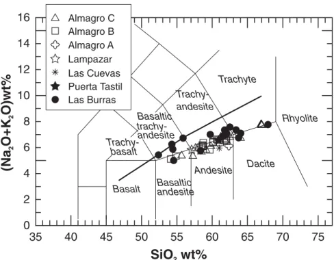
Almagro Volcanic Rocks
The Almagro rocks are subalkaline (Fig. 8); their SiO2 content ranges from 53 to 66 wt%,
defi ning a calc-alkaline trend from basaltic andesite to dacite (Fig. 8; Tables 4 and DR2 [see footnote 1]). Rocks of the Puerta Tastil, Las Cuevas, Lampazar, and Almagro A and B mem-bers are porphyritic andesites, with plagioclase and amphibole phenocrysts, some reaching up to 1–2 cm in size. In some lavas (Lampazar, Almagro A and B), clinopyroxene is the domi-nant mafi c phenocryst instead of amphibole. Silicic rocks occur in the Almagro C mem-ber and have a vitrophyric texture with sparse microcrystals of plagioclase, amphibole, and rare orthopyroxene. Apatite and Fe-Ti oxides are common accessories. Average phenocryst modal data are shown in Figure 9, and represen-tative analyses are provided in Table DR3 (see footnote 1). The Almagro C member rocks com-monly include xenoliths with quartz or garnet, eroded from the basement rocks during magma ascent or storage. No rocks with a mineral assemblage like that of the Las Burras intrusion were found.
Several disequilibrium features occur in the Almagro volcanic rocks. Some andesite lavas of the Puerta Tastil and Almagro B members con-tain magmatic enclaves of mafi c magma bear-ing olivine and clinopyroxene phenocrysts in an isotropic groundmass. They show a quench texture of the microlites, which suggests magma mingling processes (Bacon, 1986; Snyder, 2000; Perugini and Poli, 2000). In addition, most andesites of the Almagro B member con-tain phenocrysts of clinopyroxene coexisting with two populations of amphibole, one show-ing reaction rims (indicatshow-ing disequilibrium) and the other in equilibrium. This suggests the occurrence of mingling and mixing processes between magmas with anhydrous and hydrous paragenesis (Coombs et al., 2003; Coombs and Gardner, 2004, and references therein).
Basaltic andesites occur only in the Almagro B member. They are characterized by a banded texture, with dark microlite-rich bands alternat-ing with light-colored glassy portions. In the dark bands the prevalent phenocrysts are Cr-rich clinopyroxene with high Mg# (100*MgO/ [MgO + FeOt], where FeOt = total Fe as FeO) and sieve-textured plagioclase, whereas the light-colored bands have microcrystals of pla-gioclase without sieve texture, orthopyroxene, low Mg# clinopyroxene, Fe-Ti oxides, and apatite. A particularly primitive association of coarse olivine (Fo 87–83) with iddingsite rims, with small grains of Al- and Ti-rich clinopy-roxene averaging Wo47Fs10 and Cr-spinel (Cr# = 59–51), occurs in the dark bands (Table DR3; see footnote 1). Crystals from the dark bands occur in the clear ones and vice versa, and reverse or oscillatory zoning is common in the plagioclase, clinopyroxene, and orthopyroxene
phenocrysts (e.g., up to Mg# 66 in the core to 84 at the rim in clinopyroxene; Table DR3; Fig. DR1; see footnote 1). The basaltic andes-ites contain clinopyroxenitic enclaves 1–3 cm in size, with clinopyroxene composition in the range Wo42Fs11-Wo44Fs13 and scarce orthopy-roxene En72Fs25-En74Fs21, with, in one case, phlogopite with Mg# 74–71 and Al-Fe spinel.
GEOCHEMISTRY Major and Trace Elements
Representative analyses of the Las Burras– Almagro–El Toro complex rocks are presented in Table 4. The complete set of analyses is provided in Table DR1 (see footnote 1), and Harker-type diagrams are shown in Figure DR2 (see footnote 1). The Las Burras and Puerta Tastil rocks show the same geochemical char-acteristics, whereas the Almagro volcanic rocks younger than 11 Ma (Las Cuevas, Lampazar, and Almagro A, B, and C members) defi ne a distinct trend. The Las Burras and Puerta Tas-til rocks have higher K2O and lower MgO con-tents than the younger Almagro units. Al2O3 and Na2O exhibit a positive correlation with SiO2 for the Almagro rocks, whereas the Las Burras rocks show a bell-shaped pattern. CaO and TiO2 show a compatible behavior and decrease with silica. The two groups of rocks display distinct trends, with increasing silica in many trace ele-ment diagrams (Fig. DR2; see footnote 1): the Las Burras and Puerta Tastil members have a higher Rb content, a lower and constant Ba, and a similar and scattered Sr, when compared with the Almagro younger members. Nb shows a compatible behavior in the Las Burras and Puerta Tastil rocks, and an opposite trend in younger rocks. The most silicic products are the Almagro C dacite rocks, which show remark-ably high Zr and Hf contents.
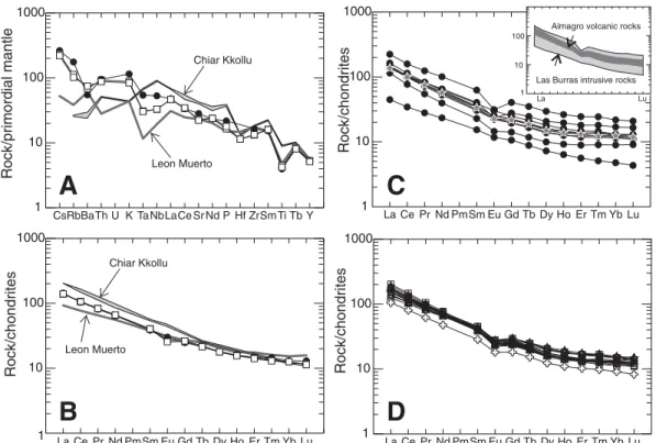
The most mafi c samples of the Las Bur-ras rocks have Mg# no higher than 63 and low Ni, Co, and Cr contents. The most primitive Almagro volcanic rocks are the basaltic andes-ites in the Almagro B member, with Mg# = 71–75. The spider diagrams in Figure 10A illus-trate the trace element composition of the most mafi c samples of the complex, and are compared with other arc (Leon Muerto, Fig. 1A; Trumbull et al., 1999) and intraplate Central Andes basalts (Chiar Kkollu, Fig. 1A; Davidson and de Silva, 1995). In the spider diagrams the Las Burras and Almagro B mafi c samples are approxi-mately similar, displaying positive anomalies of Rb, Th, K, and Pb, and negative troughs of Nb, Ta, and Ti. The Las Burras intrusive rocks show higher peaks of Rb, Th, and K, and very slight Nb and Ta troughs. The rare earth element 1GSA Data Repository Item 2008123, major and
trace element bulk rock analyses and mineral chem-istry of Las Burras intrusive rocks and of Las Burras-Almagro-El Toro volcanic rocks (data and selected diagrams), is available at www.geosociety.org/pubs/ ft2008.htm. Requests may also be sent to editing@ geosociety.org.
(REE) patterns of the mafi c samples of the Las Burras and Almagro B members are strikingly similar, except for a minor negative Eu anomaly in the latter (Fig. 10B). The Las Burras rocks show a wider range of REE abundances than the Almagro rocks younger than 11 Ma (Figs. 10C and 10D, and inset in C) and an increase of REE fractionation with silica (La/Yb from 12 to 18 for SiO2 from 52 to 65 wt%; Table DR1; see foot-note 1). A negative Eu anomaly characterizes all
the Almagro rocks, and only the most evolved Las Burras sample (Figs. 10C and 10D).
Sr and Nd Isotopic Ratios
In the 87Sr/86Sr versus 143Nd/144Nd diagram
(Fig. 11A) the Las Burras and Puerta Tastil rocks show the lowest Sr and the highest Nd isotopic ratios and defi ne a negative trend. In detail, the three samples from the southern
out-crops of Las Burras (feeder zone) defi ne a clus-ter with relatively low Nd and high Sr isotopic ratios (87Sr/86Sr ~0.7053; 143Nd/144Nd ~0.51259).
They are distinct from the samples from the central-northern outcrops, which have 87Sr/86Sr
~0.7045 and 143Nd/144Nd ~0.51271 (see inset in
Fig. 11A). The Almagro volcanic rocks younger than 11 Ma are separated from the Las Burras and Puerta Tastil rocks by a large gap in isoto-pic ratios, and their 87Sr/86Sr ratios range from
TABLE 4. MAJOR AND TRACE ELEMENT ANALYSES OF REPRESENTATIVE SAMPLES OF LAS BURRAS INTRUSIVE ROCKS AND ALMAGRO VOLCANIC ROCKS
Sample M-2 A-37 TA-104 TS302 TS 217 TS 11 TS 14 TS 18 N-32 TA-403 TA-210 TA-111
Member Las Burras Las Burras Las Burras Las Burras Puerta Tastil Las Cuevas Lampazar Almagro A Almagro B Almagro B Almagro C Almagro C Latitude S 24°18'55'' 24°20'30'' 24°21'19'' 24°19'56'' 24°31'18'' 24°29'33'' 24°32'54'' 24°32'50'' 24°24'27'' 24°22' 51'' 24°18'17'' 24°21'15'' Longitude W 65°52'20'' 65°52'37'' 65°53'52'' 65°51' 36'' 65°45'58'' 65°53'30'' 65°50'47'' 65°50'31'' 65°52'29'' 65°51' 32'' 65°53'07'' 65°52'06'' SiO2 (wt%) 61.75 55.13 64.94 61.08 60.47 59.84 56.47 61.36 53.17 61.84 55.02 61.15 TiO2 0.69 1.01 0.41 0.66 0.76 0.78 1.04 0.67 1.14 0.76 1.28 0.60 Al2O3 16.69 16.83 14.06 16.46 15.30 16.85 17.11 16.05 15.02 16.62 15.80 17.72 Fe2O3tot. 6.18 8.11 3.91 5.63 6.79 6.17 7.47 5.35 9.24 5.83 9.60 4.68 MnO 0.16 0.17 0.07 0.15 0.12 0.12 0.15 0.12 0.14 0.11 0.15 0.09 MgO 2.07 3.07 1.07 1.69 1.93 2.77 3.66 2.62 5.99 2.67 4.71 1.15 CaO 5.57 7.18 3.24 5.35 7.03 5.32 6.81 5.87 8.01 5.02 6.57 4.38 Na2O 3.19 3.24 2.69 3.56 3.12 3.31 3.00 3.70 2.57 2.93 2.66 3.29 K2O 3.70 3.49 5.08 3.53 3.45 2.65 2.82 2.43 2.55 3.69 2.70 3.64 P2O5 0.32 0.45 0.17 0.31 0.34 0.29 0.36 0.23 0.37 0.31 0.36 0.33 L.O.I. 0.35 0.37 0.46 0.44 1.41 1.92 1.23 1.09 1.39 1.61 0.28 0.94 Be (ppm) 2.29 2.72 3.50 2.47 2.17 2.40 2.23 1.85 1.74 2.85 1.67 2.95 Sc 10 13 6 8 12 14 22 15 23 12 24 7 V 104 168 70 90 95 120 198 123 222 108 225 42 Cr 12 26 10 9 85 34 27 114 309 50 52 5 Co 13 19 5 11 15 15 20 17 60 13 29 6 Ni 8 14 4 7 25 15 13 24 58 15 32 3 Cu 22 26 35 17 27 18 30 14 37 21 50 8 Rb 162 151 192 167 142 134 102 88 88 138 91 145 Sr 550 650 378 639 524 469 575 547 530 543 429 550 Y 25.0 26.2 16.1 23.6 22.9 24.7 29.4 17.9 25.8 22.9 30.4 24.6 Zr 162 179 114 - 77 187 182 102 147 193 169 371 Nb 31.6 32.9 23.7 36.9 29.9 19.6 22.6 13.2 20.5 24.0 19.4 23.9 Cs 7.78 5.00 3.50 4.25 4.57 6.27 4.28 2.15 4.18 8.10 3.24 7.00 Ba 418 415 341 471 380 507 573 454 565 624 425 999 La 34.5 34.0 27.2 38.7 32.4 36.8 35.7 24.9 33.1 42.0 29.3 42.0 Ce 63.5 64.0 47.0 69.8 61.3 70.9 69.2 49.2 64.5 78.0 61.0 79.0 Pr 7.3 7.7 5.2 7.9 7.1 8.3 8.1 5.9 7.9 9.1 7.5 9.2 Nd 27.7 30.1 18.5 29.0 26.6 30.4 30.9 22.2 30.9 34.0 30.0 34.0 Sm 5.3 5.9 3.5 5.4 5.1 5.9 6.0 4.4 6.2 6.2 6.5 6.0 Eu 1.45 1.75 0.84 1.43 1.31 1.28 1.39 1.05 1.57 1.47 1.59 1.37 Gd 4.6 5.1 2.9 4.7 4.5 5.0 5.7 3.8 5.4 5.0 6.1 4.8 Tb 0.72 0.80 0.44 0.69 0.70 0.77 0.85 0.57 0.83 0.76 0.95 0.72 Dy 4.1 4.6 2.5 4.0 3.8 4.3 5.0 3.1 4.5 4.1 5.5 4.1 Ho 0.83 0.90 0.52 0.81 0.78 0.83 0.99 0.62 0.89 0.80 1.09 0.82 Er 2.27 2.44 1.47 2.23 2.18 2.29 2.76 1.69 2.39 2.12 2.89 2.25 Tm 0.35 0.37 0.23 0.35 0.31 0.35 0.42 0.25 0.34 0.30 0.43 0.37 Yb 2.22 2.22 1.52 2.10 2.10 2.20 2.60 1.55 2.14 1.93 2.65 2.27 Lu 0.32 0.33 0.23 0.31 0.30 0.31 0.37 0.21 0.29 0.28 0.38 0.36 Hf n.d. n.d. n.d. n.d. 2.32 4.86 4.59 2.99 3.99 5.20 4.49 8.40 Ta 2.50 2.33 1.95 2.76 2.26 1.46 1.44 0.92 1.30 1.67 1.21 1.58 Tl 0.95 0.88 0.92 0.99 0.11 0.70 0.61 0.25 0.33 0.96 0.56 0.88 Pb n.d. 9.1 N.D. 9.9 14.1 11.2 7.7 12.7 16.2 n.d. 14.3 Th 12.79 9.10 19.40 13.03 11.22 12.05 9.21 6.40 8.41 12.80 7.39 11.60 U 3.29 2.51 3.31 2.69 2.36 2.69 2.34 1.76 1.88 3.06 1.71 2.83 87 Sr/86 Srmeas .(±2s) 0.70486 (10) 0.704688 (10) 0.70559 (11) 0.704936 (11) 0.705233 (12) 0.708509 (11) n.d n.d. 0.706788 (11) 0.707683 (12) 0.707965 (10) 0.708419 (12) 87 Rb/86 Sr 0.861 0.692 1.513 0.755 0.715 0.826 n.d. n.d. 0.479 0.758 0.614 0.775 87 Sr/86 Srt 0.704685 0.704547 0.705281 0.704782 0.705103 0.708380 n.d. n.d. 0.706738 0.707604 0.707904 0.708345 143 Nd/144 Ndmeas .(±2s) 0.51271 (9) 0.512696 (5) 0.512609 (6) 0.512693 (9) 0.512646 (10) 0.512374 (11) n.d. n.d. 0.512439 (11) 0.51242 (11) 0.512425 (12) 0.512389 (7) 147 Sm/144Nd 0.116 0.119 0.113 0.112 0.117 0.118 n.d. n.d. 0.121 0.119 0.131 0.109 143 Nd/144Ndt 0.51 699 2 0.51 685 2 0.51 598 2 0.51 682 2 0.51 636 2 0.51 366 2 n. . d n. . d 0.51 433 2 0.51 292 2 0.51 419 2 0.51 384 2
Note: Analytical methods in Appendix. Trace elements analyzed by ICP-MS except Zr for Las Burras intrusive rocks. The complete set o f analyses is available as
0.706738 to 0.708729 and 143Nd/144Nd ratios
from 0.512433 to 0.512360; the basaltic andes-ites of the Almagro B member show the low-est Sr and highlow-est Nd ratios. In Figure 11B the isotopic ratios are plotted against SiO2 contents. The Las Burras samples show a very weak posi-tive correlation between silica and Sr isotopic ratios and a negative correlation between silica and Nd. Overall, the Almagro volcanic rocks do not indicate any correlation of isotopic ratios with SiO2 content, although patterns can be observed within the samples from individual volcanic members.
DISCUSSION Geological Evolution
Las Burras Intrusion
The Las Burras intrusion is the oldest Ceno-zoic magmatic unit in the study area. Its foliation, subparallel to the magma fl ow, is interpreted as the mechanical expression of a discontinuity in the fl ow (Marre, 1986; Paterson and Vermon, 1995; Hrouda et al., 1999; Dietl and Koyi, 2002). Therefore, the strike and dip of the foliation indicate the fl ow directions of magma within the pluton (Ferré et al., 2002). The foliation, subpar-allel to the contact with the overlying host rock, suggests lateral fl ow of magma at the top of the intrusion. The subvertical and NE-SW–trending foliation in the center of the southernmost part suggests vertical fl ow (Figs. 3 and 6A). These fl ow directions, together with the tabular intru-sion shape, thicker in the center, suggest that the Las Burras intrusion is a laccolith, elongated NE-SW, with a NE-SW–trending feeder dike in its southern part. The differences in Sr and Nd isotopic composition between the feeder zone (southern outcrop) and the main intrusive body (central-northern outcrop; see inset in Fig. 11A) could relate to distinct batches of magma feed-ing the laccolith. The voluminous fi rst batches had higher Nd and lower Sr isotopic ratios than the later ones, representing a new, slightly more evolved and contaminated pulse of magma that formed the feeder zone.
The emplacement of the NE-SW–trending feeder dike at the base of the laccolith could be kinematically related to the N-S–striking dextral faults. These faults were likely active in the Mio-cene (see the Structural Features section) during pluton emplacement. The N-S–striking dextral faults at the NE and SW sides of the intrusion could have created a releasing bend, or a local-ized extensional zone, which favored the rise of magma through one or more NE-SW–trending feeder dikes (cf. Busby-Spera and Saleeby, 1990; Glazner, 1991; Tikoff and Teyssier, 1992; Tobisch and Cruden, 1995; Tikoff and de Saint
35
40
45
50
55
60
65
70
75
0
2
4
6
8
10
12
14
16
Basalt Basalticandesite
Andesite Dacite Rhyolite Trachyte Trachy-andesite
SiO wt%
2(Na
O+K
O)wt%
2 2 Basaltic trachy-andesite Trachy-basalt Las Burras Puerta Tastil Las Cuevas Lampazar Almagro A Almagro B Almagro C cpx cpxPuerta Tastil hbl 60 vol%
qz andesite monzogranite Almagro A andesite basaltic andesite cpx cpx ol ol ol ol ol Lampazar <10 to <5 vol% hbl 40-50 vol% 40-50 vol% 35-40 vol% cpx opx 50-60 vol% 60 vol% pl pl pl pl pl pl pl hbl hbl Las Cuevas 45-55 vol% andesite andesite andesite Almagro B Almagro C PHENOCRYST CONTENT MODAL COMPOSITION andesite dacite monzodiorite monzogabbro Las Burras hbl hbl pl pl pl ox ox ox ox ox ox ox ox hbl+bt cpx cpx ol+ox ol+ox hbl pl hbl
few crystals of pl, hbl and opx opx opx cpx af af af
Figure 8. TAS (total alkali versus SiO2 wt%) diagram (Le Bas et al., 1986) of Las Burras–Almagro–El Toro rocks. Heavy line (Irvine and Baragar, 1981) divides alka-line and subalkaalka-line fi elds.
Figure 9. Mineral phase content (volume percentages) of representative samples of the Las Burras intrusion and the Almagro volcanic rocks: pl—plagioclase; af—alkali feldspar; qz—quartz; hbl—hornblende; cpx—clinopyroxene; opx—orthopyroxene; ol—olivine; bt— biotite; ox—Fe-Ti oxides.
0.702 0.704 0.704 0.705 0.706 0.708 0.710 0.712 0.714 0.716 0.5119 0.5121 0.5123 0.5125 0.5127 0.5129 0.5131 87 86 Sr/ Sr CK LM Crustal Puna ignimbrites To crustal basement of the study area Enriched
lithospheric mantle
Calama-Olacapato-El Toro Miocene volcanics
44 46 48 50 52 54 56 58 60 62 64 66 68 70 72 0.5121 0.5122 0.5123 0.5124 0.5125 0.5126 0.5127 0.5128 0.704 0.706 0.708 0.710 0.712 0.714 0.716 0.718 SiO wt%2 87 86 Sr/ Sr 143 144 Nd/ Nd CK LM Crustal Puna ignimbrites LM CK Crustal Puna ignimbrites
A
DepletedB
lithospheric mantle Calama-Olacapato-El Toro Miocene volcanics Calama-Olacapato-El Toro Miocene volcanics 0.5128 0.5126 CK LM 143 144 Nd/ Nd Southern sector Northern sectorFigure 11. Sr versus Nd isotope ratio diagrams (A) and Sr and Nd isotope ratios versus silica (B). Symbols are as in Figure 8; open fi eld: Calama–Olacapato–El Toro vol-canic rocks from Matteini et al. (2002a, b) and Petrinovic et al. (2005). Dashed fi elds: lithospheric mantle domains from Lucassen et al. (2002, 2005); gray fi eld: Puna crustal ignimbrites from Ort et al. (1996) and Francis et al. (1989). CK—Chiar Kkollu basalt, Davidson and de Silva (1995); LM—Leon Muerto basalt, Trumbull et al. (1999). Inset in A shows the isotopic difference between the northern and southern sectors of the Las Burras intrusion.
1 10 100 1000 CsRbBaTh U K TaNbLaCe Sr Nd P Hf ZrSm Ti Tb Y Chiar Kkollu Leon Muerto
A
B
Chiar Kkollu Leon Muerto 10 100 1000 Rock/chondrites Rock/primordial mantle Rock/chondrites Rock/chondrites La Ce Pr Nd PmSm Eu Gd Tb Dy Ho Er Tm Yb Lu 1C
1 10 100 1000 La Ce Pr Nd PmSm Eu Gd Tb Dy Ho Er Tm Yb LuD
1 10 100 1000 La Ce Pr Nd PmSm Eu Gd Tb Dy Ho Er Tm Yb Lu 1 10 100 La LuAlmagro volcanic rocks
Las Burras intrusive rocks
Figure 10. (A) Spider diagrams (normalized relative to primor-dial mantle after Wood et al., 1979) for the mafi c Las Burras and Almagro rocks. Symbols are as in Figure 8. (B) Rare earth element (REE) patterns (normalized relative to chon-drite, after McDonough and Sun, 1995) for the mafi c Las Burras and Almagro rocks. The Chiar Kkollu and Leon Muerto basalts (Davidson and de Silva, 1995; Trumbull et al., 1999) are shown in A and B for comparison. (C, D) Chondrite-normalized REE patterns for Las Burras and Almagro rocks (normalized as in Fig. 10B). In the inset in Figure 10C the ranges in REE abundance for Las Burras and Almagro are compared.
Blanquat, 1997; de Saint Blanquat et al., 1998). The magma would have been initially emplaced as a sill, developing into a laccolith as a result of prolonged injection. The uplift of the overburden, now partly eroded, accommodated the emplace-ment. The widespread strike-slip tectonics in the area are here interpreted as having been due to a local deviation in the pattern of overall ~E-W convergence (Cladouhos et al., 1994; Marrett et al., 1994; Marrett and Strecker, 2000; Acocella et al., 2007), which controlled the development of the thrust zones at the margins of the El Toro basin (Marrett et al., 1994; Marrett and Strecker, 2000, and references therein).
Almagro Volcanic Rocks
The Almagro volcanic units consist of sev-eral lava domes, lava fl ows, and scoria cones, related to monogenetic centers in a limited area (Fig. 12). Stratigraphic and geochronological data indicate that this volcanism occurred dur-ing ca. 13–6 Ma. Between ca. 13 Ma (the Puerta Tastil member) and 11 Ma (the Las Cuevas mem-ber) volcanism was lacking, whereas between ca. 8–6 Ma (the Lampazar and Almagro A, B, and C members) volcanism peaked in terms of frequency of eruptions, number of eruptive cen-ters, volume of discharged magma, and spatial distribution of the products. After ca. 6 Ma, vol-canism ceased in this part of the Eastern Cor-dillera. The Almagro volcanic activity produced small volumes of magma, and contrasts with the volcanism of the Calama–Olacapato–El Toro
fault zone in the central-western Puna Plateau, where large stratovolcanoes were emplaced and large volumes of ignimbrites were erupted (Mat-teini et al., 2002b; Petrinovic et al., 2005).
The main directions of the feeder dikes are ~W-E, ~N-S, and ~WNW-ESE (Figs. 3 and 7). The dikes (1) are parallel or subparallel to the main N-S and NW-SE fault systems and (2) indicate extension along these trends, consistent with the structural data. Therefore, the volca-nic activity with a peak at 8–6 Ma was prob-ably related to the extensional episode along the Calama–Olacapato–El Toro fault zone.
El Toro Basin
The volcanic members interlayered with the Tertiary sediments of the El Toro basin help put stratigraphic and geochronological constraints on basin evolution during 11–6 Ma and its rela-tionship with the Las Burras–Almagro Range (Fig. 12).
The amount and timing of uplift of the two N-S–trending ranges bordering the El Toro basin (the Las Burras–Almagro Range and the Sierra Pascha; Fig. 2) are quite different. The following stratigraphic, sedimentological, and structural evidence indicates that the Las Bur-ras–Almagro Range was uplifted, eroded, and unroofed during 11–7 Ma:
1. The Agujas conglomerate (Marrett and Strecker, 2000) in the quebrada el Chorro and in the eastern part of the quebrada Carachi (sections 6 and 7 in Fig. 5) is younger than ca. 13 Ma (the
Puerta Tastil member) and older than ca. 7 Ma (the Almagro A member). The clast composi-tion of this conglomerate comprises, in order of abundance, quartzite and sandstone (from the Cambrian Meson Group), red granite, gray granodiorite and green porphyry (from the Pre-cambrian Santa Rosa de Tastil batholith), and black siltstone (from the Puncoviscana Forma-tion). This composition, together with the paleo-fl ow direction reported by Hilley and Strecker (2005), suggests clast provenance from the Las Burras–Almagro Range.
2. The Las Cuevas member nonconformably overlies the Santa Rosa de Tastil batholith, sug-gesting that the southwesternmost part of the Las Burras–Almagro Range, which is close to the Calama–Olacapato–El Toro fault zone, was unroofed and exposed before ca. 11 Ma (Fig. 12).
3. The lower part of the Alfarcito conglom-erate (Marrett and Strecker, 2000), cropping out in the quebrada Carachi, is younger than ca. 8 Ma (the Lampazar member) and older than ca. 7 Ma (the Almagro A member). The clasts are black siltstone (from the Puncoviscana For-mation) and red granite (from the Precambrian Santa Rosa de Tastil batholith). This deposit thus records that at ca. 7 Ma the unroofi ng of the central Las Burras–Almagro Range reached the Puncoviscana cover.
4. In the Las Burras–Almagro Range the vol-canic rocks of the Almagro A, B, and C members overlie the Puncoviscana Formation (Figs. 3, 5,
NW - Almagro Range
El Toro basin - SE
PV P S BS BS AC AC Lampazar 7.87 Ma Las Cuevas 11.12 Ma Almagro B 7.4-7.0 Ma Almagro B 7.4-7.0 Ma Almagro A and B volcaniclastic deposits Almagro C 6.7–6.4 Ma ALC T LBP PV Las Burras 14.2 Ma 65 °53 ’ 65 °48’ 5 km m k 5 65 °5 8’W 24°29’ 24°3 6’ 24°22’ S Puerta Tastil 12.78 Ma
N
Figure 12. Schematic block diagram of the Las Burras–Almagro–El Toro region, illustrating the overall relation-ships between the Las Burras and Almagro magmatic activity and the evolution of the El Toro basin ca. 6 Ma (end of the Almagro volcanism). ALC—Alfarcito conglomerate; AC—Agujas conglomerate; BS—Barres sandstones; S—Salta Group; P—Paleozoic units; PV—Puncoviscana Formation; T—Santa Rosa de Tastil batholith.