Asynchronous, Distributed Optimization for the Coordinated Planning
of Air and Space Assets
By
Thomas Michael Herold
B.S. Operations Research
United States Air Force Academy, 2008
Submitted to the Sloan School of Management in Partial Fulfillment of the Requirements for the
Degree ofMASSACHUSETTS INSTITUTE
MASTER OF SCIENCE IN OPERATIONS RESEARCH
OF TECHNOLOGYat the
AUG
0
3 2010
MASSACHUSETTS INSTITUTE OF TECHNOLOGY
June2010
LIBRARIES
Copyright © 2010 Thomas M. Herold. All rights reserved.
ARCHIVES
The author hereby grants to MIT permission to reproduce and to distribute publicly paper and
electronic copies of this thesis document in whole or in part.
Si-ature
of Author:z1oan DCItuUi u1 ivia p:,LCL6 J m
Interdepartmental Program in Operations Research
14 May 2010A Thrnxcl~ear
1'T-Nvaric ADramson Charles Stark Draper Laboratory, Inc. echnical Supervisor Certified by: Hamsa -3alakrishnan Assistant Professor, Aeronautics and Astronautics Thesis Advisor Accepted by:
Dimitris
J.
Bertsimas
Boeing rofessor of Operations Research
Co-Director, Operations Research Center
Asynchronous, Distributed Optimization for the Coordinated Planning of Air and Space Assets
by
Thomas Michael Herold
Submitted to the Sloan School of Management
on May 14, 2010 in partial fulfillment of the requirements for the Degree Master of Science in Operations Research
ABSTRACT
Recent decades have seen the development of more advanced sensor and
communication systems, with the future certainly holding more innovation in these areas. However, current operations involve "stovepipe" systems in which inefficiencies are inherent. In this thesis, we examine how to increase the value of Earth observations made by coordinating across multiple collection systems. We consider both air and space assets in an asynchronous and distributed environment. We consider requests with time windows and priority levels, some of which require simultaneous observations by different sensors. We consider how these improvements could impact Earth observing sensors in two use areas; climate studies and intelligence collection operations. The primary contributions of this thesis include our approach to the asynchronous and distributed nature of the problem and the development of a value function to facilitate the coordination of the observations with multiple surveillance assets.
We embed a carefully constructed value function in a simple optimization problem that we prove can be solved as a Linear Programming (LP) problem. We solve the optimization problem repeatedly over time to intelligently allocate requests to single-mission planners, or "sub-planners." We then show that the value function performs as we intend through empirical and statistical analysis.
To test our methodologies, we integrate the coordination planner with two types of sub-planners, an Unmanned Aerial Vehicle (UAV) sub-planner, and a satellite sub-planner. We use the coordinator to generate observation plans for two notional operational Earth Science
scenarios. Specifically, we show that coordination offers improvements in the priority of the requests serviced, the quality of those observations, and the ability to take dual collections. We conclude that a coordinated planning framework provides clear benefits.
Technical Supervisor: Mark Abramson Title: Member of the Technical Staff The Charles Stark Draper Laboratory, Inc.
Thesis Advisor: Hamsa Balakrishnan Title: Assistant Professor
ACKNOWLEDGEMENTS
I would like to express my profound appreciation to all those who have helped me in
my endeavors for the past two years. First, I want to thank Mark Abramson and Dr. Stephan Kolitz of Draper Laboratory. Their commitment to not only my work but to my learning and development over the past two years has been something for which I am very thankful. I will undoubtedly be a more useful asset to the Air Force as a result of their guidance.
I would also like to thank Professor Hamsa Balakrishnan for taking me as her advisee
despite her already enormous workload. I am grateful to have had a person of such patience and intellect to work with, and who genuinely cared about my work and my growth as a student.
Next, I want to thank Alex Kahn and Dr. David Carter of Draper Laboratory for their help on this project. I thank Alex for all of his help on the myriad topics he helped me with over the past year. I will miss our baseball discussions as well. I thank David for his patience in teaching me the intricacies of astrodynamics and other new concepts.
I would like to thank the Air Force Academy, MIT, and The Charles Stark Draper
Laboratory for giving me this incredible opportunity to further my knowledge.
I must thank the great people and animals that have surrounded me these past few
years and shared my experiences. Jake and Chris, I sincerely thank you for your friendship and for helping me get through these times. You guys are the best there is, and will make some of the finest UAV pilots the Air Force has seen, although I hope that isn't the case. I also feel compelled to give a shout out to the P-Man for his undying and certainly unconditional love. Finally, Zeus, it has been an honor to have shared a home with you for two years.
I want to thank my family for their constant love and support. Mom, Dad, and Jim, I am so very thankful for everything you've done for me throughout my life, particularly this past year. I am the person I am today because of you.
Most importantly, I need to thank God for the gifts and opportunities He has given me so far in my life. Sic transit gloria mundi.
The views expressed in this thesis are those of the author and do not reflect the official policy or position of the United States Air Force, Department of Defense, or The U.S.
Government.
This thesis was prepared at The Charles Stark Draper Laboratory, Inc. under Internal Company Sponsored Research Projects 22917-001 and 23935-001, Collection Management Optimization and Collection Management Optimization 2.
Publication of this thesis does not constitute approval by Draper or the sponsoring agency of the findings or conclusions contained therein. It is published for the exchange and stimulation of ideas.
Table of Contents
LIST O F FIG URES...
11
LIST O F TABLES ...
13
1
IN TRO D UCTIO N ...
15
1.1 Thesis Overview...16
1.2 Contributions...17
1.3 Thesis M otivation ... 18
2
EARTH-OBSERVING SYSTEM COORDINATION PLANNER
O PERATIO N AL CO N CEPT ...
21
2.1 Earth-Observing Sensors ... 22
2.1.1 Earth-Observing Sensors and Climatology ... 22
2.1.2 Earth-Observing Sensors and Intelligence, Surveillance, and Reconnaissance in a B attlesp ace ... 27
2.1.3 Current Operations Framework ... 29
2.1.4 Future Operations Framework ... 36
2.2 The Coordination Planner within Larger Frameworks... 37
2.2.1 Collection M anagement Process... 37
2.2.2 The Coordination Planner within a W eb Service ... 37
2.2.3 The Coordination Planner within a Sensor W eb ... 38
2.3 Real-W orld Scenarios...40
2.3.1 CLARREO Scenario ... 40
2.3.2 W RAP Scenario ... 41
2.4 Earth Phenomena Observation System (EPOS) ... 42
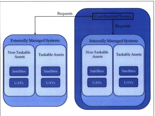
2.4.1 EPOS Functional Overview ... 42 7
2.4.2 Role of the C oordination Planner ... 43
2.5 C oordination Planner Problem ... 44
3
MODEL CONTEXT AND DEVELOPMENT ...
47
3.1 Problem Scope ... 47
3.1.1 K ey Term inology ... 48
3.1.2 Term inology in CLA RREO C ontext ... ... ... 58
3.2 M odeling A ssum ptions...59
3.2.1 Stochastic N ature of the Real-W orld Problem ... 59
3.2.2 Sim ulation of the Real-W orld Problem ... 59
3.2.3 C om plete Know ledge of Planning Cycles... 60
3.2.4 A strodynam ics M odeling ... 60
3.2.5 D ual C ollects...63
3.2.6 C ontinuous Tim e and Space... 64
3.2.7 Q uality of O bservations...66
3.3 Coordination Planner M odel O verview ... 67
3.3.1 C oordination Planner ... 68
3.4 Existing Functional Pieces...71
3.4.1 U A V Sub-Planners...72
3.4.2 Satellite Sub-Planners...73
4
ALGORITHMIC APPROACHES...75
4.1 Literature R eview ... 75
4.1.1 Space-Based Earth-O bservation M ission Planning ... 76
4.1.2 U A V M ission Planning ... 81
4.1.3 D yna m ic M odels ... 82
4.1.4 C oordinated Planning ... 84
4.1.5 A ssignm ent Problem s ... 87
4.2 Coordination Planner Functional A rchitecture ... 90
4.3 V alue Function Construction ... 92
4.3.1 Convex Combination of Value Function Components... 92
4.3.2 N otation and D efinitions ... 92
4.3.3 V alue Function C om ponents... 97
4.4 A ssignm ent Problem Construction...109
4.4.1 Static Form ulation...110
4.4.2 D ynam ic V alue U pdating ... 113
4.4.3 Plan Com parisons...115
4.5 Implementation of Iterative Assignment Problem Formulation ... 117
4.5.1 Softw are A rchitecture...117
4.5.2 Sam ple Input D ata ... 120
4.5.3 Test Set D evelopm ent...121
4.5.4 O utput ... 122
5 RESULTS AND ANALYSIS ... 125
5.1 V alue Function Testing... ... 125
5.1.1 Em pirical A nalysis...126
5.1.2 Statistical A nalysis ... 128
5.2 O bjective Function Tuning ... ... 141
5.2.1 N on-Linear Form ulations ... 141
5.2.2 Robust O ptim ization (RO ) A pproaches...144
5.3 Sub-Planner Q uery Flexibility...146
5.4 R ejecte d
Q
ueries ... ... 1495.5 Coordination Planner versus Baseline Scenarios...150
5.6 CLA R REO O rbit A nalysis...154
5.6.1 V arying Inclinations ... 156
5.6.3 Dual Collect Inter-Observation Times ... 157
5.7 Dual Collection Scenario...159
5.8 W RAP Scenario Analysis...160
6
CONCLUSIONS AND FUTURE WORK...163
6.1
Summary of Contributions ...
163
6.2 Future 6.2.1 6.2.2 6.2.3 6.2.4 6.2.5 6.2.6W ork ...
165
O pportunities for H um an Interaction...165
A dding Fidelity to the Coordination Planner ... 166
Statistical Studies of Real-W orld Planners ... 169
Tim e-D elay A nalysis ... 170
A uction A lgorithm s...170
Call-Center Routing...171
6.3 C onclusions...171
APPENDIX A
-
LIST OF ACRONYMS...173
APPENDIX B
-
TARGET-TO-SENSOR VALUE LOOKUP TABLE...177
APPENDIX C
-
PLANNING CYCLES CALCULATIONS ...
179
APPENDIX D
-
TOTAL UNIMODULARITY PROOF ...
181
APPENDIX E
-
REGRESSION OUTPUT ...
185
APPENDIX F
-
PAIRED T-TESTS...187
LIST OF FIGURES
FIGURE 2-1: FOREST FIRE SIZES OVER TIME [6]...25
FIGURE 2-2: AIRS IMAGE OF VOLCANIC ASH, [14]... 27
FIGURE 2-3: JOINT TARGETING CYCLE [15]...28
FIGURE 2-4: SATELLITES OF THE "A-TRAIN" [19] ... 31
FIGURE 2-5: SIMULTANEOUS NADIR OVERPASSES (SNOS) AND SIMULTANEOUS CONICAL OVERPASSES (SCOS)...33
FIGURE 2-6: ASYNCHRONOUS PLANNING CYCLES... 35
FIGURE 2-7: CURRENT USER INTERACTION WITH "STOVEPIPE" SYSTEMS. ADAPTED FROM [24]. ... 3 6 FIGURE 2-8: FUTURE FRAMEWORK OF CENTRALIZED SYSTEM ... 37
FIGURE 2-9: SENSOR WEB DIAGRAM [26]...39
FIGURE 2-10: PROPOSED CLARREO ORBITS [27]... 41
FIGURE 2-11: EPOS STRUCTURE [30] ... 43
FIGURE 3-1: USING POINT TARGETS TO DEFINE AREAS OF INTEREST ... 50
FIGURE 3-2: PLANNING SYSTEMS...53
FIGURE 3-3: RELATIONSHIP BETWEEN PLANNING PHASES AND EXECUTION PHASES ... 55
FIGURE 3-4: DEFINING PLANNING PERIODS ... 57
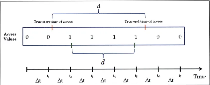
FIGURE 3-5: DEPICTION OF ROUNDING HEURISTIC FOR COMPUTING SATELLITE-TO-TARGET A C C E SSE S ... 65
FIGURE 4-1: COORDINATION IN A HIERARCHICAL, DECENTRALIZED SCENARIO. ADAPTED F R O M [24]...89
FIGURE 4-2: FUNCTIONAL ARCHITECTURE ... 91
FIGURE 4-3: PLANNING PERIOD EXAMPLE ... 95
FIGURE 4-4: ASSIGNMENTS AT A SINGLE ITERATION...112
FIGURE 4-5: ASSIGNMENT EXAMPLE. ADAPTED FROM [63]...113
FIGURE 4-6: SOFTWARE ARCHITECTURE ... ... 118
FIGURE 4-7: ALGORITHMIC FLOW ... 119
FIGURE 4-8: SAMPLE REQUEST DATA...120
FIGURE 4-9: SUB-PLANNER DATA...121
FIGURE 4-10: SAMPLE OUTPUT...122
FIGURE 5-1: VARYING THE PRIORITY INPUT WEIGHT ... 126
FIGURE 5-2: VARYING THE DUAL COLLECTION INPUT WEIGHT...127 11
FIGURE 5-3: VARYING THE TARGET-TO-SENSOR VALUE INPUT WEIGHT...128
FIGURE 5-4: REGRESSION MODEL INPUTS/OUTPUTS...133
FIG U RE 5-5: A C TU A L M O D EL ... 134
FIGURE 5-6: VARYING COMMUNICATION CONSTRAINTS...147
FIGURE 5-7: PERCENT INCREASE IN TOTAL PRIORITY DUE TO FEEDBACK ... 148
FIGURE 5-8: SIMULATION ENVIRONMENT CASES ... 151
FIGURE 5-9: SIMULATION ENVIRONMENT TEST RESULTS ... 153
FIGURE 5-10: DISTRIBUTION OF THE TIME BETWEEN DUAL COLLECTS...158
FIGURE 5-11: DUAL COLLECTION INTER-OBSERVATION TIMES...160
FIGURE 5-12: WRAP SCENARIO TARGET LOCATIONS...161
LIST OF TABLES
TABLE 2-1: INTELLIGENCE COLLECTION DISCIPLINES [16]... 29
TABLE 2-2: SATELLITE MISSION DEFINITIONS [13]...30
TABLE 3-1: REQUEST ATTRIBUTES...49
TABLE 3-2: KEPLER ELEMENTS [33]...61
T A B L E 4-1: SE T S...93
TABLE 4-2: REQUEST DATA...93
TABLE 4-3: PLANNER DATA ... 94
TABLE 4-4: SYSTEM DATA...95
TABLE 4-5: SENSOR DATA ... 96
TABLE 4-6: UAV SUB-PLANNER DATA ... 96
TABLE 4-7: SATELLITE SUB-PLANNER DATA ... 97
TABLE 4-8: VALUE FUNCTION SUMMARY ... 109
TABLE 4-9: DYNAMIC VALUE UPDATE DECISIONS...115
TABLE 4-10: PAIRING INPUT WEIGHTS WITH MOPS...116
TABLE 4-11: ALGORITHMIC FUNCTIONS BY SECTION ... 119
TABLE 5-1: TRAINING SET REGRESSION RESULTS...135
TABLE 5-2: TEST SET REGRESSION RESULTS...136
TABLE 5-3: RELATIONSHIPS FOUND BETWEEN VARIABLES THROUGH REGRESSION ... 137
TABLE 5-4: SUMMARY OF REGRESSION MODEL PERFORMANCE...140
TABLE 5-5: RESULTS FROM EXAMPLES OF WEIGHT VECTOR OPTIMIZATION ... 143
TABLE 5-6: ACTUAL VERSUS PREDICTED MOPS... ... ... 144
TABLE 5-7: EFFECTS OF RANDOM VALUE INCREASES...150
TABLE 5-8: CLARREO SCENARIO ORBIT ANALYSIS CASES ... 155
1 Introduction
The development of advanced sensor and communication systems has allowed for vastly improved Earth observation systems. Air- and space-based sensors can observe the Earth from a vantage unmatched by multiple ground-based sensors, and as the capabilities of new sensor systems increase, so does our ability to monitor Earth-based phenomena. However, current operations are hindered by the "stovepiped" nature of individual mission systems that limit the amount of coordination that exists amongst various remote-sensing platforms. We refer to this absence as the Coordination Planner Problem (CPP).
The purpose of this thesis is to examine this problem and develop an algorithm and the associated software to coordinate the planning of air- and space-based observation missions in a realistic environment. The algorithm developed addresses four primary challenges presented in the CPP. The first challenge is creating plans in an asynchronous environment, in which
individual mission planners operate on different planning cycles. The second challenge results from the distributed nature of the problem in which individual mission planners operate independently of each other and are not entirely subservient to the coordination planner. The
third challenge is to create an algorithm that can coordinate the observation of a single location with multiple assets, for example, an air- and a space-based sensor, called a dual collection. The fourth and final challenge deals with creating plans for both air- and space-based sensor assets.
This chapter introduces the various sections of this thesis. The first section gives a brief description of each of the chapters of this thesis. The second section highlights the main contributions of this thesis to the coordinated planning literature. The third section motivates this work and states the goals of this thesis.
1.1 Thesis Overview
This thesis discusses the CPP in six chapters. An overview of each of the remaining five chapters is given in the following paragraphs:
Chapter 2 describes the operational concept for the coordination planner in the context
of real-world scenarios. This chapter explains the coordination planner's functional purpose in the context of Draper Laboratory's Earth Phenomena Observation System (EPOS). Most importantly, this chapter describes current operations and the inefficiencies they present. We use the chapter to explain how the coordination planner must operate in an asynchronous environment, as well as how it can be used in the larger context of a collection management process. Then, we outline real-world scenarios to which we can apply the results of this thesis. We introduce two scenarios whose objectives include monitoring Earth phenomena across multiple platforms. Specifically, we describe the Climate Absolute Radiance and Refractivity Observatory (CLARREO) mission and possible applications of coordinated planning within the context of the Wildfire Research and Applications Partnership (WRAP) program.
Chapter 3 explains the development of our model for the CPP. We first define
terminology that helps the reader to understand the multiple facets of the CPP and to
understand the scope of our model. This chapter also states the key assumptions made for our model, and provides an overview of the inputs, decisions, objectives, and constraints that we model for the CPP. Then, we give a description of the requirements of existing functional planning algorithms for the CPP's sub-planners.
Chapter 4 details the planning algorithm we implement to address the problem. The
chapter first reviews literature relevant to the CPP and explains how past work influences the choice of our mathematical model. The chapter goes on to detail the value function that we use for the optimization problems we solve over time. The third section describes these
optimization problems that decide which tasks to query on each of the sub-planners at any time. The fourth section explains how our models are incorporated into software.
Chapter 5 presents results of coordinated observation planning using our approaches on
various test scenarios. We first describe analysis conducted on the value function to ensure it performs as we intend. Specifically, we analyze the effects of increasing the priority, quality of observations, and dual collect input weights empirically, and analyze the performance of the value function as a whole using statistical models. We then demonstrate how we can embed the statistical models we create within non-linear optimization problems to enable a user of the coordination planner to more accurately choose input weights to meet his objectives. This chapter also conducts analysis on the impact of additional communication with sub-planners. In addition, we discuss the benefit of querying targets on sub-planners repeatedly despite past rejections. We quantity the benefit of coordination compared against a baseline scenario of our creation. The final sections of this chapter analyze the effects of additional UAV and satellite assets in the notional CLARREO and wildfire scenarios.
Chapter 6 summarizes the contributions of this thesis. It also provides recommendations for future work on this topic, including adding fidelity to our coordination planner and
addressing the problem from other perspectives. The chapter then summarizes the conclusions found from our work.
1.2 Contributions
In developing an algorithm to address the coordination planner problem in an asynchronous, distributed context, this thesis makes the following contributions:
- A complex value function that is used as an intermediate construct to build
observation plans that align with user end objectives. We use a forward-looking value function that accounts for the physical and temporal constraints of the problem and can be tuned to emphasize any of four user Measures of Performance
(MOPs).
- An optimization problem that solves the problem of intelligently querying
sub-planners at any instance in time and can be solved as a Linear Programming (LP) problem. Our algorithm solves a series of optimization problems over time to
intelligently interact with two types of sub-planners and gain the most valuable feedback at the current time. Although the optimization problems are designed to be
Integer Programming (IP) problems, the structure of the constraint matrix is such that they can be solved as LP problems.
- Integration of the planning algorithm with two types of sub-planners, an
Unmanned Aerial Vehicle (UAV) sub-planner and a satellite sub-planner. The algorithm is embedded in software controlled in MATLAB that interacts with a UAV sub-planner and a satellite sub-planner, each running their own planning
algorithms.
- Empirical and statistical testing and analysis of the value function. We perform
empirical analysis of the value function on large-scale problem instances to
demonstrate how a user can emphasize his objectives using the input weight vector. We also provide statistical analysis, in the form of Ordinary Least Squares (OLS), stepwise, and ridge regression to identify and quantify relationships between each value function component and the four MOPs.
- Development and testing of operational scenarios to demonstrate the effectiveness
of the algorithm we develop and to demonstrate the benefit of coordinated planning, in general. We test the effectiveness of our approach by creating observation plans for relevant operational scenarios. Specifically, we perform demonstrative orbit analysis of the CLARREO mission and provide insight into the marginal benefit of additional UAVs in a notional western United States wildfire scenario.
- Recommendations for future work on the coordinated planning problem. Because
this thesis is only a first-look at coordinated planning in an asynchronous and distributed framework, we identify areas for improvement for our approaches as well as areas of future work on this class of problems.
1.3 Thesis Motivation
The purpose of this thesis is to develop an algorithm to coordinate the observations of target locations with multiple air and space assets in an asynchronous and distributed
environment. The plans must satisfy the constraints of satellite and UAV observation planning problems and be able to emphasize user-specified MOPs. The goal of our work is to develop
algorithms that generate observation plans that allow for the collection of valuable data for the Earth Science and intelligence communities.
We apply the algorithm to notional operational scenarios involving multiple,
heterogeneous UAVs and satellite-based sensors. The scenarios of interest include the proposed CLARREO mission and a notional WRAP scenario. These scenarios emphasize climate and natural disaster monitoring, respectively. However, our algorithm is applicable to any scenario in which the coordination of the observations of multiple assets is important. In addition to Earth Science observation and intelligence collection missions, we estimate that coordination in a distributed and asynchronous planning framework could provide benefits for climate
2 Earth-Observing System Coordination
Planner Operational Concept
In this chapter, we present the operational concept for the coordination planner in the context of a number of real-world scenarios. Specifically, we present the coordination planner in the context of Draper Laboratory's Earth Phenomena Observation System (EPOS). The first section describes the importance of Earth-observing sensors in monitoring climate change and gathering battlespace intelligence. We describe current operations and the inefficiencies they present. The section describes two modes in which the coordination planner could operate: an asynchronous mode, in which the planner optimizes the coordination of asynchronous, distributed data collection assets, and a synchronous mode, which involves optimized
coordination of the tasking of heterogeneous sensors on air, space, and ground platforms with synchronized planning cycles. The former case is the focus of this thesis, while the latter is addressed in other studies. The second section describes how the coordination planner can be used in the larger context of a collection management process. We include descriptions of a web-based service for remote sensor users and a futuristic Sensor Web. The third section outlines real-world scenarios to which we can directly apply the results of this thesis. We introduce two scenarios whose objectives include monitoring Earth phenomena across multiple platforms. The scenarios serve as situations for which multi-mission coordination would be
extremely beneficial. The fourth section details the capabilities of EPOS and its functional purpose. This section also describes the EPOS concept in the context of a futuristic Sensor Web. We then describe the role of the coordination planner within EPOS. An outline of the functional purpose of the coordination planner provides a clear meaning of the potential impact the
coordinator could have on Earth Science and military intelligence data collection. The fifth section presents our goals in addressing the Coordination Planner Problem (CPP) in this thesis.
2.1 Earth-Observing Sensors
Recent decades have seen the development of more advanced sensor and
communication systems, with the future certainly holding more innovation in these areas. Air-and space-borne sensors can observe the Earth from a vantage unmatched by multiple ground-based sensors, and as the capabilities of new sensor systems increase, so does our ability to monitor Earth-based phenomena. In this thesis, we examine how to increase benefits gained by coordinating observations across multiple platforms. In particular, we consider how these improvements could impact the use of Earth-observing sensors in two areas: climate studies and military planning operations. Both areas involve dynamic phenomena for which highly coordinated observations are valuable.
2.1.1 Earth-Observing Sensors and Climatology
In the last 100 years, a number of climate-related issues have become significant on the international stage. Meanwhile, remote sensing missions are now capable of collecting and storing accurate, persistent measurements of climate data on a large scale. For example, archived satellite data enables us to observe the "steady clearing of the world's rainforests, an apparent annual rise in sea level approaching 2 mm a year and the depletion of the ozone layer
by atmospheric pollution" [1]. Moreover, the National Aeronautics and Space Administration (NASA) began the Earth-Observing System (EOS) program in 1991 as a result of a United States
Presidential initiative "to provide in-depth scientific understanding about the functioning of Earth as a system"[2]. The EOS Science Plan outlines a number of Earth Science issues of national interest and how current satellite systems gain valuable information on these issues. The following sections describe several applications for which Earth-observing sensors contribute to situational awareness and an understanding of Earth's climate.
2.1.1.1 Climate Monitoring
This subsection describes three climatology issues for which Earth observing sensors could provide important information. These issues motivate our efforts to improve the efficiency of Earth observation systems.
Issue 1: Accurate prediction of seasonal precipitation and temperature changes
Earth-observing sensors contribute to the understanding of both natural and human factors that affect the seasonal climate and related weather phenomena. Orbiting satellites provide
measurements of a range of spectral bands, and this data is useful for analyzing changes in atmospheric composition and types of terrain. The Moderate Resolution Imaging
Spectroradiometer, or MODIS, instruments are on-board the Aqua and Terra satellites and provide whole-Earth coverage of 36 spectral bands every 1 to 2 days [3]. The fusion of humidity
(from the Atmospheric Infrared Sounder (AIRS)), ocean color (MODIS), and cloud-radiation budget (Clouds and the Earth's Radiant Energy System (CERES)) measurements enable scientists to improve models of air and sea interaction that can be used to predict anomalies
such as El Nifio.
Issue 2: Ecosystem change and biodiversity
This issue relates to the problem of species loss as a result of human population growth. Remote sensors can track global changes in terrain patterns, "including expansion and contraction of farmland, urban growth, deforestation, and forest regrowth" [2].This helps scientists monitor habitat damage for the goal of preserving species.
Issue 3: Long-term climate change and global warming
Earth-observing sensors can contribute valuable data to the study of climate change and global warming. The most sophisticated prediction models suggest a global warming of between 1.8' and 4.00 C by the time the amount of carbon dioxide (C0 2) in the atmosphere doubles over pre-Industrial levels [4]. This is projected to occur sometime in the late 21st century. These lower and upper bounds, if realized, would have vastly different effects on the environment. Remote sensors take measurements of the amount of C02, and other gases, in the atmosphere and are thus vital to global warming prediction models. Improving the frequency and quality of these data collections can reduce the uncertainty inherent in the predictions.
In addition to monitoring long-term Earth climate and ecosystem changes, air- and space-based sensors can aid in the more immediate task of tracking developing natural disasters and those that are already in-progress.
2.1.1.2 Disaster Monitoring
Earth-observing sensors are instrumental in monitoring natural disasters, as air- and space-based sensors provide the ability to observe such large-scale phenomena. Moreover, remote sensing entails little or no risk to humans. Natural disasters are dynamic systems for which movement prediction is a difficult problem. Coordinating observations of these phenomena over time can improve predictive models. The accuracy of predictive models influences the effectiveness of any safety measures implemented to minimize loss of money, infrastructure, and life. As the human population grows, so do the costs these natural weather phenomena impose on society. One potential application of the results of this thesis is to coordinate the tasking of independent mission planners in order to improve the quality of disaster analysis and prediction models, and hence reduce the potential costs these phenomena could inflict on human populations.
2.1.1.2.1 Wildfires
One specific natural phenomenon for which coordinated planning could be of particular benefit is wildfire. Wildfires have been growing in size and strength since the United States Forest Service (USFS) more actively executed preventative measures in the 1980's. This is largely due to the unforeseen consequences of strict forest fire prevention. After a number of large fires ravaged the northwest U.S. in 1910, the USFS became determined to protect the nation's forests from wildfire and by 1960, forest fire prevention methods virtually eliminated fires in the U.S. This caused shrubs and trees such as the Douglas fir, a tree that is very
susceptible to drought and fire, to flourish. Moreover, brush accumulated on the forest floor up to six feet high, meaning fires could reach from the forest floor to trees that had survived many previous fires [5]. Thus, the preventative measures unintentionally created a situation where even small fires could develop into enormous and uncontrollable ones. One can see in Figure 2-1 that in the 1970's the average fire encompasses only 20 acres, but by 2002 this statistic had risen to 96 acres per fire, on average.
Figure 2-1: Forest Fire Sizes over Time [6]
From 2002-2008, an average of over 7.5 million acres burned each year in the U.S. Costs,
both from damage inflicted by wildfires and measures taken to combat the fires, can total
several millions of dollars per day. The USFS has since teamed with NASA to demonstrate the
use of unmanned aerial vehicles (UAVs) in monitoring wildfires since June 2006. Air- and
space-based sensors offer wide-angle views of the fires and electromagnetic radiation
measurements that can aid firefighters in predicting the movements of fires and safely
combating them.
2.1.1.2.2 Hurricanes
Hurricanes inflict major damage on U.S. and international coasts. It is estimated that
over the past century, hurricanes inflicted an annual cost of nearly $10 billion to the United
States [7].These phenomena are yet another example of a natural disaster for which extensive
data collection can provide benefit.
Hurricane development involves a combination of complex atmospheric conditions and
ocean current patterns. This means coordination amongst air-, space- and ground/sea-based
observation platforms is necessary to provide the useful data collection plans. Currently, the
National Oceanic and Atmospheric Administration (NOAA) uses two types of aircraft, satellite
data, surface ship data, and buoy systems to create their forecasts. The NOAA Aircraft
Operations Center, located at MacDill Air Force Base (AFB), has used the P-3 Orion and the
Gulfstream IV for air-based reconnaissance since the early 1990's. NOAA combines the data
acquired by these assets with measurements gained by U.S. Air Force Lockheed-Martin
WC-130J aircraft that conduct the bulk of "hurricane hunting"[8]. As of early 2009, however, under
the Global Hawk Pacific 2009 (GLOPAC) mission, various scientific instruments have been
placed on an unmanned Global Hawk aircraft that can fly longer and at higher altitudes than
25
-any of the manned aircraft currently in use. Thus, oceanic and atmospheric data that are critical in hurricane path prediction are gathered from many sources but it is rare that these data collection missions are actively coordinated with each other.
2.1.1.2.3 Volcanoes
From 1980-2008, costs from volcanic activity totaled nearly $2.9 billion in economic damage, and an average of 869 human lives per year [9]. While volcanoes caused only 90 American deaths over this period, the U.S. suffered the second most economic damages of all countries.
Magma, a mixture of liquid rock, crystals, and dissolved gas, is expelled onto the Earth's surface under certain conditions and erodes the land on which it flows, forming a volcano. This volcano then becomes a vent through which more magma and its gases will eventually
discharge [10]. In addition to the obvious effects of hot magma on the Earth's surface, volcanic eruptions cause longer-term climate changes. According to Alan Robock, Professor of
Meteorology at Rutgers University, a large explosive volcano can cause significant ozone depletion and, in turn, enhanced ultraviolet (UV) radiation for up to 2 years. It can lead to cooler summer temperatures in the northern hemisphere tropics or even significant global cooling for 1-3 years[11].
To mitigate the costs of volcanic eruptions, preparation and early warnings are vital. In addition to using images of volcanoes to identify signs of eruptions, scientists have developed sensors to "detect heat, sulfur dioxide and small changes in the shape of earth's surface" [12]. One space-based instrument useful in identifying and tracking the movement of volcanic ash and changes in heat levels is AIRS, on board NASA's Aqua satellite. Also, one mission of the satellite NOAA 18, as outlined by the European Space Agency (ESA), involves "volcanic
eruption monitoring and detection"[13]. The AIRS instrument measures temperature and water vapor as a function of height. This is valuable in monitoring the effects of volcanic activity. Below is an image taken by AIRS of Soufriere Hills Volcano on Montserrat Island in the Caribbean shortly after it erupted in 2007:
Figure 2-2: AIRS Image of Volcanic Ash, [14]
Figure 2-2 is the combination of images taken by AIRS over several passes. It shows the
movement of volcanic ash and gases after the eruption. Images such as this one enabled air
traffic controllers to redirect commercial airliners around these areas. This type of imagery was
of interest shortly after the April 2010 eruption of the Eyjafjallajokull volcano in Iceland, which
disrupted air travel in Europe substantially.
Large-scale phenomena such as wildfires, hurricanes, or volcanoes require observations
to track how the phenomenon progresses. Thus, coordinating the observations of many
different sensors to efficiently track these phenomena is quite useful.
2.1.2 Earth-Observing Sensors and Intelligence, Surveillance, and Reconnaissance in a Battlespace
The concept of coordinated planning is equally applicable to military planning cycles in
which intelligence collection and Battle Damage Assessment (BDA) are vital. During a conflict,
the Area of Responsibility (AOR) is the region for which a Combatant Commander (CCDR) is
accountable. The Joint Force Commander (JFC), subordinate to the CCDR, is tasked with
completing the CCDR's objectives through integrating the joint functions of different services.
We focus on the coordinator's use in improving the joint targeting cycle's efficiency. The joint
targeting process consists of establishing objectives, gathering intelligence, planning for
targeting, and assessing the performance of combat operations; this is a dynamic process that
requires timely target selection and highly accurate feedback. As stated in Joint Publication 3-60
(on Joint Targeting), "All potential targets and all targets nominated for attack continually
change
in importance due to the dynamic nature of the evolving environment in the
battlespace" [15]. Figure 2-3 below shows the Joint Targeting Cycle.
Joint
Targeting
Cycle
2. End Stat and Commander's
Objectives 2.Cc rget
6.Assessment Development
Prioriti Ation
Planing
and
m
oAstsfh
Force ExecutionAayi
4. Commander's
Decision and Forca
Assignment
Figure 2-3: Joint Targeting Cycle [15]
Requests for observation begin with an information need. An information need answers
an abstract question that is of importance to the commander in his AOR. These information
needs are sometimes referred to as Essential Elements of Intelligence (EEI). An intelligence
collection plan begins by considering all possible sources and methods to satisfy the
information need. Most units have access to some or all of the following intelligence gathering
sources: Signals Intelligence (SIGINT), Imagery Intelligence (IMINT), Measurement and
Signature Intelligence (MASINT), Human-Source Intelligence (HUMINT), Open-Source
Intelligence (OSINT), and Geospatial Intelligence (GEOINT). Air-, space-, and ground- based
collection platforms collect data in the SIGINT, IMINT, MASINT, and GEOINT realms. A
different intelligence agency is responsible for each of these intelligence collection disciplines;
we present the intelligence types and the organizations responsible for their collection in Table
2-1:
Intelligence Type Primary Collector
SIGINT National Security Agency (NSA)
IMINT National Geospatial-Intelligence Agency (NGA)
MASINT Defense Intelligence Agency (DIA)
GEOINT NSA, NGA, DIA, and others
Table 2-1: Intelligence Collection Disciplines [16]
The fact that different agencies collect different types of intelligence highlights the need for coordination amongst the agencies and the assets they control. This is especially true given the chaotic and rapidly changing nature of the battlespace environment.
In that line, many in-theatre targets are deemed "Time-Sensitive-Targets" (TSTs) by the CCDR during target development and prioritization. TSTs are targets that need to be identified, tracked, and possibly attacked as soon as possible. The Joint Doctrine states that TSTs can require "both dynamic prosecution and cross-component coordination and assistance in a
time-compressed fashion" [15]. Thus, it is evident that coordinating amongst assets in-theatre and under JFC control (UAVs), assets under the control of other organizations (NSA, NGA, DIA, etc), and even commercial satellites, could be of tremendous benefit to a JFC in this context.
2.1.3 Current Operations Framework
In both the Earth Science and Intelligence Collection (IC) worlds, the structure of current operations makes inter-mission coordination difficult. The following sections describe in some detail this difficulty and the resulting inefficiencies.
2.1.3.1 "Stovepipe" Systems
As discussed above, the observation plans made by individual satellites, UAVs, and, in the future, even Unmanned Surface Vessels (USVs), are usually created by different agencies. Current operations in the Earth Science and IC worlds involve "stovepipe" systems, in which individual missions are managed independently. For example, Earth Observing-1 (EO-1) was launched on November 21, 2000 by NASA on a technology validation/demonstration mission of various instruments and a spacecraft bus. EO-1 has since moved on to a number of Extended Missions, including testing new technologies and adding a high-degree of autonomy to its mission planning and data collection processing. While EO-1's schedule planning has been adjusted according to the information obtained by other sensors (MODIS, on NASA's Aqua and Terra satellites) during a series of Sensor Web Experiments [17], it remains under managerial
control of NASA and has not directly coordinated its planning beyond this sensor web. We are unaware of other satellites that participate in coordinated planning with other independent missions. Table 2-2 identifies the missions of five satellites whose ephemerides are notionally
used in this thesis:
Satellite Launch Mission Mission Manager
Date
Atmospheric dynamics/water and energy 04 May cycles, cloud formation, precipitation and
Aqua 2002 radiative properties, air/sea fluxes of NASA
energy and moisture, sea ice extent and heat exchange with the atmosphere. Atmospheric dynamics/water and energy
18 cycles, Atmospheric chemistry, Physical
Terra December and radiative properties of clouds, air/land NASA
1999 exchanges of energy, carbon and water,
vertical profiles of CO and methane
vulcanology.
Tropical Rainfall 27 NASA, Japan
Measuring November Monitor and study tropical rainfall. Aerospace
Mission (TRMM) 1997 Exploration Agency
(JAXA)
Satellite Pour Cartography, land surface, agriculture and Centre National l'Observation de 04 May forestry, civil planning and mapping, d'Etudes Spatiales la Terre (SPOT) - 2002 digital terrain models, environmental (CNES, French
5 monitoring. government space
agency) Meteorological, climatic, terrestrial,
oceanographic, and solar-geophysical
NPOESS-1 2013* applications; global and regional NOAA
environmental monitoring, search and rescue, data collection.
Table 2-2: Satellite Mission Definitions [13] *Proposed Launch Date, Cancelled as of February 2010
The main reason these "stovepipe" systems provide few coordinated observations is that coordinating with other assets was never their primary mission. Many missions were designed for global surveying, i.e. continuous observation of the Earth. This means that data are
eventually available for most locations on the Earth but perhaps not at the times and with the characteristics (resolution, spectral bands observed, etc.) a user might desire. Sensor technology has developed higher resolution instruments at the cost of smaller areas imaged. These new developments add to the need for more careful planning and scheduling, particularly when planning observation schedules for eventual data fusion or calibration purposes.
2.1.3.2 Sensor Cross-Calibration and Cross-Targeting
Simultaneously observing an area with different sensors has a number of benefits.
According to the Goddard Space Flight Center, these simultaneous viewings allow for
"synergistic measurements where data from several different satellites can be used together to
obtain comprehensive information about various key atmospheric components or processes"
[18]. In the past, NASA has tried to do so through choosing orbits such that near-simultaneous
viewing opportunities were inherently present. However, "formation flying" of satellites is not
only difficult, but expensive. It requires close monitoring of satellite trajectories and frequent
inputs to maintain these paths. One example is the creation of the "A-Train," a collection of
satellites carefully placed in orbits to allow for near-simultaneous viewings. The "A-Train," also
known as the EOS PM Constellation (due to the fact that Aura passes over the equator, going
north, daily at 1:30 PM), consists of six satellites, some with multiple sensors on-board. The
satellites include: Aura, Polarization & Anisotropy of Reflectances for Atmospheric Sciences
coupled with Observations from a Lidar (PARASOL), Cloud-Aerosol Lidar and Infrared
Pathfinder Satellite Observation (CALIPSO), CloudSat, Aqua, and Orbiting Carbon Observatory
(OCO, failed to reach its intended orbit after launch in February 2009). NASA also employs an
AM-constellation (the satellites cross the equator, going north, daily at 10:30 AM) with a similar
structure and objective. Below is a diagram of the "A-Train" formation:
CloudSat
PARASOL
Aura
ri
Figure 2-4: Satellites of the "A-Train" [19]
The AM and PM constellations operate in this manner because most Earth Science
collection instruments are always acquiring data. That is, scientists do not often request that the
sensor points at some location. Instead, the continual observations are downloaded to an
31
archive from which scientists can access the data. There are some sensors, however, (such as Terra's Advanced Spaceborne Thermal Emission and Reflection Radiometer (ASTER)) that accept requests and are "taskable." Moreover, as more specialized and finer resolution sensors are produced, tasking of sensors might become increasingly more relevant.
The Goddard Space Flight Center outlines a number of Earth Science-related questions for which simultaneous viewings generate data that could help to provide answers. These questions include:
Question 1: What are the aerosol types and how do observations match global emission and transport
models?
The measurements of aerosol heights by Cloud-Aerosol Lidar with Orthogonal
Polarization (CALIOP, the main instrument on CALIPSO) and aerosol sizes by MODIS (Aqua and Terra) are combined to provide a global distribution of aerosols to test against current models.
Question 2: How does cloud layering affect the Earth's Radiation Budget (ERB)?
Here, NASA uses sensors on CloudSat, as well as MODIS, to provide the first global survey of vertical cloud structure. Data from MODIS enhances the capabilities of CloudSat assets to detect clouds, and vice versa.
Question 3: What is the vertical distribution of cloud water/ice in cloud systems?
Mixed phase clouds (clouds composed of both water and ice) are not well understood, leading to incorrect classifications in many weather and cloud forecasts. To create models of mixed phase clouds, simultaneous observations from CALIOP and Polarization and
Directionality of the Earth's Reflectances (POLDER, a sensor on PARASOL) are useful. This is yet another example of the scientific benefit of simultaneous observations.
Many of the observations and measurements discussed previously lose their value if they are slightly inaccurate. Yearly changes in climate are so small that slight errors in measuring these changes can cause grossly inaccurate estimates. According to the
Intergovernmental Panel on Climate Change (IPCC), the average near-surface temperature on Earth has increased somewhere between 1' and 1.6' since around 1950 and is projected to continue to increase throughout this century. The accuracy of measurements such as these strongly influences the usefulness of weather prediction models and is important to understanding the global warming issue.
Much literature is available on examples of the direct benefit of sensor calibrations and
simultaneous viewings. In [20], the authors address using space- (Measurements of Pollution in
the Atmosphere (MOPITT)) and ground-based measurements of ozone (03) and carbon
monoxide (CO) to diagnose the evolution of the presence of these chemicals in the atmosphere
over East Asia. Other research is devoted to improving scientists' ability to calibrate
instruments once the samples are obtained, such as that in [21]. This is a difficult problem in
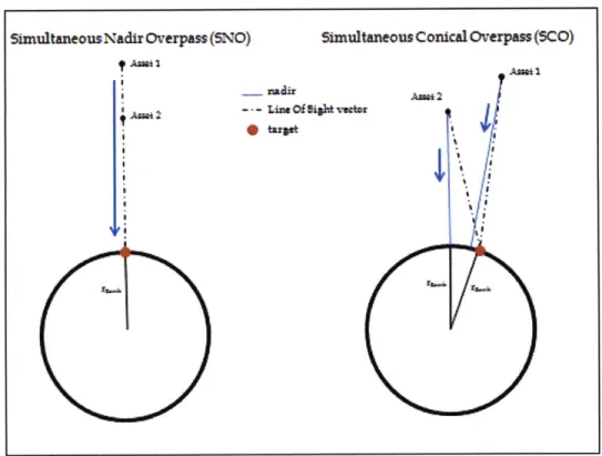
itself, which is the reason Simultaneous Nadir Overpasses (SNOs) have become a common way
to choose simultaneous viewings post facto [22].
SNOs are moments in time where two (or more) satellites at different altitudes pass
directly over the same location on the Earth almost simultaneously (usually within sixty
seconds). This means that data collected at these times by each asset involved are from the same
angle, and this makes post-processing and calibration considerably easier. Simultaneous
Conical Overpasses (SCOs) [23] can also be used. SCOs occur when the sensors involved are not
necessarily pointing towards nadir when the overpass occurs. This means that the observations
are taken at different angles and through different portions of the atmosphere. There are more
opportunities for these viewings, but the task of calibration becomes more difficult. The figure
below depicts examples of a SNO and a SCO:
Simultaneous Nadir Overpass
(SNO)
Asa0*I
Simultaneous Conicalh-erpass(5C)
i~aeil~ An02
~
Figure 2-5: Simultaneous Nadir Overpasses (SNOs) and Simultaneous Conical Overpasses (SCOs)
33
The concepts discussed above apply to the IC world as well. The value of highly
accurate weapons is lessened if intelligence cannot determine target locations accurately and in a timely manner. IC collection assets are more likely to have fine resolution sensors given that their objectives include surveying specific structures and tracking individuals, resulting in a smaller viewable region and fewer opportunities for observations. Thus, the nature of these missions emphasizes the need for coordination among available assets. A dynamic and coordinated planning system could enable near-real-time observation of TSTs by using the sensors of many single-mission planning systems.
Currently, however, most coordinated observations are taken post
facto
from archived data, with little or no real-time coordination generally occurring across sensors. The issue is summarized most succinctly in the following excerpt from the EOS Science Plan document:"Simultaneous observations with a group of sensors on the same platform (satellite)... taken
together, improve either the accuracy or the scientific content of observations in comparison with
measurements from a single instrument. This strategy depends on a close coordination in space
and time, and is generally easier,
if
not absolutely required, on a single satellite." [2]
As a result of the difficulty of coordination, sensor systems are inefficiently utilized compared to what could be achieved if they were coordinated.
2.1.3.3
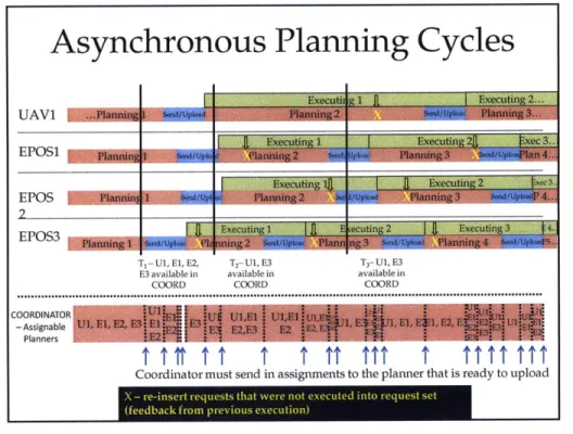
Asynchronous Systems
The way in which these independent missions are managed presents yet another complication; it also means that these missions have their own planning cycles and methods. Planning algorithms, the times at which newly-created plans are uploaded to the assets, and even maintenance periods, differ in different missions. These systems have their own planning objectives and carry out those objectives on their own schedules. The figure below depicts this feature of current operations:
Asynchronous Planning Cycles
UAV SAT1 SAT2 SAT3 TimeFigure 2-6: Asynchronous Planning Cycles
This figure illustrates a notional scenario where there are four independent planners; one plans
a UAV mission, while the other three plan satellite missions. Each planner operates on its own
schedule in that each creates, uploads, and executes plans at different times. Times at which
satellites are unavailable due to scheduled maintenance could also be included in this diagram,
which would add to the complexity of the problem.
2.1.3.4 User Communities
Another real-world issue to consider in understanding this problem is the existence of
disparate user communities. Currently, each community, whether it consists of scientists, news
offices, military personnel, etc., searches for a sensor platform that would satisfy its collection
need independently. Not only do they do so independently, but users begin to develop
preferences for certain platforms. This could occur because the platform usually provides
satisfactory data when it is requested, or simply because the user does not know that other
platforms can provide the same or better service. Figure
2-7
illustrates the way in which users
most often interact with independent mission planners.
Current Operations
Users Single Mission Planners Assets
Planning System 2
Planning System 3
Syse nJ
Figure 2-7: Current User Interaction with "Stovepipe" Systems. Adapted from [24].
In fact, it is most often the case that users rarely approach more than one planner when trying to obtain the data they desire. This behavior enforces the "stovepiped" nature of current
operations.
2.1.4 Future Operations Framework
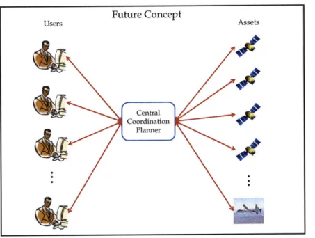
It would be beneficial for users if the coordinator could schedule tasks on all assets, air, space, and ground, in a synchronous manner where all assets are subject to the same planning cycle, the coordinator's planning cycle. All users seeking some data that could be obtained either from past or future observations would use the coordinator to find what they need. However, as discussed above, current operations do not provide this context. A transformation to this framework would require an overhaul of organizational structure and this is unrealistic, at least in the near future. It is difficult to imagine an environment where, for example, NSA,
NGA, and Central Intelligence Agency (CIA) surveillance assets plan their daily missions in a
coordinated manner. However, a goal of this thesis is to demonstrate the benefit that
coordinated planning could provide, even in an asynchronous and hierarchical environment. Below, we present a diagram to illustrate the future operations framework:
... . ... . ... .... ....
Figure 2-8: Future Framework of Centralized System
2.2
The Coordination Planner within Larger Frameworks
2.2.1 Collection Management Process
According to the Open Geospatial Consortium (OCC), collection management is defined
as "utilization and coordination of the resources involved in collecting information"[25].
Collection management is a process that extends beyond coordinating planning of assets. It
involves clearly defining and refining information and collection needs, creating missions that can
address those needs, planning to collect data to satisfy the needs, and translating that data into
more useful information. The following subsections briefly describe how the coordination
planner fits into this larger collection management process.
2.2.2 The Coordination Planner within a Web Service
The concept of coordinating the planning of sensor and imager activities and using the
data they collect applies to many areas of interest. This includes the aforementioned Earth
Science and IC realms. The data collection needs of each of these communities require very
similar inputs and outputs. As such, it is logical to generate a standard procedure by which
users may access sensors for any objective they wish. The Open Geospatial Consortium (OCC)
has developed such standards for providing web service, one of which is the Sensor Planning
Service (SPS), which allows web access to various sensors and the data collections they make.
Future Concept
AssetsThe coordination planner could fit into an automated system that begins with a user approaching the coordinator in a web-based service as specified by the OGC.
When a user invokes an SPS, he might request information on a topic of interest from historical data, or he might try to acquire new information through submitting a request to various surveillance/reconnaissance assets through the web service. All requests made by the user are exactly that - requests -not guarantees of access to past information or of successful asset assignments. The user makes requests to the web service, and the planner within the web service chooses which requests to satisfy (i.e. plan for) such that the science or intelligence value of the decisions in each planning period is maximized. Initially, the user could search for
information on any topic or use the web service to refine their request. The user accesses the web service, which then allows the user to choose one of the following three options:
Option 1: The user is asked to choose a time window in which to schedule a new request Option 2: The user is given a list of topics on which the system can find data, including categories for current events of interest (i.e. fires, floods, hurricanes, etc).
Option 3: The user has an idea for a request but only in general terms, and would therefore like an advanced request form that helps the user to refine their search. For the remainder of this thesis, we assume users have chosen Option 1 and input their request information. When the coordinator has reached some threshold of requests received or time elapsed since the last planning cycle, the coordinator begins planning the collection of data to satisfy these requests. The coordination planner must choose which requests to allocate to the sub-planners, and must give feedback to the users to alert them when their requests have been scheduled.
2.2.3 The Coordination Planner within a Sensor Web
Another example of a collection management process that could be enabled by an SPS is a Sensor Web. The concept of a Sensor Web was first described by NASA to take advantage of improvements in sensor and communications capabilities. The system is "capable of automated reasoning for it can perform intelligent autonomous operations in uncertain environments, respond to changing environmental conditions, and carry out automated diagnosis and
recovery" [26]. Thus, a Sensor Web is enabled by coordination of air, space, and ground sensors. It is important, however, to distinguish between a Sensor Web and "Distributed Sensors" or
"Sensor Networks." Distributed sensor networks simply gather the information obtained by
multiple sensors and communicate it to a central node. A Sensor Web, however, seeks a
closed-loop system in which the information gained by all assets is shared amongst the entire web, and
new observation plans are dynamically created based on this additional information. As such,
the stated goal of a Sensor Web "is to extract knowledge from the data collected and adapt and
react accordingly"[26]. A Sensor Web, then, has three components:
-
The sources of data, or sensor platforms that take observations
-
The processing nodes, where data are transformed into more useful information
-
The planning/tasking process, which uses the newly compiled information and creates
new tasks for the sensors to carry out, completing the cycle
A diagram of a notional Sensor Web, with interaction between various distributed sensors, is
shown in Figure 2-9 below:
SENSOR WEB INFORMATION
Figure 2-9: Sensor Web Diagram [26]
The benefits this type of system provides are clear. Tasks such as maintenance,
calibration, and downloads that generally disrupt a mission's planning cycle can be performed
by a Sensor Web while the system remains intact. In current operations, missions are hindered
by these tasks, but in a coordinated system this could be avoided. Moreover, the system can
39
react dynamically to information it processes to create new target lists to send to controlled assets, improving the timeliness and usefulness of observations. The following section describes scenarios that could find direct benefits from coordinated planning.
2.3 Real-World Scenarios
This section presents two real-world Earth Science scenarios in which the coordination planner, within a larger collection management process, could provide increased efficiency.
2.3.1 CLARREO Scenario
The Climate Absolute Radiance and Refractivity Observatory (CLARREO) Mission is headed by NASA and NOAA and is considered a key component of the future climate observing system. The mission is focused on taking climate observations, and considers
improving the accuracy with which Earth-observing sensors take these climate observations to be an important goal. CLARREO seeks to provide a highly-accurate record of climate data that will be used to improve climate prediction models as well as calibrate other sensors that observe Earth and is considered "one of the 4 highest priority missions recommended in the National Research Council (NRC) Earth Science Decadal Survey"[27]. The mission is currently scheduled for launch in 2016 [28].
The 2007 NRC Decadal Survey report, "Earth Science and Applications from Space: National Imperatives for the Next Decade and Beyond," outlined the mission objectives for CLARREO and suggested the mission/payload requirements. The Decadal Survey first estimated that three satellites would be needed, "two to obtain absolute, spectrally resolved radiance in the thermal IR and a 3rd to continue the IR absolute spectrally resolved radiance measurements,"[29]. The mission also adds CERES broadband instruments to the National Polar Orbiting Operational Environmental Satellite System (NPOESS) and NPOESS Preparatory Project (NPP). The first two satellites would require true 900 polar orbits to provide high
latitude coverage from low Earth orbit (LEO) and require 100 km footprints. The third satellite would also be in a 90' polar orbit, but in an orbital plane 600 from that of the other two
satellites. The NPP seeks to test new sensors that will eventually fly on the NPOESS, so their accurate calibration is imperative.
Since the Decadal Survey, however, CLARREO workshops (the latest in June 2009) have announced cutting the 3rd observatory to eliminate costs and to begin climate record keeping
![Figure 2-2: AIRS Image of Volcanic Ash, [14]](https://thumb-eu.123doks.com/thumbv2/123doknet/14117298.467130/27.918.224.692.106.486/figure-airs-image-volcanic-ash.webp)
![Figure 2-4: Satellites of the "A-Train" [19]](https://thumb-eu.123doks.com/thumbv2/123doknet/14117298.467130/31.918.154.766.668.948/figure-satellites-train.webp)
![Figure 2-7: Current User Interaction with "Stovepipe" Systems. Adapted from [24].](https://thumb-eu.123doks.com/thumbv2/123doknet/14117298.467130/36.918.259.668.103.408/figure-current-user-interaction-stovepipe-systems-adapted.webp)
![Figure 2-9: Sensor Web Diagram [26]](https://thumb-eu.123doks.com/thumbv2/123doknet/14117298.467130/39.918.179.730.484.912/figure-sensor-web-diagram.webp)
![Figure 2-11: EPOS Structure [30]](https://thumb-eu.123doks.com/thumbv2/123doknet/14117298.467130/43.918.159.760.166.542/figure-epos-structure.webp)