MANUSCRIT ACCEPTAT
Tracing the land-use history and vegetation
dynamics in the Mont Lozère (Massif Central,
France) during the last 2000 years: the
interdisciplinary study-case of Countrasts peat
bog
Gabriel Servera Vives ; Yannick Miras ; Santiago Riera ;
Ramon Julià ; Philippe Allée ; Hèctor Orengo ; Sandrine
Paradis-Grenouillet ; Josep Maria Palet
Revista
Quaternary International. Volume 353, 5 December 2014, Pages 123-139DOI
https://doi.org/10.1016/j.quaint.2013.10.048Disponible
en línia
10/11/2013Data de publicació
05/12/2014 Per citar aquest document:Gabriel Servera Vives, Yannick Miras, Santiago Riera, Ramon Julià, Philippe Allée, Hèctor Orengo, Sandrine Paradis-Grenouillet, Josep Maria Palet, Tracing the land use history and vegetation dynamics in the Mont Lozère (Massif Central, France) during the last 2000 years: The interdisciplinary study case of Countrasts peat bog, In Quaternary
International, Volume 353, 2014, Pages 123-139, ISSN 1040-6182, https://doi.org/10.1016/j.quaint.2013.10.048
Abstract
The Countrasts Bog (1400 m a.s.l.), located in the western part of the Mont Lozère medium mountain, has been the object of an interdisciplinary study combining multiproxy analyses which includes pollen, non-pollen palynomorphs (NPP), macrocharcoal particles,
sedimentology and geochemistry, with archaeological and archaeobotanical data. The high temporal resolution of the palaeoenvironmental study, with an average resolution of 40 years between samples, allows us to trace the landscape dynamics for the last 2000 years at a micro-regional scale. During the Roman Imperial period (ca. 1st–3rd centuries AD) local agropastoral activities were moderate, whereas metallurgical activities developed in the region as attested by geochemical records. Later, during Late Antiquity and Early Medieval periods (ca. 3rd–10th centuries AD), agropastoral activities increased and human impact produced major changes in local mire dynamics with the replacement of birch wooded bogs by sedge communities. During the High Middle Ages (ca. 10th–13th centuries AD), a complex system of land uses was established, based on different activities including ore smelting, forestry and agropastoralism, attested by pollen, NPP and
geochemistry data, as well as by archaeological, archaeobotanical and historical evidence. Since the Late Middle Ages (ca. 14th century AD), local metallurgical activities and forestry management decline have coincided with the expansion of grazing in uplands. This new land use favored the expansion of upland grasslands and heathlands and triggered the establishment of an open-landscape during the Early Modern Period (ca. 15th–18th centuries AD). At the end of the 19th century and the 20th century, agropastoral activities declined while reforestation was carried out.
1. Introduction
Numerous studies combining palaeoenvironmental and archaeological data have been done in southern Europe with the aim to better characterize past landscape changes. Such integrated approaches have been undertaken both in Mediterranean littoral plains (Riera and Palet, 2005; Court-Picon et al., 2010; Palet et al., 2012a) and in high mountain areas such as the Alps (Haas, 1996; Walsh et al., 2005, 2014; Court-Picon et al., 2007; Moe et al., 2007) and the Pyrenees (Rendu et al., 2013; Miras et al., 2007, 2010a; Ejarque et al., 2010; Palet et al., 2007; Orengo et al., 2013). Nonetheless, these kind of studies have scarcely been applied in medium mountain areas (Gauthier, 2002; Miras et al., 2004; Miras et al., 2003; Trément et al., 2005; Surmely et al., 2009; Breitenlechner et al., 2010; Jouffroy-Bapicot, 2010), being especially limited in the mid-elevations of the Mediterranean region (Currás et al., 2012).
Mont Lozère constitutes an example of such medium Mediterranean mountains, reaching a maximal altitude of 1690 m a.s.l. Several studies have been carried out in Mont Lozère in order to further comprehend the palaeoenvironmental evolution and human activities triggering landscape shaping. In this sense, palynological studies have mainly been focused on the characterization of the Holocene vegetation history (Beaulieu and Gilot, 1972; Beaulieu, 1974; Beaulieu and Pons, 1979; Reille, 1988). Recently, Pulido (2006) started to deal with the history of human activities and its consequences in environmental changes. In the study of human practices in the Mont Lozère mountain, metallurgy has received special attention due to the rich archaeological evidence of such activities (about 230 charcoal kilns and 80 ore-smelting sites have been identified) indicating that metal extraction was a relevant activity in the area (Allée et al., 2010; Bailly-Maître, 2010; Ploquin et al., 2010; Ploquin et al., 2005). In this context, the role of other human activities in the landscape shaping of Mont Lozère (such grazing and cropping) has been neglected, even if the relevant role of the mountain in local and regional agropastoral practices is historically attested as have been recently recognized, as this region has been listed in
UNESCO World Heritage for its “pastoral landscape”. The most relevant landscape fingerprint of grazing is probably the grasslands which expand in the summit areas. Such vegetation formations have been the object of great debate as they have been interpreted as the result of climate conditions (Braun-Blanquet, 1923; Lemée, 1943) or pastoral pressure (Beaulieu and Gilot, 1972; Reille, 1988, 1990; Allée and Paradis-Grenouillet, 2011).
The study of the Countrasts sector has a special relevance in characterizing the landscape history of the Lozère Mountain, as it is located in the contact area between the summit pasturelands and woodlands. In this sense, the Countrasts Bog is located close to the “draille” of Margueride (Fig. 1), one of the main transhumance paths of the region, mentioned at least from the Late Middle Ages (Hélas, 1979; Clément, 1983; Allée, 2003; Biber, 2010). The pastoral relevance of the Countrasts area has been reinforced by archaeological excavations carried out in the area. Countrasts is one of the most suitable areas for the study of local and regional husbandry. Furthermore, charcoal kilns and smelting sites have been encountered in this sector (Fig. 1), a fact that indicates that forestry and metallurgical activities were also carried out in historical times (Allée et al., 2010; Paradis-Grenouillet et al., 2011).
1. Download full-size image
Fig. 1. Map showing the location of the Cévennes region in the Massif Central, the main vegetation features and land uses of the Mont Lozère range, the location of the Countrasts bog and the archaeological context. The vegetation categories are based on the Corine Land Cover.
This paper presents the results of the Countrasts micro-regional window, located in the western part of Mont Lozère. Peat record multiproxy analyses, combining palynology, geochemistry and, for the first time in the area, non-pollen palynomorphs have been integrated with other available archaeological evidence and written sources to write the landscape history for the last 2000 years. The present paper will contribute to
characterize human land-uses and the management of natural resources at local and micro-regional scales that triggered to the landscape shaping of Mont Lozère.
2. Regional setting
2.1. Physical and geological context
Mont Lozère is located in the Cévennes region (Languedoc-Roussillon, Southern France) which constitutes the southeastern limit of the Massif Central (Fig. 1) and the
northernmost limit of the Languedoc plain. The Mont Lozère range is a NW–SE major structure about 30 km long, ranging from 900 to 1699 m a.s.l. This crystalline relief results from the Hercynian orogeny and is surrounded by sedimentary rocks (Bouladon, 1960). In the summit areas, the granite forms felsenmeer of rounded blocks. The relief of Mont Lozère shows overall smooth slopes and plain summits where concaves occupied by peat bogs are frequent (VVAA, 2008). In the contact zone between schist and dolomites, mineral resources, mainly argentiferous galena, are abundant (Baron et al., 2006). The climate in Mont Lozère is characterized by a montane regime with noticeable
Mediterranean influences and the predominance of Western winds. The climate influence of the Mediterranean Sea is evident in the formation of deep depressions mainly during spring and autumn. However, towards the west and the north, the climate becomes gradually more influenced by an oceanic regime characterized by more regular rainfall over the year (Jestin, 1998). A mean annual temperature of 3.2 °C and mean annual precipitation of ∼1600 mm are recorded, the southern slope being the moister one as the mountains act as a barrier of precipitation from the Mediterranean Sea (Sosa et al., 1990; VVAA, 2007).
The vegetation of the Cévennes (Fig. 1) is characterized, between 400 and 700 m a.s.l., by the occurrence of deciduous oak forests formed by Quercus pubescens and Quercus
petraea, with the presence of chestnut cultivars (Castanea sativa). Fagus sylvatica make up most of the natural forests above 900 m a.s.l. and in some areas, beech can appear mixed with Abies alba (Jestin, 1998). These woodlands reach maximum altitudes of about 1300 m a.s.l., an altitudinal limit which coincides with the distribution of medieval smelting sites and charcoal kilns (Allée et al., 2010) (Fig. 1). In the upper plateau, short-grass prairies (Nardetea strictae) are formed by Nardus stricta and partially colonized by shrubs such as Cytisus oromediterraneus, Calluna vulgaris, Vaccinium myrtillus and Genista purgans (Jestin, 1998; VVAA, 2007). These upland communities are wind-beaten and crisscrossed by herds during the summer season (Braun-Blanquet, 1952). Such herb communities have
historically been grazed by the transhumant flocks. Conifer forests (mainly Pinus
sylvestris) were planted predominantly in the southern slope during the second half of the 19th century and the 20th century, and partially reforested the upland abandoned
pastures (Saboulin Bollena, 1983; Jestin, 1998). Heathlands of Calluna vulgaris, Vaccinium myrtillus, Erica cinerea and Genista sagittalis occupy all altitudes. Otherwise, arable fields are present in the foothills and valleys, near the villages, under 1200 m a.s.l., and they are currently mainly used for herb fodder production.
2.2. Archaeological and historical background
Mont Lozère is part of the ancient territory of the Gabali, a pre-Roman tribe that was subdued by the Roman army in 52 BC (Trintignac, 2012). Archaeological evidence dating back from de Roman Imperial period (1st to 2nd centuries AD) exists in the region, such as many “villae” located in the lowlands between 800 and 1000 m a.s.l. (Trintignac, 2012). Two radiocarbon dates obtained in an occupation layer in a hut attached to a large enclosure near the Countrasts bog indicate the human presence between ca. 250 and 440 cal. AD. These data suggest the pastoral use of the area during Late Antiquity (Palet et al., 2012b). In the Early Middle Age, Mont Lozère was the boundary between the
Visigoths and the Frankish kingdom (Hélas, 1989). This period corresponds to the development of feudalism, a process that entails the proliferation of local elites (Hélas, 1979, 1989). The pastoral structure nearby the Countrasts bog has furnished two
radiocarbon dates between ca. 550 and 900 cal. AD, underlying the continuity of pastoral activities in the area during the Early Middle Ages (Orengo et al., 2011; Palet et al., 2012b). Between the 11th and the 13th centuries the Gévaudan (Lozère department) followed the overall expansive trend in Europe, which implies demographic and farming expansion and technical progress (Hélas, 1989). In addition, monastic orders expanded their control to large land properties, playing an important territorial and economical role in this area. The foundation of the Commanderie of Gap Francès by the order of the Hospital of St John occurred during the 12th century. This monastery acquired large properties in both slopes of Mont Lozère (Hélas, 1989), where it pursued extensive animal husbandry activities (Bronstein, 2005). The relevance of agropastoral activities in highlands is corroborated by the excavation of a hut nearby Countrasts bog, which furnishes a radiocarbon date of the 13th century (Palet et al., 2012b).
Metallurgical activities and charcoal production occur during the Late Medieval period, as indicated by the abundance of charcoal kilns and slag sites in Mont Lozère (Fig. 1), dated to the 11th and 14th centuries (Allée and Paradis-Grenouillet, 2011; Paradis-Grenouillet, 2012). These activities are linked to the mining exploitation of ore resources located in the southwestern slopes of the range (Baron et al., 2006). During the 14th century, land-use structures followed the emphytheutic leases, a contract that is usually linked with the development of the transhumance in the region (Hélas, 1989). In accordance, several transhumance tracks (called “drailles”) crossed the Lozère range linking the Languedoc plain with the Massif Central mountain pastures (Clément, 1983; Biber, 2010). The Ancient Regime implied a further central political control and entailed the diversification of land uses and economical activities which include agropastoralism, chestnut cultivation, sericulture and textile production (Joutard, 1989). The occurrence of grazing in highlands is attested by a pastoral structure of the Countrasts area dated to 1491–1602 cal. AD (Orengo et al., 2011). This period is also marked by the Religious confrontations, mainly that of the Camisards wars between the Protestants and the Catholics over the Cévennes region. During the second half of the 18th and 19th centuries, a demographic increase occurred as a result of the development of industrial complexes and coal extraction (Joutard, 1989). Mining activities expanded during the second half of the 19th century, as for instance the Bleymard complex in the Mont Lozère devoted to lead and zinc
productions (Trintignac, 2012). However, from the second half of the 19th century and the first half of 20th century, the Cévennes region experienced a movement of population toward urban areas while transhumant activities decline, a process that plunged the area into a deep demographic decline (Marty, 1983). At the beginning of the 1970s, the
National Park of the Cévennes was created.
3. Materials and methods
3.1. Study area and field sampling
The Countrasts bog is located at 1400 m a.s.l. in the westernmost Mont Lozère range (Fig. 1). The surface of this small mire of about 1 ha is characterized by a
micro-topography alternating grass and heaths hummocks with hollows. The mire is currently surrounded by sparse individuals of Pinus sylvestris and Pinus uncinata. In September 2009, a 114 cm long core was obtained using a 50 cm × 5 cm hand-operated Russian corer. The studied core was extracted from the central part of the mire, where the highest peat accumulation above a sandy silt level was achieved. Cores extracted were stored in a cold room at 3 °C, prior to sampling the record at 1 cm intervals in the laboratory. A high
resolution (average temporal resolution between two samples of 40 years) multiproxy study has been implemented, which includes pollen, non-pollen palynomorphs (NPP), macrocharcoal particles, sedimentology, and geochemistry. Eight radiocarbon dates have furnished an accurate chronological framework which allows the integration of
palaeoenvironmental data with archaeological, archaeobotanical, and historical evidence. 3.2. Pollen, NPP and macrocharcoal particles
Peat samples measuring 1 cm3 were treated for pollen and NPP analyses using standard extraction techniques (Faegri et al., 1989) and adding Lycopodium clavatum spore tablets to calculate pollen and NPP concentrations (Stockmarr, 1971). Pollen samples were analyzed at intervals of 2 cm along the core. A minimum amount of 450 dry land pollen grains were counted from each sample. Pollen and NPP relative values were calculated as percentages of total land pollen sum which includes pollen from vascular plants excluding local taxa, namely Salix, Cyperaceae, hydrophytes (Equisetum, Nuphar, Myriophyllum and Potamogeton), Pteridophyta and Shpagnum. Salix has been excluded from the pollen sum due to the abundance of immature pollen clumps and because it is mainly recorded as short-living peaks. These data suggest the local overgrowth of willow. In this sense, Salix pollen could be attributed to Salix repens, a common species growing on peat bogs of the area (Jestin, 1998; VVAA, 2007).
Pollen concentrations are expressed in grams of dry sediment. Pollen and NPPs were identified and counted using a Nikon 50i microscope at ×500 and ×1000 magnification. Immature pollen clumps have been counted separately as these aggregates could furnish additional arguments about local presence of taxa because of their low dispersal capability (Riera, 1993; Prieto, 2000; Stolze et al., 2012). Pollen clumps were included in the pollen counts as single grains and they have been independently represented in the pollen diagram. Macrocharcoal particles with a diameter >200 μm were counted using a Nikon binocular microscope at ×80 magnification after dispersion and sieving at 200 μm 1 cm3 of sediment. Charcoal values are expressed in number of particles by g of dry sediment (Carcaillet et al., 2001). Pollen and NPP identification were carried out using published illustrations and morphological keys (e.g. Punt et al., 1976–2009; van Geel, 1978, 2001; Valdés et al., 1987; Moore et al., 1991; Reille, 1992–1998; Beug, 2004; van Geel and Aptroot, 2006). Cerealia grains are defined as Poaceae grains exceeding 40 μm in diameter, with an annulus diameter higher than 12 μm (Faegri et al., 1989). Cannabis–t has been classified using the size criteria defined by Mercuri et al. (2002). The sum of apophyte taxa includes classical pollen types indicative of human impact (Behre, 1981), additional human-indicator pollen taxa identified by modern pollen analogue studies of mountain areas (Court-Picon et al., 2006; Mazier et al., 2009; Miras, 2009; Brun, 2011; Ejarque et al., 2011) and synanthropic plant species described in local floras (Jestin, 1998; VVAA, 2008).
Diagrams were constructed using the C2 program (Juggins, 1991), and stratigraphically constrained cluster analyses of percentage pollen values were carried out using the PAST program (Hammer et al., 2006) to define local pollen and non-pollen palynomorphs assemblage zones (abbreviated as LPAZ and NPPAZ, respectively). In order to avoid redundancy, NPPAZ are assimilated to LPAZ in the discussion because both dendrograms record similar depths of zone boundaries.
3.3. Organic matter content and geochemistry
Water content in sediments was calculated using an oven at 60 °C. After drying, the samples were also used to calculate the weight percentage of organic matter (OM) by
weight loss achieved after 4 h of burning sediment successively at 550 °C and at 950 °C in a muffle furnace (Dean, 1974; Heiri et al., 2001). The geochemical analysis for Na, Ca, Sr, Ti, Al, Fe, Mn, Co, Ni, Cu, Zn, As and Pb was performed every 2 cm using an inductive coupled plasma ICP-AES at the Institute of Earth Sciences-CSIC (Barcelona). Treatment of samples for geochemical analysis was performed at the U-series dating Laboratory of the Institute of Earth Sciences. After desiccation, samples were milled in an agate mortar for x-ray diffraction in order to determine the mineralogical composition. Later, these samples were used for total acid dissolution in 25 ml PTFE beakers using the procedures defined by Luo and Ku (1991). Geochemical values were normalized using the Al content in order to allow comparisons with already published data (Baron et al., 2005). Geochemical zones were also established using the PAST program (Hammer et al., 2006).
3.4. Radiocarbon data
Eight AMS radiocarbon dates were obtained at the Center for Applied Isotope Studies (CAIS, University of Georgia, USA). Dated material corresponds to macroremains which include wood, charcoal and seeds, as well as bulk sediment when needed. Macroremains were selected under a binocular microscope after sieving bulk sediment in order to eliminate roots, especially in levels corresponding to sedge-dominated mire. Radiocarbon results were calibrated using the Intcal09 curve (Reimer et al., 2009). The age-depth model was constructed by fitting a smooth spline curve using the “CLAM” program (Blaauw, 2010) written in the statistical package “R” version 2.14.2 (R Development Core Team, 2011).
4. Results
4.1. Chronological model
Radiocarbon and calibrated dates are shown in Table 1. The age-depth model relies on eight 14C AMS measurements (Fig. 2). Furthermore, two supplementary dates have been incorporated in the upper part of the age-depth model on the basis of the correlation between geochemical data and the local mining and smelting history. In this sense, the increase in metal pollution at 12 cm depth is coeval with the extension of local extractive activities during the end of 19th century and the beginning of the 20th century, and the metal peak at 8 cm depth can be attributed to the maximum zinc extraction in the area reported between the 1950s and 1970s (Joutard, 1989; Rolley and Wienin, 2001; Monna et al., 2011; Trintignac, 2012). Moreover, the model incorporates the date 2009 A.D. for the modern surface of the bog. Radiocarbon dates indicate that peat sedimentation started in the beginning of the 1st century AD and has supported continuous sedimentation spanning the last 2000 years (Fig. 2).
Table 1. AMS 14C results from the Countrasts record. Sample ID Depth
(cm) Material
δ13C,
‰ Date BP Calibrated age 2 sigma
UGAMS-8008 37–38 Bulk sediment −27.9 720 ± 25 1257–1298 cal AD
UGAMS-6552 45–46 Bulk sediment −29.7 670 ± 25
1277–1315 cal AD 1356–1388 cal AD
Sample ID Depth
(cm) Material
δ13C,
‰ Date BP Calibrated age 2 sigma
UGAMS-8859 55–56 Macroremains −27.3 1230 ± 20 765–876 cal AD 693–748 cal AD
UGAMS-8860 73–74 Macroremains −26.7 1670 ± 20 333–423 cal AD
UGAMS-6551 77.5–79 Wood −29.4 1570 ± 25 424–547 cal AD
UGAMS-8010 93–94 Bulk sediment −28.6 1990 ± 25 43–63 cal AD
UGAMS-8861 97–98 Macroremains −29.7 1890 ± 20 63–141 cal AD
UGAMS-6550 112–114 Wood −28.8 1960 ± 25 3 cal BC-85 cal AD
1. Download full-size image
Fig. 2. Age-depth model of the Countrasts sequence showing the probability distributions for selected calibrated dates. The smooth spline model is represented as a solid black line and its 95% confidence interval as a grey band. Circles indicate extrapolated dates based on geochemical peaks of Zn and Pb.
4.2. Pollen and macrocharcoal zones (Fig. 3)
Cluster analyses allowed establishment of 5 Local Pollen Assemblage Zones. 4.2.1. C-1 (114–78 cm)
This zone is characterized by an AP/T ratio reaching the maximum values of the entire sequence (80%). Arboreal pollen is dominated by Betula (40%), Fagus (20%) and deciduous Quercus (10%). Other trees such as Corylus, Alnus, Abies and Pinus are present with moderate percentages, whilst occurrences of Juglans, Castanea and Olea are reported. Among the herbaceous taxa, Poaceae is dominant (8–20%), while hygrophilous taxa and anthropogenic pollen indicators are continuously recorded. The presence of Cyperaceae (8%) is accompanied by the sporadic occurrence of aquatic plants such as Equisetum, Isoetes and Potamogeton. In addition, sporadic occurrences of macrocharcoal particles (maximum values of 5 particles/g) are documented.
Two subzones can be distinguished. The lower one (LPZA C1a) is characterized by higher values of Betula (44%) and Fagus (24%), and by noticeable values of Sphagnum. The apophyte taxa such as Rumex acetosa-t, Plantago lanceolata-t, and Plantago major/media, record modest values. Pollen clumps of Fagus, Betula, Abies, Alnus, Poaceae, Potentilla erecta-t, Galium, Dipsacaceae and Sorbus are recorded. The upper subzone (LPZA C1b) is characterized by a slight decreasing trend of AP/T, mainly due to Betula (36–22%) and Fagus (20–12%) lowering. Cerealia and Poaceae (10–19%) increase while sporadic notations of Sinapis-t are recorded. Many pioneer trees such as Corylus, Pinus and Juniperus record slight expansions. Only Betula clumps have been reported within this zone.
4.2.2. C-2 (74–42 cm)
The main feature of this zone is the retreat of some arboreal taxa that resulted in an AP/T decrease from 70 to 23%. This reduction is mainly due to the sharp decline of the Betula percentages (22–5%). Concentration values of Fagus and Betula decrease, whilst
percentages of deciduous Quercus, Corylus, and Abies record slight retreats. Fagus remains the main recorded tree taxa with values ranging from 8 to 25%. Castanea records
continuous values while Juglans is punctually recorded. NAP include the expansion of Calluna, Poaceae (max. 40%) and many heliophilous herbaceous taxa such as
Scrophulariaceae, Artemisia, Asteroideae, and Cichorioideae. Potentilla erecta-t and Apiaceae also show an increasing trend. In addition, the first notations of Secale are
recorded. Cyperaceae (max. 80%) records a sharp increase. Pollen clumps of Salix, Calluna, Poaceae, Cyperaceae, Potentilla erecta-t, Artemisia and Apiaceae are present.
Macrocharcoal particles record regular occurrences, reaching higher concentrations in the LPZA C2b (26 particles/g).
Three subzones have been distinguished in this zone. In LPZA C2a, Fagus records values of 25%, but this taxon declines in the upper subzone (C2b). In LPZA C2a, Ranunculus acris-t shows a short-living peak, while LPZA C2b records the increases of Potentilla erecta-t, Calluna and Sphagnum. Both subzones are characterized by an increase in anthropogenic pollen indicators such as Cerealia, Rumex acetosella-t, Rumex acetosa-t, and Plantago lanceolata-t whilst other apophytes, such as Sinapis-t and Polygonum aviculare-t are sporadically recorded. The topmost subzone (LPZA C2c) shows a general retreat in synanthropic taxa, including Cerealia. The expansion of some trees (Betula, Corylus and Pinus) and Apiaceae is also representative of this subzone, while Salix shows a significant peak (max. 50%). Furthermore, Cyperaceae values decrease.
4.2.3. C-3 (39–27 cm)
Tree pollen shows an oscillating pattern, mainly due to the fluctuations in Fagus (1–20%) and Betula (2–14%) values. However, Fagus frequencies have a general moderate decline whilst Salix and Abies disappear. Calluna (3–30%) and some heliophilous trees (e.g. Corylus and Betula) expand in the beginning of the zone, while Juniperus increase in the upper samples. The consolidation of Castanea and Olea curves occurs, whereas Juglans increase. In NAP pollen, Poaceae (40%) expands. Potentilla erecta-t and Apiaceae gradually diminish. Ruderal and nitrophilous taxa show an increasing trend while Centaurea cyanus-t is recorded for the first time. Crop taxa increase as evidenced by the renewal of Cerealia (4%) and point notations of Secale, Vitis and Cannabis-t. Among hygrophilous and aquatic taxa, Cyperaceae shows a general decreasing trend, while Sphagnum increases. Pollen clumps of Calluna, Poaceae and Cyperaceae are also present. Macrocharcoal particles (147 particles/g) values increase along the zone.
4.2.4. C-4 (25–22 cm)
This zone shows a marked increase in Calluna (50%) and a general decrease in all arboreal taxa, except for deciduous Quercus. Fagus shows the lowest values of the entire sequence while tree crops expand. Poaceae (12%) decreases and Apiaceae almost disappears. Anthropogenic pollen indicators, such as Rumex acetosa-t and Plantago lanceolata-t or other heliophilous herbs, such as Cichorioideae and Scrophulariaceae, show slight decreases. Cerealia values decrease. Cyperaceae and Sphagnum report very low values. Clumps of Calluna and Poaceae occur at the time that maximum macrocharcoal concentration in the sequence is attested (max. 305 particles/g).
4.2.5. C-5 (19–1 cm)
The arboreal pollen increases from 15 to 50%, mainly due to the rise of Pinus percentages from 7 to 33%. Noticeable percentages of deciduous Quercus and Castanea are also reported. Other arboreal taxa, such as Fagus and Olea are present in this zone with low values. Calluna (4–15%) shows a sharp fall while ruderal and nitrophilous taxa, such as Rumex acetosa-t, Plantago lanceolata-t, and Artemisia, decrease in the upper part of the zone. This is the case also for Cerealia, while Secale disappears. Pollen aggregates of Pinus, Poaceae, Cyperaceae and Potentilla erecta-t appear, whereas macrocharcoal particles disappear.
4.3. NPP zones (Fig. 4) 4.3.1. C-1
Fungal spores dominate the NPP assemblage. Undifferentiated ascospores and Sordaria (HdV-55) show noticeable values. Point notations of many coprophilous fungi such as Sordariaceous ascospore, Sporormiella (HdV-113), Podospora (HdV-368) and Apiosordaria verruculosa (HdV-169) occur within the zone. Occurrences of Byssothecium circinans (HdV-16), HdV-18 and Endophragmiella C (TM-227) fungal remains are noted. Also noteworthy are point notations of the mitosporic fungi Trichocladium (HdV-572), Ustulina deusta (HdV-44) and Brachysporium (HdV-360). In addition, the presence of oocysts of the Neorhabdocoela (Turbellaria class undifferentiated, Gyratrix hermaphroditus and
Micodalyellia armigera) is reported in this zone; while algal remains such as Spirogyra (HdV-132) and Mougeoutia (HdV-135), and the rotifer Conochilus natans are more sporadically recorded.
The differentiation between the NPPAZ C1a and C1b is due to the increase of coprophilous fungi (Sordaria, Sporormiella, and Cercophora), Clasterosporium caricinum (HdV-126) and the continuous curves of HdV-123 and spermatophore of Copepoda (HdV-28) in subzone NPPAZ C2b.
4.3.2. C-2
A more diversified NPP assemblage is recorded in this zone. There is a significant rise in coprophilous ascospores (max. 50%), mainly Sordaria, Sporormiella, Podospora and Apiosordaria verruculosa. High percentages of other fungal spores, such as HdV-18 (max. 35%) and HdV-123 (max. 30%), are also found. Clasterosporium caricinum expands but records an oscillating pattern. Point notations of Spirogyra and Mougeotia are recorded. Among faunal remains, the dominance of spermatophore of Copepoda is attested, while the Tardigrada Macrobiotus ambiguus and Macrobiotus hufelandi show moderate values and Amphitrema flavum protozoa (HdV-31A) increases.
The NPPAZ C2a is characterized by a rise in Apiosordaria verruculosa (2–13%), HdV-18 (6–25%) and Amphitrema flavum. In addition, a high diversity of coprophilous fungi is reported, including the occurrence of Sporormiella and HdV-123 and individual Geoglossum sphagnophillum (HdV-77A). The NPPAZ C2b records the decline in
coprophilous fungi frequencies and diversity (e.g. Sordaria and Sporormiella), as well as the regression of HdV-18 and HdV-123 types. Clasterosporium caricinum expands whereas Glomus (HdV-207) and Meliola ellisii (HdV-14) are present at a trace level. Diversity and frequencies of testate amoeba and faunal remains become higher. The NPPAZ C2c shows an increase of coprophilous fungi with a peak of Sporormiella (9%) at the beginning of the zone. A marked increase of Byssothecium circinans is also attested. Algal remains and Protozoa are scarce in this subzone, while faunal remains are still abundant (e.g.
Conochilus natans, oocytes of Neorhabdocoela and Micodalyellia armigera). The presence of eggs from the endoparasite Trichuris are noted in the two upper subzones.
4.3.3. C-3
The richness of the NPP assemblage decreases. Only four coprophilous fungi are noted, recording low values. Among these, Sordaria (2%) and Sporormiella (0.5–1%) are present in continuous curves, whereas Sordariaceous ascospore and Podospora appears
sporadically. Clamydospores of Glomus expand and a peak of Tilletia sphagni is reported. Noticeable values of spermatophore of Copepoda and Byssothecium circinans are recorded. 4.3.4. C-4
In this zone, the diversity of NPP is the lowest in the entire sequence. The coprophilous fungi diminish: Sordaria and Delitschia are the only types recorded. The presence of Byssothecium circinans, HdV-18 and Copepoda spermatophore is also observed with values below 1%. Individual Conochilus natans and Neorhabdocoela oocytes are also reported. 4.3.5. C-5
A more diversified fungal spore assemblage and an increase of algal remains characterize this zone. Undifferentiated ascospores expand (max. 25%), while several coprophilous fungi, mainly Sordaria and Sporormiella, show significant values in the first part of the zone. A rise of Glomus is also recorded, while HdV-123 increases in the upper samples. Furthermore, a peak of Brachysporium (HdV-360) is attested, reaching values of 14%.
Among algae, Zygnema (HdV-314) increases while Mougeotia occurs. Assulina seminulum expand while individual faunal remains such as Conochilus natans, Neorhabdocoela oocytes, and Macrobiotus hufelandi are also reported.
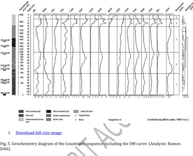
4.4. Geochemistry and organic matter content (Fig. 5)
X-ray diffraction analyses of the detrital fraction show a homogeneous composition of the record, characterized by high contents of quartz, albite and illite. In addition to weathered minor mineral phases, the presence of gehlenite and other feldspars as microcline have also been attested. The elemental composition of the Countrasts samples shows two types of relationships, one following the main mineral composition in the area, and the second more linked to elements related to metallurgical activities. The correlation matrix underlines the correspondence among the major chemical elements forming the igneous rocks of Mont Lozère. In this sense, Ti, Al, Sr, Fe, and Na show high positive correlation values among themselves and high negative correlation values with OM. With the exception of Zn, metals are closely correlated, as for instance Pb, which correlates well with Co, Ni, As, Sr and Ba.
The sedimentological and geochemical analyses of the Countrasts sequence show important changes in composition which designate 5 zones. Zone 1 (113–83 cm) is characterized by high OM content (ca. 90%), low values of P and high Pb content. Zone 2 (83–53 cm) shows a decline in OM at 79 cm, which is concomitant to the lowest values in metal and alkaline elements. This zone starts with a general dilution phase both in OM and in elemental composition, concomitant with high Al concentration. Thereafter, a
progressive increase in Ni/Al, Ti/Al, As/Al, Co/Al, Sr/Al, Ba/Al, Ca/Al, OM and P/Al is recorded until 53 cm. Zone 3 (53–17 cm) records a progressive increase in Pb/Al and Fe/Al while Zone 4 (17–7 cm) shows the highest metal contamination, recording peaks of Pb/Al, As/Al, Co/Al, Ba/Al, S/Al, Ca/Al and Cu/Al at 12cm depth and peaks of Zn/Al, Fe/Al, As/Al, Ni/, Cu/Al and Mn/Al at 7cm depth. Zone 5 (7–1 cm) is characterized by the general decline of metal pollution, while Mn/Al increase.
5. Discussion
(
Figs. 3–6
)
Based on the integration of obtained multiproxy data with archaeological and historical evidence, five environmental phases can be recognized during the last 2000 years in Countrasts area. These phases reflect the main land uses and environmental changes in the local dynamic of this medium mountain sector.
5.1. Phase I (ca. 1st–3rd centuries AD): Moderate farming use with regional metallurgical activity
During this environmental phase, the local presence of birch communities is attested by Betula high pollen percentages and concentrations as well as the occurrence of pollen clumps (Fig. 6). The concomitant presence of Sphagnum and pollen clumps of Sorbus suggests the local development of a mountain birch wooded bog at this phase. The overgrown of birch trees onto the Countrasts mire is corroborated by the presence of Betula wood macroremains and the occurrence of NPP, such as Trichocladium, Ustulina deusta, Brachysporium and Endophragmiella C (Fig. 4), which have been interpreted as saprobe or parasitic fungi on woody substrates (Ellis and Ellis, 1985; Kiffer and Morelet, 1997; Cugny et al., 2010).
The presence of sedges and other hygrophilous pollen taxa such as Equisetum, Isoetes and Potamogeton, as well as the occurrence of wet-demanding NPP such as algae (Spirogyra, Zygnema and Mougeoutia) rotifers (Conochilus natans) and Tardigrada (Macrobiotus hufelandi and Macrobiotus ambiguus) suggest the prevalence of shallow but permanent water conditions (van Geel et al., 1980–1981; Wilmshurst et al., 2003; Borromei et al., 2010). The low grazing pressure in the Countrasts area during this phase is also indicated by the reduced percentages of coprophilous fungal spores and grazing pollen indicators (Blackford and Innes, 2006; Davis and Shafer, 2006; van Geel and Aptroot, 2006). This could explain the prevalence of oligotrophic water conditions in the bog (Manneville et al., 2006) as suggested by the low presence of the Neorhabdocoela oocytes including
Turbellaria, Gyratrix hermaphrodites, and Micodalyellia armigera (Fig. 4).
High pollen values and occurrence of pollen clumps of Fagus and Abies (Fig. 3) indicate that mixed beech–fir woodlands expanded near the Countrasts mire, suggesting that this forest predominated in the Countrasts range during Gallo-Roman times, reaching altitudes higher than present-day. Such woodlands are also reported during this period at similar altitudes in the Narses Mortes pollen sequence (Fig. 1) (Pulido, 2006). Noticeable values of deciduous Quercus pollen in Countrasts and Narses Mortes records indicate that
deciduous oak woodlands expanded at lower altitudes.
1. Download full-size image
Fig. 3. Selected pollen diagram of the Countrasts bog in relative frequencies (%). Absolute pollen concentrations are shown by white lines for Fagus and Betula (Analysis: Gabriel Servera Vives). During the Gallo-roman period, the low presence of pollen human indicators in the Countrasts record suggests a moderate development of farming activities in the western sector of the Lozère uplands and indicates that farming activities did not reach the Countrasts sector during the High Empire period. However, the sporadic occurrences of cereals, chestnut, and walnut in the Countrasts diagram suggest that arable lands probably expanded at lower altitudes (Fig. 6). Gallo-Roman villae were present in the Mont Lozère area. In this sense, the Finiols villae, located at 800 m a.s.l. and 7 km far from Countrasts, corroborates the development of these farming activities in the western lowlands of the range (VVAA, 2007; Trintignac, 2012).
Geochemical data records high concentrations of Pb/Al between the beginning of the era and the middle of the 3rd century AD (Fig. 6) suggesting ore exploitation in the region. According to these data from the Countrasts record, the nearby geochemical sequence of Narses Mortes indicates that intensive mining started in the area during the second Iron Age, at ca. 220 cal BC (Baron et al., 2005). On the basis of 206Pb/207Pb ratios at Narses Mortes, these authors suggest that lead exploitation ended at the beginning of the 1st century AD. However, the high lead concentration present until the 3rd century AD in both Narses Mortes and Countrasts records could indicate the continuity of lead mining during the Gallo-Roman period. In this sense, Gallo-Roman mining in the area is corroborated by written sources, as the ore richness of the Gabales territory was reported during the 1st century (Strabon, IV, 2.2; Trintignac, 2012). In conclusion, the data indicate that
agropastoral land use was mainly carried out in the lowlands and not the uplands during Gallo-Roman times, while mining activities are well attested in the region.
5.2. Phase II (ca. 3rd–10th centuries AD): enhancement of agropastoral activities in the Lozère uplands
During this environmental phase, a major change in the mire conditions occurred between ca. 250 and 915 AD which entails the substitution of the wooded bog by a patchy system of moorland and tall forb communities. This process of mire change occurred in three stages. In a first stage, between ca. 250 and 430 AD, the decrease of Fagus pollen percentages and concentrations suggests a deforestation process. The woodland clearances are
synchronous with the increase of local and regional grazing indicators (Fig. 6) and the recording of macrocharcoal particles indicating the occurrence of local fires (Carcaillet et al., 2001). At the same time, the slight but progressive decline of Betula pollen values, both percentage and concentration, may likely indicate that such openings could partially affect birch communities. Similarly, the nearby Narses Mortes pollen record shows forest retraction, as Betula and Fagus decline slightly at ca. 200-300 AD (Pulido, 2006). The slight increase of coprophilous fungi such as Sordaria, Sporormiella and Cercophora (Fig. 6) suggest that Countrasts bog started to be frequented by livestock for grazing (Blackford and Innes, 2006; Davis and Shafer, 2006; van Geel and Aptroot, 2006). The enhancement of human activities in the uplands of western Mont Lozère could have induced an increase in erosion during ca. 400–500 AD as can be deduced by the slight reduction of OM and the increases of Na/Al and Ti/Al (Fig. 6) which indicate an increase in clay input into the mire. All these data could indicate that human impact in uplands could lead to the increase in run-off or groundwater input (Moore, 1986). A pastoral hut near Countrasts bog furnished two occupation layers radiocarbon dated at 250–390 cal AD and 340–440 cal AD,
respectively (Palet et al., 2012b). These data indicate the enhancement of grazing activities in uplands during the 3rd and 4th centuries AD.
Otherwise, the increase of Cerealia percentage in Countrasts and its occurrence in the Narses Mortes record suggests the expansion of arable lands, probably placed in the lowlands of the range. This period of increasing farming activities is synchronous with the decrease of Pb/Al geochemical values at Countrasts (Fig. 6) and Narses Mortes, suggesting a decline in mining activities (Baron et al., 2005). In conclusion, late Roman period record an expansion of grazing activities in uplands and arable farming in lowlands, synchronous with a retreat in metallurgical activities.
In a second stage, during ca. 430–615 AD (LPZA C2a), the process of moorland formation evolved towards the expansion of sedge communities which replace the former birch wooded bog. Sedge growth is indicated by the increase of Cyperaceae pollen and the sharp decrease of Betula. Sedge development is also attested by the noticeable values of
Clasterosporium caricinum and HdV-18, which are fungal parasites of these plant communities (e.g. van Geel, 1978; van Geel and Aptroot, 2006; Mauquoy and van Geel, 2007; Cugny et al., 2010). In addition to this, the increase of Ranunculaceae, Ranunculus acris-t, Potentilla erecta-t and the occurrence of Calluna and Meliola ellisii ascospores corroborate the development of wet grasslands and heathlands in the Countrasts bog (van Geel, 1978), while the increase in Apiaceae may indicate the expansion of tall forb
communities. Oscillating water conditions may have predominated during this period as indicated by the disappearance of Sphagnum spores coinciding with the increase of HdV-123 and Copepoda spermatophore (van Geel, 1978). The concomitant occurrence of the endomycorrhizal Glomus and the dry-demanding Assulina seminulum suggest the local alternation of hollows and hummocks in the peat surface (Mitchell et al., 2001; Chmura et al., 2006; Ejarque et al., 2009; Lamentowicz and Obremska, 2010). The rise of
Turbellaria class (van Geel, 1978) indicates water nutrient enrichment that is also corroborated in the P/Al increase observed in geochemical analyses (Fig. 6).
The diversification and the increase of coprophilous fungi reach the highest values of the entire sequence at ca. 430–480 AD (van Geel et al., 2003; Cugny et al., 2010). This evidence indicates the enhancement of grazing in the mire that could contributed to increase
nutrient supply. Supporting this, a pastoral structure near Countrasts bog furnished a radiocarbon date of 545–637 cal AD, indicating the continuity of grazing activities in the uplands (Palet et al., 2012b). All these data suggest that flocks could now graze on the sedge fen because the availability of water and wet meadows rendered these mire plant communities attractive for the herbivores to pasture. In a former stage, woodland
clearances and grazing development in the catchment basin might have provoked the first hydrological changes that affected the birch woodland in the bog, as this assemblage is highly sensitive to hydrological regimes and water nutrient changes (Perera, 1996–1997; Manneville et al., 2006). Furthermore, such changes occurred in a context of a high hydro-sedimentary activity which occurred at ca. 450–600 AD (Allée, 2003) and that could contribute to the mire response to human disturbances. Multiproxy data indicate that human actions could gradually transform the mire, triggering a final stage of substitution by herb communities.
In a third stage, mire transformation culminated between ca. 740–960 AD, when the diminution of HdV-18 (a probable parasite of Eriophorum) and the increase of
Clasterosporium caricinum, a Carex fungal parasite (Fig. 4), suggest a change in the local plant communities resulting in the expansion of Carex. Synchronously, the increase of Potentilla erecta-t and the high values of Poaceae may indicate the development of moorland with the presence of hummocks. Pastoral activities are also attested in the area by the occurrence of pollen indicators such as Plantago lanceolata-t, Plantago
major/media and Urticaceae (Fig. 3), and coprophilous fungi such as Podospora, Sordaria and Sporormiella (Fig. 4). Furthermore, the presence of the endoparasite Trichuris reinforces the local presence of flocks (van Geel et al., 2003; Davis and Shafer, 2006; Ejarque et al., 2011). Pastoral activity in the surroundings of Countrasts area is also attested by archaeological work which reveals a pastoral hut attached to a large enclosure dated between the end of the 8th and the 9th centuries (Orengo et al., 2011). This grazing activity could also induce peat fertilization, as suggested by the increase in P/Al (Fig. 6) and NPP indicators of eutrophic conditions such as Anabaena and HdV-179 (van Geel et al., 1983, 1989, 1994).
1. Download full-size image
Fig. 4. Selected NPP diagram of the Countrasts sequence in relative frequencies (%). (Analysis: Gabriel Servera Vives).
These changes in the mire occurred in a process of opening up the landscape, as indicated by the decline of AP/T resulting from the retraction of the beech-fir forest during pollen subzones C2a and C2b (Fig. 3). This process led to the expansion of upland grasslands which occurred between ca. 615 and 960 AD (subzone C2b), as a result of grazing
practices, as suggested by the increase of trampling and nitrophilous taxa such as Plantago lanceolata-t and Rumex acetosa-t, and heliophilous taxa such as Artemisia,
Scrophulariaceae, Asteroideae and Galium (Fig. 3). This evidence is consistent with the palynological data of the Narses Mortes, where the culmination of this landscape openness has been also dated at ca. 800–900 AD (Pulido, 2006). Fagus woodland deforestation has also been reported during the Early Middle Ages in other pollen sequences of Mont Lozère, such as Le Peschio where this process is enhanced at ca. 750–900 AD (Pulido, 2006). Taken together, pollen data corroborate that this period corresponds to a phase of deep landscape change on both local and regional scales. Such a phase of woodland
deforestation during the Early Middle Ages is linked with the development of agropastoral activities, which have also been reported in other mountain areas of the Massif Central such as the Cantal, the Aubrac and Margeride (Beaulieu et al., 1982; Reille et al., 1985; Servelle and Galop, 2006; Surmely et al., 2009; Faure, 2012).
The increase of cereals during this phase at Countrasts, including the first occurrences of rye culture, also indicate the expansion of farming activities located at lower altitudes of the range, as also observed in the Narses Mortes, especially since ca. 600 cal AD (Pulido, 2006). This process is consistent with the progressive increase of Ti/Al, As/Al, Co/Al, Sr/Al, Ba/Al, Ca/Al, S/Al, Ni/Al and Fe/Al (Fig. 5) that may indicate the increase in regional airborne particles due to the temporal exposition of bare soils in arable fields of lowland areas.
1. Download full-size image
Fig. 5. Geochemistry diagram of the Countrasts sequence including the OM curve. (Analysis: Ramon Julià).
Both archaeological and palaeoenvironmental data suggest the expansion of agropastoral activities during the Early Middle Ages, which implies landscape openness and a deep human fingerprint in the shaping of the Mont Lozère landscape. In Countrasts, such
changes in land uses occur in a context of mining and metallurgical decrease in the area, as attested by the decline of Pb/Al values. In this sense, historical studies indicate that the presence of transhumant flocks from the littoral plain of Languedoc intensified from the 11th century and it has been suggested that long distance livestock mobility could be practiced earlier than the 10th century (Durand, 2003).
5.3. Phase III (ca. 10th–13th centuries AD): birth of a complex upland land use system combining forestry, metallurgy and agropastoralism
The decline of Cyperaceae during this environmental phase suggests the retraction of local sedge communities, while the increase of Apiaceae may indicate the development of dry tall herb communities. In addition, the continuity of Calluna, the disappearance of Isoetes and Potamogeton and the reduction of wet-demanding NPP such as Amphitrema flavum (Fig. 4) indicate the prevalence of drier oligotrophic conditions in the mire (Beyens and Meisterfeld, 2001; Mitchell et al., 2001). The increases in pollen values of Betula, Pinus and Salix (Fig. 3) and in the NPP Byssothecium circinans, an indicator of a woody substrate (Montoya et al., 2010), underline the reduction of water availability and the overgrowth of trees on the mire. Taken together, all this evidence indicates a progressive trend to drier conditions which is also corroborated by the decrease in OM content (Fig. 6). Accordingly to this trend, palaeoclimate records from the Jura Mountains and the center of Europe corroborate the prevalence of drier conditions between ca. 1000 and 1200 AD (Büntgen et al., 2011; Magny et al., 2011).
1. Download full-size image
Fig. 6. Multiproxy diagram of the Countrasts sequence. The environmental phases, pollen, NPP and geochemical zones are marked, while radiocarbon calibrated dates of the pastoral structures and the metallurgical activities period are also plotted.
In the Countrasts mire, the reduction of pollen human indicators suggests that grazing activities suffered a slight decline during this period, but this activity remained locally present as attested by the occurrence of coprophilous fungi (Sordaria, Sordariaceous ascospores, Sporormiella;
occurrences of Podospora, Arnium, Apiosordaria verruculosa and Coniochaeta cf. lignaria) (Fig. 4) and the presence of eggs of the endoparasite Trichuris (van Geel et al., 2003; Ejarque et al., 2011). These data suggest that pastoralism continued to be active in this western sector of the Lozère range during medieval times. Historical data also indicate pastoral activity in the Lozère. Monastic orders expanded in this area and controlled large land properties (Hélas, 1989; Bronstein, 2005). The establishment in the 12th century of the Commanderie of Gap Francès by the order of the Hospital of St John, which acquired important pro-perties in both slopes of the Mont Lozère (Hélas, 1989), expanded animal husbandry practices in the mountains (Bronstein, 2005). Nonetheless, the Countrasts record indicates that a slight decline of grazing activities occurred in the uplands, and this could have favored the moderate recovery of the beech-fir forest.
The recovery of Pb/Al geochemical values since ca. 1150–1250 AD in the Countrasts records (Fig. 6) confirms the resumption of ore exploitation in the region, as has been previously shown by archaeological data (Allée et al., 2010). The metallurgical recovery at the beginning of the High Middle Ages is also observed in the geochemical record from the Narses Mortes bog (Baron et al., 2005). According to this, the expansion of mining and smelting activities in the Mont Lozère during the High Middle Ages and the beginning of the Late Middle ages is well attested by the presence of 80 lead smelting sites dated between ca. 1100–1400 AD, which indicates an intense lead production (Allée et al., 2010; Bailly-Maître, 2010). During this time, the presence of numerous charcoal kilns in the proximity of Countrasts (Fig. 1) indicates that forestry activities were conducted with the aim of producing the combustibles necessary for ore smelting (Paradis-Grenouillet et al., 2011). These smelting sites and charcoal kilns are located between 1300 and 1500 m a.s.l. suggesting that forests reached these altitudes and that these upland woodlands were widely exploited to produce
charcoal (Allée et al., 2010). The human management of the forest is reinforced by charcoal analyses carried out in charcoal platforms near the Countrasts mire. These analyses indicate that beech was the only species used in charcoal production while the measurements of charcoal diameter suggest that only small diameters, lower than 10 cm, were exploited (Paradis-Grenouillet et al., 2011; Paradis-Grenouillet, 2012). These data indicate a complex forest management system
of beech woodlands (Paradis-Grenouillet et al., 2011; Paradis-Grenouillet, 2012). The slight recovery in Fagus and Abies pollen percentages in the Countrasts record (Fig. 3) could support this sustainable management of woody resources.
The nearby pollen sequence of Narses Mortes shows a retreat of the beech forest during this period, a fact that has been interpreted as the result of intense charcoal and metallurgical production in the Lozère Mountain (Pulido, 2006). However, the different trends in beech pollen curves between adjacent records can be explained because different human practices were carried out near each bog. In this sense, the presence of charcoal kilns near the Countrasts bog indicates that this sector was the object of intensive forestry management. On the other hand, archaeological evidence of charcoal production has been noted near the Narses Mortes bog where smelting sites have been encountered. This could suggest that this sector was probably mainly devoted to agropastoral uses. During this phase III, the decline in Countrasts of both cereals and apophyte taxa (including Rumex acetosella-t, Rumex acetosa-t, Plantago lanceolata-t and Urticaceae) indicate a decrease of farming activities from ca. 960 to 1250 AD, a contraction also reported in the nearby records of Narses Mortes and Le Peschio (Pulido, 2006). Taken together, palaeoenvironmental and archaeological data suggest the birth of a complex and diversified upland land use system that integrated grazing, agriculture, mining, ore smelting and forestry. However, in other ranges of the French Massif Central, the High Middle Ages correspond to a phase of farming expansion, as attested in the Cantal massif, where archaeological and pollen data emphasizes this intensification of human activities in the uplands (Surmely et al., 2009).
5.4. Phase IV (ca. 13th–18th centuries AD): management of upland heathlands and grasslands in a complex agropastoral system
The decreasing trend of Cyperaceae pollen and the decline of testate amoeba and faunal remains suggest a new reduction of peat moisture. These changes demonstrate that the mire evolved to more ombrotrophic conditions, as attested by the increase in Calluna and Sphagnum percentages (Fig. 6). The local presence of Calluna growing on the peat is corroborated by the occurrence of pollen clumps of this taxon and the presence of Meliola elisii ascospores, a parasite of heaths (van Geel, 1978). The local growth of Sphagnum is confirmed by the record of its parasite Tilletia sphagni (van Geel, 1978). Such peat evolution towards ombrotrophic conditions causes the decrease in OM content, which is concomitant with a slight increase of Ti and higher values of Na/Al and Fe/Al ratios. In addition, the continuous curve of Glomus also suggests the increase of the detrital component in the mire (van Geel et al., 2003). The maximal contribution of detrital sediment in the Countrasts record occurred between ca. 1640 and 1770 AD, coinciding with an erosive phase reported in Mont Lozère between ca. 1650–1750 AD (Allée, 2003). The presence of pastoral activities is attested in the Countrasts area during this phase by the occurrence of coprophilous fungi and the presence of a pastoral hut and an enclosure in the vicinity of the bog, dated at ca. 1490–1640 AD (Orengo et al., 2011). Nevertheless, the decline of local grazing indicators, mainly coprophilous fungi, may result from the fact that an ombrotrophic peat is less attractive as pasture for flocks. Grazing practice is attested at a regional scale, as indicated by the expansion of apophytes such as Rumex sp, Rumex acetosa-t, Plantago lanceolata-t and Plantago major/media (Fig. 3) taxa which have been recorded as regional indicators of this activity (Mazier et al., 2009; Brun, 2011). Grazing could contribute to new landscape openness as attested by the decline of AP/T, causing a new threshold in the grassland extension in altitude. In this sense, the increase in Poaceae and Calluna between ca. 1250 and 1640 AD in the Countrasts record indicates that uplands became largely dominated by grasslands and heathlands, as also shown by the Narses Mortes sequence (Pulido, 2006). During this phase, the increase of
macrocharcoal concentration indicates a higher recurrence of fires, a fact that can be related to human management of these heathers with the aim to obtain optimal pastures
(Chevalier, 2009; Miras, 2009). In this sense, controlled periodic burnings have proven to be useful in maintaining heathlands because burnings allow seed germination (Stevenson and Rhodes, 2000; Valbuena et al., 2000; Nilsen et al., 2005). Calluna heathlands reach major pastoral value when plants are young, between 5 to 10 years old, and in
consequence, this agropastoral system was frequently burned in order to maximize the productivity (Chevalier, 2009). Such grazing land use is based on the alternation of grasslands and heathlands that made autumn pastures available when grasses become scarce (Chevalier, 2009). As a consequence, this pasture management explains the pollen increase of Calluna and Poaceae in the Countrasts sector. The necessity to obtain wide pasturelands in a large transhumance system favored the outset of this agropastoral system. In this sense, historical sources underline the development of transhumance during the Late Middle Ages and Early Modern periods (Hélas, 1979; Jaudon et al., 2006; Rieutort, 2006).
Phase IV corresponds to a new retreat of the beech-fir forests, which probably implies the demise of firs from the area. This process of deforestation culminated at ca. 1620–1665 AD, when the drastic fall of most arboreal taxa are reported in Countrasts and other pollen sequences from Mont Lozère (Pulido, 2006; Jouffroy-Bapicot et al., 2007). The
synchronous decline of deciduous Quercus percentages indicates that the reduction of forest covers occurred at all altitudes of the range.
Archaeological evidence indicate that charcoal burning and ore smelting activities stopped at ca. 1400 AD in Mont Lozère (Allée et al., 2010; Paradis-Grenouillet et al., 2011).
However, geochemical data (Pb/Al and Fe/Al) from the Countrasts sequence (Fig. 6) indicate that mining activities continued to be present in the region. It can be suggested that the abandonment of charcoal production and local metal smelting could lead to the end of forestry management and the expansion of grazing in uplands. This change in land uses could result in a general retreat of woodlands in the mountain.
Historical sources corroborate that, during the Late Middle Ages, a new and complex land use system was established as attested by the abundant royalties and tithes which concern livestock activities and contracts of pasture rights. This agropastoral expansion is the result of combined local communal livestock and transhumant flocks coming from the Languedoc plain (Moriceau, 1999; Jones, 2004).
The increase of crop pollen (including cereal, rye, hemp, vineyard, chestnut, walnut and olive tree), the occurrence of arable pollen indicators (such as Centaurea cyanus-t., Polygonum aviculare-t, Sinapis-t and Scleranthus-t) and the increase of ruderal and nitrophilous taxa (Fig. 3) highlight the expansion of farming activities, mainly between ca. 1250 and 1660 AD. This trend has also been reported in the nearby Narses Mortes sequence (Pulido, 2006). Written sources from the Cévennes region corroborate the relevance of the cereal production (including oat, rye and wheat crops) during the Late Middle Ages and the Modern Period and the presence of vineyards in the 16th century (Hélas, 1979). Chestnut culture, which is also reported in Narses Mortes and Peschio sequences during the Late Middle Ages, expanded at lower altitudes. Recurrent mentions of chestnut orchards in the registers of landed property emphasize their economical relevance, as in the Gap-Francès commanderie at 1444 AD (Hélas, 1979). In the case of the olive tree, its presence in the pollen diagrams of Lozère probably reflects the regional expansion of this culture in the Mediterranean basin as shown by the pollen sequences located in the littoral plains (Planchais, 1982). Nevertheless, palynological data of the Mont Lozère do not indicate local vineyard and olive trees development, indicating that such tree crops could probably occur at lower altitudes in the Mediterranean valleys.
In such a new historical and landscape context, the cessation of metallurgical activities is coeval with the expansion of agropastoral uses. Taken together, palaeoenvironmental, archaeological and historical data underline that changes in the agrosystem have occurred since the Late Middle Ages, which led to deep landscape modifications that culminated in the 18th century in a vast deforested mountain. These activities are detrimental to the forest but favor the expansion of short grass prairies and heathlands with the aid of regular burning.
5.5. Phase V (ca. 18th century – the present day): the height of transhumance and the subsequent abandonment
During the last environmental phase, the increase of wet-demanding NPP, such as Zygnema algae, and the recovery of OM content suggest a change towards moister peat conditions from the beginning of the 20th century. The expansion of Poaceae and the retraction of Calluna (Fig. 6) indicate a pasture management that favors grasslands, which have a higher agronomic value than heathlands. This process has also been recognized in other medium mountain ranges of the Massif Central (Miras et al., 2010b).
Between the end of the 18th and the 19th centuries, the renewal of coprophilous fungi such as Sordaria, Sporormiella, Podospora and Apiosordaria verruculosa (Fig. 4) (van Geel et al., 2003; Cugny et al., 2010; Ejarque et al., 2011) indicate the expansion of grazing, a fact corroborated by the increase in P/Al. That suggests that flock frequentation could contribute to fertilize the bog. This expansion of pastoral activities is also indicated by historical data which indicate the maximum presence of transhumant flocks in the mountain during the first half of the 19th century (Saboulin Bollena, 1983; Jestin, 1998). The accentuation of agriculture activities is attested by the increase of cereal values in the Countrasts record, while rye cultivation has not been recorded since the beginning of the 19th century, a fact that is also attested in written sources (Moriceau, 1999).
The increase of Pinus pollen percentages and the occurrence of its immature pollen clumps indicate pinewoods expansion from the end of the 19th century. In this sense, pinewoods could play a pioneer role in abandoned spaces, but its increase in the Mont Lozère is mainly the result of reforestation works initiated during the second half of the 19th century (Saboulin Bollena, 1983; Jestin, 1998; Curt et al., 2003). The progressive decline of apophytes, cereals, coprophilous fungi and P/Al ratio in the uppermost part of the sequence indicate the decline of agropastoral activities in this mountain from the beginning of the 20th century. This palaeoenvironmental evidence is consistent with historical and demographical data which indicates the definitive decline of transhumance and the depopulation of the area during the 20th century (Saboulin Bollena, 1983; Joutard, 1989). This process is coeval with the progressive expansion of cattle husbandry in the range. However, the Countrasts area was not used for these pastoral purposes, as indicated by the low values of coprophilous fungi and apophyte pollen in the uppermost samples.
Geochemical results show the overall increase in metal pollution related to industrial pollution, mining, and smelting (Fig. 5). These data indicate that mining works were focused on lead and silver extraction during the 19th century, an activity which started to decline at the beginning of the 20th century. Thereafter, mining activities mainly
concerned zinc extraction. This geochemical data is in accordance with the regional mining history of the Cévennes, where some mines are located within the vicinity of the Countrasts area, such as the Mazel-Bleymard mines (Monna et al., 2011) which stopped their activity during the 1950s (Trintignac, 2012).
6. Conclusions
Palaeoenvironmental data obtained in the small bog of Countrasts allow the reconstruction of the local-scale changes in land use, natural resource exploitation, vegetation history and environmental change. Thus, the Countrasts sector constitutes a reliable laboratory to analyze socio-environmental interactions during the last 2000 years, due to the integration of peat records and nearby material evidence of past human
activities, such as archaeological remains of charcoal kilns, smelting sites, pastoral sites and transhumant tracks (“drailles”). The application of an integrated approach at a local scale allows crosschecking of different palaeoenvironmental, archaeological and historical indicators in order to calibrate and characterize evidence of human activities and land uses. This approach has illustrated the close connection which exists between human practices and wetland changes, especially relevant in the Mediterranean region,
underlining the high vulnerability of such environments to human disturbances (García et al., 2010; Muller et al., 2012; Davies and Tipping, 2004).
The environmental history of the last 2000 years in the Countrasts bog, in the western sector of Mont Lozère range, highlights that this medium mountain area saw complex land uses involving a wide range of human activities such as ore smelting, mining, grazing, cropping and charcoal production. This study reveals that medium mountain areas are not homogeneous spaces, but they constitute spaces of landscape diversity as a result of long-term succession and complementarity of a wide range of human activities. In this sense, the special relevance of such areas in the past and present organization of local and regional economies can be emphasized. In such a context of the human shaping of this medium mountain, the Countrasts multiproxy record demonstrates that the expansion of the grasslands in the uplands of Mont Lozère seems to be closely linked with the
development of pastoral practices, confirming that they can be considered anthroposystems.
The main phases of landscape shaping during the last 2000 years are:
1) Roman Imperial period (ca. 1st–3rd centuries AD). During the Gallo-Roman period, metallurgical activities expanded in the Mont Lozère while agropastoral activities remained moderated. This land use system allowed a predominant forested landscape where beech-fir woodlands occupied the range uplands.
2) Late Antiquity–Early Middle Ages (ca. 3th–10th centuries AD). This phase corresponds to the expansion of agropastoral activities in altitude which triggered the deforestation and the expansion of grasslands in the uplands, mainly between the 7th and 10th centuries. Multiproxy analyses indicate that the expansion of summit grasslands were the result of human practices with the aim to create pastures. This new land-use structure caused changes in the bog conditions. As a result, the birch wooded bog was progressively replaced by a sedge fen which became more attractive for grazing animals. Thus, flocks grazing this wetland caused disturbances and accelerated the disappearance of bog woodlands.
3) High Middle Ages (ca. 10th–13th centuries AD). Human activities became more
diversified in the range, with a new development of metallurgical production, agropastoral activities, and the increase of charcoal production. The forest was now accurately
slight recovery of woodlands may indicate that part of the pasturelands was used for forestry in a context of decreasing grazing pressure.
4) Late Middle Ages–Early Modern Period (ca. 13th–18th centuries AD). During this period, the agropastoral system became more complex. Grazing in uplands resulted in a new expansion of grasslands and Calluna heathlands and triggered a new forest retraction. The open landscape was managed by regular burnings in order to expand and favor higher productive pasture systems. In conclusion, open summit areas of Mont Lozère are directly linked with these pastoral practices. Archaeological data and historical sources
corroborate the importance of husbandry practices during this period.
5) ca. 18th century AD–the present day. This phase is characterized by the prevalence of agropastoral activities, with the increase of summer grazing flocks in grasslands, in a context of regional transhumant practices. These extensive land-use systems were in use until the end of the 19th century, when the depopulation of the area started. Afterwards, the main activities attested in the Countrasts palaeoenvironmental record are the reforestation of the range and metal mining.
Acknowledgments
This study was carried out with financial support of the project Territorial Practices and Mobility in the Mont Lozère since the Neolithic funded by the Service Régional
d'Archéologie Languedoc-Roussillon (French Ministry of Culture). Gabriel Servera Vives holds a doctoral fellowship from the Limousin Region. The authors thank Arnau Garcia, Marta Flórez, Irene Cruz (GIAP-ICAC), Carme Coch, Marie-Claude Bal-Serin (University of Limoges-Geolab UMR-6042 CNRS) and Ana Ejarque (Northern Arizona University) for their archaeological and palaeoenvironmental fieldwork support, and Manon Cabanis (INRAP-Geolab UMR-6042 CNRS) for the identification of macroremains. We would also like to thank the two anonymous referees for their helpful comments, which contributed to improve the paper.
References
Allée, 2003P. AlléeDynamiques hydrosédimentaires actuelles et holocènes dans les systèmes fluviaux de moyenne montagne (Limousin, Hautes Cévennes, Maures)
Mémoire d'Habilitation à Diriger des Recherches, Université de Limoges (2003) Allée and Paradis-Grenouillet, 2011
P. Allée, S. Paradis-GrenouilletForêts vs pelouse en hautes Cévennes (massifs de l'Aigoual et du Lozère), une perception idéalisée et ambigüe à l'épreuve des faits
Actes du colloque du GHFF, Besançon (2011) Sept 2009
Allée et al., 2010
P. Allée, S. Paradis, F. Boumédiène, R. RouaudL'exploitation médiévale du plomb argentifère sur le mont Lozère: archéologie spatiale d'un territoire proto-industriel montagnard
Archéosciences, Revue d'Archéométrie, 34 (2010), pp. 177-186 Bailly-Maître, 2010
M.-C. Bailly-MaîtreLe plomb et l'argent dans le Gévaudan médiéval Archéosciences, Revue d'Archéométrie, 34 (2010), pp. 137-148