Publisher’s version / Version de l'éditeur:
Vous avez des questions? Nous pouvons vous aider. Pour communiquer directement avec un auteur, consultez la
première page de la revue dans laquelle son article a été publié afin de trouver ses coordonnées. Si vous n’arrivez pas à les repérer, communiquez avec nous à [email protected].
Questions? Contact the NRC Publications Archive team at
[email protected]. If you wish to email the authors directly, please see the first page of the publication for their contact information.
https://publications-cnrc.canada.ca/fra/droits
L’accès à ce site Web et l’utilisation de son contenu sont assujettis aux conditions présentées dans le site LISEZ CES CONDITIONS ATTENTIVEMENT AVANT D’UTILISER CE SITE WEB.
Technical Memorandum (National Research Council of Canada. Associate
Committee on Soil and Snow Mechanics), 1962-01
READ THESE TERMS AND CONDITIONS CAREFULLY BEFORE USING THIS WEBSITE.
https://nrc-publications.canada.ca/eng/copyright
NRC Publications Archive Record / Notice des Archives des publications du CNRC :
https://nrc-publications.canada.ca/eng/view/object/?id=3121cc71-9438-4753-ad19-424c59870991
https://publications-cnrc.canada.ca/fra/voir/objet/?id=3121cc71-9438-4753-ad19-424c59870991
NRC Publications Archive
Archives des publications du CNRC
This publication could be one of several versions: author’s original, accepted manuscript or the publisher’s version. / La version de cette publication peut être l’une des suivantes : la version prépublication de l’auteur, la version acceptée du manuscrit ou la version de l’éditeur.
For the publisher’s version, please access the DOI link below./ Pour consulter la version de l’éditeur, utilisez le lien DOI ci-dessous.
https://doi.org/10.4224/40001216
Access and use of this website and the material on it are subject to the Terms and Conditions set forth at
Horizontal movements associated with vertical settlements /
Mouvements horizontaux associés aux tassements verticaux
Hardy, R. M.; Ripley, C. F.; Lee, K. L.
The Associate Committee on Soil and Snow
Mechanics is one of about thirty special committees which
assist the National Research Council in its work.
Formed
in 1945 to deal with an urgent wartime problem involving
soil and snow, the Committee is now perfonning its intended
ta sk of co-ordinating Canadian research studies concerned
with the physical and mechanical properties of the terrain
of the Dominion.
It
does this through subcommittees on
Snow and Ice, Soil Mechanics, Muskeg and Pennafrost.
The Committee, which consists of about twenty-five Canadians
appointed as individuals and not as representatives. each for
a 3-year term, has funds available to it for making research
grants for work in its fields of interest.
Inquiries
wi
11 be
welcomed and should be addressed to: The Secretary, Associate
Committee on Soil and Snow Mechanics, c/o Division of
Building Research, National Research Council, Ottawa, Ontario.
This publication is one of a series being produced by the
Associate Committee on Soil and Snow Mechanics of the National Research
Council.
It
may therefore be reproduced, without amendment, provided
that the Division
i
s t o ld in advance and that full and due acknowledgment
of this publication is always made.
No abridgment of this report may
be published without the written authority of the Secretary of the ACSSM.
Extracts may be published for purposes of review only.
NATIONAL RESEARCH COUNCIL
CANADA
ASSOCIA TE COMMITTEE ON SOIL AND SNOW MECHANICS
CANADIAN PAPERS PRESENTED AT THE FIFTH
INTERNA TIONAL CONFERENCE ON SOIL MECHANICS
AND FOUNDATION ENGINEERING,
PARIS,
JULY 1961
TECHNICAL MEMORANDUM NO.72
OTTAWA
JANUARY 1962
PREFACE
The Fifth International Conference on Soil Mechanics
and Foundation Engineering was held in Paris, France, from 17 to
22 July 1961.
The first such conference was held in 1936 as a part
of the tercentenary celebrations of Harvard University, Cambridge,
Mass.
The incidence of war necessitated the gap of twelve years
between the first two meetings.
The second conference was held in
Rotterdam in 1948, and the third was held in Zurich in 1953.
The
fourth was held in London in 1957.
Seven Canadians were present at the Harvard rn e e
ti.ng,
This number has increased over the years and over 25 were present
at the conference in Paris.
The Associate Committee on Soil and
Snow Mechanics of the National Research Council is pleased to publish
the reprints of the eleven Canadian papers which were included in the
official proceedings.
The International Society of Soil Mechanics and Foundation
Engineering is composed of national sections.
The executive body for
the Canadian Section is the Associate Committee on Soil and Snow
Mechanics of the National Research Council.
The principal function of
the Canadian Section is to assist in the further development and
appli-cation of soil mechanics throughout Canada.
Enquiries with regard to
its work will be welcome; they may be addressed to the Secretary,
Associate Committee on Soil and Snow Mechanics, National Research
Council, Ottawa 2, Canada.
Robert F. Legget,
Chairman.
Ottawa
3A/l8
Horizontal Movements Associated With Vertical Settlements
Mouvements horizontaux associes aux tassements verticaux
by R. M. HARDY, R. M. Hardy and Associates, Edmonton, Alberta, Canada and
C. F. RIPLEY and K. L. LEE, Ripley and Associates, Vancouver, B.C., Canada
Summary
Significant horizontal movements have been observed over a large industrial plant site at which consolidation is occuring in deep-seated silt and clay layer overlaid by a thick layer of gra vel. The deformations involve shortening and stretching of the surface with the resultant movement towards the zone of maximum ver-tical settlement. Magnitudes of observed movements are given. The observational data disclosed a simple geometrical relation-ship between the vertical and corresponding horizontal mo-vements.
Site Description
An aluminum smelter at Kitimat is located at tide water at the head of one of the many fjord channels on the coastline of British Columbia, Canada. At the smelter site, the channel has been filled with sediments during glacial and interglacial periods of the Pleistocene Age to a depth of several hundred feet. The sediments include alluvial fan deposits of sand and gravel, deltaic sands and silts, and marine clays. The geology is therefore complex and the subsoil profile is variable in soil type as well as in depth to bedrock. Because of the fjord topography the development of a large plant site area required that it be built up on these sedimentary deposits.
The first stage of the smelter site development involved the placing of a compacted granular fill varying in thickness from zero to 30 feet over an area 1 200 feet by 1 600 feet. The original foundation investigation revealed the great depth and complex nature of the subsoil, and indicated that a considerable amount of settlement due to consolidation of the subsoil was to be expected, due primarily to the applied weight of the fill and, to a lesser extent, to the weight of the buildings (HARDY and RIPLEY, 1954).
Vertical Settlements
The irregularity of the subsoil conditions did not permit an accurate estimate of the settlement pattern to be computed. It therefore was decided to place fifteen settlement gauges in a regular pattern over the filled area with the base of the gauges set at the bottom of the fill. These were supplemented by settlement observations at some 190 additional gauge points set in the building foundations as the footings were poured. Frequent observations at the gauges provided a continuous picture of the settlement pattern as it developed. These were used as a basis for assessment of future differential settlements, and adjustments were made during construction of the buildings to compensate for the differential movements which the observed settlement pattern showed were developing. Fig. I shows a plan of the filled area, the outline of the buildings and the location of the settlement gauge points. It also shows typical cross-sections through the buildings, fill and subsoil down to bedrock. The fill, which consisted
Sommaire
Des mouvements horizontaux significatifs ont ete observes dans Ie site d'une grande installation industrielle, ou la consolida-tion a lieu dans des tits de silt et d'argile profondernent situes, recouverts d'un lit epais de gra vier. Les deformations comprennent un raccourcissement et un allongement de la surface, causant un mou vement vers la zone de tassement vertical maximum. Les grandeurs des mouvements observes sont donnees. Les donnees des observations ont revele une relation geornetrique simple entre les deplacements verticaux et les mouvements horizontaux correspondants.
of heavily compacted sand and gravel, was placed during 1952. Construction of the buildings was started toward the end of 1952 and was completed in 1953. The pattern of total settlements which have occurred since the start of erection of the buildings is shown on Fig. 1. These settle-ments cover the period December 1952 to August 1959. It will be noted that the maximum settlement to that date amounted to 4'5 feet. This was considerably greater than the originally estimated settlement. The greatest difference in settlement across the building area was 3'4 feet in a length of 850 feet with a maximum settlement gradient along the axes of the buildings of 0'005.
The settlement pattern reflects the intensity of the fill loading, and also variations in thickness and compressibility of the deep seated silt and clay layers beneath the site. These factors have resulted in the development of a trough in the settlement pattern extending from the southwest corner diagonally into the centre of the plantsite, with the maximum settlement being close to the southwest corner. Vertical settle-ments as of August 1959 are estimated to represent approxima-tely 70 per cent of the total primary consolidation to be expec-ted in the silt and clay layer. The observations have shown that settlements in the gravel, both natural and fill gravel, were relatively small and that they were complete before the buil-dings were erected. While not an important contributor to the total settlement, the gravel layer acts as a stiff mat which affects the distribution of stress in the underlying silt and clay. As discussed later the gravel layer does appear to be an important factor with respect to the horizontal movements.
Horizontal Movements
In 1957, incidental to the review of the settlement obser-vations and the effects of settlements on the buildings, it was noticed that building distortions, which had been attribu-ted solely to vertical settlements prior to 1957, were developing in such a manner that they could no longer be reconciled on this basis alone. The pattern of distortions suggested that horizontal movements of the foundation elements were developing.
z
o
l-V w Ul :Ir
? o fil I :I '0 0,0/_ _
01 '0I
-10 °1 I!o
0Iセセ
-
1,/
1----
iMMセMMMM i0- 0 g Vo セ セ T I i I I ·....L3'3..::S - Nor..l...1 \ 3 i 3 J I W >...1 <!..J A v' (t --V I!Ju.
0 0<.
0 Q 0 <, 0 !='"ILL..
INoondGBGセ
_LLLI ---"--'"--III !Li.l-"-, _
LEG.END • セエNttlement c;.,.c:...UG,lii POINT. - - -...セeᄚG[セlセoセZnセセHdセセ|⦅セセ」[セセ[ZuセN|GGUアIN セ BUILDING- OUTLINE.. '00
°
'00 2.00 MO l I , I tI I I I FEET GR",VEL0007
/ / / / ' 1セ⦅
BEDROC.KOOCJ
I I / / I o 0 GRAVELo
/ 、Bセ a a a C> Q a a a""
0 C> 0 a Q c> '" '" a a 0 '" 00'I
I I I COMPRESSIBLEto:""- SILT
セ
CLAY .<7I
I I I0' 'o/AYk'Y """Pi;': "''i?
-2. '00
LJ
o 1z
o セ > III .J III I-ur w h.Fig. Site plan, subsoil profiles, and building settlement (in feet) isochrones.
Plan du site, coupes du sous-sol, et isochrones des tassements des constructions Precise measurements taken at the ground surface
esta-blished an overall shortening of about 6 inches in the I 200 foot length of buildings, and confirmed that horizontal movements had occurred. The absolute horizontal movement of any
2
single point could not be determined due to the absence of a previous precise survey tying the buildings to areas outside the zone of subsidence. However the measurements did show that the change in total length was the net result
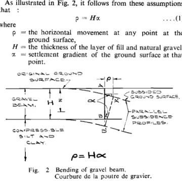
.... (1)
p=Hrx.
2 Bending of gravel beam. Courbure de la poutre de gravier. Fig.
where
(e) plane sections at right angles to the ground surface before consolidation remain plane during the settlement.
As illustrated in Fig. 2, it follows from these assumptions that
CO ....1PQ.S5S \ 'a'_E.
e,1L-"l セ ...c=J Cl- ...,·
Figure 3 shows the curve of horizontal movement along a typical east-west column line computed by equation (I) together with profiles of the vertical settlement and the thickness of the gravel layer. For comparison purposes the curve of horizontal movements obtained by actual measur-ements along this column line is also shown.
The accuracy with which the measured and the computed horizontal movement curves ha ve been determined has been limited by the following factors :
(i) the thickness of the gravel has been estimated by interpolation between test holes at about 600 ft. spacing;
(ii) the measured movements were obtained by a survey of the distances between building elements and do not account for any shearing strain which may have occurred between the building foundations and the underlying soil. Actual movements of the ground surface, unrestrained by the inherent rigidity of the buildings, could be greater but not less than the measured movements shown;
(iii) the curve of measured horizontal movements has
been plotted on the basis that the point of maximum settlement was a point of zero horizontal movement. Unfortunately it has not been possible to verify this assumption by survey, because there is no fixed baseline from which to establish the original position of the buildings.
p = the horizontal movement at any point at the ground surface,
H = the thickness of the layer of fill and natural gravel,
o: = settlement gradient of the ground surface at that point.
Discussion
A compariso n of the curves of measured and computed horizontal movement shows a similarity in shape as illus-trated by the typical curves shown in Fig. 3. Although there are individual areas of inconsistency, the average overall agreement is reasonably close.
It will be noted that while equation (I) is derived on the assumption that plane sections at right angles to the ground surface before consolidation remain plane during the settl-ment it is not assumed that the soil follows Hooke's law, nor that it is homogeneous and isotropic. The equation expresses a purely geometric relationship. The complexity of shortening over certain portions and stretching over others.
This indicated that the plane on which the foundations rested was being warped with some areas being deformed in tension and others in compression.
The available data suggested that the horizontal movements were in some way related to the vertical settlements. Because future vertical settlements of appreciable magnitude were expected to continue for several years, it was important to obtain a better understanding of the relationship between horizontal movements, vertical settlements, and building distortions. The fact that the structural deformations from the horizontal movements appeared to be as severe as those from the differential vertical settlements made this particu-larly so.
Analysis of Horizontal Movements
An estimate of the lateral consolidation to be expected due to horizontal components of the major principal stresses had revealed that such movements would be small in magnitude compared to the measured horizontal shortening and that they would occur in an outward direction away from the centre of the loaded area. Thus the observed shortening could not be accounted for directly on this basis. Other factors therefore appeared to be governing the observed horizontal movements.
Horizontal movements associated with subsidence due to mining and to oil and water pumping operations, including both stretching and shortening, have been reported in several instances. These have the common characteristic that the seat of important settlement was located below the base of relatively incompressible strata. (HURST 1948, KING and SMITH 1954, LocKWOOD 1954, SHOEMAKER and THORLEY 1955, HENRY 1956, GIBSON 1957, PERZ 1957, RELLENSMANN 1957, BERBOWER 1959). They are caused by the fact that the strata resting on the seat of settlement perform in a general way like a stiff elastic plate resting on yielding substrata. The stiff upper layers deform in such a way that the horizontal movement is directed toward the point of maximum settl-ement which is a point of zero horizontal movsettl-ement. The similarity in conditions and observed movements at Kitimat suggested that the same process was occurring there. When the measured horizontal and vertical movements of any east-west column line in the plant were examined, assuming zero horizontal movement at the point of maximum settle-ment, a relationship became apparent which was characteristic of that observed with other reported cases of horizontal movement due to subsidence.
Determination of the horizontal surface movements caused by subsidence does not lend itself to rigorous mathematical analysis because this involves the use of physical properties of the rock and soil for which there is inadequate knowledge. In the problem at Kitimat there is the further difficulty that the thickness of the stiff top stratum is variable. However, a simple expression giving approximate values for the hori-zontal movements at the Kitimat site has been obtained
based on the following simplifying assumptions :
(a) the contact surface between the upper gravel layer and the underlying compressible materials is well defined at a depth H below the surface, H being equal to the combined thickness of fill and natural gravel at any point;
(b) the horizontal displacements at all points along the base of the stiff gravel layer are zero;
(c) the subsidence curve at depth H is parallel to that at the surface;
(d) the layer of fill and natural gravel deforms to match the settlement pattern due to consolidation in the underlying compressible soils in such a way that no cracks occur within the soil mass which do not originate at the surface;
.1
____ Measured---MOVEMENT-- - - - -SETTLEMENT PROFILE n'?0ve»rre n". HORI20NT""L I' D/rec.f/on
セMMMMMM
Sh o r r e n l n . ; ? - - - . I - - - . sIreI c l 7 i 7-""-,
COn?puヲセ、 (f=1-10<.):;'''''''' ,/⦅MMGセBG]BGZZZZZ⦅Z]⦅MセZZNZZZセZNZZZZZセM Jis
Tセ iMMzセ Zwf-°L W 0.5 l'iWw r1>1l ooセ I L - - f - - - 00 JZw
\サRセ v f-f=Ww 2..0aJw
Wf- lL >I-v uJ Jl 4-.0セ
POint' 01 ma':in?i/m sell/ement'e'ii/a/s polnr or a s s con ea: zero
horiZonraI n7overnenf. Ifi JI- wI-Zw :iW vl.. - J :t f-0 0
"
'C=- o"
0 0 0 0 0 c>"
0 0 0 0 H 0 0 0 <> 0 0 0 GRAVEL <:> 0 c» 0"
r
100 0 0 0 0 <) 0 c> 1200 F'EET 'Z...coFig. 3 Thickness of gravel, settlement profile, computed and measured horizontal movements along an E-W column line. Epaisseur du gravier, coupe du tassement, mouvements horizontaux sur une ligne de colonnes Est-Ouest, calcules et mesures.
Acknowledgments
The smelter is owned by the Aluminum Company of Canada, Limited and the authors have acted as Consultants to the owners on the settlement problems encountered at the site. The data are presented with the approval of the of factors involved and the accuracy with which the known factors can be defined do not warrant a more refined analysis. A similar relationship can be obtained by considering the behavior of the gravel to be analogous to that of a bending beam. Itwas in fact this concept which first lead the authors to the development of the relationship for the horizontal movements. Trials were made to correlate the measured displacements with horizontal movements computed on this basis, for cases of the neutral surface being located at various positions above the base of the gravel layer by using the expression :
wherezis some constant fraction of H. The best correlation was obtained for the case ofz = H, i.e., for conditions as expressed
by equation (I).
It is not unreasonable however, to expect the neutral surface to be located near the bottom of the gravel, if one considers that the modulus of deformation for granular materials increases approximately in direct proportion to the depth.
While it is recognized that this simple geometrical expression represents only an approximation of the actual movements, and that the degree of agreement with the actual movements may be less in the ultimate picture than at present, neverthe-less equation(I)has been used at this site as a basis for estima-ting the nature of future horizontal movements which are likely to develop as the vertical settlement continues. It is anticipated that the future movements which develop will provide additional information on the relationship between vertical and corresponding horizontal movements.
p
= zo: .... (2)Company, which has been very co-operative in undertaking the expenditures necessary to secure the information essential for these studies. The major portion of these studies was done by the junior author as part of a graduate thesis project done in the Department of Civil Engineering at the University of Alberta under the direction of the senior authors.
References
[l] BERBOWER, R. F., A. M. ASCE, (1959). Subsidence Problems in the Long Beach Harbor District. Paper 2068,Journal
of the Waterways and Harbors Division, Proceedings
of the American Society of Civil Engineers, vol. 85, No. WW2.
[2] GIBSON, DONALD, (1957). Buildings without Foundations, A Lecture on the Problems of Building on Moving Ground. The Journal of the Royal Institute of British
Architects, vol. 65, No.2, pp. 47 to 59.
[3] HARDY, R. M. and RIPLEY, CHARLES F., (1954). Founda-tion InvestigaFounda-tion for the Kitimat Smeller.The
Engineer-ing Journal, vol. 37, No. II, pp. 1460-1466.
[4] HENRY, F.D.C, (1956). The Design and Construction of
Engineering Foundations,see Chapter 9, pp. 392 to 412,
McGraw-Hill.
[5] HURST, G., (1948). Avoiding Subsidence Effects in Surface Buildings Colliery Engineering, vol. 25, pp. 158-163, 194-198, 230-234.
[6] KING, H. J., and SMITH, H. G., (1954). Surface Movements due to Mining,Colliery Engineering, vol. 31, pp. 322-329.
[7] LOCKWOOD, MASON, G., (1954). Ground Subsides in the Houston Area. Civil Engineering, vol. 24, pp. 370-372. [8] PERZ, F., (1957). Mathematical Relationships, and Sub-sidence Troughs. Mine and Quarry Engineering, vol. 23, No.6, pp. 256-260.
[9] RELLENSMANN, O'rro, (1957). Rock Mechanics in Regard to Static Loading caused by Mining Excavation.Quarterly
of the Colorado School of Mines ..Behaviour of Materials
in the Earth's Crust, vol. 52, NO.3.
[10] SHOEMAKER, R. R. and THORLEY, T S., (1955). Problems in Ground Subsidence. Journal American Waterworks
Association,vol. 47, pp. 412-418.