• Aucun résultat trouvé

Methodology for flood resilience assessment in urban environments and mitigation strategy development

N/A
N/A
Protected

Academic year: 2021

Partager "Methodology for flood resilience assessment in urban environments and mitigation strategy development"

Copied!
230
0
0

Texte intégral

(1)

HAL Id: tel-01159935

https://tel.archives-ouvertes.fr/tel-01159935

Submitted on 4 Jun 2015

HAL is a multi-disciplinary open access

archive for the deposit and dissemination of sci-entific research documents, whether they are

pub-L’archive ouverte pluridisciplinaire HAL, est destinée au dépôt et à la diffusion de documents scientifiques de niveau recherche, publiés ou non,

environments and mitigation strategy development

Jelena Batica

To cite this version:

Jelena Batica. Methodology for flood resilience assessment in urban environments and mitigation strat-egy development. Other. Université Nice Sophia Antipolis, 2015. English. �NNT : 2015NICE4006�. �tel-01159935�

(2)

ECOLE DOCTORALE STIC

SCIENCES ET TECHNOLOGIES DE L’INFORMATION ET DE LA COMMUNICATION

T H E S E

pourl‟obtention du grade de

Docteur en Sciences

del‟Université de Nice-Sophia Antipolis

Mention:Automatique, Traitement du Signal et des Images présentée et soutenue par

Jelena BATICA

Methodology for Flood Resilience Assessment in Urban Environments and Mitigation Strategy Development

Thèsedirigée par Philippe GOURBESVILLE soutenue le 19 mars 2015

Jury:

M.Manuel GOMEZ VALENTIN, Professeur UPC-Barcelone, Spain Rapporteur

M. David BUTLER, Professeur-University of Exeter, United Kingdom Rapporteur

M. Ole MARK, Danish Hydraulic Institute, Denmark Examinateur

M. Philippe Audra, Professeur-Polytech Nice Sophia/Université Nice Sophia Antipolis Examinateur

M.Antonio Parodi, University of Genoa/International Center for Environmental Monitoring Examinateur

(3)
(4)

I am very glad that I had a possibility to do a thesis on flood resilience in urban environments. I enjoined working on my PhD thesis for many reasons. Some of them are working with master students that are coming from countries all around the world. I could hear their expression on different flood hazard, different protection levels available in their countries, about decision-making processes. Second thing, I was able to travel and meet many people working on the same subject and exchange experiences and findings.

I would like to thank those who supported and assisted me during my PhD research. In the first place I would like to thank my promoter and supervisor Professor Philippe Gourbesville. Starting from the scratch was not very easy and our discussions and his willingness to listen and to read many lines of chapters helped me to finalize the thesis. Thank you for the critical review of my findings.

Also, I would like to express my thanks to the thesis committee members for their interest to read and give feedback.

I am expressing my thanks to academic staff within engineering school, Polytech Nice-Sophia, for creating good environment for my doctoral studies.

I had an advantage to start working on my thesis as a member of an international team of scientists under EU FP7 project CORFU. Being in this kind of scientific and professional hub pushed me forward new findings and conclusions. I would like to express my gratitude to project coordinator Professor Slobodan Djordjevic. I would like to thank the project partners who supported me and help me test the methods I developed.

Finally, this dissertation is dedicated to my family, my daughter Sofija and my husband Vladimir. In two months, I will become mom for the second time. Thank you for unconditional support and patience during these years. With you everything makes sense.

(5)
(6)

Méthodologie pour l'évaluation de la résilience urbaine face aux crues et dévéloppement des stratégies de prévention

RÉSUMÉ

Inondations qui se produisent dans les zones urbaines sont régies par une fréquence accrue. Structures de protection contre les inondations existantes démontrent ses inconvénients. Une des solutions est émouvant de culture du risque et de trouver l'équilibre entre la forme de l'utilisation des terres et de l'urbanisation grâce à des stratégies d'adaptation, d'atténuation, de prévention et intervention et de rétablissement. La nouvelle approche globale est basée sur le concept de résilience donner une nouvelle place pour le développement et la mise en œuvre de nouvelles approches en vertu de gestion des risques d'inondation (FRM) cadres existants. Ajout de résilience à la gestion des risques d'inondation est une première étape. Grâce à une gestion des risques d'inondation opérationnelle a pour la résilience des prestations. L'indice résilience Flood (FRI) est développé dans cette thèse est une approche unique pour l'évaluation de la résistance aux inondations dans les systèmes urbains avec la priorité principale de la structure du système lorsque l'évaluation se fait sur les micro et méso échelle et sur la dimension du système lorsque la résistance aux inondations est évaluée sur macro échelle. La réflexion est mis sur le développement de la méthode par l'évaluation de la gestion des risques d'inondation existants (FRM) cadres. Grâce à l'évaluation, il est possible de constater le niveau d'intégration et de mise en œuvre de l'élément essentiel du risque d'inondation. La méthode développée pour l'évaluation de la résistance aux inondations est potentiellement applicable à tout système urbain à une échelle géographique. Connexions et dépendances entre éléments principaux de la ville et des risques naturels (dans ce processus d'inondations urbaines de cas) sont définis. Avec sa mise en œuvre, les relations politiques, sociales et culturelles, économiques entre les villes seront plus visibles et mieux établie et la gestion des risques d'inondation ainsi mis en œuvre.

(7)

Floods that happen in urban areas are governed by increased frequency. Existing flood defence structures demonstrate its downsides. One of the solutions is moving to risk culture and finding the balance between the shape of land use and urbanization through adaptation, mitigation, prevention, and response and recovery strategies.

While managing the flood risk in urban areas, the priority is to minimize flood damages. The new holistic approach is based on resilience concept. Adding resilience to flood risk management is a first step. Through operational flood risk management has as benefit resilience. The potential of implementing resilience in urban flood management can provide a increased cost-effective component. Decrease of flood damages expresses increase efficiency and cost effectiveness of applied solution. This brings adds additional performance to flood risk management. Multidisciplinary approach that is provided by the resilience concept join forces of technical (structural) and measures on economic, environmental, social and institutional level. If established, flood resilient communities have effective means to increase adaptation capacity regarding flooding processes.

The main reflection is on the development of method by evaluation of existing flood risk management (FRM) frameworks. Through evaluation, there is a possibility to notice the level of integration and implementation of crucial element of flood risk. As defined here the main elements (i) flood, (ii) vulnerability and (iii) exposure are the main elements. Using the evaluation principles the FRM framework is evaluated regarding achieved readiness level considering its elements, level of integration and implementation. If the readiness level is achieved the FRM can be developed in order to be moved towards resiliency.

The presented case studies in Europe and Asia all of different approaches and possibilities to evaluate resilience attributes as well as capacity of these urban systems regarding flooding processes. The differences in urban flooding problems in European and Asian cities vary from levels of economic development, infrastructure age, social systems and decision-making processes, to establish drainage methods, seasonality of rainfall patterns and climate change trends.

Assessing flood resilience involves in equation flood damage, risk perception and vulnerability analysis. A role of resilience in sustainable development becomes significant. Developed methodology analyses urban system through different scales and elements (urban city functions and services). The purpose is to minimize the flood damages if possible. In most of the causes damages driven by floods can be minimized if urban system: already have implemented some of

(8)

in this thesis differ in many ways. Differences in case study areas start form different institutional organization. The priority made in the existing FRM frameworks differs in Europe and Asia. The level of urbanization and level of available assets in the analyzed cities is not the same. This contributes to different level of disturbances made during and after flood and make reflection on flood resilience in urban systems.

A very important thing is existing risk culture among analyzed areas. The level of economic preparedness differs and it is noticeable that even there are available financial resources.

The developed method for evaluation of flood resilience is potentially applicable to any urban system on any geographic scale. Connections and dependences between main city elements and natural hazards (in this case urban flooding process) have to be defined. With its implementation, social, economical, political and cultural relations between cities will be more visible and better established. The approach should uncover the role of physical components of urban system and population in relation to urban flooding processes. A further strategy focuses on simulation of community losses and recovery measures. As a major challenge that faces urban systems nowadays, the research on resilience prioritizes in following years. A key recommendation proposes: improving resilience determines urban patterns, which are matching with optimal water distribution, waste collection, energy distribution etc.

The Flood Resilience Index (FRI) is developed as unique approach for evaluation of flood resilience in urban systems with the main priority on system structure when evaluation is done on micro and meso scale and on system dimension when flood resilience is evaluated on macro scale.

(9)

Contents

1 Introduction ... 20

1.1 Flooding and urban systems ... 21

1.2 Motivation for research ... 24

1.2.1 Thesis objective and research questions ... 25

1.2.2 Thesis outline ... 25

2 Resilience and flood risk management ... 27

2.1 Flood risk ... 28

2.2 Flood risk management and flood resilience ... 32

2.2.1 Vulnerability and urban flood resilience ... 32

2.2.2 Urban flood management and flood resilience ... 37

2.3 Approaches and frameworks for adapting to flood risk ... 39

2.4 The methodology for assessing flood risk management ... 48

2.4.1 The maturity levels ... 49

2.4.2 Discussion of results ... 57

2.4.3 Adding resilience to flood risk management ... 59

2.5 Conclusion ... 61

3 Flood resilience assessment ... 62

3.1 Urban systems: Scaling and mapping ... 63

3.1.1 Mapping of urban system - urban functions and city services ... 64

3.2 Systemic analysis of a city ... 71

3.2.1 FAST approach ... 71

(10)

3.3 Quantification of urban flood resilience ... 74

3.3.1 FRI at parcel/building level (micro and meso-scale) ... 74

3.3.2 FRI at block scale ... 83

3.3.3 Qualitative parameters - availability levels of urban function for FRI evaluation 86 3.3.4 Weights ... 88

3.3.5 Example ... 90

3.3.6 FRI for city/district scale ... 98

3.4 The roadmap for FRI assessment ... 103

3.5 Conclusion ... 104

4 Measures for increasing flood resilience of urban systems ... 107

4.1 Introduction ... 108

4.1.1 Flood mitigation and adaptation capacity development ... 109

4.1.2 Components of resilience and timing frame for resilience measures ... 111

4.1.3 Elaboration on flood resilience measures ... 112

4.1.4 Flood resilience and resistance measures for city services ... 126

4.2 Mitigation measures (block and parcel/building level) ... 127

4.3 Conclusion ... 133

5 Application and results ... 136

5.1 Implementation ... 137

5.2 Nice case study ... 140

5.2.1 Hydraulic modelling ... 141

(11)

5.2.3 FRI evaluation process ... 146

5.2.4 FRI evaluation for City/urban scale - Nice ... 148

5.2.5 Summary of the results ... 150

5.3 Hamburg ... 153

5.3.1 Hydraulic modelling ... 154

5.3.2 Damage assessment ... 156

5.3.3 FRI Evaluation process utilizing the Flood Resilience Index (FRI) ... 158

5.3.4 Summary of Results ... 160

5.4 Beijing ... 163

5.4.1 Hydraulic modelling ... 163

5.4.2 Damage assessment ... 165

5.4.3 FRI Evaluation process utilizing the Flood Resilience Index (FRI) ... 167

5.4.4 Summary of results ... 169

5.5 Barcelona ... 170

5.5.1 Hydraulic modelling ... 170

5.5.2 Damage assessment ... 172

5.5.3 FRI Evaluation process utilizing the Flood Resilience Index (FRI) ... 174

5.5.1 Summary of results ... 176

5.6 Taipei case study ... 179

5.6.1 Hydraulic modelling ... 179

5.6.2 Damage assessment ... 181

5.6.3 FRI Evaluation process utilizing the Flood Resilience Index (FRI) ... 183

(12)

5.7 Conclusion ... 188

6 Discussion, conclusions and recommendations ... 190

6.1 Assessment ... 191

6.1.1 Specific objective 1 ... 191

6.1.2 Specific objective 2 ... 192

6.1.3 Specific objective 3 ... 192

6.2 Recommendations ... 193

6.2.1 FRI – limitation, future development and improvement ... 195

6.2.2 Sensitivity analysis ... 197

6.2.3 Final conclusion ... 198

7 Annexes ... 200

Table of Figures

Figure 1: Presentation of flood risk management concept ... 23

Figure 2: Resilience concept ... 24

Figure 3: Risk Management Cycle (source: Integral Risk Management Cycle, FOCP 2003) ... 40

Figure 4: Integrated flood risk management (WMO, 2009) ... 42

Figure 5 : EU administrative framework for managing flood risk ... 42

Figure 6: Flood management cycle with 3P‟s and E and R, (2007/60/EC) approach ... 45

Figure 7: Flood risk management cycle with 4A‟s, (FIAC2005) approach ... 46

Figure 8: Flood risk management cycle with The „four capacities‟ approach used in the Netherland ... 47

(13)

Figure 10: Theoretical curve for different maturity levels - adapted from (Batica, Goubesville,

Tessier, 2013) ... 52

Figure 11: Results from maturity matrix for case study cities (Batica, Goubesville, Tessier, 2013) 57 Figure 12: Elements for flood risk management cycle – CORFU project ... 59

Figure 13: City system represented through scales (city, district, block and parcel) ... 64

Figure 14: City system represented through scales (city, district, block and parcel), example of scaling applied on Nice case study, France ... 66

Figure 15: Mapping of the city according to urban functions and services ... 67

Figure 16: Mapping the urban system - Urban functions and city services, example on the city of Nice, France ... 71

Figure 17: Methodology for assessing flood resilient individual house ... 73

Figure 18: FRI for a block scale with two cases: flooded and no flooded block ... 85

Figure 19: Case study boundary, Nice, FRANCE ... 90

Figure 20: Comparison of different FRI values for flooded and non-flooded urban functions ... 93

Figure 21: Difference in FRI of flooded and non-flooded urban functions ... 94

Figure 22: FRI dynamics with respect to different flood depth for Nice case study ... 94

Figure 23: FRI evaluated for BAU on property/building scale, Nice case study ... 95

Figure 24: FRI evaluated for S1 scenario on building scale, Nice case study ... 96

Figure 25: Schematic presentation of FRI evaluation of city/district scale ... 99

Figure 26: Number of indicators per dimension for large scales ... 99

Figure 27: The roadmap for FRI assessment ... 104

Figure 28: Strategic scheme – structural measures ... 109

(14)

Figure 30: Example of flood map, case study Nice, France ... 114

Figure 31: Example of web-based platform for capacity building of human resources ... 115

Figure 32: Dry proofing and wet proofing for building (example) ... 118

Figure 33: Different flood types with respect to flood duration ... 129

Figure 34: Implementation of measures with respect to flood depth ... 132

Figure 35: Measures on block scale ... 132

Figure 36: General scheme for FRI assessment ... 139

Figure 37: The city of Nice in France. ... 140

Figure 38: Flood map for 100 year return period, Nice, France. ... 142

Figure 39: Depth damage curves for buildings, Nice, France ... 143

Figure 40: Direct flood damages per urban function ... 144

Figure 41: Calculated flood damage for Nice case study for 100 year return period ... 146

Figure 42: Weight percentage in each dimension (city/urban scale), Nice case study, France . 148 Figure 43: FRI presentation for different scenarios - city scale, Nice case study, France ... 152

Figure 44: Summary of the main parameters characterizing the Wandse cathcment area ... 153

Figure 45: Change in flow depth and inundated areas of a 100 year flood event The results are illustrated for a highly urbanised (Wandsbecker Chausse), an urban-suburban (Ostend pond) and a suburban area (Rahlstedt) ... 156

Figure 46: An example of a damage curve: multi-, duplex-, detached, medium resistance (1948) from the ground floor (residential, and public buildings) ... 157

Figure 47:Spatial distribution of specific damage (€/m²) for a 100 year flood event on the basis of the present scenario (year 2010); The results are illustrated for the focus areas: a highly urbanised (1-3), an urban-suburban (4-6) and a suburban area (7-9) ... 157

Figure 48: Comparison of all scenarios‟ overall FRIs per dimension ... 162

(15)

Figure 50: Spatial distribution of inundation for (a) 10-, (b) 20-, (c) 50-, and (d) 100-year return period events with current rainfall intensity ... 164 Figure 51: Building land use spatial distribution ... 165 Figure 5-52 UK Depth-damage curves ... 165 Figure 53: Building damage results of (a)10, (b)20, (c)50, and (d)100 year return period of rainfall events ... 166 Figure 54: Relationship of flood damage versus design storm frequency Indirect tangible impacts ... 167 Figure 55: Comparison of all scenarios‟ overall FRI's per dimension ... 169 Figure 56: The location of Raval District in downtown Barcelona. ... 170 Figure 57: Flood depths inside the parcels of the Raval District for rain events with return period of 1 year (left), 10 years (center) and 100 years (right) for the Baseline scenario ... 171 Figure 58: Land-use classes in the Raval district, the main land-use class of the ground floor is shown at a block scale ... 172 Figure 59: Depth damage curves for the buildings (left) and content (right) taking into account the local conditions of the Raval district. ... 173 Figure 60: Flood damages in the Raval district for a rain event of return period of 1 year (left), 10 years (centre) and 100 years (right). ... 174 Figure 61 Comparison of the FRI values per dimension ... 178 Figure 62: Digital Elevation Model, river system, and administrative districts in Taipei City . 179 Figure 63: Flood modelling results of the A1B scenario in the CTA ... 180 Figure 64: Land zonings in Taipei City. ... 181 Figure 65: Depth-damage curves for residential, commercial, industrial and cultural zones in Taipei City (Wang 2003). ... 182 Figure 66: Pluvial flood damage in the CTA of 100 year return period under the baseline scenario. ... 183

(16)

Figure 67: Graphical FRI presentation for Taipei case study ... 187

Figure 68: Stakeholder involvement in decision-making process ... 194

Figure 69: Evolution of flood resilience curve in theory ... 196

Table of tables

Table 1: Vertical scale for risk minimizing, France flood risk management as example ... 31

Table 2: Existing resilience approaches ... 35

Table 3: Flood resilience measures ... 38

Table 4: Comparing the frameworks for managing flood risks in the EU ... 47

Table 5: Maturity levels of flood risk management at city scale (Batica, Goubesville, Tessier, 2013) ... 50

Table 6: Evaluation principles ... 53

Table 7: Maturity levels for existing flood management frameworks in European and Asian case studies ... 56

Table 8: Dependency levels for city services with respect to different scales ... 70

Table 9: Critical requirements for urban functions ... 75

Table 10: Critical requirements for building ... 78

Table 11: A critical requirements at the property level ... 81

Table 12: FRI evaluation at property scale ... 82

Table 13: Critical requirements of block scale ... 84

Table 14: Description for the availability levels of each critical requirement (property/block scale) ... 86

Table 15: Weights for FRI (parcel scale) ... 88

(17)

Table 17: FRI values for different flooded urban functions considering different flood depths in

Nice case study area ... 92

Table 18: FRI values for different un-flooded urban functions considering different flood depths in Nice case study area ... 93

Table 19: Scales for Flood Resilience Index ... 100

Table 20: FRI evaluation for macro scale ... 100

Table 21: Dimensions within the urban system with the area of influence ... 101

Table 22: FRM elements in the FRI evaluation at city scale ... 102

Table 23: Strategic scheme – resilience measures ... 110

Table 24: Comparison table for the flood resilience measures with respect to different system dimensions and spatial scales ... 124

Table 25: Proposed flood mitigation strategies for analyzed case study areas in Europe and Asia (city scale) ... 125

Table 26: Flood types in case study areas ... 127

Table 27: Three main groups of measures at parcel/building scale ... 129

Table 28: Measures listed with respect to different flood depth ... 130

Table 29: Flood resilience and resistance measures on block scale ... 131

Table 30: Flood resilience and resistance measures on parcel/building scale (urban function) 133 Table 31: Statistics of flood damages ... 144

Table 32: Flood damage in Euro (€) ... 145

Table 33: Summarized scenarios and measures for the Nice case study. ... 147

Table 34: Overall FRI for the city/urban scale, Nice case study – current state scenario ... 148

Table 35: Overall FRI for scenarios, Nice case study ... 149

Table 36: Scenarios FRI breakdown per dimension and change (Δ) with respect to current state, Nice case study ... 150

(18)

Table 37: FRI values for different scenarios and different scales, Nice case study ... 150

Table 38: Scenarios considered for Hamburg case study ... 154

Table 39: Damage at a flood event of a certain probability p and annual expected damage (AED) for the Wandse catchment based on the reference land use- present state ... 158

Table 40: Overall FRI for the catchment scale of the Wandse, Hamburg case study ... 159

Table 41: FRI for all scenarios and their respective percentage of change in comparison to present state, Hamburg case study ... 159

Table 42: Scenarios FRI breakdown per dimension and change (Δ) with respect to present state, Hamburg cases tudy ... 160

Table 43: General results for all scales ... 161

Table 44: Flood damage and rainfall statistics for different return periods ... 166

Table 45: Scenarios for Beijing case study ... 168

Table 46: FRI for present state, Yizhuang, Beijing China ... 168

Table 47: FRI for 2050 state, Yizhuang, Beijing China ... 168

Table 48: Damages and probabilities for the three synthetic rain events simulated. ... 174

Table 49: Scenarios for Barcelona case study ... 175

Table 50Assessment of the FRI in the Raval district for the current state scenario (2050) ... 176

Table 51Assessment of the FRI of the adaptation scenarios in the Raval district ... 176

Table 5-52 Average expected annual damage assessment in CTA ... 182

Table 53: Scenarios for Taipei case study ... 184

Table 54: The indicators of FRI are considered for baseline scenario, Taipei case study ... 185

Table 55: FRI for the city/district scale of Taipei case study ... 185

Table 56: FRI values for all scenarios and the percentage of change with respect to baseline scenario in comparison. ... 186

(19)

Table 57: FRI for the city/district scale of Taipei case study ... 186

Table 58: Assessment of the FRI by “Evaluator #1” in the Raval district, Barcelona ... 197

Table 59: Assessment of the FRI by “Evaluator #2” in the Raval district, Barcelona ... 197

(20)
(21)
(22)

1.1 Flooding and urban systems

Floods that happen in urban areas are governed by increased frequency (Ouarda et al., 200;, Gaume, et al., 2010; Villarini, et al., 2009; Schmocker-Fackel & Naef, 2010; Greenbaum et al., 2010; Prudhomme et al., 2003; Kusumastuti et al., 2008). Existing flood defence structures demonstrate its downsides. That signifies that primary protection regarding flood is not sustainable anymore. The solution is moving to risk culture and finding the balance between the shape of land use and urbanization through adaptation, mitigation, prevention, and response and recovery strategies.

There are different approaches in solving problems connected to urban flooding in Europe and Asia. Existing case studies in Europe and Asia provide a respectful example of different approaches and possibilities to evaluate resilience attributes as well as capacity of these urban systems regarding flooding processes. The differences in urban flooding problems in European and Asian cities vary from levels of economic development, infrastructure age, social systems and decision-making processes, to establish drainage methods, seasonality of rainfall patterns and climate change trends.

Sensitivity analysis of urban systems implies a deeper investigation of urban flooding, condition of the built environment, way of mapping built environment, its interaction with nature and vulnerability evaluation. Further to that, a resilience approach to solve and assess the sensitivity of urban systems in respect to flooding becomes crucial.

Urban flooding is no longer just a natural phenomenon. The social component of urban system is contributing to the increasing trend of urban flooding. Urban spaces are facing the flood risks, nowadays. The flooding processes are now presenting the risk related phenomena. This is influenced by natural conditions, undeveloped disaster culture of urban communities, etc. The expanded urban spaces give broader exposure to flood risk and new forms of flood damage. Especially during the last century, the drastic changes were made to river environments. Natural drainage systems are mainly forced into artificial channels in favour to impervious areas. Furthermore the structural measures were more dominant. In addition to that, local communities have a declining trend in terms of considering, activities linked to awareness and disaster prevention. Accordingly, the urban flooding becomes not only the engineering problem but also calls for attention of key stakeholders. As one of the most frequent hazard on earth flooding processes, pose a significant damage to population and the urban environment.

(23)

In order to minimize the causes that flooding processes pose to urban environments the resilience concept becomes a new driving approach for assessing sustainability of urban systems. Reducing and minimizing causes become challenging. In this light adaptation actions are unavoidable. The importance of adaptation is in reducing future costs.

The traditional approaches promote the struggle against the water through implementation of structural measures while resilience approach underlines "flood friendly" approach through implementation of non-structural measures, which are more adaptable to increased flood frequency.

The impervious areas are contributing to bigger pressure on existing urban drainage networks due to a greater percentage of precipitation episodes. The produced runoff cannot be fully accommodated only by drainage network and as a result, urban flooding is unavoidable. Furthermore, climate change may cause flooding to occur more frequently and be more severe in urban areas (IPCC, 2008).

Resilience approach divides responsibility to governmental and community level regarding urban flood risk management. It also considers the resilience of a population to floods that can be measured with time. Assessment of resilience that focuses on population following a bottom-up approach starting from individuals and then assessing community level. Building resilience involves also contribution of social networks, increasing response capacity of communities, self-organization, learning and education and cheering adaptive culture. Measures for improving social side of resilience covers: raising public awareness, implementation of flood forecasting and warning, emergency response planning and training, sharing information, education and communication. As significant is also flood insurance, damage and causalities report, damage assessment facilitating claim procession, reconstruction, charity funds, social therapeutic measures, disaster recovery plans and financial assistance after a flood. Measures are incorporated in the flood management cycle. It differs from country to country but the basis is covering all three stages regarding the flood, stage before, during and stage after the flood. The role of strategies is to prevent flood damage and to save lives.

Let us start defining flood risk management approach. In this thesis flood risk management (FRM) is defined as a set of all activities that enable case study area to cope with flooding processes. The strategies under FRM should enable proper functioning of the case study during and after flooding.

(24)

Resilience on the other side is defined as a system property to cope with disturbances up to the level where the functionality of complete urban system is not jeopardized. In order to make the concept more tangible the resilience concept needs to be quantified. This was done with indicators developed to provide insight of systems resilience level flood event.

Since flood occurrence in urban systems is not a new event there are many strategies in current flood management plans with very little differences.

Introducing resilience takes into account different aspects of urban environment. As stated, structural measures cannot avoid disasters and therefore resilience approach stand as one of the solution for decreasing flood damages. Nowadays extreme events have underlined vulnerability of modern societies and unpreparedness. Of course, there is a need for reviewing an existing protection approaches. For sure, the protection is not the only way since 100% protection will never be achieved. This comes from the fact the protection structures are limited with the design period.

Figure 1: Presentation of flood risk management concept

The focus is on the magnitude of event on side and level of damage and impact on the other side. The representation is done in the figure above. Based on the event curve the protection measures do have influence up to the design level. However, the area above the protection line is

Magnitude of event

Dama

ges and

impact

(25)

adaptation and carrying capacity up to the level where impact and damage will be tolerable for the urban environment. The resilience concept on the would have presentation as presented in figure below.

Figure 2: Resilience concept

In Figure 2 the presentation is done for resilience concept with respect to magnitude of event and damages. As presented, through resilience introduction within FRM the level of damages is reduced and relaxed. This means that urban system can tolerate bigger damages and bigger magnitudes of event. Also it is important to mention that resilience has positive and negative character. In some cases, the application of resilience strategies at currently resistant system can be costly. To conclude, the change towards more resilience or more resistant system depend the most of social system and like that defers from system to system.

1.2 Motivation for research

In recent years the direct as well indirect damages caused by floods are higher ans the floods have the higher frequency (Berz, 2001;Parker, 2000; Susman et al., 1983; Takeuchi, 2002). With the increased urbanisation, change in land use there is a lake of ability to cope and the traditional flood risk management (FRM) with existing tools do not have a right response to the change.

Magnitude of event Dama ges and impact Protection measures Resileince

(26)

In addition, the new tools are necessary in order to include urban planners, sociologist, urban geographers and engineers to sit together to contribute to the decision making process. Having in mind that the decision on local level is in hands of city mayor and it is not necessary that he have knowledge of natural hazard management.

The development in technology as a consequence of wider range of possible measures that can be implemented.

The research for this thesis started from the findings and conclusion of Rajib Saw (2009) and his interpretation of Climate Disaster Resilience Index (CRDI). The basis of his research and latter on application on world cities establishes on analysis of a whole city area through five dimensions (eg natural, physical, economic, social, institutional). Within dimensions the set of indicators are used to present the current level of resilience to various disasters: volcano, flood, hurricane, earthquake, and tsunami.

1.2.1

Thesis objective and research questions

The general objective is to demonstrate applicability of developed methods: (i) maturity of FRM frameworks and (ii) Flood Resilience Index (FRI).

The research within thesis focuses on the following:

 Is there a methodology that can evaluate existing flood risk management taking into account different level of content within FRM and different implementation status?  How flood resilience of urban systems can be evaluated taking into account its

characteristics?

 What are differences in resilience between different urban systems?

1.2.2 Thesis outline

The thesis comprises seven chapters:

 Chapter 1 (current question) contains problem definition, introduction, motivation for research and research question definition

 Chapter 2 focuses on the connection between flood risk management and the resilience  Chapter 3 focuses on developed method for Flood Resilience Index (FRI) evaluation

(27)

 Chapter 4 analyze FRM and resilience measures, their classification in order to fit defined scales within urban system

 Chapter 5 focuses on application of FRI method on five European and Asian cities and obtained evaluation results

 Chapter 6 contains critical analysis of the develop method and the future steps of the flood resilience within FRM

(28)

2 Resilience and flood risk

management

Parts of this chapter has been published as:

Batica, Jelena, and Gourbesville, Philippe.: “Methodology for Flood Resileince Index”, 3rd IAHR Europe Congress, Book of Proceedings, Porto, Portugal, 2014

Batica, Jelena, Gourbesville, Philippe and Frank Tessier.: "Methodology for maturity of flood risk management frameworks assessment – application to Asian and European

(29)

2.1 Flood risk

In recent years, a distinctive rainfall pattern and quantity rainfall results in a greater volume of flood discharge along with a higher peak discharge than before. Furthermore, the number of heavy rainfall‟s, the primary external force of a flood hazard, has been in increase in urban areas in Europe and especially in Asian countries. Consequently, if this trend continues, it might become a major factor in increasing the flood risk in urban areas.

In addition, another factor that increases flood risk is occurring in the floodplains. Flood risk characterizes diversion and complexion. Flooding as a phenomenon that includes runoff, precipitation, flood wave propagation, flood damage that changes over time and have variations form region to region. Influenced with natural conditions, more often with human activities and non-sufficient disaster culture flooding represent risk –related phenomena. New flood risks are emerging in urban areas. This is in addition to extended urban spaces, bigger exposure to flood risk and new forms of flood damages.

Over the last century, the drastic changes have broth to river environments. Rivers forced into artificial channels brings less natural and more artificial environment. In addition to that, local communities have declined trend in considering activities linked to awareness and disaster prevention. Urban flooding is not anymore just a natural phenomenon. The social conditions play an important role and they have spatial and temporal variation. Increasing precipitation episodes that cities are experiencing today due to a big percentage of impervious areas imposes huge pressure to existing urban drainage system. In most cases, drainage network is able to accompany produced run-off.

Properties of precipitation (scale, pattern, distribution in time and in space) are major factors that determinate the magnitude and characteristics of flood as a hazard. Urban flooding brings a risk to an urban system. Its fundamental to have proper understanding of urban flood risks and to be familiar with the components that construct risk. This should be looked as follows; risk implies that some extreme event (in this case flood) caused by natural force or by a combination of natural and human forces. This defines a first component or flood risk. The second component is represented through vulnerability.

(30)

Figure 1: Risk definition

Vulnerability represents a notion that someone or something that is at risk. In other words, somebody or something is vulnerable to a hazard (flood) or is in the flood pathway. Term vulnerability in defining flood risk does not separate physical exposure to flood on one side of vulnerability of persons or assets to flood on the other side. This is crucial during analysis and decision regarding possible measures and their effectiveness in reducing risk. As a third component, that defines flood risk stand exposure. Within this term, the exposure is in direct connection with increase trend of urban flood damages. This triggers increased population and assets physically exposed to floods in urban systems. The most common situation related to unplanned extension of urban space in favour to limited inundation areas.

Risk minimizing with implementation of strategies engage implementation in vertical and horizontal scale.

Horizontal scale focuses on the available measures. Strategies for urban flood management include structural and non-structural mitigation measures that take into consideration climate-change variability, including climate-changes in the frequency and intensity of tropical cyclones.

Non-structural measures should include strengthening legislation for urban flood management including coastal management, institutional coordination and cooperation, improvement in investment monitoring, capacity building and the decentralization of resources from national to local levels. “Risk-sensitive” land-use planning holds useful practices and strategies for managing river basins and water resources comprehensively. Risk sensitivity in planning can help in controlling exposure to hazards, including the impacts of upstream development on downstream areas.

(31)

The vertical scale includes institutional responsibility from national to municipal level. Looking at the institutional division in the European Union and taking France as an example structure is presented on the table below.

Authorities in horizontal scale on European Union example defined through river basin management authorities, responsible for implementation of the Water Framework Directive (WFD) (2000/60/EC Directive) and the Flood Risk Directive (FRD) (2007/60/EC Directive), and disaster planning and crises response authorities, with specific responsibilities in disaster planning and response during flood events.

(32)

Table 1: Vertical scale for risk minimizing, France flood risk management as example

LEVEL FLOOD MANAGEMENT

European

POLICY

Flood risk management: Flood prevention, protection and mitigation Trans European Networks (TEN) (http://www.unece.org/)

LAW

Water Framework Directive (WFD) (http://ec.europa.eu) OTHER PLANNING INSTRUMENTS

ICPR (IKSR) (http://www.iksr.org)

National

LAW

Law on Natural Disasters (Loi relative aux catastrophes naturelles), (http://www.legifrance.gouv.fr)

Law on security, protection of forests against fire and prevention of major risks, (Loi relative à la sécurité, à la protection de la forêt contre l‟incendie et

à la prevention des risques majeurs), (http://www.legifrance.gouv.fr) Water Policy, (Loi sur l‟eau), (http://legifrance.gouv.fr)

Law on the prevention of natural and technological hazards, (Loi relative à la prévention des risqué naturels et technologiques),

(http://www.legifrance.gouv.fr)

Legislation transposing the Water Framework Directive (WFD), (Loi portant transposition de la directive cadre sur l‟eau (WFD)),

(http://www.legifrance.gouv.fr)

Regional

POLICY

Master Plan development and Water management SDAGE/SAGE (Schéma Directeur d‟Aménagement et de gestion de l‟eau SDAGE / SAGE),

(http://www.eaufrance.fr)

Flood zone Atlas (Atlas des zones inondables), (http://www.rdbrmc-travaux.com)

Management and Flood prevention Plans (Plan d‟Aménagement et de Prévention des Inondations (PAPI)),

(http://www.driee.ile-de-france.developpement-durable.gouv.fr)

Department

POLICY

Plan for prevention of foreseeable natural risks of inundation (Plan de prevention des risqué naturels previsibles d‟inundation PPRI) (http://www.alpes-maritimes.equipement-agriculture.gouv.fr)

Inter-municipal POLICY

River contract (Contrat de rivières), (http://www.eaufrance.fr)

(33)

2.2 Flood risk management and flood

resilience

Managing the flood risk in urban areas, the priority is to minimize damages caused by flood. Operational flood risk management has as benefit resilience. The potential of implementing resilience in urban flood management can provide a cost-effective component. Efficiency and cost effectiveness is in both, decrease flood damage away from existing structural measures and add additional performance to flood risk management. Multidisciplinary approach that is provided by the resilience concept join forces of technical (structural) measures and measures on economic, environmental, social and institutional level. If established, flood resilient communities have effective means to increase adaptation capacity regarding flooding processes. Despite the fact that local authorities have not yet acknowledge the concept of resilience and its implementing some of the resilience measures are fully or partly implemented in recent flood risk management approaches. That proves that implementation of resilience concept and introduction of resilience into existing flood risk management plans and strategies is realistic. Implementation of resilience is through three dimensions. Resilience relevant measures consider (i) interplay of institutions, (ii) communication regarding flood risk and (iii) development and implementation of flood modelling tools. All three of them considers as very important.

The resilience of communities to flood risks corresponds to our capability to deal with flood risk by means of integrated management of flood, exposure, and damage. Local communities, governments and residents (as individuals) may reduce the existing flood risk by implementing measures that are able to prevent certain events from occurring. Measures of this type influence of the runoff in catchment‟s, help the concentration of runoff in river channels, reducing exposure to flooding processes and reducing vulnerability and application of measures through mitigation processes.

New risks that are emerged with structural measures for example with the creation of embankments the inundation zones are becoming more favourable.

2.2.1 Vulnerability and urban flood resilience

Within disaster research, community the concept of vulnerability is widely used. However, due to the change of urban environment the understanding of vulnerability changed too. Many definitions of vulnerability at present define hazard exposure of social component of urban

(34)

system. By social component, the population with specific social character is understood. Some of definitions of vulnerability refer to climate change (IPCC, 2008) some refer to environmental hazard (Klein and Nicholls, 1999) and some for flood vulnerability (Veen & Logtmeijer 2005, Connor & Hiroki, 2005, Balica et al., 2009, UNDRO, 1982, McCarthy et al., 2001). General conclusion is that vulnerability is a context of risk (Gabor and Griffith, 1980)

Looking from ecological aspect resilience defines as the ability of a system to absorb changes of variables and parameters, and still persevere (Burton, 1983) Ecological resilience focuses on systems far from any equilibrium steady state, where the system could turn over into another regime of behaviour. In other words, the system from an ecological point of view doesn‟t need to define the conditions which will provide some functionality. On the other hand, urban systems need to have in advance defined „conditions‟ in order to have the proper level of functioning.

When considering urban resilience the ability of system potentially exposed to hazard to resist, respond, recover and reflect up to a stage which is enough to preserve level of functioning and structure is underlined. The Urban system can be resilient to lots of different hazards. Here, one of the focuses will be flood resilience of urban systems. Urban resilience defines the the degree to which cities are able to tolerate some disturbance before reorganizing around a new set of structures and processes.

Two elements describe urban system: the build environment and population. Physical characteristic of the built environment and social characteristic of the population are to be examined in order to evaluate resilience of urban systems. The focal point of this paper is flood resilience of urban systems. Resilience of urban systems relates to adaptation of land use to flood processes. Urban system over decades change and it continues to change existing land use to satisfy the needs of residents, e.g. increased impervious areas. In order to have a high level of protection for residents the strategies and measures are developed and implemented. However, awareness to preserve natural drainage paths in urban systems was not a priority.

With urban development and increase of vulnerability, communities have to move to risk culture and to be able to accept a certain level of flooding but with decreased flood damages. Reshaping of build environment therefore stands as a one of the solution for decreasing flood damages. According to urban geography, a systemic approach considers a city, as a complex system required numerous regulations to keep it stable. These regulations enable, at all times, to re-establish urban functions after the disturbance of external events such as natural hazard. In this

(35)

light, flood risk could be considered as one of the elements, which activate regeneration of urban systems. In this perspective, urban risk is not only a threat to the city and its inhabitants, but also one of the essential components of urban structure and the evolution of its urbanisation. For that reason, it is necessary to analyze flooding processes in the context of urban spatial development. The development of methodology and analysis of urban systems through different scales and components can provide essential information for the transformation of the urban spatial organization.

This approach has three concepts that describe and assess flood risk in urban systems (city): carrying capacity, vulnerability and resilience (Burton, 1983).

The concept of (i) carrying capacity identifies the maximum tolerable damage that a community or a city could bear.

 The concepts of (ii) vulnerability and (iii) resilience serve to measure and to assess the carrying capacity of a community or a city. The vulnerability is to express the impact of disturbance of a system; the resilience describes the capacity of a system to absorb the shock.

In this perspective, it is necessary to develop a new methodology of urban diagnostic facing urban flood risk issue. A possible approach is based on the development of urban flood vulnerability and resilience assessment tools with indicators enables to provide a comprehensive overview of vulnerability and resilience of a city or a community. For the purpose of evaluation of urban risk, the urban structure is composed of three main components: building with its function, infrastructure and surface.

Trying to look for a sustainable solution in solving flooding problems in urban areas, the definition of vulnerability and resilience to flooding processes are important. Although vulnerability is often used in a conjunction with resilience, the meaning is following;

Vulnerability is defined as the conditions determined with physical, social, economic, or environmental factors or processes, which are increasing the weakness of community to the impact of hazard (UN/ISDR, 2004). Resilience, on the other hand, represents the capacity of an urban system or community exposed to hazard to adapt by resisting or changing in order to reach an acceptable level of functioning, organization and structure (UN/ISDR, 2004).

(36)

The defined terminology of vulnerability and resilience is very important in the analysis of urban areas and their existing flood risks but there should be a distinction between the flood vulnerability and flood resilience of people on one side and the urban structure on the other side. Resilience doesn‟t have a general definition although it is increasingly used in integrated urban drainage management, (Ashley et al., 2007; De Bruijn 2004; Klein et al., 1998; Sayers et al., 2003; Sendzimir et al., 2007; Vis et al., 2003;). The term resilience is often left open to debate. The diverse interpretations of resilience reflect the complexity of this concept and made it „difficult‟ in implementation of integrated urban drainage management. Accordingly, it implies that the definition of what is vulnerable and what is building the resilience should be clear. Initial understanding of the various definitions that are nowadays present with its determinants is significant. Broader view of existing resilience approaches is described in table below.

Table 2: Existing resilience approaches

According to Walker at all., 2004 resilience is defined as the ability of a system to absorb disturbance and to reorganize up to the level of changes that allows the same function, structure, characteristics and feedback. If ecosystem resilience is taken into consideration the first part of the definition is fulfilled in the sense that ecosystem will accept disturbance by the level that allows persistence.

In social resilience for example the definition, by Adger (2000), relates to the ability of human communities to tolerate to external stress to services and mechanisms that ensure health care, education, community progress, profit distribution, employment and social welfare.

Properties of a system that relates to being persistent, robust to disturbance are not only one to be fulfilled in order to have resilient system. The disturbance brings beside shocks also an opportunity in the sense that the system is recombining and evolving its structure, create new

Resilience concept Characteristic Focus on Context

Engineering Return time, efficiency Recovery, constancy Proximity of a stable equilibrium Ecological/ecosyste m resilience Buffer capacity, withstand shock, maintain function Persistence, robustness Multiple equilibrium, stability landscapes Social/ecological system resilience Interplay disturbance and reorganization, sustaining and developing Adaptive capacity, transformability, learning innovation Integrated system feedback, cross scale dynamic interactions

(37)

trajectories, renew itself, etc.. Consequently, resilience provides adaptive capacity that brings the continuous development of system interplaying among development and sustaining the changes. In this case balance between development and sustaining change is needed in order to avoid collapse.

Disturbance in the system depends on system reorganization possibilities. This process has spatial and temporal scale. Therefore the resilience concept brings adaptation, learning and self-organization in addition to the general ability to persist interruption.

In opposite to general resilience, specified resilience – resilience “of what to what” (Carpenter

et al., 2001) – is more concrete and open to the evaluation.

It can be defined by identifying what system attributes are to be resilient, and to what kind of disturbances. Specified resilience in the context of integrated urban drainage management (IUDM) has often been defined in a restricted sense to express the ability of the whole system to recover from the reaction of flood waves (Klein et al., 1998; Sayers et al., 2003; De Bruijn, 2004).

However, recent definitions of general resilience also make adaptability a property of resilience that reflects the system‟s ability to cope and constantly develop with changes and trends.

From this wide sense, the concept provides a perhaps more suitable background framework to develop and assess integrated approaches to urban drainage management.

Resilience is therefore specified here in respect to the broader social–ecological context as the capacity of the whole-system to absorb flood waves in annual variability, and to reorganize while undergoing change in flood wave frequency and severity in the long term, to enable it to function normally.

From this perception, the resilience approach is aiming to prevent the urban system as whole to move to undesirable state from which is not possible to recover due to extreme flood impact, etc. These preventions are in following directions:

 Adjusting the thresholds of a system in respect to changes in response to flood waves

 Defining the level to which system is capable of self organizing

 Define the level to which system is able to build and increase capacity for learning and adaptation

(38)

This defines the resilience thinking, a different point of view for guiding and organizing of urban systems.

2.2.2

Urban flood management and flood resilience

The measures listed under flood resilience are related to strong intent to increase capacity building of human resources, better land use management, increased flood preparedness and emergency measures that are taken during mostly usually and after flood event. The lists of measures are presented in Table 3 (bellow).

Capacity building of human resources refers to increasing awareness of flood risk among key stakeholders in urban system. The awareness among population is assessed through presenting the brochures, short public presentations, creating internet portals that with useful information‟s. Constant communication with population and education are also one of elements for capacity building of human resources. The contribution to the capacity building of human resources comes also from the face-to-face learning activities and training. In existing urban systems, the measures are in developing stage since there is an absence of its consideration within traditional flood risk management.

Land use management refers to spatial planning and building regulations in order to create more space for water. The new buildings comes up with improved shapes that are able to accept certain amount of flood water and have minimal flood damage. The land use management contributes prevention to flood where possible. Adapting to flooding by floatable building and buildings on piles, dry and wet proofing of buildings contribute to increased flood preparedness and contributes to mitigate the effects of flood. The measures that refer to preparation to flooding processes are financial preparedness, voluntaries, shelter management, improving flood insurance schemes, evacuation and rescue plans, etc. During the flood event, these measures are tested.

(39)

Table 3: Flood resilience measures

Capacity building of human resources

Flood maps (Inundation and Risk)

Info material (brochures, public presentations, internet portals

etc Education - Communication Face-to-face learning Web-based learning Training Collaborative platforms

Land use control Spatial Planning

Flood risk adapted land use Building regulations

Building codes Zoning ordinances Flood preparedness Flood Resistant buildings

Wet-proofing Dry-proofing

Flood action plan (local scale) Infrastructure maintenance Contingency

measures

Financial Preparedness Insurance of residual risk

Reserve funds Emergency Response: Evacuation and rescue plans

Forecasting and warning services

Control Emergency Operations Providence of emergency response staff Emergency infrastructure Allocation of temporary containment structures Telecommunications network Transportation and evacuation

facilities

Recovery – disaster recovery plans, pecuniary provisions of

(40)

2.3 Approaches and frameworks for adapting

to flood risk

The flood risk management in most Asian countries is often considered under the umbrella of disaster risk management planning (ADPC, 2005). The focus is mainly on emergency response and relief activities but the damages and huge flood damages and loses to physical environment and human population caused with floods are changing the existing approach regarding risk management. The shift in the approach in managing disasters in Asia is recognized within the global initiative of the International Strategy for Disaster Reduction (ISDR). The approach brings knowledge that disasters cannot be prevented, disasters can be reduced. The focus is on flood risk reduction through risk assessment and developing and applying strategies to manage flood risk. The risk reduction activities that are aimed at mitigating flood risk and preparing people for floods are highlighted. Integrated flood risk management provides a holistic way of addressing flood risk with respect to the cooperation of stakeholders and ensuring that all phases in the disaster risk cycle are covered.

With respect to European Water Framework Directive (2000/60/EC) for flood management, the flood risk is the likelihood of a flood event along with its adverse consequences, including the loss of human life, damage to the environment, and economic impacts through reduction in activity.

From the same perspective, the flood risk can be considered as a threat, and the source of flood hazard. Further, the quantification of flood risk results in either monetary units or the potential loss of life, if the losses are quantifiable or in qualitative terms in the case of intangible damages (cultural, environmental, etc).

(41)

Figure 3: Risk Management Cycle (source: Integral Risk Management Cycle, FOCP 2003)

The framework for flood risk management begins with the definition of „flood risk‟. There is no single definition for flood risk but the one that is very useful to start from says that flood risk is unity of hazard, exposure and vulnerability. These three components determine flood risk. Hazard is defined as the potential for harm, loss or damage. In the case of flood risk, it is the threatening natural event including its magnitude and probability of occurrence. Hazard exists where land is liable to flooding. Hazard increases with probability, with flood depth, and with flow velocity.

The second component is exposure to hazard. Even where a hazard exists, there is no risk unless there are assets or people that can be damaged. The exposure to flood hazard creates the potential for personal danger or property damage to property.

The risk also depends on how vulnerable people and assets are in danger of damage. Vulnerability is defined as the characteristics and circumstances of a community, system or asset that make it susceptible to the damaging effects of a hazard (UN/ISDR, 2004). Vulnerability is a lack - or loss - of resistance to damaging forces that are coming from a threat (hazard). Flood vulnerability can be minimized by taking actions before flooding and knowledge of what action to take in order to minimize damage and receive adequate warnings and actions during and after flood event.

Further, the basis and structure of FRM frameworks is in line with temporal scales starting before the onset of the event and continue through up to the recovery phase. This is a crucial

(42)

element of the risk management cycle. With this concept the systematic identification, assessment and prioritization of associated risks are covered. Further, the management of measures for risk mitigation, individual phases of prevention, response, preparedness and recovery are also included. Figure 3 contains presentation of different stages in the risk management cycle. The delineation between these phases is not always clear-cut.

Accordingly comprehensive flood risk management has to consider all three components: hazard, exposure and vulnerability. In addition, the focus should be also on the environment and community, which gives it a strategic characteristic. . Strategic flood risk management considers physical and social components of the urban environment. Consequently, it covers:

 The institutional and legal framework;  Implementation of strategies;

 Social and environmental assessment.

Flood risk management aims to reduce the impact of flooding and one of most effective approaches is through developing risk management programs that incorporate the prevention or reduction of flood damage.

Flood risk management aims to be proactive and that requires the following steps:

 Risk identification;

Development of strategies to reduce risk;

Creation of policies and programs to implement strategies.

The integrated flood management approach (World Meteorological Organization, (IFM 2009) is based on the principle of reducing vulnerability throughout building resilience and developing a culture of prevention. This is done through preparedness rather than by reactive responses alone. The decisions are made as a part of the ongoing science-based process. This involves processes that plan, act, monitor and evaluate applied strategies. The new knowledge is then available and incorporated into management approaches. This represents a shift from traditional management, and rather views management actions as learning experiments. Integrated flood management (IFM 2009) has five stages:

 Adopting a basin approach to flood management;

(43)

 Reducing vulnerability and risks due to flooding;  Addressing climate vulnerability and change;  Enabling community participation.

Figure 4: Integrated flood risk management (WMO, 2009)

Elements of integrated flood risk management are presented on figure below. This approach promotes integrated instead of a fragmented approach to managing flood risk, and aims to maximize the efficient use of floodplains and to minimize loss of life.

Figure 5: EU administrative framework for managing flood risk EU level

National level

Municipal

EU Water Framework Directive - EUWFD EU Flood Directive - EUFD

River Basin Management Plan - RBMP Sub-basin management plans

Flood Risk Management Plans - FRMP

Flood maps

Local protection plans

Special Urban planning procedure

Increasin

g level o

(44)

The Water Framework Directive (2000/60/EC) focuses on achieving good qualitative and quantitative statuses of water bodies in the European Union. The Floods Directive (2007/60/EC) is focused on managing the flood risk in member states and minimizing the consequences of flooding. Each member state should undertake a preliminary flood risk assessment for each river basin district, following the articles in the Flood Directive. This preliminary assessment means the production of appropriate maps for river basins, records of past floods, existing studies of future floods, and the collection or creation of records regarding human, economic and heritage losses. This preliminary assessment creates a base for a production of flood hazard and flood risk maps. The flood risk and hazard maps should be completed by December 2013. A further development is the creation of flood risk management plans for river basin districts focusing on prevention, protection, and preparedness measures, flood forecasting and early warning systems. One of the important steps regards informing the public and providing consultation. This is set within Article 9 of the Flood Directive. This is in addition to updating and reviewing the produced flood risk management plans.

2.3.1 River Basin Management Plans (RBMP)

Plans are required by the EU Flood Directive by December 2015. Integrated River Basin Management plans are dedicated to harmonizing conflicting interests, complexity and uncertainty. Regarding floods, the main goal of these plans is to achieve the coordination of actions in the different parts of the catchment in addition to ensure protection, improvement and sustainable use of all water resources in each major catchment of the European Union. The plans are recording the current status of water bodies within the river basin districts, setting out the measures planned to meet objectives and act as the main reporting mechanism to the European parliament and to the public.

2.3.2 Flood Risk Management Plans (FRMP)

The recent events recorded in Europe have underlined the need to integrate and unify all actions related to flood risk management. In order to gather under the umbrella of flood risk management the prevention, the protection and the preparedness actions, a new legal framework was needed. This action was achieved with the introduction of Flood Risk Management Plans (FRMP). This was motivated by the flood events that occurred from 1998 to 2009 in Europe. During this period, more than two hundred floods occurred. The most devastating were floods along the Danube and Elbe rivers in summer 2002. During a period of 11 years (from 1998 to

(45)

2009) floods caused 1126 deaths, the displacement of 500 000 people and at least €52 billion of economic losses. Also the floods that occurred in 2005 reinforced the need for intensive action. Flood Risk Management Plans therefore are expected to provide all information regarding flood risk on the level of the river basin district. These plans present a legal instrument for flood risk management. Plans consider all types of flooding and focus is on five main pillars:

 Preparedness;  Prevention;  Protection;

Emergency response;  Recovery measures.

Flood risk management plans have a role to point out to policy makers, developers and the public the nature of risk and the measures proposed to manage the risks.

There is a wide range of existing frameworks that can be used as a guide to manage flood risk covering prevention, coping and recovery from flooding. These include the „4As‟ planned by the Scottish Government, the Floods Directive defines „3Ps an E and an R‟, and „4 capacities‟ proposed in the Netherlands.

3P’s and E and R (2007/60/EC)

This approach focuses on Prevention, Protection, Preparedness, Emergency response and Recovery (the aforementioned 3Ps and E and an R). These elements contribute to the effective flood risk management program. Prevention is focused on preventing damages caused by flooding processes. This is done by avoiding future development in flood prone areas, adapting the future development of the risk of flooding and the promotion of appropriate land-use, agricultural and forestry practices. Structural and non-structural measures are focused under the protection part of the „3P‟s an E and an R‟ strategy. Measures are reducing the likelihood of flooding and the impact of flooding at the specific location. Preparedness is oriented to informing the population about flood risks and about actions that are to be taken during the flood event. Further, the emergency response tends to develop emergency response plans in the case of flooding. The final part, recovery and lessons learned, cover the set of actions taken to return to normal conditions. Mitigating both the social and economic impacts is important here.

Figure

Table 7: Maturity levels for existing flood management frameworks in European and Asian case  studies  Beijing  (China)  Barcelona (Spain)  Hamburg  (Germany)  Nice  (France)  Taipei  (Taiwan)  FLOOD HAZARD
Figure 14:  City system represented through scales (city, district, block and parcel), example  of scaling applied on Nice case study, France
Figure 15:  Mapping of the city according to urban functions and services
Table 8: Dependency levels for city services with respect to different scales
+7

Références

Documents relatifs

The C++ platform proposes a framework in which stochastic or determin- istic discrete dynamic models can be implemented, and several efficient methods for sensitivity

For water matrix, a high frequency of quantification (~100%) was observed in rivers and lakes for all targeted parabens.. The level of concentration was as follow: ethylparaben

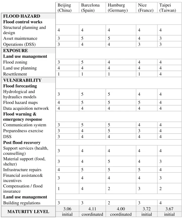
To find appropriate measures and to bring them in an order, a numerical calculation is necessary. Table 3 provides an overview of the proposed evaluation scheme to asses

Unit´e de recherche INRIA Lorraine, Technopˆole de Nancy-Brabois, Campus scientifique, ` NANCY 615 rue du Jardin Botanique, BP 101, 54600 VILLERS LES Unit´e de recherche INRIA

Abstract: We present in this report a library to compute with Taylor models, a technique extending interval arithmetic to reduce decorrelation and to solve differ- ential

A partir d’un premier mod`ele th´eorique d’optimisation topologique pour la conception des circuits magn´etiques pour propulseurs ´electriques, nous avons d´evelopp´e une

DWELLING UNIT type: area (sq m): tenure: LAND/LOT utilization: area (sq m): tenure: DWELLING location: type: number of floors: utilization: physical state: DWELLING

The objective of this paper is to study the reliability of assessment by analyzing the effects of several influencing factors: number of test locations used to identify a