3D stochastic modeling of karst aquifers
using a pseudo-genetic methodology
thesis presented at the
Faculty of Sciences
Institute of Hydrogeology and Geothermics
(CHYN)
University of Neuchˆ
atel, Switzerland
for the degree of
Doctor of natural sciences
presented by
Andrea Borghi
accepted on the recommendation of Prof. Philippe Renard Prof. Guillaume Caumon
Prof. Philip Brunner Prof. Fabien Cornaton Dr Pierre-Yves Jeannin
Arnaud Levannier
•
U11
1e
UNIVERSITÉ DE
NEUCHÂTEL
Faculté des sciences Secrétariat-décanat de Faculté Rue Emile-Argand 11 2000 Neuchâtel -Suisse Tél:+ 41 (0)32 718 2100 E-mail: [email protected]
IMPRIMATUR P
·
OUR THESE DE DOCTORAT
La Faculté des science
s d
e l'Université de Neuchâtel
autorise l'impression de l
a
présente thèse soutenue par
Monsieur Andrea BORGHI
Titre: 3D stochastic modeling of karst aquifers using a
pseudo-genetic methodology
sur le rapport des membres du jury:
•
Prof. Philippe Renard
,
Université de Neuchâtel
,
directeur de thèse
•
Prof. Philip Brunner
,
Université de Neuchâtel
•
Prof. Guillaume Gaumon
,
Université de Lorraine
,
France
•
Prof. Dr Fabien Cornaton
,
WASY-DHI
,
Berlin
,
Allemagne
•
Dr Pierre-Yves Jeannin
,
ISSKA
,
La Chaux-de-Fonds
,
Suisse
Neuchâtel
,
le 9 avril 2013
Le Doyen
,
Prof
.
P
.
Kropf
Tous les compl´ements de temps, sans pr´eposition, qui indiquent la dur´ee et la r´ep´etition, sont `a l’accusatif. Merci `a feu Prof. Eric Roth, pour cette r`egle de grammaire Allemande que je n’oublierai probablement jamais, ainsi que pour le reste.
Contents
Acknowledgments 3
Abstract 9
Extended Abstract 13
1 Introduction 15
1.1 Motivations and state of the research . . . 17
1.2 Goal of the thesis . . . 19
1.3 Structure of the thesis . . . 19
2 Conceptual model and study site 21 2.1 Introduction and conceptual model . . . 23
2.2 Description of the site . . . 24
2.2.1 Regional situation . . . 24
2.2.2 Geographical situation . . . 25
2.2.3 Geological settings . . . 25
2.2.4 Hydrogeological settings . . . 26
2.2.5 Available hydrogeological data . . . 29
2.3 Geological modeling . . . 32
2.3.1 Model limit and local coordinate system . . . 32
2.3.2 Modeled stratigraphy . . . 32
2.3.3 Model construction . . . 34
2.4 Conclusion . . . 35
3 Stochastic fracture generation 37 3.1 Introduction . . . 39
3.1.1 Terminology convention used in this chapter . . . 39
3.2 Methodology . . . 40
3.2.1 Implicit geological model . . . 40
3.2.2 Using the UFM model for fracture length distribution . . . 41
3.2.3 Consideration and integration of field data in the proposed approach . . . 43
3.2.4 Construction of the initial set of fractures . . . 44
3.2.5 Placement and rotation of the fractures . . . 47
3.2.6 Discretization of the fractures in a regular grid . . . 48
3.3 Examples of application . . . 49
3.3.1 Synthetic case . . . 50
3.3.2 Application to the Valley of les Ponts-de-Martel . . . 50
3.4 Discussion and perspectives . . . 50
3.5 Conclusions . . . 52
4 A pseudo-genetic stochastic model to generate karstic networks 55 4.1 Introduction . . . 57
4.2 Overview of the approach . . . 58
4.2.1 Regional Geology modeling . . . 59
viii Contents
4.2.3 Hydrodynamic control . . . 61
4.2.4 Karst conduit simulation . . . 62
4.3 The proposed algorithm and its implementation . . . 62
4.3.1 3D geological model . . . 62
4.3.2 Internal structure of the carbonates . . . 63
4.3.3 Hydrogeological analysis . . . 63
4.3.4 Karstic network modeling . . . 64
4.3.5 Stochasticity of the generated networks . . . 70
4.4 3D demonstrative examples . . . 71
4.4.1 Case 1, coastal aquifer . . . 71
4.4.2 Case 2, aquifer in folded tectonics . . . 71
4.5 Discussion . . . 73
4.6 Conclusions and outlooks . . . 76
5 Extensions and improvements of the pseudo genetic karst model 77 5.1 Introduction . . . 79
5.2 Description of the Fast Marching Algorithm . . . 79
5.2.1 Boundary value front propagation methods . . . 79
5.2.2 Fast marching methods . . . 80
5.3 SKS usage of the Fast Marching Algorithm . . . 81
5.3.1 Matlab programming language choice . . . 82
5.3.2 Regular grid to support the computation . . . 82
5.3.3 Walkers . . . 83
5.3.4 Speed function definition . . . 84
5.3.5 Impact of the inlet selection over the final shape of the network . . . 88
5.4 Forcing the conduits to go downstream . . . 94
5.5 Diverging conduits . . . 94
5.5.1 Spheric plugs . . . 96
5.5.2 Gaussian plugs . . . 96
5.5.3 Discussion . . . 97
5.6 Application to the Valley of les Ponts-de-Martel . . . 98
5.7 Consideration of geophysical data . . . 102
5.8 Conclusions . . . 105
6 Finite element flow simulation for karst aquifers 107 6.1 Introduction . . . 109
6.2 Overview of the existing models . . . 109
6.2.1 Black-box models . . . 109
6.2.2 Distributed parameters models . . . 110
6.2.3 Network modeling . . . 110
6.2.4 Recharge/epikarst model . . . 111
6.3 Methodology . . . 111
6.3.1 Modeling the karstic network by pseudo-genetic approach . . . 111
6.3.2 Meshing . . . 112
6.3.3 Hierarchy of the networks . . . 112
6.3.4 Recharge and epikarst model . . . 113
6.3.5 Boundary and initial conditions . . . 115
6.3.6 Model run workflow . . . 118
6.3.7 Simulating flow and transport by equivalent medium “karst” elements . . . 118
6.3.8 Simulating flow and transport in 1D pipes embedded in a 3D porous matrix . . . . 120
6.3.9 Transport simulation . . . 121
Contents ix
7 Framing the inverse problem for karst modeling 123
7.1 Introduction . . . 125
7.2 Investigation about the identifiable karst geometrical and physical properties from tracer test data . . . 125
7.2.1 Model description . . . 125
7.2.2 Geometrical karst realizations . . . 126
7.2.3 Flow parameters for each karst realization . . . 126
7.2.4 Reference simulation selection . . . 126
7.2.5 Inverse problem solving . . . 127
7.2.6 Statistical analysis of the error, switching the reference . . . 127
7.3 Possibility of acceleration of the search using PEST . . . 131
7.3.1 Model description . . . 132
7.3.2 Systematic search . . . 133
7.3.3 PEST optimization . . . 135
7.4 Conclusions and further outlooks . . . 137
8 Conclusions 139 8.1 Main results . . . 141
8.2 Further outlooks . . . 141
Bibliography 147
A Source code details 155
B Summary the tracer test done in the Valley of les Ponts-de-Martel 157
C A method for the stochastic modeling of karstic systems accounting for geophysical data: an example of application in the region of Tulum, Yucatan Peninsula (Mexico)161
3
Fran¸
cais
Je tiens `a remercier tout d’abord Prof. Philippe Renard, mon directeur de th`ese. Je n’aurais jamais fait une th`ese sans lui, j’en suis bien convaincu. Durant mon travail de master, il a su, par son intelligence, sa curiosit´e et sa sympathie, allumer la flamme de la recherche en moi. C’est aussi lui qui avait d´ej`a commenc´e `a discuter avec SWS d’une th`ese sur le karst, bien avant que je n’envisage la voie accad´emique, et qui a accept´e de me prendre sous son aile, `a la foi carburant (par ses id´ees) et gouvernail de ma recherche. Son amabilit´e est `a la fois sa plus grande qualit´e et sa mal´ediction; j’esp`ere qu’il saura conserver cette qualit´e tout en r´eussissant `a trouver des espaces pour poursuivre ses propres recherches, ou coder un truc g´enial par-ci par l`a. J’espr`ere aussi qu’il r´eussira `a profiter comme il se doit du bˆateau `
a voile dont il vient de devenir l’heureux propri´etaire. Bon vent mon capitaine ;)
Je tiens ensuite `a remercier Schlumberger Water Services (SWS) pour avoir financ´e cette th`ese, et en particulier tous ses membres qui m’ont suivi durant ces ann´ees. En tout premier je voudrais remercier Jean-Pierre Delhomme, qui a ´et´e int´eress´e par ce sujet d`es le d´ebut, et qui `a pouss´e pour que cette th`ese voie le jour. Je souhaite ensuite remercier Sandra Jenni, pour toute son ´energie, et pour les nombreuses suggestions au d´ebut de ma th`ese. La fatalit´e `a voulu que le groupe de SWS de Paris soit ferm´e, et que Sandra suive un autre chemin. Dans cette p´eriode de ”battement”, j’ai ´et´e suivi par Gilles Mathieu, que je remercie vivement pour son amabilit´e, et pour avoir trouv´e une solution qui me permette de terminer ma th`ese cette quatri`eme ann´ee avec un financement de SWS P´erou. Mon dernier remerciement du cˆot´e de SWS va `a Arnaud Levannier, mon dernier superviseur, qui a su valoriser grandment mon travail, en particulier le simulateur de conduits karstiques, apr`es la r´ealisation de la th`ese.
Merci `a Fabien Cornaton, pour les innombrables heures qu’il a pass´ees `a m’aider et pour sa disponi-bilit´e `a me laisser utiliser son code GROUNDWATER. Je n’oublierai jamais la premi`ere fois que, jeune ´
etudiant de master, j’ai ouvert la porte de son bureau pour lui poser une question, alors qu’il n’´etait pas forc´ement de sa meilleure humeur... J’ai depuis toujours conserv´e une forme de timidit´e subsonsciente quand il s’agissait d’aller l’embˆeter (de personne ou par e-mail) pour lui demander conseil.
Merci `a Jahouer Kerrou pour m’avoir souvent pass´ee des conseils bien utiles et sa disponibilit´e. Un grand merci aussi au Prof. Pierre Perrochet pour tous les conseils hydrodynamiques, et au Prof. Philip Brunner, pour les discussions sur le probl`eme inverse et pour ses innombrables relectures d’articles et morceaux de ma th`ese.
Je remercie aussi tous les autres collaborateurs du groupe stochastique. A Julien Straubhaar, en par-ticulier, un grand merci pour tous les conseils algorithmiques et sa patience. Sans lui mon apprentissages de certains m´eandres obscurs de la simulation et de la programmation auraient sans doute ´et´e beaucoup plus difficles.
Je remercie de tout coeur Damian Glenz, coll`egue et collocataire, pour les innombrables heures `a discuter nos difficult´es r´eciproques, et `a trouver ensemble des solutions (parfois peut-ˆetre pas totalement scientifiques). Je le remercie ´egalement pour toute son amiti´e, pour les longues nuits insomniaques pass´ees ensemble `a l’unimail, et pour avoir toujours su garder le sourire, en supportant mes exc`es d’humeur.
Je souhaite aussi remercier Pierre-Yves Jeannin, directeur de l’ISSKA, pour m’avoir accueilli dans son institut `a plusieurs reprises, ainsi que pour tous les conseils et critiques constructives qui ont grandement influenc´e ma th`ese. Merci aussi `a tous les collaborateurs de l’ISSKA pour leur amabilit´e et leur amiti´e.
Merci aussi au premier rapporteur de ma th`ese, Prof. Guillaume Caumon, pour ses commentaires et pour m’avoir offert un postdoc dans son institut, merci aussi `a Pauline Collon-Drouaillet pour ˆetre sur la mˆeme longueur d’onde que moi. J’esp`ere que notre collaboration future nous sera profitable `a tous.
Merci aux 4 ´etudiants de master qui ont eu la patience de me supporter en tant que superviseur: Guillaume de Scheppers, Cyb`ele Cholet, C´ecile Vuillleumier, et Louis Fournier. Ces 4 ´etudiants ont ´et´e les premiers (heureux) utilisateurs de mon code, et ont tous beaucoup contribu´e `a l’am´eliorer. Je les remercie beaucoup pour leur sympathie, leur sourire, et leur imprudence en m’acceptant en tant que superviseur. J’esp`ere sinc`erement qu’ils aient appris de moi autant que j’ai appris d’eux.
A Guillaume Pirot, qui sera pour moi toujours Guillaume Cravatte, un grand merci pour m’avoir support´e ces deux derni`eres ann´ees dans le bureau, et avoir su garder le sourire mˆeme en ayant pour voisin un ours brun comme moi.
Une th`ese dans une universit´e est une exp´erience scientifique et humaine avant tout. Je remercie sinc`erement tous les coll`egues et ´etudiants, pour leur amiti´e et leur pr´esence, pour les pauses caf´e, pour tous les bon mements pass´es ensemble. Je garderai toujours un bon souvenir des soupers et ap´eros au bord du lac, et j’en profite pour remercier de leur amiti´e bon nombre des ´etudiants avec qui j’ai eu l’occasion de trinquer (alors que ma th`ese ne m’avait pas encore totalement fagocit´e). Merci pour son
4 Acknowledgments
amiti´e et sa bonne humeur `a Mehdi Al-Zoubaidy, dont le charisme et la sympathie sont indiscutables, et qui a habit´e dans notre salon pendant les quelques mois de fin de son master (Il pourra d’ailleur passer r´ecup´erer sa brosse `a dents un jour). Merci au groupe des ”pintades”, `a savoir Lorienne Thueler, Ana¨ıs Eschbach, Sabrina Gonseth, et Chantal Crisinel, pour leur sympathie, les ap´eros, les sorties, et les pauses. Vous m’avez (sauf Lorienne bien sˆur) bien manqu´e ces 2 derni`eres ann´ees de th`ese.
Merci a Fran¸cois “Paco” Negro, derni`ere r´esistance de la g´eologie Neuchˆateloise, retranch´e dans son bureau du 3`e ´etage. Il a toujours su m’illuminer sur mes questions de g´eologie strucurale. Merci aussi pour toutes les discussions un peu geek sur les ´editeurs g´eologiques, en particulier Geomodeller3D®. Qu’il soit aussi remerci´e pour son aptitude `a animer les soir´ees des assitants, il restera dans ma m´emoire, comme celui qui personifie l’ˆame de la fˆete.
Merci aussi `a nos responsables informatiques: Gianni Gasparaotto, Romain Bessire et Eric de Car-valho. Nous avons toujours eu des discussions enrichissantes, et j’esp`ere avoir un peu contribu´e `a pr´esever leur nerfs durant certaines int´eractions entre le CHYN et le SITEL. Ils m’ont toujours aid´e `a trouver des solutions lorsque des prob`emes surgissaient, et toujours au plus vite.
Merci `a Manu, notre concierge, h´elas retrait´e. Si parfois il ´etait un peu distrait avec le nettoyage, il nettoyait toujours nos humeurs avec grand soin. Sa retraite a port´e un coup assez dur `a mon humeur, qu’il savait toujours am´eliorer quand il passait dans le bureau. Merci, ˆo concierge de l’humeur.
Merci infiniment aussi `a mes amis proches, `a mon clan pour ainsi dire: Anka Aubaret, Jean-Marc Buntschu, Daniel Burns, Patrick Oldendorf, Giovanni Dalle Nogare, Thomas D’Eysmond et Matteo Guggiari pour leur amiti´e durable, pour la confiance que j’ai en eux, et pour le soutient qu’il m’ont toujours apport´e.
J’ai bien peur qu’une page ne soit pas suffisante pour remercier aussi tous les autres. Je ne voudrais oublier personne dans ces remerciement, alors encore merci `a tous pour ces belles ann´ees de collaboration et d’amiti´e.
English
I would like to particularly thank the group of SWS Perou, and SWS Chile, for having funded my last year of research, and for having allowed me to test my methodology on one of their projects. In particular thanks to John Rupp and Lo¨ıc Ragas who followed this project, for their disponibility and kindliness. I also want to thank Wayne Hesh from SWS-software in Waterloo, for his interest in my code and all his suggestions.
Italiano
Devo ringraziare innanzitutto i miei famigliari, tutti quanti, per avermi sopportato (in tutti i sensi della parola) durante questa fase alquanto intensa della mia vita. In particolar modo grazie ai miei genitori, Marco e Gibi, per la loro infinita (ma proprio infinita, davvero) pazienza e mia sorella Angela per lo stesso motivo. Grazie a mia cugina Ninna per tutte le volte che mi ha sfamato durante i primi periodi della tesi, e per il suo affetto.
Un grazie ENORME alla mia compagna, Nora, per tutta la pazienza e amore che `e riuscita, e che riesce a darmi, anche nei miei periodi insopportabili e stressati. Spero di riuscire a darle tutta la felicit`a che lei d`a a me.
Infine, grazie ad Alessandro Comunian, mio primo coinquilino di ufficio (se si pu`o dire). I due anni in sua presenza sono stati veramente interessanti, e ha saputo trasmettermi un sacco di trucchi, la sua nerdaggine di Linux, e l’interesse per Python, per l’opensource, per la purezza del bash shell. Lo ringrazio anche per le innumerevoli serate all’uni, che sarebbero sembrate molto piu tetre senza la sua presenza.
5
Keywords
stochastic, karst modeling, inverse problem, flow and transport simulation, pseudo-genetic, Fast Marching Algorithm, fracture modeling, geological modeling
Parole chiavi
stocastico, modellizzazione di karst, problema inverso, simulazione di flussi e contaminanti, pseudo ge-netico, Fast Marching Algorithm, modellizzazione di fratturazione, modellizzazione geologica
Mots-cl´
e
stochastique, modelisation de karst, probleme inverse, simulation d’´ecoulement et transport, pseudo-genetique, Fast Marching Algorithm, modelisation de fractures, modelisation g´eologique
Stichworte
stochastisch, Modellierung von Karstaquiferen, inversen Ansatz, pseudogenetisch, Fast Marching Algo-rithm, Kluftmodellierung, geologisches Modell
9
English
The focus of this thesis is the development of a methodology to model karst aquifers. First the geometry of the karst conduits is simulated. Their geometry is controlled by the geology at large scale (geological model) and by the fracturation at smaller scale (stochastic model of fractures).
Secondly, these geometrical models (3D geological formation together with conduits) are used as base for flow and transport simulation.
Finally, the karst conduit generator called SKS (Stochastic Karst Simulator ) is coupled with the physical simulation (flow and transport) to investigate an inverse approach which allows to use this methodology in an uncertainty analysis.
The karst conduits simulation methodology is called pseudo genetic because it mimic the results of the speleogenetic processes, without simulating all the complex kinetic of karst systems genesis, like reactive transport, calcite dissolution and precipitation. In this approach, the karst conduits are simulated by approaching the physical principle of minimization of energy using a Fast Marching Algorithm. This algorithm allow to compute the minimum effort path, which is assumed to be the one used by water, and consequently the preferential dissolution.
Italiano
Lo scopo di questa tesi, `e lo svipuppo di una metodologia di modellizzazione realistica degli acquiferi carsici. Nella prima parte viene modellizzata la geometria dei condotti carsici. La geometria di questi ultimi, `e controllata a larga scala dalla geologia (modello geologico) e a piu piccola scala dalla fratturazione (modello di fratturazione stocastico).
In seguito questi modelli geometrici vengono usati come base per la simulazione di fluidi e trasporto di contaminanti. E infine, il simulatore di condotti carsici SKS (Stochastic Karst Simulator ) `e usato insieme alla simulazione di fluidi e trasporto per valutare l’applicabilit`a di un approcio inverso che permetta di utilizzare questa metodologia di simulazione.
La metodologia di simulazione dei condotti carsici `e detta “pseudo genetica”, perch`e tenta di approssi-mare la fisica complessa della speleogenesi (come il trasporto reattive, la dissoluzione/precipitazione della calcite) senza dover risolverla numericamente. In effetti si basa sul principio fisico della minimizzazione dell’energia, usando un algoritmo di Fast Marching per calcolare il cammino di minor resistenza (cio`e quello che dovrebbe seguire l’acqua). In pratica questa metodologia simula dei sistemi carsici maturi, direttamente nel loro stato finale.
Fran¸
cais
Le but de cette th`ese est le d´eveloppement d’une m´ethodologie de mod´elisation des aquif`eres karstiques. Premi`erement, la g´eom´etrie des conduits karstiques est simul´ee. La g´eom´etrie de ces conduits est contrˆol´ee `
a large ´echelle par la g´eologie (mod`ele g´eologique), et `a plus petite ´echelle par la fracturation (mod`ele stochastique de fracturation).
Deuxi`emement, ces mod`eles g´eom´etriques (formations 3D et conduits ensemble) sont utilis´es comme base pour la simulation d’´ecoulement et de transport.
En derni`ere partie, le simulateur de conduits SKS (Stochastic Karst Simulator ) est coupl´e avec la simulation d’´ecoulement et transport pour investiguer une approche inverse qui permette d’utiliser cette m´ethodologie dans une ´etude d’incertitude.
La m´ethodologie de simulation des conduits karstiques d´evelopp´ee ici se base sur une approche dite “pseudo-g´en´etique”, c`ad qui mime les r´esultats des processus de sp´el´eog´en`eses, sans pour autant simuler toute la dynamique complexe de ces processus, comme la dissolution et le transport r´eactif de calcite, etc. Dans cette approche pseudo-g´en´etique les conduits karstiques sont simul´es par une physique approch´ee, qui se base sur le principe de minimisation de l’´en´ergie. L’eau se d´eplace dans un milieu en cherchant le chemin de moindre r´esistance. Ce principe est utilis´e ici, par l’utilisation d’un algorithme de Fast Marching, qui permet de calculer le chemin de moindre effort.
10 Abstract
Deutsch
Das Ziel dieser Dissertation besteht in der Entwicklung einer Methode zur Modellierung von Karstaquiferen. In einem ersten Schritt wird die Geometrie des Karstsystems simuliert. Im grossen Massstab wird die Geometrie des Karstsystems durch die Geologie bestimmt (geologisches Modell), in kleinerem Massstab durch Kl¨ufte (stochastisches Modell zur Kluftgenese). In einem zweiten Schritt wird dieses Modell als Grundlage fr die Modellierung von Grundwasserstrmung und Stoffransport im Karstsystem verwendet.
Schliesslich wird die Simulation des Karstsystems mittels des Karst-Simulator (SKS, Stochastic Karst Simulator ) mit Simulationen von Grundwasserstrmung und Stoffransport gekoppelt, um einen inversen Ansatz zu untersuchen, der es erlauben wrde diese Methode im Rahmen einer Unsicherheitsanalyse zu verwenden.
Die hier entwickelte Methodik zur Simulierung von Karstaquiferen basiert auf einem sogenannt ”pseu-dogenetischen” Ansatz, weil sie speleogenetische Prozesse nachbildet, ohne die komplexe Dynamik dieser Prozesse, wie Aufl¨osung und reaktiver Transport von Kalzit etc., im Detail zu simulieren. Die Karstgenese wird in dieser Methodik vielmehr durch einen Ansatz angen¨ahert, der auf dem Prinzip der Energiem-inimierung beruht. Dabei wird ein Fast Marching Algorithmus verwendet, um zwischen den Stellen mit Wasserzufl¨ussen ins Karstsystem und den Karstquellen den Weg des geringsten Widerstandes zu berechnen.
13
Karst aquifers constitute an important source for drinking water, even though they are highly vul-nerable to contamination. Protecting karst water resources is in many ways challenging. The dissolution of calcite by infiltrating water produces preferential flow paths (conduit networks) within these aquifers. A key difficulty in understanding and protecting karst aquifers is that the temporal dynamics of karst systems are often dominated by these large conduits. However, the location of and structure of these dominant features are typically unknown, undermining quantitative, predictive approaches are inevitable for a solid risk management, the knowledge gaps on karst systems constitute a major impediment for a reliable protection of these critical resources. Stochastic approaches have proven their efficiency in uncertainty estimation in many other fields of application.
The present thesis proposes a new methodology to model karst aquifers, in a stochastic framework. The resulting models are consistent with the actual knowledge about these aquifers and their particular genesis processes (speleogenesis).
The proposed methodology is divided in several steps: first a geological model is built, to model the large scale geometry of the aquifer. Secondly the initial heterogeneities (inception horizons) of the aquifer formation are modeled stochastically, because they influence the small scale geometry of the conduits network. Then the stochastic conduit networks are simulated using the physical assumption that the water follows a minimum effort path while minimizing the total energy of a system. Finally, these models are used to simulate flow and transport. They can then be used in an inverse framework to estimate the uncertainty.
To build the geological model we use an already existing geological editor: Geomodeller3D®. This geological editor uses an implicit approach. The output of this kind of tools, provides on the one hand the information about the 3D localization of karstifiable formations, and on the other hand information about their orientation. This last information is used to generate stochastic Discrete Fracture Networks (DFN) with the following approach: the theoretical families of fractures that are expected in a folded environment are modeled with consistency with the local geological orientation. The fractures (simple rectangular planar objects) are first modeled in an unfolded environment, and then placed in the geological model and rotated according to the local orientation of the geology. We use the gradient of the geological potential field of the implicit geological model to retrieve the information about the geological orientation, and then to build a new vectorial base, which will be used as rotation matrix. The fracture number and size are distributed according to a power law as defined in the Universal Fracture Model (UFM) for the dense regime.
The stochastic conduit networks are modeled using the pseudo genetic methodology developed in this thesis: after the geological model, and the initial heterogeneities are built, a study of the regional hydrology / hydrogeology is conducted to identify the potential inlets and outlets of the system, the base levels and the possibility of having different phases of karstification. The conduits are then generated in an iterative manner using a fast marching algorithm. A probabilistic model can be used to represent the knowledge available and the remaining uncertainty depending on the data at hand. The conduits are assumed to follow minimum effort paths in the heterogeneous medium from sinkholes or dolines toward springs. The search of the shortest path is performed using a fast marching algorithm. This process can be iterative, allowing to account for the presence of already simulated conduits and to produce a hierarchical network. The final result is a stochastic ensemble of 3D karst reservoir models that are all constrained by the regional geology, the local heterogeneities, and the regional hydrogeological/hydrological conditions. Several levels of uncertainty can be considered (large scale geological structures, local heterogeneity, position of possible inlets and outlets, phases of karstification). Compared to other techniques, this method is fast, accounts for the main factors controlling the 3D geometry of the network, and can be conditioned to available field observations.
These networks are then used to simulate flow and transport with the finite element code GROUND-WATER. The conduits are meshed as pipe element that follow the edges of the 3D elements of the matrix. In the conduits, turbulent flow is simulated using the Manning-Strickler equations. The radius of the conduits is computed as a function of their hierarchical order. A lumped parameter model is used to model the recharge function. The flow boundary conditions that are used are: prescribed head [m] boundary conditions for the springs, prescribed nodal flux [m3/s] boundary conditions for the point inlets of the aquifer (dolines, sinkholes), and prescribed flux at element faces [m/s] boundary conditions or a source term [s−1] for the diffuse recharge. The diffuse recharge represent only a small percentage of the total recharge. The point recharge is distributed over all the inlets depending on their catchment area. Transport transient simulations are used to simulate the tracer tests. A standard workflow is used: first the head results of a flow steady state simulation are used as initial head for the transient long term
14 Extended Abstract
(years) flow simulation. Secondly, several transport simulations (their number depend on the number of tracer tests that have to be simulated) are run. Their initial head field is given by the outputs of the transient flow simulation. Their duration is short compared to the transient flow simulation (only several weeks, or months, depending on the rear tracer tests results).
The flow and transport simulations and the geometrical realizations can be combined in an inverse framework. Here the proposed inverse workflow is to produce many (hundreds) geometrical realizations (conduits networks), and then to optimize the flow parameters of each one and study the uncertainty on this base. In this thesis, two numerical tests have been done to estimate the feasibility of this framework. The goal of the first test is to investigate the possibility to retrieve physical and geometrical parameters using an inverse framework. A systematic analysis is made using 2D karst simulations. The conduits are represented by equivalent porous medium (EPM) cells crossed by a conduit of a given radius. 150 geometrical realization (150 pseudo-genetic models) have been generated. For each realization 120 possible combination of two physical parameters are systematically tested (radius of the conduits and matrix hydraulic conductivity). This ensemble of 18’000 simulations is then compared to a reference simulation to investigate the importance of including transport simulation (tracer tests) for the computation of the objective function φ. The results of this test show that including the transport results in the computation of φ can improve consistently the inverse results. To test the robustness of the approach, every simulation is successively used as reference simulation. This shows that in general good parameters are found. They also show that the parameter that is best characterized (with less uncertainty) is the conduit radius. The second test has been made with the aim of investigating the ability of a standard parameter estimation algorithm based on a Levenberg-Markquardt method to retrieve the good physical parameters of a realization. In this case, only transient flow is simulated. The results shows that this kind of algorithm can be used in this case, and that it allows to save a considerable CPU time in comparison with systematic search.
Chapter 1
Motivations and state of the research 17
1.1
Motivations and state of the research
Karst aquifers are a very important freshwater resource for mankind. Biondic et al. (1995) show that they provide 35% of Europe drinking water. According to Ford and Williams (2007) they cover about 25% of the total drinkable water of the world. In Switzerland, this correspond to around 18% of the drinking water supply and 66% of Canton Neuchˆatel (Spreafico and Weingartner, 2005). Karst aquifers are highly heterogeneous: they are composed on the one hand by low permeability limestone matrix, and on the other hand by highly conductive features created by the preferential dissolution of calcite (Ford and Williams, 2007) which are known as karst conduits and caves. These features may lead to geotechnical hazards especially in civil engineering, e.g. in tunneling or dam construction in karst regions (Milanovic, 2004). The conduit networks are very efficient in draining water, which leads to very high risks of pollution of spring water (Daly et al., 2002; Andreo et al., 2006). Most of the vulnerability assessment techniques used nowadays for the protection of karst system are based on GIS procedures (Ravbar, 2007). The current tools do not allow to consider the uncertainty (and consequently the risk neither) associated to karst aquifers. In a typical karst system, the matrix is assumed to have an important storage role, because it represents more than 90% of the total volume of these aquifers. The high permeability features represent a small total volume, but because they are highly interconnected they are responsible for more than 90% of the discharge of karst aquifers (Worthington et al., 2000). This highly conductive aspect can be problematic also in petroleum industry for paleo-karstic reservoirs (Corre, 1994).
The high permeability features in karst aquifers are produced by speleogenetic processes. Filipponi et al. (2009) have shown that that preferential flow paths do not occur randomly in the aquifer. They are very often initialized on inception horizons, which are preexisting discontinuities within the karstifiable formations, before the speleogenetical processes started. These discontinuities are usually particular bedding planes and fractures (Filipponi et al., 2009). The preferential dissolution of calcite along these horizons often lead to the formation of well developed karst conduits networks or huge caves (Palmer, 2007). Again, the currently available modeling techniques for karst aquifers, do not (or not sufficiently) consider these particular horizons, and are difficult to condition with consistency to a complex geological model.
One way to characterize aquifers in other hydrogeological environments (e.g. in porous media aquifers), and to produce forecasts, is to use analytical or numerical models. Unfortunately, the very complex nature of karst makes them very difficult to model (Bakalowicz, 2005). Several authors (e.g. Bakalowicz, 2005; Ford and Williams, 2007; Palmer, 2007) have stated that modeling karst aquifers including conduit networks and realistic physics that would pragmatically represent existing karst aquifers, represent a challenge that is not realistically achievable or difficultly believable in term of results. Nonetheless many authors have already worked on karst modeling.
Many authors have already developed models to simulate the physics of flow and transport in karst (Kir´aly et al., 1995; Kir´aly, 2003; Eisenlohr et al., 1997; Cornaton and Perrochet, 2002; Jeannin, 2001; De Rooij, 2007; Shoemaker, 2010; Reimann et al., 2011). According to Ghasemizadeh et al. (2012) who give an exhaustive review of the main existing techniques, two main types of approaches exist: lumped and distributed models. Lumped models do not try to solve the complex physics of the karst systems; they aim to properly reproduce time series (usually spring discharges) by black-box models, transfer functions or neural networks models. These models have proven efficiency when the goal is only to reproduce the time-series within the range of already observed events, but they do not provide any spatial information about the distribution of physical parameters and processes. They are also less reliable when used outside of their calibration range because they are not based on any physical ground (de Marsily, 1994). On the opposite, distributed parameter models aim at reproducing the physics of karst aquifers, such as mixed turbulent flow in the conduits and laminar flow in the matrix. A third type of models aims at understanding the speleogenetic processes. They are called genetic models, and include all the complex physics and chemistry of karst conduits formation (Kaufmann, 2009; Dreybrodt et al., 2005; Gabrovsek and Dreybrodt, 2010; Worthington et al., 2000; Annable, 2003). These models are done to study the processes, but they are not suitable for uncertainty quantification, because they are computationally too demanding to produce a multitude of realizations of conduit networks.
For the authors that focus on the simulation of flow and transport using distributed parameter mod-els, one of the biggest challenges is the ability of producing a satisfactory conduit network (De Rooij, 2007). Several authors have already developed numerical tools to generate the conduits. Because of the uncertainty related to the localization of the conduits, several stochastic methods have been developed. Jeannin (1996) reviews several existing techniques that have been used to model the geometry of karst
18 Introduction
conduits. These techniques included geostatistics, fractal simulation, and random-walk techniques. Jean-nin (1992) used a fractal generator to develop realistic karst paths. His simulator is an iterative algorithm, which subdivide the length between several points with respect to the fractal dimension, and generate conduits of variable directions between them. Jaquet and Jeannin (1994) used a geostatistical approach to model the conduits, using the same conduit density like a real karst network. One mature random-walk based model is the one developed by Jaquet (1998), i.e. a lattice gaz automaton simulator based on the Langevin transport equation: walkers are sent through the medium and erode it progressively. The hierarchical structure is modeled by attracting the walkers by the conduit system simulated at the previous iteration. This simulator was coupled later with flow simulation (Jaquet et al., 2004) and showed the benefits of coupling a stochastic karst generator with flow simulation. Ronayne and Gorelick (2006) propose the use of a nonlooping invasion percolation model to simulate branching channels (analogous to karst conduits). Bailly et al. (2008) are principally interested in flow simulation and generate a fissured porous media using Boolean algorithms, with 3D objects (fissures/karst) embedded in a porous matrix.
Fournillon et al. (2010) uses sequential indicator simulations in g cad. Their method is based on a variogram for the conduits and a proportion between conduit/no-conduit facies, the conduits are simulated as an indicator function. To enhance the results they provide an alteration map of carbonates to increase the probability of generating karst locally. This approach has the advantage to be easy to apply using already existing tools, but is not optimal to produce realistic networks. Furthermore it lacks the ability of connecting inlets and outlets.
Henrion et al. (2008) and Henrion et al. (2010b) propose to model complex cave geometries by gener-ating first a stochastic discrete fracture network and then combining it with a truncated multi-Gaussian field in order to represent the 3D geometry of the caves around the conduit network. They focus on the geometrical generation of caves. In their approach, they first generate karst skeleton objects (line objects), then they compute the Euclidian distance from the skeleton, and finaly they use a random threshold value to truncate the distance map. In this way they obtain caves with irregular shapes, which depend on the parameters used for the random threshold. Their approach is very interesting from a geometrical point of view, but it appears difficultly applicable for fluid simulation. It would need to use flow simulators that are able to solve the flow in these geometries. This means solving complex turbulent flow in the caves, considering their small scale geometry.
Mariethoz and Renard (2011) consider karst conduits as 1D tortuous lines composed by segments of given length. They infer the statistics of strike and dip of the segments from real caves data and simulate them using high order discrete Markov processes. This approach can be conditioned to known inlets and outlets, and also to geological properties within a certain limit. Collon-Drouaillet et al. (2012) developed a method that allow also to connect inlets and outlets; they use another approximated physic (pseudo-genetic) karst simulator, similarly to the one developed in this thesis. Their generator takes the inlets and outlets of the system as input data, and search for the minimum effort paths between them. Instead of using a fast-Marching algorithm as proposed in this thesis, they use the A? algorithm (Hart et al., 1968), but the general concept is very similar.
Pardo-Ig´uzquiza et al. (2011) first generate statistically several karst segments (their number depends on the simulation size), and bind them toghether later by using a modified diffusion-limited aggregation method. They consider vertical histograms for the presence of conduits (inception horizons), but do not include real geological observations on specific layers in the model. Finally, Erzeybek Balan (2012) develops a vectorial based multiple-point geostatistics (MPS) method that can be used in a non-gridded domain to reproduce the statistics of karst conduit networks, based on point datasets. First, she infers the MPS statistics from real cave datasets, and then reproduces the pattern. She applied the results of this kind of model to a paleokarst oil reservoir with good results. This example shows that karst modeling can be useful also in oil industry. The application of the last approach in a complex geological model appears difficult. Moreover, the inclusion of the knowledge about inception horizons (Filipponi et al., 2009) and other known important concepts for speleogenesis are not accounted for.
Unfortunately, the majority of these authors do not present flow or transport simulations based on their models, which is important because the resulting networks should produce realistic response when trying to match with observed data in the field. On that purpose Kov´acs (2003) inferred the characteristics of a karst aquifer by an inverse approach. Even if the latter used 2D simulations, he shows the benefits of coupling physical simulation with geometrical consideration to better understand a system. Moreover, the techniques seen until these days, have difficulties to reproduce the high connectivity that is typical of conduit networks, and are often very difficult to condition to field observation; karst conduit models need to be conditioned to observed presence of springs and inlets (sinkhole, dolines).
Goal of the thesis 19
1.2
Goal of the thesis
The goal of this thesis is to develop a methodology to model realistic karst aquifers. The proposed methodology should model a whole karst aquifer; including geological modeling, and flow simulation. Ideally, the karst simulator should be coupled with flow and transport simulation and inserted in an inverse problem framework. This binding could allow to better quantify the uncertainty related with the models and allow to produce several models based on different assumptions. It should rely as far as possible on already existing modeling techniques, especially for flow and transport simulation, because these methods have been extensively studied (Kir´aly et al., 1995; Kir´aly, 2003; Eisenlohr et al., 1997; Cornaton and Perrochet, 2002; Jeannin, 2001; De Rooij, 2007; Shoemaker, 2010; Reimann et al., 2011).
The previous considerations imply that the first objective of the thesis is to develop a stochastic karst conduit generator that allows to produce efficiently (in term of computer resources needs) a multitude of equiprobable realizations of karst networks. The stochastic component of the approach is important to allow quantifying the uncertainty especially for those karst systems (the majority actually) that are not explorable by human beings. Uncertainty analysis is crucial for the quantification of risk in many civil engineering projects. Furthermore the final conduit models must be consistent with the actual knowledge about karst aquifers, and easy to condition to field observations. The proposed method should therefore mimic the results of speleogenetic models (Dreybrodt et al., 2005) but without solving the all the complex physics and kinetics occurring in karst systems: speleogenetic models are very demanding in terms of computational needs because they solve iteratively transient flow and transport equations, coupled with thermodynamic and chemistry. The new approach that has to be developed here, should therefore be a pseudo-genetic (pseudo speleogenetic) simulator. The resulting geometrical models will be constrained by geological data (such as geological model), and include the actual knowledge about the initialization of the conduits based on the inception horizons, such as fractures and bedding planes (Filipponi et al., 2009).
1.3
Structure of the thesis
The thesis is structured in six chapters (chapters 2 to 7). All along the thesis, the different methodologies that are developed are illustrated on the site of the Valley of les Ponts-de-Martel . The site context is explained in chapter 2, from regional, geological and hydrogeological perspectives. This chapter also describes the already existing geological model (Borghi, 2008) that is used as base model in all the following chapters of the thesis.
Chapter 3 presents the modeling technique that is used to generate the initial discontinuities of the karstic geological formation. It presents the fracture generator called FRiGID (FRacture Generator based on an Implicit geomoDel ), which produces stochastic simplified discrete fracture networks (DFN) whose orientation is consistent with the orientation of the geological layers. This is done using the information about the bedding planes orientation extracted from an implicit geological model.
The following two chapters (4 and 5) describe the pseudo genetic methodology to generate realistic karst networks, and how it is implemented in the Stochastic Karst Simulator (SKS). These two chapters represent the most innovative part of the thesis.
The next chapter (6) describes how the geometrical models produced with the Pseudo-genetic method-ology can be used to simulate flow and transport. In particular, an already existing flow simulator called GROUNDWATER (Cornaton, 2007) is used with the geometrical realizations. A particular focus is given to the kind of physics that can be used in these models, and on the assignment of boundary conditions to models for flow and transport in karst.
The last chapter of the thesis (chapter 7) presents the results of some numerical experiments related to the resolution of the inverse problem in karst modeling. In this Chapter, a possible approach to investigate the karst by inverse modeling is discussed. The first part of the chapter shows a systematic analysis which aims at analyzing the identifiability of both physical and geometrical parameters in a very simplified setup. The second part of this chapter shows how to use PEST (Doherty et al., 1994) for the estimation of the physical parameters for a given geometry.
The thesis is followed by a series of appendices. Appendix A presents a couple of source code examples that are cited in the thesis. Appendix B is a compilation of all the known tracer tests that have been realized in the Valley of les Ponts-de-Martel site.
ver-20 Introduction
sion of the pseudo-genetic methodology to an impressive karst aquifer in the Yucatan peninsula (Mexico). In this paper a huge amount of aerial geophysics are used to constrain the geometrical karst models.
Chapter 2
Introduction and conceptual model 23
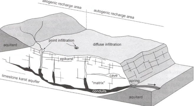
Figure 2.1: Epigenetic karst conceptual model that has to be modeled in this thesis. Modified from Goldscheider and Drew (2007)
2.1
Introduction and conceptual model
The conceptual model of epigenetic karst systems (Figure 2.1) states that Karst conduits are formed by preferential dissolution of given inception horizons. They can only form in karstifiable formations: there is a geologic control over the large scale structure of the aquifer. Moreover, the recharge processes of these aquifers are quite complex: on the one hand, a certain percentage of the precipitation infiltrates through the low permeability volumes, but on the other hand a great part of the recharge occurs on the form of concentrated (point) infiltration (Kir´aly et al., 1995). The concentrated infiltration has two forms: autogenic recharge and allogenic recharge. The autogenic recharge occurs when the precipitations occurring directly on the karst formation are concentrated by the epikarst towards the conduit system in the dissolutions forms of dolines. Allogenic recharge occurs on the contact between an aquitard formation on which rivers can flow and a karst formation, where the given river infiltrates directly into the karst aquifer conduit system through sinkholes. Moreover, at least two distinct zones are present in a karst conduit network: the vadose (or unsaturated) zone and the phreatic zone (or saturated). The conduits in the vadose zone tend to follow a subvertical path, while the saturated conduits follow a preferential subhorizontal path. The flow path between the inlets (sinkholes, dolines) and the outlets (springs) is supposed to follow a minimum effort path by the physical principle of minimization of energy.
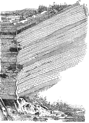
In the present section, the Valley of les Ponts-de-Martel (Jura Mountains, Switzerland) is presented, because it illustrates a typical epigenetical karst system that can be found in the Jura mountains. The Valley of les Ponts-de-Martel is underlained by a karstic aquifer whose main outlet is the spring of Noiraigue. It is located about 20 km East of Neuchˆatel city, in a highly tectonized area of the Jura Mountains in Switzerland. The site has been studied for more than a century (Desor, 1865; Daubr´ee, 1887; Schardt, 1906, 1908) and very soon the first conceptual models about the spring of Noiraigue behavior have appeared (Figure 2.2). The first known tracer test in the region to determine the hydrogeolgical link between the spring of Noiraigue and the sinkhole la Perte Du Voisinage was performed by Desor (1865).
Starting in the 70’s the first modern studies were carried out by the Center of Hydrogeology and Geothermics (IGH-CHYN) of the University of Neuchˆatel (Kir´aly, 1973; Morel, 1976; Gogniat, 1995a; Atteia et al., 1996; Valley, 2002; Gillmann, 2007; Borghi, 2008; Fournier, 2012). One reason for this interest is probably related to the proximity of the site with the CHYN.
24 Conceptual model and study site
Figure 2.2: One the first known conceptual models about the spring of Noiraigue behavior and recharge. From Daubr´ee (1887).
were:
1. Existence of a large dataset related to the geology, hydrogeology and climate. This allowed to apply the methodology without having to acquire too much additional data.
2. Proximity of the site, allowing to collect new data if needed.
3. High level of complexity, allowing to test the possibility of building a realistic model even in a complex setting.
The methodology proposed in this thesis is fully explained in the following chapters. The present chapter is intended to give the background information related to the Valley of les Ponts-de-Martel site to minimize redundancy within the rest of the text. Section 2.2 summarizes the geographical, geological and hydrogeological settings and section 2.3 describes the geological model of the Valley of les Ponts-de-Martel that was built earlier (Borghi, 2008) and that will be used further in the present thesis.
2.2
Description of the site
2.2.1
Regional situation
The chain of the Jura mountains extends for approximately 350 km in its internal part and 400 km in its external part. The chain presents an arched shape, and its width varies between a few kilometers to 65 km in its wider part between Besan¸con and Neuchˆatel. The Jura mountains are surrounded by tertiary sedimentary basins: in the North by the Rhein river graben, in the South by the Swiss Molasse basin and in the West by the “Foss´e de la Bresse” basin.
The chain is subdivided in 2 main regions, the internal and the external Jura. The Valley of les Ponts-de-Martel belongs to the internal Jura. The internal Jura consists in a succession of well formed folds. It is also called “la Haute Chaˆıne” (i.e. the High Chain). The characteristic deformations of this region are folds, overthrusts and strike-slip faults. The folds are closely related to thrusts. In many cases,
Description of the site 25
the folds are fault-propagation folds and fault-bend folds. The strike-slip faults are mainly sinistral and cut the folds with a high angle. Their orientation is mainly NE-SW in the Eastern part of the chain and rotate progressively to NE-SW in the western part of the chain. The southern limit of the chain plunges under the Molasse basin (Sommaruga, 1996).
The Jura mountains have been studied for more that three centuries. Valley (2002) gives an exhaus-tive overview of the available literature. One of the biggest controversies is the implication or not of the crystalline basement in the folding process. According to Sommaruga (1996) the basement is not involved, and the entire chain has moved over an evaporitic formation (mainly gypsum) at the base of the sedimentary cover in the Triassic formations.
2.2.2
Geographical situation
The Valley of les Ponts-de-Martel has an overall orientation of N45, and is situated in the Jura Mountain in the Canton of Neuchˆatel (Figure 2.3). Its length is about 20 km and its mean width is about 3.5 km, its surface is 70 km2. The central plain of the valley represent 2/3 of its surface, and the surrounding
mountains represent 1/3 of the surface. The altitude ranges between 980 masl and 1439 masl with a mean altitude of 1065 masl.
The main village of the Valley of les Ponts-de-Martel is “Les Ponts-de-Martel”. There are several other smaller villages called “La Sagne”, “La Corbati`ere”, “Martel Dernier” and “Brot Dessus” (Figure 2.3). The karst spring of Noiraigue is located in the village with the same name, in the Val de Travers valley. The outflowing water of the spring of Noiraigue flows in an important river of the canton Neuchˆatel, i.e. the Areuse river.
2.2.3
Geological settings
The main geological structures are detachment folds that evolved into fault-propagation folds after break-through of thrusts, with progressive deformation (Sommaruga, 1996). The orientation of their axis are commonly SW-NE.
The Valley of les Ponts-de-Martel is determined in its NW side by a long anticline which extends from the SW to the NE very regularly (N60). This anticline forms the chain of Sommartel mounts with a maximal altitude of 1338 masl (from nb 1 to nb 8 in figure 2.4).
The southern side is more complex. The main SE anticline is quite regular in its NE part (N40), but has a complex relay structure near the the spring of Noiraigue (point 2 in figure 2.4). In this relay structure, the anticline rotate from N40 to N110 in a highly fracturated and faulted zone. After this relay structure, the anticline closes the valley against the NW anticline towards the SE. This anticline forms the chain of Plamboz -Mont-Racine-Tˆete de Ran mounts (max altitude: 1439 masl).
These two anticline are both overthrusting: the SW anticline is on a regular overthrust with a SE dip, while the NW anticline is above a back-thrust structure with a NW dip (Borghi, 2008).
Between the two anticlines, the syncline of the Valley of les Ponts-de-Martel presents a mostly sub-horizontal dip, and a tertiary sediment filling (Molasse sandstone) of about 300m in the thicker part. Figure 2.5 present 3 cross-sections across the site. As it can be noticed, the valley tend to narrow in the NE part because the two anticlines are very close on to each other.
The study site crosses 4 geological maps: i.e. the 1:25’000 map of the Swiss geological atlas Val de Ruz (nb. 1144), Neuchˆatel (nb. 1164), Travers (nb. 1163, unpublished) and the 1:50’000 map of the French geological atlas Morteau.
The stratigraphy is very well known in the region, after 2 centuries of geological studies (Figure 2.6). In the study area, the outcropping formations go from the top of the Dogger (more precisely the Callo-vian formation) to the tertiary (Molasse). After the last ice age, glacial quaternary deposits have been deposited in the center of the valley (Valley, 2002). The most relevant formations for this study be-long to the Malm. They form the succession of the basal aquitard (Argovian marl formation) and karst aquifer (Sequanian, Kimmeridgian and Tithonian (Portlandian) limestone formations). Figure 2.6 gives a detailed log of the local stratigraphy1.
26 Conceptual model and study site
Figure 2.3: Geographical situation of the Valley of les Ponts-de-Martel . Yellow line: Swiss border; red line: Canton Neuchˆatel border; Satellite image taken from Google Earth. Modified from Fournier (2012)
2.2.4
Hydrogeological settings
Noiraigue spring (CH-1903: 545’688/200’964, altitude 737 masl) represents the main outlet the Valley of les de-Martel aquifer (Figure 2.3). From a geomorphological point of view, the Valley of les Ponts-de-Martel is a small endoheric catchment; it is in fact a polje whose totality of the precipitations infiltrates in the karst aquifer. The outcropping rocks of the catchment are composed by 22.5km2 of quaternary
sediments (31%), 2.9km2 of Molasse and Cretaceous (4.1%), 42.3km2 of Malm limestones (60.5%), and
about 3% of “other”. Morel (1976) affirms that the water of the spring of Noiraigue comes by 65% from the sub-outcropping limestones, 31% from the peat bogs of the Valley of les Ponts-de-Martel , and 3% from the Argovian combes (where Dogger may sometimes outcrop).
The three main aquifers of the region are the Dogger, Malm and Cretaceous aquifer. They are all karstified. The main aquifer of Noiraigue is the Malm aquifer (section 2.2.3). The mean discharge of the spring of Noiraigue is 2.02m3/s, with a minimum of 0.15m3/s and a maximum of about 15m3/s (Kir´aly,
1973; Morel, 1976; Fournier, 2012).
The infiltration of the precipitation occur in two ways: diffuse and point infiltration. Diffuse recharge occurs on the outcropping Malm limestone, while point recharge is localized in the numerous dolines and sinkholes around the valley (Figure 2.7). Two small rivers drain the plain (aquitard molasse) of the Valley of les Ponts-de-Martel : The “Grand Bied” river, which drains the North-Eastern part of the plain, and the “Petit Bied” river, which drains the SW part of the plain. Both rivers converge into the “Bied du Voisinage” river, which infiltrate directly into the sinkhole la Perte Du Voisinage (CH-1903: 545’725/204’900) which is the main sinkhole of the plain (Atteia et al., 1996) located near to Les Ponts-de-Martel village (Figure 2.3).
Description of the site 27
Figure 2.4: Tectonic situation of the Valley of les Ponts-de-Martel . Legend: 1. Combes Dernier; 2. Noiraigue; 3. Solmont; 4. La Tourne; 5. Mt Racine; 6. Val de Ruz; 7. Vue-des-Alpes; 8. Somartel; 9. Combe Cugnets; 10: Neuchˆatel lake. Modified from PGN (2008).
Figure 2.5: Tectonic cross section of the Valley of les Ponts-de-Martel . The positions of these cross-sections are located on figure 2.4. source: Atteia et al. (1996)
28 Conceptual model and study site
Figure 2.6: Stratigraphy of Canton Neuchˆatel. Compiled from earlier works (Sommaruga, 1997; Valley, 2002; Fournier, 2012) and using the updated international stratigraphic chart of 2012. (A. means Aquifer or Aquiclude. The Malm and Dogger limestones are considered aquifer formations, the Cretaceous is considered an aquifer as well, but only at regional scale. Tertiary molasse, Argovian marls and Aalenian marls are considered aquicludes or aquitard formations.
the rotation of the “Solmont” anticline (Figure 2.4) which can explain the presence of big karstic conduits in this zone (Gogniat, 1995a). Two small springs are related to the spring of Noiraigue: the “Epinette” and the “Libarde” springs. These small springs are temporary overflow springs which are active only during high water. Their discharge are far less than the discharge of the spring of Noiraigue (a couple of orders of magnitude). These three springs are situated in the Malm reservoir, and located at the contact between the aquiclude Argovian marls and the bottom of the Sequanian limestones.
The limit of the catchment have first been defined by Kir´aly (1973) on the base of the outcrop map of the aquiclude Argovian marl formation (74km2). A multitude of tracer tests has been performed on the Valley of les Ponts-de-Martel (presented in appendix B). These tests allow to slightly redefine the original catchment defined by Kir´aly (1973) as shown in Figure 2.7. The new catchment definition proposed by Gogniat (1995a) takes into account the dye test made in 1986 near La Corbati`ere (CH-1903: 554727/213601) which reappeared 10km to the N-NE and 25km to the NE from the injection point, but not at the spring of Noiraigue. In addition, the tracer test performed by (Matthey, 1992) near la Tourne
Description of the site 29
Figure 2.7: Noiraigue Spring catchment limit definition. (base map: 20m DEM)
(CH-1903: 550777/204413) shows a connection between this zone, which is unexpectedly connected to the spring. The hydraulic connection crosses the Argovian aquiclude somehow, probably because this region is highly fracturated. The retained version of the catchment definition is the one proposed by Fournier (2012) (blue surface in Figure 2.7). With respect to the catchment of Kir´aly (1973), its surface does not change consistently: Kir´aly (1973) catchment extension was 74km2and the new one is 73,5km2. This is important to keep the total water-balance consistent. One dye test is located outside the spring of Noiraigue catchment approximately 7km to the North of the spring. It has not been considered in the definition of the catchment because its author advanced the hypothesis of the contamination of the samples (appendix B) and because successive dye tests from the same location didn’t confirm this connection (Gogniat, 1995a).
All around the Valley of les Ponts-de-Martel a multitude of dolines are present. Fournier (2012) has mapped them using GIS processing of the new high resolution (1m) DEM of the region and manual verification. Their local catchment has also been computed by computer assisted techniques, and will be used later to evaluate the flow boundary conditions in section 6.3.5. These dolines occur often in the contact zone between the Malm aquifer and the aquitard tertiary molasse fulfillment around the Valley of les Ponts-de-Martel , and also in contact zone between the Malm aquifer and the argovian aquiclude (Gogniat, 1995a). The dolines are also visible in Figure 2.7.
2.2.5
Available hydrogeological data
Spring hydrograph
When studying karst aquifers, one of the most important set of observation data is the spring hydrograph. The spring hydrograph during the interest period had several missing data, because of instrument failures.
30 Conceptual model and study site
Figure 2.8: Measured and reconstructed discharge at spring of Noiraigue
a) b)
Figure 2.9: data reconstruction technique validation for the spring of Noiraigue discharge. a) recon-struction using linear correlation. b) reconrecon-struction using MPDS
Fortunately, the Areuse river hydrograph was known for these periods. Gogniat (1995a) shows a good correlation between the Areuse discharge measured in Saint Sulpice village and the discharge of the spring of Noiraigue.
In this chapter, a method that uses the Multiple Point Direct Sampling (MPDS) geostatistical algo-rithm is used to reconstruct the missing time series part. The MPDS algoalgo-rithm is described in Mariethoz et al. (2010) and its use for the reconstruction of missing data is described in Mariethoz and Renard (2010).
Unlike other multiple-point geostatistics algorithms (e.g. Strebelle, 2002; Straubhaar et al., 2011; Zhang et al., 2012) which allows to simulate only categorical variables (e.g. facies), the MPDS algo-rithm allows to simulate continuous variables, like e.g. the porosity of an heterogeneous aquifer. The algorithm needs a Training Image (TI) to “learn” how the variable is spatially distributed. Furthermore, an additional auxiliary variable can be provided. This variable provides to the algorithm a trend that can influence the simulation of the primary variable. In common geostatistical applications, the primary variable can be e.g. a flow property (like the porosity) and the auxiliary variable a geophysical measure-ment. If both TI (i.e. a TI for the primary property and a TI of the corresponding auxiliary variable) are provided, and if the auxiliary property is known for the simulation domain, the MPDS simulation results are more accurate than without the auxiliary variable.
Here, the primary variable is the spring discharge hydrograph. The training image is the spring hydrograph where it is known. The known part of the hydrograph is also used as conditioning data for the reconstruction simulation. The auxiliary variable is a stream or spring in the neighborhood, which is well correlated with the current spring. The auxiliary variable has to be defined over the domain that
Description of the site 31
has to be reconstructed, and on the training image domain. The known part of the spring of Noiraigue hydrograph is used as training image and as conditioning data, while the hydrograph of the Areuse is used as auxiliary variable. The role of the auxiliary variable is to influence the results of the simulation where there is a great lack of conditioning points in the primary variable, which is the variable that is simulated (in this case the spring of Noiraigue hydrograph). The resulting hydrograph is shown in Figure 2.8. In this case, only one equiprobable realization of the MPDS algorithm is shown.
Another way to retrieve the missing data has been tested as “reference method”: the computation of the missing data by linear correlation. The correlation straight line between the spring of Noiraigue discharge QN rg (m3/s) and the Areuse river discharge QAr is given by:
QN rg= 0.30 · QAr+ 0.47 (2.1)
with a linear correlation coefficient R2 of 0.84.
To validate the resulting reconstructed data for both techniques the available data from January 1st 1996 to January 1st 1997 of the spring hydrograph has been simulated. The hydrograph simulated with the MPDS algorithm shows a significantly better results (Figure 2.9) than the linear correlation method, which in this case systematically overestimate the discharge, while the MPDS gives a very good fit. The reason of this better fit is that it is very well influenced by the auxiliary variable.
Borehole data
In the 70’s, 6 deep boreholes have been realized in the Valley of les Ponts-de-Martel . Their depth is comprised between 200 and 450m. They have been realized on the border of the tertiary cover to investigate the limestone formations (Morel, 1976). Five of these wells have been monitored by Morel (1976) from 1971 to 1974. Gogniat (1995a) reactivated 4 of these wells in the first half of the 90’s and monitored one of them again. The data about these boreholes are presented in tabular 2.1. These two studies give interesting hypotheses about the hydraulic connections and behavior of the Noiraigue spring and these boreholes. Fournier (2012) tried also to reactivate the borehole of Martel Dernier, but it was stuck at 150m depth.
According to Morel (1976) and Gogniat (1995a), the boreholes of Brot-Dessous (BD), Petit-Martel (PM), and Combe Cugnet (CC), present a very similar hydraulic behavior (head variations), which are very closely correlated with the spring hydrograph. A direct hydraulic connection between these boreholes and the spring of Noiraigue is therefore very probable. The location of these boreholes is visible in Figure 2.7.
Borehole X Y Z Depth. Years* H
min Hmean Hmax
Petit Martel 548013 206735 1007 365 72 741 749 768
Brot Dessus 546750 203740 1019 450 72 / 97-98 738 741 760
La Sagne 552192 210674 1038 216 72 850 875 970
La Corbati`ere 554231 213037 1080 300 72 NaN 890 NaN
Martel Dernier 543584 203740 1023 305 72 831 840 855
*
72: period since 01.01.1972 to 31.12.1972; 97-98: period since 13.08.1997 to 11.02.1998.
Table 2.1: Malm aquifer piezometry. X,Y: geographic coordinates (CH-1903) of the well heads. Z: altitude of well heads. Depth: expressed in meters from the well head. Years: only one borehole could be measured by Gogniat (1995a) in 97-98. Hmin: minimal head value (m); Hmean: mean head value (m);
Hmax: maximal head value (m).
With the analysis of the borehole data, Morel (1976) and Gogniat (1995a) have identified three distinct flow systems:
1. The system of La Sagne - La Corbati`ere 2. The system of Martel Dernier