HAL Id: hal-01835402
https://hal-brgm.archives-ouvertes.fr/hal-01835402
Submitted on 11 Jul 2018
HAL is a multi-disciplinary open access
archive for the deposit and dissemination of sci-entific research documents, whether they are pub-lished or not. The documents may come from teaching and research institutions in France or abroad, or from public or private research centers.
L’archive ouverte pluridisciplinaire HAL, est destinée au dépôt et à la diffusion de documents scientifiques de niveau recherche, publiés ou non, émanant des établissements d’enseignement et de recherche français ou étrangers, des laboratoires publics ou privés.
Geology, Genetic Processes And Their Consequences On
Environmental Impacts At The Abandoned W Mine Of
Enguialès, Aveyron, France
Jérôme Jacob, Bruno Lemiere, Gaël Bellenfant
To cite this version:
Jérôme Jacob, Bruno Lemiere, Gaël Bellenfant. Geology, Genetic Processes And Their Consequences On Environmental Impacts At The Abandoned W Mine Of Enguialès, Aveyron, France. 11th In-ternational Conference on Acid Rock Drainage (ICARD 2018), Sep 2018, Pretoria, South Africa. �hal-01835402�
Geology, Genetic Processes And Their Consequences On Environmental Impacts At The Abandoned W Mine Of Enguialès, Aveyron, France
Congress theme :Geochemistry/ Hydrogeology
Geochemistry and hydrogeology lie at the core of water in the mining environment, and failure to understand their influence on mine water make and chemistry severely prejudices successful management and control of ARD or NRD in all phases of mining.
Authors (order to be set according to contributions)
JACOB, Jérôme (presenter), LEMIERE, Bruno, BELLENFANT, Gaël
Introduction
We investigate here arsenic issues at the Enguialès abandoned tungsten mine, their relationships with the ore genesis model, and the consequences of the hydrogeochemical reactions on the environmental impact of the site, and on the long-term site management plan.
Geological setting and mining history
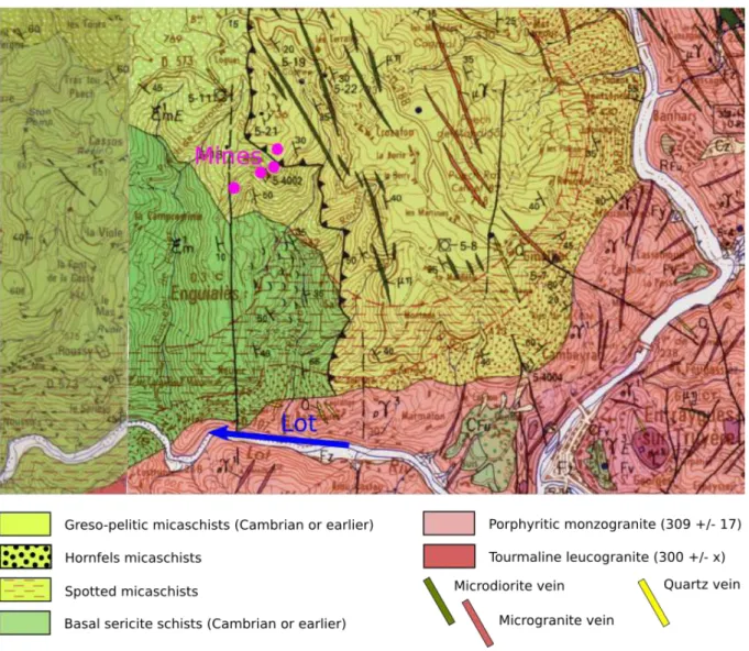
The former Enguialès mine belonged to the Leucamp – Enguiales regional tungsten district (Cantal - Aveyron region, French Massif Central), hosted in the pre-Hercynian micaschists sequence of "la Chataigneraie". This sequence was intruded during Silesian times (Monié et al., 1999) by several types of granites and microgranites. The Entraygues porphyritic monzogranite batholith occurs nearby the mine and probably under it. It has a distinctive contact metamorphism aureole of hornfels ans spotted micaschists, with abundant cordierite, poekilitic andalusite, biotite, tourmaline and rare sillimanite. It was intruded by a muscovite leucogranite and by microgranitic veins (Figure 1).
Figure 1: Geological map (from the 1:50000 map, Goer de Herve et al., 2006)
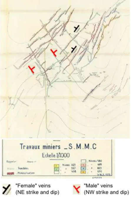
The mineralisation is hosted in a cross-patterned quartz vein stockwork covering 1,3 km x 0,3 km. The miners designated the veins with "male" names when they occurred along the regional schistosity (NW-SE strike, NE dip, thickness 1 to 50 cm) and "female" names when they crossed the schistosity (NE-SW strike, W dip, thickness 5 to 80 cm) (Figure 2). The recognised extension was 300 m long, with 200 m downwards dip.
The mine is located between 400 and 700 m elevation at the surface, across a steep slope above the Lot river valley.
The ore-bearing veins paragenesis comprises quartz, wolframite, scheelite, fluorapatite, while the hydrothermal alteration selvages paragenesis comprises tourmaline (schorl), sericite ans sulphides in a quartz greisen. Sulphides come as a first phase (pyrite, arsenopyrite) and a second phase (chalcopyrite, molybdenite, bismuthinite, marcasite), followed by a late carbonate phase. Secondary minerals developed through weathering include oxyhydroxides, hydrated sulphates, and arseniates, the most conspicuous being scorodite.
The vein-type, perigranitic nature, and the structural control result in a high arsenopyrite contents in the veins and their host rocks.
Figure 2: Vein network (from the mine 1:1000 plan)
Late Variscan leucogranitic magmatism and fluid circulation is believed to be the origin of mineralisation (Lerouge et al., 2000; Goer de Herve et al., 2006).
The deposit was discovered in 1957 by SMMC (Société Minière et Métallurgique du Chatelet) and mined from 1969 to 1978. Irregular distribution, recovery and productivity issues, and W price collapse (1971) led to mine closure in 1979. A total 450,000 t of ore averaging 0,6% WO3 was mined, yielding 1 300 t of 70% WO3
concentrates. A final attempt by the BRGM-S.M. d’Anglade-Petrofina-Charter consortium to locate extensions was not successful and the site was abandoned in 1983.
Ore beneficiation, according to the 1978 flow sheet, comprised crushing and staged milling (size fractions 5mm, 2mm and 0,8mm), pulp preparation, classification, and gravity sorting using jig concentrators or shaking tables. A last concentration step was added during the mine lifetime with froth flotation, using mainly gas oil, and then probably specific reagents such as xanthates, though this is not documented.
Processing residues comprised therefore +2-5mm gravel, +0,8-2mm dried sand, <0,8mm thickened sand, and sulphidic decantation sludge. Waste rock was used to build tracks and platforms. Process waste was dumped down the topographic slope out of the galeries.
Waste rock is not observable as large heaps. Due to the selective underground extraction method, and to the steep hillside topography, most of it was discharged near the adits and galleries. Most seems to have been used as engineering material to build platforms and access tracks along the slopes. Some may have been disposed by gravity but is now covered by vegetation.
Environmental impacts
(GB, BL, PhB, FC)
The Enguialès mine site is currently managed as abandoned with no responsible party. The first environmental studies were led in connection with EU mining waste inventories (Cottard et al., 2002). The widespread occurence of As-bearing phases in waste dumps was recognised by Courtin-Nomade et al. (2003) and confirmed by subsequent studies (unpublished data, 2017).
Figure 3: Air view of the site (Google Earth)
The structural control still applies to site hydrogeology and the faulted network channelises the As-rich fluids. Pyrite oxidation provided extensive Fe hydroxide coatings. Mining and beneficiation methods determined waste and residues typology. The underground mine opens on a steep topographic slope, on which waste rock and tailings were disposed. A first generation of gravity sorting on coarse mill feed gave moderately reactive quartz tailings, while later finer mill feeds and floatation techniques gave highly reactive and mobile tailings, with much higher As contents. Fast erosion of the latter, accelerated by the steep topography and the intensity of the rainy episodes, contributes to a high As load of surface water in particulate form. Acidic mine runoff is discharged nearby, favoring As and metals solubility, in the absence of any neutralising host rocks. traps. Fe hydroxide fracture coatings behave as natural arsenic retardants through sorption phenomena. This reduces groundwater As migration.
Methods
Geological, depth, air photo and topographic observations on waste
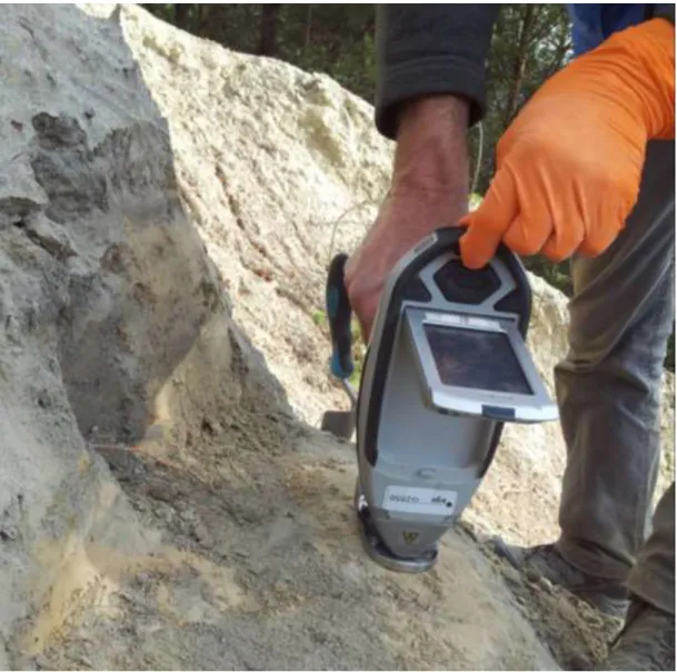
On-site geochemical analyses of waste were performed using portable X-ray fluorescence (pXRF) spectrometers (Niton XLt, XL3t, Olympus Delta 50). Both soil (Compton) and mining/geochem (fundamental parameters) modes were used in order to cover a large range of elements (As, Ba, Ca, Cr, Fe, K, Mn, Ni, Pb, Rb, S, Sn, Sr, Ti, V, W, Zn, Zr). Counting times in the 60-120 s range, and emission voltage in the 15-50kV were used. Relative accuracy was ensured by QA/QC blanks, duplicates and periodic CRMs measurement.
Figure 4: On-site analysis of residues using pXRF
Absolute accuracy was evaluated using laboratory analyses, performed by ICP/AES and ICP/MS after acid digestion of alkali sintered samples. Results were also compared with analyses after aqua regia digestion.
Water analyses were performed on site for physicochemical parametres (pH, ORP, EC) and by laboratory methods (ICP/AES, ion chromatography) for the main cations, anions and trace elements
Water monitoring on site was performed for 49 days in the (TB 465) runoff using an YSI 6920 multiparametric recording probe intended for environmental monitoring in waters with little or moderate mineralization (conductivity < 4mS/cm). The probe was calibrated offsite using standard solutions and checked onsite with an YSI control solution. The probe was set up to record hourly the following water parameters: pH, temperature, electrical conductivity (and by conversion, estimated salinity and TDS), Eh (redox potential), turbidity and dissolved oxygen. The latter two parameters are measured optically.
The probe was placed in a pipe retained by a dam of stones between the mine drainage spring and a small pond (see Erreur ! Source du renvoi introuvable.).
Figure 5 : Mine drainage spring (left) and pipe hosting the multiparametric probe (right)
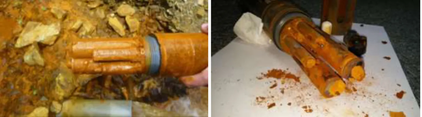
Figure 6 : The probe as recovered (left) and after gentle wiping (right)
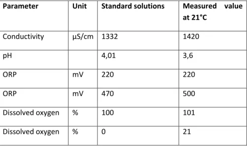
At the end of the monitoring period, the sensors were checked in the laboratory to evaluate their response to clogging by iron precipitate. It was necessary to lightly wipe sensors to carry out the verification (Figure 6), because during a first measurement without cleaning, the precipitates present on the surface of the sensors polluted the standard solutions. The results of this verification are presented in Table 1.
Table 1 : Results of the verification of the sensors of the probe with standard solutions
Parameter Unit Standard solutions Measured value at 21°C Conductivity µS/cm 1332 1420 pH 4,01 3,6 ORP mV 220 220 ORP mV 470 500 Dissolved oxygen % 100 101 Dissolved oxygen % 0 21
The various sensors have a relatively low drift given the important deposits on their surfaces, with the exception of the dissolved oxygen sensor for low concentrations. It can be concluded that if the absolute values provided by the probe require a critical reading, their relative values are representative of the events affecting mine drainage. In order to compare the variations of the mine drainage physico-chemical parameters with precipitation, rainfall data recorded by the Vieillevie weather station, located 9 km southeast of Enguialès, were used.
Results and discussion
Detailed site investigations by Cottard et al. (2002), Courtin-Nomade et al. (2003) and Baranger (2008) showed that the main environmental impact of the former mine was the emission of arsenic towards surface water, resulting from acid drainage out of the mine galleries and from the meteoric leaching of the waste dumps.
In order to understand better the origin of acid drainage, the mine runoff was continuously monitored. The mine drainage reaction to short but intense rainfall events was studied. These results were cross-referenced with data on the geology and the multiphase genesis of the mineralisation, as well as with the mining and beneficiation methods and their consequences on residues typology. An inventory of the extent of the contamination of the site and the transport modes of the contaminants (both in solute and particulate form) were carried out, taking into account the topography and the weather conditions. A risk classification of residues was made possible by detailed pXRF mapping.
Solid waste
The process waste deposits were mapped and analysed using pXRF in order to delineate source areas and to establish a preliminary ranking of their hazardousness. This was based on total As only, as no As speciation data could be collected.
leachable fraction differs significantly from the total As, the ranking of source areas and the remediation options remain the same.
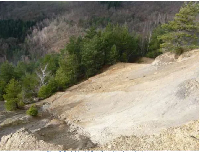
Figure 7: Eroded As-rich floatation residues in gravity dumps
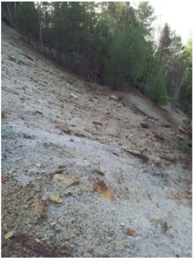
Two types of residues were observed and occur as separate masses along the slope. A grey to rusty, coarse-grained (millimetric) quartz-rich material occurs on the outer sides of the dump (Figure 8). It is believed to be the residue of mechanical gravity sorting processes, used in the early history of the mine. Their composition is roughly similar to the hydrothermally altered micaschists (Table 2, Table 3) but with anomalously high As and W. They are partly covered by vegetation.
Table 2: statistics of pXRF measurements on host micaschists and derived soil, in mg/kg<
Mo < LD
Table 3: statistics of pXRF measurements on coarse residues, in mg/kg
Zr Sr U Rb Pb As Zn W Cu Fe Mn Cr V Ti Ca K S Ba Sb Sn nb values 20 20 1 20 15 19 18 5 17 20 19 18 14 20 19 20 4 20 15 15 mini 42 26 118 14 16 32 49 31 29015 221 47 72 660 307 3929 2723 200 25 32 maxi 182 204 30 803 282 2034 225 488 370 152090 1659 159 126 5855 5355 29311 4076 1633 110 100 median 120 63 30 292 28 70 88 112 101 49803 594 85 94 2606 678 18761 3377 1026 56 64 average 124 72 325 47 325 92 178 118 62831 688 86 94 2906 927 17521 3388 969 59 63 Mo Zr Sr Rb Pb As Zn W Cu Fe Mn Cr V Ti Ca K S Ba Sb Sn nb values 6 11 11 11 11 11 8 11 10 11 11 9 10 11 11 11 4 11 3 7 mini 9 52 35 163 34 432 29 91 37 32914 212 36 56 1886 485 12441 1487 167 25 28 maxi 18 105 77 375 134 3122 50 1898 168 93991 563 94 137 3477 1091 24926 4811 579 35 56 median 11 81 52 194 47 598 36 366 49 44522 257 55 84 2531 692 17457 2649 401 33 34 average 12 77 53 222 60 898 38 464 66 47254 300 58 84 2554 769 18195 2899 398 31 38
A fine-grained (<1mm), white to pale yellow material occurs in the central part of the dump, immediately under the former processing plant. It is believed to be the residue of floatation processes with gas-oil ands xanthates, used in the late history of the mine, just before closure. This is supported by the location and by the observation of strong organic odours. A GC/MS scan for organic molecules confirmed the abundance of heavy petroleum hydrocarbons (C10 to C40), did not identify aromatic hydrocarbons but found S-bearing metabolites, probably from the degradation of xanthates.
Their composition is also roughly similar to the hydrothermally altered micaschists (Table 4) but with anomalously high Zn and Cu, and very high As and W.
This part of the dump is severely eroded (Figure 7) and the fine grained material is carried away to the river, especially during rainstorms. Almost no vegetation grows on this material.
Table 4: statistics of pXRF measurements on fine-grained residues, in mg/kg
Figure 8: As-bearing coarse gravity sorting residues in dumps
Mo Zr Sr Rb Pb As Zn W Cu Fe Mn Cr V Ti Ca K S Ba Sb Sn nb values 14 46 50 52 51 52 30 52 42 52 50 42 40 52 51 52 22 51 8 35 mini 10 33 18 162 21 214 31 153 37 13473 128 31 59 461 319 1872 1296 180 25 18 maxi 35 313 86 400 422 212336 1578 9423 6066 776331 1527 112 144 7592 1823 29131 51361 722 73 87 median 13 104 55 270 57 830 52 1031 91 41606 362 61 87 2559 699 18357 2246 422 36 30 average 16 107 55 263 81 11700 118 1479 445 86598 420 63 90 2654 762 17725 8784 426 41 33
Significant deviations were observed with ICP/AES analyses after aqua regia digestion for Sn, Ti, W, and Zr. For these elements, pXRF results are often more accurate than aqua regia analyses (Lemiere, 2018).
Mine water
Most of the mine drainage is observed as runoff at the TB465 outlet. It is then discharged to the nearby Crozafon creek and then to the Lot river, a little more than 2km downstream. The outlet and the creek have been monitored through sampling programs (Cottard et al., 2002, unpublished data, 2017).
The probe remained in place for 49 days, but the accumulation of iron hydroxide precipitate heavily clogged its sensors. When the probe was recovered, the pipe in which it was placed was completely clogged. Water was no longer flowing through the pipe, but the probe was still in the pond water. Consequently, the recorded values correspond to the physico-chemical parameters of this pond.
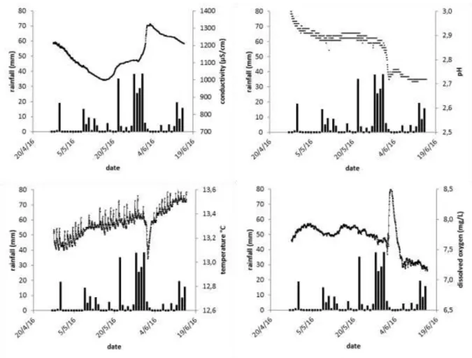
Results of conductivity, pH, temperature, dissolved oxygen concentration and rainfall measurements are presented in Figure 9. The ORP sensor seems to have been particularly affected by precipitates, as it hardly recorded any significant variations. The recorded data are largely unusable and therefore the results of the ORP measurements are not presented.
Figure 9: Conductivity, pH, temperature, dissolved oxygen concentration and rainfall during water monitoring period
The monitoring period was marked by a continuous heavy rain event from May 28th to 31th, and an intense but isolated rain event on May 22nd. The remainder of the monitoring period was generally dry with a few days of low rainfall.
The conductivity shows a sharp increase between May 28th and June 1st, followed by a slow decrease until the end of the monitoring period. This increase is due to the leaching and dissolution of oxidized minerals in the levels of the mine above the water table. These minerals, most of which are soluble, were washed or submerged during the heavy rain event while they are usually out of the water. The period of decrease in conductivity observed from April 27th to May 15th could correspond to a seasonal variation, or be the result of a prior rain event.
The pH is globally stable until a brutal acidification episode between May 31 and June 2. This increase in acidity is probably due to the leaching of oxidised sulphide minerals in the mine cavities. Usually, some of these minerals are above the water table where they react with air oxygen and with the seepage of oxygenated water. During the passage of water during an intense rain event, they are therefore already oxidized and they dissolve very quickly, releasing sulphuric acid and dissolved metals (Fe, Pb, Zn, etc.).
The water temperature varied within a very limited range between 13.0 and 13.6°C. Overall, we observe the usual warming of the weather between April and June. Between May 30th and June 2nd, the temperature drops and then rises sharply. This
drop in temperature partly covers and follows the main rain event of the study period. Besides the influx of colder rain water, it could be due to a decrease in the residence time of the water underground and thus a lower warming of water by the geothermal gradient. This is further supported by the time shift between rainfall and temperature change, which would not be observed if the mine aquifer did not play a role.
Dissolved oxygen concentration is generally stable except for a sudden increase between May 31 and June 2 followed by a slower decrease until June 6. This increase is probably due to an intensification of the flowrate of the mine drainage spring at the emergence caused by the increase of the water pressure load under the effect of the important water inflows. These variations in dissolved oxygen concentration would therefore indirectly reflect variations in drainage flow. The decrease in dissolved oxygen would represent the progressive emptying of the mine until it returns to its base flow. The fact that the dissolved oxygen concentration drops to a lower level (70%) than its base level before the intense rainy episode may be attributed to sensor sealing by precipitates.
Heavy rains were followed by strong increases in acidity and conductivity, As, sulphate and metal contents. The increase in As and metal contents being concomitant with the increase in flow rate, this means that despite their short duration, these intense rainfall events can represent a significant proportion of the As and metal discharge to the environment throughout the year.
Conclusions
The main impact of the abandoned Enguialès tungsten mine is the release of arsenic towards surface water, through process waste erosion and leaching, and through mine runoff.
For the former, a detailed geochemical mapping of residues allowed to identify fine-grained floatation residues as the main source. The steep slopes and the stormy rainfall regime imply that erosion contributes massively to As particular transport, while solute As release by rainfall leaching could not be precisely located. As leaching is probably active but diffuse.
For the latter, water monitoring showed a slowly mitigating As release from the mine runoff but does not allow to investigate in detail the relationships with meteoric events. Continuous monitoring is more efficient for transfer evaluation and modelling than periodic sampling.
Such data, along with pXRF waste mapping, are essential data for a site management plan to minimise long-term environmental impacts.
References
Bogdanoff S., Cirodde J.L., Ploquin A, Ramboz C (1987) - Recherche du tungstène dans le district de la Châtaigneraie (Cantal, Aveyron - Massif Central français). Géochimie des schistes de la Châtaigneraie. Chronique de la recherche minière, 487, 11-30.
Cottard F., Bouroullec I., Dutartre Ph., Fleury L. (2002) – Audits environnementaux de six mines fermées ou abandonnées de la région Midi-Pyrénées. Rapport BRGM RP-51538-FR. 76 p., 8 fig., 20 tabl., 3 ann.
Courtin-Nomade A, Bril H, Neel C, Lenain J-F (2003) - Arsenic in iron cements developed within tailings of a former metalliferous mine-Enguialès, Aveyron, France. Appl Geochem 18(3):395–408.
Couture, R.M., Rose, J., Kumar, N., Mitchell, K., Wallschläger, D. & Van Cappellen, P. (2013) - Sorption of arsenite, arsenate, and thioarsenates to iron oxides and iron sulfides: a kinetic and spectroscopic investigation. Environ Sci Technol. 4, 47(11):5652-9.
Goër de Hervé A. (De), Bogdanoff S., Couturié J.P. (2006) – Geological map of France (1/50 000), sheet Entraygues-sur-Truyère (836). Orléans : BRGM. Explanatory notes by M. Duguet, S. Bogdanoff, M. Turland, P. Nehlig, P. Lebret, G. Ricodel, R. Simon-Coinçon, M. Thiry (2006), 173 p.
Lemiere, B., Auger, P. (2017) – Expertise environnementale de l’ancien site minier d’Enguialès (Concession de Mirabel) (Aveyron). Unpublished report BRGM/RP- 65508-FR, 77 p., 75 fig., 4 ann.
Lemiere, B. (2018) - A review of pXRF (field portable X-ray fluorescence) applications for applied geochemistry. Journal of Geochemical Exploration 188, 350–363.
Lerouge, C., Bouchot, V. & Guerrot, C. (2000) - Fluids and the W(±As,Au) ore deposits of the Enguialès-Leucamp District, La Châtaigneraie, French Massif Central. Journal of Geochemical Exploration 69–70, 343–347.
Monié P., Bouchot V., Faure M., Charonnat X., Najoui K. (1999) - 40Ar/39Ar Laser-Probe Dating of W, Au and/or Sb Deposits and associated granites in the Southern French Massif Central (Cévennes, Châtaigneraie). EUG 10, abstract volume, Strasbourg, France.