Publisher’s version / Version de l'éditeur:
Canadian Geotechnical Journal, 1, 2, pp. 104-114, 1964-03
READ THESE TERMS AND CONDITIONS CAREFULLY BEFORE USING THIS WEBSITE.
https://nrc-publications.canada.ca/eng/copyright
Vous avez des questions? Nous pouvons vous aider. Pour communiquer directement avec un auteur, consultez la première page de la revue dans laquelle son article a été publié afin de trouver ses coordonnées. Si vous n’arrivez pas à les repérer, communiquez avec nous à [email protected].
Questions? Contact the NRC Publications Archive team at
[email protected]. If you wish to email the authors directly, please see the first page of the publication for their contact information.
NRC Publications Archive
Archives des publications du CNRC
This publication could be one of several versions: author’s original, accepted manuscript or the publisher’s version. / La version de cette publication peut être l’une des suivantes : la version prépublication de l’auteur, la version acceptée du manuscrit ou la version de l’éditeur.
For the publisher’s version, please access the DOI link below./ Pour consulter la version de l’éditeur, utilisez le lien DOI ci-dessous.
https://doi.org/10.1139/t64-004
Access and use of this website and the material on it are subject to the Terms and Conditions set forth at
Earthflows at the Beattie Mine Quebec, Canada
Eden, W. J.
https://publications-cnrc.canada.ca/fra/droits
L’accès à ce site Web et l’utilisation de son contenu sont assujettis aux conditions présentées dans le site LISEZ CES CONDITIONS ATTENTIVEMENT AVANT D’UTILISER CE SITE WEB.
NRC Publications Record / Notice d'Archives des publications de CNRC:
https://nrc-publications.canada.ca/eng/view/object/?id=b674ef12-d446-4aef-9fa4-0117448d4ccc https://publications-cnrc.canada.ca/fra/voir/objet/?id=b674ef12-d446-4aef-9fa4-0117448d4ccc
EARTHFLOWS AT THE BEATTIE MINE QUEBEC, CANADA*
I n June 1943 a n earthflow involving more than one million cubic yards of varved clay occurred a t the Beattie Mine. Subsequent remedial measures resulted in further large landslides. This paper describes the soil con- ditions, the sequence of events, and attempts t o assess the stability of the clay slopes. I t was found t h a t the undrained analysis led t o a n unsafe assessment b u t t h a t Terzaghi's rule for critical heights of slope gave a better indication of stability.
E n juin 1943, un glissement de terrain d'au dCla d ' ~ ~ n nlillion d e verges carrCes d'argile stratifiCe survint B la mine Beattie, Province cle Quebec. Les mCsures de protection qui furent prises par la suite entrainhrent cepen- dant d'autres Cboulis. Cette com~nunication decrit les conditions du sol, la suite des Cvhne- ments, et des tentatives pour Cvaluer la stabilite de ces talus d'argile. Les rCsultats indiquent qu'une analyse fondCe sur des essais non drain& conduit B une apprCciation dangereuse, alors q u e la loi d e Terzaghi, en rapport A la hauteur critique des talus, donne une m e i l l e ~ ~ r e indication de la stabilith.
The Beattie i\iIine is located in north-western Quebec a t the village of Dupar- quet, about fifteen miles south of Lalce Abitibi, in a clay plain resulting from the accumulation of varved clay deposited in glacial Lake Barlow-Ojibway. An open pit or "glory-hole" was gradually enlarged in the course of mining opera- tions so that larger and larger amounts of varved clay were stripped away from the perimeter of the pit. In June 1943 a rocltfall triggered a landslide in the clay slopes that developed into an earthflow involving more than one million cubic yards. Atteinpts to rehabilitate the mine resulted in further serious landslides in 1945 and 1946. This paper is a case record of the disaster, with emphasis on the performance of the varved clay. The performance of the clay slopes is compared with results of soil tests conducted in 1960 and
1961.
The Beattie Mine began production in 1933 with gold-bearing ore won from a large, relatively low-grade ore body lying along the north flank of a rock ridge oriented in an east-west direction. Approximately 200 yards north of this ridge, another ridge, formed of glacial till, defined the intervening valley, which was filled with varved clay underlain by sand.
At its west end the ore body outcropped on the surface, plunging under the overburden towards the east. Ore was mined by a combination of glory-hole and unclerground stoping methods. The glory-hole was an open pit with very steep sicles and sloping ends; a hanging wall was supported on a footwall by four roclc pillars across the pit. The ends of the pit sloped a t about 40 degrees. Ilere, the ore was mined and rolled down the slope to an underground opening in the pit bottom. Production was scheduled so that the glory-hole was worked
"Presented a t 17th Canadian Soil Mechanics Conference, Sept. 12, 1963, Ottawa. tSoil Mechanics Section, Division of Building Research, National Research Council, Ottawa.
EDEN: EAKTHFLOWS AT THE DEATTlE M I N E 105
during the surnmer ~iionths and the more expensive underground mining w a s conducted during tlie winter.
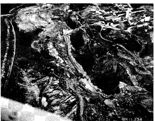
Figure 1 is an aerial view of the mine taken in 1938 and shows the pit with its system of pillars. By 1943 the glory-hole was about 1000 ft. long, 40 f t . wide a t the east end, and over 200 ft. a t the west. At its deepest point tlie pit was about 300 ft. below tlie surface.
I 1 Aerial view of Beattie Mine, 1938 (courtesy of Beattie-Duquesne Mines Limited)
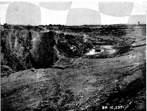
As production proceeded the pit was gradual!y lengthened, requiring t h e stripping of greater and greater depths of overburden fro111 the north side and east end. I n the early stages the stripping was accomplished b y liorse- drawn scrapers, but as the amounts of stripping grew larger a tower dragline system and mechanical excavating ecluipmcnt were ~ ~ s e d . I n each case the stripped material was deposited near tlie top of slopes c u t in the overburden a t 4:1, a fairly wide berm bordered the pit. Figure 2 illustrates the clay slopes a s they were in 1943. A puinp barge, sliown in the photograph, controlled seepage water. The maximum depth of overburclen excavated by 1943 was approximately 100 ft., and consisted of 8.5 ft. of varvecl clay overlying 15 ft. of sand or till.
Tlic varved clay was cleposited in glacial Lake Barlow-Ojibway (Antevs, 1925) and was found Inter to be nearly normally consolidated. T h e clay ' occupied a narrow valley north of the ore body and extended westward about one mile t o tlie shores of Lake Duparquet. A t its lowest point the rock rim of the pit was about 60 ft. below the level of Lake Duparquet (elevation 885).
106 CANADIAN GEOTECHNICAL JOURNAL
FIGURE 2. Clay slopes, 15 June 1943 (courtesy of Mr. F. E. Patton)
Seismic surveys conducted about 1946 have shown that there was no ledge of bedrock to iinpecle seepage between the rinl of the pit and the lake. Near the west end of the pit there was a tailings disposal area flooding the low- lying ground west of the mine. Records indicate co~~siclerable seepage through the sand, particularly a t the west end of the pit.
THE EARTHFLOWS
The first difficulties with the clay slopes were recorded in 1937. On 19 June a landslide occurred 011 the north-east corner of the glory-hole. As shown
on Figure 3, it had the characteristic shape of a n earthflow and involved a few thousand yards of clay. The second recorded slide occurred in 1942, mid- way along the north side of the pit. Like the previous slide it was relatively small and did not seriously affect operations in the mine.
On the night of 13 June 1943, however, a very large earthflow involving more than one million cu. yd. occurred. The glory-hole was con~pletely filled, and owing to the fluidity of the clay inany of the underground workings were penetrated. Some of the clay ran nearly half a mile along the sixth level drift towards the neighbouring Donchester Mine, which was connected t o the Beattie Mine on this level. The inlinediate cause of the landslide appears to have been the collapse of a main pillar in the pit; this caused a rockfall on the north side and, in turn, initiated the earthflow. As indicated on Figure 3 the landslide involved a large area of clay north and east of the pit. Borings made in 1960 and 1961 indicate t h a t nearly all the clay in this area of the pit was removed by the earthflow.
T h e neighbouring Donchester Mine ( ~ ~ n c l e r the same mzunagement a s the Beattie Mine) remainecl i n operation while steps were taken towards the rehnbilitation of t h e Beattie i\line. I n the ~~ndesgrouncl \vorl;ings the clay was sl~~icecl with high pressure water jets and the resulting slurry pumped t o the surface. Snlall hydraulic dreclges were set LIP in the glory-hole and crater t:o renlove clay fro111 the wor1;ing area. By Jwne 1946 about 13 nlillion cubic yarcls had been removed from the pit. I t was estimated t h a t a further one million cubic yards would have t o be renlovecl before p s o c l ~ ~ c t i o ~ l could be resumed.
During 1945 further landslides occurred a t tlne west end of the crater, ~ ~ n d o i n g some of the worl; of the dredges. These collti~~uecl into 1946, tine largest, on 25 June 1946, involving about 250,000 cubic yartls. Figure 4 sllows photographs taken in July 1946 t h a t illustrate tlne landslides. Frolll informa- tion obtained from the former mine engineer, it- appears that the slides a t the
I;~c;u~ir 4. View of Mine from west entl s h o \ v i ~ ~ g recent landslides, J u l ~ 19-16 (courtes!. of RIr. F. I.:. P a t t o u )
west encl were rather shallo\v, involvi~lg perllaps the top 20 to 25 ft. of the clay. The first evidence of a slide wo:~ld be ;l tension crack; two or three days
later a sudden movement would occur, causing the clay to l i q ~ ~ e f y and flow rapidly towards the dredges located several h~~nclred feet t o the east. Observers could not associate the occurrence of the slides directlj- wit11 the operations of the clredges. Slides continuecl, however, ~ ~ n t i l September 1946 when dredging \vork was suspended.
I n the fall of 1946 a clecline in tlle price of gold brought a n encl t o large-scale operations a t the Beattie Mine. From 1946 to 1956 the pit area was kept free of water, and a shallo\\r shaft was sunk a t the west end to reach a lode of comparatively rich ore. Since 1956 no furtller work has l~een done, and the pit area has been allowed to flood from local drainage. Figure 5 is a photograph illustrating the area in RiIay 1960. This view is approxilllately the same as that in Figure 4. T h e shores of the lalie that can he see11 are the scarps left
EDEN: EAI(THFLO\VS AT THE BEATTIH M I N E Ion
FIGUI:H 5. View of Mine froin west end, May 1'360
by the landslides; the rock wall a t the right is the foriner footwall of the pit and the rocl; point jutting out of the water is the top of the hanging wall.
SOIL INVESTIGATIONS
During 19GO and 1061 field woi-1; consistecl of taking a number of borings and conducting surveys. All active mjning worl; had ceasecl in both the Don- chester and the Beattie Mine, and access to the area was rather difficult; because of the flooding of the pit area it was not possible to locate the borings ideally. They were illade inidway along the north side of the crater and at the west end (Figure 3). Fro111 visual illspectioil and froin the results of the borings on the north side i t was thought t h a t illost of the clay north a n d east of the mine had been reinoved by the landslides. Oilly a t the west end was there an appreciable depth of clay remaining, and it was here t h a t nlost of the detailed investigation was concentrated. A series of low-level vertical aerial pl~otograpl~s had been talcen of the mine area d ~ ~ r i n g July 1045. Fronl these it was possible to iualce a reasonably accurate contour inap of the west end of the pit. h/Iany of the mine p l a ~ ~ s showed contours of the slopes a t various s t a g es.
In general, the sequence of the soil strat-a consists of from 0 to 15 ft. of silty sand on the surface, a horizoil of varved clay up to 80 it. thick, and then a saitdy stratunl underlain by bedrocl; or glacial till on the north side. Borings 61-3 and 61-4 were locatecl a t the west end of tlie crater, ancl tlie logs fi-om these borings are presented in Figure 6. Field vane test-s were conducted a t 1 ft. intervals in the clay. In hole 61-3 thin-walled tube saillples were talcen with the NGI-type fixed-pistoit sampler.
In Figure G , the boring log sliows that the top 15 ft. consist of silty sand- very loose inaterial that was easily penetrated by the drill casing. The varved clay stratum extencls Irom 15 to 55 ft. Xear the top of it the dark layers are thiclier than the light layers, altl~ough both may be considered clay
EDEN: EARTHFLOWS AT THE BEATTIE M I K E 111
materials. With increase in depth the ratio of dark to light layer changes, until a t the botto~ll of the clay the light layers are thiclter than the dark layers and consist of sandy silt. The dark layers continue to be clayey with reduced plasticity; the water content profile shows this tendency.
The undrained shear strength increases with depth, with the apparent c / p ratio remaining nearly constant. Field vane strengths range fro111 about 400 Ib./sq. ft. a t an elevation of 913 to 1000 lb./sq. ft. a t an elevation of 880. The apparent c / p ratio is about 0.4, this value being partially attributable to an overconsolidation process. T h e consolidatio~l test results indicate t h a t the clay has been affected by the mine drainage system. I t is postulated that this draindge caused a full draw-down and the initially nor~llally co~lsolidated clay tended to be consolidated by the full overburden pressure.
A series of undrained triaxial and ~~nconfined conlpression tests was con- ducted on the tube samples. These i~ndrained strengths were appreciably less than those indicated by the field vane test. These results co~lfirnl that dis- turbance is a serious factor in sa~npling varved clays, as sholvn in a previous investigation (Eden and Bozozuk, 1962).
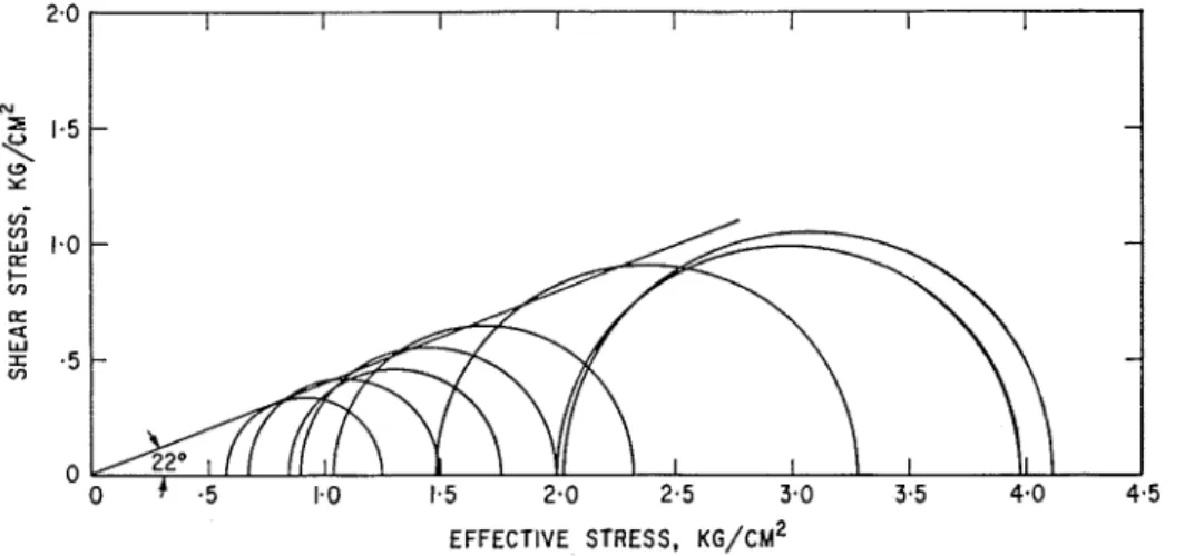
Consolidated undrained (CU) triaxial tests were conducted on a nunlber of specimens. A change in the shear characteristics of the material is indicated as occurring a t an elevatioil of about 890, the nlaterial below this elevation llaving an angle of shearing resistance 4' of about 28 degrees and that above it about 22 degrees. Results of the tests on the upper clay are presented in Figure 7, which is a Mohr diagram showing the effective stress circles a t the nlaxi~llunl deviator stress obtained during the test. All these tests were con- ducted a t consolidating pressures greater than the preconsolidation pressure of the samples. The average c l p measured was 0.29.
In summary, it appears t h a t initially the varved clay was al~llost normally consolidated. Owing to the drainage ~vorks, the clay has been partially con- solidated under full overburden pressure. I-Ience, the undrained strengths
EFFECTIVE STRESS, K G / C M ~
112 CANADIAiX GEOTECHNICAL J O U R N A L
measured with the field vane are probably higher than those existing at the time of the landslides. This effect will be greater with depth.
Information concerning the slopes prior to 1943 is lacking in the detail necessary to conduct a stability analysis. I t is interesting to note, however, that i f the slopes were cut to 4:1 as planned, they would be critical according t o the analysis proposed by Gibson and Morgenstern (1962) and using the
c / p measured in the triaxial test. I t is thought t h a t the clay would have been
nearly norinally consolidated a t that stage. On the other hand, the stripping was carried out rather slowly, allowing the slopes to drain to a certain extent as construction proceeded.
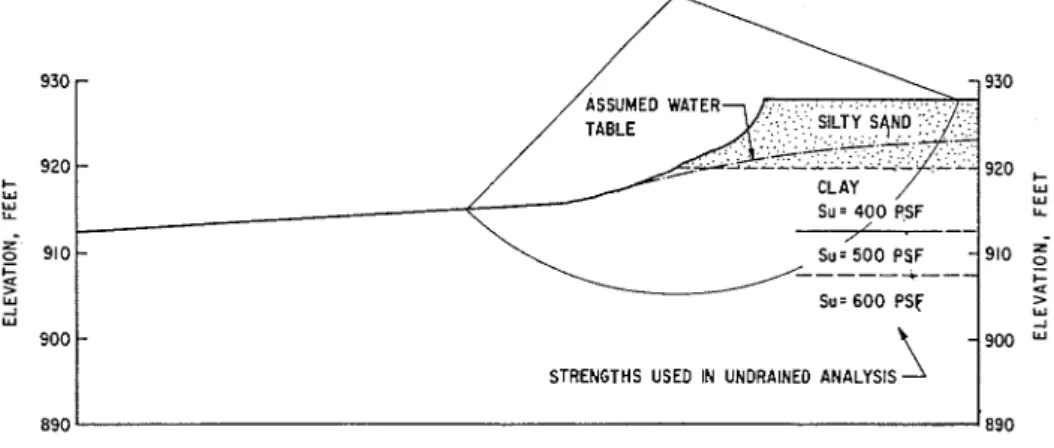
Using the aerial photographs taken in June or July 1945, it was possible t o obtain reasonablv reliable slope profiles for the west end of the mine where slope failures were occurring. The steepest profile obtained is shown on Figure 8. Both total stress and effective stress analyses were attempted on this profile.
Su = 4 0 0 PSF LL
I
STRENGTHS USE0 IN UNORAINED ANALYSISFIGURE 8. Profile X-X a t west end
For the undrained analysis several shallow circles were tried using shear strengths of 400, 500, and 600 Ib./sq. ft. according to the depth of the circle and the measured field vane strengths a t corresponding elevations. No strength was assigned to the siltv sand stratum on the surface. Although the strengths measured with the vane in 1961 were considered to be slightly higher than the strengths a t the time of the landslide because of consolidation, this analysis might be expected to give a reasonable indication of potential instability. However, the minimilin safety factor obtained was 2, and the analysis cannot therefore be considered satisfactory. The large discrepancy between the calcu- lation and the observed behaviour of the clay cannot be accounted for by the consolidation effect alone.
The situation a t the Beattie Mine can be coinpared with the varved clay slopes a t Steep Rock Iron Mine (Legget, 1958) where 22 ft. high slopes a t 3:l
EDEN: EARTHFLOWS AT THE BEATTIE M I N E 113
frequently failed under rapid drawdown conditions although the average shear strength was 550 Ib./sq. ft. The undrained analysis of these slopes yields a safety factor of 1.7. At Steep Rock, Sutherland (1959), found that Ter- zaghi's (1948) rule for a critical height of slope against failure by spreading could be applied t o the Steep Rock slopes. This rule, Hc = 4cIY, is based on the assumption that excess pore water pressure is developed in the clay along a horizontal plane sufficient to overcoine the undrained strength. At Steep Rock, the ~ ~ n d r a i n e d strength was 550 lb./sq. ft. and the critical height was 22 feet. At the Beattie Mine, the height of the slope shown in Figure 8 was about 16 feet, which is in agreement with the undrained strength of 400 lb./sq. ft. There remains the problem of explanation of how the excess pore pressure equivalent to the undrained strength could develop. The writer can suggest only that this would require coinplete structural collapse along one layer in the varved clay.
An effective stress stability analysis (Bishop, 1955) was made assuilling the position of the zero water pressure line shown in Figure 8. Using 4' = 22
degrees, and c' = 0, the minimum safety factor of 0.9 was obtained from a
number of trial circles. Because of the consolidation of the clay, however, the assumption t h a t c' = 0 is probably too stringent. On the other hand, the zero water pressure line probably conformed very nearly with the ground surface during the period of spring thaw. Since the effective stress analysis is influenced greatly by both the value of c' and the pore water pressure, this analysis cannot be considered a reliable confirmation of the method.
I t has been the purpose of this paper to illustrate the behaviour of excavated slopes in normally consolidated varved clays. The experience a t the Beattie Mine is by no means uniclue; dredging operations a t Steep Rock Lake indicated similar behaviour (Legget, 1958). I t seellls usual for the varved clays on the Canadian Shield t o have water contents above their liquid limits so that they are subject to earthflows.
The undrained analysis, although apparently successful for cases involving loading (Milligan et al., 1962; Eden and Bozozuk, 1962) does not seem t o be reliable in assessing the stability of some cuttings, particularly cuttings sub- jected to rapid changes in stress conditions. Experience a t both Steep Rock and the Beattie Mine indicates t h a t Terzaghi's rule concerning the critical height of a slope is a good indication of stability. Hence, it is suggested t h a t deep cuts in these clays should be carried o u t by a system of benches and berms, with the height of the upper benches less than the critical height.
The effective stress stability analysis appears to be a more reliable indication of stability than the undrained or total stress analysis, b u t it is difficult to derive a realistic value of c'.
This study was conducted wit11 the kind co-operation of Mr. W. R. Salter, President, Beattie-Duquesne Mines Limited. Mr. R. Gilhuly of the mining company a t Duparquet
114 CANADIAN GEOTECHNICAL J O U R N A L
assisted greatly in giving access to the mine records a n d in the search for information. Mr. F. E. Patton of Icitchener, Ontario, former Mine Engineer, provided a number of photographs taken from 1943 to 1946 and was helpful with his criticism and observations. The writer was assisted during 1961 by Professor I<. Van Dalen of Carleton University, Ottawa, in both the field \\.ork and in the preparation of plans and proliles from the mining records. Mr. hI. C. van \Vijlc of the Photogrammetric Research Section, Division of Applied Physics, National Research Council, made the plan from aerial photographs, xvhich provided the basis for the stability analysis. Finally, the help in testing provided by his colleagues in Soil mechanics Section DBR/NRC is gratefully aclcnowledged by the writer.
This paper is a contribution from the Division of Building Research, National Research Council, and is published with the approval of the Director who was first consulted about the failure when the Division started its work in 1947. 'The paper is one of a series being prepared within the Division t o present constructive results derived from the careful study of engineering failures, when these can be undertaken with the agreement of the responsible authorities a n d it is seen that they provide information of value to the engineering profession.
ANTEVS, E., 1925. "The retreat of the last ice-sheet in Eastern Canada." Geological Survey of Canada, Ottawa, Memoir no. 146.
BISHOP, A. \V., 1955. "The use of the slip circle in the stability a~ralysis of slopes." Ge'otech-
niptre, 5 , 1: 7-17.
EDEN. \V. 1. and Bozozu~c, M., 1962. "Foundation failure of a silo on varved clay." Ennitaeer-
i n g
"Journal,
45, 9: 54-7.GIBSON, R . E. and MORGENSTERN, N., 1962. "A Note on the stability of cuttings in normally consolidated clays." Gkotecl~nipue, 1 2 , 3 : 212-16.
LcccaT, R. F., 195s. "Soil engineering a t Steep Iioclc Iron Mines, Ontario, Canada." l'roc.
I ~ l s t n . Civ. Engrs., 1 1 : 169-8s.
MILLIGAN, V., SODERIIAN, L. G., and Rv,rIc.k, A., 1962. "Experiel~ce with Canadian varved c1a)s." Soil Mechanics and Foundation Division, l'ror. Anzer. Soc. Civ. Engrs., 88, S M 4: 31-68.
SUTAEKLAND, H. B., 1959. "Discussion on soil engineering a t Steep Roclc Iron Mines, On- tario." Proc. I n s t n . Civ. E?zgrs., 1 3 : 10'2-3.
TERZAGHI, K. and PECK, R. B., 1948. 5'011 11zecha7~ics in e?zgi)aeeri?zg practice (Xew York: IYiley).