Publisher’s version / Version de l'éditeur:
Vous avez des questions? Nous pouvons vous aider. Pour communiquer directement avec un auteur, consultez la première page de la revue dans laquelle son article a été publié afin de trouver ses coordonnées. Si vous n’arrivez pas à les repérer, communiquez avec nous à PublicationsArchive-ArchivesPublications@nrc-cnrc.gc.ca.
Questions? Contact the NRC Publications Archive team at
PublicationsArchive-ArchivesPublications@nrc-cnrc.gc.ca. If you wish to email the authors directly, please see the first page of the publication for their contact information.
https://publications-cnrc.canada.ca/fra/droits
L’accès à ce site Web et l’utilisation de son contenu sont assujettis aux conditions présentées dans le site LISEZ CES CONDITIONS ATTENTIVEMENT AVANT D’UTILISER CE SITE WEB.
Proceedings, Third International Peat Congress, pp. 174-181, 1970-05-01
READ THESE TERMS AND CONDITIONS CAREFULLY BEFORE USING THIS WEBSITE. https://nrc-publications.canada.ca/eng/copyright
NRC Publications Archive Record / Notice des Archives des publications du CNRC :
https://nrc-publications.canada.ca/eng/view/object/?id=321f6e86-e5ae-4917-bbeb-1f770d90e53b
https://publications-cnrc.canada.ca/fra/voir/objet/?id=321f6e86-e5ae-4917-bbeb-1f770d90e53b
NRC Publications Archive
Archives des publications du CNRC
This publication could be one of several versions: author’s original, accepted manuscript or the publisher’s version. / La version de cette publication peut être l’une des suivantes : la version prépublication de l’auteur, la version acceptée du manuscrit ou la version de l’éditeur.
Access and use of this website and the material on it are subject to the Terms and Conditions set forth at
Occurrence of permafrost in Canadian peatlands
Ser
TK1
N21r2
no. 432
c.
2
BLDG
O C C U R R E N C E
OF
PERMAFROST
IN
CANADBAN PEATLANDS
BY ' ? , < " """
-
C &."' -
R.
J.
%.
BROWN
3 b -. R E P R I N T E D FROMPROCEEDlMGS
THIRD INTERNATIONAL PEAT
CONGRESSH E L D IN
QLIEBEC,
CANADA,1
8
-
23 AUGUST 1968, U [ L D l N I RESEARCH
a
LIBRARY
-
IL""*
,,
I">- d-
RESEARCH P A P E R NO. 432 i"
O F THE
DlV%SIOBd
OF
BUBbD8NG
RESEARCH
P R I C E 25 C E N T S
OTTAWA
T h i s publication i s being d i s t r i b u t e d by the D i v i s i o n of Building R e s e a r c h o f the National R e s e a r c h Council of Canada. It should not: be r e p r o d u c e d i n whole o r i n p a r t without p e r m i s s i o n of t:he o r i g i n a l p u b l i s h e r . T h e Division would be glad to be of a s s i s t a n c e i n obtaining s u c h p e r m i s s i o n .
P u b l i c a t i o n s of the D i v i s i o n m a y be obtained by m a i l - ing the a p p r o p r i a t e r e m i t t a n c e , ( a B a n k , E x p r e s s , o r P o s t Office Money O r d e r , o r a cheque made p a y - able a t p a r i n O t t a w a , to the R e c e i v e r G e n e r a i of Canada, c r e d i t NRC) to the National R e s e a r c h Council of Canada, Ottawa. S t a m p s a r e not a c c e p t a b l e . A l i s t of a l l p u b l i c a t i o n s of the D i v i s i o n i s a v a i l a b l e and may be obtained f r o m the P u b l i c a t i o n s S e c t i o n , D i v i s i o n of Building R e s e a r c h , N a t i o n a l R e s e a r c h Council of Canada, Ottawa 7 , Canada.
Occurrence of Permafrost in Canadian
Peatlands
R.
J.
E.
BROWN
CANADA
ABSTRACT
Permafrost underlies about one-half of the total land area of Canada and occurs extensively in peatlands. The discon- tinuous permafrost zone, which is located mostly in the subarctic, lies in the belt of greatest peatland concentration. The distribution of permafrost and its thermal regime in this zone, particularly in the southern fringe, are governed to a considerable degree by the thermal properties of the peat. Mapping the distribution of permafrost in peatlands is facilitated to some extent by its occurrence in such distinctive micro-relief features as peat plateaux and palsas. The identi- fication of permafrost on aerial photographs is possible by the recognition of these features. Some differences in the occur- rence of permafrost in peatlands appear to exist among the various physiographic regions, but more observations are required before completely reliable correlations can be made.
Permafrost, or perennially frozen ground, extends over the north- ern half of Canada comprising a n area of about five million square kilometres (Brown, 1967). T h e southern limit of the permafrost region and the discontinuous permafrost zone
-
a zone where permafrost does not occur everywhere beneath the land surface-
lie in the belt of greatest peatland concentration (Figure 1). Far- ther north in the continuous permafrost zone- a zone where permafrost occurs everywhere beneath the land surface-
peat- lands are limited in extent because of the more severe arctic con- ditions. Within these zones, the character of the permafrost and extent of peatlands varies from one physiographic region to an- other.R. J. E. Brown, Northern Group, Soil Mechanics Section, Division of Building Research, National Research Council of Canada, Ottawa, Ontario, Canada.
174
Le pergelisol existe sous environ la moiti6 de la superficie du Canada et sa presence est trks frequente dans les terrains tourbiers; les aires discontinues de pergelisol que I'on rencontre principalement dans les regions subarctiques se trouvent dans la zone de grande abondance des terrains tourbiers. Ce sont avant tout les proprietes thermiques de la tourbe qui determinent la repartition du pergelisol et son bilan thermique, particulikrement 2 la limite meridionale de la zone. Le lev6 cartographique du pergelisol est facilite, jusqu'a un certain point, par la presence de traits caractkristi- ques tels que les plateaux tourbiers et les monticules tourbiers (palses). L'identification du pergelisol sur les photographies aeriennes est possible grsce 2 ces details. II semble que le pergelisol se soit forme en quantites variables dans les terrains tourbiers des diverses regions physio- graphiques, mais il sera necessaire d'effectuer de plus nombreuses observations avant qu'on puisse Btablir des correlations entikrement fiables.
DISTRIBUTION OF PEATLANDS
T h e distribution of peatlands in Canada has not been mapped in detail, but several small-scale maps have been published. T h e first known map, which was presented in the Russian literature, was compiled by extrapolation from conditions prevailing in Eurasia (Kats, 1958). O n this m a p the entire permafrost region of Canada, excluding the Western Cordillera, is located in Bog Type Number 1, described as: "Plains region bogs of the tundra, sparse forest and northern forest zone and also of the intermountain perma- frost plains".
Kats published another map (Kats, 1961) with the same bog classification and regional boundaries, but a slightly modified description of Bog Type Number 1: "Bogs in territories with per- manent o r insular frost, i.e., bogs o n tundra plains, in areas where
P E A T L A N D I R a d l o r t h . 1 9 6 1 ) F r e q u e n c y 01 o c c u r r e n c e M e d l u m N . 8 . F r e q u e n c y 01 p e a l l a n d o c c u r r e n c e s h o w n o n l y l o r p e r m a f r o s t r e g i o n pERhtAFROST ( B r o w n . 19671 - . - S o u t h e r n l i m i t 01 c o n t i n u o u s z o n e
...-..
S o u t h e r n l i m i t 0 1 d i s c o n t i n u o u s z o n e - - - S u b d i v ~ s i o n 01 d i s c o n t i n u o u s z o n e s o u t h o f l i n e-
s o u t h e r n l r i n g e 0 1 p e r m a f r o s t r e g l o n n o r t h o f l i n e - w i d e s p r e a d d i s c o n t i n u o u s p e r m a l r o s l P H Y S I O G R A P H I C R E G I O N S 0 P r e c a m b r i a n S h i e l d 0 H u d s o n B a y L o w l a n d I n t e r l o r P l a l n s 0 C o r d ~ l l e r a 0 A r c t l c A r c h i p e l a g o 100 0 I00 200 300m
MILESFigure 1. Distribution of peatlands and permafrost in Canada.
trees are sparse, and in the north of the forest zone and in moun- tain valleys".
The first Canadian map was published in 1960 entitled "Areas of Organic Terrain (Muskeg)' in which Engineering Problems Occur" (Radforth, 1961) (Figure 1). According to Radforth this map represents areas in Canada where engineering problems asso- ciated with peat will occur. The frequency of occurrence of muskeg is divided into three categories
-
high, medium, and low. Radforth's muskeg classification types most predominant in var- ious areas are shown.In 1961, a circumpolar map of peatland distribution in the Boreal zone was published (Sjors, 1961). This map show three categories: 1) peatland dominant; 2) peatlands large and abundant; 3) the same, but distribution more local.
An examination of the three maps indicates general agreement on the broad distribution of peatland in Canada. Some differences do exist, however, among the maps. Kats does not show any dif- ferentiation within his Bog Type Number 1, whereas Radforth and Sjors indicate the high frequency of peatland in the Hudson Bay Lowland and lesser concentrations i n the other physiographic regions. Kats states that tree growth is sparse; but in fact it is
1Muskeg-a Canadian term frequently employed for peatland.
dense and vigorous in some peat areas. All the maps are small- scale, the largest being Radforth's at 1: 6,000,OFO and none shows the distribution of peatlands in detail.
DEVELOPMENT AND OCCURlRENCE OF
PERMAFROST IN PEATLAND
The importance of peat in the permafrost environment is mani- fested by its influence on the extent and thickness of permafrost occurrences. In the southern fringe of the discontinuous zone, permafrost occurs in scattered islands a few square metres to several hectares in size and is confined mainly to peatlands. In the northern part of the discontinuous zone, and in the continuous zone, permafrost is found in other types of terrain but peat is an important factor in determining the thickness of the active layer. This surface layer of ground above the permafrost freezes in winter and thaws in summer. In the discontinuous zone, the active layer frequently does not extend to the top surface of the perma- frost. In the continuous zone, the active layer usually extends to the permafrost.
This paper will concentrate on permafrost in peatlands in the discontinuous zone for two reasons. First, the highest concentra-
SPRUCE. P O P L A R . JACKPINE 8 BIRCH
S T A G N A N T WATER IN HOLLOWS B E T W E E N P E A T HUMMOCKS -
PEAT P L A T E A U I M . PERMAFROST IN HUMMOCKS
HIGH B 2 0 - 3 0 M
RUCE-SPHAGNUM
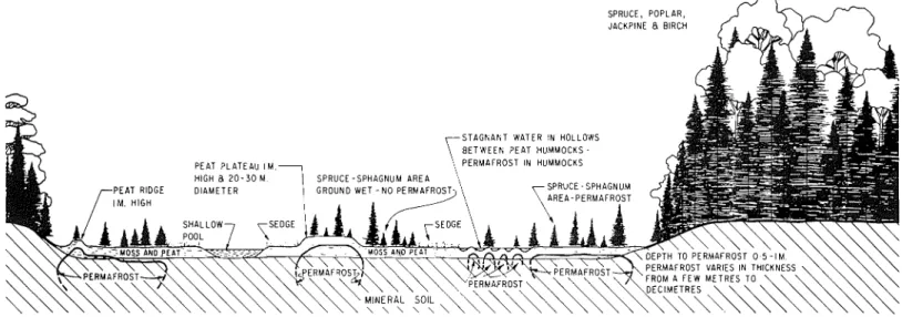
Figure 2. Profile through typicalpeatland in southern fringe of discontinuous zone showing interaction of permafrost and terrain factors ( B R L 83).
tion of peatlands occurs in the discontinuous zone. Second, the occurrence of permafrost in the discontinuous zone is complicated by its patchy distribution in contrast to the continuous zone where permafrost is found everywhere beneath the land surface.
The occurrence of permafrost in peatlands in the southern part of the discontinuous zone appears to be related to changes in the thermal conductivity of the peat through the year (Tyrtikov, 1959; Brown, 1966b). During the summer the surface layers of peat be- come dry through evaporation. The thermal conductivity of the peat is low and warming of the underlying soil is impeded. The lower peat layers gradually thaw downward and become wet as the ice layers in the seasonally frozen layer melt. In the autumn there tends to be more moisture in the surface layers of the peat because of a decreased evaporation rate. When it freezes the thermal con- ductivity of the peat is increased considerably. Thus the peat offers less resistance to the cooling of the underlying soil in winter than to the warming of it in summer. As a result, the mean annual ground temperature under peat will be lower than under adjacent areas without peat. When conditions under the peat are such that the ground temperature remains below O°C throughout the year, permafrost results and is maintained as long as the thermal con- ditions leading to this lower temperature persist.
Such a close relationship exists among the environmental fac- tors in peatland that it is difficult to single out the significant effect of each one on the thermal regime. In the southern fringe of the discontinuous zone, variations in permafrost occurrence are indi- cated by its patchy distribution (Figure 2). The importance of drainage (water conditions) is shown by the absence of permafrost in areas where the water table is at or near the ground surface. Surface water, even between individual small hummocks, inhibits the existence of permafrost between the hummocks but not be- neath them. Permafrost occurs also in other peat features such as plateaux and palsas-a Swedish term for a low hill or knoll in peatland containing permafrost. These features constitute micro- relief of one o r more metres in the peatlands. These elevated fea- tures are relatively well drained compared to the surrounding wet terrain. Variations in snow cover are presumed to be a significant factor in the patchy distribution of permafrost. The summits of palsas and other peat relief features are frequently more exposed to wind, resulting in less snow accumulation and greater frost
sufficiently severe to cause the formation and persistence of per- mafrost despite the thermal effects of the water. The thickness of the active layer is influenced by the water, however, in that the depth to the permafrost table beneath shallow pools is usually greater than in neighbouring micro-relief features.
AIRPHOTO INTERPRETATION OF
PERMAFROST IN PEATLANDS
The recognition on aerial photographs of permafrost occurrences in peatlands is possible where distinctive patterns exist. The largest and most distinctive permafrost features in the southern fringe of the discontinuous zone are peat plateaux and palsas. A typical aerial photograph from the southern fringe of the discontinuous permafrost zone is shown in Figure 3 (see also Figures 4 and 5 ) located in Northern Ontario, about 50 km west of James Bay. The entire area is peatland in which three main patterns are evident:
1) Medium grey with smooth texture covering the central and southwest portions of the photograph on both sides of the stream which flows from west to east. This is a low, wet, poorly drained
penetration than in the surrounding low-lying terrain. Figure 3. Section of Royal Canadian Air Force aerial photograph Northward, in the discontinuous zone and in the continuous A14961-12~ of terrain i n ~i~~~~ 5. Location i n Hudson B~~ ~~~~~~d zone, permafrost becomes widespread and occurs even in the wet 50 km west of James Bay, Northern Ontario, Canada, in southern fringe and poorly drained portions of peatlands. Here the climate is of discontinuous permafrost zone (BR 1591 6).
Figure 4. Small youthful palsas containing permafrost in wet peatland with no permafrost, located at southern limit of discontinuous zone near
south end of James Bay, Canada (BR 14133).
flat sedge area. The black pepper-like flecks are small pools of Figure 6. Section of Royal Canadian Air Force aerial photograph A1 41 88-
11 9 of terrain in Figures 7 and 8. Location near Nelson River, Northern water less than 2 0 m in diameter. N o permafrost occurs in this Manitoba, Canada, i n
northern portion of discontinuous permafrost
pattern. zone (BRM 566).
2) Fine network of closely spaced dark grey t o black flecks in a light grey mesh-like rnat;ix covering the northwest and eastern quarter of the photograph. This is a low, wet, poorly drained and flat area consisting of shallow pools up t o 3 0 o r 4 0 m in diameter separated by low narrow sedge, and moss-covered peat ridges about 0.5 m high. T h e dark grey circular areas in the southeast corner are spruce (Picea sp.) islands 100 m o r more in size. N o permafrost occurs in this pattern.
3 ) Light grey circular and irregularly shaped areas with white patches adjacent t o the stream and bordering Pattern 2 in the southeast portion of the photograph. These areas are large mature palsas 3
-
4 m high and high peat plateaux and coalesced palsas. T h e light grey tone is caused by the dense cover of Labrador tea (Ledum groenlandicum) growing on the lichen cover of the palsas. T h e white patches are lichens (Clndonia sp.). Permafrost occurs in these features. The peat is about 1.5 m thick overlying grey silty clay with sand and small stones. T h e permafrost table is about 7 0 cm below the ground surface and the permafrost is probably about 7-
1 0 m thick.i
In the northern part of the discontinuous zone, surface fea- tures associated with permafrost are more widespread. In some localities, the features with permafrost are quite distinct f r o m those with n o permafrost. Such a situation exists in the northern portion of the discontinuous zone in Northern Manitoba o n t h e Nelson River about 150 km west of Hudson Bay. T h e peatland in this region is a mosaic of peat plateaux interspersed with wet de- pressions (Figures 6, 7, 8). T h e aerial photograph in Figure 6
shows clearly the two main patterns:
1) D a r k grey with small black circular and elongated areas. These are low, flat, wet, grass and sedge-covered depressions with shal- low pools of water. Tree growth is virtually non-existent. On the oblique aerial view (Figure 7) this pattern comprises most of the dark grey smoother textured lower half of the photograph. In t h e ground view (Figure 8) the low wet area in the foreground is typ- ical of this terrain type. Probings and drilling indicate that n o permafrost occurs under these wet depressions and pools. 2) Light grey with small white irregular shaped areas. These are peat plateaux rising 1
-
1.5 m above the level of Pattern 1 coveredFigure 5. Mature peat plateaux formed from coalesced palsas with permafrost on aerial photograph in Figure 3. Note dense coverage of
burned spruce trees, dense Labrador tea and hummocky lichen- and Figure 7. Aerial view from altitude of 150 rn of terrain on aerial photo- Sphagnum-covered peat surface. No permafrost exists in sedge- graph in Figure 6 showing forested peat plateau with permafrost and
Figure 8. Ground view of terrain on aerial photograph in Figure 6 showing forested peat plateaux i n background with permafrost and l o w
wet treeless area in foreground with n o permafrost (BRS 2532).
with dense spruce forest and ground cover of hummocky thick Sphagnum and other mosses, lichens and Labrador tea. On the oblique aerial view (Figure 7) this pattern comprises the coarse- textured upper third of the photograph. I n the ground view (Fig- ure 8) the forested peat plateau in the background is typical of this terrain type. Probings and drilling indicate that permafrost exists in the peat plateaux to a depth of about 2 5 m . T h e active layer varies from about 45
-
60 cm.The identification of features in peatlands containing perma- frost is not always as straightforward as in the two examples cited above. Most palsas are relatively small features and cover very small areas o n all but aerial photographs flown at low levels. Peat plateaux are more extensive and thus more easily discernible. Where peat micro-relief features are absent, the existence of permafrost can only be inferred in relation to visible terrain factors such as drainage. These terrain relationships have to be considered in the broad framework of climate and location of the area in the permafrost region. F o r example, it is very unlikely that permafrost will be found in wet peatland in the southern fringe of the discontinuous zone. Its occurrence is quite probable in similar terrain conditions in the northern portion of the dis- continuous zone, and in the continuous permafrost zone, it will invariably exist.
Attempts have been made to correlate the distribution of permafrost in peat terrain with the occurrence of lichen. Radforth has suggested that lichen (termed the "H factor" in his muskeg classification) is a n indicator of the existence of permafrost in peatlands (Radforth, 1962, 1963a,b, 1966). It was suggested also that lichen can be used effectively as a n indicator t o identify the presence of permafrost in peatlands o n aerial photographs (Kor- pijaako, 1966). These assumptions have been considered in the investigations of permafrost occurrence in Canadian peatlands and proved to be invalid (Brown, 1966a). Lichen is indeed wide- spread in Northern Canada but also proliferates in many peat areas where no permafrost exists as well as being absent from many areas where permafrost occurs.
ORIGIN AND DEVELOPMENT OF
PEAT PLATEAUX AND PALSAS
T h e origin, development and nature of these features have been discussed by several authors in North America and Europe (papers by Brown, Forsgren, Hustich, J. Lundqvist, S. Lundqvist, P'yavchenko, Ruuhijami, Salmi, Svensson, Tyrtikov). I n the vast
peatlands of the Hudson Bay Lowland in Canada, all stages of development can be observed. It appears that peat plateaux and palsas are morphological variations of the same process i.e., the same mechanism is responsible for the formation of both these features, which pass through a life cycle of growth and degrada- tion. Svensson (1961
-
1962) and Tyrtikov (1966) both appear t o support this contention.Initially these features appear as low mounds o r upwarpings of peat protruding above water level in the middle of shallow ponds less than about 1 m in depth (Figure 4). T h e mechanism of their formation and control of their distribution is uncertain, but it is suggested that the ponds freeze to the bottom in winter and the underlying saturated peat is domed up at random locations by intensive frost action and ice lens growth. When elevated above the pond level, the dry layer of exposed peat insulates the under- lying frozen mass from summer thawing thus marking the initia- tion of a perennially frozen o r permafrost condition. T h e elevation of the peat surface above the general level of the surrounding flat level surface devoid of relief exposes it to winter winds which re- duce o r remove the insulating snow cover. Winter frost penetra- tion is therefore greater than in the surrounding low, flat areas, which contributes to further permafrost accumulation.
As the peat continues to accumulate year after year accom- panied by the increase in permafrost thickness each winter, the mounds grow and coalesce to form ridges and plateaux. I n the youthful stage there is little or no living vegetation on the peat surface. During maturity, Sphagrzurn and other mosses and lichens become established along with Labrador tea and spruce (Figure 5 ) . Old age and degradation begin when the insulating ground cover ruptures due to biological oxidation and general deteriora- tion, and thawing penetrates into the underlying perennially frozen core. T h e surface of the palsa or peat plateau becomes very uneven because of differential thawing of the underlying ground ice and large blocks of thawed peat break off the margins. It is not certain whether rejuvenation can occur.
T h e critical factors in palsa and peat plateau formation are possibly climate, snow cover and water supply. Little work has been done on the climatic requirements f o r the formation of these features but some information is available in the Scandinavian literature. It has been recorded in Sweden that palsas occur where the air temperature remains below O°C during more than 200 days per year. They also appear to be present only where the precipitation during the period of November to April is less than 300 m m (Lundqvist, 1962). It appears from the air temperature and precipitation data for the permafrost region of Canada that these criteria are satisfied. I n Canada, palsas are much more pre- valent in the Hudson Bay Lowland than the other physiographic regions. Peat plateaux occur extensively in peatlands of all the regions.
Snow cover is considered one of the critical terrain factors in palsa development once formation of the future has begun: As mentioned above by Lundqvist, the amount of snowfall in the region through the winter may not exceed a certain quantity. I n addition, snow accumulation o n palsa summits is significantly less than o n the surrounding terrain, because of their exposed position to wind and this results in great frost penetration. Winter obser- vations have not been made in the Hudson Bay Lowland o r else- where in Canada t o test the validity of these assumptions.
Drainage conditions and water supply are very important fac- tors in the development of palsas and peat plateaux. T h e ponds in which they begin t o grow should be sufficiently shallow t o freeze to the bottom so that a frozen zone may develop below. T h e pro- cess of growth is not clear but the gradual updoming of the peat proceeds possibly because of its high capillarity, which draws con- siderable quantities of water t o the freezing front from the sur- rounding wet areas. These conditions occur widely in the Hudson
Bay Lowland, where palsas and coalescing palsas forming peat plateaux grow to heights of 4
-
5
m. The lower peat plateaux which occur extensively in the Hudson Bay Lowland and in peatlands in the other physiographic regions may be limited in height for several reasons. There may be less water available for ice accum- ulation. The dense tree growth tends to reduce exposure to wind and to encourage snow accumulation which reduces frost pene- tration.One regional variation of palsas which has received little at- tention is that mature palsas in the Hudson Bay Lowland and elsewhere in Canada west of Hudson Bay support a dense forest growth, in contrast to mature palsas east of Hudson Bay and in Northern Scandinavia, which are generally devoid of tree growth. This difference may be related to the more continental climate conditions prevailing in Canada west of Hudson Bay. The vege- tation of many mature palsas in the Hudson Bay Lowland has been burned over by forest fires, but this appears to have little influence on the permafrost because only the top 1 or 2 cm of the peat is affected.
VARIATIONS
ZN
PHYSIOGRAPHIC REGIONS
Mention has been made of the high concentration of peatland occurrence in Hudson Bay Lowland compared with the other much larger physiographic units in the permafrost region of Canada. Virtually all of the Hudson Bay Lowland is comprised of peatland except the banks of the major rivers. Permafrost varies from a very patchy occurrence in the south to continuous in the north. Peat plateaux and palsas in all stages of development abound in this region. In the discontinuous zone, no permafrost is found in the wet fens which comprise most of the peatland. In the narrow strip of continuous permafrost on the Hudson Bay Coast, permafrost occurs everywhere beneath the ground surface.
In the Precambrian Shield, peatlands are much less extensive, being comprised mostly of confined bogs in rock basins. A n excep- tion to this pattern is the existence of extensive peatland east and north of Lake Winnipeg in the glacial Lake Agassiz plain. String bogs are widespread throughout the Shield; their occurrence is
attributed to the underlying acidic rocks. The existence of perma- frost in these features in the discontinuous zone, as in the pattern- ed fen in the Hudson Bay Lowland, is inhibited because they are too wet, but permafrost occurs in them in the continuous zone. Permafrost occurrence varies from south to north in the same manner as in the Hudson Bay Lowland. Palsas are much less numerous but peat plateaux are widespread. In the southern fringe of the discontinuous zone, permafrost islands in peatlands are less numerous in Quebec than west of Hudson Bay possibly because of the higher snowfall.
Extensive peatlands occur in some areas of the Interior Plains. I n Northern Alberta and Northeastern British Columbia, for ex- ample, tracts of peat terrain extend over several tens of square kilometres. Very few palsas have been noted in these areas but peat plateaux with permafrost are widespread. Although these peatlands resemble the Hudson Bay Lowland more than the Pre- cambrian Shield, their permafrost features are more similar to those in the latter region.
Peat terrain in the Cordillera is mostlv confined to rock basins. The mountainous relief causes variations in permafrost occur- rence with elevation in addition to the usual latitudinal changes. The occurrence of permafrost in the peat areas depends on the elevation as well as on the latitude. Like the two previous regions, palsas are infrequent but peat plateaux are common. I n the northern part of the discontinuous zone, permafrost is found even in wet swampy areas.
The Arctic Archipelago actually comprises three regions, the Arctic Lowlands and Plateaux, Innuitian Region, and the northern part of the Precambrian Shield, but in this paper it is considered as one region. It lies entirely within the continuous permafrost zone except possibly the southeast tip of Baffin Island. Fairly ex- tensive peatlands occur in the interiors of some of the islands and string bogs have been noted in some areas. Permafrost is found everywhere beneath the ground surface in these areas, regardless of drainage conditions.
Measurements of peat thickness and depth of active layer have been carried out in the southern fringe of the permafrost region
TABLE I
Peat and Active Layer Thickness by Physiographic Regions i n Southern Fringe of Discontinuous Permafrost Zone i n Canada
-- -
Peat
Average Minimum and No. of observations
Physiographic No. of Av. thickness, deviation, maximum observed where peat
Region observations c m c m (per cent) thickness, c m thickness
>
2 mPrecambrian Shield 139 1 3 2 + 6 4 (48) 2 3 - 3 6 6 3 5
Hudson Bay Lowland 3 0 1 4 5 +71 (49) 8 - 3 1 0 1 0
Interior Plains 223 8 9 +41 (46) 5 - 282 21
Cordillera 6 2 53 + 3 6 (68) 8 - 206 1
Total 454 67
Active Layer
Position of permafrost table i n relation t o peat layer - number of observations Physiographic
Region
No. of Av. thickness Average deviation, A t peat-mineral Below peat
observations cm cm (per cent) I n peat layer soil interface layer
Precambrian Shield 7 0
Hudson Bay Lowland 1 4
Interior Plains 1 0 9
Cordillera 3 4
in all physiographic regions except the Arctic Archipelago. Some results of these measurements are presented in Table I. Although the number of observations varies considerably from one physio- graphic region to another, some generalizations are evident. The thickest peat occurs in the Precambrian Shield and Hudson Bay Lowland and the proportion of observations in peat exceeding a thickness of 2 ni in these two regions greatly exceeds the propor- tion in the other two regions. T h e average percentage deviation of the peat thickness measurements is similar in three regions and higher in the Cordillera. The thickest measured peat deposits of 366 c m and 3 10 cm were encountered in the Precambrian Shield and Hudson Bay Lowland respectively, although greater thick- nesses occur in all regions. The generally greater thickness of peat in the Precambrian Shield may be related to the existence of many rock basins in which peat can accumulate to considerable depths. In the Hudson Bay Lowland, the maritime climate with cool summers combined with poor drainage over vast expanses contribute to considerable peat accumulation.
Although peat thicknesses vary considerably from one physio- graphic region to another, the thickness of the active layer, o r depth to the permafrost table, is fairly uniform. T h e thinnest active layer occurs in the Hudson Bay Lowland and average thicknesses are similar in the other three regions. T h e average percentage deviation is similar in all four regions and much lower than the deviations observed in peat thickness. Active layers are generally thinner in the Hudson Bay Lowlands, prob- ably because of cooler summers and accompanying lower thaw- ing index values compared to the other three more continentally situated regions. Although the Arctic Archipelago is not con- sidered here, the active layer is generally about one-half as thick, because of the much cooler summers, being roughly 20 - 30 cm. T h e insulating properties of the peat are manifested by the fact that the permafrost table occurs usually in the peat layer and not beneath it. Of the 227 locations in which permafrost was en- countered, the permafrost table occurred in the peat layer in 190 (88 per cent), at the peat-mineral soil interface in 14, and in the underlying mineral soil in 23.
CONCLUSIONS
In Northern Canada, peatlands and permafrost are very closely related, especially in the southern fringe of the permafrost region. The distribution of permafrost and its thermal regime in this fringe are governed to a considerable extent by the thermal pro- perties of the peat. Mapping the distribution of permafrost in peatlands is facilitated t o some extent by the occurrence of it in such distinctive microrelief features as peat plateaux and palsas. It is frequently difficult to identify these features on aerial photo- graphs because they are usually small and varied in shape, and many variations occur in photographic tone and texture. Once recognized, they are fairly reliable indicators of the existence of permafrost. Some differences in the occurrence of permafrost in peatlands appear to exist among the various physiographic regions but more observations are required before conlpletely reliable correlations c a n be made.
REFERENCES
Brown, R. J. E. 1966. Permafrost, climafrost and the muskeg H factor. Proc. Eleventh Muskeg Res. Conf., National Research Council of Canada, Assoc. Comm. on Geotech. Res., Tech. Memo. 87, p. 159-178.
1966b. The influence of vegetation on permafrost. Proc. Inter. Conf. on Permafrost. U.S. National Academy of Sciences, National Research Council, Washington, D.C. Public. No. 1287, p. 20-25.
1967. Permafrost map of Canada. Division of Building Research, National Research Council of Canada, NRC 9769, and Geological Survey of Canada, Map 1246 A.
Permafrost investigations in northern Ontario and north- eastern Manitoba. National Research Council of Canada, Division of Building Research Technical Paper. (In press.)
Forsgren, B. 1964. Notes on some methods tried in the study of palsas. Geografiska Annaler, 46:3 : 343-344.
1965. Tritium determination in the study of palsa formation. Geografiska Annaler, 48A:2: 102-1 10.
Hustich, I. 1957. On the phytogeography of the subarctic Hudson Bay Lowland. Acta Geographica Fenn. 16: 1 : 1-48.
Kats, N. Ya. 1958. Distribution of bog types in frigid and temperate zones of the Northern Hemisphere. Soviet Soil Science, No. 6, p. 599-605.
1961. Bogs and peats of North America. Soviet Soil Science, NO. 10, p. 1165-1171.
Korpijaakko, E., and N. W. Radforth. 1966. Aerial photographic interpretation of muskeg conditions at the southern limit of permafrost. Proc. Eleventh Muskeg Res. Conf., National Research Council of Canada, Assoc. Comm. on Geotech. Res., Tech. Memo. 87, p. 142-151.
Lundqvist, J. 1965. Earth and ice mounds-a terminological dis- cussion. Inter. Assoc. for Quaternary Research (INQUA), Alaska Symposium on Cold Climate Processes and Environments. Lundqvist, S. 1962. Patterned ground and related frost phenomena
in Sweden. Sveriges Geol. Undersokn, C583.
and J. 0. Mattsson. 1965. Studies on the thermal structure of a palsa. Lund Studies in Geography, Ser. A. Physical Geography. No. 34, The Royal Univ. of Lund, Sweden, Dept. of Geography, p. 38-49.
P'yavchenko, N. I. 1955. Bugristye torfyaniki (Hummocky peat bogs). Akademiya Nauk SSSR, Institut Lesa (Academy of Sciences of the USSR, Forestry Institute), Moscow, 278 p. (In Russian.)
Radforth, N. W. 1961. Distribution of organic terrain in northern Canada. Proc. Seventh Muskeg Res. Conf., National Research Council of Canada, Assoc. Comm. on Soil and Snow Mech., Tech. Memo. 71, p. 8-11.
1962. Organic terrain and geomorphology. Can. Geographer, VI, 3-4:166-171.
1963a. The ice factor in muskeg. Proc. First Can. Conf. on Permafrost, National Research Council of Canada, Assoc. Comm. on Soil and Snow Mech., Tech. Memo. 76, p. 57-78.
1963b. A classification system for organic terrain and its application. Proc. Atlantic Provinces Regional Seminars on Organic Terrain Problems, National Research Council of Canada, Assoc. Comm. on Soil and Snow Mech., Tech. Memo. 77, p. 37-44.
1966. Origin and significance of organic terrain features. Proc. Inter. Conf. on Permafrost, U.S. National Academy of Sciences, National Research Council, Washington, D.C., Public. No. 1287, p. 38-43.
Ruuhijarvi, R. 1960. tiber die Regionale Einteilung der Nord- finnischen Moore (Regional distribution of north Finnish bogs). Annales Botanici Societatis Zoologicae Botanicae Fennicae 'Vanamo', vol. 31, No. 1, Helsinki, 360 p. (In German.) Salmi, M. 1966. Investigations on palsa in Finnish Lapland.
UNESCO Symposium on Ecology of Subarctic Regions, Helsinki. Sjors, H. 1969. Bogs and fens in the Hudson Bay Lowlands. Arctic,
12(1):3-19.
1959a. Forest and peatlands at Hawley Lake, northern Ontario. National Museum of Canada, Contributions to Botany, Bull. 171, p. 1-31.
1959b. Surface patterns in Boreal peatlands. Endeavour XX(80) 3217-224.
Svensson, H. 1961-1962. NIgra Iakttagelser frin Palsomriden Flygbildanalys och Faltstudier: Nordnorska Frostmarksomriden) (Observations on palsas-photographic interpretation and field studies in northern Norwegian frost ground areas). Norsk Geografisk Tidsskrift Bd. XVIII, H. 5-6, p. 212-227. (In Norwegian.)
1964. Structural observations in the minerogenic core of a palsa. Sartryck FrIn Lunds Universitets Geografiska Institution. NO. 17, p. 138-142.
1966. Frozen ground morphology of north easternmost Norway. UNESCO Symposium on Ecology of Sub-Arctic Regions, Helsinki.
Tyrtikov, A. P. 1959. Perennially frozen ground and vegetation. In Principles of Geocryology. Edited by P. F. Shvetsov, Academy of Sciences of the USSR, vol. I, p. 399-421. National Research Council of Canada, Tech. Transl. No. 1163, 1964.
1966. Formirovaniye i razvitiye krupnobugristykh torfyanikov v severnoy tayge zapadnoy sibire (Formation and development of large hummocky peat bogs in the northern taiga of western Siberia), Merzlotnyye Issledovaniya (Permafrost Investigations), vol. VI, p. 144-154. (In Russian.)