HAL Id: hal-02890207
https://hal.archives-ouvertes.fr/hal-02890207
Submitted on 5 Nov 2020HAL is a multi-disciplinary open access archive for the deposit and dissemination of
sci-L’archive ouverte pluridisciplinaire HAL, est destinée au dépôt et à la diffusion de documents
The role of climate-fuel feedbacks on Holocene biomass
burning in upper-montane Carpathian forests
Vachel Carter, Přemysl Bobek, Alice Moravcová, Anna Šolcová, Richard
Chiverrell, Jennifer Clear, Walter Finsinger, Angelica Feurdean, Ioan Tanţău,
Enikö Magyari, et al.
To cite this version:
Vachel Carter, Přemysl Bobek, Alice Moravcová, Anna Šolcová, Richard Chiverrell, et al.. The role of climate-fuel feedbacks on Holocene biomass burning in upper-montane Carpathian forests. Global and Planetary Change, Elsevier, In press, pp.103264. �10.1016/j.gloplacha.2020.103264�. �hal-02890207�
The role of climate-fuel feedbacks on Holocene biomass burning in upper-montane Carpathian
1
forests
2 3
Authors- Vachel A. Carter1*, P em sl Bobek2, Alice Moravcová1, Anna olco 1,2, Richard C.
4
Chiverrell3, Jennifer L. Clear4,5, Walter Finsinger6, Angelica Feurdean7,8,9, Ioan Tan 9, Enik
5
Magyari10, 11, 12, Tom Brussel13, Pe r K ne 1
6
1 Department of Botany, Faculty of Science, Charles University, Prague, Czech Republic
7
2 Ins i e of Bo an , The C ech Academ of Sciences, Pr honice, C ech Rep blic
8
3 Department of Geography and Planning, University of Liverpool, Liverpool, United Kingdom
9
4 Department of Geography and Environmental Science, Liverpool Hope University, Liverpool,
10
United Kingdom
11
5 Department of Forest Ecology, Czech University of Life Sciences, Prague, Czech Republic
12
6 ISEM, University Montpellier, CNRS, EPHE, IRD, Montpellier, France
13
7 Department of Physical Geography, Goethe University, Altenhöferallee 1, 60438 Frankfurt am
14
Main, Germany,
15
8 Senckenberg Biodiversity and Climate Research Centre (BiK-F), Senckenberganlage, 25,
16
60325, Frankfurt am Main, Germany
17
9 Depar men of Geolog , Babe -Bolyai University, 400084 Cluj-Napoca, Romania
18
10 Department of Environmental and Landscape Geography, Eötvös Loránd University,
19
Budapest, Hungary
20
11 MTA-MTM-ELTE Research Group for Paleontology, Budapest, Hungary
21
12 GINOP Sustainable Ecosystems Group, MTA Centre for Ecological Research, Tihany,
22
Hungary
23
13 Department of Geography, University of Utah, Salt Lake City, Utah, USA 24 25 Correspondence: 26 Dr. Vachel A. Carter 27 vachel.carter@gmail.com 28 29
Revised manuscript for Global and Planetary Change
30
Highlights
31
First high-resolution Holocene fire record from the High Tatra Mountains, Western
32
Carpathians.
33
Biomass burning in upper-montane Carpathian forests is influenced by forest
34
composition and forest density, both of these are strongly-dependent on climate.
35
Despite the reduced risk of fire implicit in Picea abies forests, biomass burning continued
36
in forests with an intermediate forest cover, while fires with too dense of forest cover
37
experienced less biomass burning.
38
Future climate change may create a positive climate-fuel feedback, linking
upper-39
montane forests with more Pinus cover to biomass burning.
40 41
Abstract
42
Over the past few decades, mean summer temperatures within the Carpathian Mountains have
no paleofire records from the Western Carpathians that provide the long-term range of natural
45
variability to contextualise the response of upper-montane forests to future environmental change
46
and disturbance regimes. We present the first high-resolution Holocene fire history record from
47
the upper-montane ecotone from the High Tatra Mountains, Slovakia, as well as provide a
48
regional synthesis of pan-Carpathian drivers of biomass burning in upper-montane forests. Our
49
results illustrate that forest composition and density both greatly influence biomass burning in
50
these hotspots for biodiversity, creating two different climate-fuel feedbacks. First, warmer
51
conditions occurred in the early Holocene, coupled with generally higher abundances of Pinus
52
sp., either P. cembra and P. mugo, created a positive climate-fuel relationship that resulted in
53
higher amounts of biomass burning. Second, cooler and wetter late Holocene conditions led to
54
denser Picea abies upper-montane forests, creating a negative climate-fuel feedback that reduced
55
biomass burning in upper-montane forests across the Carpathians. Given that warmer and drier
56
conditions are expected across the entire Carpathian region in the future, our results illustrate
57
how future climate change could potentially create a positive climate-fuel relationship within
58
upper-montane forests dominated by Picea abies and Pinus cembra and/or P. mugo.
59 60
Keywords
61
Fire; Upper-montane; Carpathians; Holocene; Sedimentary charcoal; Pollen; Macrofossils; Picea
62
abies; forest composition; forest density
63 64
1 Introduction
65
Mountain forests are important ecosystems providing an array of ecosystem goods and
66
services, with roughly half of the global human population depending upon these services
(Körner and Ohsawa, 2005). Mountain forests are also key hotspots for biodiversity, with higher
68
levels of endemic richness as a result of high environmental heterogeneity and geographic
69
isolation (Noroozi et al., 2018). In Europe, forests cover 41% of the total mountain area with the
70
majority of forest cover occurring in the Alps, Carpathians and Pyrenees Mountains (Price et al.,
71
2011). Unfortunately, mountain forests are among the most sensitive ecosystems to climate
72
change, with high mountain environments experiencing more rapid changes in temperature than
73
low-elevation environments (Pepin et al., 2015). Since 2001, all major European alpine systems
74
have witnessed an increasing trend in warm-adapted species (Gottfried et al., 2012), illustrating
75
their sensitivity to warmer temperatures. Given that climate influences significantly the structure,
76
composition and function of high mountain ecosystems (Prentice et al., 1992), climate-induced
77
changes are likely going to be more pronounced near the upper treeline (Harsch et al., 2009).
78
Norway spruce (Picea abies) is one of the most important economic trees in Europe,
79
dominating the boreal forests in northern Europe and upper-montane/subalpine areas of the Alps
80
and Carpathian Mountains (hereafter referred to as Carpathians) (Caudullo et al., 2016). Norway
81
spruce is susceptible to both heat and drought due to its shallow root systems and may be
82
vulnerable to the increasing temperatures at high-elevations. In fact, Picea abies is currently
83
listed as one of the most vulnerable tree species in the Carpathians due to increasing summer
84
temperatures (Linder et al., 2008), with both montane (1100 1500 m a.s.l) and subalpine (>1500
85
m a.s.l.) Picea abies forests projected to decline in extent with climate change (Werners et al.,
86
2014). Mean summer temperatures in the Carpathians have increased by as much as 2 oC over
87
the past few decades (Alberton et al., 2017), twice the global mean (Auer et al., 2007), which
88
raises the prospect of greater sensitivity to climate change than montane forests elsewhere in
89
Europe (UNEP, 2007). This sensitivity to climate change will likely propagate through the 21st
century, with mean summer temperatures projected to increase by a further 1 2 oC across the
91
Carpathians by the end of the century (Anders et al., 2014) in conjunction with heat waves and
92
droughts. Projected changes in precipitation across the Carpathians are more varied but suggest
93
greater seasonality with generally drier summers (Anders et al., 2014). If conditions continue as
94
projected, drier conditions could lead to either a collapse and/or dieback of Picea abies,
95
compromising the provision of ecosystem services (Lévesque et al., 2013).
96
Many mountains forests including old growth Picea abies forests are declining and/or
97
vanishing, especially within the Romanian arc of the Carpathians as a result of deforestation,
98
poor management practices, and increased rates of forest disturbances linked to windthrow, bark
99
beetle outbreak and fire events (Achard et al., 2009; Hlásny and Sitková, 2010; Feurdean et al.,
100
2011; Knorn et al., 2012; 2013; Temperli et al. 2013; Grindean et al., 2019). These factors
101
illustrate the sensitivity of Picea abies forests to human intervention, disturbance regimes, and
102
climate change. Given that there is a high likelihood of increased fire risk among central and
103
southern European ecosystems by the end of the 21st century(Lung et al., 2013), and that air
104
temperature is a key variable for establishment and growth of high mountain forests (Körner and
105
Paulsen, 2004), the coupled threat of future climate change and increased likelihood of fires
106
potentially threatens upper-montane Picea abies forests across the Carpathians. This threat could
107
affect their ability to provide ecosystem services (Albrich et al., 2018), including negative
108
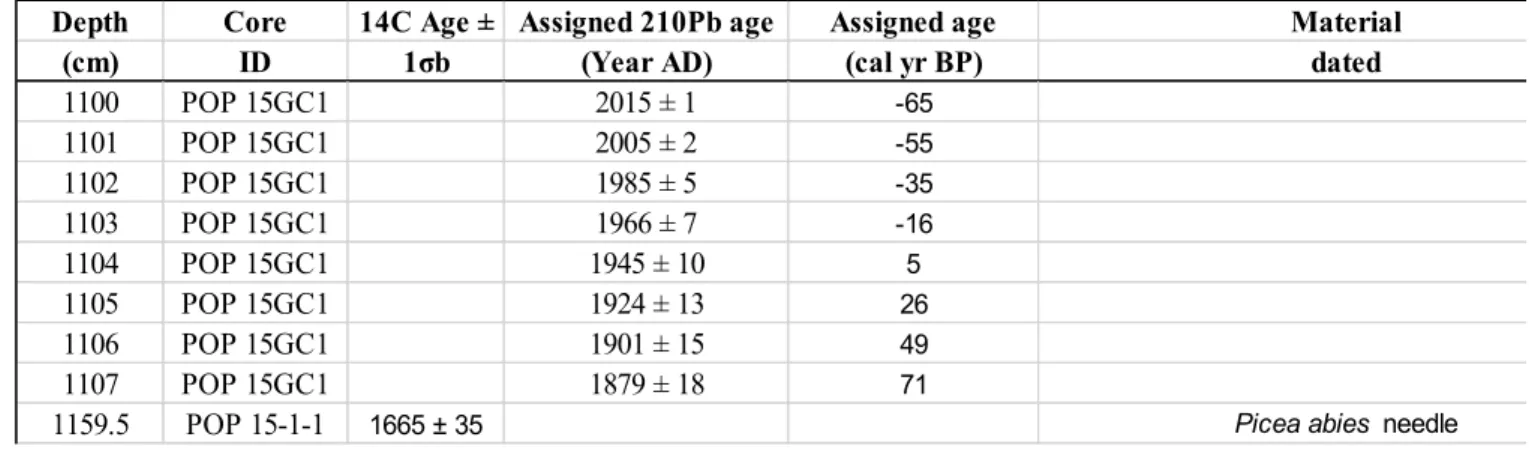
impacts on key transboundary biosphere reserves (UNESCO-WNBR). However, there is
109
currently a limited understanding regarding the long-term importance of fire in high mountain
110
forests, specifically upper-montane Picea abies-dominated forests. This information is critical
111
for conservation and management as Picea abies is also highly susceptible to other forest
112
disturbances such as windthrow and bark beetle outbreaks. What limited understanding we have
about fire activity in upper-montane forests throughout the Carpathians is from research mostly
114
from the Eastern and Southern Carpathians, which demonstrate the importance of long-term fire
115
occurrence these elevations (Gean e al., 2014; Feurdean et al., 2012; 2017; Finsinger et al.,
116
2018; Florescu et al., 2018). No long-term records of fire dynamics existed from the Western
117
Carpathians until recent research, which is from the lower montane forest zone dominated by
118
beech (Fagus sylvatica), silver fir (Abies alba), and an admixture of Norway spruce (Ko ac ek e
119
al., 2020).
120
Here, we present a new c.9500-year high-resolution paleoecological record from
121
Popradské pleso located in the upper-montane forest zone in the High Tatra Mountains,
122
Slovakia, Western Carpathians. We address the existing knowledge gap concerning the
long-123
term history of fire in upper-montane forests in the Western Carpathians by comparing the new
124
record with other high-resolution fire records from the upper-montane forest zone spanning the
125
entire Carpathian region. Our objectives are to; 1) quantify the long-term variability in wildfire
126
(biomass burning) regime and assess spatial differences across the wider Carpathian
upper-127
montane forested ecosystem; 2) evaluate the respective roles of climate and humans as drivers of
128
past biomass burning; 3) explore how forest composition and density modulates biomass burning
129
in these upper-montane forest ecosystems; and 4) use the paleofire record to infer the potential
130
impacts of future climate warming (1 2 oC). Our study provides critical data for understanding
131
the role of fire disturbance regimes in old growth spruce forests in the Carpathians, with utility
132
for understanding the future dynamics of equivalent montane ecosystems elsewhere.
133 134
2 Study region
135
2.1. Popradské pleso in the Western Carpathians
Popradsk pleso (pleso is Slo ak for glacial lake ) (49 09 13 N, 20 04 47 E, 1513 m
137
a.s.l.) is located in the Mengusovská dolina valley, on the south slope of the central High Tatra
138
Mountains (Figure 1). The High Tatra Mountains are a west-to-east trending mountain range
139
along the Slovakia-Poland border situated within the Western Carpathians. This mountain range
140
was heavily glaciated during the Last Glacial Maximum with the Mengusovská dolina valley
141
hos ing he larges glacier on he so h slope (Zasadni and K ap a, 2014). Popradsk pleso has a
142
large catchment to lake area ratio (67.5:1), and a maximum water depth of ~18 m with a surface
143
area of ~6.3 6.9 ha (Schaffer and Stummer, 1933; Pacl, 1973). The lake catchment has a
granite-144
granodiorite bedrock and is surrounded by the tallest mountain peaks in the entire High Tatra
145
region including the tallest mountain peak, Rysy (2500 m a.s.l.). The lake has one inflowing
146
s ream, ado po ok, on he nor heas side, and one o flo s ream, Kr p , on he so h side.
147
Popradské pleso is located ~50 m downhill from the upper treeline in the upper-montane
148
forest belt (Grod i ska e al., 2004), hich is domina ed b Nor a spr ce with an admixture of
149
Swiss stone pine (Pinus cembra) and dwarf mountain pine (Pinus mugo). While beech (Fagus
150
sylvatica) and Silver fir (Abies alba) are both common at these elevations in the Southern
151
Carpathians, F. sylvatica is currently absent and A. alba is very rare at these elevations in the
152
High Ta ras (R bn ko and R bn ek, 2006). Ho e er, F. sylvatica is present at lower
153
ele a ions near rbsk Pleso (1358 m; see K era, 2012 and Flachbart, 2007).
154
Climate in the high Western Carpathian mountain zone is cold and moist, with the
155
highest quantities of precipitation (2000 to 2400 mm yr-1) in the Carpathians occurring in the
156
High Tatra Mountains (UNEP, 2007). Mean annual temperature and precipitation from the
157
closes me eorological s a ion o Popradsk pleso, rbsk Pleso, are 3.7 °C and 1826 mm
158
(Slovak Hydrometeorological Institute), respectively. The local west-to-east mountain
orientation has resulted in a strong windward/leeward precipitation gradient with the north side
160
receiving more precipitation than the south site (Koncek, 1974). Mean annual temperatures range
161
between 2 to -4 oC in the coniferous belt dominated by Picea abies forests (Hess, 1965; 1974).
162
For the High Tatras, climate models suggest 2 oC warming alongside 5 8% decreases in summer
163
precipitation, with ~10 15% increases in winter precipitation by the end of 21st century (Anders
164
et al., 2014).
165 166
2.2. Eastern and Southern Carpathian study sites
167
Poiana iol (47o35 14 N; 24o48 43 E, 1540 m a.s.l.; Fe rdean e al., 2017) and T l
168
Muced (47o34 26 N; 24o32 42 E, 1360 m a.s.l.; Feurdean et al., 2017) are both located in the
169
Rodna National Park and Biosphere Reserve, Eas ern Carpa hians. Poiana iol is a nutrient-poor
170
fen located at the current treeline ecotone dominated by Picea abies, Pinus mugo, P. cembra and
171
Juniperus communis ssp. nana (Tan e al., 2011; Fe rdean e al., 2016). The surrounding
172
forest is composed of ~80% Picea abies and ~20% Abies alba (Topographic Maps of Romania,
173
1986). T l M ced is an ombro rophic bog within a closed conifer forest, with onsite woody
174
vegetation consisting of Picea abies with P. mugo. The surrounding forest is comprised of ~40%
175
Picea abies and Abies alba and ~10% Fagus sylvatica (Topographic Maps of Romania, 1986).
176
The clima e a Poiana iol is slightly e er han a T l M ced d e o i s higher al i de (1300
177
mm and 1200 mm, respectively). Mean annual temperature is 2 2.2 °C at both sites (Drago and
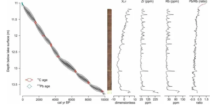
178
Kucsicsa, 2011). For the Southern Carpathians, climate models suggest 2 oC warming alongside
179
10 15% decreases in summer precipitation, with ~10 15% increases in winter precipitation by
180
the end of 21st century (Anders et al., 2014).
Lake Brazi (45o23 47 N; 22o54 6 E, 1740 m a.s.l.; Magyari et al., 2012) is a small
182
(~0.4 ha), shallow lake (maximum water depth 1.1 m), located in the Retezat National Park,
183
Retezat Mountains, Southern Carpathians. The site is located about 110 m below the timberline
184
in a mixed conifer forest dominated by Picea abies and Pinus cembra, with P. mugo being
185
restricted to the floating Sphagnum bog found along the lakeshore. Annual precipitation ranges
186
between 900 and 1800 mm, while the mean annual temperature is around 6 °C in the foothill
187
zone and -2 oC at 2500 m a.s.l. in the Retezat Mountains (Bogdan, 2008). For the Southern
188
Carpathians, climate models suggest 2 oC warming alongside a 10 15% decrease in summer
189
precipitation and a ~2 5% decrease in winter precipitation by the end of 21st century (Anders et
190 al., 2014). 191 192 3 Methods 193 3.1 Field work 194
In September 2015, a 28 cm (POP 15-GC1) and a 4 m-long core (POP 15 1, drives 1 4)
195
were extruded using a floating platform from the centre of Popradské pleso (water depth, 11 m).
196
The sediment water interface was collected using a short gravity corer (Boyle, 1995), while a
197
Russian corer was used to collect the long-core sediments in 1.5 m overlapping sections.
198
Sediments were stored under refrigeration until they were subsampled at high-resolution
199
(contiguous 0.5 cm intervals) for dating and geochemical analyses.
200 201
3.2 Lead 210 and radiocarbon dating
202
A total of 12 Accelerator Mass Spectrometry (AMS) radiocarbon (14C) ages and a
203
radiometric 210Pb series were obtained to construct an age-depth model for Popradské pleso
(Table 1). Most 14C ages were measured on terrestrial plant macrofossils, but in the section
205
below 1371 cm below the water surface, ages were measured on bulk pollen concentrations
206
because of the lack of macrofossils. Pollen extractions for bulk pollen concentrations were
207
modified after Brown et al. (1989) using a dilute Schulze solution of 10% KClO3 and 35% HNO3
208
(Gray, 1965).
209
Radiometric dating targeted the upper 8 cm of the gravity core (POP-15-GC1), analysing
210
for 210Pb, 226Ra, 137Cs and 241Am by direct gamma assay in the Liverpool University
211
Environmental Radioactivity Laboratory using Ortec HPGe GWL series well-type coaxial low
212
background intrinsic germanium detectors (Appleby et al. 1986). 210Pb was determined via its
213
gamma emissions at 46.5 keV, and 226Ra by the 295 keV and 352 keV-rays emitted by its
214
daughter radionuclide 214Pb following 3 weeks storage in sealed containers to allow radioactive
215
equilibration. 137Cs and 241Am were measured by their emissions at 662 keV and 59.5 keV
216
respectively. The absolute efficiencies of the detectors were determined using calibrated sources
217
and sediment samples of known activity. Corrections were made for the effect of self-absorption
218
of low energy-rays within the sample (Appleby et al. 1992).
219
Age-depth relationships were modeled in a Ba esian frame ork sing BACON
220
(Blaauw and Christen, 2011), including both the 210Pb and 14C dates. All 14C dates were
221
calibrated using the IntCal13 dataset (Reimer et al., 2013).
222 223
3.3 Lithostratigraphy, magnetic susceptibility and geochemical analyses
224
Prior to subsampling, high resolution digital line-scan photographs of the Pop15-1 core
225
were taken using the University of Liverpool Geotek Multi-sensor core logger (MSCL-XZ).
226
Geochemical data were determined non-destructively on a wet sediment basis at 5 mm resolution
using an Olympus Delta ED-XRF (4 W) mo n ed o he Geo ek. Cores ere meas red nder Soil
228
mode (40 kV, 40 kV (fil ered) and 15 kV beam in ensi ies) for hea ier elemen s and MiningPl s
229
mode (40 kV and 15 kV) for ligh er elemen s. Each beam in ensity ran for 20 seconds with total
230
runs of 60 seconds (soil mode) and 40 seconds (mining plus). The Olympus XRF instrument is
231
subject to daily consistency checks and regular testing using library of certified geochemical
232
reference materials (Boyle et al., 2015). Element concentrations are expressed in ppm, but are
233
subject to possible matrix effects induced by variable down-core water and organic content
234
arising from measuring wet sediments. Magnetic susceptibility (XLF) was measured on a wet
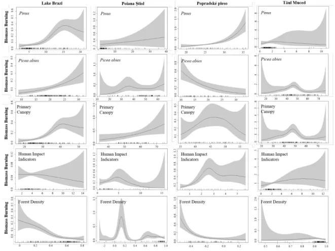
235
sediment basis at 5 mm intervals using a Bartington Instruments MS2E high resolution point
236
sensor paired to the Bartington MS3 meter mounted on the Liverpool Geotek MSCL-XZ. The
237
scan XLF data reveal changes between minerogenic (positive values) and organic or high-water
238
content sediments (negative or diamagnetic values).
239 240
3.4 Plant macrofossils and pollen analysis
241
Pollen analysis was conducted contiguously at 1 cm resolution throughout the gravity
242
core, and at 2.5 cm resolution throughout the long core from Popradské pleso. Pollen processing
243
utilized standard acid-base rinse procedures (Faegri et al., 1989) using 0.5 cm3 of sediment per
244
sample. A Lycopodium tablet was added to each sample prior-to pollen processing, and was used
245
as an exotic tracer to calculate both pollen concentration (grains cm3) and pollen accumulation
246
rates (pollen influx; grains cm-2 yr-1) (Stockmarr, 1972). A minimum of 500 terrestrial pollen
247
grains were identified at a magnification of 400× with the aid of reference material and
248
identification keys (Beug, 2004; Punt, 1976 1996). Pollen counts were converted into pollen
249
percentages based on the abundance of each pollen type relative to the sum of all identified
terrestrial pollen. The pollen profile was divided into pollen assemblage zones based on optimal
251
splitting by sums-of-squares using the broken-stick model using the software, Psimpoll (Birks
252
and Gordon, 1985; Bennett, 1996). Legacy pollen data from the wider Carpathian region were
253
a ailable from Poiana iol, T l M ced and Lake Bra i (see Mag ari e al., 2012; Tan e al.,
254
2011; Grindean et al., 2019). To access changes in forest density, we calculated an index using
255
the ratio of Picea abies pollen (a) to Pinus pollen (b) following Higuera et al. (2014).
256
Plant macrofossil analysis was conducted every 2.5 cm from Popradské pleso using
257
standard procedures described by e.g. Birks (2007). Sediment volume was measured by water
258
displacement in a measuring cylinder (1 5 ml), and then gently sieved through a 100 µm sieve.
259
Plant macrofossils were analysed using a stereomicroscope at a magnification of 15 50×, and
260
ere iden ified i h he aid of iden ifica ion ke s (Cappers e al., 2006; Boj ansk and
261
Farga o , 2007; Ka e al., 1977; Tomlinson, 1985) and he herbari m collec ion a Charles
262
University.
263 264
3.5 Charcoal analysis, fire-event detection, and change point analysis
265
Macroscopic charcoal was analysed at 1 cm resolution in both the gravity core and long
266
core from Popradské pleso. Sediment sub-samples of 1 ml were left for 12 hours in 10 ml, 5%
267
solution of potassium hydroxide (KOH), to disaggregate organic matter. In order to bleach
non-268
charred material, 5 ml of sodium hypochlorite (10% NaOCl) was added to the samples. The
269
required length of bleaching process was adjusted according to the results of test specimens
270
aken from he same sedimen core. Samples ere screened sing a 125 m sie e and ashed
271
into petri dishes. The majority of the non-charred organic particles were manually removed using
272
a stereomicroscope before capturing images of charcoal fragments using a custom-built scanning
device (www.microspock.cz). Images were analysed using ImageJ to count and measure the area
274
of charcoal particles (Schneider et al., 2012). Macroscopic charcoal counts were transformed to
275
concentrations (particles/area cm-3) and accumulation rates (CHAR
C (the number of particles cm
-276
2 yr-1).
277
The site-specific fire history was determined using the CharAnalysis software (Higuera et
278
al., 2009). First, the CHARC record was interpolated to a constant temporal resolution of 30
279
years, which is based on the median sediment accumulation rate. Then, the charcoal record was
280
decomposed into a background component (CHARback), and a peak component (CHARpeak),
281
which represents either a single fire event or several temporally clustered fire events within the
282
charcoal-source area. CHARback was calculated using a moving median smoothed with a
400-283
year moving-window that ensured a sufficient signal-to-noise index (SNI >3) (Kelly et al., 2011).
284
The residual series (CHARpeak) was obtained by subtracting CHARback from CHARC, as we
285
assume additive processes are responsible for increased charcoal delivery to the sedimentary
286
basin. Fire episodes were inferred from CHARpeak by fitting a Gaussian mixture model to each
287
overlapping 400-year window while assuming two sub-populations: CHARnoise and fire. This
288
enables modelling both the mean and variance of the CHARnoise distribution locally. The
289
CHARpeak exceeding the 99th percentile of the modeled CHARnoise distribution were considered
290
peak events. Each peak that exceeded the locally defined threshold was statistically screened
291
using the minimum-count test (p<0.05) (Higuera et al., 2010).
292
Change point analysis was used to determine significant changes in biomass burning (i.e.
293
fire activity) for all charcoal records based on variations in both the mean and variance of
294
CHARC sing a penal ( ) = 6 log(n) (Killick and Eckle , 2014). We also es ed he po en ial
effect of sedimentation-rate change on change point detection following Finsinger et al. (2018)
296
sing he change poin 2.2.2 package (Killick and Eckle , 2014).
297 298
3.6 Regional biomass burning
299
To disentangle local and regional drivers of fire in upper-montane forests in the
300
Carpathians, the use of multiple sites, elevations and quantitative inter-site comparisons are
301
necessary (Gavin et al., 2006). To reconstruct regional variations in biomass burning over time,
302
we compared the record from Popradské pleso to three previously analysed sedimentary charcoal
303
profiles from Poiana iol, T l M ced and Lake Bra i (Fig re 1). These hree si es ere chosen
304
based on the following criteria; 1) all sites are currently located in Picea abies-dominated forests
305
at/near treeline; 2) all records are temporally well-constrained with limited hiatuses (see
306
Feurdean et al., 2015; 2016; Finsinger et al., 2014); and 3) pollen and high-resolution charcoal
307
data are available from each site, and span the majority of the Holocene. All fire histories were
308
determined using the CharAnalysis software (Higuera et al., 2009) and followed the same
309
methodologies presented in section 3.6 to allow for regional comparisons of biomass burning
310
histories.
311 312
3.7 Local climate model
313
To reconstruct the influence of broad-scale changes in climate on fire activity at
314
Popradské pleso, we developed a locally-derived macrophysical climate model (MCM; Bryson,
315
2005) using meteorological data of the Slovak Hydrometeorological Institute from the closest
316
ea her s a ion, rbsk pleso. For more informa ion abo he MCM, please see Car er e al.
317
(2018).
319
3.8 Generalized Additive Models
320
Generalized additive models (GAMs; Hastie and Tibshirani, 1986) use a link function to
321
investigate the relationship between the mean of the response variable (i.e. dependent variable)
322
and a smoothed function of the predictor variable (i.e. independent variable). In this study, we
323
investigated the relationship between biomass burning (e.g. total CHARC from each of the four
324
study sites) and Picea abies, Pinus, primary forest cover (i.e., the summed percentage values of
325
Picea abies and Pinus), forest density (the ratio of Picea:Pinus), and human indicators. Given
326
that many secondary human indicator taxa were naturally abundant in the early Holocene (Fyfe
327
et al., 2015), we used a base period from 8000 cal yr BP to present in the model to remove any
328
bias secondary indicator pollen taxa may have in the early Holocene before the intensification of
329
human activity (see SI Table 1 for complete list of indicator taxa). We used a quasi-Poisson
330
dis rib ion i h a log link f nc ion sing he mgc package (Wood, 2017) in R. The GAMs
331
were fit using restricted maximum likelihood smoothness selection.
332 333
4. Results
334
4.1 Popradské pleso chronology
335
The gravity core (POP-15-GC1) shows a very low accumulation rate with 210Pb/226Ra
336
equilibrium at a depth of around 7 cm (Figure 2). The exponential decline in unsupported 210Pb
337
concentrations with depth suggests a relatively uniform sedimentation rate throughout the period
338
of time spanned by the 210Pb record. High 137Cs concentrations in the uppermost 2 cm most
339
probably record fallout from the 1986 Chernobyl accident. Although the 137Cs record from
340
nuclear weapons test fallout again appears to have been obscured by Chernobyl 137Cs, the 1963
fallout maximum is recorded by the presence of significant concentrations of 241Am between 2 4
342
cm. 210Pb ages calculated using the CRS and CIC models (Appleby and Oldfield 1978) both
343
suggest a relatively uniform sedimentation rate since the middle of the 19th century with a mean
344
value during that time of 0.0065 ± 0.0008 g cm-2 y-1 (0.048 cm y-1). These results place 1986 at a
345
depth of between 1 2 cm and 1963 between 2 3 cm, in reasonable agreement with the depths
346
suggested by the 137Cs and 241Am records. The base of the 210Pb age-depth model is consistent
347
with European increases in airfall stable Pb concentrations in the sediment, associated with
348
ind s riali a ion from he 1850 s on ards (Renberg e al., 2000).
349
Previous research from Popradské pleso suggested the possibility of a hiatus at the
350
transition between the Late Glacial and the Holocene (R bn ko and R bn ek, 2006). We
351
found an age difference of ca. 4000 14C years between depths 1374.5 cm and 1371 cm below the
352
water surface (Table 1). As core lithology changes dramatically at depth 1371.5 cm, transitioning
353
from inorganic glacial sediments into organic-rich gyttja (Figure 3), we confirm the
354
sedimentation hia s originall s gges ed b R bn ko and R bn ek (2006). D e o m l iple
355
age-reversals between the bottom of the core (depth 1635 cm) and depth 1373 cm, the age-depth
356
model and the basal age for Popradské pleso are insufficiently constrained. Therefore, we will
357
only present and discuss the section of the sedimentary profile reflecting continuous
358
accumulation spanning the Holocene (Figure 3).
359 360
4.2 Reconstructed vegetation dynamics at Popradské pleso
361
Summarising the dominant canopy taxa and significant changes in understory at
362
Popradské pleso, the pollen percentage profile was divided by six statistically significant pollen
363
assemblage zones (SI Figure 1). Zone 1 (age undetermined; depth 1380 1370 cm) probably
captures the Younger Dryas/Holocene transition, but due to a hiatus we were unable to confirm
365
the exact ages of this zone. Regardless, this zone is characterized by high percentages of Pinus
366
(>50%) and non-arboreal pollen (NAP; >20%), and by low percentages of Picea abies (<10%)
367
similar to that found b R bn ko and R bn ek (2006) (SI Figure 2). Low percentages of
368
low-elevation arboreal species such as Corylus avellana were also recorded in this zone (SI
369
Figure 1). No plant macrofossils were found in Zone 1. Zone 2 (9500 8500 cal yr BP; depth
370
1370 1355 cm) is characterized by an increase in Picea abies percentages (~15%), with
371
relatively high values of Picea abies influx values (~1000 grains cm-2 yr-1), the presence of Picea
372
abies stomata, and high concentration of Picea abies macrofossils. Pinus percentages (~20%)
373
and influx (>2000 grains cm-2 yr-1) values both declined from the previous zone, however Pinus
374
stomata and macrofossils, both Pinus sp. and P. cembra are present throughout this zone (Figure
375
4). While total herbaceous percentages decreased to their lowest values, several herbaceous
376
macrofossils were found in Zone 2, such as an Alchemilla sp. seed, a Caltha palustris/Trollius
377
altissimus seed, and a Poaceae seed (SI Figure 1). Larix pollen was not found in Zone 2,
378
however, Larix decidua needles were found. Zone 3 (8500 5600 cal yr BP; depth 1355 1293
379
cm) can be characterized by the local dominance of Picea abies and Pinus with pollen
380
percentages averaging 15 20%, and pollen influxes averages 2823 grains cm-2 yr-1 and 3335
381
grains cm-2 yr-1. P. cembra needles decreased during this zone, while Pinus. sp (most likely P.
382
mugo) needles and bud scales increased. Corylus avellana percentages and influxes continued to
383
decrease in this zone. High abundances of macrofossils were found at the onset of Zone 3; for
384
example, seeds from Rubus idaeus, Alchemilla sp. and Juncus sp. and Rumex acetosa fruit. Zone
385
4 (5600 3900 cal yr BP; depth 1293 1248 cm) is notable in that both Abies alba and Fagus
386
sylvatica pollen percentages and influxes slowly increase during this zone (SI Figure 1). Picea
abies pollen percentages and influxes also increase to their highest values (~37% and ~7400
388
grains cm-2 yr-1) of the entire Holocene record before beginning a long-term declining trend.
389
Zone 5 (3900 800 cal yr BP; depth 1248 1133 cm) is characterized by a decreasing trend in both
390
Picea abies pollen percentages and influxes, despite the high abundances of P. abies needles
391
being recorded. Pinus pollen percentage values (~20%) were relatively stable, with high
392
abundances of P. cembra needles being recorded in Zone 5. Abies alba and Fagus sylvatica
393
reached their highest percentages (15% and 11%) and influx values (~1900 grains cm-2 yr-1 and
394
1160 grains cm-2 yr-1), and human impact indicator pollen percentages and influxes begin to
395
increase during this zone. Sphagnum sp. capsules were also prominent in this zone. The final
396
zone, Zone 6 (800 cal yr BP present; depth 1133 1100 cm) is characterized by declining
397
percentages of trees and shrubs, specifically Picea abies, Fagus sylvatica, and Abies alba.
398
However, pollen influx for each of these species shows rapid variability instead of a declining
399
trend. Pollen percentages and influx values of Pinus and of human indicators increase throughout
400
Zone 6. Macrofossils were not analysed from Zone 6.
401 402
4.3 Reconstructed fire and erosion history at Popradské pleso
403
Elevated CHARC values were recorded between 9000 and 7000 cal yr BP, with low
404
values between 5500 and 1000 cal yr BP and then elevated values again in the last ~1000 years
405
(Figure 4). The change-point analysis shows three periods of high biomass burning; 9000-7000
406
cal yr BP, around 6800 cal yr BP, and the past 2000 years (Figure 4). A total of 24 fire episodes
407
were detected over the past 9500 years, with periods of increased fire frequency centred between
408
9000 8500 cal yr BP, 7000 6000 cal yr BP, and over the last 3000 years. During the past 200
409
years, one single event was identified in the CHARC record (see black circle, Figure 4).
However, based on documentary evidence, this is a false positive because no fire event has
411
occurred at Popradské pleso over the last 200 years. The increase in CHARC is possibly due to
412
the charcoal being produced from the Horský Hotel Popradské Pleso which was built on the
413
shore of Popradské pleso in the mid-1800s. Fire frequency averages ~2.5 fires/1000 years (or a
414
fire return interval of ~400 years) throughout the entire record.
415
XRF geochemical profiles for K, Ti, Rb and Zr (Boyle, 2011; Davies et al., 2015),
416
alongside magne ic s scep ibili ( LF) da a (Dearing 1992; Oldfield e al., 2003), sho
417
changes in the flux of lithogenic elements from the granitic bedrock catchment. The inorganic
418
stratigraphy (Figure 4) displays two types of behavior, 1) sharp and short-lived peaks and 2)
419
changes in the background concentrations of these lithogenic markers. Ratios for the typically
420
insoluble lithogenic elements, Zr and Rb, provide additional information on sediment grain size,
421
with Zr typically coarse silt whereas Rb, Ti and K associate with finer fractions (Boyle, 2001;
422
Davies et al., 2015). The peaks in lithogenic elements occur throughout the Holocene, but are
423
larger in magnitude 8500-7750, 6500-5500 and >4500 cal yr BP. Coincidentally, these periods
424
align with periods of increased biomass burning as detected by change point analysis. These
425
peaks across all lithogenic elements reflect short-lived run-off extreme events (e.g. storms or
426
rapid snowmelt), with coincident peaks in Zr/Rb reflecting the higher-energy riverine delivery of
427
coarser sediments to the lake. For many layers, particularly >4500 cal. yr BP, the Zr/Rb peak
428
often occurs early in the erosion event before finer grain size show declining energy in the event.
429
The background quantities for these lithogenic markers and the associated general erosion
430
regime also changes, with lower concentrations for the earlier Holocene, but increasing in both
431
their concentration and grain size (Zr/Rb) after 4500 cal yr BP.
432 433
4.4 Modeling biomass burning-vegetation relationships across the Carpathians
434
At Lake Brazi, biomass burning significantly increases with increasing Pinus and Picea
435
abies abundance (p<0.001) and increasing primary forest cover (p<0.001), and significantly
436
decreases with forest density (p<0.001) (Table 2). Human indicators have a negligible effect on
437
biomass burning at Lake Brazi (p=0.682) (Figure 7). A Poiana tiol, biomass burning
438
significantly increases with increasing forest density (p<0.001) and primary forest cover
439
(p<0.03). Both Pinus (p=0.319) and Picea abies (p=0.45) abundance and human indicators
440
(p=0.104) all had insignificant effects on biomass burning. At Popradské pleso, Pinus and human
441
indicators were both found to positively (p<0.001) influence biomass burning. Biomass burning
442
decreased with increasing Picea abies (p<0.001) and increasing forest density (p<0.001) at
443
Popradské pleso. Primary forest cover had a negligible effect on biomass burning at Popradské
444
pleso (p=0.298). Finally, a T l M ced, biomass burning significantly increases with increasing
445
primary forest cover (p<0.002) and Picea abies (p<0.003) pollen. Forest density (p=0.369),
446
human indicators (p=0.389), and Pinus pollen (p=0.624) all had insignificant effects on biomass
447 burning. 448 449 5 Discussion 450
The new data on biomass burning (CHARC) from the High Tatra Mountains follows
451
similar burning patterns to those experienced at the other upper-montane Carpathian sites during
452
the Holocene (Figure 5). Both in the High Tatras as well as at other Carpathian sites, forests were
453
dominated by Picea abies, a fire avoider species with minimal fire adaptations (Feurdean et al.,
454
2017), and often associated with reduced fire activity (Ohlson et al., 2011). As a consequence,
minimal biomass burning would be expected, yet biomass burning has been an agent of forest
456
disturbance prevalent in the Carpathians through the Holocene.
457 458
5.1 Holocene wildfire activity across the Carpathians
459
5.1.1 Early and mid-Holocene
460
In the upper-montane forest zone, higher rates of biomass burning (i.e. total CHARC)
461
were recorded between 10,000 6000 cal r BP a Popradsk pleso, Lake Bra i and Poiana iol,
462
as indicated by both change point analysis and increased fire frequencies (Figure 5). Higher
463
CHARC is likely connected to broad-scale climate, with summer temperatures significantly
464
warmer-than-present as a result of peak summer insolation (Berger and Loutre, 1991). Increased
465
abundances of Pinus cembra and P. mugo macrofossils at Lake Brazi, (Finsinger et al., 2018), P.
466
cembra and Pinus sp. (likely either P. cembra or P. mugo) macrofossils at Popradské pleso
467
(Figure 4), and P. sylvestris/mugo macrofossils a Poiana iol (Fe rdean e al., 2016) ere
468
found during the early and mid-Holocene suggesting a more open upper-montane landscape,
469
which is supported by lower Picea:Pinus ratio values until ~8500 cal yr BP (Figure 6). Warmer
470
conditions in the early Holocene, coupled with generally higher abundances of Pinus sp. likely
471
P. mugo or P. cembra, created a positive climate-fuel relationship that resulted in higher amounts
472
of biomass burning. We acknowledge P. sylvestris may have potentially been present in the early
473
Holocene, as its pollen is indistinguishable from P. mugo. However, given that each study site is
474
currently surrounded by either P. mugo or P. cembra, we hypothesize these two species were
475
influencing biomass burning in the early Holocene. Long-term paleoecological records indicate
476
that the late-successional P. cembra is able to withstand moderately frequent surface fires, but
477
not high anthropogenic fire activity (Ali et al., 2005; Genries et al., 2009; Blarquez and
Carcaillet, 2010; Schwörer et al., 2015), while the woody shrub, P. mugo, is favored by fire
479
disturbances under drier conditions (Stähli et al., 2006; Leys et al., 2014). Modeled Pinus
480
response curves demonstrate a significant relationship with biomass burning at Lake Brazi and
481
Popradské pleso (Table 2). This suggests that forest composition with higher amounts of P. mugo
482
and/or P. cembra, despite the prevalence of Picea abies, may have been especially important for
483
influencing biomass burning, especially at Lake Brazi and Popradské pleso.
484
High biomass burning during the early and mid-Holocene is witnessed across Europe
485
(Marlon et al., 2013; Feurdean et al., 2012; 2013; 2017; Clear et al., 2014; Vannière et al., 2016;
486
Dietze et al., 2018; Florescu et al., 2019), as well as throughout the Western Carpathian region.
487
For example, in the Polish Western Carpathians, biomass burning was highest between 10,000
488
9500 cal yr BP and 7500 6000 cal yr BP at lower-montane forests (Ko ac ek e al., 2020). At
489
Belianske lúky, Slo akia s larges spring fen loca ed near he foothills of the High Tatra
490
Mountains approximately 30 km from Popradské pleso, high macrocharcoal abundances were
491
recorded ~8500 cal yr BP as a result of drier conditions (Hájková et al., 2012). These results
492
from Belianske lúky generally agree with high CHARC values at Popradské pleso. However, at
493
Popradské pleso, both CHARC and fire frequency decrease and remaine low, while indicators for
494
soil erosions (i.e. K, Ti, Rb and XLF) all increase between 8400 and 7000 cal yr BP (Figure 3).
495
Interestingly, this time period overlaps with a potential sediment hiatus in the Polish Carpathian
496
Mountains as a result of wetter conditions which caused the loss of sediment deposits (Ko ac ek
497
et al., 2020). Increased erosion is also recorded in both the Beskid Makowski Mountains and
498
Beskid Wyspowy Mountains during this same time period (Margielewski, 2006; 2018). The time
499
period between 8400 and 7000 cal yr BP overlaps with a period of global rapid climate changes
500
(Mayweski et al., 2004), that is well documented across the entire Carpathian region, either by an
increase in moisture (Hájková et al., 2016; Jamrichová et al., 2018; olcová et al., 2018;
502
Dabkowski et al., 2019), reoccurring fire events (Pál et al., 2016; 2018; Vincze et al., 2017;
503
Florescu et al., 2019), or as a change in climatic conditions or erosion activity (Schnitchen et al.,
504
2006; Feurdean et al., 2008; Tóth et al., 2015; Ga ka e al., 2020). Together, this data suggests
505
climate as the ultimate driver of biomass burning in the Carpathians in the early and
mid-506
Holocene.
507
However, archaeological evidence demonstrates human occupation and activity near the
508
High Tatra Mountains and throughout the Carpathian Basin since at least the Mesolithic period
509
~10,000 cal yr BP (Valde-Nowak and Soják, 2010; Kertész, 2002 and references therein).
510
Florescu et al. (2018) found an increase in biomass burning ~8500 cal yr BP in the Southern
511
Carpathians which coincided with a slight increase in meadow and pasture pollen types,
512
suggesting that Early-Middle Neolithic (~8000 cal yr BP) populations occupied montane
forest-513
elevations in the Southern Carpathians. Both Cerealia and Secale ere firs iden ified a T l
514
Muced ~7300 cal yr BP (Feurdean et al., 2017) illustrating a long history of human occupation in
515
the Southern Carpathians. Similarly, others have also documented, or hinted at the possible
516
presence of humans at montane-elevations in the Southern Carpathians in the late Neolithic
517
(F rca e al., 2003; 2013; Feurdean et al., 2016; 2017). However, because certain taxa typically
518
classified as secondary human indicator species (e.g. Rumex, Poaceae, Plantago) are apophytes
519
and were naturally and abundantly present during the early Holocene, these data were left out of
520
the GAMS model prior to 8000 cal yr BP, and thus our results are only indicative of
521
anthropogenic activity post 8000 cal yr BP. It may be that Mesolithic and Neolithic populations
522
were foraging seasonally among the Carpathians both in the lowlands and at higher-elevations,
523
however, palynological evidence does not illustrate large-scale changes in vegetation at any of
the study sites (Figure 5). While low density Mesolithic/Neolithic populations could have
525
contributed to the overall rate of biomass burning in the early and mid-Holocene, we suggest
526
climate was the ultimate driver of early and mid-Holocene burning in upper-montane forests.
527 528
5.1.2 Mid to late Holocene
529
Biomass burning was reduced in the regions upper-montane forest zone from ~6000 to
530
~2000 cal yr BP (Figure 5) as a result of cooler and wetter conditions. Cooler and wetter
531
conditions led to denser Picea abies upper-montane forests (Figure 6), which naturally
532
modulated biomass burning by regulating understory microclimates (Chen et al., 1999; Davis et
533
al., 2018). Thus, this coupled climate-fuel relationship led to an overall reduction in biomass
534
burning in upper-montane forests across the Carpathians (Feurdean et al., 2020). However,
535
despite the dominance of Picea abies, fires were not excluded from this forest type, which is
536
illustrated by relatively moderate fire frequencies (~2 fires/1000 years) at most sites (Figure 5).
537
At Popradské pleso, a substantial change in the erosion regime occurred ~4000 cal. yr
538
BP, with the gradual increase in the baseline concentrations for lithogenic markers (Zr, K, Ti, Rb
539
and XLF) showing a persistent shift to greater erosion (Figure 4). Increased frequency of coarser
540
and mineral rich layers from ~4000 cal. yr BP suggest also an intensification of the run-off
541
events (e.g. storms or rapid snowmelt) (Schillereff et al., 2014; 2019; Chiverrell et al., 2020).
542
Together, the long-term baseline concentrations and events (i.e. peaks) shown in the erosion
543
proxies both point to increases in moisture and mineral in-wash. Soil erosion processes are
544
highly dependent upon the magnitude of rainfall events (Schumacher at al., 2016), which the
545
MCM model demonstrates is highly variable over the last 4000 years at Popradské pleso (Figure
546
4; summer precipitation curve). We therefore hypothesize that an increase in summer
precipitation could have potentially caused the overall decrease in biomass burning in the
548
Western Carpathians. Our interpretation of an increase in moisture across the region is supported
549
by rising groundwater levels leading to forestless bogs between 4395 4224 and again at 3940
550
3050 cal yr BP in the Polish Carpa hians (Kr piec e al., 2016), an increase in illuvial deposits in
551
the Beskid Makowski and Beskid Wyspowy Mountains (Margielwski, 2006; 2018; Starkel et al.,
552
2013), as well as a sediment hiatus in the Polish Western Carpathians between 4940 3550 cal yr
553
BP (Ko ac ek e al., 2020). The timing of this sediment hiatus in the Polish Western Carpathians
554
is interesting in that it aligns perfectly with a significant reduction in fire frequency at Popradské
555
pleso, thus supporting a climatically driven, regional-scale moisture event. However, this
556
moisture event was not confined to the Western Carpathians. Increased fluvial activity and/or
557
increased moisture was also recorded in the Dniester River valley, Eastern Carpathians
558
(Ko ac ek e al., 2018) and in he Rodna Mo n ains, Eas ern Carpa hians (Ga ka e al., 2016;
559
2020; Diaconu et al., 2017).
560
Despite cooler and wetter conditions documented in the late Holocene, the forest density
561
index (i.e. the Picea:Pinus ratio) shows a transition from a dense Picea-dominated to a more
562
open Pinus-abundant system beginning ~3500 cal yr BP at Popradské pleso. This transition is
563
supported by higher abundances of Pinus cembra macrofossils ~4000 cal yr BP. A more open
564
landscape may have contributed to the intensification of the run-off events already discussed.
565
However, P. cembra and P. mugo both have extension root systems that help prevent soil erosion
566
in alpine environments. Thus, the intensification of human activities in the High Tatra Mountain
567
area may have significantly contributed to changes in the forest composition and in biomass
568
burning. The first indication of intense human impact in the High Tatra Mountains is dated to
569
~4000 cal yr BP (Obidowicz, 1996), which aligns with the first recording of primary human
indicator pollen types at Popradské pleso (SI Figure 1). The modeled response curves for
571
Popradské pleso demonstrate a significant positive relationship with biomass burning and human
572
indicator species (Figure 7). Together, this data suggests that intensified human activities at high
573
elevation areas may have contributed to the change in forest density. However, while there is no
574
large-scale change in CHARC at Popradské pleso, fire frequency increases at this time (Figure 5),
575
suggesting that humans may have been utilizing small-scale fires to alter upper-montane forest
576
composition as early as ~3500 cal yr BP.
577
Regionally, Cerealia pollen is first recorded ~4400 cal yr BP in the Polish Western
578
Carpa hians (C er i ski e al., 2019), while both Cerealia and Secale are present in subalpine
579
sedimen s 4200 cal r BP in he Rodna Mo n ains, Eas ern Carpa hians (Gean e al., 2014).
580
Similarly, Cerealia pollen has been consistently present in the Beskid Wyspowy Mountains,
581
Polish Western Mountains since 2880 cal yr BP along with an increase in fire activity illustrating
582
the connection between land use and fire (C er i ski e al., 2019). An increase in biomass
583
burning during the Middle (~2600 cal yr BP) and Late Bronze Age (~2100 cal yr BP) may be
584
connected with the utilization of high elevation areas by humans in the Carpathians (Schumacher
585
et al., 2016; Vincze et al., 2017), similar to a well-documented process in the Alps where
586
seasonal pastoralism has resulted in a lowered treeline (Dietre et al., 2016; Tinner, 2007).
587
Feurdean et al. (2020) found that biomass burning increased dramatically in continental regions
588
during the Late Bronze Age and Iron Age as a result of increased deforestation and the creation
589
of arable land. Over the last 2000 years, biomass burning has increased considerably at both
590
Popradsk pleso and T l M ced. The high rates of biomass burning recorded in the High Tatra
591
Mountains likely reflects regional burning at lower elevations as a result of human activities
592
which is demonstrated by an increase in human indicator species over the last 2000 years (Figure
5), and a concurrent increase in microcharcoal an indicator of regional biomass burning (SI
594
Figure 1). These data agree with archaeological evidence showing humans first impacted the
595
forests near Belianske lúky ~2000 cal yr BP (Jankovská, 1972). Western Carpathian forests were
596
being affected by intense human activities, specifically through forest clearance by early farmers
597
who used fire as a landscape management tool (Kukulak, 2000; Jawor et al., 2016a, b). Summit
598
grasslands in the nearby Hercynian mid-mountains of central Europe were also affected by
599
human occupation and activity as early as the Iron Age ~1900 cal yr BP (Novák et al., 2010).
600
However, despite regional literature and pollen records discussed here supporting the notion that
601
humans influenced landscapes regionally beginning ~4000 cal yr BP, the modeled response
602
curves illustrate a weak connection between biomass burning and human indicator species at
603
Lake Bra i, Poiana iol and T l M ced (Fig re 7). This s gges s ha h man ac i i ies (i.e.
604
land use) were less extensive in the upper-montane forest zone in Southern and Eastern
605
Carpathians, as previously suggested by Finsinger et al. (2018).
606 607
5.2 Forest composition and forest density influences biomass burning in Carpathian
upper-608
montane forests
609
The interplay between forest composition and forest density significantly influenced the
610
overall patterns in biomass burning found in upper-montane Carpathian forests. Specifically,
611
there is a strong relationship between biomass burning and forest density (i.e., Picea:Pinus
612
ratio); when forest density decreases, biomass burning increases (Figures 6 & 7). The forest
613
density index illustrates that biomass burning is highest when landscapes are more open and
614
abundant with Pinus, while biomass burning is greatly reduced when dense Picea abies forests
615
form (Figure 7). This relationship is also reflected in the modeled primary forest cover (i.e. the
sum of Pinus and Picea pollen) response curves which show that burning increases at
617
intermediate pollen values ranging between ~30 50%. Biomass burning decreases at most sites
618
when primary forest cover is denser (>50% pollen; Figure 7). This suggests that when forests
619
reach a threshold of ~50% primary canopy pollen, forests may be too dense, with an understory
620
either too damp to burn and/or comprising insufficient ground-level fuel to sustain fire spread.
621
While the canopy threshold of ~50% is slightly lower than identified by Feurdean et al. (2020),
622
who suggest biomass burning increases when total forest canopy pollen percentages reaches
623
60%, our results agree with their findings in that biomass burning is reduced when tree cover
624
(deduced from pollen data) reaches certain threshold levels in these upper-montane forests.
625
Together, the modeled response curves illustrate the sensitivity of upper-montane forests
626
to fire through alterations in both forest composition and density. While these results are
627
important for forest management implications, additional research utilizing pollen productivity
628
estimates (PPEs) would be invaluable for forest managers interested in mitigating against future
629
climate change in these forests (see Trondman et al. 2015; Abraham et al., 2016). Although our
630
study is unable to quantify canopy openness due to the lack of adequate sites in the Carpathians
631
used to calculate PPEs, our study does illustrate the need for further fire-related research from
632
the region.
633 634
5.3 Future climate change impact on upper-montane Carpathian forests
635
Future climate projections for the Carpathians forecast an additional 1 2 oC increase in
636
summer mean temperatures by the end of the 21st century, leading to projected increases in heat
637
waves, droughts and fire activity (Anders et al., 2014; Lung et al., 2013). Both summer and
638
winter precipitation are projected to decrease in the Southern Carpathians, by as much as 10
15% in the summer and 2 5% in the winter (Anders et al., 2014). Whereas in the Western
640
Carpathians, summer precipitation is projected to decrease ~10%, yet winter precipitation is
641
projected to increase by 10% (Anders et al., 2014). These projections suggest that changes in
642
vegetation composition and disturbance regimes may be more pronounced in the Southern
643
Carpathians forests.
644
There is a high confidence that treeline will shift upward in response to warming
645
temperatures (see Greenwood and Jump, 2018 and references therein; Field et al., 2014), which
646
could add additional stress to upper-montane forests already experiencing temperature
647
amplification (Pepin et al., 2015). Our results offer potential analogs with regards to ecosystem
648
responses and the anticipated impact of future climate change and fire risk, hypothetically
649
leading to two different climate-fuel scenarios for these upper-montane forests. First, an upward
650
shift of treeline could result in an increase in Picea abies, thereby creating a negative feedback
651
with dense Picea abies forests generally suppressing the overall risk of fire. This feedback is
652
generally seen in northern European forests, where a decrease in biomass burning with Picea
653
abies expansion has been documented (Ohlson et al., 2011). Second, as exemplified by the
654
warmer and drier early to mid-Holocene, Pinus cembra and/or P. mugo (or potentially P.
655
sylvestris) could become vulnerable to warming temperatures, thereby developing increased
656
susceptibility to fire danger and constituting a positive climate-fuel feedback. Given that this
657
second scenario resembles more-closely future climate projections for the region i.e. warmer and
658
drier conditions, especially those projected for the Southern Carpathians, we suggest that
upper-659
montane forests may be more vulnerable to fire risk than currently thought, especially
upper-660
montane forests found in the Southern Carpathians.
The second scenario has been documented for the wider region. For example, in the Alps,
662
P. cembra benefited from above modern mean July temperatures during the mid-Holocene
663
(Colombaroli et al., 2010). Increased drought conditions and reduced precipitation in the
mid-664
Holocene favored Pinus sylvestris over Picea abies, leading to an increase in fire frequency in
665
the Ural Mountains, Russia (Barhoumi et al., 2019). In the Balkan Bulgarian Mountains, fires
666
mostly occurred in Pinus-dominated systems over the last 600 years, however, the largest fire
667
documented historically have recently been in Picea abies-dominated forests as a result of
668
humans (Panayotov et al., 2017). Finally, simulations using LandClim from the Alps project an
669
upward shift of vegetation will occur, with Picea abies being replaced by Pinus in response to
670
higher drought incidence (Schumacher and Bugmann, 2006).
671
Given that our sites from the Carpathians all document a shift to more Pinus pollen
672
relative to Picea abies at present (Figure 6), and that Picea abies forests are projected to decline
673
in extent with climate change (Werners et al., 2014), this second scenario is especially
674
concerning. Our results highlight that biomass burning is a prevalent disturbance agent in
upper-675
montane forests, but these systems may become more vulnerable to an increasing fire risk with
676
climate change. However, other factors such as soil development (Henne et al., 2011) and aspect
677
(Courtney-Mustaphi and Pisaric, 2013) may influence and/or inhibit changes in vegetation
678
composition and disturbance events in these forests in the future. Additionally, intensified
land-679
use practices coupled with increased fire frequency could also influence/inhibit vegetation
680
composition, as witnessed from the Alps (Berthel et al., 2012). Additional research from the
681
region, especially from the Ukrainian Carpathians, that utilize high-resolution, multi-proxy
682
approaches are necessary to fully understand the mechanics and spatial distribution of how
683
upper-montane forests may be impacted with future climate change.
685
6 Conclusion
686
Our study provides the first long-term fire record from the upper-montane forest zone
687
from the High Tatra Mountains in the Western Carpathians. Our results demonstrate that fire has
688
been a continuous disturbance agent at Popradské pleso throughout the entire Holocene period.
689
Our results also demonstrate that biomass burning across other upper-montane Carpathian forests
690
is influenced by forest composition and forest density, both of these are strongly-dependent on
691
climate. In the early and mid-Holocene, a positive climate-fuel feedback developed that linked
692
warmer conditions and abundant Pinus with higher biomass burning. When climate cooled and
693
became wetter in the late Holocene, climate-fuel relationships created a negative feedback with
694
Picea abies modulating less fire activity at upper-montane elevations. However, despite the
695
reduced risk of fire implicit in Picea abies forests, biomass burning continued in forests with an
696
intermediate primary forest cover (i.e. 30 50%; sum of Picea abies and Pinus pollen). These
697
findings suggest that more dense forests (>50% pollen) had microclimate conditions not
698
favorable for fire activity.
699
As temperatures continue to increase across the Carpathian region, so will the rate at
700
which natural disturbances (i.e. windthrow, fire, bark beetle outbreaks) occur, potentially
701
threatening these upper-montane forest ecosystems (see e.g. Seidl et al., 2014). In addition,
702
treeline is expected to migrate upslope in response to increasing temperatures (see Greenwood
703
and Jump, 2018 and references therein), which could alter natural disturbance regimes.
704
Understanding how upper-montane forests and natural disturbance regimes (i.e. biomass
705
burning) may be impacted with future climate change is important as these forests provide many
706
ecosystem services. We hypothesize two potential future scenarios based on our results. First, an