Bottoms, Hollows, and Flats:
Making and Remaking the Lower Section of the American City by
Steven Thomas Moga B.A. Political Science Carleton College, 1992
M.A. Urban Planning
University of California Los Angeles, 1999
MASSACHUSETTS INSTITUTE OFTECHNOLOGY
SEP
16 2010
LIBRARIES
ARCHIVES
SUBMITTED TO THE DEPARTMENT OF URBAN STUDIES AND PLANNING IN PARTIAL FULFILLMENT
OF THE REQUIREMENTS FOR THE DEGREE OF DOCTOR OF PHILOSOPHY IN URBAN AND REGIONAL PLANNING
AT THE
MASSACHUSETTS INSTITUTE OF TECHNOLOGY
September 2010
@ 2010 Steven Thomas Moga. All rights reserved.
The author hereby grants to MIT permission to reproduce and to distribute publicly paper and electronic copies of this thesis document in whole or in part.
Signature of Author:
ant of Urban Studies and Planning
/
1
(August 20, 2010Certified by:
Professor Lawrence J. Vale Department of Urban Studies and Planning Dissertation Supervisor Accepted by:
Professor Eran Ben-Joseph Chair, PhD Committee Department of Urban Studies and Planning
Bottoms, Hollows, and Flats:
Making and Remaking the Lower Section of the American City by
Steven Thomas Moga
Submitted to the Department of Urban Studies and Planning on August 20, 2010 in Partial Fulfillment of the Requirements for the degree of Doctor of Philosophy in Urban and Regional Planning
ABSTRACT
This dissertation is an urban environmental history of the low-lying American slum. Using qualitative research methods, I investigate the historical phenomenon of topographically based, socio-economic segregation in cities, and how urban actors first created these places then remade them. I examine six low-lying urban neighborhoods in the United States: "The Bottoms" in Columbus, Ohio; "Frog Hollow" in Hartford, Connecticut; "The Flats" in Los Angeles, California; "Black Bottom" in Nashville, Tennessee; "Swede Hollow" in St. Paul, Minnesota; and, "Foggy Bottom" in Washington, D.C.
The first part of the thesis examines how land and factory owners, real estate developers, and speculators made urban lowlands into residential districts nicknamed bottoms, hollows, and flats beginning in the late nineteenth century. I argue that the deliberately incomplete implementation of urban interventions such as sewerage, water supply, and flood protection created interstitial spaces for stigmatized residence.
Considered potentially threatening strangers, foreign immigrants, black migrants, and poor country whites were forced down into the lowlands, which functioned as containment zones within the internal structure of the city.
The second part of the thesis details three modes of remaking the lowlands: slum clearance, zoning, and big projects. Late nineteenth century attempts to remove residents and eliminate slums encountered resistance from voters and city officials due to concerns that displaced undesirables would move into their city spaces. By the 1920s, zoning helped to ease middle and upper class fears of invasion by promulgating rules to protect neighborhoods of single-family homes. After 1937, the federal government funded resident removal and physical redevelopment through public housing, highways, and the urban renewal program, erasing the old lowland slums.
The history of urban lowlands highlights the low-lying landscape as an urban nexus point, revealing an inherent conflict between urban actors over containment of the poor versus the redevelopment of stigmatized districts. Planners intervene in this conflict, and assist in the repeated remaking of desirable and undesirable city spaces. The thesis draws connections among physical planning, social inequality, natural processes, and urban space in lowlands of unique interest to scholars and practicing planners in an era of renewed interest in the environment of cities.
Thesis Supervisor: Lawrence J. Vale
Supported by:
2009 Trustees Merit Citation, Carter Manny Award Program
Graham Foundation for Advanced Studies in the Fine Arts
2009 Emerson Travel Award
Department of Urban Studies and Planning Massachusetts Institute of Technology
2010 Hal Rothman Research Fellowship American Society for Environmental History
CONTENTS
Acknowledgments 7
Preface 10
INTRODUCTION
Chapter 1 Lowlands and Highlands 13
PART I: MAKING LOWLANDS INTO SLUMS
Chapter 2 Subdividing Property and Transforming Tracts 72
Cases: Swede Hollow, St. Paul
Black Bottom, Nashville
Foggy Bottom, Washington D.C.
The Flats, Los Angeles
Chapter 3 Stigmatizing Residents: The Goat in the Parlor and Other Stories 105
Cases: Swede Hollow, St. Paul Black Bottom, Nashville The Flats, Los Angeles Frog Hollow, Hartford
Chapter 4 Dirtying Place and People: The Residue of Floods 136
Cases: Black Bottom, Nashville
The Bottoms, Columbus
PART II: TAKING BACK THE LOWLANDS, REMAKING URBAN SPACE
Chapter 5 Encountering Reluctance to Change: Three Failed Remaking Attempts 158
Cases: Swede Hollow, St. Paul
Black Bottom, Nashville The Bottoms, Columbus
Chapter 6 Zoning the Lowlands, Redefining the Residential-Industrial Mix 187
Cases: The Bottoms, Columbus
Frog Hollow, Hartford Black Bottom, Nashville The Flats, Los Angeles
Chapter 7 Demolishing Old Slums, Building Big Projects 204
Cases: The Flats, Los Angeles
Swede Hollow, St. Paul
Foggy Bottom, Washington D.C.
Black Bottom, Nashville
CONNECTIONS AND CONCLUSIONS
Chapter 8 Containment and Redevelopment 223
Epilogue 243
Appendix: An Urban Lowlands Lexicon 313
ILLUSTRATIONS
1 Advertisement for Boyle Heights Tract, 1906 2 Advertisement for Congress Heights, 1902
3 Urban bottoms, hollows, and flats as the intersection of three characteristics 4 Map of United States showing location of identified bottoms, hollows, and flats
5 Map of United States showing location of six case study sites
6 Concentric Zone Model Developed by Ernest Burgess, 1925
7 Concentric circles map, Los Angeles, California 1888
8 Detail from Map of Columbus, Ohio by Roderick McKenzie, 1923
9 Map of Neighborhood Surveyed, Columbus, Ohio, 1922
10 Map of Neighborhood Surveyed Showing Dependency, Columbus, Ohio, 1922
11 Birds eye view of Columbus, Ohio, 1845 12 Birds eye view of Hartford, Connecticut, 1877
13 Birds eye view of Los Angeles, California 1877 14 Aerial view of Nashville, Tennessee postcard, c. 1930
15 Birds eye view of St. Paul, Minnesota 1906
16 Birds eye view of Washington D.C., 1871
17 Detail, City Engineer's Map, City of St. Paul, 1885
18 Looking Up, St. Paul's Swede Hollow, 1886
19 Looking Down, St. Paul's Swede Hollow, 1886
20 Detail, Donnelley Atlas, showing Wagener's Addition, St. Paul, 1892 21 Original Plat of Nashville, 1815
22 Photograph, Nashville's hills, 1905
23 Detail, Nashville Street Map, 1877
24 Detail, showing Black Bottom, Hopkins Atlas, Nashville, 1908
25 Detail, Square 28, Baist's Real Estate Atlas, Washington D.C., 1903
26 Detail, Official Map No. 2 of Los Angeles, 1868
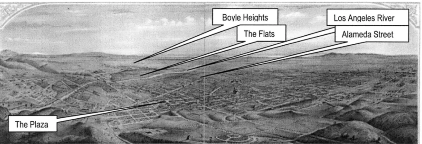
27 Detail, Stevenson Map, Los Angeles, 1884
28 Detail, Surveyor's Map of Los Angeles, 1877
29 Photograph, showing view east across the Los Angeles River, 1887
30 Detail, Sanborn map, Los Angeles, 1888
31 Detail, Sanborn map showing the area that would become Utah Street in the Flats, 1888
32 Detail, Sanborn map showing the area that would become Utah Street in the Flats, 1894
33 Detail, Sanborn map showing Anderson and Utah Streets, Los Angeles, 1906 34 Photograph, South Utah Street shacks, Los Angeles, 1910
35 Photograph, Part of Dumping Ground, South Utah Street, Los Angeles, 1910
36 Photograph, Utah Street Court, 1909
37 Map detail, Swede Hollow, Donnelley Atlas, St. Paul, 1892
38 Swede Hollow photograph showing Hamm's Mansion, undated
39 Swede Hollow photograph, c. 1910
40 "Where Life Moves Lovely," Black Bottom, Nashville Banner photograph, 1905 41 "A Family Group," Black Bottom, Nashville Banner photograph, 1905
42 Flats and the Court, Black Bottom, Nashville Banner photograph, 1910 43 Illustration, Molokan family at home, Los Angeles Times, 1907
45 "King of the River Bottom," Los Angeles Times illustration, 1901 46 "Old World Rites Mark Burial," Los Angeles Times photograph, 1932
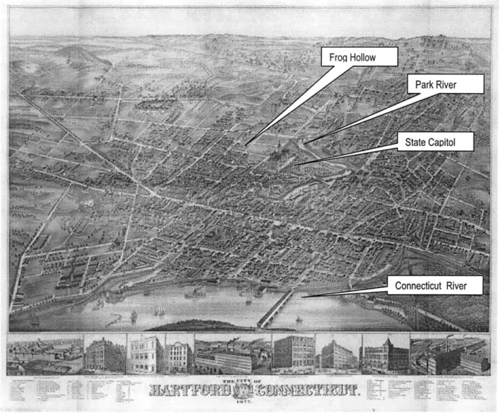
47 "A Street in the Flats of Los Angeles," photograph, 1932 48 Frog Hollow, Hartford, aerial photograph, 1900
49 Advertisement, The Johns-Pratt Company, Hartford City Directory, 1903
50 Sanborn map, Frog Hollow, 1921
51 Aerial photograph, Nashville Flood, 1926
52 General View, photograph, Columbus Flood, 1913
53 Broad and May, photograph, Columbus Flood, 1913 54 Rescue Boats, photograph, Columbus Flood, 1913
55 Track Damage, photograph, Columbus Flood, 1913
56 Flood Victim, photograph, Columbus Flood, 1913
57 Corner of Rich and Dakota, photograph, Columbus Flood, 1913
58 Front page editorial cartoon, Nashville Banner, 1905
59 "Map Showing Much Discussed Plan to Change Course of Scioto River," 1913
60 Front page, Columbus Evening Dispatch, September 13, 1913
61 Flood depths, Columbus Flood, Map from Alvord and Burdick report, 1913
62 Columbus Zoning Map, detail, undated
63 Details, Zoning Classifications, Columbus Zoning Map, undated 64 Hartford Zoning Map, detail, 1945
65 Los Angeles Zoning Map, detail, 1925
66 Detail, Baist's Real Estate Atlas, Los Angeles, 1921
67 Nashville Zoning Map, detail, 1933
68 "Buildings to Be Moved," Newspaper advertisement, Los Angeles Times, 1942
69 Photograph by Julius Shulman, Aliso Village, 1942
70 Flats tattoo, Los Angeles
71 "Swede Hollow Goes Up in Smoke as Shacks Burn," St. Paul Dispatch, 1956
72 Aerial photo, Foggy Bottom, Washington D.C., 1931
73 Land Use Changes over time in Black Bottom, Nashville, 1888-1957
Tables
1 A Simple Classification of Topography, Wealth, and Place Names
2 A Partial List of Bottoms, Hollows, and Flats as Historic Urban Place Names in the United States 3 Selected Cities from Arlinghaus and Nystuen's Classification of Terrain Peer Groups
4 First City Plans and Comprehensive Zoning Ordinances in Six Cities
5 Population Change in Six Cities, 1870-1930
ACKNOWLEDGMENTS
I would like to thank Professor Larry Vale, my advisor. He has been a great mentor over the span of five years: meeting with me on a regular basis, guiding my learning, suggesting new ideas, keeping me
laughing with his crazy puns, and answering my many questions on matters from ranging from protocol to publishing, conferences to contracts. I am grateful to have had a stellar committee, which in addition to my advisor, included Professors Anne Whiston Spirn, Sam Bass Warner, and Max Page. Anne Spirn
introduced me to so many new ideas, including her own work on buried floodplains in Roxbury and West Philadelphia- a major inspiration for this project. She also encouraged me to pursue my own ideas, sustained and supported my love of photography, and provided five years of patient and wise mentorship. Sam Bass Warner kept me on my toes, challenged me, and pushed me to become a better writer and historian. Max Page listened to my ideas as they were taking shape and helped me better understand how to be a thoughtful, confident, and generous scholar. I am very thankful to have received such wonderful support and guidance from the four of them.
Research for this project took me to public libraries, historical archives, colleges and universities, and low-lying urban neighborhoods around the United States. I am grateful for the assistance of many talented, patient, and helpful librarians and archivists, as well as professors, students, advocates, and planners. Special thanks go to Nick Taggart and Julie Callahan at the Columbus Metropolitan Library who provided assistance in locating maps, vertical files of newspaper clippings, city records, the 1908 Plan of Columbus, and numerous other documents and sources. Glen Creason at Los Angeles Public Library was
tremendously helpful in directing me to an incredible variety of detailed and useful maps. Michael Holland at Los Angeles City Archives seemed to be able to efficiently locate and immediately place before me almost any kind of record, from maps to legal records to pertinent secondary sources. In May 2010, it was a great pleasure to return to the American Swedish Institute in Minneapolis, Minnesota, and I'm very grateful to President and Chief Executive Officer Bruce Karstadt, Director of Programs and Exhibits Nina Clark, and archivist Virginia Taylor for their assistance. Debbie Miller of the Minnesota Historical Society Library and Brenda Miller at the Hartford History Center, Hartford Public Library both wrote very detailed answers to my research questions via email so that I could make the best use of my limited research time in those two cities. In Cambridge, Peter Cohn at MIT's Rotch Library was endlessly helpful. I still remember our first conversation about the project, discussing Washington D.C.'s Foggy Bottom neighborhood and my early ideas about low-lying places in cities.
Mary Rickel Pelletier of the Park River Watershed Revitalization Initiative, David Kelly at the Library of Congress, David Grinnell at the Heinz History Center in Pittsburgh, Doug Boyd at University of Kentucky Libraries, Stephen Greenberg at the National Library of Medicine at the National Institutes of Health, Laura Janssen at Historic Resources Group in Los Angeles, Phyllis Kendig and Mark Kile at the St. Paul Library, Jim Hannon at Nashville Public Library, and many other kind people also provided valuable assistance.
I would also like to thank the staff at the Franklinton Branch, Columbus Public Library; Ohio Historical Center archives, Columbus, Ohio; the state offices of historic preservation in Columbus, Ohio and Hartford, Connecticut; Special Collections Department, Nashville Public Library; Special Collections, Hartford Public Library; Metropolitan Archives of Nashville and Davidson County; Tennessee State Library and Archives; St. Paul Public Library; and the Minnesota History Center. Planners and city officials in a variety of departments in different parts of Columbus helped me track down the city's oldest extant zoning maps-special thanks to Vince Papsidero for sitting down with me for an impromptu discussion and Richard Makley at Building Services for taking the time to assist me with my unusual request. Also in Columbus, Professor Jennifer Cowley and Chris Hermann at MSI Design helped me obtain a copy of From the
Bottoms Up, a studio project report prepared by students at Ohio State University. I was fortunate to have
financial support from the Graham Foundation, the American Society for Environmental History, and MIT's Department of Urban Studies and Planning (Emerson travel fund) make several research trips to conduct field work and research materials only available in those places possible.
In the process of initial research and site selection, many others provided advice and recommendations. I had great conversations with Professors Joel Tarr at Carnegie Mellon University in Pittsburgh, Steven Conn in Ohio; Carla Yanni of Rutgers University, on a bus tour at the National Trust for Historic Preservation conference, in Tulsa, Oklahoma, of all places; David Lanegran at Macalester College; and Jim Wescoat and Rosalind Williams at MIT. Special thanks to Leo Marx for attending my dissertation colloquium, and provoking me to think more deeply about my topic.
The "Writing Cities" workshop in June 2009 was a welcoming atmosphere for presenting my work for the first time, and for receiving substantive feedback-it was also a great trip and my first visit to London. Thanks to all those involved, especially Professors Richard Sennett, Fran Tonkiss, and Gerald Frug, as well as all the student participants from LSE, MIT, and Harvard University. The Society for American City and Regional Planning History conference in October 2009 provided another supportive setting for me to test out my idea, and I'm very grateful for written comments provided by respondent Prof. Andrew Kahrl and Prof. Edward Muller for moderating the session. Thanks to Prof. Carl Abbott for the suggestion to check out Goose Hollow in Portland. Closer to home, the Massachusetts Historical Society has been a fantastic discovery. I have greatly enjoyed meeting people and participating in the discussions of the
Environmental History Seminar sponsored by MHS, including Karl Haglund, Professor William Meyer, and Conrad Wright, Editor and Director of Research. I met Megan Nelson there, a new friend and a wonderful colleague. Megan read drafts and abstracts, and always had insightful comments and helpful critiques. In March 2010, simply listening in on a workshop discussion at the American Society for Environmental History conference in Portland, Oregon, moderated by Prof. Matthew Klingle, proved very useful as well. I'm glad to have had the chance to meet so many interesting planning historians and urban environmental historians over the past two years!
Thanks also to my friends from Carleton and UCLA who entered academia several years ahead of me, and were willing to listen and provide advice as I went through the dissertation process. Prof. Jon Miller,
Queens University, read an early proposal draft. Prof. Miriam Petty, Rutgers, discussed African American literary and cultural references to "the bottoms" with me. Prof. Renia Ehrenfeucht, University of New Orleans, helped me sort through ideas and listened to me talk about this project at conferences and get-togethers in at least three different states.
During my travels, my friends John and Julia Hesse-Moline hosted me in their house in St. Paul, visited Swede Hollow with me, and generally showed me a wonderful time. In Los Angeles, Frank Parrello, Alexis
Moreno, Carolyn Cole, and John and Kathy Umbanhowar gave me encouragement, support, and the comfort of being with friends. Jeff Caltabiano probably exchanged more emails with me about this project than anyone except my advisor, and most of them had to do with blues music references to low-down places, floods, and, of course, the bottoms.
My sister Catherine Moga Bryant hosted me on my travels, too, talked to me over the years about the West Bottoms in Kansas City, and shared her own research ideas with me. Her geography thesis on flooding, community, and sense of place in a low-lying, rural, North Carolina town was frequently on my mind during this project, as I wondered about how residents felt about the places they lived in years past. My brother
Erik Moga had me laughing, suggesting arcane terms and phrases for inclusion in the text such as "the apoplexy of the urban condition." He also provided for the last minute conversion of graphic files into a format I could use. My Mom and Dad provided incredible amounts of support and encouragement over five
years at MIT, helping me with expenses, logistics, brainstorming, and in so many other ways. I am so thankful to have such fantastic parents. My wife Leigh has been, as always, steady, witty, loving, thoughtful, and supportive. She's been by my side during this entire time, writing her own dissertation in urban and regional planning-in our two-dissertation household! I'm so happy to be her partner, amazed by our journey together so far, and excited about the new adventures ahead of us.
PREFACE
New Orleans was one of many inspirations for this research. In Fall 2005, as I started the Ph.D. program in the urban studies and planning at MIT, I watched news of Hurricane Katrina, the flood that followed, its aftermath, and the beginnings of rebuilding. I had visited New Orleans several times before, read about its history, and wrote papers about it as an urban planning student. I felt great affection for the place and its people and as the news got more and more disturbing as the weeks went on that autumn, the
government's failed responses infuriated me. I started thinking a lot about the connections between low-lying places, race, poverty, flood risk, and urban development.
At the same time, I was in enrolled in Anne Spirn's seminar class, Urban Nature and Human Design. As I read her work on buried floodplains in Roxbury and West Philadelphia, I was suddenly struck by the sense that natural processes, poverty, and urban development patterns were interconnected in ways that few people seemed able to comprehend, or perhaps were willing to acknowledge. I remembered work I had done as a community outreach worker for five years in a low-income community in Minnesota-a creek ran
right through the middle of the apartment complex, basement apartments frequently flooded, and the site was hemmed in by a highway on one side and an airport on the other. I began thinking of it as low-lying land for the first time.
I thought about a place in Kansas City, where my sister had once lived, called the "West Bottoms." I thought back to my experiences on the Board of Trustees of the American Swedish Institute and a new permanent exhibit called "Swedish Life in the Twin Cities"-featuring an area of houses built in a ravine
where poor immigrants lived. It was called Swede Hollow. And I began making connections with many other places I had visited, researched, worked in, or read about, too-the low-lying neighborhoods next to the Los Angeles River; Foggy Bottom in Washington D.C., a strange name that had intrigued and puzzled me since I was a kid growing up in the area; and, Frogtown in St. Paul, another unusual name of the same type.
All these ideas swirled together at first, and I was unsure what to make of them. In Spring 2006, when it came time to write a brief description of what topic I had in mind for my dissertation, I wrote that I would conduct "an investigation of the historic development of one or more low-lying poor neighborhoods in American cities" and "explore the interconnections between socio-economic status, race, terrain, and planning." The title, I thought, would be "The Bottoms: Lowlands, Water, Disease, Race, Poverty, and Planning." As it turned out, the title would change, and there were many twists and turns along the way before I presented the topic in my dissertation proposal defense in December 2008, but that's where it started-an unusual combination of current events, a sense of injustice, reflections on past experience, and the excitement and sense of possibility that one gets when encountering new ideas for the first time.
The names provided the entry to the topic, and, as reflected in the final product, they continue to fascinate me. Reading Irving Allen Lewis's The City in Slang provided a key insight and the inspiration for the title-bottoms, hollows, and flats were colloquial names for stigmatized, low-lying places, words that combined social and physiographic description. Along the way,, the project continued to turn up surprises, new examples of the phenomenon, and a glint of recognition from many people I talked to-"Oh, I know a place like that," many said to me. In a literal sense, the project also took me to new places, including a four-week road trip through Scranton, Pittsburgh, Youngstown, Columbus, Cincinnati, Louisville, Lexington, Nashville, Atlanta, Columbia, Raleigh-Durham, and Richmond. Two places I visited on that trip would become key
components of the dissertation: Columbus and Nashville. It is my hope that this research encourages others to investigate this phenomenon and to cross disciplinary boundaries between water and poverty research, community development and landscape studies, geography and sociology.
INTRODUCTION
~~~~~~ ~~ Chapter 1
~~~~~~~-Lowlands and Highlands
In the colloquial language of American city form, "the bottoms" once meant both alluvial land and the place where poor people lived. Low-lying, poorly drained, and flood-prone, these city districts were often
immediately adjacent to hilltop neighborhoods with names like Quality Hill or The Heights, and separated by a tall bluff or steep incline. While real estate developers employed highland names as a common marketing device for middle and upper class suburban subdivisions, journalists, reformers, and neighbors used lowland names like bottom, hollow, and flat as slang terms for slums. In the nineteenth and early twentieth century, urban lowland residential districts became ubiquitous: they served as containment areas for many desperately poor people seeking opportunity in the city, finding housing nowhere available but in the topographical low zones.
Speculators, boosters, builders, and engineers transformed low-lying wet places into urban districts with earthen levees, concrete channels, brick-lined culverts, iron rails, stone foundations, and wooden houses. They made lowlands into poor neighborhoods to facilitate industrial development and social segregation. Landlords, property owners, and city leaders facilitated these settlement patterns. Ethnic, racial, and religious prejudice combined with municipal neglect to force the poor into "the bottoms." Some poor people squatted, building their own simple dwellings on available undeveloped lands, while others rented small houses or rooms. Some lowland residents owned their own dwellings, paying rent on the land they
occupied, others paid relatively high rents for a poorly maintained, shared room in a dilapidated building. Poor people lived in the lowlands, and they were regarded as strangers by the larger society: foreigners speaking unfamiliar languages with unusual customs, foods, clothing, and beliefs; former slaves and free blacks seeking opportunity in the city; poor country whites fleeing rural poverty.
Squatters, speculators, informal laborers, house builders, job seekers, railroad company men, and factory owners developed lowland areas into residential zones during the period of rapid industrial growth of the nineteenth century city. They built in ravines, on mud flats, under bridges, and along riverbanks, on poorly drained or flood prone land. Over time, below the bluff, across the river, or on the other side of the tracks
became a place for people denied access to more affluent parts of the city, forced down by a combination of lack of housing, racial and ethnic prejudice, and municipal neglect. The "strangers," urban newcomers arriving from the countryside or from abroad, settled downstream from mills, slaughterhouses, and
tanneries, and alongside railroad tracks at the river's edge. They sought out what housing opportunity they could find in little houses on steep hillsides, cottages perched on rocky terrain, shacks deep in a ravine, or other types of shelter on available lands. Factories, depots, and warehouses crowded up against urban rivers and streams, which provided water as a source for manufacturing processes and as a conduit for disposing of waste products. Low-lying slums became a defining element in the new urban landscape of the railroad-industrial city, a vertical stratification of city life.
From the 1870s onward, bottoms, hollows, and flats became a fixture of city life. The new districts often had platted streets, factories with jobs, and housing for workers, overlaying a geometric pattern of human development on top of a natural area defined by the curving lines of watercourses, hills, or bluffs. The nineteenth-century urban landscape that came to be defined by "factory, railroad, and slum" was dramatically evident in the lowlands, where factories, warehouses, and poor-quality housing were
constructed next to the tracks on the low-lying flat ground.' Some exceptions, such as difficult to reach high places, could be poor or working class neighborhoods. These types of places attracted unique reputations as notable counter-examples or inversions of the usual trend (often with unusual names like Poverty Hill), but the association between low places and "slums" was the dominant one. Forged by industrial-residential development patterns, lowland slums persisted well into the twentieth century.
Reformers urged city officials to "clean up" the slums, but property owners often had a vested interest in maintaining the status quo, at least until a more profitable land use came along. Over time, reformers, planners, and concerned citizen groups successfully eliminated some of the lowland "slums," taking
advantage of new rules and regulations like zoning. In an era of limited municipal power and professed faith in private solutions and laissez faire capitalism, elected officials were reluctant to interfere with property rights. But an even greater barrier to removal was the fear of middle and upper class homeowners that lowland residents might invade their neighborhoods if displaced. Devastating urban floods in the 1910s and
1920s brought new attention to the lowlands, just as planners tended to designate them as apartment districts or industrial areas on newly instituted zoning maps. Slum clearance, public housing,
redevelopment, flood control, and highway construction programs of the New Deal and urban renewal eras targeted lowlands, physically transforming them, dispersing populations. Immigration restrictions and mass suburbanization further reworked the urban landscape. A century later, their histories have been forgotten or erased. The history of these places brings into sharper focus the connections between physical planning, social inequality, and urban space that is particularly applicable to practicing planners in an era of renewed interest in the environment of cities.
These broad patterns of urban lowland development and the practice of labeling urban districts as bottoms, hollows, and flats, reflect the complexity of social-physical-natural interactions of place and the historical
significance of topography in shaping patterns of social segregation and urban poverty. As these neighborhoods became a fixture of the new urban landscape, city dwellers adopted new ways of talking about the emerging "ethnic" lowland slums by using pejorative labels and inventing new place names.
...vertical metaphors place the rich on high ground or the poor on low, and this is historical fact in many cities. Horizontal or lateral figures of speech usually place the rich and poor neighborhoods either on this or that side of, in front or in back of, or near to or far from features of the urban environment that symbolize class divisions. These features are usually a dirty, noisy, or malodorous industrial activity, such as railroad tracks, stockyards, or the gas works... Vertical classifications of rich and poor areas reflect the historical tendency for the rich and powerful to build on high ground, leaving, if not forcing, the poor to live on low ground, such as in bottoms, hollows, and flats, often on the other side of the tracks.2
Bottoms, hollows, or flats were commonly used words for places where poor people lived in the city.3
Negative associations with low or down are a common part of American speech, such as "low status." Linguist George Lakoff and philosopher Mark Johnson argue that this metaphor is one in which
"spatialization is so essential a part of a concept that is difficult for us to imagine any alternative metaphor that might structure the concept."4 They provide several examples to illustrate the general rule that "HIGH STATUS IS UP; LOW STATUS IS DOWN": "He has a lofty position. She'll rise to the top. He's at the peak
of his career. He's climbing the ladder. He has little upward mobility. He's at the bottom of the social hierarchy. She fell in status."5
These names constituted a new language reflecting a new socio-spatial understanding of the industrial city, an uneven physical landscape with slums in low places. They expressed both topography and poverty in one phrase, fusing together pejorative cultural associations and ascribing marginality. City dwellers used landscape names to represent the people who lived there. Urban lowlands were clearly bounded and demarcated, and they were isolated. As urban districts they became associated with the characteristics of the people that lived there, with city dwellers labeling them with ethnic and racial descriptors, animal names, or adjectives associated with poor air quality or other environmental conditions. Black Bottom
(Nashville, Philadelphia, Detroit, and elsewhere), Russian Bottoms (Lincoln, Nebraska), Swede Hollow (St. Paul), Bohemian Flats (Minneapolis), Smoky Hollow (Youngstown, Ohio), Skunk Hollow (Pittsburgh), Frog Hollow (Hartford), Foggy Bottom (Washington D.C.), West Bottoms (Kansas City), Shockoe Bottom (Richmond), and Tortilla Flats (Ventura, California and elsewhere) are a few of the more prominent English language examples. Many districts also acquired names in the languages spoken by residents and
immigrants such as Svenska Dalen (Swedish for Swede Hollow, St. Paul), El Hoyo (Spanish for "The Hole"-East Los Angeles), or Basso La Vallone (Italian for "Down in the Hollow," Pittsburgh). Other districts were simply known as The Bottoms (Columbus, Ohio) or The Flats (Los Angeles). City dwellers mixed and mingled descriptors of land and water features, some of them older terms and place references, with ethnic labels and sobriquets to describe the lower section of the American city. The resulting place names, while often offensive and derogatory, spoke powerfully to the emergence of the new residential-industrial zones inhabited by marginalized strangers.
In contrast, the highlands offered a residential environment that was less noisy, odiferous, and dangerous. Describing the Twin Cities of Minneapolis and St. Paul, architectural historian Larry Millet explains how topography became associated with class, representing a new social geography of the city.
The hierarchy of altitude was especially strong in the Twin Cities in the late nineteenth century. While the rich resided in their mansions on Summit Hill in St. Paul and Lowry Hill in Minneapolis, the poorest Twin Citians were tucked away-out of sight and mind-in deep holes like Swede Hollow or on the floodplains below the river bluffs. Isolated from the city by barriers of language, culture, and geography, these enclaves were often identified with a particular ethnic group, although most were actually quite diverse in their makeup.6
As Millet explains, often the reasons for settlement had more to do with access to work and affordability in the industrial city than any "natural" connection between the poor and low places. Along the Mississippi River, he writes, "land was so cheap that even the poorest families could build homes of their own."7
Figures 1 and 2: Advertisement for Boyle Heights, a subdivision of Los Angeles, as it appeared in the Los Angeles Herald, 1906; Advertisement for Congress Heights, a streetcar suburb of Washington D.C., from the Washington Times, 1902. Note the reference to high land and health, a common theme found in these advertisements. In Washington D.C.'s Congress Heights, the promoter informs us, "health is wealth."
Writers like Sinclair Lewis observed this phenomenon, generalized it, and made it a part of American literature and culture. Geographer William Meyer described Lewis's setting for the novel Babbitt.
The Midwestern city of Zenith, from what we know of it, had a clear residential pattern during the 1920s: income and status rose with altitude. The lower classes dwelt in the lowlands near the Chaloosa River. The development of Floral Heights, commanding a view of the city from a hillside, catered to the middle class. The city's wealthiest families lived on Ridge Crest Road, its name denoting a topographic summit and suggesting a social one. The most attractive new suburbs were springing up in an outlying area of wooded hills. Even advertisements for the cemetery emphasized its elevation and view. Zenith existed only in the novels of Sinclair Lewis... But if it was a creation of fiction, it was not one of fantasy.8
Lewis's readers were familiar with the ups and downs of city terrain, and they recognized the social meaning of topographical and spatial difference. In the smaller scale of many nineteenth and early
twentieth century cities, the spatial segregation of the poor was visibly interconnected with the features of the natural landscape. Lowlands became associated with industrial pollution, noise, crime, disease, and flood danger, "the heights," "highlands," and hilltops became desirable residential subdivisions.
Of course, the pattern of low-income residence in low-lying areas was never absolute. Indeed, while many low-income people ended up in the bottoms, it was not the only place for the poor. Likewise, some low-lying places have historically been associated with high-income residence, such as coastal areas and lakefronts. Comparing income-related residential characteristics by elevation or altitude yields a matrix with four cells, as seen in Table 1.
Table 1: A Simple Classification of Topography, Wealth, and Place Names
High elevation Low elevation
The Heights
Rich Highlands Waterfront Property
Hilltop Quality Hill
Bottoms
Poor Poverty Hill Hollows
In studies of Worcester and Boston, Massachusetts, Meyer found several historical examples of high elevation, low status residential areas.9 Sociologist Irving Allen Lewis explains that "[t]he metaphor, too, is
sometimes turned on its head and denotes poor areas as if they were on a hill-and sometimes they actually were. High elevations in certain geographic surroundings can be undesirable places to live for a variety of reasons, such as difficult access, and locally symbolize low status."10 He adds that in New York,
Vinegar Hill and Dutch Hill were considered undesirable, but "[t]he hill more usually was a high-status place to live, as on Washington Heights."11
It should also be noted that in many cities across the country, cities cut down hills to fill in marshy land, improve traffic flow, and eliminate steep slopes.12 For example, Boston's hill cutting and land making began
in the eighteenth century. "In 1799, the Mount Vernon Proprietors bought John Singleton Copley's property on the Trimountain, at the time mainly upland pasture; four years later, [they] had fifty to sixty feet sliced off the top of Mount Vernon, carted down the hillside in a gravity railroad, and dumped in the water at the base."13 Perhaps the most famous example of making new land is Boston's Back Bay. Begun in 1858, and lasting almost forty years, developers brought gravel by railroad nine miles from Needham to fill the marshes and construct a new exclusive residential district. Filling in areas as large as the Back Bay and cutting down hills were expensive propositions, ones beyond the scope of resources of smaller cities, but the motivation and intent to remake the landscape, especially for residential real estate development, was commonplace. As we shall see, developers and engineers modified the urban landscape of city after city by constructing culverts, drains, flumes, canals, embankments, levees, and bridges.
At the same time, the low-lying American slum was ubiquitous. Indeed, dramatic achievements in civil engineering such as new bridge spans literally bypassed the lowlands, creating new vantage points for looking down on the poor people living below. Like other slums, the lowlands were separated from other
parts of the city, a change from earlier building practices when the poor tended to live in alleys or smaller dwellings at the interior of a city block.'4 Figure 3 shows how physiographic, socio-economic, and built environment characteristics defined the urban lowland slum, as distinguished from other lowland and poor landscapes of the American city.
Figure 3: Urban bottoms, hollows, and flats as the intersection of three characteristics: poverty, urban residential land use, and low topography. Note that non-urban lowlands, non-poor urban lowlands, and slums on other types of terrain are not considered part of the phenomenon to be investigated.
For some city residents, the slum became a place to visit for charity work, entertainment, or exploration yielding the term "slumming."15 "By the 1880s the middle classes, through their agents of social control, had
seen to it that most low forms of prostitution, gambling, and illegal drinking had been driven into the slums. The well-to-do had to go slumming to find low forms of vice and entertainment."16
As landscapes, these districts provoked debate about the proper relationship between built areas and open spaces in the city. As lived environments, they aroused racist, anti-immigrant fears about disease, housing conditions, and moral behavior. As planning problems, they attracted the attention of sanitarians, housing reformers, and landscape architects-the same professionals that would establish urban planning as a discipline in its own right. As urban places, they were mythologized, despised, and constantly subjected to calls for resident removal and dispersion.
Urban lowlands like "the Bottoms" have historically suited various human needs: economic, political, and social. Real estate speculators, park advocates, and civic leaders, among many others, have viewed the low-lying landscape as a template upon which to create something useful, profitable, or beneficial to the city. In this way, lowlands are no different from other places in the city. What is unique about urban lowlands, however, is the set of constraints and opportunities they represented to city builders and urban reformers in the nineteenth and twentieth centuries. The physical features of the land became attributes of "site" that defined their real estate value as well as potential uses. The dictates of each particular
macroeconomic phase or technological era, whether it be the fundamental necessity of river-based transportation and commerce, the economic urgency and pressures related to developing new railroad connections, or the rapid growth in the urban population and the need for housing spurred by industrial development, influenced how social elites, city officials, and powerful industrial and corporate interests saw the lowlands.
Case Selection and Methods
This dissertation analyzes six case study sites: the Bottoms, Columbus, Ohio; Frog Hollow, Hartford, Connecticut; The Flats, Los Angeles, California; Black Bottom, Nashville, Tennessee; Swede Hollow, St. Paul, Minnesota; and, Foggy Bottom, Washington, D.C. I chose the number of cases (six) in order to have a large enough sample to examine a variety of conditions, but not so many as to make in-depth, qualitative research infeasible. Individual cases were selected based on five characteristics: urban setting (not rural or small town); low topography (observable physiographic characteristics); neighborhood scale (one of several neighborhoods with a city); named bottom, hollow, or flat (not necessarily in current use); and history of poverty and/or reputation as a slum district (as documented in secondary sources and/or local histories).
The set of cases was chosen to include examples from different regions of the United States as well as to include both flat cities and hills cities (see Table 3). Cases that were too small in scale (a small cluster of homes, for example) or too large in scale (an entire city or region) were rejected. In addition, a month-long field investigation trip to sites in the Eastern United States and preliminary research were conducted to determine the suitability of the cases for in-depth research. Nashville's Black Bottom was chosen from the compiled list of multiple Black Bottom neighborhoods around the United States due to its age and urban setting: research indicated that it was one of the oldest and largest neighborhoods with this name, and its presence was perhaps one reason why the name became widespread historically.
Table 2: A Partial List of Bottoms, Hollows, and Flats as Historic Urban Place Names in the United States
# Place Name city State # Place Name City State
1 American Bottoms N/A Illinois 31 Foggy Bottom Washington D.C.
(region)
2 Anacostia Flats Washington D.C. 32 Frog Hollow Hartford Connecticut
3 Black Bottom Columbia South 33 Fulton Bottom Richmond Virginia
Carolina
4 Black Bottom Detroit Michigan 34 Goose Hollow Portland Oregon
5 Black Bottom Jacksonville Florida 35 Happy Hollow Omaha Nebraska
6 Black Bottom Lakeland Florida 36 The Hollow Bridgeport Connecticut
7 Black Bottom Nashville Tennessee 37 Mosquito Flats Iowa City Iowa
8 Black Bottom Philadelphia Pennsylvania 38 North Bottoms Lincoln Nebraska 9 Bohemian Flats Minneapolis Minnesota 39 Panther Hollow Pittsburgh Pennsylvania
10 The Bottom Alexandria Virginia 40 Rock Island Fort Worth Texas
10 irgniaBottomThe ott mAl xanria
11 The Bottom Charlottesville Virginia 41 Russian Bottoms Lincoln Nebraska
or South Bottoms
12 The Bottom Cincinnati Ohio 42 Scranton Flats Scranton Pennsylvania
(also First Bottom, Second Bottom)
13 The Bottoms Baton Rouge Louisiana 43 Sheridan Hollow Albany New York 14 The Bottoms Battle Creek Michigan 44 Shockoe Bottom Richmond Virginia 15 The Bottoms Columbus Ohio 45 Skunk Hollow Pittsburgh Pennsylvania 16 The Bottoms Durham North 46 Slocum Hollow Scranton Pennsylvania
Carolina
17 Buttermilk Bottom Atlanta Georgia 47 Smoky Hollow Youngstown Ohio 18 Chicago Bottoms Lexington Kentucky 48 Southside Flats Pittsburgh Pennsylvania 19 Cow Hollow San California 49 St. Paul's Bottom Shreveport Louisiana
Francisco
20 Crawfish Bottom or Frankfort Kentucky 50 Swede Hollow St. Paul Minnesota
"Craw"
21 Davis Bottom Lexington Kentucky 51 Tanyard Flats Atlanta Georgia
22 East Bottoms Kansas City Missouri 52 Tortilla Flats Ventura California 23 Eastman Flats Minneapolis Minnesota 53 Trimble Bottom Nashville Tennessee
24 Felony Flats Portland Oregon 54 Village Bottoms Oakland California
25 Felony Flats Spokane Washington 55 West Bottoms Kansas City Missouri
26 The Flats Cleveland Ohio
27 The Flats Los Angeles California
28 The Flats Rochester New York
29 The Flats Wilmington Delaware
o 4 North ntanka Dakota South Dakota Wyoming Nebras Colorado .,_ Oklah 0 Arizona New 0 Mexico Texas 0 0 rd 0
Figures 4 and 5: Distribution of identified urban neighborhoods named bottoms, hollows, and flats (top map) compared to location of the six case study sites: Los Angeles, St. Paul, Nashville, Columbus, Washington D.C., and Hartford (bottom map).
Research on the six case study sites included field observations, site photography, and interviews. Historical sources consulted included primary sources in archives and libraries, local histories, and other secondary sources. Archival research included visits to the Columbus Metropolitan Library, Ohio History Center, City of Columbus, Hartford Public Library, Los Angeles Public Library, Los Angeles Tax Assessor Map Archive, Los Angeles City Archives, Nashville Public Library, Metropolitan Archives (Nashville/ Davidson County), Tennessee State Library and Archives, St. Paul Public Library, American Swedish Institute, Minnesota Historical Society, and the Library of Congress. Newspaper research involved
internet-based and microfilm searches of the Columbus Dispatch, Ohio State Journal, Hartford Courant, Los
Angeles Times, Los Angeles Herald, Nashville American, Nashville Banner, The Tennessean, St. Paul Daily Globe, St. Paul Pioneer Press, Washington Post, Washington Times, New York Times, Atlanta Constitution, and other newspapers. Maps consulted included Sanborn fire insurance maps, real estate
maps, topographical maps, tax assessor maps, zoning maps, plat maps, street maps, parcel maps, and GIS maps. Additional sources included correspondence, student reports, dissertations, city plans, legal records, and city directories.
Hills Cities and Flat Cities
Looking at the city as a unit, as an area of terrain with varying altitudes and physiographic features, it is commonly said that there are "hills cities" and "flat cities." San Francisco, Seattle, and Pittsburgh are regarded as three of the hilliest cities in the United States. In these places, hills and valleys are unavoidable. Topography is omnipresent, a part of the place. Steep slopes traversed by cable cars or funicular railways, staircases or even ladders, became part of the city fabric and the city identity. In some cities, topography has been considered like a constructed feature, a stage for city life, a backdrop, or a
setting. In Cincinnati, local historians have referred to the city's site as a "natural amphitheater" with hills on three sides and an opening to the river.17 Topography and city interconnect making each city unique. In "flat cities" like Chicago or Columbus, Ohio, elevation is typically disregarded as a factor in city form.
Nevertheless, small differences in topography may influence where water flows and what areas flood. All cities are three-dimensional; some cities simply have a greater range of altitudinal variation.
Table 3: Selected Cities from Arlinghaus and Nystuen's Classification of Terrain Peer Groups18
Flat Intermediate Steep
New York Philadelphia Los Angeles
Chicago Cleveland Washington D.C.
Detroit Baltimore Boston
Louisville Atlanta Seattle
Houston Minneapolis/ St. Paul San Francisco
Miami St. Louis Pittsburgh
Garden Grove CA Milwaukee Oakland
New Orleans Denver Cincinnati
Norfolk VA Portland OR San Diego
Phoenix San Antonio Kansas City
Buffalo San Jose Omaha
Columbus OH Hartford Duluth
Rochester NY Nashville Yonkers
Table 3 shows a typology classifying cities by altitudinal variation developed as part of a study of bus routes. The authors studied the effect of terrain on citywide bus systems, creating a measure of relative hilliness of cities in order to produce comparison or "peer" groups.
In this dissertation, case studies have been chosen to reflect a range of terrain conditions, including some cities characterized by little variation in altitude across the city and other cities with a high variation and steep slopes. According to Arlinghaus and Nystuen's classification, for instance, Columbus is a flat city; Hartford, Nashville, and St. Paul are intermediate cities; and, Los Angeles and Washington D.C. are cities
with steep terrain. It should be noted that Arlinghaus and Nystuen developed their measure in the 1980s, after significant cutting and filling occurred in many cities. It is also the case that some cities sorted into different categories here share significant terrain characteristics, such as Philadelphia and Washington
D.C.: both located on the piedmont-coastal plain fall line. The typology is employed here only as one
possible, simple measure of city terrain type.
Urban Nature
The combination of built form with natural features and ecological systems that results from human action expressed in cities may be called architecture, cityscape, urban nature, or landscape. The built
environment and social character of various districts of the city are interrelated with natural features and systems. The city is not simply built on the land, it is where land and water (and air) come together, creating riverfronts, harbors, dumping places, railroad districts, parks, and neighborhoods.
In The Granite Garden, Anne Whiston Spirn described the common failure to appreciate natural processes
in cities and warned of the dangers of neglecting nature's power.
Nature pervades the city, forging bonds between the city and the air, earth, water, and living organisms within and around it. In themselves, the forces of nature are neither benign nor hostile to humankind. Acknowledged and harnessed, they represent a powerful resource for shaping a beneficial urban habitat; ignored or subverted, they magnify problems that have plagued cities for centuries, such as floods and landslides, poisoned air and water. Unfortunately, cities have mostly neglected and rarely exploited the natural forces within them.19
The dangers posed by floods and other hazards have been a particular and long-lasting concern for city builders. The hardest hit areas are often the low-lying "natural-process lands" along the riverfront, the
bottoms and flats.20 Likewise, low areas alongside creeks and streams in ravines and gullies may be subject to destructive downhill flows. Urban lowlands are part of the city and part of nature.21
In cities across the United States, low-lying landscapes were transformed in the late-nineteenth and early-twentieth centuries with continuing implications for urban neighborhoods and human wellbeing in cities. Spirn documented these changes in one urban neighborhood over more than a century.
Take the example of the Dudley Street neighborhood in the Roxbury section of Boston... The neighborhood consists of four distinct physiographic units: the lower slopes of a broad plateau; a knoll; a flat lowland; and a valley that separates the two higher land forms. In the 18th and 19th centuries, the landscape of this neighborhood consisted of estates and farms; the valley bottom was the floodplain of a large stream. Between 1854 and 1906, the landscape changed
dramatically. The estates and agricultural fields were replaced, first by large, single-family homes, then by smaller, attached houses, commerce and industry. The stream in the central valley was visible on maps as late as 1884. By 1906, however, most of the floodplain had been filled and built upon, and the stream was buried underground in a large sewer. Between 1964 and 1986 this process was reversed, as the neighborhood became subject to disinvestment and abandonment. Although 30% of the land in the entire neighborhood is now vacant, 90% of the old floodplain is vacant, and only 20% of the knoll is vacant; almost all of those vacancies occurring on the lower slopes. This pattern is repeated in Boston's other inner-city neighborhoods... 22
In subsequent research, Spirn found a similar historical process at work in the Mill Creek neighborhood of Philadelphia, where she founded the West Philadelphia Landscape Project.
Spirn's analysis of the long process of landscape change over time in Dudley Street in Boston and Mill Creek in West Philadelphia powerfully demonstrates the significance of urban lowlands to cities. Beginning in the mid-1 980s, she documented how "valley bottoms" were systematically built over in the late
nineteenth and early twentieth centuries, often with poorly-constructed multi-family housing; how these houses and apartment buildings frequently subsided, flooded, or collapsed; how floodplain processes continue when creeks and streams are put underground in pipes; and how vacant land in these areas represents a potential resource for addressing environmental problems such as combined sewer overflows
and as inspiration for future planning and design, if natural processes are taken into consideration.23 She
coined the term "buried floodplain" to describe this phenomenon.24
As Spirn has shown, environmental, social equity, and physical planning issues are deeply intertwined within urban lowlands and cities. This thesis builds upon Spirn's path-breaking lowland work, extending it to describe the phenomenon in six other cities, examining historic and cultural aspects such as the language of lowlands, drawing connections, and offering an analytical history of the forces and interests that conspired to produce deliberately incomplete development in these areas.
In the historical processes of laying out cities, and especially in their subsequent building and rebuilding, topographical and natural features like bluffs and river bottoms, ravines and creeks, plateaus and hilltops became the setting and the backdrop, as well as the architect or designer's "site," for human building activities. The urban landscape is comprised of built as well as un-built, "natural," or "open space" features. The city presents a complex, ever-changing tableaux of spatial relationships over time. Urban lowlands are a unique part of the city fabric in that they are the location of waterways, as well as constructed urban systems of water supply, waste disposal, and drainage. Historically they have been simultaneously
centrally-located and socially marginal. Low-lying places once defined by small creeks, streams, brooks, or runs that flowed across the surface of the land, down towards the river or the harbor, were remade. Urban systems replaced natural ones to facilitate waste disposal and flood control objectives.
Low-lying topography is not a person-it does not have agency. People made these decisions in relation to factors as diverse as design trends, engineering technologies, building practices, available materials, economy, and cultural and social understandings. Ideas in architecture and town planning also played a role. Likewise, the social meanings of those built districts, zones, and neighborhoods were also diverse.
Nevertheless, the pattern that developed from the process of city growth and expansion in the nineteenth-century city: the lowlands became the domain of the poor.
Floodplains
Bottoms, hollows, and flats are often referred to as floodplains, a powerful term with its own history. The
Oxford English Dictionary and Merriam-Webster Dictionary date the first use of the term to 1873, but it was not until the 1930s that the phrase began to be widely used (and spelled as floodplain rather than flood plain) in the United States.25 Geographer Gilbert White pioneered research on floods and human responses
to them.26 In the simplest definition, the floodplain is an area of land that floods. Stated in terms of natural
processes, floodplains can be defined as "natural detention areas for storm water."27
White used the term "flood plain" as early as 1937, when he published "Notes on Flood Protection and Land-Use Planning" and served as the Secretary of the Water Resources Committee of the Natural Resources Committee under President Franklin D. Roosevelt.28 Assigned the task of reviewing flood control proposals, White became skeptical of the approaches being used.29 He wrote at the time: "Floods are natural phenomenon; flood damages are the products of human action. With few exceptions, major flood flows result from natural, hydrological events; and with few exceptions the damages... are the price of man's encroachment upon natural flood plains."30
According to White, a floodplain is not necessarily coterminous with the area where alluvium is deposited or the same as "a plain built up by stream deposition."31 In his "highly influential University of Chicago
dissertation," published in 1945 under the title Human Adjustment to Floods: A Geographical Approach to
the Flood Problem in the United States, White gave a detailed definition of the term.32
The term flood plain is used to mean that land outside of a stream channel described by the perimeter of the probable limiting flood. It is land which is not covered by the stream at low flow or average flow, but which has been flooded in the past or may be flooded in the future. It has no other essential feature; it may be broad or narrow, frequently flooded or rarely flooded. In this sense, every stream which floods also has a flood plain... This definition of flood plain differs from that commonly employed by geomorphologists, who use it to mean the alluvial floor of a valley...
Indeed, none of the common geological classifications of streams or valleys is of special
significance in a broad approach to the flood problem. From the standpoint of human adjustment to flood hazard, it makes little difference whether a segment of a stream valley is consequent of subsequent, mature or old, rejuvenated or drowned. The significant physical features are the width of the plain, its slope, its underlying materials, and its position in the stream system (emphasis in
original).33
White defined the differences between narrow flood plains ("an average width of less than 120 feet"), medium flood plains ("an average width of more than 120 feet and less than one-half mile"), and broad flood plains ("an average width of more than one-half mile").34 He noted that "120 feet...
is the average width of the necessary right of way for a single-tract railroad together with a two-lane highway, and it also coincides roughly with the minimum width of fields for effective cultivation in many parts of the United States" and "[o]ne-half mile is selected as a convenient limit diversion between medium and broad flood plains of urban occupancy adjacent to a highway and a railway, or for a square-shaped farm having an area of 160 acres."35
White's analysis is relevant to this investigation in two ways: first, it provides context for understanding the idea of "floodplains" in historical perspective as an analytical concept, and later as a land use planning tool, that researchers developed decades after major flood events in many American cities; second, it suggests the state of floodplain research at the time that many urban lowlands were cleared and redeveloped. In
1958, the University of Chicago published a second influential analysis of floodplains by White and several
colleagues titled Changes in Urban Occupance of Flood Plains in the United States.36 As the following case studies demonstrate, the occupants of many of these low-lying urban neighborhoods were historically the
poor and marginalized. By the 1950s, however, many cities were in the process of removing these residents and remaking the lowlands. Finally, White's analytical framework, combined with Spirn's "buried floodplain" concept, provides a way to assess smaller-scale, hybrid landscapes where nineteenth century systems of engineered drainage and sanitation interact within natural processes in urban neighborhoods.
The Lower Section and the Whole of the City
Models of urban form typically represent the American city as a flat plane with streets, blocks, and districts arrayed across a two-dimensional space. Rarely is the city depicted in three dimensions other than with contour lines on a topographical map. Yet, the city itself stands on an infinitely varied surface, one that reveals much about ecology and morphology, as well as building practices and historical patterns of urban real estate development. A city is tall and short, high and low, with constructed views, overlooks, and
vantage points. Underlying the built features of the city are hills, bluffs, mesas, outcroppings, and gradual or steep slopes, as well as low-lying land along creeks and streams, land upon river banks and bottomlands, and land down in valleys, dales, and ravines.
Planners, architects, and landscape architects often refer to the relative advantages or disadvantages of a particular building site, but in a broad sense the whole city is a three-dimensional site. Vincent Scully described architecture as a way to make meaning out of nature, a process that results in the city as a whole.
The shape of architecture is the shape of the earth as it is modified by the structures of mankind. Out of that relationship, human beings fashion an environment for themselves, a space to live in, suggested by their patterns of life and constructed around whatever symbols of reality seem important to them. Most of all, that environment and those structures invest the vast indifference of nature with meanings intelligible to, indeed imagined by, mankind, and they involve in the end all
those complex relationships of human buildings with each other that shape within nature a new manmade topography: the human city entire.37
Americans have made and remade lowlands into a "manmade topography." Urban lowlands are a
physically and socially constructed place-one imbued with cultural meaning reflecting the way we interact with one another and the way we build and understand cities as places to live.
Views and vistas reflect one key aspect of city form. Buildings sited on peaks, points, and hilltops become prominent landmarks. Lowland building sites, in contrast, often occupy prominent positions by virtue of their relationship to water, open spaces, or visibility along an open plain. The bend in a river or a slightly
elevated point amongst a flat plain may also be prominent sites. However, inside a basin or a hollow, or below the grade of the rest of the city, buildings, blocks, or indeed entire neighborhoods may be hidden, tucked away, less visible in the city framework. Bowls, depressions, holes, ravines, dales, and valleys may
become the hiding places of the city.
They often became known as slums, a concept that has been central to urban planners' definition of what is good and bad in the city, theories of the internal structure of cities, and notions of how to make a better city. The word has its English language roots in the early nineteenth century and, as Allen explains, has historic associations with lowlands.
Slum entered British English about 1825, although not American English until about 1870. The word is of
unknown origin and so it the subject of much speculation. Yet we can reasonably posit that slum originally meant a small, low, unclean, and possibly wet place of human resort and was later extended to an urban area of such buildings... the history and connotations of slum all indicate a negative idea (emphasis in original).38
By the 1937, when slum clearance became an explicit goal of federal policy, the word slum had an official
definition: "The term 'slum' means any area where dwellings predominate which by reason of dilapidation, overcrowding, faulty arrangement or design, lack of ventilation, light or sanitation facilities, or any
combination of these factors, are detrimental to safety, health, or morals."39 Low-lying slums have been
closely tied to conceptions of nature in the city, playing a key role in our understanding of healthy and unhealthy places, natural processes and urban systems, scenic and ugly places, and urban hazards.
Natural Areas and Concentric Zones
Urban theory has been strongly horizontal in its orientation, neglecting the vertical dimension of cities and differences in terrain. Models based on concentric circles, sectors, and multiple centers represent the three classic formulations of how cities grow and expand over time. The most well-known of these diagrams, indeed one of the most famous diagrams in social science, is Ernest Burgess's concentric city model. Associated with the so-called Chicago School of sociology, Burgess and colleagues Robert Park, Roderick McKenzie, and Louis Wirth developed the model based on their studies of Chicago in the 1920s. In "The Growth of the City," Burgess modeled "the typical processes of the expansion of the city" in "an ideal construction" showing the tendency of cities to "expand radially from [the] central business district."40 In the expansion of the city a process of distribution takes place which sifts and sorts and relocates individuals and groups by residence and occupation. The resulting differentiation of the
cosmopolitan American city into areas is typically all from one pattern, with only interesting minor modifications. Within the central business district or on an adjoining street is the 'main stem' of 'hobohemia,' the teeming Rialto of the homeless migratory man of the Middle West. In the zone of deterioration encircling the central business section are always to be found the so-called 'slums' and 'bad lands,' with their submerged regions of poverty, degradation, and disease, and their underworlds of crime and vice.4
Numerous studies by Chicago School theorists would echo the "sifting and sorting" notion, and the model came to be represented by a powerfully simple image: the concentric circle diagram.