Publisher’s version / Version de l'éditeur:
Vous avez des questions? Nous pouvons vous aider. Pour communiquer directement avec un auteur, consultez la première page de la revue dans laquelle son article a été publié afin de trouver ses coordonnées. Si vous n’arrivez pas à les repérer, communiquez avec nous à [email protected].
Questions? Contact the NRC Publications Archive team at
[email protected]. If you wish to email the authors directly, please see the first page of the publication for their contact information.
https://publications-cnrc.canada.ca/fra/droits
L’accès à ce site Web et l’utilisation de son contenu sont assujettis aux conditions présentées dans le site LISEZ CES CONDITIONS ATTENTIVEMENT AVANT D’UTILISER CE SITE WEB.
Internal Report (National Research Council of Canada. Division of Building Research), 1961-12-01
READ THESE TERMS AND CONDITIONS CAREFULLY BEFORE USING THIS WEBSITE.
https://nrc-publications.canada.ca/eng/copyright
NRC Publications Archive Record / Notice des Archives des publications du CNRC :
https://nrc-publications.canada.ca/eng/view/object/?id=b6665547-1b3c-4797-8a3c-e226f730b565 https://publications-cnrc.canada.ca/fra/voir/objet/?id=b6665547-1b3c-4797-8a3c-e226f730b565
NRC Publications Archive
Archives des publications du CNRC
For the publisher’s version, please access the DOI link below./ Pour consulter la version de l’éditeur, utilisez le lien DOI ci-dessous.
https://doi.org/10.4224/20338093
Access and use of this website and the material on it are subject to the Terms and Conditions set forth at
Avalanche hazard evaluation and prediction at Rogers Pass Schaerer, P.
NATIONAL RESEARCH COUNCIL CANADA
DIVISION OF BUILDING RESEARCH
THE AVALANCHE HAZARD EVALUATION AND PREDICTION AT ROGERS FASS P. S c h a e r e r This i s a j o i n t r e p o r t o f . t h e Department of P u b l i c Works and t h e N a t i o n a l Research Council I n t e r n a l Report No. 227 of t h e D i v i s i o n of B u i l d i n g Research Ottawa December 1961
The Trans-Canada Highway through G l a c i e r National Park, B r i t i s h Columbia, w a s designed and c o n s t r u c t e d by t h e Federal Department of Public Works, Because t h e highway would have t o c r o s s numerous avalanche p a t h s , t h e Department began, a s e a r l y a s 1953, preliminary observations on t h e snow cover, weather and avalanche c o n d i t i o n s t h a t would be encountered and i n t h e w i n t e r of 1955-1956, e s t a b l i s h e d a r e g u l a r observation program t o provide t h e information r e q u i r e d f o r t h e s p e c i f i c a t i o n of t h e avalanche defences.
I n 1956, t h e National Research Council, i n response t o a r e q u e s t from t h e Department of Public Works, s u p p l i e d some of t h e s p e c i a l instruments r e q u i r e d f o r t h e observations. About t h a t time, t h e Division of Building Research of t h e Council r e - c r u i t e d t o i t s s t a f f a c i v i l e n g i n e e r t r a i n e d i n Switzerland. i n road c o n s t r u c t i o n . The s e r v i c e s of t h i s e n g i n e e r , M r . Schaerer, were o f f e r e d t o t h e Department of Public Works. I n 1357 he was
seconded t o t h a t department and given t h e t a s k of recommending t o them t h e avalanche defence f o r the highway. Through M r .
Schaerer and valuable c o n t a c t s w i t h D r .
M.
R. de Quervain, D i r e c t o r o f t h e Swiss Federal I n s t i t u t e f o r Snow and Avalanche Research, t h e valuable experience of t h e Swiss was a p p l i e d t o t h e problem a t Glacier.!Phe development of t h e avalanche defence f o r t h e Trans-Canada Highway through t h e park a r e a , and t h e a s s o c i a t e d snow cover, weather and avalanche o b s e r v a t i o n s r e q u i r e d f o r t h e s p e c i f i c a t i o n of t h a t defence, was t h e f i r s t p r o j e c t of i t s kind t o be undertaken i n Canada. I t i s probable t h a t t h i s p r o j e c t w i l l serve a s a model if s i m i l a r p r o j e c t s should be undertaken i n t h e f u t u r e . A 1 1 t o o o f t e n , t h e experience obtained i n such work i s n o t recorded i n a f o r m t h a t w i l l make
it
r e a d i l y a v a i l - a b l e . The National Research Council welcomed t h e chance t o a s s i s t i n t h e program a t G l a c i e r and t o have t h e o p p o r t u n i t y t o prepare such a record.One very important p a r t of avalanche defence i s t h e e v a l u a t i o n and p r e d i c t i o n of t h e avalanche hazard. Although
it was t h e r e s p o n s i b i l i t y o f t h e Parks Branch of t h e Department of Northern A f f a i r s and National Resources, t o organize and operate t h i s s e r v i c e a f t e r t h e Highvlray was completed, it was necessary t o p r e d i c t t h e c h a r a c t e r of t h i s s e r v i c e i n d e s i g n i n g t h e o v e r - a l l defence system. Furthermore, such a s e r v i c e had t o be a v a i l a b l e during t h e period when t h e o b s e r v a t i o n s r e q u i r e d f o r s p e c i f y i n g t h e defence system were made, and while t h e de- f e n c e s and Highway were c o n s t r u c t e d . The experience obtained i n avalanche hazard e v a l u a t i o n and p r e d i c t i o n d u r i n g t h a t p e r i o d , and t h e r o l e t h a t
it
plays i n t h e o v e r - a l l defence system, i s'This r e p o r t i s one of a s e r i e s r e p o r t i n g t h e work
a t G l a c i e r . It r e p r e s e n t s s i n g u l a r l y c l o s e c o - o p e r a t i o n between t h e Department of P u b l i c Works and t h e D i v i s i o n of B u i l d i n g
Research, c o - o p e r a t i o n which
it
i s a p l e a s u r e t o acknowledge i n t h i s way.Ottawa
December 1961
Robert P. Legget
TABLE OF CONTENTS TERRAIN 1. Climate Zone. 2. Snowfall.
3.
Temperature.4.
Wind.AVALANCHES A T ROGERS PASS
P e r i o d s of Avalanche A c t i v i t y
SOME FUNDUIENTAL CONSIDERATIONS TO THE AVALANCHE HAZARD
EVALUATION AND PREDICTION
The T e s t i n g Method The A n a l y t i c Method
ORGANIZATIOII OF THE OBSERVATIONS Snow and Weather Observations
Observations a t Rogers Pass Summit and a t G l a c i e r S t a t e of t h e Weather
Observations a t F l a t Creek and Stoney Credk Observations on Mount Abbott
S p e c i a l Observations Records
S u r v e y of t h e Avalanches Personnel
CAUSES OF THE AVALANCHES Rupture Zones
Climate Areas The Snow Cover The Snowfall Wind
Temperature
Spring Thaw Avalanches S p e c i a l Avalanches AVALANCHE \ITARNING
The Avalanche Hazard F o r e c a s t Highway Closures
ANTICIPATED ORGANIZATION AND RESPONSIBILITIES OF THE AVALANCHE
WARNING SERVICE
R e s p o n s i b i l i t i e s of t h e Avalanche Warning S e r v i c e Personnel
Snow Cover and Weather Observations
Effec-t of Avalanche Warning on Highway T r a f f i c Avalanche Warning f o r S k i e r s
Table
o f
Contents (Contld) ACKNOWLEDGMENTSREFERENCES
APPENDIX I: S e l e c t i o n o f t h e Mountain Observatory
APPENDIX 11: Equipment and Methods of Observations
APPENDIX 111: The Weather Forecast
APPENDIX I V : Mount Green Avalanche
THE A V A U N C H Z HAZARD EVALUATION AND PREDICT1 ON AT ROGERS PASS
2. S c h a e r e r
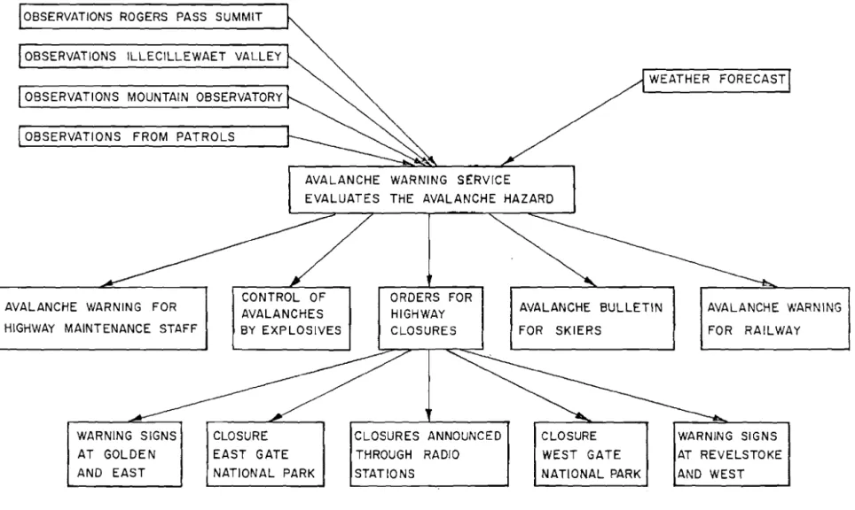
I n t h e e a r l y 1 9 5 0 f s , c o n s i d e r a t i o n was g i v e n t o t h e use of Rogers Pass a s a p o s s i b l e r o u t e t h r o u g h t h e S e l k i r k Range f o r t h e Trans-Canada Higl~tvay. The p a s s , t h e l o w e s t and s h o r t e s t r o u t e through t h e S e l k i r l c s , i s l o c a t e d between t h e
towns of Golden and Revelstolce i n B r i t i s h Columbia. The
summit of t h e B s s i s n e a r t h e town of G l a c i e r i n G l a c i e r N a t i o n a l Park ( p i g s , 1 and 2 ) .
The d i s c o v e r y of t h e Pass by Major A . B. Rogers d u r i n g h i s survey f o r t h e Canadian P a c i f i c Railway enabled t h a t company t o complete t h e f i r s t r a i l w a y l i n k between
Eas-tern Canada and t h e West Coast i n 1885. The l i n e through t h e 'Pass was used. u n t i l 1916 when it was abandoned on t h e completion of t h e Connaught Tunnel.
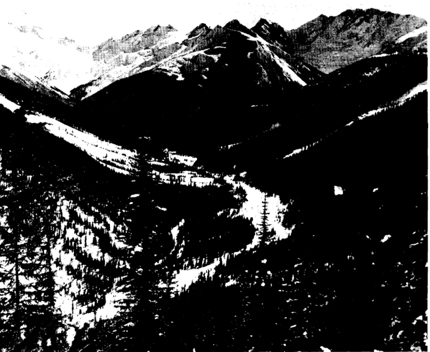
The v a l l e y s a s s o c i a t e d w i t h t h e Pass a r e narrow and have s t e e p s i d e s . Because of heavy s n o w f a l l i n t h e a r e a
w i n t e r and s p r i n g a v a l a n c h e s a r e a common o c c u r r e n c e , I n 1953, t h e Department of P u 3 l i c Ihiorlcs, r e s p o n s i b l e f o r t h e c o n s t r u c t i o n of t b e highway i n G l a c i e r N a t i o n a l P a r k , began a s t u d y of t h e l o c a t i o n of each avalanche s i t e and t h e c o n d i t i o n s under which t h e a v a l a n c h e s o c c u r , M r . N. C. Gardner was i n charge of t h e s e o b s e r v a t i o n s , I n 1956, when t h e d e c i s i o n was made t o c o n s t r u c t t h e higllv~ay throug-11 t h e P a s s , t h e Department of P u b l i c 1,filorks e s t a b l i s h e d a n avalanche o b s e r v a t i o n s t a t i o n
at G l a c i e r . The o b s e r v a t i o n program was e n l a r g e d
t o
o b t a i n t h e i n f o r m a t i o n r e q u i r e d f o r t h e s p e c i f i c a t i o n and d e s i g n of t h e defence system. An avalanche h a z a r d f o r e c a s t r o u t i n ewas e s t a b l i s h e d f o r t h e p r o t e c t i o n of t h e avalanche o b s e r v e r s , s u r v e y o r s and c o n s t r u c t i o n crew,
The N a t i o n a l Research Council, through i t s D i v i s i o i l of B u i l d i n g Research, co-operated i n t h e o r g a n i z a t i o n of t h e avalanche o b s e r v a t i o n s t a t i o n . I n i t i a l l y , t h e N a t i o n a l Research Council c o n t r i b u t e d i n f o r m a t i o n and a p p a r a t u s f o r t a k i n g t h e n e c e s s a r y weather and snow c o v e r o b s e r v a t i o n s ; when t h e a u t h o r
joined t h e Snow and I c e S e c t i o n of t h e D i v i s i o n of B u i l d i n g Research, t h e f o l l v ~ v i n g r e s p o n s i b i l i t i e s were assumed:
1. To make recommendations on t h e t y p e , l o c a t i o n and d e s i g n of t h e defence f o r each avalanche s i t e , To a s s i s t i n
I n A p r i l of 1957, t h e a u t h o r was seconded t o t h e Department of Public !Vorks and joined t h e avalanche observation s t a t i o n a t G l a c i e r on a f u l l - t i m e b a s i s . During t h e w i n t e r s 1957-1958 and 1958-1959 he was r e s p o n s i b l e f o r t h e snow cover, weather and avalanche observations t h a t were made. Based on t h e s e o b s e r v a t i o n s and o t h e r s taken p r i o r t o 1957, a defence p l a n was drawn up and reconmendations made f o r t h e defence a t each avalanche s i t e . This information i s published i n a s e p a r a t e r e p o r t (1). The recommended defence plan included highway c l o s u r e and c o n t r o l o f avalanches w i t h e x p l o s i v e s . The
e v a l u a t i o n and p r e d i c t i o n of t h e avalanche hazard i s t h e r e f o r e a necessary and i n t e g r a l p a r t of t h e avalanche defence. The National Research Council had no r e s p o n s i b i l i t y f o r t h e
o r g a n i z a t i o n of the avalanche hazard p r e d i c t i o n and warning s e r v i c e r e q u i r e d f o r t h e highway b u t it was n e c e s s a r y t o
a n t i c i p a t e t h e n a t u r e of t h i s f u t u r e s e r v i c e when e s t a b l i s h i n g t h e defence f o r each avalanche s i t e . I t was considered t h a t a record of t h e n a t u r e of t h e f u t u r e warning s e r v i c e t h a t had been i n mind when t h e recommendations were prepared f o r t h e avalanche defence works, and a record of t h e experience gained i n avalanche hazard e v a l u a t i o n and f o r e c a s t i n g f o r t h e Rogers Pass a r e a would be valuable t o t h e people r e s p o n s i b l e f o r t h e avalanche warning s e r v i c e f o r t h e completed highway. T h i s
r e p o r t c o n t a i n s t h i s record. I n
it
a r e presented:( a ) a d e s c r i p t i o n of t h e weather and snow cover observa- t i o n s -taken,
( b ) a summary of experience gained i n making t h e
avalanche hazard e v a l u a t i o n and f o r e c a s t during t h e period when t h e NRC was d i r e c t l y a s s o c i a t e d w i t h t h e f i e l d o b s e r v a t i o n s ,
( c ) a n o u t l i n e of t h e o r g a n i z a t i o n and d u t i e s of t h e f u t u r e avalanche warning s e r v i c e which had been i n mind when planning t h e complete defence system. R e s p o n s i b i l i t i e s f o r snow and weather o b s e r v a t i o n s and f o r avalanche hazard e v a l u a t i o n and f o r e c a s t were t r a n s -
f e r r e d from t h e Department of Public Works and t h e National Research Council t o t h e National Parks Branch of t h e Department of Northern A f f a i r s and National Resources on 2 October 1959.
TERRAIN
The v a l l e y s (Table I ) ad j o i n i n g Rogers Pass run i n a g e n e r a l east-west d i r e c t i o n . The mountains, mainly of q u a r t z i t e rock, with s t e e p s i d e s and bands of bold c l i f f s , r i s e between 8,000 and 10,000
f t
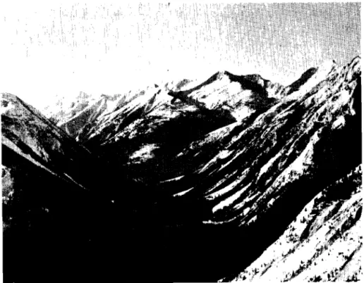
above sea l e v e l . Water hascarved numerous g u l l i e s i n t o t h e mountain s i d e s and h a s deposited decomposed rock i n a l l u v i a l f a n s i n t h e v a l l e y below. Timber
covers most of t h e mountain s i d e s below 6500 f t except f o r t h e g u l l i e s and many a r e a s where f r e q u e n t avalanches h i n d e r t h e growth of t r e e s ( F i g s . 3,
4 ,
5 ) .TABLE I
VALLEYS AND ELEVATIONS AT ROGERS PASS
-
The average width of t h e v a l l e y s i s 800 f t a t t h e bottom. A t some p l a c e s t h e mountain s i d e s approach one a n o t h e r t o form a narrow V-shaped v a l l e y w i t h t h e r i v e r flowing between t h e s t e e p t a l u s s l o p e s and s h a r p l y r i s i n g
roclcfaces. One of t h e s e narrow d e f i l e s l i e s between Mount Tupper and Mount MacDonald on t h e e a s t s i d e of Rogers Pass (Fig.
3 )
and a n o t h e r important one i s formed by t h e s i d e s of F i d e l i t y and F o r t i t u d e Mountains a t t h e west boundary of G l a c i e r National Park. Apart from two s h o r t s e c t i o n s , each 2 miles l o n g , t h e highway was constructed on t h e n o r t h s i d e of t h e v a l l e y s .1. Climate Zone.
-
A. Roch ( 2 ) h a s divided t h e mountaina r e a of t h e western United S t a t e s i n t o t h r e e d i f f e r e n t c l i m a t i c zones. The S e l k i r k Mountains a r e i n t h e n o r t h e r n e x t e n s i o n of t h e middle zone. This zone i s c h a r a c t e r i z e d by heavy snowfalls w i t h moist t o dry snow, medium temperatures which a r e only
Valley Columbia River and Beaver River Bear Creek I l l e c i l l e w a e t River E l e v a t i o n above Sea l e v e l , f t 2600 2800 2800 4 350 1500 2200 3800 4350 Location Golden t o Beaver River junction Beaver River junction t o Rogers Pass Summit Revelstoke t o A l b e r t Canyon t o G l a c i e r -to
Rogers Pass Sumrnit
Distance, m i l e s 40
7
20 1 8 1.6occasionally below O°F and s t r o n g winds on t h e mountains.
2. Snowfall.
-
Rogers Pass i s i n one of t h e h i g h e s t s n o v ~ f a l l a r e a s i n Canada. The average t o t a l snowfall f o r t h e w i n t e r , measured a t G l a c i e r over a 30-year period between1321 and 1950, i s 342 i n . The maximum t o t a l snowfall observed was 680 i n . measured i n t h e w i n t e r of 1953-54.
A t t h e 4000-ft l e v e l of t h e v a l l e y snowfall u s u a l l y begins a t t h e end of October and ceases a t t h e end of April.
Summer snowfalls may occur on t h e mountains a t 7000
f t ,
b u t t h i s soon melts. A t t h i s a l t i t u d e , f o r a n average y e a r , snow covers t h e ground from t h e end of September u n t i l the end of June.There a r e no y e a r l y r e c u r r i n g periods of maximum snowfall i n t e n s i t y . Snowfalls have been recorded d a i l y f o r one month and periods of t w o weeks d u r a t i o n have passed with- out snowfall. Storms w i t h heavy snowfalls a r e i n f r e q u e n t . During w i n t e r s of l i g h t snovifall two storms may occur y i e l d i n g 12 i n . of snow i n a 24-hr period. Winters of heavy snowfall produce 8 t o 10 such storms. A snowfall of more t h a n 20 i n . i n 24 h r i s a r a r e occurrence.
The magnitude and t h e frequency of t h e 24-hr snow- f a l l s a t G l a c i e r during t h e w i n t e r s between 1953 and 1960 a r e shown i n Table 11.
TABLE I1
FREQUENCY OF SNO\VPALLS AT GILACIER
o Records of t h e w i n t e r 1954-55 include only snowfalls a f t e r
1 January 1955. Winter 1953/54 1954/55 1955/56 1956/57 1957/58 1958/59 1359/60 T o t a l Snowfall of t h e Winter i n . 680 310 336 341 321 442 368 Number of Days with Snowfalls
Less than 4 i n . 56 35" 42 47 74 85 84 More than 20 i n . 2
-
-
1-
-
-
4 t o 1 2 i n . 44 17* 30 17 26 41 29 1 2 t o 20 i n . 7-
-
3 1 3 1Storms with a h i g h snowfall r a t e a r e u s u a l l y of s h o r t d u r a t i o n . A day with heavy s n o v ~ f a l l i s normally followed by
a period of l i g h t snowfall. Records from 1930 t o 1960 show
t h a t t h e maximum t o t a l snowfall a t G l a c i e r f o r a 5-day period was j u s t under 70 i n .
It i s p o s s i b l e t h a t once i n 20 y e a r s a w i n t e r with very heavy s n o ~ ~ f a l l could occur when t h e above-mentioned snow- f a l l amounts a r e exceeded. On 21 January 1935, 35 i n . of snow were recorded i n a 24-hr p e r i o d , b u t t h i s extreme r a t e h a s n o t been observed s i n c e .
3. Temperature.
-
The mean monthly w i n t e r temperaturesa t G l a c i e r f o r t h e
30-yr
period 1921 t o 1950 a r e given i n Table 111.TABLE I11
MEAN
TEPIIPERATURES OF THE WINTER MONTHSThe temperature i s below OOP only a few times d u r i n g t h e
w i n t e r and t h i s cold weather u s u a l l y does n o t continue f o r more t h a n a week. The lowest temperature e v e r measured a t G l a c i e r was -33OP.
The temperature d u r i n g a snowstorm normally ranges between 20 and 32OF. A f t e r a s t o m has ended it i s u s u a l f o r t h e cloudy weather t o continue and t h e temperature t o change r e l a t i v e l y slowly, The temperature f r e q u e n t l y r i s e s d u r i n g a
snowstorm and t h e snowfall i n t h e v a l l e y s changes t o r a i n . MeanTemperature,
OP
4. Wind.
-
Most snorrfalls a r e accompanied by s o u t h e r l y and w e s t e z : m i n d s of v a r i a b l e speed. Large amounts of snowcan d r i f t over t h e mountain r i d g e s and be deposited on t h e l e e s i d e . Heavy s n o v ~ f a l l s may occur w i t h no s i g n i f i c a n t wind,
Peb. 18.6
AVALANCHES AT ROGERS PASS Nov.
25,2
F i r s t s t u d i e s r e v e a l e d t h a t t h e avalanche hazard t o t h e highviay through Rogers Pass would be h i g h and would equal
March 26.8 Dec. 17.5 A p r i l 35.8 Jan. 13.6
t h e worst c o n d i t i o n s encountered on highways and r a i l r o a d s kept open during t h e w i n t e r i n t h e mountainous a r e a s of
Switzerland, A u s t r i a and Western United S t a t e s , The highway would have t o c r o s s t h e f o l l o w i n g number of avalanche paths:
9 s i t e s where avalanches of dangerous s i z e occur more than once each w i n t e r .
21 s i t e s where avalanches of minor s i z e occur once o r more t h a n once each w i n t e r . Large avalanches occur o c c a s i o n a l l g , b u t n o t every w i n t e r .
1 3 s i t e s where avalanches occur only under severe con- d i t i o n s and n o t every w i n t e r . The avalanches would be l a r g e i n most c a s e s .
31 s i t e s where avalanches occur only o c c a s i o n a l l y under severe c o n d i t i o n s . The snow t h a t would r e a c h t h e highway would u s u a l l y be a i r b o r n e and l i t t l e would be deposited on t h e highway.
TOTAL
74 avalanche s i t e s ,
I n t h i s r e p o r t , t h e l o c a t i o n of t h e avalanche s i t e
i s given by t h e highway mileage from t h e e a s t boundary of G l a c i e r National Park. Most of t h e s i t e s have a name and have been f u l l y described (1)-
The avalanche hazard i s v e r y high a t t h e two
d e f i l e s where t h e v a l l e y has a narrow V-shape and t h e highway
i s l o c a t e d a t t h e bottom of t h e l o n g , s%eep mountain s i d e . These two most a c t i v e avalanche a r e a s a r e l o c a t e d :
( a ) Below Mount Tupper between Mile 1 0 and Mile 1 3 ( F i g s .
3
and4 ) .
( b ) On t h e south s i d e of F i d e l i t y Mountain immediately west .of G l a c i e r National Park.
Avalanches may reach t h e highway a t both s e c t i o n s during and a f t e r every s i g n i f i c a n t snowfall, p a r t i c u l a r l y a f t e r snowfalls of more t h a n 1 0 i n . accompanied by wind,
Between and o u t s i d e t h e two a r e a s , t h e avalanche s i t e s a r e more s c a t t e r e d and t h e v a l l e y f l o o r i s wider ( F i g s . 2 and
5 ) .
Avalanches r e a c h t h e highway only under bad condi- t i o n s . Dangerous ones u s u a l l y occur a f t e r snowfalls of more t h a n 24 i n . and d u r i n g t h e snow melting period.Periods of Avalanche A c t i v i t y
There a r e two avalanche p e r i o d s each year, I n t h e f i r s t p e r i o d , between e a r l y November and l a t e February,
avalanches a r e caused mainly by snoivfalls
,
wind a c t i o n , and r a i n i n a s s o c i a t i o n w i t h snoi8ifalls. I n t h e second p e r i o d , between l a t e Idarch and mid-May, avalanches a r e caused mainly by warm weather and melting of t h e snow,Records of t h e avalanches a f f e c t i n g t h e railway l i n e between t h e years 1910 and 1952 were s t u d i e d i n t h e o f f i c e of t h e Division Engineer of t h e Canadian P a c i f i c Railway a t Revelstoke, The study revealed a cycle of some y e a r s of
heavy a c t i v i t y followed by y e a r s of few avalanches, Avalanches a f f e c t i n g t h e railway l i n e between Stoney Creek and t h e e a s t
p o r t a l of Connaught h e l , and between t h e west p o r t a l of t h e t u n n e l and I l l e c i l l e w a e t s i d i n g d u r i n g t h e period 1910-1960
a r e p l o t t e d i n Fig, 6 , The graph shows periods of h i g h avalanche a c t i v i t y with maxima 1920, 1935 and 1952, The observations
r e q u i r e d f o r t h e defence planning of t h e highway appear t o have been made during a period of low avalanche a c t i v i t y ,
SOME FUNDAMENTAL CONSIDERATIONS TO THE AVALANCHE HAZARD
EVALUATION AND PREDICTION
The technique of observing d i f f e r e n t snow and weather f a c t o r s and e v a l u a t i n g from them t h e l i k e l i h o o d of
avalanche occurrences i s c a l l e d "avalanche hazard f o r e c a s t i n g w by t h e U,S, F o r e s t Service, An avalanche i s caused by
d i f f e r e n t f a c t o r s which a r e i n t e r r e l a t e d c l o s e l y . C e r t a i n r u l e s have been e s t a b l i s h e d through experience concerning t h e dependence of t h e avalanche hazard on t h e s e f a c t o r s , b u t t h e f o r e c a s t i n g of avalanches i s s t i l l a n a r l - , r a t h e r than a science. It r e q u i r e s a c e r t a i n s k i l l which i n c l u d e s a thorough understanding of t h e behaviour of snow on t h e ground, t h e
t e r r a i n , t h e weather i n t h e mountains, and t h e i r i n t e r -
r e l a t i o n s h i p . -)
The hazard can be evaluated q u i t e a c c u r a t e l y f o r t h e time of observation, b u t t h e p r e d i c t i o n of t h e f u t u r e hazard i s only a s good a s t h e weather f o r e c a s t , I n p r a c t i c e , t h e avalanche hazard f o r e c a s t e r has t o assume t h a t t h e weather w i l l follow a c e r t a i n p a t t e r n and h i s p r e d i c t i o n i s based on t h i s .
The a u t h o r , f a m i l i a r with t h e S w i s s method of
avalanche hazard f o r e c a s t i n g , was pleased t o have t h e oppor- t u n i t y t o co-operate with people who received t h e i r t r a i n i n g i n avalanche hazard f o r e c a s t i n g from t h e United S t a t e s F o r e s t s e r v i c e , During f r e q u e n t d i s c ~ s s i o n s
i t
became e v i d e n t t h a tt h e e v a l u a t i o n of t h e avalanche hazard can be approached by two d i f f e r e n t methods, t h e t e s t i n g method and t h e a n a l y t i c method.
The T e s t i n g Method
The t e s t i n g method i s t h e b a s i s of technique used by t h e Swiss Snow and Avalanche Research I n s t i t u t e , and i s widely used f o r avalanche warning i n o t h e r c o u n t r i e s
( 3 ) .
Theavalanche hazard f o r e c a s t i s based on snow cover observations. These o b s e r v a t i o n s , u s u a l l y c a l l e d t h e snow p r o f i l e , show i f
t h e r e a r e u n s t a b l e l a y e r s which raigJbt c o l l a p s e and cause
avalanches. The s t a b i l i t y of t h e snow cover can be t e s t e d a t any time when t h e c o n d i t i o n s warrant it. Weather f a c t o r s such a s snowfall, wind and t e n p e r a t u r e a r e used t o determine i t s
s t a b i l i t y between observations. Experience and t e s t s have
sho-m which f a c t o r s may l e a d t o a f r a c t u r e and which c o n d i t i o n s c o n t r i b u t e t o s t a b i l i z a t i o n . The s i m 2 l e s t a p p l i c a t i o n o f t h e t e s t i n g method i s t h e d i r e c t t e s t i n g of t h e s t a b i l i t y of a s l o p e .
This t e s t i n g method has t h e f o l l o w i n g advantages: ( a ) The a c t u a l m a t e r i a l , t h e snow on t h e ground, i s
s t u d i e d . This m a t e r i a l can be observed by anyone and i t s c o n d i t i o n s a r e c l e a r l y v i s i b l e .
( b ) It i s u n i v e r s a l and can be a p p l i e d t o any avalanche
a r e a .
llountain climbers and f e e l i n g f o r snow need recognize whether t h e l i k e l y t o s l i d e .
slciers who u s u a l l y have a only l i t t l e t r a i n i n g t o snow on a given s l o p e i s The disadvantages of t h e t e s t i n g method a r e : ( a ) I n a c c u r a t e deterinination of t h e avalanche hazard
i f t h e s t a b i l i t y of t h e s l o p e s i s n o t t e s t e d con- t i n u o u s l y .
( b ) A b a s i c understanding of snow behaviour under
d i f f e r e n t weather c o n d i t i o n s and t e r r a i n i s r e q u i r e d . The Analytic Method
The a n a l y t i c method has been developed mainly by t h e U.S. P o r e s t Service ( 4 ,
5 ) .
It was found t h a t most avalanches a r e caused by snowfalls and occur e i t h e r d u r i n go r immediately a f t e r storms. A method was developed, t h e r e f o r e , by which t h e occurrence of t h e s e d i r e c t a c t i o n avalanches
could be f o r e c a s t e d a c c u r a t e l y . A number of d i f f e r e n t con- t r i b u t i n g f a c t o r s have t o be observed and t h e avalanche hazard i s evaluated from t h e magnitude of each f a c t o r . The s t a b i l i t y of t h e o r i g i n a l snon cover i s only one of t h e s e , The i n f l u e n c e of each f a c t o r i s found by a n a l y z i n g
Lhc
avalanche c o n d i t i o n s over a few winters. The ? o r e c a s t i n g l ~ l @ si.n
t l i i s repo?.d fo,- s p r i n g thaw avalanches, and a l s o f o r Mount Green and Crossovar avalanchesa r e examples of t h e a n a l y t i c method (Appendices I V , V ) . This method i s s i m i l a r t o t h a t used i n f o r e c a s t i n g t h e f o r e s t f i r e hazard.
The a n a l y t i c method has t h e following advantages :
( a ) Good r e s u l t s a r e obtained f o r t h e f o r e c a s t of d i r e c t a c t i o n avalanches. The chances of whether o r n o t a d i r e c t a c t i o n avalanche w i l l occur can be p r e d i c t e d more a c c u r a t e l y t h a n by t h e t e s t i n g method,
( b ) A f t e r many y e a r s of experience r u l e s can be found t o e v a l u a t e t h e hazard f o r a given avalanche a r e a , These r u l e s can o f t e n be a p p l i e d by a n observer w i t h a l i t t l e t r a i n i n g . Rules f o r t h e time when avalanches should be c o n t r o l l e d by e x p l o s i v e s can a l s o be e s t a b - l i s h e d and be a p p l i e d by t h e people i n charge of t h i s
defence
.
( c ) The method i s s u i t a b l e f o r p r e d i c t i n g t h e avalanche hazard when a n a c c u r a t e weather f o r e c a s t i s a v a i l a b l e . The method has t h e f o l l o w i n g disadvantages:
( a ) Many weather o b s e r v a t i o n s a r e r e q u i r e d , Numerous instruments and f r e q u e n t observations may make
avalanche hazard f o r e c a s t i n g appear t o be a s p e c i a l s c i e n c e . Amateurs, such a s s k i e r s , may be d i s - couraged from o b t a i n i n g t h e knowledge on avalanche occurrences n e c e s s a r y f o r t h e i r orm s a f e t y ,
( b ) The method cannot p r e d i c t some delayed a c t i o n avalanches caused by changes i n t h e snow cover, u n l e s s t h e observers c o n s i d e r very c a r e f u l l y t h e s t a b i l i t y of t h e snow cover.
( c ) There i s a danger t h a t avalanche f o r e c a s t i n g w i l l
become a mechanical process and human good sense w i l l be l o s t . The f a c t o r s t h a t cause avalanches a r e r e l a t e d i n such a complex way t h a t it i s
impossible t o a c c u r a t e l y e x p r e s s t h i s r e l a t i o n s h i p a n a l y t i c a l l y , a s t h e r e a r e always odd c o n d i t i o n s t o which t h e r u l e s cannot be a p p l i e d .
( d ) The value of f a c t o r s causing t h e avalanches i n one a r e a may n o t be t h e same i n a n o t h e r a r e a . Experience gained through o b s e r v a t i o n s over a few w i n t e r s i s u s u a l l y r e q u i r e d before t h i s method can be a p p l i e d t o any s i t e .
I,!Iost avalanche warning s e r v i c e s use both methods. The avalanche hazard i s b a s i c a l l y evaluated w i t h t h e t e s t i n g method, and supplemented by t h e a n a l y t i c method t o improve t h e accuracy. During t h e survey, t h e avalanche hazard on Rogers Pass was evaluated and p r e d i c t e d mainly by t h e t e s t i n g method, vri-bh good r e s u l t s . Rules could be e s t a b l i s h e d a t some s i t e s which allowed a more a c c u r a t e e v a l u a t i o n o f t h e avalanche hazard. The experience obtained i n e v a l u a t i n g t h e avalanche hazard and t h e r u l e s e s t a b l i s h e d a r e recorded i n t h i s r e p o r t .
I t i s hoped t h a t t h i s record w i l l a s s i s t t h e Rogers Pass
Avalanche Hazard Evaluation and F o r e c a s t i n g Group i n developing a working combination of t h e t e s t i n g and a n a l y t i c methods.
ORGANIZLlTIOIT OP THE OBSERVATIONS Snow 2nd Weather Observations
The headquarters f o r t h e avalanche o b s e r v a t i o n s t a t i o n was a t G l a c i e r i n t h e camp of t h e Department of 32u'olic Worlrs. This st;ation made t h e r e q u i r e d o b s e r v a t i o n s on t h e snow cover and weather, surveyed t h e avalanches t h a t occurred, and prepared t h e avalanche hazard f o r e c a s t .
The f i r s t problem vras t o s e l e c t t h e s i t e s f o r snow and weather observations. The i d e a l observatory should be l o c a t e d n e a r t h e r u p t u r e zone of t h e avalanches v~herz th e observations a r e r e p r e s e n t a t i v e of t h e avalanche a r e a . S t a f f accommodation should be n e a r t h e o b s e r v a t i o n a r e a s o t h a t
observations can be c a r r i e d ou-b continuously and s p e c i a l measurements made a t any r e q u i r e d time, This i d e a l s i t e would be on t h e mountains between GOO0 and 7000 f t above sea l e v e l and 3000 f t h i g h e r t h a n -the v a l l e y , w i t h a b u i l d i n g f o r t h e s t a f f and a c c e s s by road o r a e r i a l t r a m a y , Because time and funds were n o t a v a i l a b l e f o r tlie c o n s t r u c t i o n of such a major p r o j e c t , and t h e su-rvey of t h e avalanches a l o n g t h e f u t u r e highway was t h e inore import-ant t a s k , it was
decided t o e s t a b l i s h t h e avalanche o b s e r v a t i o n s t a t i o n i n t h e v a l l e y . S i t e s a e r e chosen f o r d a i l y observations and two a d d i t i o n a l s i t e s were choser a t t h e a l t i t u d e of t h e avalanche r u p t u r e zone a t which r e g u l a r weekly observations o r d a i l y could be made, when c o n d i t i o n s vrananted it. The p r i n c i p l e of keeping t h e number of ~ S s e r v a t i o n s w i t h i n t h e c a p a c i t y of t h e observation group i*Jas a p p l i e d a t a l l -Limes, Experience shoiired t h a t d a i l y observsL'io;zs should be kept t o a rriinimum b u t t h a t t h e y should be r e l i a b l e and complete. A d e s c r i p t i o n
Rogers Fass Summit.
-
The summit o f Rogers Pass was chosen a s-
t h e c e n t r a l observatory where a l l b a s i c observations were made. It was l o c a t e d a t a n a l t i t u d e of 4300 f t i n t h e middle
o f t h e 1200-ft wide v a l l e y runs from south t o n o r t h (Fig. 2 ) . Prom t h i s l o c a t i o n t h e weather c o n d i t i o n s on both s i d e s of t h e pass could be observed. It was assumed t h a t t h e f u t u r e headquarters of t h e highway maintelzance s t a f f and t h e avalanche warning s e r v i c e would be l o c a t e d a t t h e summit of t h e p a s s , and it would be an advantage t o have t h e observatory c l o s e a t hand. A t e s t p l o t 100 by 150 f t with a small s h e l t e r
and
i n s t r u n e n t stand was e s t a b l i s h e d - i n October 1957 andobservations began i n t h e w i n t e r of 1957-1958 (Fig.
7 ) .
Daily observations were made between 8 and 1 0 a.m. by p a t r o l s from Glacier.Rogers Pass Summit i s moderately exposed t o wind;
observations on t h e depth of new snow had t o be made i n a s h e l t e r e d a r e a behind t h e cabin. A p r o t e c t i v e fence was
e r e c t e d around t h e a r e a where t h e snow cover was s t u d i e d , b u t
it was s t i l l d i s t u r b e d by animals, p a r t i c u l a r l y b e a r s . Glacier.
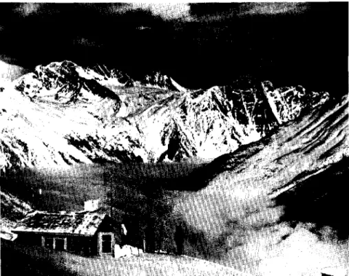
-
The survey camp a t G l a c i e r on t h e west s i d e of Rogers Pass, 3800 f t above sea l e v e l , was t h e headquarters of t h e s t a f f making t h e avalanche observations (Fig. 8 ) . It w a sl o g i c 6 1 t h a t continuous weather and snow o b s e r v a t i o n s should be made n e a r t h e camp, p a r t i c u l a r l y when temperature and
~ r e c i ~ i t a t i o n observations have been made a t G l a b i e r f o r t h e p a s t 40 years. Twice d a i l y observations taken a t G l a c i e r i n d i c a t e d t h e weather c o n d i t i o n s on t h e west s i d e of Rogers - Fass.
P l a t Creek.
-
P l a t Creek i s a park warden s t a t i o n on t h e west-
s i d e of Rogers Bss,9
miles from t h e summit a t an a l t i t u d e of3100 f t . Daily observations were taken t h e r e by t h e warden on a p l o t c l o s e t o h i s house.
The purpose of t h e s e o b s e r v a t i o n s was t o determine any d i f f e r e n c e between t h e c o n d i t i o n s i n t h e I l l e c i l l e w a e t Valley and those observed a t G l a c i e r and a t t h e summit.
Stone7 Creek.
-
Stoney Creek i s a park warden s t a t i o n on t h e-
e a s t s i d e of Rogers Pass, 6 miles f r o m t h e summit and 3650 f t above sea l e v e l . Daily observations were taken t h e r e by t h e warden on a p l o t c l o s e t o h i s house.
The purpose of t h e s e o b s e r v a t i o n s was t o determine any s i g n i f i c a n t d i f f e r e n c e between t h e c o n d i t i o n s observed on t h e summit and on t h e e a s t s i d e of t h e pass.
1101;mt Abbott.
-
P o s s i b l e s i t e s f o r a rnountain observatory a r e7 . -
-
discussed i n Appendix I. Nount Abbott, 6800
f t
above seat r a i l was a v a i l a b l e , and a c c e s s i n w i n t e r was s h o r t ( P i g . 2 ) .
A c a b i n was b u i l t t h e r e i n September 1956 ( F i g . g ) , and a
t e s t p l o t was e s t a b l i s h e d on a t e r r a c e 200 f t below t h e c a b i n .
A r a d i o telephone connected t h e o b s e r v a t o r y w i t h t h e head-
q u a r t e r s a t G l a c i e r . m e o b s e r v a t o r y was occupied c o n t i n u o u s l y d u r i n g t h e w i n t e r of 1956-57, b u t o n l y d u r i n g storms and t h e snow-melt period i n t h e f o l l o w i n g two w i n t e r s . Weekly
i n s p e c t i o n s were made when no o b s e r v e r l i v e d t h e r e . The o b s e r v a t i o n s t a k e n a t Mount Abbott i n d i c a t e d t h e snow cover and t h e weather c o n d i t i o n s a t t h e a l t i t u d e o f t h e r u p t u r e zone f o r t h e avalanches.
Balu Pass.
-
A second mountain o b s e r v a t o r y was e s t a b l i s h e d a t Balu Pass, 6600 f t above s e a l e v e l (Fig. 1 0 ) . T e s t p l o t s were s t a k e d o u t on b o t h s i d e s of t h e p a s s where t h e snow p r o f i l e was surveyed monthly d u r i n g t h e w i n t e r 1957-1958. Ac a b i n was b u i l t a t t h e summit of t h e pass i n September 1958. This o b s e r v a t o r y served p r i m a r i l y f o r wind o b s e r v a t i o n s a s Mount Abbott was a n u n s a t i s f a c t o r y s i t e f o r such measurements.
The wind speed and d i r e c t i o n were measured w i t h a s t a n d a r d anemovane and recorded on a n E s t e r l i n e Angus r e c o r d e r i n December 1958 and J a n u a r y 1959. S p e c i a l wind t e l e m e t e r i n g equipment was developed f o r t h i s o b s e r v a t o r y by t h e Radio and E l e c t r i c a l Engineering D i v i s i o n , NRC, and i n s t a l l e d i n September 1959 ( 6 ) . Information on t h e wind speed and d i r e c t i o n was
t h u s t r a n s m i t t e d t o G l a c i e r by r a d i o . The s t a t i o n performed w e l l i n t h e f o l l o w i n g w i n t e r , and needed o n l y o c c a s i o n a l
i n s p e c t i o n . The absence of i c i n g on t h e anemovane o f f e r e d some encouragement t h a t t h e wind equipment might be i n s t a l l e d on a more exposed and remote mountain w i t h d i f f i c u l t a c c e s s , e . g . , on t h e r i d g e of Mount Abbott.
An e x t e n s i v e s t u d y on t h e c o n d i t i o n s c a u s i n g s p r i n g thaw avalanches was conducted a t Balu Pass i n May 1959.
Observations a t Rogers Pass Summit and a t G l a c i e r
The d e s c r i p t i o n of t h e equipment and rnetliods used f o r t h e snow cover and weather o b s e r v a t i o n s a r e given i n Appendix 11. The f o l l o w i n g d a i l y o b s e r v a t i o n s were t a k e n a t
t h e two o b s e r v a t o r i e s :
A i r temperature :
-
d a i l y maximum temperature-
d a i l y minimum temperature-
temperature a t t h e time of o b s e r v a t i o n P r e c i p i t a t i o n :-
d e p t h of new snow-
d e n s i t y o r s p e c i f i c g r a v i t y of new snow-
t o t a l s n o w f a l l from t h e beginning of a storm ( s t o r m s t a k e )-
s e t t l e m e n t of new snow-
r a i n f a l l Snow cover: Wind : S t a t e of t h e Weather-
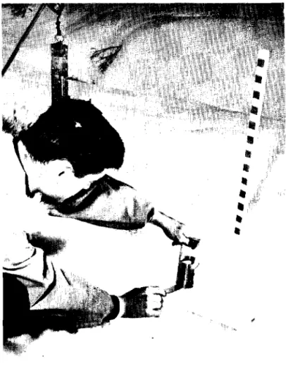
t o t a l snow d e p t h-
s e t t l e m e n t of t h e snow c o v e r-
snow temperature-
s u r f a c e of t h e snow ( e . g . s o f t , c r u s t )-
d e p t h of p e n e t r a t i o n of a f o o t p r i n t o r d e p t h of p e n e t r a t i o n of t h e f i r s t s e c t i o n of t h e ramsonde-
a s h a l l o w snowpit was dug and t h e h a r d - n e s s and s h e a r s t r e n g t h of t h ed i f f e r e n t snow l a y e r s were t e s t e d whenever such o b s e r v a t i o n s were r e q u i r e d
-
windspeed-
wind d i r e c t i o n-
o b s e r v a t i o n s on t h e d i r e c t i o n and t h e magnitude of snow movements on mountain r i d g e s (snow f l a g s ) and i n t h e v a l l e y whenever v i s i b i l i t yp e r m i t t e d .
D a i l y o b s e r v a t i o n s on p r e c i p i t a t i o n and a i r tempera- t u r e were continued d u r i n g t h e summer.
The complete p r o f i l e of t h e snow c o v e r was surveyed twice a month on Rogers Pass Summit.
Observations a t F l a t Creek and Stoney Creek
The f o l l o w i n g d a i l y o b s e r v a t i o n s were t a k e n a t t h e two p a r k warden s t a t i o n s :
-
maximum t e m p e r a t u r e-
minimun temperature-
d e p t h of new snow-
t o t a l snowfall from b e g i n n i n g of a storm-
r a i n f a l l-
t o t a l snow d e p t hObservations were n o t made on some days d u r i n g t h e w i n t e r and measurements were d i s c o n t i n u e d d u r i n g t h e summer.
Observations on Mount Abbott
The same d a i l y observations made a t Rogers Pass Summit and a t G l a c i e r were made, on llount Abbott when t h e observatory was occupied. A t o t h e r t i m e s , p r e c i p i t a t i o n and temperature were measured w i t h recording i n s t r u u e n t s . The snow p r o f i l e was surveyed weekly.
S p e c i a l Observations
The r u p t u r e zones of avalanches were v i s i t e d when- e v e r t h e avalanche hazard made such v i s i t s f e a s i b l e . The p r o f i l e s of t h e snow cover i n t h e s e a r e a s were s t u d i e d and compared w i t h t h e p r o f i l e s taken a t Rogers ?ass Summit and
Mount Abbott
.
Records
A l l observations were recorded on s p e c i a l forms
( i s 11, 1 2 ,
13).
The observations on t h e snow cover and t h e weather were p l o t t e d a g a i n s t time. A l l r e c o r d s were s t o r e d a t t h e avalanche observation s t a t i o n a t G l a c i e r and were t r a n s f e r r e d t o t h e Department of Northern A f f a i r s and National Resources on 2 October 1959.Survey of t h e avalanches
Recording a l l avalanches along t h e proposed highway was t h e primary work of t h e avalanche o b s e r v a t i o n s t a t i o n .
These avalanches were surveyed f r e q u e n t l y by p a t r o l s and
recorded i n a s p e c i a l book. Those d e p o s i t i n g snow n e a r o r on t h e highway right-of-way were t r a c e d on l o c a t i o n plans. The l o c a t i o n of t h e f r a c t u r e zone and t h e path of some important avalanches were t r a c e d on photographs ( P i g ,
1 4 ) .
It was important t o know n o t only t h e d a t e b u t t h e
hour when t h e avalanches had occurred. The time could be
obtained f a i r l y a c c u r a t e l y by d a i l y and o f t e n twice d a i l y p a t r o l s between Mile
11.5
and 1 7 , and p a t r o l s through o t h e r a r e a s when avalanches could be expected.Personnel
The s t a f f of t h e avalanche observation s t a t i o n averaged s i x men d u r i n g t h e w i n t e r and t h r e e d u r i n g t h e
summer. These numbers were r e q u i r e d f o r s a f e t y reasons. F a t r o l s through avalanche a r e a s should be done by a t l e a s t two o r more men. A t l e a s t two should be a t t h e mountain observatory when occupied d u r i n g storm p e r i o d s .
I t was foimd t h a t h a l f of t h e s t a f f should have a good knowlkdge of s k i i n g and be experienced i n mountain
t r a v e l . The o t h e r s need only a f a i r knowledge i n s k i i n g b u t must be p h y s i c a l l y f i t f o r t h e work.
CAUSES OP THE AVALANCHES
Observations showed t h a t avalanches a r e caused by
t h e same f a c t o r s a s i n o t h e r c o u n t r i e s s o t h a t experience gained by o t h e r o r g a n i z a t i o n s i n t h e f o r e c a s t i n g o f avalanches can
be a p p l i e d t o Rogers Pass. I n t h i s s e c t i o n , t h e f a c t o r s which c o n t r i b u t e t o t h e development of avalanches a r e summarized and those of p a r t i c u l a r importance f o r t h e avalanche hazard f o r e - c a s t a t Rogers Pass a r e emphasized, T h i s summary i s n o t meant t o be a general handbook on avalanche hazard f o r e c a s t i n g ; it i s addressed t o those who r e q u i r e an i n t r o d u c t i o n t o t h e con- d i t i o n s a t t h e pass. The r u l e s t h a t a r e given h e r e a r e based on a l l a v a i l a b l e o b s e r v a t i o n s and can probably be improved with more experience.
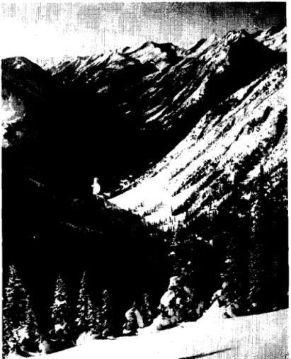
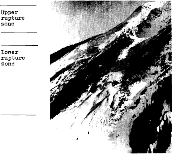
Rupture Zones
Rogers Fass has an upper and lower zone from which avalanches can s t a r t t o s l i d e . A t e r r a c e with a s l i g h t i n c l i n e , l o c a t e d between 5500 and 6500 f t d i v i d e s t h e s e t w o zones on
many of t h e mountain s l o p e s ( P i g s . 15, 1 6 ) . &lost avalanches s t a r t i n g t o s l i d e i n t h e lower zone r u p t u r e on t h e c l i f f s o r a t t h e t o e o f c l i f f s . The upper zone c o n t a i n s s t e e p s l o p e s r i s i n g from 6500 f t t o t h e mountain r i d g e s . Many small avalanches t h a t o r i g i n a t e i n t h e upper zone s t o p on t h e
t e r r a c e between t h e two zones. A knowledge of t h e two d i f f e r - e n t r u p t u r e zones i s important t o p r e d i c t avalanches caused by high temperatures. I t was observed f r e q u e n t l y t h a t t h e
temperature in t h e lower zone was h i g h enough t o cause avalanches, whereas i n t h e upper zone t h e temperature was s o low t h a t t h e
snow was s t i l l s t a b l e , Climate Areas
A t Rogers Pass t h e r e a r e two major c l i m a t e a r e a s ,
and t h e avalanche hazard f o r each should be evaluated s e p a r a t e l y . The two a r e a s a r e :
-
t h e Tupper a r e a on t h e e a s t s i d e of t h e P a s s ,-
t h e I l l e c i l l e w a e t Valley on t h e west s i d e of t h e Pass.Most snowstorms approach t h e Pass from t h e west and southwest and d e p o s i t a g r e a t e r amount of new snow i n t h e I l l e c i l l e w a e t Valley t h a n i n t h e Tupper a r e a . Observations d u r i n g t h e two w i n t e r s between 1957 and 1959 showed t h a t t h e average t o t a l s n o w f a l l i n t h e Tupper a r e a was 80 p e r c e n t of 3
t h e snowfall measured i n t h e I l l e c i l l e w a e t - Valley. A s l e s s s n o w f a l l i s r e q u i r e d t o cause avalanches on Mount Tupper, t h e avalanche hazard i s u s u a l l y about e q u a l i n b o t h a r e a s .
Occasional storms from t h e n o r t h and e a s t d e p o s i t more snow i n t h e Tupper a r e a t h a n on t h e west s i d e of Rogers Pass.
Observations a t t h e s u m m i t give a good i n d . i c a t i o n of weather c o n d i t i o n s on t h e e a s t s i d e of Rogers Pass. A
s p e c i a l o b s e r v a t o r y i n Stoney Creek i s n o t e s s e n t i a l , b u t
a d d i t i o n a l o b s e r v a t i o n s on t h e e a s t s i d e of Mount Tupper would be u s e f u l f o r a c o n t r o l .
Generally h i g h e r p r e c i p i t a t i o n on t h e west s i d e of Rogers Pass t h a n t h a t measured a t t h e summit; i n d i c a t e s a need f o r a d d i t i o n a l weather o b s e r v a t i o n s on t h e west s i d e , e i t h e r a t G l a c i e r o r a t F l a t Creek. The d i f f e r e n c e i n p r e c i p i t a t i o n a t G l a c i e r and a t F l a t Creek i s n o t s i g n i f i c a n t . Since F l a t Creek i s a l i t t l e warmer, r a i n sonetimes f a l l s h e r e when t h e r e i s s n o w f a l l a t G l a c i e r . G l a c i e r i s , t h e r e f o r e , a more s u i t a b l e s t a t i o n f o r weather o b s e r v a t i o n s w i t h t h e a d d i t i o n a l advantage of having been a c l i m a t o l o g i c a l s t a t i o n f o r o v e r 40 y e a r s . The Snow Cover
Frequent s n o w f a l l s w i t h f a i r l y c o n s t a n t t e m p e r a t u r e s d u r i n g and a f t e r each s n o w f a l l u s u a l l y produce a s t a b l e snow cover. The t y p i c a l snow p r o f i l e h a s l a y e r s w i t h i n c r e a s i n g s t r e n g t h toviard t h e ground ( F i g . 1 3 ) . Snow w i t h a h i g h d e g r e e of metamorphism ( d e p t h h o a r , s u g a r snow) forming l a y e r s w i t h low s t r e n g t h a r e n o t o f t e n observed. Unstable l a y e r s c a u s i n g avalanches may develop from t h e f o j ~ o w i n ~ c o n d i t i o n s :
( a ) Snow c o v e r s t h e mountains i n September and e a r l y October, and cold w e a t h e r w i t h l i t t l e s n o w f a l l p e r s i s t s d u r i n g October and November. The snow i n t h e avalanche r u p t u r e zones changes i n t o depth h o a r t h u s c r e a t i n g a n u n s t a b l e base f o r f u t u r e s n o v ~ f a l l s . This s i t u a t i o n i s t y p i c a l f o r t h e Rocky Mountain
a r e a b u t a p p e a r s only o c c a s i o n a l l y i n t h e S e l k i r k s . I t was observed i n t h e Rogers Pass a r e a i n t h e w i n t e r of 1957-58, b u t t h e u n s t a b l e snow covered s m a l l a r e a s only.
( b ) Cold weather i n J a n u a r y and February w i t h a p e r i o d of no s n o w f a l l f o r two o r more weeks may cause con- s i d e r a b l e me-tamorphism of t h e snow a t t h e s u r f a c e .
T h i s snow l a y e r h a s low cohesion and may f r a c t u r e l a t e r under t h e weight of new snow o r d u r i n g t h e
snow-melt period. Such a c o n d i t i o n was observed i n February 1957 and was t h e cause of numerous s p r i n g thaw avalanches i n ?flay of t h a t y e a r .
( c ) A period of r a i n o r sunshine occurs r e s u l t i n g i n a c r u s t which forms a s l i d i n g s u r f a c e f o r w i n t e r
a n d s p r i n g a v a l a n c h e s , p a r t i c u l a r l y i n t h e lower r u p t u r e zone.
Although u n s t a b l e l o o s e l a y e r s a r e i n f r e q u e n t l y observed i n t h e Rogers Pass a r e a , t h e snow p r o f i l e proved t o be important a s t h e b a s i s f o r t h e d a i l y avalanche hazard f o r e c a s t . The ram r e s i s t a n c e of t h e whole snow c o v e r and t h e p r o f i l e of t h e upper
5
f t (150 cm) was surveyed once p e r week. Since t h e p r o p e r t i e s of snow d e e p e r t h a n 5 f t fromt h e s u - f a c e do n o t change v e r y r a p i d l y , it was found n e c e s s a r y t o observe t h e complete p r o f i l e o n l y once p e r month.
I n f l u e n c e d by r a i n and sun, t h e p r o f i l e a t t h e summit o b s e r v a t o r y d i d n o t always r e p r e s e n t t h e c o n d i t i o n s i n t h e r u p t u r e zone of t h e avalanches. Snow p r o f i l e s from t h e t e s t p l o t on nlount Abbott and from s l o p e s of d i f f e r e n t exposure i n t h e r u p t u r e zone proved more u s e f u l .
Experience showed t h a t when t h e snow c 6 v e r was more t h a n 4 f t deep, o b s e r v a t i o n s on t h e s e t t l e m e n t were n o t n e c e s s a r y f o r t h e avalanche hazard f o r e c a s t i n g .
The ground had t o be covered w i t h a c e r t a i n d e p t h of snow b e f o r e avalanches could i n c r e a s e and a t t a i n t h e speed n e c e s s a r y t o r e a c h t h e v a l l e y and t h e highway. The observed d e p t h s f o r t h e period 1957 t o 1959 a r e given i n Table I V .
These o b s e r v a t i o n s i n d i c a t e t h a t Mount Abbott
r e q u i r e s a snow d e p t h of a b o u t 2 8 i n . (70 cm) b e f o r e a v a l a n c h e s from t h e upper zones r e a c h t h e v a l l e y . A s i m i l a r d e p t h observed a t t h e summit a p p e a r s t o be n e c e s s a r y before a v a l a n c h e s from t h e lower r u p t u r e zone can r e a c h t h e highway, It must be noted t h a t avalanches from t h e upper zone may r e a c h t h e h i g h - way even when t h e r e i s no snow i n t h e v a l l e y .
The Snowfall
The m a j o r i t y of a v a l a n c h e s a r e caused by s n o w f a l l s .
It was observed t h a t under "normal" c o n d i t i o n s , a v a l a n c h e s may o c c u r a t Rogers Pass i f t h e amounts cf new snow l i s t e d i n
SNOW DEPTHS WHEN THE FIRST AVALANCHES REACHED THE VALLEY
e x i s t when t h e snow c o v e r i s s t a b l e and t h e temperature i s
below 32°F and almost c o n s t a n t . The f i g u r e s given i n t h e t a b l e a r e based on t h e e x p e r i e n c e s of t h r e e w i n t e r s only. Lack of i n f o r m a t i o n on t h e wind made
it
d i f f i c u l t t o a n a l y z e o b s e r v a t i o n s f r o n w i n t e r s p r e v i o u s t o 1957.F i r s t Avalanches from t h e Upper Rupture Zone
26 November 1357
8 November 1958
18 November 1958 24 October 1959
F i r s t Avalanches from t h e Lower Rupture Zone
12 December 1957 20 November 1958 23 November 1959
Comparisons between o b s e r v a t i o n s from G l a c i e r and Mount Abbott on t h e amount of snow t h a t f e l l d u r i n g a s t o m
show only a slight d i f f e r e n c e between t h e amount measured on t h e mountain and i n t h e v a l l e y below. I n soine storms more snow f a l l s on Mount Abbo-t;t t h a n a t G l a c i e r and v i c e v e r s a . The d i f f e r e n c e i s n o t l a r g e enough t o i n f l u e n c e t h e avalanche hazard f o r e c a s t a s it can be assumed t h a t t h e same amount of new snow f a l l s i n t h e upper and lower avalanche r u p t u r e zones a s
i n
t h e v a l l e y . When r a i n i s measured i n t h e v a l l e y and snow i s f a l l i n g on t h e mountain i t can be assumed t h a t 1 i n . of r a i n corresponds t o 1 2 i n . of snow. Snow Depth on l~lount Abbott 90 cm = 35 i n . 70 cm =L 28 i n . 70 cm = 28 i n . 28 i n . , e s t i m a t e d from o b s e r v a t i o n s made on F i d e l i t y Mountsin. Snow Depth on Rogers P a s s Summit; 73 cm = 29 i n . 70 cm = 28 i n . 73 crn = 29 i n . Rain f o l l o w i n g a s n o w f a l l i n t h e avalanche r u p t u r e zones can s t a r t a v a l a n c h e s w i t h i n one o r two h o u r s of i t sbeginning. I f t h e s n o w f a l l i s n o t more t h a n 1 2 i n . t h e avalanches w i l l probably be s m a l l and w i l l n o t r e a c h t h e highway. Most b i g avalanches $hat blocked r a i l w a y t r a f f i c
i n p r e v i o u s y e a r s r e s u l t e d from heavy s n o w f a l l s followed by r a i n ( e . g . on
1'7
February 1930, 9 t o 1 0 J a n u a r y 1933 and 24 t o 26 January 1935).TABLE V
AMOUNTS OF SNOWFALL CAUSING AVALANCHES
The s p e c i f i c g r a v i t y of t h e new snow ranges between 0.07 and 0.10. The average s p e c i f i c g r a v i t y of t h e new snow was 0.083 i n t h e w i n t e r of 1957-58 and 0.084 i n t h e w i n t e r of 1958-59.
New
snow with s p e c i f i c g r a v i t i e s lower than 0.07and h i g h e r t h a n 0.10 a r e more l i k e l y t o cause avalanches. Snow with a low s p e c i f i c g r a v i t y w i l l r e s u l t i n avalanches before t h e amounts of snow i n d i c a t e d i n Table V I a r e reached.
T o t a l Measurement on storm- s t a k e 8'l (20cm) 10" (25cm) 10" (25cm) 16" (40cm) 16" (40cm) 22" (55cm) 32" (80cm) Wind I n f l u e n c e Strong wind No wind Strong wind No wind Strong wind No wind Mostly without wind Snowfall T o t a l f o r 1 2 hours 10" (25cm) 14" (35cm) 16" (40cm) 20" (50cm) 20" (fjOcm) 28" (70cn) 40" (100cm) Avalanche Hazard Hazard 2: Small avalanches a t s i t e s where avalanches occur f r e q u e n t l y , e. g. a t Mount Tupper. Hazard f o r mountain s k i i n g . Hazard 3: Minor
avalanches may occur a t a l l known s i t e s . Smaller avalanches may r e a c h t h e highway a t unprotected s i t e s . Hazard 4: Major
avalanches may occur a t a l l known s i t e s and may reach t h e highway. Hazard
5:
Avalanches of unusual s i z e may reach t h e highway a t a l l lmo~vn and a l s o a t new s i t e s .Wind
Wind i s a dominant f a c t o r i n t h e build-up of an avalanche s i t u a t i o n . The d i r e c t i o n of t h e p r e v a i l i n g wind i n t h e r u p t u r e zone determined i n most c a s e s whether a c e r t a i n avalanche would s t a r t t o s l i d e a f t e r a snowfall.
Observations a t Rogers Pass Summit showed t h e wind a t t h i s s i t e t o be influenced by t h e mountains and d i r e c t i o n of t h e v a l l e y and n o t n e c e s s a r i l y r e l a t e d t o t h e d i r e c t i o n and speed o f t h e wind i n t h e r u p t u r e zone of t h e avalanches. Therefore, o b s e r v a t i o n s a t an exposed s i t e on t h e mountains a r e r e q u i r e d . During t h e w i n t e r of 1958-59, i n s u f f i c i e n t o b s e r v a t i o n s were made on Balu Pass t o a l l o w a n adequate
c o r r e l a t i o n a t a l l s i t e s between t h e wind speed and d i r e c t i o n and avalanche occurrences.
Observations a t Rogers Pass Summit i n d i c a t e d t h a t a wind of speed g r e a t e r than 8 mph w i l l i n f l u e n c e t h e avalanche hazard. The information c o l l e c t e d d u r i n g t h e avalanche survey
on t h e i n f l u e n c e of wind on t h e avalanche hazard a t some s i t e s
i s sulnmarized i n Tables VI and VII. This information was
obtained from observations on t h e d r i f t i n g of snow on mountain r i d g e s and a s s o c i a t e d c o r n i c e formation and from t h e wind
observations taken a t t h e Balu Pass s i t e . TABLE V I
AVALANCHES AFFECTED BY
WIND
Avalanche S i t e G u l l i e s a t Mount MacDonald Tupper
-
Timber Tupper 1 Pioneer Tupper-Minor Benches IIounds Crossover T r a c t o r shed P,TacDonald-West shoulder Avalanche C r e s t Abbott No. 3 nlount Green F i d e l i t y Lanarlc Highway Mile 10.2-11.7 10.4-10.6 11.3 11.4 11.6 12.0-12.2 12.4 12*3
12.7-13.0 14.5-15.0 16.3 17.8 20.3 26.0-
Wind D i r e c t i o n Favourable t o Avalanche Occurrence South West, f o l l o v ~ i n g t h e v a l l e y of Bear Creek TI 11 1 I I I I I I I 11 11 !I ?I Southwest t o s o u t h tt 1 t South t o s o u t h e a s t E a s t Southwrest t o south ';Jest t o southwest West l?/e s tTABLE V I I
AVALANCHES FROBABLY INFLUENCED BY WIND
( b u t n o t enough o b s e r v a t i o n s t o confirm t h i s ) Temperature I t was found t h a t s p e c i a l a t t e n t i o n i s r e q u i r e d Favourable Wind D i r e c t i o n Southwest t o s o u t h 11 11 I t 11 West West, f o l l o w i n g t h e v a l l e y Avalanche S i t e G r i z z l y Cheops Abbott No. 4 J u n c t i o n Twins .. &
when t h e temperature d u r i n g a s n o w f a l l i s n e a r 32OF, a s a n y r i s e i n temperature could change t h e s n o w f a l l i n t o r a i n , and
Hi&way hlile 13.4 14.5-15.2 17.85 18.7
-
c r e a t e a s e r i o u s avalanche hazard. A s n o w f a l l w i t h tempera- t u r e s below 20°F produced slow s t a b i l i z a t i o n of t h e snow cover.
The i n f l u e n c e of temperature on s p r i n g thaw
a v a l a n c h e s i s d i s c u s s e d i n a s p e c i a l c h a p t e r . High tempera- t u r e s i n t h e s p r i n g cause t h e i c e t o melt and f a l l from t h e c l i f f s . F a l l i n g i c e which reached t h e highway was observed i n t h e Tupper-Timber Avalanche a r e a , hlile 1 0 - 4 t o Mile 1 0 - 8 ,
Most of t h e time t h e temperature on t h e mountains
i s lower t h a n t'ne temperature i n t h e v a l l e y . During some important s n o w f a l l s and sometimes i n s p r i n g t e m p e r a t u r e s were h i g h e r on t h e mountains. Experiences have shotm t h a t a continuous r e c o r d of t e m p e r a t u r e s a t h i g h a l t i t u d e i s a g r e a t a s s e t i n avalanche f o r e c a s t i n g . During t h e avalanche s u r v e y it was n e c e s s a r y t o occupy t h e o b s e r v a t o r y on Mount Abbott a t c r i t i c a l p e r i o d s t o r e p o r t t n e temperature and o t h e r infornla- t i o n t o t h e h e a d q u a r t e r s i n t h e v a l l e y . It would be u s e f u l
i f t h e a i r temperature a t a mountain o b s e r v a t o r y could be t e l e m e t e r e d .
Spring Thaw Avala'nches
The term s p r i n g thaw a v a l a n c h e s i s a p p l i e d t o t h o s e avalanches t h a t o c c u r i n t h e s p r i n g due t o l o s s of cohesion of t h e snow when it m e l t s . S p r i n g thaw a v a l a n c h e s can be