HAL Id: hal-00471312
https://hal.archives-ouvertes.fr/hal-00471312
Submitted on 31 Dec 2015
HAL is a multi-disciplinary open access
archive for the deposit and dissemination of
sci-entific research documents, whether they are
pub-lished or not. The documents may come from
teaching and research institutions in France or
abroad, or from public or private research centers.
L’archive ouverte pluridisciplinaire HAL, est
destinée au dépôt et à la diffusion de documents
scientifiques de niveau recherche, publiés ou non,
émanant des établissements d’enseignement et de
recherche français ou étrangers, des laboratoires
publics ou privés.
Radiative heating rates profiles associated with a
springtime case of Bodélé and Sudan dust transport
over West Africa
Cyndie Lemaître, Cyrille Flamant, J. Cuesta, Jean-Christophe Raut, Patrick
Chazette, P. Formenti, Jacques Pelon
To cite this version:
Cyndie Lemaître, Cyrille Flamant, J. Cuesta, Jean-Christophe Raut, Patrick Chazette, et al..
Ra-diative heating rates profiles associated with a springtime case of Bodélé and Sudan dust transport
over West Africa. Atmospheric Chemistry and Physics, European Geosciences Union, 2010, 10 (17),
pp.8131-8150. �10.5194/acp-10-8131-2010�. �hal-00471312�
Atmos. Chem. Phys., 10, 8131–8150, 2010 www.atmos-chem-phys.net/10/8131/2010/ doi:10.5194/acp-10-8131-2010
© Author(s) 2010. CC Attribution 3.0 License.
Atmospheric
Chemistry
and Physics
Radiative heating rates profiles associated with a springtime case of
Bod´el´e and Sudan dust transport over West Africa
C. Lemaˆıtre1, C. Flamant1, J. Cuesta2, J.-C. Raut1, P. Chazette3, P. Formenti4, and J. Pelon1
1Laboratoire Atmosph`eres, Milieux, Observation Spatiales, UMR 8190, CNRS and Universit´e Pierre et Marie Curie and
UVSQ, Paris, France
2Laboratoire de M´et´eorologie Dynamique, CNRS, Ecole Polytechnique and ENS, Palaiseau, France 3Laboratoire des Sciences du Climat et l’Environnement, CEA, CNRS and UVSQ, Saclay, France
4Laboratoire Interuniversitaire des Syst`emes Atmosph´eriques, CNRS and Universit´e Paris Est Cr´eteil Val de Marne/
Universit´e Denis Diderot, Cr´eteil, France
Received: 31 January 2010 – Published in Atmos. Chem. Phys. Discuss.: 7 April 2010 Revised: 4 August 2010 – Accepted: 26 August 2010 – Published: 1 September 2010
Abstract. The radiative heating rate due to mineral dust
over West Africa is investigated using the radiative code STREAMER, as well as remote sensing and in situ obser-vations gathered during the African Monsoon Multidisci-plinary Analysis Special Observing Period (AMMA SOP). We focus on two days (13 and 14 June 2006) of an in-tense and long lasting episode of dust being lifted in re-mote sources in Chad and Sudan and transported across West Africa in the African easterly jet region, during which air-borne operations were conducted at the regional scale, from the southern fringes of the Sahara to the Gulf of Guinea. Profiles of heating rates are computed from airborne LEAN-DRE 2 (Lidar Embarqu´e pour l’´etude de l’Atmosph`ere: Nu-ages Dynamique, Rayonnement et cycle de l’Eau) and space-borne CALIOP (Cloud Aerosol Lidar and Infrared Pathfinder Satellite Observations) lidar observations using two mineral dust model constrained by airborne in situ data and ground-based sunphotometer obtained during the campaign. Com-plementary spaceborne observations (from the Moderate-resolution Imaging Spectroradiometer-MODIS) and in-situ observations such as dropsondes are also used to take into account the infrared contribution of the water vapour. We investigate the variability of the heating rate on the vertical within a dust plume, as well as the contribution of both short-wave and longshort-wave radiation to the heating rate and the ra-diative heating rate profiles of dust during daytime and night-time. The sensitivity of the so-derived heating rate is also analyzed for some key variables for which the associated
un-Correspondence to: C. Lemaˆıtre
(cyndie.lemaitre@latmos.ipsl.fr)
certainties may be large. During daytime, the warming as-sociated with the presence of dust was found to be between 1.5 Kday−1 and 4 Kday−1, on average, depending on alti-tude and latialti-tude. Strong warming (i.e. heating rates as high as 8 Kday−1) was also observed locally in some limited part of the dust plumes. The uncertainty on the heating rate re-trievals in the optically thickest part of the dust plume was estimated to be between 0.5 and 1.4 Kday−1. During
night-time much smaller values of heating/cooling are retrieved (less than ±1 Kday−1). Furthermore, cooling is observed as
the result of the longwave forcing in the dust layer, while warming is observed below the dust layer, in the monsoon layer.
1 Introduction
The impact of dust on the climate system and the large un-certainties associated with the role of dust in the Earth’s ra-diation budget are now widely recognized (e.g., Intergov-ernmental Panel on Climate Change , 2007). North Africa is the world’s largest source of mineral dust. Satellite sen-sors consistently indicate that dust aerosol plumes are the most widespread, persistent and dense particulate contribu-tion found on Earth (e.g., Prospero et al., 2002).
In the framework of the Bod´el´e Experiment (BodEx; Washington et al., 2006; Tegen et al., 2006), the SAharan Mineral dUst ExperiMent (SAMUM; Heintzenberg , 2009 and SAMUM 2; Weinzierl et al., 2008), and the African Monsoon Multidisciplinary Analysis (AMMA; Redelsperger et al., 2006), the impact of dust aerosols on the WAM (West
8132 C. Lemaˆıtre et al.: Dust radiative heating rates over West Africa African Monsoon) dynamics (most notably via the aerosol
semi-direct effect, i.e. the impact of aerosol-induced radia-tive warming on dynamics and clouds life cycle) has received increasing attention. Solmon et al. (2008) have investigated the climatic impact of shortwave and longwave radiative forcing of Saharan dust on the West African monsoon and Sahel precipitation using a regional climate model. They ev-idenced a reduction of monsoon intensity due to dust surface cooling, as well as an elevated heat pump effect in the higher troposphere induced by the dust diabatic warming. Heinold et al. (2008) have studied the mineral dust radiative effects and the feedbacks on the Saharan boundary layer meteorol-ogy by means of regional dust simulations for a one-week period in May 2006 using the regional dust model system LM-MUSCAT. They suggested that mineral dust modifies the stratification of the atmosphere and induce baroclinity. Saharan dust that crosses periodically the Atlantic between 1000 and 5000 m is also thought to play a role on the genesis and the evolution of tropical cyclones as suggested in recent studies (Dunion and Velden , 2004; Evan et al. , 2006).
Recently, Flamant et al. (2009) have investigated the struc-ture of a dust plume travelling across West Africa with the African Easterly Jet (AEJ) during a major springtime dust event from the Bod´el´e region and Sudan using airborne lidar and dropsonde measurements, in June 2006. They hypoth-esized that the dust could impact on the radiation budget in the AEJ region and the structure of the AEJ itself (most no-tably via the aerosol semi-direct effect). Transport of massive amounts of dust in the AEJ from remote eastern sources such as the Bod´el´e depression in northern Chad or the sources in west Sudan could impact on the atmospheric stratification in the AEJ region and, in turn, modify the properties of the AEJ itself, thereby possibly modifying the West African weather at the synoptic scale.
The objective of the paper is to provide reliable estimates of the heating rate profiles at the regional scale (in both the short- and long-wave part of the spectrum) associated with the dust transported over the Sahel that can, in turn, be used to assess the impact of dust on the dynamic of the AEJ and African easterly waves. As a first step towards improved knowledge of the impact of the dust transported from the Sa-haran sources in the AEJ on the WAM dynamics, we aim at computing dust radiative heating rate over the Sahel and Su-danian (i.e. sub-Sahel) regions, using a combination of novel remote sensing measurements and a radiative code. Based on a similar approach, Raut and Chazette (2008) have shown the benefit of using high vertical resolution measurements from lidar to assess precise aerosol-related radiative forcing, espe-cially in the case of multi-layered aerosol plume.
The present study is conducted on 13 and 14 June 2006 on a dust event observed over Benin and Niger which originated from the Bod´el´e depression and from West Sudan (Flamant et al., 2009). Dust-related heating rate profiles are computed for a variety of atmospheric and surface conditions using high spatial resolution lidar measurements acquired from both
air-borne and space-air-borne platforms as well as the radiative code STREAMER (Key and Scheiger , 1998) in which we have implemented specific parameters representative of the area studied. This period was selected for several reasons: firstly, it occurred during a persistent large-scale transport episode of dust across West Africa (9–15 June 2006). Secondly, nu-merous airborne data (both in situ and remote sensing obser-vations) were collected during the AMMA Special Observ-ing Period (SOP, Lebel et al., 2010; June–September 2006). Thirdly, the airborne observations on 14 June were acquired at the time of and close to an A-Train overpass (includ-ing observations from the Cloud Aerosol Lidar and Infrared Pathfinder Satellite Observations – CALIPSO – among oth-ers, see Sect. 2).
This paper is divided into six sections. Observations and related instruments are presented in Sect. 2, as well as flight operation. We introduce in Sect. 3 the radiative code and the optical properties of dust used. Sect. 4 deals with the anal-ysis of the case studies of 13 and 14 June 2006, including meteorological conditions in which data were taken. Radia-tive impact is analyzed and results are discussed in Sect. 5, before concluding in Sect. 6.
2 Data sources
2.1 Ground-based observations
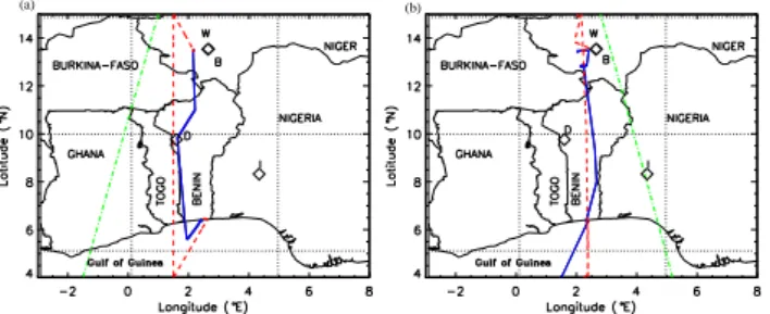
We also use observations of aerosol single scattering albedo (SSA) and asymmetry factor (g) at 441, 674, 869 and 1018 nm derived from sun-photometer measurements ac-quired within the framework of the Aerosol Robotic Network (AERONET). The SSA is defined as the ratio of the scatter-ing coefficient to the aerosol extinction coefficient (AEC). The parameter g is defined as the intensity-weighted average cosine of the scattering angle (the angle between incident light and scattering direction). The value of g ranges be-tween −1 for entirely backscattered light to +1 for entirely forward scattered light. The level 2.0 (cloud-screened) data from stations distributed over the Sahelian region, namely Banizoumbou (Niger; 13.54◦N, 2.66◦E), and the sub-Sahel, namely Djougou (Benin; 9.76◦N, 1.6◦E) and Ilorin (Nige-ria; 8.32◦N, 4.34◦E) are used (see Fig. 1). Given that the AODs are larger than 0.5 at 440 nm in the present case, the uncertainty on the SSA is on the order of 0.03 (Dubovik et al., 2000).
The irradiance measurements obtained from three ground-based stations deployed during AMMA, namely Wankama (Niger, 13.65◦N, 2.64◦E), Agoufou (Mali, 15.34◦N, 1.48◦E) and Nalohou (Benin, 9.73◦N, 1.60◦E) have been used for direct comparison with the irradiances derived from the radiative model (see Sect. 3 for details). Only com-parisons with the station of Wankama are presented in this paper. Downward and upward shortwave irradiances in Wankama were obtained from a Kipp and Zonen’s CM3
C. Lemaˆıtre et al.: Dust radiative heating rates over West Africa 8133
C. Lemaˆıtre et al.: Dust radiative heating rates over West Africa 17
(a) (b)
Fig. 1. SAFIRE F/F20 (red dashed line) and ATR-42 (solid blue line) flight on 13 June (a) and and 14 June (b) 2006. Overlain are the CALIPSO tracks (green dash-dotted lines) at 01:37 UTC on 13 June and 14:00 UTC on 14 June 2006. I, D, B and W correspond to the location of the Ilorin, Djougou, Banizoumbou AERONET stations and Wankama AMMA station, respectively.
Fig. 2. Aerosol scattering coefficient at 730 nm derived from LEANDRE 2 (between 0 and 180◦) at 700 m m.s.l. (red symbols) and aerosol scattering coefficient derivd from AVIRAD (between 90 and 180◦) at 700 nm (black solid line). LEANDRE 2 data are divided by a factor of 14 with respect to the AVIRAD data (see text for details).
Fig. 1. SAFIRE F/F20 (red dashed line) and ATR-42 (solid blue
line) flight on 13 June (a) and and 14 June (b) 2006. Overlain are the CALIPSO tracks (green dash-dotted lines) at 01:37 UTC on 13 June and 14:00 UTC on 14 June 2006. I, D, B and W correspond to the location of the Ilorin, Djougou, Banizoumbou AERONET stations and Wankama AMMA station, respectively.
ISO-class, thermopile pyranometer (spectral response: 0.3– 2.8 µm) while longwave irradiances were obtained from a CG3 pyronometer using a PT100 TRD sonde (spectral re-sponse: 5.0–50 µm).
2.2 Airborne data
During the AMMA SOP (Special Observing Period) 1a (June 2006, see Lebel et al., 2010), the Service des Avions Franc¸ais Instrument´es pour la Recherche en Environnement (SAFIRE) operated two research aircrafts, namely the Falcon 20 (F/F20) and the ATR 42. On 13 June 2006, the two aircraft flew for a coordinated north south land-atmosphere-ocean in-teraction mission over Benin, between Niamey (Niger) and Cotonou (Benin). In the afternoon of 14 June 2006, the two aircrafts flew between Cotonou and Niamey.
The aerosol vertical distribution together with the atmo-spheric dynamics and thermodynamics properties were doc-umented at the regional scale using the airborne lidar LE-ANDRE 2 (Bruneau et al., 2001; Flamant et al., 2007) and dropsonde measurements along the meridian transects per-formed at 1.5◦E on 13 June and between 2.15◦E and 2.5◦E on 14 June, spanning from 15◦N to 4◦N (Fig. 1). The F/F20 was flying at 8000 m above mean sea level (m.s.l.). Operations were conducted between 1130 and 13:30 UTC, and 13:00 and 15:00 UTC, on 13 and 14 June, respectively. Twelve dropsondes were released on 13 June and one on 14 June. Dropsonde data were processed with the Atmospheric Sounding Processing Environment software.
LEANDRE-derived AEC profiles (at 730 nm) were ob-tained from the total attenuated backscatter coefficient (TABC) profiles, via a standard lidar inversion technique (Fernald et al., 1972; Fernald , 1984), with a vertical res-olution of 15 m and a horizontal resres-olution of roughly 500 m. This inversion technique relies on the proportionality of the aerosol backscatter coefficient (ABC) and the AEC,
i.e. ABC(z) = BER × AEC(z), BER being the aerosol
backscatter-to-extinction ratio and z the altitude. We
con-sider that the BER is constant with altitude (e.g., Welton et al., 2000) and we use a value of 0.02 sr−1, which is a
climato-logical value for dust (Omar et al., 2009) interpolated lineary at 730 nm between values provided at 532 nm (0.024 sr−1) and 1064 nm (0.018 sr−1). The molecular backscatter coeffi-cient profiles used in the inversion procedure were obtained from dropsonde-derived pressure and temperature measure-ments. In the lidar inversion, multiple scattering effects may be considered by introducing a so-called multiple scattering factor η (0 ≤ η ≤ 1) to account for the reduction of the effec-tive aerosol extinction coefficient ηAEC(z) (e.g., Nicolas et al., 1997). In the case of dust particles, this effect can be ne-glected (η ≈ 1) for airborne lidar measurements (Ackermann et al., 1999), since the volume of air sampled by the lidar beam is sufficiently small (note that the laser footprint on the ground is ≈ 3.5 m wide). Because of the uncertainties on the value of the BER, the sensitivity of dust-related heating rates will be conducted thereafter (see Sect. 5).
Downward and upward shortwave irradiances at the alti-tude of the aircraft were obtained from an Eppley PSP pyra-nometer (spectral response: 0.285-2.8 µm) while downward and upward longwave irradiances were obtained from an Ep-pley PIR pyrgeometer (spectral response: 4-45 µm). These measurements will be for direct comparison with the surface albedo and the irradiances derived from the radiative model (see section 3 for details).
The dust aerosol optical and radiative properties, as well as their vertical distribution were documented in situ in the lower troposphere using the AVIRAD aerosol sampling sys-tem (Formenti et al., 2010). It consists in an isoaxial and isokinetic inlet whose 50% passing efficiency has been es-timated at 9 µm in diameter (Formenti et al., 2010). At the cruise speed of the ATR-42 (100 ms−1) the delivered flow
rate is 350 Lm−1. This allows connecting the inlet to mul-tiple instruments in parallel. Seven straight sampling lines depart from the inlet to provide: (i) straight-levelled run av-eraged measurements of the particle absorption coefficient at 370, 470, 520, 590, 660, 880 and 950 nm (aethalome-ter model AE31, Magee Sci.), (ii) high-temporal resolution (1 s) measurements of the particle scattering and backscat-tering coefficients at 450, 550 and 700 nm (nephelometer model 3596, TSI Inc.); (iii) number size distribution be-tween 0.3 and 20 µm in diameter (optical particle counter model 1.108, GRIMM), (iv) size-segregated aerosol compo-sition and mass concentration by impactor sampling (4-stage Dekati impactors) and (v) bulk aerosol composition and mass concentration by on-line filter sampling on Nuclepore mem-branes. The in situ scattering and absorption coefficients and the number size distribution were used to (i) evaluate the rele-vance of the aerosol model used in the STREAMER radiative code (aerosol single scattering albedo and asymmetry factor), and (ii) to validate the lidar extinction coefficient retrievals performed for both LEANDRE 2 and CALIOP. State-of-the-art correction factors were applied to the scattering, backscat-tering and absorption coefficient measurements (Anderson
8134 C. Lemaˆıtre et al.: Dust radiative heating rates over West Africa
C. Lemaˆıtre et al.: Dust radiative heating rates over West Africa 17
(a) (b)
Fig. 1. SAFIRE F/F20 (red dashed line) and ATR-42 (solid blue line) flight on 13 June (a) and and 14 June (b) 2006. Overlain are the CALIPSO tracks (green dash-dotted lines) at 01:37 UTC on 13 June and 14:00 UTC on 14 June 2006. I, D, B and W correspond to the location of the Ilorin, Djougou, Banizoumbou AERONET stations and Wankama AMMA station, respectively.
Fig. 2. Aerosol scattering coefficient at 730 nm derived from LEANDRE 2 (between 0 and 180◦) at 700 m m.s.l. (red symbols) and aerosol scattering coefficient derivd from AVIRAD (between 90 and 180◦) at 700 nm (black solid line). LEANDRE 2 data are divided by a factor of 14 with respect to the AVIRAD data (see text for details).
Fig. 2. Aerosol scattering coefficient at 730 nm derived from
LE-ANDRE 2 (between 0 and 180◦) at 700 m m.s.l. (red symbols) and aerosol scattering coefficient derivd from AVIRAD (between 90 and 180◦) at 700 nm (black solid line). LEANDRE 2 data are divided by a factor of 14 with respect to the AVIRAD data (see text for details).
and Ogren , 1998; Weingartner et al., 2003). Size correction of GRIMM data depends on the effective aerosol refractive index, and can result in important modifications in the posi-tion of the size bins, in particular when the aerosol is absorb-ing (Collins , 2000). However, when this is not determined in a robust way, the correction itself can induce important er-rors. Nonetheless, we have performed Mie calculations using the refractive index estimated by Voltz (1973) and Grams et al. (1974) (also see Sect. 3) at 780 nm (1.53–0.008i and 1.53– 0.0012i, respectively) to calculate the correction factor to be applied to the GRIMM nominal diameters. The correction factor is important, up to a factor of 2 for particles larger than 4.5 µm in diameter. As a consequence, the asymmetry pa-rameter g increases of 6% independently of the wavelength.
Only data collected during straight and leveled runs at con-stant altitudes above mean sea level were considered and north of 10◦N). In particular, the data used in this paper were collected whilst the aircraft was flying at 700 m.s.l., that is, very close to the ground. Over the two entire straight and leveled runs considered in this paper the air flow through the instrument was 11.3±0.4 Lmin−1(13 June) and 10.7±0.1 Lmin−1(14 June). This variability has been taken into account when estimating the errors affecting the mea-surements.
On 13 and 14 June, the ATR42 flew patterns at a constant altitude of 700 m.s.l. (see Fig. 1), i.e. in the monsoon layer for the most part. It also performed two soundings, on both days and at both ends of the flight track (i.e. in the vicinity of Niamey and Cotonou), in which case it sampled the dust layer originating from the Bod´el´e depression as well as West-ern Sudan and subsequently transported with the AEJ across West Africa and over Benin.
Figure 2 shows a comparison between the LEANDRE-derived scattering coefficient (at 730 nm) and the AVIRAD-derived scattering coefficient at 700 nm at an altitude of
700 m m.s.l. For the comparison, the lidar-derived scatter-ing coefficient is divided by a factor of 14 (the reason for this is explained below). The LEANDRE-derived scattering co-efficient (between 0 and 180◦) is computed as the product of the AEC by the SSA, after screening most cloudy pro-files. The SSA value used here is derived from the AVIRAD observations along the legs of interest. By construction, the AVIRAD scattering coefficient is obtained between 90 and 180◦. The ratio between the scattering coefficient between 0 and 180◦and the scattering coefficient between 90 and 180◦ was computed using Mie theory for spherical particles based on AVIRAD observations and two dust aerosol models (de-scribed at length in Sect. 3). This ratio was found to be equal to 12 in one case and 16 in the other case, thereby yielding a value of 14±2. Hence, the scattering coefficient derived from LEANDRE 2 is expected to be on the order of 14 times that derived from AVIRAD.
When modeling the aerosols as non spherical shapes rather than spherical particles, small differences were found be-tween the results from the Mie model with spherical particles and Mishchenko T-matrix code (Mishchenko et al., 1996) us-ing prolate and oblate particles uniformly distributed over all the possible aspect ratios centered around 1 (1% error on the SSA and the extinction coefficient). Mishchenko et al. (1996) suggested that this phenomenon can occur when large num-bers of randomly orientated particles in the sampling cham-ber are averaged, leading to a smaller error than for individ-ual particle counting. It may be also due to the uncertainties in our measurements, especially of size distribution, and the lack of knowledge on dust morphology.
As shown in Fig. 2, the scattering coefficient derived from AVIRAD and from LEANDRE (divided by 14) exhibit simi-lar fluctuations as a function of latitude, with a minimum be-tween 10.1 and 10.3◦N. Provided that a reduction by a factor of 14 is applied to the lidar data to account for the different observation geometry of the instruments, a very good agree-ment is found in terms of the scattering coefficient obtained with LEANDRE 2 and AVIRAD. This is an indication of the coherence between the two datasets.
2.3 Space-borne observations
2.3.1 Aerosol distribution
The regional distribution of dust aerosols was described us-ing three complementary satellite products. First, the Ozone Monitoring Instrument (OMI) daily Aerosol Index (AI) prod-uct was used. Second, aerosol optical depth (AOD) fields were obtained from the Moderate-resolution Imaging Spec-troradiometer (MODIS) AQUA collection 005 over vege-tated surfaces, and the MODIS/AQUA Deep Blue Collec-tion 005 over desert surfaces (MOD08 product). Third, the vertical distribution of the aerosols was documented using the space-borne lidar CALIOP (Winker et al., 2007) onboard the CALIPSO satellite. The three instruments are embarked
C. Lemaˆıtre et al.: Dust radiative heating rates over West Africa 8135 on platforms (namely AQUA, CALIPSO and AURA for
MODIS, CALIOP and OMI, respectively) that are part of what is now commonly referred to as the A-Train, and view the same scene within a few minutes. The A-train orbit over-passes West Africa twice a day, once during the daytime (be-tween 12:30 and 14:30 LST – local standard time) and once during the nighttime (between 00:30 and 02:30 LST), and has a revisit time period of the same orbit of 16 days (Stephens et al., 2002).
The lidar CALIOP provides vertical profiles of atmo-spheric reflectivity (at 532 nm and 1064 nm) allowing the re-trieval of the vertical distribution and the optical and radiative properties of aerosols and thin clouds. It has been previously used to study desert aerosols in the framework of AMMA program (e.g., Cuesta et al., 2008; Flamant et al., 2009; Kim et al., 2009). The CALIOP-derived reflectivity at 532 nm was analyzed along 2 overpasses (on 13 June around 01:39 UTC, 14 June around 13:20 UTC, see Fig. 1 for the position of the tracks).
We have computed CALIOP-derived AEC profiles (at 532 nm) using a standard inversion procedure as described in Sect. 2.2, and CALIOP TABC profiles (level 1B version 2 products) with a vertical resolution of 60 m and a horizon-tal resolution of roughly 12 km. The molecular backscatter coefficient profiles used in the inversion procedure were ob-tained from molecular density profiles extracted from the Na-tional Centers for Environmental predictions (NCEP) analy-ses along CALIPSO tracks. We use a constant BER profile with altitude yielding a value of 0.024 sr−1at 532 nm (Omar et al., 2009). Since the laser beam of CALIOP samples a rather large volume of air (the footprint at the ground is 90 m wide), we have to account for multiple scattering effects as-sociated with dust (η≤1). Following the Monte-Carlo sim-ulations of Young et al. (2008) and Berthier et al. (2006), we used a η profile increasing exponentially from 0.65 at the layer top, 0.87 below 500 m above ground level (a.g.l.) and to 0.95 at the ground, as in Cuesta et al. (2009) and Messager et al. (2010).
2.3.2 Cloud properties
The presence of clouds underneath an aerosol layer can sig-nificantly modify the heating rates due to aerosols. John-son (2003) has shown that presence of absorbing aerosol in stratocumulus-capped boundary layers led to large posi-tive semi-direct radiaposi-tive forcing, opposite in sign to the con-ventional direct forcing. For cumulus conditions, the semi-direct forcing was much smaller. Johnson et al. (2004) work on semi-direct effect of aerosol evidenced cooling at the top of the atmosphere whenever absorbing aerosol resided above the cloud layer. When aerosols were located at the same level as the cloud, Johnson et al. (2004) show that this resulted in a strong heating.
Hence, cloud properties are necessary to estimate the ef-fect of clouds. MODIS-derived cloud properties were also
used as input to the STREAMER radiative code in order to compute aerosol radiative heating rate above the shallow cu-mulus clouds commonly observed at the top of the monsoon layer over the southern half of Benin. The MODIS cloud product (MYD06 L2 collected from the AQUA platform) combines infrared and visible techniques to determine both physical and radiative cloud properties in the daytime as well as the nighttime. Daily global Level 2 data are used in this study, namely cloud phase (ice vs. water), effective droplet radius, and cloud optical thickness. These variables are avail-able at 1-km resolution. Cloud top temperature, height, ef-fective emissivity and phase as well as cloud fraction are also used and available at 5-km resolution. For the sake of homogeneity, 1-km resolution data were averaged to form 5×5 km2pixels.
2.3.3 Earth surface characterization
The radiative heating rate of aerosols depends on the reflec-tivity of the underlying surface as shown in Bierwirth et al. (2009). As the albedo can vary significantly along a given track (ranging from 0.2 near the Gulf of Guinea coast re-gion to almost 0.4 over parts of the Sahara), the evolution of the MODIS-derived albedo along the F/F20 and CALIPSO tracks was taken into account for the computation of the aerosol radiative heating rate profiles. In addition to the AOD and cloud properties related products, MODIS-derived sur-face albedo retrievals were also used in this study as input to the STREAMER radiative code. The MODIS albedo prod-ucts (MCD43C3) used in this paper are the directional hemi-spherical reflectance (black-sky albedo) and bihemihemi-spherical reflectance (white-sky albedo). The MCD43C3 product con-tains 16 days of data provided in a level-3 data set projected to a 0.05◦×0.05◦grid. Both Terra and Aqua data are used to obtain this product, providing the highest probability for quality input data. The average of the black-sky albedo and white-sky albedo is provided as an input to STREAMER. The standard deviation on the albedo corresponding to the area of interest is about 0.025.
Figure 3 shows a comparison of the MODIS surface albedo with the surface albedo determined from the airborne pyranometers onboard the F/F20 as the ratio of the upward to the downward shortwave irradiances on 14 June. A very good agreement between the two is observed north of 9.5◦N. South of 9.5◦N, the differences are related to the presence of cumulus type clouds at the top of the monsoon layer that can be observed in the airborne irradiances, while the MODIS albedo is derived from cloud-screened scenes. It is worth noting, that the albedo of cumulus clouds never exceeds 0.4, as inferred from the airborne measurements.
8136 C. Lemaˆıtre et al.: Dust radiative heating rates over West Africa
18 C. Lemaˆıtre et al.: Dust radiative heating rates over West Africa
Fig. 3. Surface shortwave albedo from MODIS (red line) derived along the F/F20 flight track on 14 June 2006. Superimposed are the total effective albedo (accounting for the surface, aerosol and clouds) obtained from shortwave downwelling and upwelling airborne irradiances (blue line) and from STREAMER-simulated irradiances (dark diamonds).
Fig. 3. Surface shortwave albedo from MODIS (red line) derived
along the F/F20 flight track on 14 June 2006. Superimposed are the total effective albedo (accounting for the surface, aerosol and clouds) obtained from shortwave downwelling and upwelling air-borne irradiances (blue line) and from STREAMER-simulated irra-diances (dark diamonds).
3 The radiative code
Vertical profiles of aerosol radiative heating rate over West Africa are quantied using the radiative transfer code STREAMER (Key and Scheiger , 1998; Key et al., 1998). STREAMER is a flexible code developed to compile radi-ances or irradiradi-ances for various atmospheric and surface con-ditions. Calculations are made using a 2 stream scheme with a discrete ordinate (DISORT) solver. Upward and downward irradiances (i.e. shortwave, longwave and net irradiances, see Eq. 1), cloud radiative effect (cloud forcing), and heating rates (HRs) can be computed over 24 shortwave bands (0.28 to 4 µm) and 105 longwave bands (4 to 400 µm).
The net irradiance can be written as:
Fz=Fdir,z↓ +Fdiff,z↓ −Fdiff,z↑ −Fem,z↑ (1)
where Fdir,z↓ is the direct downward irradiance, Fdiff,z↓ is the diffuse downward irradiance, Fdiff,z↑ is the diffuse upward ir-radiance, Fem,z↑ is the upward emitted irradiance and z is the altitude.
In the present study, the radiative forcing (i.e. heating or cooling) is calculated from a pair of STREAMER simula-tions, i.e. as the difference between a laden and a dust-free simulation (see Eq. 2). The total radiative forcing in the shortwave (longwave) part of the spectrum is computed as the integral of the forcing over the 24 (105) bands.
The radiative forcing is given by:
1F = Fd,z−Fo,z (2)
where Fd,zand Fo,zare the net irradiance in the presence of
dust and without dust, respectively.
Heating/cooling rates are computed for each layer, and are based on finite difference estimates of the irradiance diver-gence at each pair of levels (Eq. 3):
1T 1t = − g Cp 1F 1p (3)
where T is temperature (K), t is time (s), g is gravitational acceleration (ms−2), Cpis the specific heat of dry air (J K−1
kg−1), F is the net all-wave flux (W m−2), and p is the pres-sure (Pa). The gravitational acceleration is computed for each level from an empirical relationship derived for a stan-dard atmosphere. Computations are begun at the top of the atmosphere. Layer heating/cooling rates are converted to de-grees per day and are listed with the level that is their top. Therefore the surface level has a value of zero.
The aerosol optical properties (SSA, g and the AEC) can be user defined. These parameters (especially the SSA) are critical, and one should note that these parameters are very sensitive to the mineral composition of dust and size distri-bution (Sokolik and Toon , 1999) and need adjustment to re-trieve representative forcings (Balkanski et al., 2007). We have considered here two aerosol models in order to provide an estimate of the dispersion associated with the heating rate retrievals depending on the chosen aerosol model (see sec-tion 5.2). The models of SSA and g were selected for their overall agreement with the data available on this case (air-borne data and sun-photometers) in the visible. They are specified as a function of wavelength (Fig. 4).
The first dust model corresponds to the dust model pre-scribed in STREAMER, but modified following the study of Raut and Chazette (2008) in the visible part of the spec-trum (between 0.2 and 0.7 µm) to account for the ultra-violet-visible complex refractive index of dust particles observed in this part of Africa. This was determined from lidar mea-surements onboard an ultra light aircraft and the AERONET sunphotometer-derived size distributions gathered in Niamey during AMMA (January–February 2006). In this model, the SSA, the asymmetry parameter and the AEC between 0.7 and 40 µm are prescribed according to the aerosol complex re-fractive index published by Voltz (1973). This model is here on referred to as the RaCH model. The second model cho-sen is the more general Alfaro I model detailed in Chomette (1999) and Alfaro et al. (1998). Chomette (1999) derived the asymmetry parameter, SSA and AEC using a Mie model for spherical particles based on the refractive index of Voltz (1973) in the infrared (0.7 to 40 µm) and that of Grams et al. (1974) in the visible (0.2 to 0.7 µm). This model is referred to as the CHOM model in the following. Observations used in model RaCH have been made during the winter season, and aerosol properties may then be different from the ones observed in summer, as their origin may not be the same. The two selected models correspond to different composi-tions which are expected to induce a difference larger than the real one.
C. Lemaˆıtre et al.: Dust radiative heating rates over West Africa 8137
C. Lemaˆıtre et al.: Dust radiative heating rates over West Africa 19
(a) (b)
(c) (d)
(e) (f)
Fig. 4. Aerosol optical properties from the RaCH model (black solid line) and CHOM model (black dashed line) as a function of wave-length: single scattering albedo (a), asymetric factor (c), extinction coefficient normalized at 550 nm (e) and refractive index (f) used for STREAMER. The red and green symbols correspond to the measurements made by the AVIRAD aerosol sampling device during the 13 and 14 June 2006 ATR-42 flights. AERONET retrievals are in purple (Ilorin), light blue (Djougou) and dark blue (Banizoumbou). (b) as in (a) but zoomed between 0.2 and 2µm. (d) as in (c) but zoomed between 0.2 and 2 µm.
Fig. 4. Aerosol optical properties from the RaCH model (black
solid line) and CHOM model (black dashed line) as a function of wavelength: single scattering albedo (a), asymetric factor (c), ex-tinction coefficient normalized at 550 nm (e) and refractive index
(f) used for STREAMER. The red and green symbols correspond
to the measurements made by the AVIRAD aerosol sampling de-vice during the 13 and 14 June 2006 ATR-42 flights. AERONET retrievals are in purple (Ilorin), light blue (Djougou) and dark blue (Banizoumbou). (b) as in (a) but zoomed between 0.2 and 2 µm. (d) as in (c) but zoomed between 0.2 and 2 µm.
The single scattering albedo from the CHOM is seen to be greater (lower) with respect to the RaCH model at wave-length greater (lower) than 0.7 µm (Fig. 4a, b). From Fig. 4b it is obvious that sun-photometer data are in better agree-ment with the RaCH model (resp. the CHOM model) for wavelength shorter (resp. larger) than 0.7 µm, thereby in-dicating the weakly absorbing nature of the dust aerosols sampled over the AERONET sites in Niger, Benin and Nige-ria. The columnar SSAs derived from AERONET are rang-ing from 0.91 at 441 nm to 0.98 at 1018 nm. The AVIRAD derived SSA values exhibit more dispersion than their sun-photometer counterparts, especially on 14 June 2006. On 13 June, airborne SSA values are around 0.83, evidencing the presence of weakly absorbing aerosols. On 14 June, SSA values are greater and exhibit a larger dispersion than on 13 June. It is worth noting that AVIRAD-derived SSA values are consistently showing better agreement with the model exhibiting the largest SSA. In conclusion, it appears that the aerosols in RaCH are likely too absorbing across the visible spectrum. Likewise, the aerosols in CHOM are too absorbing
below 0.8 µm and are in good agreement with observations between 0.8 and 1.1 µm.
The asymmetry factor from the two models is found in broad agreement between 1 and 2 µm, while it is seen to be underestimated in the RaCH model with respect to the CHOM model for the remaining part of the spectrum con-sidered here (Fig. 4c, d). Between 0.3 and 1 µm, the sun-photometer derived asymmetry factor values are between the curves associated with the two models (Fig. 4d). Two se-ries of asymmetry factor values were obtained from the AVI-RAD data, based on the refractive index of the two models at 780 µm (see Sect. 2). AVIRAD-derived observations are found in good agreement with the asymmetry factor of both models. Little difference was observed between asymmetry factor values on 13 and 14 June, for a given model. They range between 0.72 and 0.82, in agreement with the values of Saha et al. (2008) and Raut and Chazette (2008).
Figure 4e shows the spectral evolution of the modeled AEC (normalized at 550 nm), together with the AVIRAD measurements available in the visible. The normalized AEC in the RaCH model is underestimated (overestimated) with respect to the CHOM model for wavelengths larger (smaller) than 550 nm. AVIRAD data are in broad agreement with the modeled AEC. Finally, the real refractive indices used in RaCH and CHOM are very similar but imaginary parts are not, reflecting SSA differences (Fig. 4f).
Gaseous absorption by water vapour, carbon dioxide, ozone, and oxygen is computed following Tsay et al. (1989). The model runs with an emissivity of 0.90 for desert surfaces (Ogawa et al., 2004) and of 0.85 for the oceanic surfaces. The spectral reflectance is taken according to Tanre et al. (1986) for desert and from Briegleb et al. (1986) for oceanic sur-faces. Profiles of atmospheric temperature, water vapor, and pressure need to be prescribed as inputs to the STREAMER simulations.
For the surface albedo a built-in spectral albedo model pre-scribed in STREAMER is used, but it is scaled by a user-specified visible albedo determined using MODIS data for the surface types present. The surface albedo models avail-able in SREAMER are based on either modeled or observed data in the literature. Sand data are from Tanre et al. (1986). Spectral albedos for grass, dry grass and deciduous forest were taken from the ASTER Spectral Library v1.0 CD (Cal-ifornia Institute of Technology, 1988).
4 The 13–14 June 2006 case study
4.1 Synoptic conditions during the dust event
During the 9–12 June period, i.e. 2–4 days before the air-borne observations over Benin, strong northeasterly Harmat-tan winds were seen in the European Centre for Medium-range Weather Forecast (ECMWF) analyses over the Niger-Chad-Sudan sector of the Sahara (not shown). These winds
8138 C. Lemaˆıtre et al.: Dust radiative heating rates over West Africa were the primary driver of dust emission in this sector, known
to hold some of the most productive dust sources in West Africa, notably the Bod´el´e depression (in Chad) and the Su-danese sources in the May–July period. The ECMWF anal-yses at 925 hPa show strong winds, in the form of a north-easterly low-level jet, to the east of West Sudan at 00:00 UTC during the 9–13 June period (Flamant et al., 2009). Similarly, strong north-easterly low level winds were also observed be-tween the Tibesti and Ennedi mountains in Chad, and over the Bod´el´e depression at 00:00 UTC. It is now well estab-lished that dust emission from the Bodele (and also over Su-dan in this case) are related to the downward transfer of mo-mentum from the nocturnal low-level jet to the surface due to turbulent mixing after solar heating commences each day (Todd et al., 2008).
The transport patterns of dust from eastern Saharan sources towards the southwest in this case have been de-scribed by Flamant et al. (2009). In particular, they have highlighted the role of the inter-tropical discontinuity and the Darfur Mountains in injecting the aerosols from Bod´el´e and Sudan, respectively, over the monsoon flow, and in the AEJ region.
4.2 Regional distribution of aerosol from 9 to 13 June
2006
The temporal evolution of the dust load over the Bod´el´e re-gion and over Sudan has been investigated by Flamant et al. (2009) using daily MODIS Deep Blue AODs between 9 June and 15 June 2006. They show that over the Bod´el´e region, the dust load exhibited a decrease from 2.6 to 0.65 between 9 and 13 June, while over Sudan the dust load increased between 9 and 12 June (from 0.70 to 1.1), and decreased afterward. As noted by Flamant et al. (2009), the aerosol load appears to be advected westward between 9 and 14 June (not shown).
Figure 5a shows the regional distribution of AOD on 13 June. The dust transport from the Eastern dust sources across West Africa with the AEJ is seen in the form of an elon-gated band of high AOD values (>1 at 550 nm) extending from Sudan to Senegal between roughly 5◦N and 18◦N. The dust load over Benin on 14 June (0.5–1.2) was observed to be smaller than on 13 June (1.5–1.6) (Fig. 5b). This is in agreement with Flamant et al. (2009) who have shown that in Djougou, AERONET-derived AOD values at 440 nm (675 nm) decreased from 1.12 (1.06) at midday on 13 June to 0.72 (0.66) at midday on 14 June.
4.3 Vertical distribution of dust over Benin on 13 and
14 June
The two-dimension cross-sections of TABC (AEC) retrieved from LEANDRE 2 along the F/F20 flight track on 13 June and 14 June are shown in Fig. 6a and c (Fig. 6b and d), re-spectively.
20 C. Lemaˆıtre et al.: Dust radiative heating rates over West Africa
(a) (b)
Fig. 5. MODIS-derived AOD at 670 nm over West Africa from 13 June (a) to 14 June (b) 2006 with CALIPSO tracks (black line).
(a) (b)
(c) (d)
(e)
Fig. 6. LEANDRE-derived total attenuated backscatter coefficient (TABC) and LEANDRE-derived aerosol extinction (AEC) on 13 June (a and b, respectively) and 14 June (c and d, respectively). Clouds appear as areas with high TABC (white) above regions characterized by reduced TABC (blanks in AEC) as a result of attenuation between the cloud top and ground. (e) Aerosol optical depth from LEANDRE 2 at 730 nm (diamonds) and MODIS at 670 nm (solid red line).
Fig. 5. MODIS-derived AOD at 670 nm over West Africa from 13
June (a) to 14 June (b) 2006 with CALIPSO tracks (black line).
On 13 June, LEANDRE 2 measurements evidenced the presence of an extended and thick dust plume spanning from north of Niamey (15◦N) to the Benin coastline (6◦N) (Fig. 6b). The depth of the plume was of the order of 3 km, while the height of the top of the plume was observed to in-crease with latitude. In connection with the presence of the monsoon flow, smaller reflectivity values were observed be-low the dust plume along the entire transect, because of the much lower aerosol content to which the lidar is sensitive. South of 11◦N, over the continent, cumulus clouds were ob-served below the dust plume which marked the top of the monsoon layer. They are characterized by large AEC val-ues, in excess of 0.5 km−1In some instances, these clouds were observed to penetrate the dust plume (e.g. between 8◦ and 9◦N). The dust plume over Benin and Niger is charac-terized by values in excess of 0.15 km−1. Values larger than 0.4 km−1are also seen in the vicinity of Niamey (from 12.5 to 15◦N), between 2.5 and 3.5 km m.s.l.
On 14 June, north of 6.5◦N, the LEANDRE 2-derived AEC along the transect exhibits lower values than on the previous day above the monsoon flow (Fig. 6d). The largest AEC values on this day are on the order of 0.15 km−1. The
latitudinal structure of the altitude of the plume top on 14 June was very similar to that observed on 13 June. How-ever, it was observed to extent further south. Also, north of 10◦N, the AEC was observed to exhibit much less vertical variability. Numerous cumulus clouds were also observed at the top of the monsoon layer over the southern part of the transect. As pointed out by Flamant et al. (2009), the reduc-tion of the dust load between 13 and 14 June is essentially re-lated to the fluctuations of the dust emissions over the source regions 2 to 4 days prior to the airborne measurements over Niger and Benin. The comparison between the LEANDRE-derived AODs (obtained after integration of the AEC in the dust plume using a BER of 0.20 sr−1) and the MODIS AODs
at 670 nm along the F/F20 track the 14 June 2006, without clouds, is shown in Fig. 5e. MODIS AODs are consistent with lidar AODs in the plume. It is observed that the latitudi-nal trend in MODIS AODs is more marked to the South. The lower lidar AODs are partly explained by the larger wave-length.
C. Lemaˆıtre et al.: Dust radiative heating rates over West Africa 8139 20 C. Lemaˆıtre et al.: Dust radiative heating rates over West Africa
(a) (b)
Fig. 5. MODIS-derived AOD at 670 nm over West Africa from 13 June (a) to 14 June (b) 2006 with CALIPSO tracks (black line).
(a) (b)
(c) (d)
(e)
Fig. 6. LEANDRE-derived total attenuated backscatter coefficient (TABC) and LEANDRE-derived aerosol extinction (AEC) on 13 June (a
and b, respectively) and 14 June (c and d, respectively). Clouds appear as areas with high TABC (white) above regions characterized by reduced TABC (blanks in AEC) as a result of attenuation between the cloud top and ground. (e) Aerosol optical depth from LEANDRE 2 at 730 nm (diamonds) and MODIS at 670 nm (solid red line).
5 Radiative impact
A series of STREAMER simulations were performed on 13 and 14 June 2006, to quantify radiative forcing profiles of dust aerosols according to the latitude (between 6◦N to 15◦N) between the vegetated coast and the dry Sahel. HRs were computed indifferently in cloud-free conditions and in the presence of low-level clouds, in spite of the fact that STREAMER might not be able to account for three-dimensional effects induced by clouds. This choice was mo-tivated by the fact that the liquid water content associated with the cumulus clouds was rather small (on the order of 0.05 gm−3, see below) and that the albedo associated with
these clouds is comprised between 0.2 and 0.4 (Fig. 3). Ul-timately, the relevance of this approach was assessed by the fact that, at a given altitude, coherent HRs were obtained for contiguous profiles, independently of the presence of cumu-lus type clouds.
First, STREAMER simulations are performed for each air-borne and space-air-borne lidar-derived AEC profile to infer the radiative forcing (i.e. heating or cooling) associated with the dust-laden atmosphere. In addition to the lidar-derived AEC profiles, profiles of temperature, pressure and water vapour mixing ratio as well as surface albedo have to be provided. MODIS-derived surface albedo (0.05◦ resolution) was lin-early interpolated along the F/F20 and CALIPSO tracks so that one albedo value is associated with a given AEC. In the
case of the presence of a low-level clouds, such as the cu-mulus clouds seen in the lidar observations at the top of the monsoon layer (Fig. 6), the radiative forcing is computed at the level of the cloud layer and above the cloud top height, accounting for the cloud properties as derived from MODIS (see Sect. 2.3.2). We have used average cloud properties as representative of cumuli over southern Benin. The follow-ing MODIS-derived values have been used as characteristic of the cloud properties in the region of interest: the cloud optical thickness in the visible is taken as 7.25 (±6.63), the cloud particle effective radius is set to 7.74 (±3.80) µm and the liquid water concentration is equal to 0.051 (±0.045) gm−3. We only consider low-level liquid-water clouds (high-level or even mid-(high-level clouds being almost always above the aerosol plume). The cloud top temperature is determined from the MODIS-derived cloud top pressure and a prescribed temperature profile. The cloud thickness is computed in STREAMER using the values of optical thickness, effective radius and water concentration. In the case of elevated clouds such as towering cumuli reaching the top of the aerosol layer (see for instance at 13.3◦N in Fig. 6a and b) the profile is discarded altogether. There are very few such cases in the LEANDRE 2 data. Similarly, elevated clouds (such as cir-rus clouds) associated with nearby convective systems were often observed with CALIPSO. In the cases also, the con-taminated profiles are discarded altogether. Finally, the pro-files of temperature, pressure and water vapour mixing ratio
8140 C. Lemaˆıtre et al.: Dust radiative heating rates over West Africa
C. Lemaˆıtre et al.: Dust radiative heating rates over West Africa 21
(a) (b)
(c) (d)
Fig. 7. LEANDRE-derived AEC profiles at 10◦N (a) in cloud-free conditions and 5◦N (c) in cloudy conditions, and corresponding heating rate (HR) (b,d) for the 14 June. Dashed line in (c) corresponds to location of the cloud top as derived from LEANDRE 2 measurements.
(a) (b)
(c) (d)
Fig. 8. Comparison between irradiances profiles derived from STREAMER (black solid line) obtained at the location of the Wankama station and at the time of the F/F20 overpass on 14 June. The data from the F/F20 are in red and data from the Wankama station are in green: upward shortwave (a) downward shortwave (b), upward longwave (c) and downward longwave (d).
Fig. 7. LEANDRE-derived AEC profiles at 10◦N (a) in cloud-free conditions and 5◦N (c) in cloudy conditions, and corresponding heating rate (HR) (b, d) for the 14 June. Dashed line in (c) corre-sponds to location of the cloud top as derived from LEANDRE 2 measurements.
profiles needed to compute the radiative forcing from the CALIOP data are from NCEP analyses and are provided for each CALIOP profile. On the other hand, we have used drop-sonde measurements to characterize the lower troposphere and compute the radiative forcing. STREAMER simulations on 13 June are performed using average temperature, pres-sure and water vapour mixing ratio profiles computed from the profiles obtained from the 13 dropsondes released on that day. STREAMER simulations on 14 June are performed us-ing the temperature, pressure and water vapour mixus-ing ratio profiles obtained from the single dropsonde released on that day. As discussed in the next section, radiative forcing in these cases was only marginally sensitive to the temperature, pressure and water vapour mixing ratio profiles.
Figure 7 shows an example of an AEC retrieved from the LEANDRE 2 measurements in cloud-free conditions over Benin at 10◦N (Fig. 7a) and the corresponding vertical
pro-file of radiative heating obtained from STREAMER using the RaCH model and CHOM model (Fig. 7b). In this ex-ample, the dust layer traveling the AEJ region is essentially comprised between 1.8 and 4.8 km a.g.l. Below, the AEC decreases and is minimum around 1 km a.g.l., and increases in the monsoon layer. Furthermore, the examination of the spectral dependence of the in situ measured scattering co-efficient show that mineral dust was indeed dominant north of 10◦N. Figure 7 also shows an example of an AEC pro-file retrieved from LEANDRE 2 in the presence of low-level clouds over the Gulf of Guinea at 5◦N (Fig. 7c) and the corresponding vertical profile of radiative heating ob-tained from STREAMER using the RaCH model and CHOM model (Fig. 7d). In the present case the altitude of cloud is 2.3 km m.s.l..
C. Lemaˆıtre et al.: Dust radiative heating rates over West Africa 21
(a) (b)
(c) (d)
Fig. 7. LEANDRE-derived AEC profiles at 10◦N (a) in cloud-free conditions and 5◦N (c) in cloudy conditions, and corresponding heating rate (HR) (b,d) for the 14 June. Dashed line in (c) corresponds to location of the cloud top as derived from LEANDRE 2 measurements.
(a) (b)
(c) (d)
Fig. 8. Comparison between irradiances profiles derived from STREAMER (black solid line) obtained at the location of the Wankama station and at the time of the F/F20 overpass on 14 June. The data from the F/F20 are in red and data from the Wankama station are in green: upward shortwave (a) downward shortwave (b), upward longwave (c) and downward longwave (d).
Fig. 8. Comparison between irradiances profiles derived from STREAMER (black solid line) obtained at the location of the Wankama station and at the time of the F/F20 overpass on 14 June. The data from the F/F20 are in red and data from the Wankama sta-tion are in green: upward shortwave (a) downward shortwave (b), upward longwave (c) and downward longwave (d).
The AEC profile shown in Fig. 7a was obtained using a BER of 0.02 sr−1, and the heating rate profiles (Fig. 7b) were obtained using a visible surface albedo of 0.20, a tempera-ture profile derived from the dropsonde released on 13 June at 10◦N, a mean ozone column of 320 Dobson, and over a vegetated surface. This profile is referred to as the reference profile in the following. The maximum heating rate of about 2.3 Kday−1is obtained at the altitude where the dust plume
exhibits the largest AEC values (i.e 3 km m.s.l.) for RaCH model and about 3 Kday−1with CHOM model. Satheesh et
al. (2002) evidenced a dust-related heating rate between 0.4 and 1.2 Kday−1over northern Africa (10–20◦N; 20–30◦E) and southern Africa (10–20◦S; 20–30◦E) using direct ob-servation of solar radiation in the shortwave part of the spec-trum. From Fig. 7a and b, it is quite obvious that the heating rate increases as AEC increases, even in the monsoon layer.
The AEC profile shown in Fig. 7c was obtained using a BER of 0.02 sr−1, and the heating rate profiles (Fig. 7d) were obtained using a cloud optical thickness in the visible of 7.25, a cloud physical thickness of 45 m, a cloud parti-cle effective radius of 7.74 µm, a liquid water concentration equal to 0.051 gm−3, a temperature profile derived from the
dropsonde released on 13 June at 10◦N, and a mean ozone
column of 320 Dobson. This profile is referred to as the ref-erence profile in cloudy conditions in the following. In these conditions, the heating rate just above the cloud layer can reach 4.3 Kday−1 (RaCH model) and 4.8 Kday−1 (CHOM model) for an AEC of 0.08 km−1, while lower heating val-ues are obtained in cloud-free conditions at higher altitude where the AEC reaches 0.17 km−1(2.8 and 3.2 Kday−1for the RaCH and CHOM models, respectively). This is found in agreement with the large-eddy model based results of John-son et al. (2004) who evidenced the strongest heating rates to be located in the vicinity of clouds. In the case, nonlinear ef-fects are evident in the immediate vicinity of the clouds, and the strongest heating rates are obtained for significant but yet moderate AEC values.
C. Lemaˆıtre et al.: Dust radiative heating rates over West Africa 8141
5.1 Comparison of irradiances and surface/cloud
albedo from the model with measurements
To assess the performance of STREAMER, a comparison was made between irradiances obtained at the location of the Wankama station and at the time of the F/F20 overpass on 14 June. The upward and downward shortwave and long-wave irradiances profiles obtained from the LEANDRE 2 data using STREAMER are compared to near surface irra-diance values (Wankama station) and irrairra-diance values at the altitude of the F/F20 (Fig. 8). The instruments have simi-lar spectral responses as described in Sect. 2, which are also close to longwave and shortwave spectral intervals defined in STREAMER (see Sect. 3). The comparison was con-ducted for diffuse upward shortwave irradiances (Fig. 8a), to-tal downward shortwave irradiances (Fig. 8b), upward long-wave irradiances (Fig. 8c) and downward longlong-wave irradi-ances (Fig. 8d).
In the shortwave spectrum, a good agreement is seen be-tween simulations and observations, exception made of the near surface total shortwave irradiance (Fig. 8b). In the long-wave spectrum, the agreement between the STREAMER simulations and the observations are not as good, exception made of the near surface upward irradiances (Fig. 8d).
The surface/cloud albedo computed with STREAMER from each LEANDRE 2 profiles along the F/F20 track on 14 June is shown in Fig. 3. In cloud-free conditions, good agreement is found with MODIS surface albedo, as expected, since STREAMER uses a built-in albedo model scaled to MODIS visible albedo. Good agreement is also found with the albedo derived from airborne measurements. In the pres-ence of cumulus type clouds, good agreement is found be-tween STREAMER simulations and the albedo derived from airborne measurements, particularly between 6 and 9.5◦N (i.e. over land).
5.2 Sensitivity studies
In this section we conduct a series of sensitivity studies to (i) the surface albedo, (ii) type of soil (vegetated or rather dry), (iii) aerosol backscatter-to-extinction ratio, (iv) ozone con-tent, (iv) temperature and water vapor mixing ratio profiles, as well as (v) cloud microphysical, optical and structural properties, in order to evaluate the potential sources of uncer-tainties in the radiative forcing results presented above. The sensitivity analyses are conducted using the AEC profiles shown in Fig. 7a (cloud-free conditions) and Fig. 7c (low-level cloud conditions), and for the RaCH aerosol model. The sensitivity is also quantified in terms of uncertainty pro-files (in Kday−1), which are computed as the difference be-tween the reference profile (shown in Fig. 7b and d) and sen-sitivity profile.
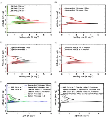
Fig. 9. Sensitivity of the LEANDRE-derived heating rate profile at
10◦N on 14 June to: (a) surface albedo (b) type of soil, (c) dust BER and (d) lidar AEC. Uncertainties (in Kday−1) for each of the previous variables are shown in (e). Uncertainties are computed with respect to reference profile shown in Fig. 7a and using the RaCH model. The total uncertainty on the HR, taken as the sum of the quadratic errors of all variable previously shown are shown in (f): the dashed line corresponds to the minimum total uncertainty and the solid line corresponds to the maximum total uncertainty (see text for details).
5.2.1 Cloud-free conditions
The first sensitivity test was conducted on surface albedo. The MODIS albedo error is estimated to be on the order 0.03 (Roman et al., 2010). As shown by Fig. 3, a maxi-mum albedo variability of 0.05 is observed per 0.5◦in lat-itude. So three values of surface albedo have been used to test the sensitivity of HRs to albedo: 0.20 (reference pro-file), 0.15 and 0.25. While changing the albedo from 0.15 to 0.25 (all other variables remaining constant), the HR pro-file is only slightly modified and is shifted towards higher values as albedo increases (Fig. 9a). A surface albedo in-crease means that more radiation is reflected by the surface. The outgoing radiation leaving the surface also interacts with dust layer which increases the overall absorption. This result is in agreement with Heintzenberg et al. (1997), Satheesh et al. (2002) or Raut and Chazette (2008). As a result, an er-ror of 20% (0.20±0.05) on the albedo leads to an erer-ror of 0.2 Kday−1 on the HR in the part of the plume exhibiting the largest AEC (and smaller elsewhere) and an error in the monsoon layer less than about 0.1 Kday−1(Fig. 9e).
8142 C. Lemaˆıtre et al.: Dust radiative heating rates over West Africa The sensitivity of the heating rate retrievals to the type of
surface was also investigated by performing a STREAMER simulation with the surface characterized as vegetation and another with a soil characterized as dry (all other variables being identical). The radiative impact of dust is strongest above vegetated (darker) surfaces (Fig. 9b) consistently with the change in albedo discussed previously. The difference between the surface type leads an error on the order of 0.2 Kday−1 on the heating rate profile in the aerosol layer and a slightly smaller error in the monsoon layer (Fig. 9e).
Profiles issued from dropsondes released on 13 June every 2◦along the Niamey-Cotonou transect were used to compute the heating rates at 10◦N on 14 June. The sensitivity of the heating rate retrievals to the temperature, pressure and water vapor mixing ratio profiles were found to be negligible, ex-cept below the dust layer where it is very small between 0 and 0.2 Kday−1(not shown).
Concerning ozone, HR profiles were found not to be sen-sitive to the total column (not shown). The sensitivity was tested for a value of 280 Dobson.
We also have tested the sensitivity of the HR profiles to the BER value. As stated in Sect. 2.2, a value of 0.02 sr−1was selected for the inversion of the LEANDRE 2 data, while a value of 0.024 sr−1(modulated by a factor accounting for multiple scattering and ranging between 0.95 and 0.65) was chosen for the inversion of the CALIOP data (Sect. 2.3.1). Recent studies evidenced that that BER variations associated with dust in this region of the globe are generally less than 20% (Wandinger et al. (2010), Omar et al. (2009)). Hence, we have analyzed the sensitivity of the LEANDRE 2-derived HR to an error of ±0.004 sr−1 on the BER values, i.e. for
BER values ranging from 0.016 to 0.024 sr−1. An increase
of the BER leads to a decrease of HR values throughout the profile (Fig. 7c). The error resulting from uncertainties on the BER can be as high as 1.7 Kday−1in the optically thick-est part of the dust plume, in agreement with the results of Berthier et al. (2006). The error in the monsoon layer, i.e. below the dust plumes (≈1 Kday−1), are found to be larger than those in the upper, optically less thick, part of the plume (≈0.6 Kday−1).
Finally, the error on the dust HR associated with an un-certainty of 10% on the aerosol extinction coefficient profile retrieved from lidar measurements was taken into account. Dust HR increases with AEC as shown by Fig. 9d. The max-imum error is located in dust layer and is on the order of 0.25 Kday−1.
Figure 9e shows the expected uncertainties on the HR pro-file associated with the error sources identified above. The largest uncertainties (or 1HR) are related to errors on the BER, all other variables remaining equal. The same uncer-tainty is found on the HR whether a +10% or a -10% error is considered for the extinction. The same is true also when one considered an albedo of 0.15 or 0.25.
The total uncertainty on the HR values, taken as the sum of the quadratic errors related to the type of soil, the albedo,
the BER and the extinction, can be written as:
σ1HR= [(HRalb0.15−HRalb0.20)2+(HRdry−HRvegeted)2 +(HRBER0.020±0.004 − HRBER0.020)2
+(HRext10−HRext)2]1/2
In all cases, the total uncertainty is computed with respect to the reference profile. Because the uncertainty is mainly sen-sitive to the BER value, two profiles are shown in Fig. 9f : a profile corresponding to the minimum total uncertainty and a profile corresponding to the maximum total uncertainty. Fig-ure 9f evidences that the uncertainty in the thickest part of the plume was between 0.6 and 1.3 Kday−1, and less than that in the upper part of the plume. These values were also found to be representative of the average total uncertainties com-puted along the entire F/F20 transect while only considering cloud-free lidar profiles.
5.2.2 Cloudy conditions
We have tested the sensitivity of the HR profiles to the BER values, as in the previous section. As observed for the cloud-free profiles, increased BER values lead to decreased heating rate values throughout the profile (Fig. 10a). Resulting un-certainties are comprised between 0.5 and 1.1 Kday−1in the optically thickest part of the dust plume (Fig. 10e). As in cloud-free condition, HR profiles were found not to be sensi-tive to the total column values prescribed in STEAMER (not shown).
The sensitivity of HR profiles to the cloud radiative, optical and structural properties were then tested for: (i) cloud physical thickness (Fig. 10b), (ii) cloud optical depth (Fig. 10c), and (iii) cloud particle effective radius (Fig. 10d). Heating rates profiles were found to be insensitive to water concentration (not shown). Sensitivity tests were made based on the standard deviation of the MODIS-derived clouds prop-erties.
The influence of the cloud physical thickness on the heat-ing rate profiles is mainly located in the immediate vicin-ity of the cloud layer (Fig. 10b, e). The maximum of HR in the cloud is found to be stronger for the shallower cloud (i.e. 10 m). The maximum is found to be located higher be-cause the reference of physical thickness is at the top of the cloud. The error relative to the reference value (45 m) is null in most of the aerosol layer (Fig. 10e) and is more important in the lower part of the plume, in the cloud layer. Large un-certainties on the HR are obtained for very shallow clouds (3.6 Kday−1).
The sensitivity of the HR profiles to the cloud optical thickness values is analyzed next for extreme values rang-ing from 1 to 14.95 (Fig. 10c). An increase of the optical thickness leads to an increase of heating rate values through-out the profile. Important errors are also found at the bottom of the dust layer, in the vicinity of the cloud top. They are smaller for optically thicker clouds (0.2 Kday−1for an opti-cal depth of 14.95 versus 2 Kday−1for an optical depth of
C. Lemaˆıtre et al.: Dust radiative heating rates over West Africa 8143
C. Lemaˆıtre et al.: Dust radiative heating rates over West Africa 23
(a) (b)
(c) (d)
(e) (f)
Fig. 10. Sensitivity of the LEANDRE-derived heating rate profile at 5◦N on 14 June to: (a) dust BER, (b) cloud geometrical depth, (c) cloud optical thickness and (d) effective radius of cloud particles. Uncertainties (inKday−1) for each of the previous variables are shown in
(e). Uncertainties are computed with respect to reference profile shown in Fig. 7c and using the RaCH model. The total uncertainty on the HR, taken as the sum of the quadratic errors of all variable previously shown are shown in (f): the dashed line corresponds to the minimum total uncertainty and the solid line corresponds to the maximum total uncertainty (see text for details).
Fig. 10. Sensitivity of the LEANDRE-derived heating rate profile
at 5◦N on 14 June to: (a) dust BER, (b) cloud geometrical depth,
(c) cloud optical thickness and (d) effective radius of cloud
parti-cles. Uncertainties (in Kday−1) for each of the previous variables are shown in (e). Uncertainties are computed with respect to ref-erence profile shown in Fig. 7c and using the RaCH model. The total uncertainty on the HR, taken as the sum of the quadratic er-rors of all variable previously shown are shown in (f): the dashed line corresponds to the minimum total uncertainty and the solid line corresponds to the maximum total uncertainty (see text for details).
1). In the core of the dust plume, the maximum uncertainties are on the order of 0.9 Kday−1for optically thick clouds and
0.6 Kday−1for optically thin clouds.
Finally, the sensitivity of the heating rate retrievals to the cloud particle effective radius was found to be quite small (Fig. 10d). The largest uncertainties are found at the bottom of the dust layer, in the vicinity of the cloud top (0.2 Kday−1). Uncertainties are smaller for smaller effective radius. In the core of the dust plume, the maximum uncer-tainties are on the order of 0.1 Kday−1.
The total uncertainty on the HR values, taken as the sum of the quadratic errors related the variables described above, was also computed in the case of cloudy profiles (Fig. 10f). The largest total uncertainties in the dust plume are associ-ated with a BER of 0.016 sr−1, a cloud particle effective ra-dius of 3.74, a cloud physical thickness of 10 m and an cloud optical thickness of 1. The smallest uncertainty is obtained a BER of 0.024 sr−1, a cloud particle effective radius of 14.9, a cloud physical thickness of 100 m and an cloud optical thick-ness of 14.9. Figure 10f evidences that the uncertainty in the thickest part of the plume was between 0.8 and 1.3 Kday−1,
and less than that in the upper part of the plume. The largest uncertainties are associated with HR retrievals just above the cloud layer (between 1 and 4.3 Kday−1). These values were
also found to be representative of the average total uncer-tainties computed along the entire F/F20 transect while only considering cloudy lidar profile.
We have to bear in mind that a cooling effect at the level of the cloud is observed for a reference case, without aerosols. The previous results highlight that a dust aerosol layer over-lying a cloud reduces the cloud cooling effect mentioned above. This is due to an attenuation thought the dust layer of the radiative irradiances reaching the cloud. In comparison to the reference case the resulting effect is a local warming of the atmosphere at the cloud location.
5.3 Daytime observations
5.3.1 Radiative impact from LEANDRE 2 data
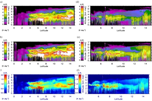
Figure 11a and 11b show the heating rates HRs associated with dust on 13 June computed using the RaCH and CHOM models, respectively, and the AEC shown in Fig. 6b. Fig-ure 11d and e represent the HR associated with dust on 14 June 2006 computed using the RaCH and CHOM models, respectively, and the AEC shown in Fig. 6d.
Maximum values of the heating rates are observed at the location of maximum dust-related AEC. They are mainly due to the shortwave contributions (for more than 60%). Two regions of particularly high heating rates (in excess of 6 Kday−1, reaching 8 Kday−1in some instances, see Fig. 11) are seen between 6◦N and 10◦N (above the cumulus clouds
over vegetated Benin) and between 12◦and 15◦N (over the
drier Sahel). A weak but non negligible HR (on the order of 1 Kday−1) is observed in the monsoon layer. HRs in ex-cess of 2 Kday−1(resp. 3 Kday−1) are generally observed to be associated with the thickest part of the dust plume using the RaCH (resp. CHOM) model. The difference between the HRs obtained with the CHOM and RaCH models on 13 June can reach values as large as 3 Kday−1(Fig. 11c). The higher HRs retrieved with the CHOM model likely reflect the fact that the dusts in this model are characterized by lower SSA values in the visible (Fig. 4c, d). On 13 June, the average heating rate difference in the dust layer is about 1 Kday−1.
On 14 June, the heating rates derived from the RaCH model (Fig. 11d) and CHOM model (Fig. 11e) are smaller than on 13 June. Differences in heating rates between the two days are on the order of several Kday−1 and are most
significant north of 12◦N (Fig. 12). On 14 June, the highest
heating rates are seen in the form of a thin layer between 7◦ and 10◦N, mostly above the cumulus clouds covering south-ern Benin. On 14 June, the average heating rate difference in the dust layer is about 0.7 Kday−1(Fig. 11f).